photogrammetric news: doctoral dissertation · stem curve. the fully-automated tls data processing...
TRANSCRIPT

The Photogrammetric Journal of Finland, Vol. 23, No. 2, 2013
PHOTOGRAMMETRIC NEWS: Doctoral Dissertation Mr. Eero Ahokas made his doctoral dissertation on the 14th of November 2013 at the Aalto University School of Engineering, Finland. Dr. Ismael Colomina, Integrated Geodesy and Navigation Unit, Institute of Geomatics, Castelldefels, Spain, appeared as opponent. The title of the thesis was “Aspects of accuracy, scanning angle optimization, and intensity calibration related to nationwide laser scanning”. (Photo: Matti Kurkela) Abstract of the thesis Airborne laser scanning is a technique that produces three-dimensional coordinates of the Earth’s surface as well as generating intensity values. Nationwide airborne laser scanning was launched in Finland in 2008 and some 180 000 km2 had been scanned by the end of 2012. While the main goal in this endeavour is to produce an accurate digital elevation/terrain model (2 x 2 m2 grid size) of the whole of the country, other applications, e.g. forestry, will benefit from the data as well. This study deals with the accuracy of airborne laser scanning, the optimization of the scanning angle, and the calibration of intensity. Accuracy assessments of airborne laser scanning have shown that the geometric accuracy of the method can fulfill the accuracy requirements for producing a nationwide digital elevation model with a grid of 2 x 2 m2. When studying the effect of scanning angle and biomass on elevation modeling capability, it was found that it would be possible to increase the scanning angle applied in Finland’s nationwide laser scanning. Even though the accuracy of the elevation model in the conditions prevailing in Finland allows increasing of the scanning angle, other applications would most probably not benefit from this. For example, these same data are sometimes used in nationwide forest inventory in Finland. A method for relative and absolute calibration of airborne laser scanning intensity was developed. The portable reference targets have proved their usefulness for calibration purposes. An intensity correction method should be used in pre-processing the airborne laser data. As a result of this, the usability of the intensity values may increase in practical applications, such as in classification. The studies constituting this dissertation have already impacted on the practical aspects of the nationwide airborne laser scanning dealing with accuracy assessment, the work done in the field of intensity calibration, and scanning angle analysis may have a further impact on nationwide laser scanning in the coming years. The optimization of airborne laser scanning flight parameters for multi-use nationwide laser scanning is a topic deserving further research. Keywords: airborne laser scanning, intensity, calibration, accuracy, scanning angle
32

Highlighted figures from the thesis
Figure 1. ALS data on two different dates were used in this figure. The differences in intensity
values are clearly evident and intensity calibration is needed.
Figure 2. A rotated oblique view of one flight strip (first pulse) laser points and the extracted
buildings which were used for geometric accuracy testing of ALS data.
Figure 3. Laser beam transmittance through the canopy to the ground as a function of stem
volume. Ground tolerance level ±1.0 m. It appears to be feasible to increase the scanning angle in elevation modeling in boreal conditions if some degree of local shadowing is accepted in the
data.
33

The Photogrammetric Journal of Finland, Vol. 23, No. 2, 2013
PHOTOGRAMMETRIC NEWS: Doctoral Dissertation Mr. Harri Kaartinen made his doctoral dissertation on the 11th of November 2013 at the Aalto University School of Engineering, Finland. Professor Wolfgang Wagner, Vienna University of Technology, Department of Geodesy and Geoinformation, Austria, appeared as opponent. The title of the thesis was “Benchmarking of airborne laser scanning based feature extraction methods and mobile laser scanning system performance based on high-quality test fields”. (Photo: Matti Kurkela) Abstract of the thesis Comparing different feature extraction methods based on remote sensing or remote sensing systems is difficult as there are but few common data sets or test fields with reference data of high standard available for analysis. State-of-the-art methods and systems are often in still evolving stage and can be run only by the developers themselves. Establishing a high-quality test field is laborious, but once such a test field has been established, it becomes easier to set up the systems to collect data from the field than to collect reference data from new areas. Comparing either different systems or the same system with different parameters is easier when the number of variables is kept to a minimum; the remotely sensed areas are kept constant and any changes in them can be controlled more easily. The benchmarking results provide valuable information to both developers and users of remote sensing data products. The benchmarked feature extraction methods studied included extraction of buildings and individual trees using data from common test fields. The performance of the mobile laser scanning systems was benchmarked using data collected from an established urban test field. In all cases, it was concluded that the primary factor affecting the results was the method or the system, and this enabled a high degree of comparability for the results of the given extraction or mapping tasks. Keywords: benchmarking, test field, laser scanning, aerial image, building extraction, tree extraction, mapping, mobile, 3D, accuracy, performance, GNSS/INS, reference data, systems, point cloud, geometric
34
Highlighted figures from the thesis
0.0
0.2
0.4
0.6
0.8
1.0
1.2
1.4
1.6
0 50 100
Planimetric accuracy IQ
R [m]
Laser data use %
EspoonlahtiHermanniSenaattiAmiensLinear (Espoonlahti)Linear (Hermanni)Linear (Senaatti)Linear (Amiens)
0.0
0.2
0.4
0.6
0.8
1.0
1.2
1.4
1.6
0 50 100
Elevation accuracy IQ
R [m]
Laser data use %
EspoonlahtiHermanniSenaattiAmiensLinear (Espoonlahti)Linear (Hermanni)Linear (Senaatti)Linear (Amiens)
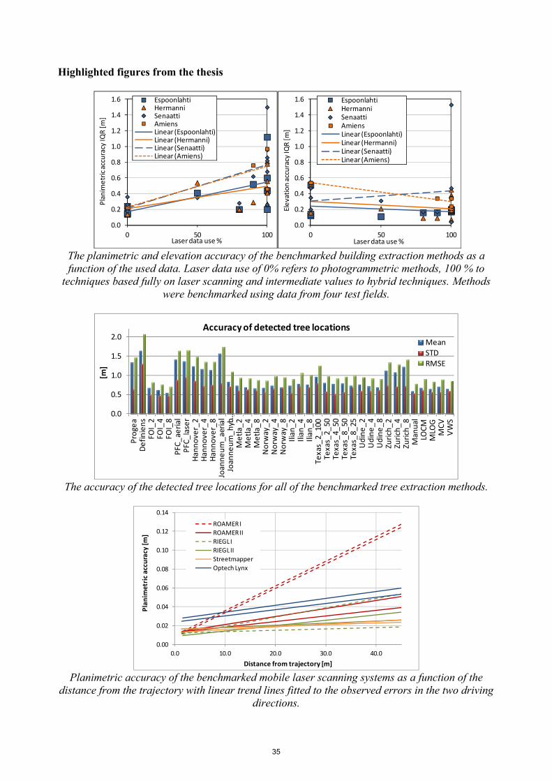
The planimetric and elevation accuracy of the benchmarked building extraction methods as a function of the used data. Laser data use of 0% refers to photogrammetric methods, 100 % to
techniques based fully on laser scanning and intermediate values to hybrid techniques. Methods were benchmarked using data from four test fields.
0.0
0.5
1.0
1.5
2.0
Progea
Definiens
FOI_2
FOI_4
FOI_8
PFC_aerial
PFC_laser
Hannover_2
Hannover_4
Hannover_8
Joanneum_aerial
Joanneum_hyb…
Metla_2
Metla_4
Metla_8
Norw
ay_2
Norw
ay_4
Norw
ay_8
Ilian_2
Ilian_4
Ilian_8
Texas_2_100
Texas_2_50
Texas_4_50
Texas_8_50
Texas_8_25
Udine_2
Udine_4
Udine_8
Zurich_2
Zurich_4
Zurich_8
Manual
LOCM
MLO
GMCV
VWS
[m]
Accuracy of detected tree locations
MeanSTDRMSE
The accuracy of the detected tree locations for all of the benchmarked tree extraction methods.
0.00
0.02
0.04
0.06
0.08
0.10
0.12
0.14
0.0 10.0 20.0 30.0 40.0
Planim
etric accuracy [m]
Distance from trajectory [m]
ROAMER I
ROAMER II
RIEGL I
RIEGL II
Streetmapper
Optech Lynx
Planimetric accuracy of the benchmarked mobile laser scanning systems as a function of the
distance from the trajectory with linear trend lines fitted to the observed errors in the two driving directions.
35

The Photogrammetric Journal of Finland, Vol. 23, No. 2, 2013
PHOTOGRAMMETRIC NEWS: Doctoral Dissertation Mr. Xinlian Liang made his doctoral dissertation on the 4th of October 2013 at the Aalto University School of Engineering, Finland. Professor Håkan Olsson, Swedish University of Agricultural Sciences, Department of Forest Resource Management, appeared as opponent. The title of the thesis was “Feasibility of Terrestrial Laser Scanning for Plotwise Forest Inventories”. (Photo: Matti Kurkela) Abstract of the thesis
Detailed, up-to-date forest information is increasingly important in quantitative forest inventories. The accuracy of the information retrieval is highly dependent on the quality and quantity of the reference data collected on field sample plots. In practice, the plotwise forest data are used as a reference for the calibration of large-area inventory data measured by aerial and space-borne remote sensing techniques. Field reference data are conventionally collected at the sample plot level by manual measurements. Because of the high costs and labor intensity of manual measurements, the number of tree attributes collected is limited. Some of the most important tree attributes are not even measured or sampled.
Terrestrial laser scanning (TLS) has been recently shown to be a promising technique for forest-related studies. Many tree attributes have been correlated with measurements from TLS data. Numerous TLS methods have been proposed. However, the feasibility of applying TLS in plotwise forest inventories is still unclear. The major missing factor is automation of data processing. Other factors hampering the acceptance of the technology include the relatively high cost of the TLS instrument, the low measurement accuracy achieved using the automated data processing currently available, and the shortage of experimental results related to the retrieval of advanced stem attributes (e.g., stem curve) and to different forest conditions.
In this study, a series of methods to map sample plots were developed, and their applicability in plotwise forest inventories was analyzed. The accuracy of stem mapping, the efficiency of data collection, and the limitations of the techniques were discussed. The results indicate that TLS is capable of documenting a forest sample plot in detail and that automated mapping methods yield accurate measurements of the most important tree attributes, such as diameter at breast height and stem curve. The fully-automated TLS data processing that was developed in this study resulted in measurement accuracy similar to that of manual measurements using conventional tools or models and of manual measurements from point cloud data. The results of this study support the feasibility of TLS for practical forest field inventories.
Further research is needed to explore new protocols for the application of TLS in field inventories. Three possible new directions are the integration of detailed tree attributes (e.g., stem curve, volume, and biomass) in large-area inventories, the utilization of TLS field plots in national forest inventories, and the mapping of large sample plots, e.g., in operational harvest planning. More studies need to be performed on sample plots under different forest conditions (development class, tree species, and amount of ground vegetation). Keywords: terrestrial laser scanning, forest inventories, stem curve, volume, biomass, change detection
36

Highlighted figures from the thesis
The segmentation input and result. (A. the original data matrix; B. the scan line continuousness
segmentation results (Liang, X., Litkey, P., Hyyppä, J., Kaartinen, H., Kukko, A., Holopainen, M., 2011. Automatic plot-wise tree location mapping using single-scan terrestrial laser scanning. The
Photogrammetric Journal of Finland, 22(2): 37–48)
The detection in forest structure over time: (a) the TLS data at Time I; (b) the TSL data at Time
II; (c) the laser points from the changed stems; (d) the stem models. (Liang, X., Hyyppä, J., Kaartinen, H., Holopainen, M., Melkas, T., 2012. Detecting changes in forest structure over time with bi-
temporal terrestrial laser scanning data. ISPRS International Journal of Geo-Information, 1(3): 242-255.)
37

The Photogrammetric Journal of Finland, Vol. 23, No. 2, 2013
PHOTOGRAMMETRIC NEWS: Doctoral Dissertation Mr. Lauri Markelin made his doctoral dissertation on the 20th of September 2013 at the Aalto University School of Engineering, Finland. Assistant Professor Markus Gerke, Faculty of Geo-Information Science and Earth Observation, University of Twente, Enschede, The Netherlands, and Dr. Nicolas Paparoditis, Laboratoire MATIS, Institut Géographique National, Paris, France, appeared as opponent. The title of the thesis was “Radiometric calibration, validation and correction of multispectral photogrammetric imagery”. (Photo: Matti Kurkela) Abstract of the thesis Airborne photogrammetry provides a flexible method for acquiring high-resolution imagery in a timely manner over large areas. Aerial images are increasingly being used in a more automatic and quantitative way for applications such as land cover classification and environmental monitoring. Apart from the high geometric quality of photogrammetric sensors, also their radiometric properties are important. Different objects reflect solar irradiance according to their individual spectral and directional properties, and radiometric analysis can be used to identify such objects and changes in them. The perquisite for quantitative radiometry is the absolute radiometric calibration of the sensor, which links the recorded digital numbers to physical units. The major benefit of a radiometrically calibrated sensor is the possibility to radiometrically correct images form atmospheric effects to surface reflectance. Radiometric correction becomes a necessity, when imagery from different dates and sensors are used for quantitative image analysis. The objectives of this study were, first, to develop a vicarious method for the radiometric calibration and validation (Cal/Val) of a photogrammetric sensor in a test field. Second, three radiometric correction methods suitable for reflectance image product generation from photogrammetric images were evaluated. Finally, the influence of the solar elevation angle in the radiometric performance of multispectral photogrammetry was evaluated. The Cal/Val method developed in this study utilizes field measured nadir reflectance factors of the reference targets to match the reflectance factors measured at a laboratory in an exact imaging geometry to the current weather conditions. When evaluating the radiometric correction methods, a reflectance accuracy level of 5 % was achievable with all of the evaluated methods when using well-defined isotropic reference targets. The results showed that a low solar elevation of 25° did not cause the general performance of the photogrammetric processes and 3D point cloud generation to deteriorate. The results presented in this study confirmed the high radiometric quality of photogrammetric sensors and proved the suitability of the photogrammetric imagery for radiometric correction. This makes possible the rigorous radiometric processing of photogrammetric images and improves the quality and accuracy of automatic image interpretation and classification tasks. The applications that are expected to gain advance from the presented radiometric processing methods include vegetation health monitoring through vegetation indices, time series analysis and change
38
detection. Also, radiometrically corrected images and products derived from them can be quantitatively compared and combined with other datasets collected with airborne and space borne sensors. Keywords: photogrammetry, radiometric calibration, radiometric correction, airborne imaging, multispectral, radiative transfer modelling Highlighted figures from the thesis
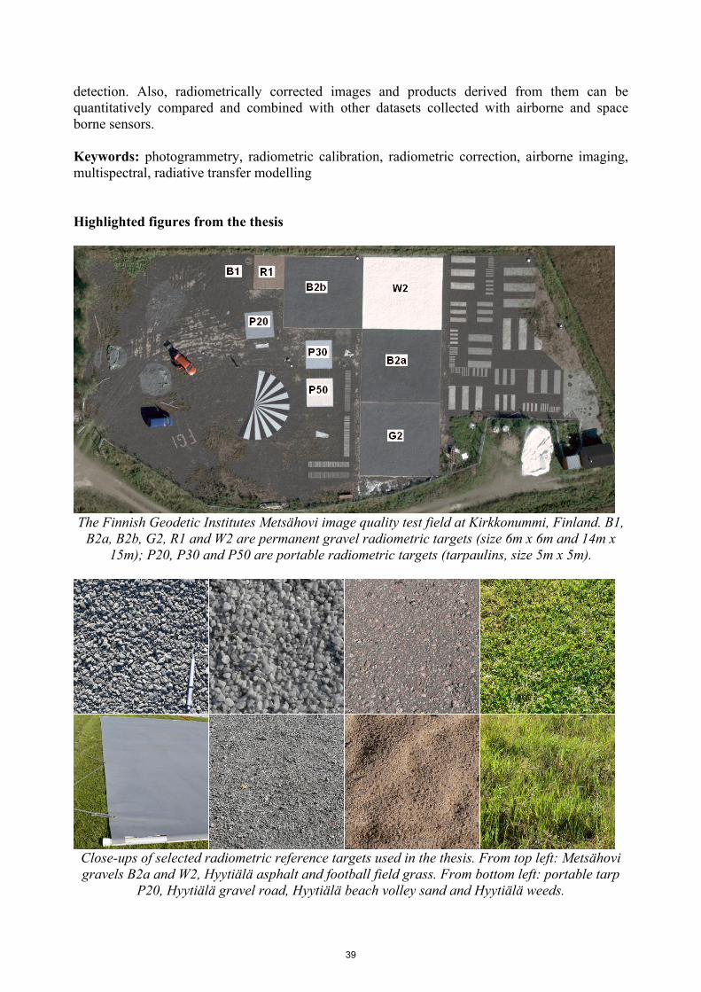
The Finnish Geodetic Institutes Metsähovi image quality test field at Kirkkonummi, Finland. B1,
B2a, B2b, G2, R1 and W2 are permanent gravel radiometric targets (size 6m x 6m and 14m x 15m); P20, P30 and P50 are portable radiometric targets (tarpaulins, size 5m x 5m).
Close-ups of selected radiometric reference targets used in the thesis. From top left: Metsähovi gravels B2a and W2, Hyytiälä asphalt and football field grass. From bottom left: portable tarp
P20, Hyytiälä gravel road, Hyytiälä beach volley sand and Hyytiälä weeds.
39

The Photogrammetric Journal of Finland, Vol. 23, No. 2, 2013
PHOTOGRAMMETRIC NEWS: Doctoral Dissertation Ms. Sari Metsämäki made her doctoral dissertation on the 23rd of August 2013 at the Aalto University School of Engineering, Finland. Dr., Research Professor Tuomas Häme, VTT Technical Research Centre of Finland, Espoo, and Dr., Professor Richard Kelly, University of Waterloo, Department of Geography and Environmental Management, Ontario, Canada, appeared as opponent. The title of the thesis was “A fractional snow cover mapping method for optical remote sensing data, applicable to continental scale”. (Photo: Matti Kurkela) Abstract of the thesis This doctoral thesis focuses on the determination of fractional snow coverage (FSC) from optical data provided by satellite instruments. It describes the method development starting from a simple regionally applicable linear interpolation method and ending at a globally applicable semi-empirical modeling approach. The development work has been motivated by the need for an easily implementable and feasible snow mapping method that could provide reliable information particularly for forested areas. Contribution of the work to the optical remote sensing of snow is mostly related to the accounting for boreal forest canopy effect to the observed reflectance, thus facilitating accurate fractional snow retrievals also for ground beneath the tree canopies. The first proposed approach was based on a linear interpolation technique, which relies on a priori known reference reflectances at a) full snow cover and b) snow-free conditions for each calculation unit-area. An important novelty in the methodology was the utilization of a forest sparseness index determined from AVHRR reflectance data acquired at full dry snow cover conditions. This index was employed to describe the similarity between different unit-areas. In practice, the index was used to determine the reference reflectances for such unit-areas for which the reflectance level could not be determined otherwise e.g. due to frequent cloud cover. This approach was found feasible for Finnish drainage basins introducing fragmented landscape with moderate canopies. Using a more physical approach instead of linear interpolation would allow the model parameterization using physical quantities (reflectances) and would therefore leave space for further model developments based on measuring and/or modeling of these quantities. The semi-empirical reflectance model-based method SCAmod originates from radiative transfer theory and describes the scene-level reflectance as a mixture of three major constituents – opaque forest canopy, snow and snow-free ground, which are interconnected through transmissivity and snow fraction. Transmissivity, in turn, can be derived from reflectance observations under conditions that highlight the presence of forest canopy – namely the presence of full snow cover on the ground. Thus, SCAmod requires a priori information on transmissivity, but given that it can be determined with the appropriate accuracy, it enables consideration for the obstructing effects of forests in fractional snow estimation. In continental-scale snow mapping, determination of the transmissivity map becomes a key issue. The preliminary demonstration of transmissivity generation using global land cover data was a part of this study.
40

The first implementations and validations for SCAmod were presented for AVHRR data at Finnish drainage basin scale. In subsequent work, determination of the feasible reflectance constituents was addressed, followed by a sensitivity analysis targeting at selection of optimal spectral bands to be applied with SCAmod. Feasibility of NDSI-based approach in FSC-retrievals over boreal forests is also discussed. Finally, the implementations and validations for MODIS and AATSR data are presented. The results from relative (using high-resolution Earth Observation data to represent the truth) and absolute validation (using in situ observations) indicate a good performance for both forested and non-forested regions in Northern Eurasia. Accounting for the effect of forest canopy in the FSC-retrievals is the key issue in snow remote sensing over boreal regions; this study provides a new contribution to this research field and provides one solution for continental scale snow mapping. Keywords: Snow, Fractional snow cover, Boreal zone, Forests, Tundra, Optical remote sensing Highlighted figures from the thesis
Fractional snow cover in a boreal forest in Northern Finland.
A monthly-aggregated map of Fractional snow cover, March 2003, produced applying the SCAmod-method described in the thesis. GlobSnow Snow Extent v1.2, www.globsnow.info.
41