photo credit: fruition environmental project update about ... · project to date: • approximately...
TRANSCRIPT
A number of important milestones have been completed in the project to date:
• Approximately 17.4 ha of priority gully areas have been remediated between 2017-2019, which represents the largest gully remediation project in the Great Barrier Reef catchments.
• Water quality monitoring has been undertaken during the 2018/19 wet season over 7 rainfall events. 110 samples have been collected across all treatment sites.
• It is estimated the first two phases of the project are preventing over 4,000 tonnes of sediment run-off to the Great Barrier Reef per year. This is expected to increase to >6,000 tonnes with the completion of 2019 works.
• Greening Australia’s Reef Aid™ fundraising program has to date raised $1.75M of co-contribution to match the Queensland Government’s $2M commitment for this project.
The Innovative Gully Remediation Project is a collaborative project supported by the Queensland Government’s Reef Water Quality Program and Greening Australia’s Reef Aid™ Program.
This project’s purpose is to identify more innovative and cost-effective gully remediation techniques applicable to the Great Barrier Reef catchments and communicate the outcomes of the trials to ensure broad uptake of best practice gully remediation techniques.
The remediation trials under the project are being conducted in collaboration with the Hughes family on Strathalbyn Station, in the East Burdekin priority sediment reduction catchment.
More information on the Innovative Gully Remediation Project can be found at www.greeningaustralia.org.au/projects/rebuilding-eroding-land-2
Project update About the project
COMMUNIQUE THREE Post-works monitoring outcomes
Photo credit: Fruition Environmental
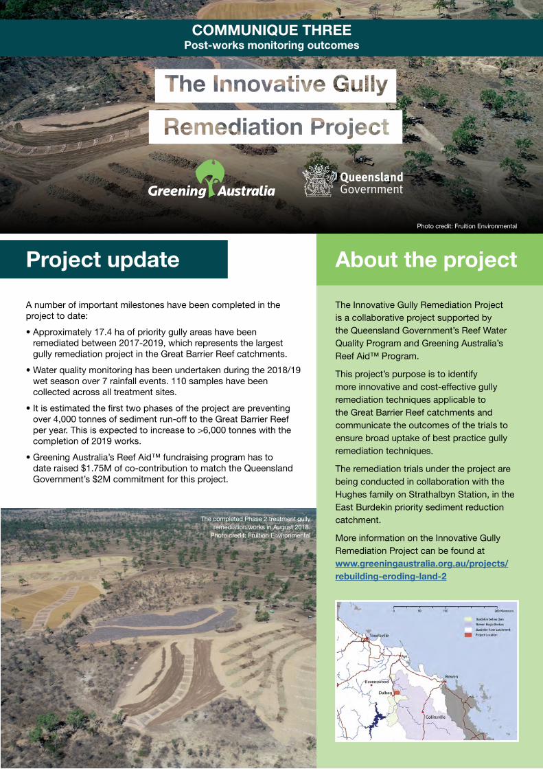
The completed Phase 2 treatment gully remediation works in August 2018.
Photo credit: Fruition Environmental
• Water quality parameters including suspended sediment concentration, particle size distribution, nutrient concentration
• Water flow parameters such as velocity and depth
• Soil parameters including structural stability, dispersiveness, soil nutrient status, levels of soil carbon and organic matter
• Vegetation parameters including land condition assessments and direct seeding germination rates associated with different treatments
• Post-treatment land form changes as determined by remote sensing technologies including high resolution aerial LiDAR, terrestrial LiDAR or RTK survey
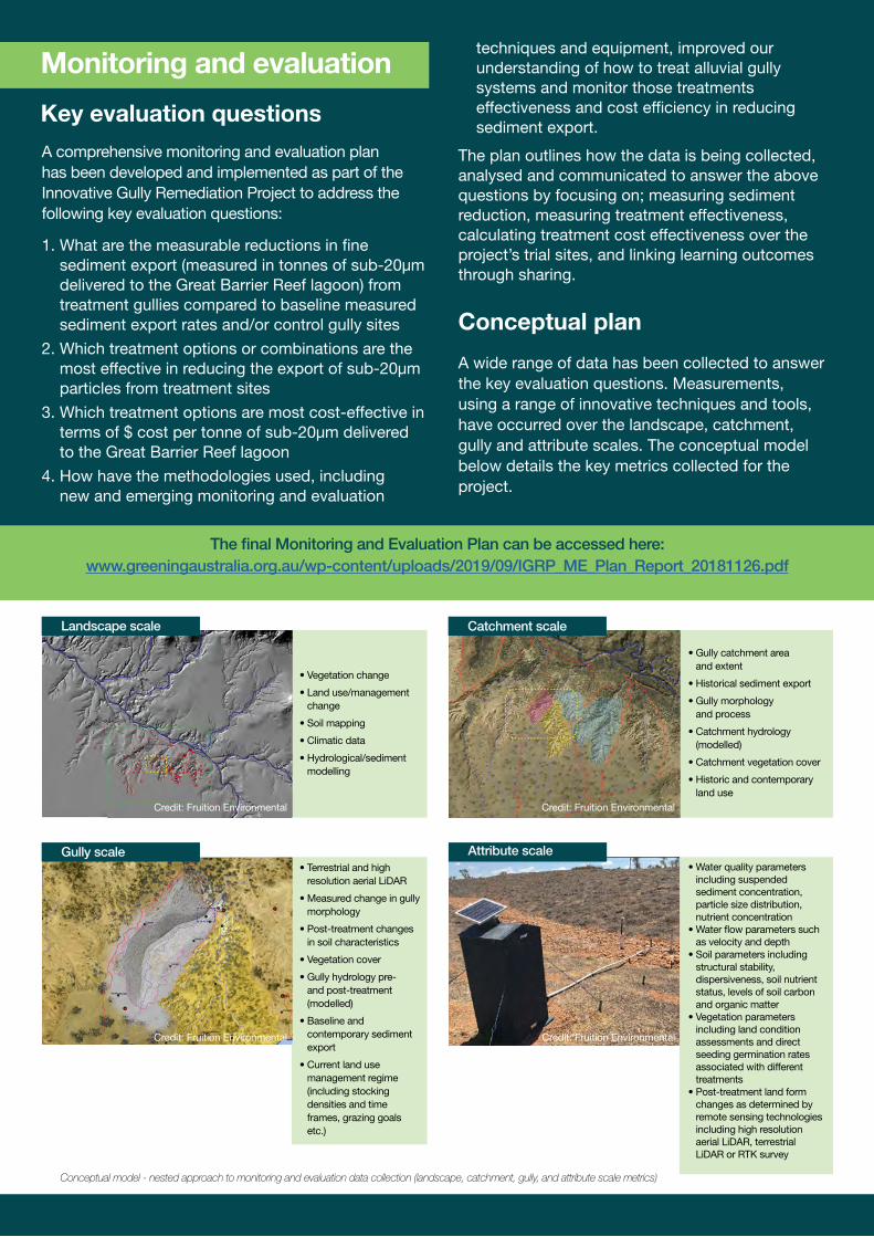
Landscape scale
• Terrestrial and high resolution aerial LiDAR
• Measured change in gully morphology
• Post-treatment changes in soil characteristics
• Vegetation cover
• Gully hydrology pre-and post-treatment (modelled)
• Baseline and contemporary sediment export
• Current land use management regime (including stocking densities and time frames, grazing goals etc.)
Gully scale
• Gully catchment area and extent
• Historical sediment export
• Gully morphology and process
• Catchment hydrology (modelled)
• Catchment vegetation cover
• Historic and contemporary land use
Catchment scale
Attribute scale
• Vegetation change
• Land use/management change
• Soil mapping
• Climatic data
• Hydrological/sediment modelling
A comprehensive monitoring and evaluation plan has been developed and implemented as part of the Innovative Gully Remediation Project to address the following key evaluation questions:
A wide range of data has been collected to answer the key evaluation questions. Measurements, using a range of innovative techniques and tools, have occurred over the landscape, catchment, gully and attribute scales. The conceptual model below details the key metrics collected for the project.
1. What are the measurable reductions in fine sediment export (measured in tonnes of sub-20μm delivered to the Great Barrier Reef lagoon) from treatment gullies compared to baseline measured sediment export rates and/or control gully sites
2. Which treatment options or combinations are the most effective in reducing the export of sub-20μm particles from treatment sites
3. Which treatment options are most cost-effective in terms of $ cost per tonne of sub-20μm delivered to the Great Barrier Reef lagoon
4. How have the methodologies used, including new and emerging monitoring and evaluation
techniques and equipment, improved our understanding of how to treat alluvial gully systems and monitor those treatments effectiveness and cost efficiency in reducing sediment export.
The plan outlines how the data is being collected, analysed and communicated to answer the above questions by focusing on; measuring sediment reduction, measuring treatment effectiveness, calculating treatment cost effectiveness over the project’s trial sites, and linking learning outcomes through sharing.
Monitoring and evaluation
Key evaluation questions
Conceptual plan
Conceptual model - nested approach to monitoring and evaluation data collection (landscape, catchment, gully, and attribute scale metrics)
The final Monitoring and Evaluation Plan can be accessed here:www.greeningaustralia.org.au/wp-content/uploads/2019/09/IGRP_ME_Plan_Report_20181126.pdf
Credit: Fruition Environmental Credit: Fruition Environmental
Credit: Fruition Environmental Credit: Fruition Environmental
Pre-works data included preliminary landscape and catchment scale metrics as well as baseline sediment export and hydrological data in gullies prior to intervention. The data enabled an understanding of the existing conditions of the project site, and historic sediment export prior to remediation works, allowing for comparisons pre-and post-treatment to establish effectiveness.
The program uses a modified Before-After-Control-Impact (BACI) approach with a single control gully located centrally between the treated gullies. Not all treatment gullies have complete baseline data, and different techniques have been used where there is no defined gully outlet for sampling event flows, hence a modified design.
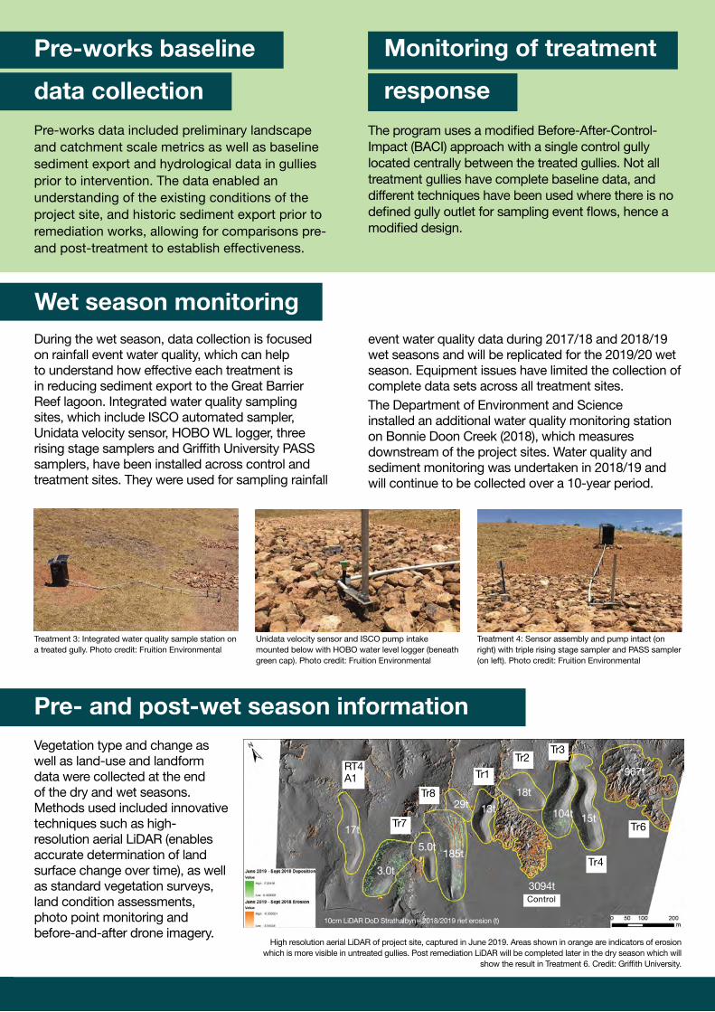
During the wet season, data collection is focused on rainfall event water quality, which can help to understand how effective each treatment is in reducing sediment export to the Great Barrier Reef lagoon. Integrated water quality sampling sites, which include ISCO automated sampler, Unidata velocity sensor, HOBO WL logger, three rising stage samplers and Griffith University PASS samplers, have been installed across control and treatment sites. They were used for sampling rainfall
Vegetation type and change as well as land-use and landform data were collected at the end of the dry and wet seasons. Methods used included innovative techniques such as high-resolution aerial LiDAR (enables accurate determination of land surface change over time), as well as standard vegetation surveys, land condition assessments, photo point monitoring and before-and-after drone imagery.
event water quality data during 2017/18 and 2018/19 wet seasons and will be replicated for the 2019/20 wet season. Equipment issues have limited the collection of complete data sets across all treatment sites.The Department of Environment and Science installed an additional water quality monitoring station on Bonnie Doon Creek (2018), which measures downstream of the project sites. Water quality and sediment monitoring was undertaken in 2018/19 and will continue to be collected over a 10-year period.
Conceptual plan
High resolution aerial LiDAR of project site, captured in June 2019. Areas shown in orange are indicators of erosion which is more visible in untreated gullies. Post remediation LiDAR will be completed later in the dry season which will
show the result in Treatment 6. Credit: Griffith University.
Monitoring of treatment
response
Wet season monitoring
Pre- and post-wet season information
Pre-works baseline
data collection
Tr7 Tr6
Tr4
Control
Tr8
RT4A1 Tr1
Tr2Tr3
17t
3.0t
5.0t185t
10cm LiDAR DoD Strathalbyn - 2018/2019 net erosion (t)
29t 13t
3094t
18t
104t 15t
967t
Treatment 4: Sensor assembly and pump intact (on right) with triple rising stage sampler and PASS sampler (on left). Photo credit: Fruition Environmental
Unidata velocity sensor and ISCO pump intake mounted below with HOBO water level logger (beneath green cap). Photo credit: Fruition Environmental
Treatment 3: Integrated water quality sample station on a treated gully. Photo credit: Fruition Environmental
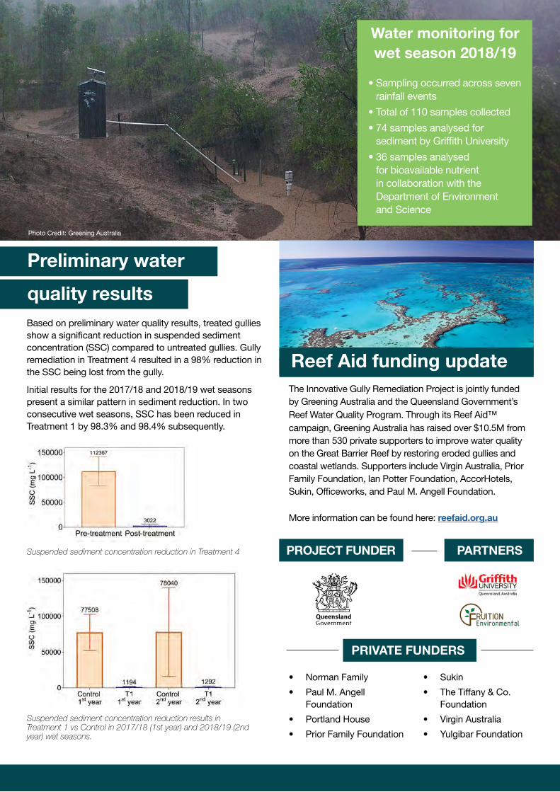
Based on preliminary water quality results, treated gullies show a significant reduction in suspended sediment concentration (SSC) compared to untreated gullies. Gully remediation in Treatment 4 resulted in a 98% reduction in the SSC being lost from the gully.
Initial results for the 2017/18 and 2018/19 wet seasons present a similar pattern in sediment reduction. In two consecutive wet seasons, SSC has been reduced in Treatment 1 by 98.3% and 98.4% subsequently.
Reef Aid funding update
• Sampling occurred across seven rainfall events
• Total of 110 samples collected
• 74 samples analysed for sediment by Griffith University
• 36 samples analysed for bioavailable nutrient in collaboration with the Department of Environment and Science
Water monitoring for wet season 2018/19
Preliminary water
quality results
The Innovative Gully Remediation Project is jointly funded by Greening Australia and the Queensland Government’s Reef Water Quality Program. Through its Reef Aid™ campaign, Greening Australia has raised over $10.5M from more than 530 private supporters to improve water quality on the Great Barrier Reef by restoring eroded gullies and coastal wetlands. Supporters include Virgin Australia, Prior Family Foundation, Ian Potter Foundation, AccorHotels, Sukin, Officeworks, and Paul M. Angell Foundation. More information can be found here: reefaid.org.au
Suspended sediment concentration reduction in Treatment 4
Suspended sediment concentration reduction results in Treatment 1 vs Control in 2017/18 (1st year) and 2018/19 (2nd year) wet seasons.
Photo Credit: Greening Australia
• Norman Family
• Paul M. Angell Foundation
• Portland House
• Prior Family Foundation
• Sukin
• The Tiffany & Co. Foundation
• Virgin Australia
• Yulgibar Foundation