philwaves laguna de bay basin - wavespartnership.org · maynilad and manila ... zoning map 3....
TRANSCRIPT

Updates on the WAVES for the
Laguna de Bay Basin
Engr. Jocelyn G. Sta. Ana
Sept. 10, 2014
Tagaytay City

LLDA Accounts
• Water Accounts
• Land Accounts
• Fishery Accounts
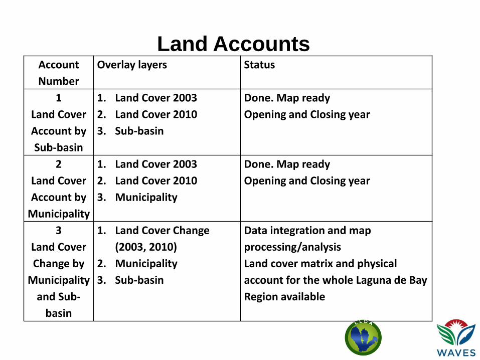
Account
Number
Overlay layers Status
1
Land Cover
Account by
Sub-basin
1. Land Cover 2003
2. Land Cover 2010
3. Sub-basin
Done. Map ready
Opening and Closing year
2
Land Cover
Account by
Municipality
1. Land Cover 2003
2. Land Cover 2010
3. Municipality
Done. Map ready
Opening and Closing year
3
Land Cover
Change by
Municipality
and Sub-
basin
1. Land Cover Change
(2003, 2010)
2. Municipality
3. Sub-basin
Data integration and map
processing/analysis
Land cover matrix and physical
account for the whole Laguna de Bay
Region available
Land Accounts
Account
Numbers
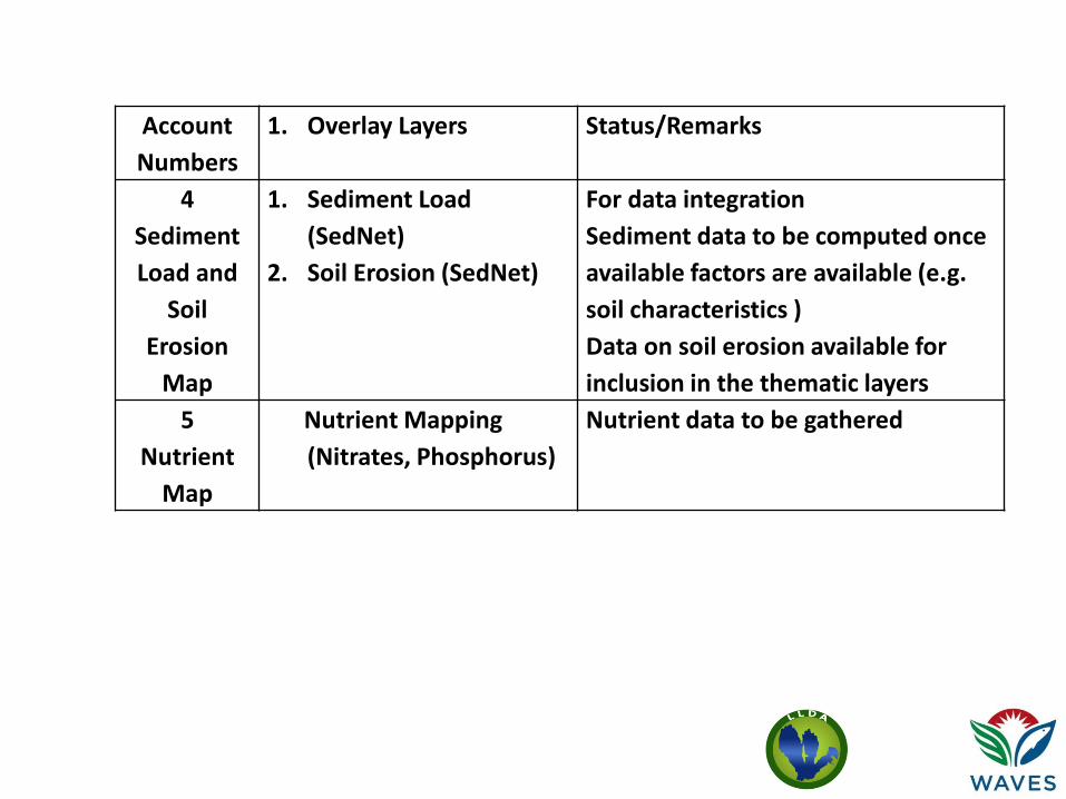
1. Overlay Layers Status/Remarks
4
Sediment
Load and
Soil
Erosion
Map
1. Sediment Load
(SedNet)
2. Soil Erosion (SedNet)
For data integration
Sediment data to be computed once
available factors are available (e.g.
soil characteristics )
Data on soil erosion available for
inclusion in the thematic layers
5
Nutrient
Map
Nutrient Mapping
(Nitrates, Phosphorus)
Nutrient data to be gathered
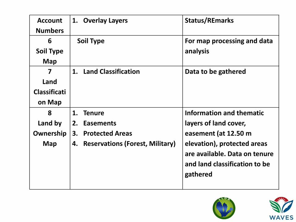
Account
Numbers
1. Overlay Layers Status/REmarks
6
Soil Type
Map
Soil Type
For map processing and data
analysis
7
Land
Classificati
on Map
1. Land Classification Data to be gathered
8
Land by
Ownership
Map
1. Tenure
2. Easements
3. Protected Areas
4. Reservations (Forest, Military)
Information and thematic
layers of land cover,
easement (at 12.50 m
elevation), protected areas
are available. Data on tenure
and land classification to be
gathered

Account
Numbers
1. Overlay Layers Status/Remarks
9
Infra
structures
Map
1. Infrastructures
2. Roads
Infrastructures and road data to be
gathered
10
Geohazard
Map
1. Geohazard
2. Land subsidence
Thematic layers of landcover and
Geohazards are available. Land
subsidence data to be gathered

Account
Numbers
1. Overlay Layers Status/Remarks
11
Quarry
Map
1. Mountain Quarry
2. River Quarry
For data and map processing.
LLDA has data on quarrying
12
Governme
nt Projects
Map
1. Government Big Ticket
Projects
Data about government projects
to be gathered.

Account
Number
Overlay Layers Status/Remarks
1
Industry
Map
1. Wet and Dry Industries (Location)
2. Rivers/Creeks
Data on concentration,
discharge flowrate and BOD
loading available
2
Population
Density
Map
Population Density
With data (in excel), for
mapping
3
Water
Quality Map
Water Quality (BOD, Dissolved
Oxygen)
Water Quality data (in excel
and in graphs), for mapping
Water Accounts
Account
Numbers
Overlay Layers Status Remarks
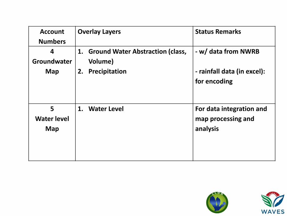
4
Groundwater
Map
1. Ground Water Abstraction (class,
Volume)
2. Precipitation
- w/ data from NWRB
- rainfall data (in excel):
for encoding
5
Water level
Map
1. Water Level For data integration and
map processing and
analysis

Account
Numbers
Overlay Layers Status/Remarks
6
Flooding Map
Extreme Weather Events - with data, for mapping
7
Streamflow
Map
Streamflow - with data, for mapping
Account
Numbers
Overlay layers Status /Remarks
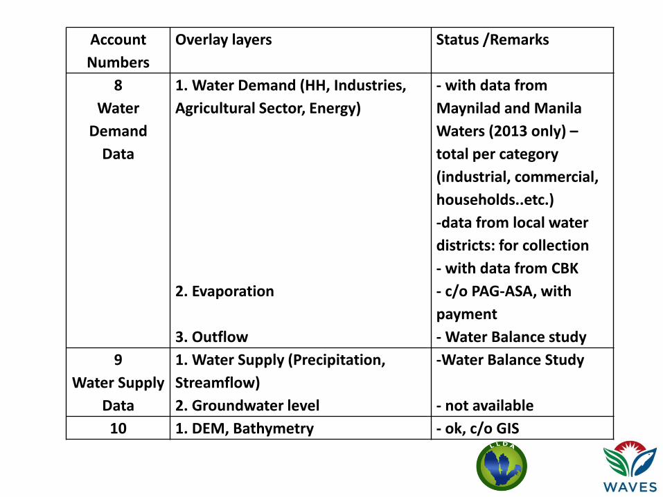
8
Water
Demand
Data
1. Water Demand (HH, Industries,
Agricultural Sector, Energy)
2. Evaporation
3. Outflow
- with data from
Maynilad and Manila
Waters (2013 only) –
total per category
(industrial, commercial,
households..etc.)
-data from local water
districts: for collection
- with data from CBK
- c/o PAG-ASA, with
payment
- Water Balance study
9
Water Supply
Data
1. Water Supply (Precipitation,
Streamflow)
2. Groundwater level
-Water Balance Study
- not available
10 1. DEM, Bathymetry - ok, c/o GIS

Account
Number
Overlay layers Status
1
Fish
Harvest/
Production
Data
1. Fish Harvest/Production
2. Water Quality (Chloride)
3. Aquaculture Stocking Density)
4. Primary Production
-2002 to 2013 data obtained from BAS website -2003 to 2013 data in LLDA-ELRD obtained. -Information obtained from LLDA-Clearances and Permits Division (CPD)
- 2003 to 2013 data
Fishery Accounts

Account
Number
1. Overlay Layers Status/Remarks
2 1. Extreme Event
2. Sedimentation
3. Nutrient Mapping
4. Primary Productivity
5. Chlorophyll A
6. Fish kill
7. TSS
8. Turbidity
-Data on affected families for Ondoy
and Habagat taken from NDRMMC
-To be obtained from BSWM
- To be obtained from BSWM
-2003 to 2013 data
- 2003 to 2013 data
- 2003 to 2013 fishkill occurrence to be
completed
- 2003 to 2013 data
- 2003 to 2013 data

Account
Number
1. Overlay Layers Status/Remarks
3 1. Fishpens/Fish cages
2. Zoning Map
3. Demolition Reports
-Data on the numbers and areas of registered and unregistered fishcages and fishpens obtained from LLDA-Clearances and Permits Division (CPD)
-To be digitized in Google Earth
-With existing data from LLDA-
Enforcement Division (ED); to be
obtained

Account
Number
1. Overlay Layers Status/Remarks
4 1. Policy Issuances
2. Violation records
3. Price Changes
-Issued LLDA Board Resolutions and Memoranda available in the LLDA Publication entitled "Milestone Compilation of LLDA Laws, Rules and Regulations" and from the Office of the LLDA Board of Directors -With existing data from LLDA-Enforcement Division (ED); to be obtained -2004 to 2013 annual market price of fish for the provinces of Laguna and Rizal obtained from BAS.

2003
Land Cover
Map

2010
Land Cover
Map
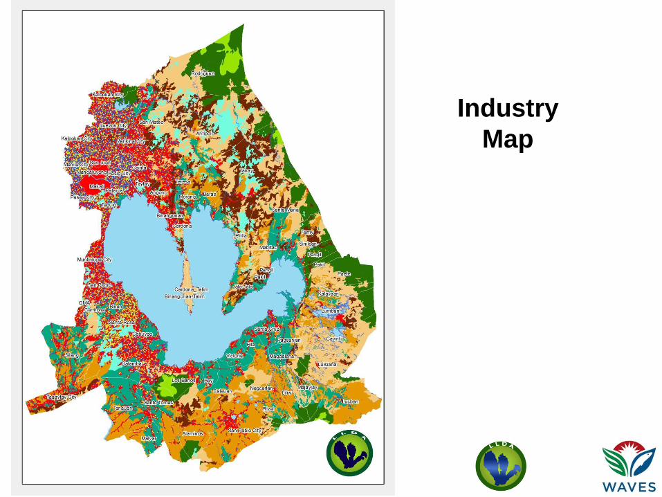
Industry
Map

Industry
Map

Map of the
Water Quality
Monitoring
Stations
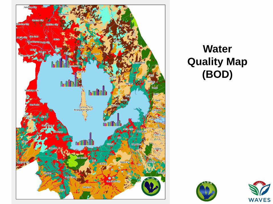
Water
Quality Map
(BOD)

Lake
Municipal
Boundaries
Map
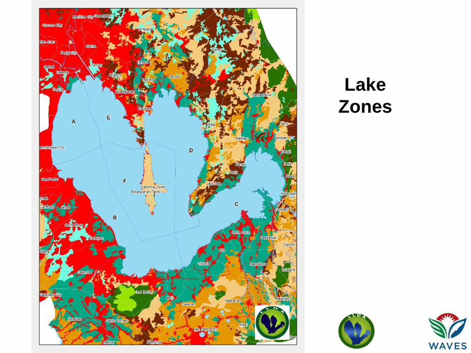
Lake
Zones

Issues/Concerns • Need additional GIS Experts for the water and
fishery account groups
• Pag-asa data – with payment
• Data are not dis-aggregated
• Additional workload for the TWG members
• Internal problems due to office transfer

Training Needs
• Data processing and management
• GIS processing , mapping and analysis
• Biophysical modelling (SedNet)
• Valuation/Ecosystem Accounting