phi: integrated natural resources and environmental ... · php 1.00 = $ 0.01986 $1.00 = php 50.34...
TRANSCRIPT
Initial Environmental Examination
January 2018
PHI: Integrated Natural Resources and Environmental Management ProjectRehabilitation of New Eden, Concepcion Access Road
and Foot Trail in Pangantucan, Bukidnon
Prepared by Municipality of Pangantucan, Province of Bukidnon for the Asian Development
Bank.

ii
CURRENCY EQUIVALENTS (as of 30 November 2017 Year)
The date of the currency equivalents must be within 2 months from the date on the cover. Currency unit – peso (PhP)
PhP 1.00 = $ 0.01986 $1.00 = PhP 50.34
ABBREVIATIONS
ADB Asian Development Bank BDC Barangay Development Council BUB Bottom-Up Budgeting CNC Certificate of Non Coverage CSC Construction Supervision Consultant CSO Civil Society Organization DED Detail Engineering Design DENR Department Of Environment And Natural Resources DILG Department of Interior and Local Government DSWD Department of Social Welfare and Development ECA Environmentally Critical Area ECC Environmental Compliance Certificate ECP Environmentally Critical Project EHSM Environmental Health And Safety Manager EIA Environmental Impact Assessment EIS Environmental Impact Statement EMB ESS
Environmental Management Bureau Environmental Safeguards Specialist
GAD Gender And Development IEE Initial Environmental Examination INREMP Integrated Natural Resources and Environment Management Project IP Indigenous People IROW Infrastructure Right Of Way LGU Local Government Unit LPRAT Local Poverty Reduction Action Team MDC Municipal Development Council MPN Most Probable Number NAAQ National Ambient Air Quality Guidelines NCB National Competitive Bidding NECA Non Environmental Critical Area NECP Non Environmental Critical Project NIA National Irrigation Administration NPCO National Project Coordinating Office NRIMP National Road Improvement And Management Program NRM Natural Resources Management OMC Overhead, Contingencies And Miscellaneous And Contractor’s PAGASA Philippine Atmospheric Geophysical and Astronomical Services
Administration PWA Pangantucan Water Association PDR Project Description Report PMIC Project Management Implementation Consultant PPCO Provincial Project Management
Offices

iii
PMO Project Management Office PMU Project Management Unit POs Peoples’ Organizations PSA PTTAI
Philippine Statistics Authority Portulin Talaandig Traibal Association Incorporated
PWD Persons With Disability RC Reinforced Concrete RCPC Reinforced Concrete Pipe Culvert RPCO Regional Project Coordinating Offices REA Rapid Environmental Assessment ROW Right Of Way SB Sangguniang Bayan SBD Standard Bidding Document SEMS Social And Environmental Management Systems SPMU Sub-Project Management Unit SPS SSS
Safeguard Policy Statement Social Safeguards Specialist
TA Technical Assistance TDS Total Dissolved Solids TOR Terms Of Reference TSP Total Suspended Particulates WMA Watershed Management Area WMPCO Watershed Management And Project Coordination Offices

iv
WEIGHTS AND MEASURES
˚C – degree centigrade ha – hectare km – kilometer m – meter
m asl – meter above sea level mm – millimeter
mg/L – milligram per liter mg/Nm3 – milligram per normal cubic meter
ppt – parts per thousand μg/Nm3 – microgram per normal cubic meter
µS/cm – microSiemens/cm % – percent
NOTE
In this report, "$" refers to US dollars unless otherwise stated. This initial environmental examination is a document of the borrower. The views expressed herein do not necessarily represent those of ADB's Board of Directors, Management, or staff, and may be preliminary in nature. In preparing any country program or strategy, financing any project, or by making any designation of or reference to a particular territory or geographic area in this document, the Asian Development Bank does not intend to make any judgments as to the legal or other status of any territory or area.

v
TABLE OF CONTENTS
I. EXECUTIVE SUMMARY ............................................................................................... 1 II. POLICY, LEGAL, AND ADMINISTRATIVE FRAMEWORK ........................................... 2 A. Environmental Clearance Requirements .................................................................... 2
1. Government Environmental Laws, Regulations and Guidelines .................................. 2 2. ADB Environmental Assessment Requirements ......................................................... 5
III. DESCRIPTION OF THE PROJECT ............................................................................... 6 A. Overview ....................................................................................................................... 6 A. Project Location ........................................................................................................... 7 B. Project Rationale .......................................................................................................... 7 C. Project Development Plan ........................................................................................... 9
1. Project Components ................................................................................................... 9 2. Description of the Project Phases ............................................................................. 11
D. Manpower Requirements .......................................................................................... 11 E. Project Cost ................................................................................................................ 12 F. Project Duration and Schedule ................................................................................. 13 IV. DESCRIPTION OF THE ENVIRONMENT .................................................................... 13 A. Elevation and Slope ................................................................................................... 14 B. Geology ...................................................................................................................... 15 C. Soil .............................................................................................................................. 16 E. Land Classification ................................................................................................. 17 F. Land Cover and Land Use ......................................................................................... 17 G. Climate ........................................................................................................................ 21
1. Base Climate ............................................................................................................ 21 1. Climate scenario for Bukidnon Province in 2020 and 2050 ....................................... 21
I. Natural Hazards .......................................................................................................... 23 H. Biological Environment ............................................................................................. 24
1. Flora and Fauna ....................................................................................................... 24 K. Socio-Economic Conditions .................................................................................... 26
1. Population ................................................................................................................ 26 2. Influence Area Population ........................................................................................ 27 3. Poverty Threshold .................................................................................................... 28 4. Indigenous Peoples .................................................................................................. 29 5. Civil Society Organization ......................................................................................... 30 6. Education ................................................................................................................. 30 7. Health Services ........................................................................................................ 30 8. Housing .................................................................................................................... 31 9. Transportation and Road Networks .......................................................................... 31 10. Waterworks Facilities ............................................................................................ 32 11. Power ................................................................................................................... 33 12. Communication ..................................................................................................... 33 13. Tourism ................................................................................................................. 34
V. ANTICIPATED ENVIRONMENTAL IMPACTS AND MITIGATION MEASURES .......... 34 A. Pre-Construction ........................................................................................................ 36
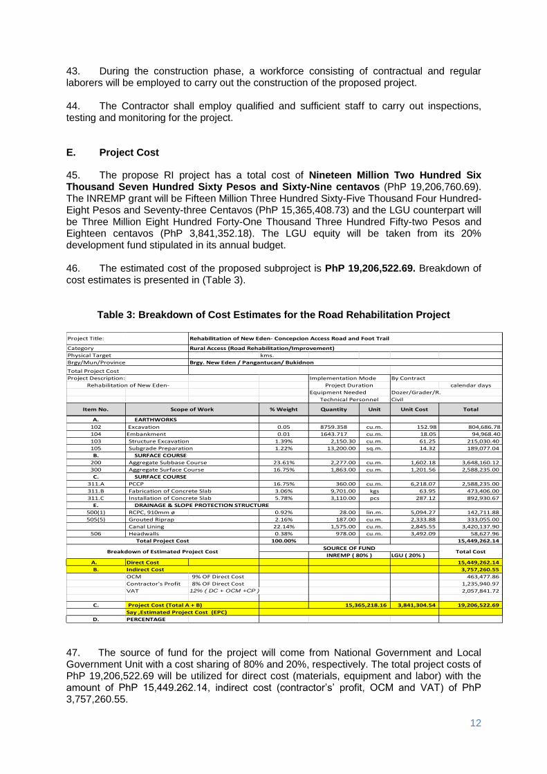
1. Confirmation of no required resettlement, relocations, and compensation ................ 36 2. Identification and prioritization of road section where re-gravelling will be done ........ 36 3. Preparation of detailed engineering designs and programs of work .......................... 36 4. Recruitment of workers ............................................................................................. 36
B. Construction .............................................................................................................. 36
vi
1. Construction materials acquisition, transport access, and storage system ................ 36 2. Clearing and removal of obstructions ....................................................................... 37 1. Soil erosion .............................................................................................................. 37 2. Ground surface leveling and gravelling of existing road ............................................ 37 3. Civil works ................................................................................................................ 37 4. Implementation of noise and dust control measure ................................................... 38 5. Dust and noise from borrow pits ............................................................................... 38 6. Implementation of spoil management and control measure ...................................... 38 7. Solid and liquid construction waste management system ......................................... 38 8. Water quality ............................................................................................................ 38 9. Construction drainage system .................................................................................. 39 10. Workers health, safety and hygiene ...................................................................... 39 11. Traffic safety and management ............................................................................. 39 12. Ecological environment (Flora and Fauna) ............................................................ 40 13. Damaged to properties ......................................................................................... 40 14. Concrete washout ................................................................................................. 40 15. Use of Hazardous Substances .............................................................................. 40 16. Public safety ......................................................................................................... 41
C. Operation and Maintenance (O&M) Phase ............................................................... 41 1. Operation of upgraded access road .......................................................................... 41
VI. INFORMATION DISCLOSURE, CONSULTATION, AND PARTICIPATION ................ 41 A. Stakeholder Consultations ........................................................................................ 41 B. Information Disclosure .............................................................................................. 43 VII. GRIEVANCE REDRESS MECHANISM ....................................................................... 44 VIII. ENVIRONMENTAL MANAGEMENT PLAN ................................................................. 46 A. Implementation Arrangements ................................................................................. 46 B. Environmental Mitigation .......................................................................................... 47 C. Environmental Monitoring ......................................................................................... 56 IX. CONCLUSION AND RECOMMENDATION ................................................................. 59 A. Conclusion ................................................................................................................. 59 B. Recommendation ....................................................................................................... 60

vii
LIST OF FIGURES
Figure 1: The Muleta River Watershed and the location of the Proposed RI Subproject ........ 8 Figure 2: Elevation and Slope of the Proposed Subproject ................................................. 15 Figure 3: Land Classification of the Pangantucan, Bukidnon ............................................... 19 Figure 4: Location of the Proposed Road and Foot Trail along the Buffer Zone .................. 20 Figure 5: Record of Tropical Cyclones that Passed through the Region Covering the Influence Watersheds during the Period 1948 - 2009 (PAGASA) .................. 22 Figure 6: Monthly rainfall based on CNCM3 model for 2020s and 2050s periods in Bukidnon Province .......................................................................................... 23 Figure 7: Photographs of Affected Vegetation of the Proposed Subproject ......................... 26 Figure 8: Historical Growth of Population ............................................................................ 27
LIST OF TABLES
Table 1: Summary List of ECP Types and ECA Categories .................................................. 3 Table 2: EIS and IEE Requirements for Road and Bridge Projects ....................................... 4 Table 3: Breakdown of Cost Estimates for the Road Rehabilitation Project ......................... 12 Table 4: Implementation Schedule ...................................................................................... 13 Table 5: Slope Range Classification .................................................................................... 14 Table 6: Soil Series Type within the Muleta Watershed ....................................................... 16 Table 7: Land Area by Barangay per Land Classification .................................................... 18 Table 8: Land - Use by Municipality .................................................................................... 18 Table 9: Projected monthly rainfall based on CNCM3 model with A1b and A2 scenarios for 2020s and 2050s periods in Bukidnon Province ............................. 22 Table 10: Change anomalies of rainfall in Bukidnon Province based on CNCM3 model ..... 23 Table 11: Total Annual Number of Typhoons in the Area .................................................... 24 Table 12: Summary of Flora and Fauna within the Watershed ........................................... 24 Table 13: Population of Barangay Concepcion and New Eden, Pangantucan ..................... 27 Table 14: Member of the Labor Force ................................................................................. 27 Table 15: Age and Sex Desegregation ................................................................................ 28 Table 16: Households with Income below Poverty Threshold .............................................. 29 Table 17: Composition on Ethnic Population ....................................................................... 29 Table 18: Population of IPs in the Influence Area ................................................................ 29 Table 19: Types of Education Facilities ............................................................................... 30 Table 20: School Facilities, Enrolment and Teachers .......................................................... 30 Table 21: Health Facility in Pangantucan Bukidnon ............................................................ 31 Table 22: Household Informal Settlers ................................................................................ 31 Table 23: Distance, Mode and Cost of Transportation......................................................... 32 Table 24: Number of Households Served by Water Systems .............................................. 33 Table 25: Number of Households Energized (Pangantucan) CY 2012-2016 ....................... 33 Table 26: Assessment of Potential Environmental Impacts ................................................. 34 Table 27: Summary of Stakeholder Consultation of the Road Access and Foot Trail Rehabilitation in Pangantucan ...................................................... 42 Table 28: Responsibilities for EMP Implementation ............................................................ 46 Table 29: Environmental Impact Mitigation Plan .................................................................. 47 Table 30: Environmental Monitoring Plan ............................................................................ 58

viii
LIST OF APPENDIXES
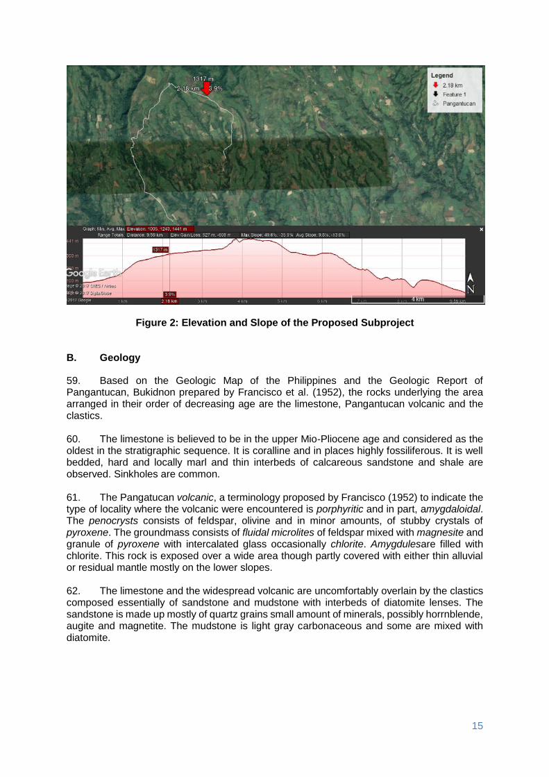
Appendix 1: A copy of the PAMB resolution ........................................................................ 61 Appendix 2: PTTAI PO resolution of support to the subproject ............................................ 62 Appendix 3: Brgy. Concepcion and Brgy. New Eden resolutions of support to the subproject ................................................................................................. 63 Appendix 4: Minutes of the public consultation .................................................................... 65 Appendix 5: Grievance Intake Form .................................................................................... 74

1
I. EXECUTIVE SUMMARY
1. This Initial Environmental Examination has been prepared for the Rural Infrastructure Rehabilitation of New-Eden – Concepcion Access Road and Foot Trails. This Sub-project is the rehabilitation of the existing access road with an estimated length of 5.260 km, width of 4 m. The main proponent of the project is the Local Government Unit of Pangantucan, Bukidnon assisted by Department of Environment and Natural Resources – Integrated Natural Resources and Environmental Management Project. The project implementation will be co-managed by the Municipal Planning and Development Coordinator and the Municipal Engineer. 2. The objective of the Rural Infrastructure – Rehabilitation of New-Eden – Concepcion Access Road and Foot Trails is uplifting the quality of life of the people thru the provision of all-year-round easy and affordable access thereby improving the prompt delivery of basic services, increasing economic opportunities and conditions. The proposed access road and foot trails will support the NRM project activities of the constituents. 3. The Sub-project has been categorized by ADB as Environment Category B and this IEE was prepared consistent with the environmental assessment requirements of ADB’s Safeguard Policy Statement of 2009. The IEE was carried out through screening and analysis of various environmental parameters, field investigations, stakeholder consultations, and review of other road project reports in the Philippines. The IEE covers the general environmental profile of LGU-Pangantucan rural infrastructure sub-project and includes an assessment of the potential environmental impacts during different sub-project phases and formulation of corresponding mitigation measures. The IEE was prepared by the LGU-Pangantucan with the cooperation of RPCO, PMU, WMCO and POs. 4. The total cost of the subproject is Nineteen Million Two Hundred Six Thousand Seven Hundred Sixty Pesos and Sixty-nine centavos (PhP 19,206,760.69). The project funding source is majority coming from the DENR - INREMP and LGU with a cost sharing of 80% and 20%, respectively. It will be assumed that the benefits of the subproject will be the reduction of travel time by 15 minutes, transportation cost by 21.58%, increase number of trips by 50% and availability of infrastructure support for NRM projects and other agricultural livelihood projects of the community.
5. Major land use along the road access and foot trails rehabilitation subproject is agriculture which is part of production forest. The middle section of the proposed subproject is located along the Mt. Kalatungan buffer zone. 6. The IEE, based on the screening of baseline environment and review of proposed civil works, has not identified any major environmental concerns due to proposed rehabilitation of New-Eden – Concepcion Access Road and Foot Trails given that all the proposed civil works are only asset preservation of existing roadway and are located within existing right of way. There will only be localized short-term impacts during construction activities due to implementation of civil works that will be addressed in the detailed design and through implementation of the mitigation and monitoring measures specified in the environmental management plan. The IEE process included stakeholder participation and consultation to help LGUs achieve public acceptance of the Sub-project. A series of consultations with its two influenced

2
7. Barangays (Concepcion and New Eden) of the local government of Pangantucan confirmed that the rehabilitation of New-Eden – Concepcion Access Road and Foot Trails is essential for economic development. 8. A grievance redress mechanism will be established by the LGU of Pangantucan prior to commencement of site works to ensure that complaints of affected persons and other stakeholders regarding the project’s environmental performance are promptly addressed. 9. The IEE includes an environmental management plan which details the mitigation measures, environmental monitoring activities, institutional responsibilities, and environmental management capacity building. The LGU through its Municipal Planning and Development Coordinator and the Municipal Engineer will ensure that relevant EMP provisions are included in bid and contract documents for detailed design, project supervision and civil works. During construction, they will closely conduct monitoring the contractor’s environmental performance and over-all EMP implementation. Semi-annual environmental monitoring reports will be submitted by LGU to ADB and such reports will be posted on ADB’s website for public disclosure. 10. The major positive impact of the project will be economic and better accessibility. The sub-project will directly benefit people located within the two barangays providing improved access and economic development. In relation to the National Greening Program, the proposed road will traverse these NGP areas. The sub-project would also benefit the environment in terms of reduced soil erosion and landslides through slope stabilization measures and construction of retaining structures. Dust generation from the damaged roads will be reduced by the improvement of pavement. Health risk to the roadside communities and damage to the biological environment will be reduced due to pavement improvement and soil erosion control measures.
11. This Subproject will have overall beneficial impact and will have minor negative impacts that will be carefully monitored and adequately mitigated through implementation of the EMP.
II. POLICY, LEGAL, AND ADMINISTRATIVE FRAMEWORK
A. Environmental Clearance Requirements
1. Government Environmental Laws, Regulations and Guidelines
12. According to the EMB Memorandum Circular 005 - 2014, the environmental category of a project is decided based on the type of the project (whether it falls into ‘Environmental Critical Project’, ECP type), location of the project (whether it falls into ‘Environmental Critical Areas’, ECA category), and size of the project. A summary list of ECPs and ECA categories are presented in Table 1.

3
Table 1: Summary List of ECP Types and ECA Categories A. List of ECPs
As declared by Proclamation No. 2146 (1981)
1. Heavy Industries – Non-ferrous Metal Industries, Iron and Steel Mills, Petroleum and Petro-chemical Industries including Oil and Gas, Smelting Plants
2. Resource Extractive Industries – Major Mining and Quarrying Projects, Forestry Projects (logging, major wood processing projects, introduction of fauna (exotic animals) in public and private forests, forest occupancy, extraction of mangrove products, grazing), Fishery Projects (dikes for/ and fishpond development projects)
3. Infrastructure Projects – Major Dams, Major Power Plants (fossil-fueled, nuclear fueled, hydroelectric or geothermal), Major Reclamation Projects, Major Roads and Bridges
As declared by Proclamation No. 803 (1996)
4. All golf course projects
B. List of ECA Categories - As declared by Proclamation No. 2146 (1981)
1. All areas declared by law as national parks, watershed reserves, wildlife preserves, sanctuaries
2. Areas set aside as aesthetic potential tourist spots
3. Areas which constitute the habitat of any endangered or threatened species of Philippine wildlife (flora and fauna)
4. Areas of unique historic, archaeological, or scientific interests
5. Areas which are traditionally occupied by cultural communities or tribes
6. Areas frequently visited and/or hard-hit by natural calamities (geologic hazards, floods, typhoons, volcanic activity, etc.)
7. Areas with critical slopes
8. Areas classified as prime agricultural lands
9. Recharged areas of aquifers
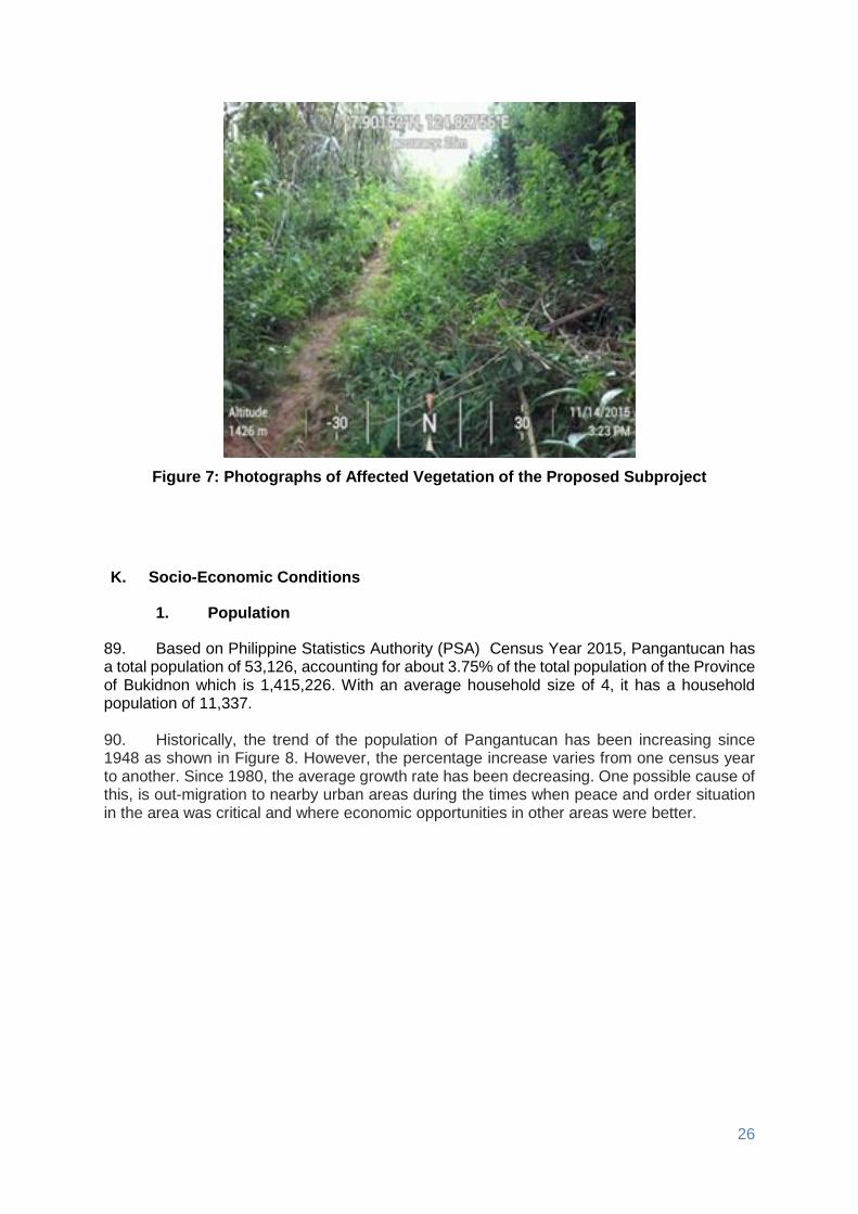
10. Water bodies characterized by one or any combination of the following conditions: tapped for domestic purposes; within the controlled and/or protected areas declared by appropriate authorities; which support wildlife and fishery activities
11. Mangrove areas characterized by one or any combination of the following conditions: with primary pristine and dense young growth; adjoining mouth of major river systems; near or adjacent to traditional productive fry or fishing grounds; areas which act as natural buffers against shore erosion, strong winds and storm floods; areas on which people are dependent for their livelihood.
12. Coral reefs characterized by one or any combination of the following conditions: With 50% and above live coralline cover; Spawning and nursery grounds for fish; Act as natural breakwater of coastlines
13. Based on their type, size and location the projects have been classified into 3 major groups:
• Group I (ECPs): ECPs in either ECAs or NECAs – Environmentally Critical Projects in either Environmentally Critical Areas or Non-Environmentally Critical Areas. These projects require the proponent to submit ‘Environmental Impact Statement’ report to secure ‘Environmental Compliance Certificate’ from DENR’s Environment Management Bureau (EMB). Table 2 gives the size of the road and bridge projects that fall in to Group 1.
• Group II (NECPs): NECPS in ECAs – None Environmentally Critical Projects in
Environmentally Critical Areas. These projects require proponent to submit either ‘Initial Environmental Examination’ Report or ‘Project Description Report ‘ based on the size of the project (see Table 2) to secure either ECC or ‘Certificate of Non Coverage’.
• Group III (Non Covered Projects): NECPs in NECS – Non Environmentally Critical
Projects in Non Environmentally Critical Areas. PDR required to be submitted for Enhancement Mitigation Projects for confirmation of benign nature of proposed

4
activity, and CNC is required to be secured. All other projects shall be at the option of the proponent to prepare a PDR as a basis for CNC, should the proponent opt to secure one.
Table 2: EIS and IEE Requirements for Road and Bridge Projects
Projects within the INREMP Menu of
Subprojects
Covered (Required to secure ECC) Not covered
(may secure CNC) Project size parameters /
Remarks
CATEGORY A: ECP CATEGORY B: Non-ECP CATEGORY D
EIS EIS IEE Checklist Project
Description (Part I only)
3.1Dams, Water
Supply and Flood Control Project
3.1.1DAMS (including those for irrigation, flood control, water source and hydropower projects) including run-of-river type
≥ 25 hectares OR ≥ 20 million m3
>5 hectares but
<25 hectares OR
>5 million m3 but
<20 million m3
≤5 hectares AND
≤5 million m3 NONE
Reservoir flooded/inundated area
or/and water storage capacity
3.1.2Irrigation projects (distribution system only)
NONE
≥1,000 hectares (service
area)
>300 but <1,000
hectares ≤300 hectares Service area
3.1.3 Water Supply Projects (without dam)
NONE
With water source (e.g. infiltration
gallery, etc.) and water treatment facilities including
desalination, reverse osmosis
(RO)
Level III (Distribution system only)
Level II / Level I Water refilling
station
3.4 Roads and Bridges
3.4.2 Roads, widening, rehabilitation and/or improvement
NONE
>50% increase in capacity (or in terms of
length/width) AND
≥20km, (length with no critical slope) OR
≥10km (length with
critical slope)
>50% increase in
capacity (or in terms of
length/width) AND
>2km but <20km,
(length with no critical slope) OR
≥10km (length with critical
slope)
>50% increase in capacity (or in
terms of length/width) BUT ≤
2km increase in length
3.4.3 Bridges and viaducts (including elevated roads), new construction
≥10km ≥5km but <10km
>50m but <5km
≤50m Regardless of
length for footbridges or for pedestrian only
3.4.4 Bridges and viaducts (including elevated roads), rehabilitation and/or improvement
NONE
≥50% increase in capacity (or in terms of
length/width) OR ≥10km
>50% increase in
capacity (or in terms
length/width) but <total length of
10km
≤50% increase in capacity (or in
terms of length/width) but ≤2km increase in
length

5
Projects within the INREMP Menu of
Subprojects
Covered (Required to secure ECC) Not covered
(may secure CNC) Project size parameters /
Remarks
CATEGORY A: ECP CATEGORY B: Non-ECP CATEGORY D
EIS EIS IEE Checklist Project
Description (Part I only)
3.6 Buildings
including Housing, Storage facilities and Other Structures
3.6.2 Storage facilities with no hazardous or toxic materials.
NONE ≥ 5 hectare >1 hectare
but <5 hectare
≤ 1 hectare
Total/gross floor area including parking,
open space and other
areas
14. This subproject is an improvement of existing barangay road which falls under the group of Non-ECP while ADB has categorized the Project as environment Category B. Given that the subproject rehabilitation of New Eden-Concepcion Access Road and Foot Trail, the LGU acquired a Certificate of Non Coverage (CNC) from the Environmental Management Bureau (EMB) Region on September 19, 2016.
2. ADB Environmental Assessment Requirements
15. According to ADB guidelines, the process of determining a project’s environment category is to prepare a Rapid Environmental Assessment screening checklist, taking into account the type, size, and location of the proposed project. Based on ADB’s Safeguard Policy Statement 2009 (SPS 2009), a project is classified as one of the four (4) environmental categories (A, B, C or FI) as follows:
• Category A: Projects with potential for significant adverse environmental impacts that are irreversible, diverse or unprecedented. These impacts may affect an area larger than the sites or facilities subject to physical works. An environmental impact assessment is required.
• Category B: Projects judged to have some adverse environmental impacts, but of
lesser degree and/or significance than those for category A projects. Impacts are site-specific, few if any of them are irreversible, and in most cases mitigation measures can be designed more readily than for Category A projects. An initial environmental examination (IEE) is required.
• Category C: Projects likely to have minimal or no adverse environmental impacts. No environmental assessment is required although environmental implications are still reviewed.
• Category FI: Projects are classified as category FI if they involve investment of funds to or through a financial intermediary. Where the FI’s investment have minimal or no adverse environmental risks. The FI project will be treated as Category C. All other FI’s must establish and maintain an environmental and social management system and must comply with the environmental safeguards requirements specified in SPS 2009 if the FI’s subprojects have the potential for significant adverse environmental impacts.

6
16. According to Philippines environmental guidelines, the Project or Sub-project can be considered as either under Group II or III while ADB has categorized the Project as environment Category B. Hence, this IEE has been prepared to meet the requirements of both the ADB and the government. Upon ADB’s receipt of the final IEE from the proponent, this will be publicly disclosed through posting on ADB’s website.
III. DESCRIPTION OF THE PROJECT
A. Overview
17. Barangay New Eden and Concepcion are adjoining barangays along the foot of Mount Kalatungan and head water of the Muleta River Watershed. These are rural and farming barangays. The New Eden-Concepcion road is an existing access road that traverses along these two (2) barangays leading to Poblacion. 18. Rehabilitation of New Eden-Concepcion access road and foot trail will greatly improve the accessibility within these two (2) barangays. It could also provide alternative route to farmers in marketing their products to other barangays or bringing those products to Poblacion. It will also ensure safety of the people due to the ease of access for responding personnel in case of emergencies. As entry point to Mt. Kalatungan climbers, this particular access road and foot trail is also very useful for eco-tourism endeavours, as part of the Eco-tourism program of the municipality (Mt. Kalatungan being Ancestral Domain of the Manobo and Talaandig Tribe), there is a partnership between the LGU and various Indigenous Peoples (IPs) in the area, as provided for by Ordinance No. 16, series of 2014. Particularly, the IPs serve as tourist guides, and porters, earning an income of 350 and 400 per day, respectively (ratio of 1:10 guide:tourist). 19. To boost economic activity and improve social and infrastructure services in the rural barangays, particularly for Concepcion and New Eden, and the municipality as a whole, the rehabilitation of New Eden-Conception access road and foot trail is deemed timely and necessary to generally lessen the vulnerability of the barangay residents during emergency situations. 20. The Rehabilitation of New-Eden – Concepcion Access Road and Foot Trails is the only existing road directly linking the Barangay New-Eden and Concepcion. Currently, residents from Barangay Concepcion will pass through first barangay Poblacion before reaching Barangay New Eden and it will take them a travel distance of 12.5 km. While using the proposed road section that is directly connecting Barangay Concepcion and Barangay New Eden only take 5.26 km which have a difference of 7.24 km travel distance. 21. Among all road networks of the municipality, this said road section has the worst condition in terms of its physical condition and accessibility compared to other road section within the municipality. The two (2) barangays within the influence area of this road section have large volume of agricultural products such as high value crops and vegetables. To provide ease in transporting these said agricultural products to the market, this road section needs to be given due attention, consideration and priority.

7
A. Project Location 22. The Municipality of Pangantucan is situated along the southwestern border of the province of Bukidnon. It lies within 124° 40’ to 124° 50’ east longitude and 7° 35’ to 7° 55’ north latitude, bounded on the north by the Municipalities of Valencia and Talakag, on the east by the Municipalities of Maramag, Don Carlos and Kadingilan, on the west by the Municipality of Kalilangan, and on the south by Province of North Cotabato. It is approximately 75 km southwest of Malaybalay City, the capital of Bukidnon Province, and is about 166 km southeast of Cagayan de Oro City, the capital of Region 10 (Northern Mindanao). It is composed of 19 barangays, all of which are accessible all year round. 23. Pangantucan has a total land area of 485.84 sq km (48,584 ha), of which, about 52% is currently classified as forestland; the remaining 48% are Alienable and Disposable (A and D) lands. 24. The Municipality’s terrain is characterized by slightly undulating and rolling upland areas, about 62% of which has rolling or hilly terrain within 18% to 50% slope range. Only about 14% of the land area is suitable for agricultural production. On the northwest portion of the municipality is Mt. Kalatungan, the second highest peak in the province with an elevation of 2,824 m asl. Its mountain ranges occupy about 21% of the municipality’s total land area.
B. Project Rationale
25. The Muleta River Watershed is found in the southern portion of the province covering the municipalities of Pangantucan, Don Carlos, Kitaotao, Dangcagan, Kibawe, Kadingilan and Damulog (Figure 1). It is one of the important tributaries of the Pulangi River, which flows southward. It will join the Pulangi River in the boundary of Bukidnon and Cotabato province. The municipality has many water sources with their headwaters from Mt. Kalatungan. Water resources along Mt. Kalatungan vicinity are of critical importance to both natural ecosystem and human development. It is essential for agriculture, industry, and human existence. The healthy aquatic ecosystem is dependent on the physicochemical and biological characteristics. The quality of water in any ecosystem provides significant information about the available resources that support life in that ecosystem. 26. Barangay Concepcion and New Eden are located at the southern foot of the Mt. Kalatungan National Range Park and head water of the Muleta River watershed. The influence area of the proposed RI subproject has farmlands that are cultivated for agricultural crops. Thus, the rehabilitation of the road section will be beneficial to the farmers, and will be easier for them to transport their farm products. 27. Additionally, DENR programs such as INREMP NRM subprojects, and NGP, are located within the influence area; and this proposed rural infrastructure will be a support facility to such DENR subprojects. The Indigenous People Organization (IPO), which is the Portulin Talaanding Tribal Association Inc. (PTTAI), is a recipient of several DENR programs and are also farmers who are actively engaged in farming within the area. 28. Overall, there is a great need to rehabilitate the said road section, in order that the travel time going to the farms will be shortened. Constituents will be encouraged in farming since it will be easier for them to transport their farm products to the market, at a lesser transport cost.

8
Figure 1: The Muleta River Watershed and the location of the Proposed RI Subproject

9
C. Project Development Plan
1. Project Components
29. The scope of works of the road rehabilitation subprojects are the following:
Road graveling
Road concreting
Provision of stone masonry line canal
Provision of RCPCdrains
Provision of riprap stone masonry soil stabilization
Concrete slab for foot trail
30. The 2,850 meters surface gravelling in Barangay New Eden will start from Sta. 00+000 to station 0+600 and Station 1+200 to Station 3+000. The average thickness of surface aggregate to be placed shall be 0.20m on the existing 4 meter-wide barangay road. Placing of surface aggregates shall conform to the requirement of the road during the construction date to achieve standard road level and stability. 31. The station 0+600 to station 1+200 requires road concrete pavement because it is mostly rolling with some critical sections. The average thickness of surface to be placed shall be 6 inches or 150mm on a 4 meter-wide barangay road and 600 meters. 32. Provision of stone masonry line canal from station 0+00 to station 0+600, station 0+600 to station 1+200, station 1+700 to 2+000, station 2+100 to station 3+050, station 3+150 to 3+450. 33. The installation of RCPC Cross Drainage at station 3+580 t0 3+600, station3+660 to 3+675, station 3+700 to 3+720 will be made-up of Reinforced Concrete (RC) and stone masonry. 34. Provision of riprap stone masonry is necessary for slope protection in the site particularly station 3+580 to station 3+600, station 3+660 to station 3+675, and station 3+700 to 3+720. 35. Part of the scope of works is the concrete slab for the foot trail with a total length of 1,810 meters from station 3+460 to station 5+260. 36. The following are the major technical specifications of the project:
Embankment (Item 104) This Item shall consist of the construction of embankment in accordance with the Specification and in conformity with the lines, grades and dimensions shown on the Plans or established by the Engineer.
Structure Excavation (Item 103) This Item shall consist of the necessary excavation for foundation of culverts, cross drains, and other structures not otherwise provided for in the specifications. It shall also include the furnishing and placing of approved foundation fill material to replace unsuitable material encountered below the foundation elevation of structures.

10
Sub-grade Preparation (Item 105) This Item shall consist of the preparation of the subgrade for the support of overlying structural layers. It shall extend to the full width of the roadway. Subgrade preparation shall not be done unless the Contractor is able to start immediately the construction of the pavement structure.
Sub-base Course (Item 200) This item shall consist of furnishing, placing and compacting an aggregate sub-base course on a prepared sub-grade in accordance with the Specification and the lines, grades and cross-sections shown on the Plans, or as directed by the Engineer.
Aggregate Base Course (Item 201) This Item shall consist of furnishing, placing and compacting an aggregate base course on a prepared sub-grade in accordance with this Specification and the lines, grades, thickness and typical cross-sections shown on the Plans. Aggregate for base course shall consist of hard, durable particles or fragments of crushed stone, crushed slag or crushed or natural gravel and filler of natural or crushed sand or other finely divided mineral matter. The composite material shall be free from vegetable matter and lumps or balls of clay, and shall be of such nature that it can be compacted readily to form a firm, stable base.
Surface Course (Item 300) This Item shall consist of furnishing, placing and compacting an aggregate surface course on a prepared base coarse in accordance with the Specification and the lines, grades, thickness and typical cross-sections shown on the Plans, or as established by the Engineer.
Portland Cement Concrete Pavement (Item 311) This Item shall consist of pavement of Portland Cement Concrete, with or without reinforcement, constructed on the prepared base in accordance with this Specification and in conformity with lines, grades, thickness and typical cross-section shown on the Plans.
Pipe Culvert (610mm) (Item 500) This item shall consist of the construction or reconstruction of pipe culverts and storm drains, hereinafter referred to as “conduit” in accordance with this Specification and in conformity with the lines and grades shown on the Plans or as established by the Engineer. Stone Masonry (Item 506) This item shall consist of the construction and establishment of drainage as grouted riprap side ditches in accordance with this Specification and in conformity with the lines and grades shown on the Plans or as established by the Engineer.

11
2. Description of the Project Phases
a. Pre-Construction Phase/Pre-Development Phase 37. This phase would involve the social preparation (to include organizational strengthening, planning, identification and prioritization of community needs) of the community for the entry of the project to the site, conduct of pre-engineering activities covering detailed survey works to determine alignment of roads and canal systems, preparation of the detailed engineering plans and programs of work, ROW negotiation, recruitment of work force and initial sourcing and procurement of construction materials. These activities will be conducted by the proponent technical staff, partner line agencies, NGO service providers, community beneficiaries especially the Indigenous People and contractors.
b. Construction/Development Phase 38. This phase would involve the mobilization of construction equipment, construction workers and materials to the specific subproject site after which the longer period of actual construction work will commence. The construction phase will end up with the demobilization of construction equipment, workers and other construction paraphernalia from the construction site. Majority of these activities will be undertaken by the contractor and community beneficiaries under the close supervision of the SPMU most especially by the municipal Engineering Unit.
c. Operation Phase and Maintenance Phase 39. This phase involves the actual maintenance of the rehabilitated access road during its expected economic life. Monitoring tools and parameters will be set forth in the MOA that the LGU and DENR will sign to ensure sustainability of the constructed facility. The specific monitoring items and parameters, location and frequency, monitoring responsibilities and sources of budget are presented in the EIAMMP as attached.
d. Abandonment Phase
40. This phase is included in the project demobilization. The proponent does not intend to abandon any facilities and unserviceable equipment used during construction. The project location will not be abandoned in disorderly condition but instead restored for functional use. Following the completion of the construction, the proponent will dismantle temporary shelters and the construction yard including unserviceable vehicles and equipment.
41. Wastes arising from the abandonment are expected to be minimal. These wastes could include small volumes of left over sand and gravel, re-bars and other construction materials and lumber. D. Manpower Requirements
42. Construction activities will require hiring of skilled and unskilled manpower. It is assumed that some skilled, semi-skilled and unskilled manpower will be available in the area. Skilled manpower not available in the locality may be sourced from other nearby localities. Technical manpower will be a complementation of specialists to be provided by locally known engineering firms.
12
43. During the construction phase, a workforce consisting of contractual and regular laborers will be employed to carry out the construction of the proposed project. 44. The Contractor shall employ qualified and sufficient staff to carry out inspections, testing and monitoring for the project. E. Project Cost
45. The propose RI project has a total cost of Nineteen Million Two Hundred Six Thousand Seven Hundred Sixty Pesos and Sixty-Nine centavos (PhP 19,206,760.69). The INREMP grant will be Fifteen Million Three Hundred Sixty-Five Thousand Four Hundred-Eight Pesos and Seventy-three Centavos (PhP 15,365,408.73) and the LGU counterpart will be Three Million Eight Hundred Forty-One Thousand Three Hundred Fifty-two Pesos and Eighteen centavos (PhP 3,841,352.18). The LGU equity will be taken from its 20% development fund stipulated in its annual budget.
46. The estimated cost of the proposed subproject is PhP 19,206,522.69. Breakdown of cost estimates is presented in (Table 3).
Table 3: Breakdown of Cost Estimates for the Road Rehabilitation Project
47. The source of fund for the project will come from National Government and Local Government Unit with a cost sharing of 80% and 20%, respectively. The total project costs of PhP 19,206,522.69 will be utilized for direct cost (materials, equipment and labor) with the amount of PhP 15,449.262.14, indirect cost (contractor’s’ profit, OCM and VAT) of PhP 3,757,260.55.
kms.
Project Description:
calendar days
A.
102 0.05 8759.358 cu.m. 152.98 804,686.78
104 0.01 1643.717 cu.m. 18.05 94,968.40
103 1.39% 2,150.30 cu.m. 61.25 215,030.40
105 Subgrade Preparation 1.22% 13,200.00 sq.m. 14.32 189,077.04
B.
200 Aggregate Subbase Course 23.61% 2,277.00 cu.m. 1,602.18 3,648,160.12
300 16.75% 1,863.00 cu.m. 1,201.56 2,588,235.00
C.
311.A 16.75% 360.00 cu.m. 6,218.07 2,588,235.00
311.B 3.06% 9,701.00 kgs 63.95 473,406.00
311.C 5.78% 3,110.00 pcs 287.12 892,930.67
E. DRAINAGE & SLOPE PROTECTION STRUCTURE
500(1) RCPC, 910mm ø 0.92% 28.00 lin.m. 5,094.27 142,711.88
505(5) 2.16% 187.00 cu.m. 2,333.88 333,055.00
22.14% 1,575.00 cu.m. 2,845.55 3,420,137.90
506 0.38% 978.00 cu.m. 3,492.09 58,627.96
100.00% 15,449,262.14
LGU ( 20% )
A. Direct Cost 15,449,262.14
B. Indirect Cost 3,757,260.55
OCM 9% OF Direct Cost 463,477.86
Contractor's Profit 8% OF Direct Cost 1,235,940.97
VAT 12% ( DC + OCM +CP ) 2,057,841.72
C. Project Cost (Total A + B) 3,841,304.54 19,206,522.69
Say ,Estimated Project Cost (EPC)
D. PERCENTAGE
Rehabilitation of New Eden-
Canal Lining
Fabrication of Concrete Slab
Headwalls
Grouted Riprap
Project Title: Rehabilitation of New Eden- Concepcion Access Road and Foot Trail
Category Rural Access (Road Rehabilitation/Improvement)
Physical Target
Brgy/Mun/Province Brgy. New Eden / Pangantucan/ Bukidnon
Total Project Cost
Implementation Mode By Contract
Project Duration
Equipment Needed Dozer/Grader/R.
Technical Personnel Civil
Item No. Scope of Work % Weight Quantity Unit Unit Cost
Breakdown of Estimated Project CostSOURCE OF FUND
Total CostINREMP ( 80% )
Total
EARTHWORKS
SURFACE COURSE
SURFACE COURSE
Installation of Concrete Slab
Total Project Cost
Embankment
Excavation
Structure Excavation
Aggregate Surface Course
PCCP
15,365,218.16

13
48. The Local Government of Pangantucan has the capacity to provide counterpart for INREMP Rural Infrastructure. During the budgeting for 2016, the LGU has allocated a total of Php 3,841,352.18 from its Local Development Fund.
49. Aside from the equity counterpart provided by the LGU Pangantucan for the subproject, they also allocated some amount intended for the preparation of the project such as seminars, preparation of feasibility study (or subproject proposal document) and detailed engineering, survey of the project site and some evaluation by the personnel from different sectors who will be involved in the implementation of the subproject.
F. Project Duration and Schedule
50. The timetable for the subproject implementation is expected to reach a total of 365 calendar days. It is projected that the preparation of Detail Engineering Design (DED) will also be completed by end of December 2017. After the DED is translated into standard bidding document (SBD), procurement activities for civil works is projected to proceed, starting April 2018 through national competitive bidding (NCB). Advertisement, opening of bids, bid evaluation and award of contract is expected to take at least 28 days. 51. Rehabilitation period is estimated to cover 365 calendar days. Physical completion, including the completion of documentary requirements, is expected by end of January 2019. The matrix below shows the major stages of implementation and respective timeline (Table 4).
Table 4: Implementation Schedule
2017 2018 2019
RI Subproject Milestones <N D J F M A M J J A S O N D J F
SPD Preparation
Final Review of SPD
SPD Approval
DED Preparation
Procurement Stage
Construction Stage
Completion and Turn-over
O&M Activities
IV. DESCRIPTION OF THE ENVIRONMENT
52. The Muleta River Watershed is found in the southern portion of the province covering the municipalities of Pangantucan, Don Carlos, Kitaotao, Dangcagan, Kibawe, Kadingilan and Damulog. It is one of the important tributaries of the Pulangi River, which flows southward. It will join the Pulangi River in the boundary of Bukidnon and Cotabato province.The municipality has many water sources with their headwaters from Mt. Kalatungan. Water resources along Mt. Kalatungan vicinity are of critical importance to both natural ecosystem and human development. It is essential for agriculture, industry, and human existence. The healthy aquatic ecosystem is dependent on the physicochemical and biological characteristics. The quality of water in any ecosystem provides significant information about the available resources that support life in that ecosystem.

14
53. Barangays Concepcion and New Eden are located at the Southern foot of the Kalatungan National Range Park and head water of the Muleta River watershed.
54. Barangay Concepcion’s land area is about 2,719 hectares. The types of soil is from sandy to clay. It is bounded by Talakag in the North, Poblacion and Adtuyon in the South, New Eden in the East, and Mendis in the West.
55. Barangay New Eden has a total land area of about 1,015 hectares. Based on soil texture distribution of the barangay, about 10% are clay, 44% are loam, 5% are sandy, 19% are clay loam and 22% are sandy loam. The barangay is about 7 km from the central Poblacion of Pangantucan. It is bounded in the north by the municipality of Talakag, in the south by barangay Adtuyon, in the east by barangay Portulin, and in the west by barangay Concepcion. A. Elevation and Slope
56. The municipality of Pangantucan has about 21% are mountain ranges, while about 61% are hilly or rolling terrain. The remaining area is relatively flat, fit for agricultural production. The elevation of Pangantucan ranges from 252 m to 2,824 m above sea level (m asl) with the highest point at the peak of Mt. Kalatungan. Around 40% of the area has an altitude of 1,000 m especially, within the Mt. Kalatungan range. The rest of the area lies within the 252 to 1,000-meter altitude. 57. The terrain of Pangantucan is characterized by slightly undulating and rolling upland areas (Table 5). Only 4.81% of the total area is relatively flat, with slope-range of 0 to 3%. A large portion of the land, however, has slopes ranging from 18% to 50% and above.
Table 5: Slope Range Classification Slope Range (%) Area (ha) Percent of Total (%)
0-3 3-8
8-18 18-36 36-50
50 above
2,337.5 5,912.5
5,792.5 12,284.1 10,066.3 12,191.4
4.8 12.2 11.9 25.3 20.7 25.1
Total 48,584.2 100 Source: MPDO (2015)
58. In particular, the proposed subproject has an elevation ranging from 1,005 to 1,243 m asl with an average slope of 9.6%. Other details are shown in Figure 2.
15
Figure 2: Elevation and Slope of the Proposed Subproject B. Geology
59. Based on the Geologic Map of the Philippines and the Geologic Report of Pangantucan, Bukidnon prepared by Francisco et al. (1952), the rocks underlying the area arranged in their order of decreasing age are the limestone, Pangantucan volcanic and the clastics.
60. The limestone is believed to be in the upper Mio-Pliocene age and considered as the oldest in the stratigraphic sequence. It is coralline and in places highly fossiliferous. It is well bedded, hard and locally marl and thin interbeds of calcareous sandstone and shale are observed. Sinkholes are common.
61. The Pangatucan volcanic, a terminology proposed by Francisco (1952) to indicate the type of locality where the volcanic were encountered is porphyritic and in part, amygdaloidal. The penocrysts consists of feldspar, olivine and in minor amounts, of stubby crystals of pyroxene. The groundmass consists of fluidal microlites of feldspar mixed with magnesite and granule of pyroxene with intercalated glass occasionally chlorite. Amygdulesare filled with chlorite. This rock is exposed over a wide area though partly covered with either thin alluvial or residual mantle mostly on the lower slopes.
62. The limestone and the widespread volcanic are uncomfortably overlain by the clastics composed essentially of sandstone and mudstone with interbeds of diatomite lenses. The sandstone is made up mostly of quartz grains small amount of minerals, possibly horrnblende, augite and magnetite. The mudstone is light gray carbonaceous and some are mixed with diatomite.

16
C. Soil 63. Generally, the soil of Muleta Watershed consists mostly of Adtuyon clay Kidapawan clay, Macolod clay and mountain soil (Table 6). Adtuyon clay has the largest area coverage. Its coverage encompasses middle portion of the watershed where six municipalities are situated. On the other hand, the sub-watersheds are characterized by Kidapawan clay except for Apulang River in southwestern portion where the soil type is Macolod clay. 64. All these series were developed from parent materials that originated from the volcanic lava. These types of soils are called zonal soils owing to the combined effects of climate and vegetation on various rocks which have lived in a well-drained position long enough for dynamic equilibrium to be reached between the delay and accumulation of organic matters and between the rates of erosion and rock weathering.
Table 6: Soil Series Type within the Muleta Watershed
Soil Series Type Total
Adtuyan clay 17,664
Faraon clay 1,689
Kidapawan clay; Kidapawan clay loam 25,218
La Castellana clay loam 5,850
Macolod clay 21,153
Mountain soil (undifferentiated) 4,740
Tacloban clay 1,522
Grand Total 77,837 Source: Bureau of Soil and Water Management, 1996
D. Water quality 65. The proposed rural infrastructure subproject is the rehabilitation of New Eden – Concepcion access road and foot trail which is located at Barangay New Eden and Sitio Tagolilong, Barangay Concepcion, Municipality of Pangantucan, Province of Bukidnon. The Barangay is one of the beneficiaries of the Integrated Natural Resources and Environmental Management Project for the municipality since the Muleta River traverses the barangay boundary. The proposed access road and foot trail will link to municipal watershed subprojects since the RI subproject will start at the municipal boundary of Maramag, Don Carlos, Kadingilan and Valencia which is the Muleta River. 66. In addition, the proposed access road subproject is passing across the Pulangi river which is one of the tributaries of the Muleta Watershed. The Pulangi river has still no water classification pursuant to DAO No. 34, Series of 1990 and DENR Memorandum Circular No. 09, Series of 2001. In the absence of water classification and in accordance with the Manual of Procedure for Water Classification, the Pulangi river is assumed to be a Class A waters since most of the upstream stations are under this classification. A “Class A” waters intended beneficial use is public water supply class which is usually sources of water supply that will require complete treatment (coagulation, sedimentation, filtration, and disinfection) in order to meet the National Standards for Drinking Water. 67. The Watershed Management Plan (2015) described the water quality conditions of the Muleta Watershed which was based on DAO 34-1990. The description is only limited to the following parameters:
The Muleta Watershed mean temperature is 27°C which indicates that the water in the watershed is within the normal range for surface water.

17
Average pH value of 8.4 taken from different monitoring points showed that the water quality of Muleta watershed conformed to the set standard (6.5 – 8.5) as pH is an important limiting chemical for aquatic life.
Biochemical Oxygen Demand (BOD) in Muleta watershed has an average value of 1 mg/L and still within the set standard (5 mg/L), which means minimum degree of pollution strength of domestic and industrial wastes or has low in purification capacities of bodies of waters in receiving organic wastes.
Dissolved Oxygen (DO) levels range from 5.5 to 7.7 mg/L - ) which is still above the minimum set standard for Class A water (minimum of 5 mg/L.
Phosphate level of the Muleta Watershed is about 0.30 mg/L which is above the set standard (0.1 mg/L).
The fecal coliform based on the existing monitoring station in the Muleta watershed is 780 MPN/100 mL which is higher than the set minimum standard of 100 MPN/100 mL.
E. Land Classification
68. Pangantucan has a land area of about 48,584 ha, which is the 9th largest among the 20 municipalities of Bukidnon and two (2) cities of the province. Of the total land area, about 53% or about 257.57 ha is currently classified as forestland, while about 47% or 228.27 ha is A and D lands. 69. About 29 % of the 53 % of forestland, is a production area, where DENR subprojects are located, such as; National Resources Management (NRM), Reforestation, and National Greening Program (NGP), where the communities are the direct beneficiaries. 70. Barangay Concepcion has a total land area of about 2,673 ha, and about 97% or about 2,598 ha is classified as forestland, and about 3% or 75 ha is classifies as A and D (Table 7). Barangay New Eden has a total land area of about 947 ha, 60% or 567 ha is classified as forestland, and about 40% or about 380 ha is classified as A and D. Table 2 shows the land area by barangay per classification. 71. It must be noted that the proposed road access rehabilitation in Pangantucan is within the public land as shown in Figure 3. In addition, the proposed subproject does not fall within the Protected Area or Special Area for Protecting Biodiversity of the Mt. Kalatungan Range Natural Park. The subproject covers about 5.0 km, wherein the length of the foot trail for proposed rehabilitation is only 1.81 km. As shown in Figure 4, only about 80 m of the said foot trail runs along the edge of the Buffer Zone. Hence, the LGU of Pangantucan has requested a certificate to the Protected Area Management Board of the DENR Region 10 that the access road and foot trail to be rehabilitated under INREMP, have long been in existence and needs to be improved for efficient protection and monitoring purposes (Appendix 1).
F. Land Cover and Land Use
72. Table 8 shows the distribution of major land use by municipality within the watershed. In terms of annual crops, the Don Carlos has the biggest area coverage (5,023 ha) while Damulog has the smallest area (864 ha). Closed forests are locally found in Pangantucan, Valencia and Talakag.

18
Table 7: Land Area by Barangay per Land Classification
Table 8: Land - Use by Municipality
Municipality
Area (ha)
Annual Crop
Built-up
Closed Forest Grassland
Inland Water
Perennial Crop Shrubs
Wooded grassland
Grand Total
Carmen 1,840 31.38 517.00 19.37 64 2,382 4,855
Damulog 864 135.78 20.21 6,724.09 4,566 12,310
Dangcagan 4,226 141.88 35.66 4,404
Don Carlos 15,023 397.72 36.29 6 184 15,646
Kadingilan 2,525 58.31 28.78 180.05 4,853 7,645
Kibawe 3,825 220.22 4,906.33 84 9,036
Kitaotao 3,772 114.58 3,886
Maramag 3,503 53.10 1,391.24 144 5,091
Pangantucan 13,915 361.63 3,170 308.21 34.70 621.83 494 18,906
Talakag 402 63.37 465
Valencia City 577 11.44 1,046 1,634
Grand Total 50,076 1,526 4,618 2,316 83 12,487 563 12,213 83,884
Barangay Total Area (ha) A and D (ha) Forestland (ha)
Adtuyon Bacusanon Bangahan Barandias Concepcion Gandingan Kimanait Kipaducan Langcataon Lantay Madaya Malipayon Mendis Nabaliwa New Eden Payad Pigtauranan Poblacion Portulin
2876 4568 2030 1566 2673 6259 1489 2369 1015 2098 1049 1861 2740 4264 947 1218 3722 1692 4737
2689 2425 1560 1317 75
1753 562 600 58
1400 900 230 150 1808 380 703 418 1022 1000
187 2143 470 249 2598 4506 927 1769 957 698 149 1631 2591 2456 567 515 3304 670 3737
Total 49,174 19,050 30,124 Source: CLUP

19
Figure 3: Land Classification of the Pangantucan, Bukidnon

20
Figure 4: Location of the Proposed Road and Foot Trail along the Buffer Zone

21
73. The proposed road rehabilitation and foot trail subproject is traversing within the agricultural lands (i.e. cassava, sugarcance, banana), grassland, and forest land. Again, there are seven (7) households who are informal settlers in Barangay New Eden, Pangantucan, Bukidnon. The informal settlers are not found near the subproject site and they will be not affected when the project is implemented. In addition, it must be noted that there are no trees and other assets encroachment at the easement affected during the construction’s right of way. The road and foot trail rehabilitation is based on the existing road access. G. Climate
1. Base Climate
74. The province of Bukidnon climate falls under Type III and IV of the Modified Corona’s Climate Classification System (Agpaoa et al., 1975). The western portion is classified under Type III which is characterized by a short dry season, usually from February to April, and Type IV climate in the eastern part, characterized by an almost evenly distributed rainfall during the whole year. 75. Records from PAGASA shows that total annual average rainfall for the period of 1981-2010 is 1,703 mm. Further, PAGASA reveals that from June to November, which is rainy season, the average rainfall per month is 184 mm. From December to May, which is dry season, the average rainfall per month is 95 mm.
76. Meanwhile, the area has an annual mean temperature of 26.8 °C while the average relative humidity is 81%. The hottest months are April, May, and June while the coldest months are December, January, and February. These observations were obtained from the nearest PAGASA station in Lumbia Airport.
77. The southwest and the northeast monsoon systems influenced the rainfall pattern that is responsible for the tropical storms that batter the entire region during the rainy season. The southwest monsoon sets in during late May and peaks during the months of November and December (Figure 5). The northeast monsoon then comes in during late October and intensifies in January and February. Overall, the area is seldom visited by storms and/or typhoons. From 1948 to 2009, only one tropical storm and one typhoon passed through the Province of Bukidnon, which affected the area. On average, the area is visited by 2 typhoons per year. It is during January and October when a number of cyclones would cross the watersheds whereas the remaining months are almost free of tropical cyclones.
1. Climate scenario for Bukidnon Province in 2020 and 2050
78. PAGASA-DOST projected the climate changes using the CNCM3 model scenarios. Based on projections, the province will be affected by changes in rainfall in various seasons, and increasing occurrences of extreme events in 2020 and 2050. The projected monthly rainfall change in 2020 and 2050 under the CNCM3 model scenario in the province are presented in (Table 9). 79. The simulated monthly rainfall ranges from 71 mm to 626 mm. The mean monthly rainfall of two scenarios (A1B and A2) was significantly different from each period. The driest month, April, still sees below 150 mm of precipitation per month. The wettest months are November and December with a monthly mean of more than 300 mm (Figure 6). 80. In particular, the monthly precipitation fluctuated each month for two periods. However, the most distinct changes are predicted to be in the 2050s period under A2 scenario where

22
most likely longer dry months. Other periods closely followed the trends and patterns. Overall, a decrease of annual rainfall was predicted in each scenario for two periods as much as 40% compared to the observed scenario (Table 10).
Figure 5: Record of Tropical Cyclones that Passed through the Region Covering the
Influence Watersheds during the Period 1948 - 2009 (PAGASA)
Table 9: Projected monthly rainfall based on CNCM3 model with A1b and A2 scenarios for 2020s and 2050s periods in Bukidnon Province
Month Observed A1B A2
2020 2050 2020 2050
Jan 295.5 335.7 160.6 290.1 206.9
Feb 224.1 390.4 106.1 116.9 197.6
Mar 190.4 200.0 106.4 196.5 191.0
Apr 148.3 66.5 108.6 132.9 99.5
May 208.9 304.0 261.9 176.5 98.9
Jun 278.9 167.5 311.1 271.7 71.2
Jul 337.7 146.6 368.8 335.8 97.0
Aug 378.4 391.4 412.0 208.6 128.5
Sep 236.4 226.6 271.6 333.4 176.2
Oct 273.2 132.8 271.8 366.6 207.6
Nov 314.2 456.9 304.8 274.4 285.5
Dec 436.7 626.2 351.5 382.4 204.8
Total 3322.7 3444.6 3035.1 3085.9 1964.5
Min 148.3 66.5 106.1 116.9 71.2
Max 436.7 626.2 412.0 382.4 285.5
SD 82.21 161.18 107.73 89.91 63.93
Ave 276.9 287.1 252.9 257.2 163.7

23
Figure 6: Monthly rainfall based on CNCM3 model for 2020s and 2050s periods in
Bukidnon Province
Table 10: Change anomalies of rainfall in Bukidnon Province based on CNCM3 model
Month A1B A2
2020 2050 2020 2050
Jan 13.6 -45.7 -1.8 -30.0
Feb 74.2 -52.6 -47.8 -11.8
Mar 5.0 -44.1 3.2 0.3
Apr -55.1 -26.8 -10.4 -32.9
May 45.5 25.4 -15.5 -52.7
Jun -39.9 11.5 -2.6 -74.5
Jul -56.6 9.2 -0.5 -71.3
Aug 3.4 8.9 -44.9 -66.0
Sep -4.2 14.9 41.0 -25.5
Oct -51.4 -0.5 34.2 -24.0
Nov 45.4 -3.0 -12.7 -9.1
Dec 43.4 -19.5 -12.4 -53.1
Total 3.7 -8.7 -7.1 -40.9
I. Natural Hazards
81. The extreme weather event experienced within Muleta watershed was the cold front and typhoons Sendong and Pablo in the year 2011 and 2012. The occurrence of typhoons results to flooding in some part of the watershed specifically at Purok 3, Brgy. Malinao, Kadingilan, Brgy. Cabadiangan, Don Carlos, and Sitio Lumagwas, Brgy. Adtuyon, Pangantucan, all in Bukidnon. 82. In general, the country experiences an average of 20 typhoons and most of which pass through Visayas and Luzon every year. Situated close to what could be the southernmost rim of the Philippine typhoon belt, the province received 11 typhoon hits over a 20-year period (Table 11). The floods of 2009 and 2011 have already provided a tragic illustration of what can happen. While the province is free from the direct effects of tropical cyclone, its weather,
0.0
100.0
200.0
300.0
400.0
500.0
600.0
700.0
Jan Feb Mar Apr May Jun Jul Aug Sep Oct Nov Dec
Mo
nth
ly R
ain
fall
(mm
)
Observed 2020 (A1B) 2050 (A1B) 2020 (A2) 2050 (A2)

24
particularly manifestation of rainfall may be affected by tropical cyclones passing close to the northeastern tip of Mindanao (UN-HABITAT and WFP, 2013).
Table 11: Total Annual Number of Typhoons in the Area
Year Tropical Cyclone Period
Durations (days) Begin Date End Date
1991 TS Bebeng 4/23/91 4/26/87 4
1993 TD Bining 4/12/93 4/13/93 2
1993 TY Toyang 12/24/93 12/29/93 6
1996 TD Toyang 11/4/96 11/13/96 10
2002 TD Caloy 3/20/02 3/23/02 4
2003 TD Zigzag 12/24/03 12/27/03 4
2004 TD Pablo 9/15/04 9/17/04 3
2007 TY Lando 11/19/07 11/28/07 10
2008 TS Ambo 4/14/08 4/15/2008 2
2008 TD Rolly 11/8/08 11/09/2008 2
2008 TD Tonyo 11/13/08 11/16/2008 4
2011 TY Sendong 12/15/11
Source: WWF-BPI Business Risk Assessment as cited by UN-HABITAT, 2013
H. Biological Environment
1. Flora and Fauna
83. A portion of Mt. Kalatungan range is part of Muleta watershed in which its headwater emanates. This forested mountain range is habitat of various plant species and wild animals. The whole area is still rich in biodiversity that includes plants, reptiles, amphibians, and birds. Table 12 shows the summary of flora and fauna in the area.
Table 12: Summary of Flora and Fauna within the Watershed Flora No. of Species
Tress and Arborescent 173
Herbs and Herbaceous 115
Shrubs and Bushes 37
Vines and Scandent 35
Ferns 17
Palms 12
Subtotal 389
Fauna No. of Species
Mammals 7
Birds 67
Amphibians and Reptiles 16
Subtotal 90
Total 479
Source: Berkman Systems, Inc. (EIS Pulangi Hydroelectric Power Plant) (As cited in Lower Pulangi Watershed Management Area of the Rio Grande de Mindanao River Basin Management Framework Plan, 2014)

25
84. Biodiversity in the area is monitored by the PASO Kalatungan through Biodiversity Monitoring System (BMS). Bantay Lasang was deployed by PASO to monitor the area and for law enforcement specifically in the apprehending unregulated hunting of wildlife and unauthorized cutting of trees. The honorarium of the Bantay Lasang is shouldered by the PASO with a counterpart of the LGU where the PA strides.
85. To monitor the Mt. Kalatungan Range Natural Park, PASO Kalatungan conducted a quarterly BMS which includes Focus Group Discussion among the community adjacent to the park to identify issues within the park. Based on the result of FGD, major treats of Mt. Kalatungan as unique natural attraction is the wildlife hunting and extraction of flora like Nito(Small rattan), Abaca, Anibong, Banag for commercial, food, roofing and medicine purposes.
86. Within the watershed area lies Mt. Kalatungan which is considered as the 5th highest peak in the country, it has been declared an Important Bird Area (IBA) in 2001 for it is home to the Philippine Eagle (Pithecophaga jefferyi) and Philippine Hawk-Eagle (Nisaetus philippensis) which is locally known as “Kalumbata”. 87. The proposed road access rehabilitation subproject is within the Muleta Watershed Forest Reserve. At the middle portion, the alignment of the proposed road access is about 0.7 km away from Mount Kalatungan Range Natural Park. 88. Based on the field validation conducted on November 11, 2016 by the LGU, PPMO, RPCO and NPCO technical staff together with its consultants, there are no trees, no endangered and critically endangered species of fauna along the road and foot trail right of way (Figure 7). However, there will be a small portion of the crops (sugarcane, banana, cassava) that may be affected due to a minor land encroachment along the right of way of the proposed access road and foot trail.
26
Figure 7: Photographs of Affected Vegetation of the Proposed Subproject
K. Socio-Economic Conditions
1. Population
89. Based on Philippine Statistics Authority (PSA) Census Year 2015, Pangantucan has a total population of 53,126, accounting for about 3.75% of the total population of the Province of Bukidnon which is 1,415,226. With an average household size of 4, it has a household population of 11,337. 90. Historically, the trend of the population of Pangantucan has been increasing since 1948 as shown in Figure 8. However, the percentage increase varies from one census year to another. Since 1980, the average growth rate has been decreasing. One possible cause of this, is out-migration to nearby urban areas during the times when peace and order situation in the area was critical and where economic opportunities in other areas were better.

27
Figure 8: Historical Growth of Population
2. Influence Area Population
91. Based on the Community Based Monitoring System (CBMS) 2015 the influence area Barangays Concepcion and New Eden, has a total household of 442 and a population of 1,979 (1,046 males and 933 females). Table 13 shows the population of the influence barangays.
Table 13: Population of Barangay Concepcion and New Eden, Pangantucan
Barangay
Households Population
No. of HH Average HH size
HH Member HH Member Percentage
Total Male Female Total Male Female
Concepcion 180 5 850 463 387 100 54.5 45.5
New Eden 262 4 1129 583 546 100 51.6 48.4
TOTAL 442 1,979 1,046 933 Source: CBMS 2015-2016
92. Table 14 shows the number of the labor force in the influence area (i.e., total population of 631, where 394 are males and 237 are females). Specifically, Barangays Concepcion and New Eden have a labor force of 26%, and 30% of their total population, respectively.
Table 14: Member of the Labor Force
Barangay
Households Population
No. of HH Percentag
e
HH Member HH Member Percentage
Total Male Female Total Male Female
Concepcion 145 55.3 295 153 142 26.1 26.2 26
New Eden 214 81.7 336 241 95 29.8 41.3 17.4
TOTAL 359 631 394 237 Source: CBMS 2015-2016
1,869
12,356
17,458
24,734
29,065
35,77738,418
43,20246,689
53,126
0
10,000
20,000
30,000
40,000
50,000
60,000
1948 1960 1970 1975 1980 1990 1995 2000 2007 2015
Historical Growth of Population

28
93. The age and sex desegregation in the influence area, Barangays Concepcion and New Eden is presented in tabular form, as shown in Table 15.
Table 15: Age and Sex Desegregation
Barangay
Households Population
No. of HH Percentage HH Member HH Member Percentage
Total Male Female Total Male Female
Concepcion
Children under 1 year old
31 17.2 32 21 11 3.8 4.5 2.8
Children under 5 years old
101 56.1 149 84 65 17.5 18.1 16.8
Children 0-5 years old
108 60 169 96 73 19.9 20.7 18.9
Children 6-11 years old
80 44.4 110 56 54 12.9 12.1 14
Children 6-12 years old
84 46.7 127 65 62 14.9 14 16
Members 12-15 years old
54 30 71 41 30 8.4 8.9 7.8
Members 13-16 years old
56 31.1 72 42 30 8.5 9.1 7.8
Members 6-15 years old
96 53.3 181 97 84 21.3 21 21.7
Members 6-16 years old
101 56.1 199 107 92 23.4 23.1 23.8
New Eden
Children under 1 year old
30 11.5 31 14 17 2.7 2.4 3.1
Children under 5 years old
112 42.7 157 73 84 13.9 12.5 15.4
Children 0-5 years old
124 47.3 182 90 92 16.1 15.4 16.8
Children 6-11 years old
113 43.1 157 74 83 13.9 12.7 15.2
Children 6-12 years old
118 45 180 86 94 15.9 14.8 17.2
Members 12-15 years old
82 31.3 112 66 46 9.9 11.3 8.4
Members 13-16 years old
85 32.4 115 67 48 10.2 11.5 8.8
Members 6-15 years old
140 53.4 269 140 129 23.8 24 23.6
Members 6-16 years old
145 55.3 295 153 142 26.1 26.2 26
Source: CBMS 2015-2016
3. Poverty Threshold
94. The CBMS data on 2015-2016 annual capita poverty thresholds is PhP 22,367.00. The Poverty threshold means that one member of the household needs at least 22,367.00 pesos a year in order to provide for basic needs such as food, shelter, clothing, education, etc. This implies that a household composed of four (4) members will need an annual income of PhP 89,468.00, to meet all basic needs. 95. Around seventy-five % (75%) or 8,446 households out of the 11,337 households live below the poverty line. Table 16 below shows the poverty threshold per barangay.
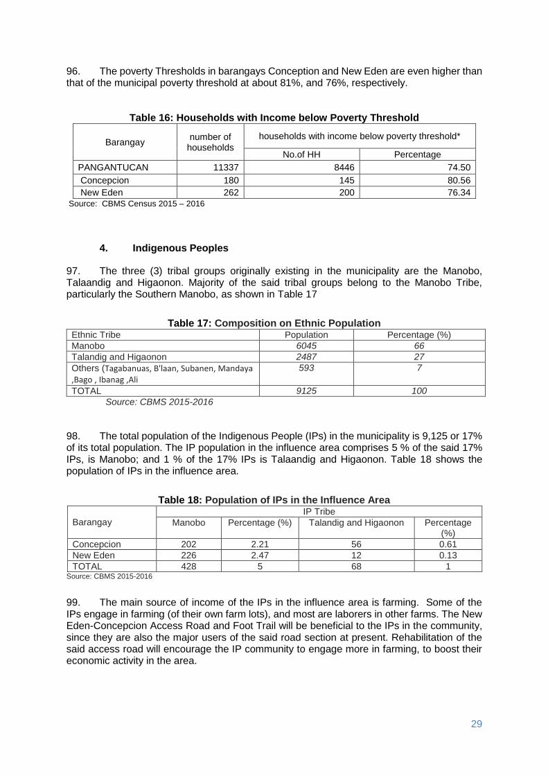
29
96. The poverty Thresholds in barangays Conception and New Eden are even higher than that of the municipal poverty threshold at about 81%, and 76%, respectively.
Table 16: Households with Income below Poverty Threshold
Barangay number of
households
households with income below poverty threshold*
No.of HH Percentage
PANGANTUCAN 11337 8446 74.50
Concepcion 180 145 80.56
New Eden 262 200 76.34
Source: CBMS Census 2015 – 2016
4. Indigenous Peoples
97. The three (3) tribal groups originally existing in the municipality are the Manobo, Talaandig and Higaonon. Majority of the said tribal groups belong to the Manobo Tribe, particularly the Southern Manobo, as shown in Table 17
Table 17: Composition on Ethnic Population Ethnic Tribe Population Percentage (%)
Manobo 6045 66
Talandig and Higaonon 2487 27
Others (Tagabanuas, B'laan, Subanen, Mandaya ,Bago , Ibanag ,Ali
593 7
TOTAL 9125 100
Source: CBMS 2015-2016
98. The total population of the Indigenous People (IPs) in the municipality is 9,125 or 17% of its total population. The IP population in the influence area comprises 5 % of the said 17% IPs, is Manobo; and 1 % of the 17% IPs is Talaandig and Higaonon. Table 18 shows the population of IPs in the influence area.
Table 18: Population of IPs in the Influence Area
Barangay IP Tribe
Manobo Percentage (%) Talandig and Higaonon Percentage (%)
Concepcion 202 2.21 56 0.61
New Eden 226 2.47 12 0.13
TOTAL 428 5 68 1 Source: CBMS 2015-2016
99. The main source of income of the IPs in the influence area is farming. Some of the IPs engage in farming (of their own farm lots), and most are laborers in other farms. The New Eden-Concepcion Access Road and Foot Trail will be beneficial to the IPs in the community, since they are also the major users of the said road section at present. Rehabilitation of the said access road will encourage the IP community to engage more in farming, to boost their economic activity in the area.

30
5. Civil Society Organization
100. The Civil Society Organization (CSO) comprises different organizations, as follows; Peoples Organization, Non-government Organization. The Municipality of Pangantucan recognizes the roles of the different sectors in the development of the locality. Empowerment of the Community Organizations was established through participation in the development planning for the municipality, starting at the barangay level. 101. The Portulin Talaanding Tribal Association Inc. (PTTAI) is the Indigenous People’s Organization (IPO) within the influence area. The members of the said IPO are from the Barangays Concepcion, New Eden, and Portulin. The PPTAI is a beneficiary of several DENR subprojects such as: National Greening Program (NGP), and National Resources Management (NRM) of INREMP.
6. Education
102. Regarding the Education facilities in the locality, there are 106 school buildings, 60 Day Care Centers (managed by the Barangay Day Care Workers), 39 elementary schools, 6 are high school, and 1 Community College (i.e., the Pangantucan Bukidnon Community College, or PBCC), located at the Poblacion of the Municipality of Pangantucan. Table 19 shows the type of education facilities in Pangantucan Bukidnon.
Table 19: Types of Education Facilities Education Facilities No. of units
Day Care Centers 60
Elementary 39
Secondary 6
Vocational 0
College / University 1
TOTAL 106
Source: CBMS Census 2015 – 2016
103. Both Barangay Concepcion and Barangay New Eden have their respective Elementary School. Based on the Department of Education (DepEd) Pangantucan Report, Concepcion Elementary School has 5 classrooms with 132 enrolled school children, under 5 teachers. New Eden Elementary School has 6 classrooms with 256 enrolled school children, under 6 teachers. Table 20 shows the school facilities, enrolment and teachers within the two (2) influence barangays.
Table 20: School Facilities, Enrolment and Teachers
School Barangay Area,
Ha No. of
Classrooms Enrolment
No. of Teachers
Concepcion Elementary Concepcion 1.00 5 132 5
New Eden Elementary New Eden 3.50 6 256 6 Source: DepEd Pangantucan 2016
7. Health Services
104. The municipality of Pangantucan has one rural health unit (RHU) responding to the basic health needs of the people of the municipality through its 28 personnel. The services in the RHU are augmented by the health stations located in every barangay. These Barangay

31
Health Stations (BHS) cater to 11,337 households and are managed by a Rural Health Midwife (RHM) and assisted by the Barangay Health Worker (BHW). There are two (2) government medical doctors in Pangantucan serving the whole municipality. Table 21 shows the number of health facilities located in the municipality of Pangantucan.
Table 21: Health Facility in Pangantucan Bukidnon
Municipality Number of
households
Health facility
PANGANTUCAN 11337
Support Health Facilities Number of units
Health Station 19
hospitals record 0
maternity clinics record 6
child clinics record 1
Maternity and child clinics 0
General medical clinics 1
Botika ng Barangay record 19
Botika ng bayan record 2
Source: CBMS Census 2015 – 2016
105. Barangay Concepcion and Barangay New Eden have its respective Barangay Health Station manage by the BHM, and assisted by the BHW. The proposed RI will be beneficial to the health personnel of the Municipal RHU and the BHW, as they render health services to the community and improve their house to house services.
8. Housing
106. Most of the families in the influence area are living in comfortable houses. There are only three (7) households in Barangay New Eden and Concepcion with makeshift houses. 107. There are seven (7) households who are informal settlers in Barangay New Eden, Pangantucan, Bukidnon. The informal settlers are not found near the subproject site and they will be not affected when the project is implemented (Table 22).
Table 22: Household Informal Settlers
Barangay Number of households
Households who are informal settlers
Magnitude Proportion
Concepcion 180 0 0
New Eden 262 7 2.67%
TOTAL 442 7 2.67% Source: CBMS 2015-2016
9. Transportation and Road Networks
108. There are three (3) types of land transportation vehicles serving the municipality, namely; public utility buses, public utility jeepneys, and motorcycles. Public utility buses and jeepneys carry people and goods from the municipality to Cagayan de Oro City, municipality of Wao (Lanao del Sur), and municipality of Libungan (North Cotabato) and vice versa. Public utility jeepneys are also the means of transportation to and from the neighboring municipalities.
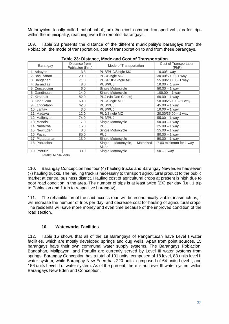
32
Motorcycles, locally called ‘habal-habal’, are the most common transport vehicles for trips within the municipality, reaching even the remotest barangays. 109. Table 23 presents the distance of the different municipality’s barangays from the Poblacion, the mode of transportation, cost of transportation to and from these barangays.
Table 23: Distance, Mode and Cost of Transportation
Barangay Distance from
Poblacion (Km.) Mode of Transportation
Cost of Transportation (PhP)
1. Adtuyon 3.5 PUB/PUJ/Single MC 10.00/1 way
2. Bacusanon 20.0 PUJ/Single MC 30.00/50.00- 1 way
3. Bangahan 71.0 PUJ/PUB/Single MC 55.00/200.00- 1 way
4. Barandias 8.0 PUB/PUJ 10.00 - 1 way
5. Concepcion 6.0 Single Motorcycle 50.00 – 1 way
6. Gandingan 14.0 Single Motorcycle 100.00 – 1 way
7. Kimanait 82.0 PUJ (via Don Carlos) 60.00 – 1 way
8. Kipaducan 69.0 PUJ/Single MC 50.00/250.00 – 1 way
9. Langcataon 62.0 PUB/PUJ 45.00 – 1 way
10. Lantay 3.0 PUB/PUJ 10.00 – 1 way
11. Madaya 12.0 PUJ/Single MC 20.00/35.00 – 1 way
12. Malipayon 74.0 PUB/PUJ 55.00 – 1 way
13. Mendis 7.0 Single Motorcycle 50.00 – 1 way
14. Nabaliwa 16.0 PUJ 25.00 – 1 way
15. New Eden 8.0 Single Motorcycle 55.00 – 1 way
16. Payad 85.0 PUJ 80.00 – 1 way
17. Pigtauranan 13.0 Single Motorcycle 50.00 – 1 way
18. Poblacion - Single Motorcycle, Motorized Sikad
7.00 minimum for 1 way
19. Portulin 30.0 Single Motorcycle 50 – 1 way Source: MPDO 2015
110. Barangay Concepcion has four (4) hauling trucks and Barangay New Eden has seven (7) hauling trucks. The hauling truck is necessary to transport agricultural product to the public market at central business district. Hauling cost of agricultural crops at present is high due to poor road condition in the area. The number of trips is at least twice (2X) per day (i.e., 1 trip to Poblacion and 1 trip to respective barangay). 111. The rehabilitation of the said access road will be economically viable, inasmuch as, it will increase the number of trips per day, and decrease cost for hauling of agricultural crops. The residents will save more money and even time because of the improved condition of the road section.
10. Waterworks Facilities
112. Table 16 shows that all of the 19 Barangays of Pangantucan have Level I water facilities, which are mostly developed springs and dug wells. Apart from point sources, 15 barangays have their own communal water supply systems. The Barangays Poblacion, Bangahan, Malipayon, and Portulin are currently served by Level III water systems from springs. Barangay Conception has a total of 101 units, composed of 18 level, 83 units level II water system; while Barangay New Eden has 220 units, composed of 64 units Level I, and 156 units Level II of water system. As of the present, there is no Level III water system within Barangays New Eden and Conception.

33
Table 24: Number of Households Served by Water Systems
Barangay Number of Households Served
Total Level I Level II Level III
1. Adtuyon 508 156 0 664
2. Bacusanon 1,096 53 0 1,149
3. Bangahan 396 0 140 536
4. Barandias 110 458 0 568
5. Concepcion 18 83 0 101
6. Gandingan 270 0 0 270
7. Kimanait 626 191 0 817
8. Kipaducan 264 165 0 429
9. Langcataon 190 90 0 280
10. Lantay 117 295 0 412
11. Madaya 225 0 0 225
12. Malipayon 325 0 308 633
13. Mendis 112 212 0 324
14. Nabaliwa 179 141 0 320
15. New Eden 64 156 0 220
16. Payad 119 82 0 201
17. Pigtauranan 183 164 0 347
18. Poblacion 336 251 1,284 1,871
19. Portulin 26 97 72 195
Total 5,164 2,594 1,804 9,562 Source: MPDO 2015
11. Power
113. The National Power Corporation (NAPOCOR) through the First Bukidnon Electric Cooperative or FIBECO, supplies all of the 19 barangays with electricity. In 2016, a total of 10,307 household in Pangantucan, or 90%, have access to electricity. Among all barangays, Barangay Concepcion has a total of 112 household or 62%, have access to electricity, and Barangay New Eden has a total Households of 152 or 57%, having access to electricity. Table 25 shows the number of household energized from 2012-2016.
Table 25: Number of Households Energized (Pangantucan) CY 2012-2016 2012 2013 2014 2015 2016
PANGANTUCAN 8,129 8,746 9,340 9,723 10,307
Concepcion 85 94 102 104 112
New Eden 134 139 143 148 152
Source: FIBECO 2016
12. Communication
114. The municipality of Pangantucan is one of the 22 bases of the province’s radio communication network, while postal services are provided by a government post office. A total of four (4) cell sites are installed within the municipality of Pangantucan owned and managed by SMART and GLOBE Telecommunication Companies.

34
13. Tourism
115. Local Ecotourism is yet to be developed in the municipality. Natural tourist attractions are existing, though they are not yet developed and be classified as viable economic enterprise. The potential tourist spots are the hot springs, lake, cold springs, picnic grounds, natural parks, water falls, and others. These spots are accessible through barangay roads and trails.
V. ANTICIPATED ENVIRONMENTAL IMPACTS AND MITIGATION MEASURES
116. The IEE, based on the screening of baseline environment and review of proposed civil works, has not identified any major environmental concerns due to proposed rehabilitation of New Eden, Concepcion access road and foot trail given that all the proposed civil works are only asset preservation of existing roadway and are located within existing right of way. There will only be localized short-term impacts during construction activities due to implementation of civil works that will be addressed in the detailed design and through implementation of the mitigation and monitoring measures specified in the environmental management plan. These construction related impacts can be mitigated by 1) the contractors’ work practices, especially those related to the systematized demolition procedure consistent with approved standard safety requirements; 2) cooperation by the local authorities with the contractor in terms of use of public space and utilities; 3) project management’s strict enforcement of the correct construction practices and standards; 4) the incorporation of the mitigation measures identified in the IEE into the bid documents and specifications; and 5) close monitoring of the contractor’s implementation of the required mitigation measures. 117. The potential environmental impacts resulting from implementation of civil works are expected to be minor and likely short-term since the improvement works will not involve widening and alignment adjustments (Table 26). Detailed environmental mitigation measures have been prepared for all the identified impacts and presented in the environmental management plan under Chapter VIII.
Table 26: Assessment of Potential Environmental Impacts
Potential Environmental Impacts or Values the Subproject construction would likely create:
Excavati
on
/
Str
uctu
ral
Excavati
on
Em
ba
nkm
en
t
Su
b-g
rad
e
Pre
pa
rati
on
Sto
ne
Ma
so
nry
Su
b-b
ase C
ou
rse/
Ag
gre
gate
Base
Co
urs
e/ S
urf
ace
Co
urs
e
Pip
e C
ulv
ert
Po
rtla
nd
Cem
en
t
Co
nc
rete
Pavem
en
t
Land surface disturbance – surface scrapping, top soil erosion, and vegetative clearing
moderate moderate moderate minor minor minor minor
Affects temporal water regime: decrease water quantity and quality and flow regularity or seasonality due to altered drainage patterns, water way configuration, sedimentation, turbidity, as well as river flow diversion
minor minor minor minor minor minor minor
Altered or impaired hydrology of the immediate area: increase peak and flood flows and irregular streamflow
minor minor minor minor minor minor minor
Decrease in downstream natural resources’ economic and social values/uses
minor minor minor minor minor minor minor
Decrease site’s attraction in terms of losing some geological or geomorphological values, particularly those of known local,
minor minor minor minor minor minor minor

35
Potential Environmental Impacts or Values the Subproject construction would likely create:
Excavati
on
/
Str
uctu
ral
Excavati
on
Em
ba
nkm
en
t
Su
b-g
rad
e
Pre
pa
rati
on
Sto
ne
Ma
so
nry
Su
b-b
ase C
ou
rse/
Ag
gre
gate
Base
Co
urs
e/ S
urf
ace
Co
urs
e
Pip
e C
ulv
ert
Po
rtla
nd
Cem
en
t
Co
nc
rete
Pavem
en
t
national or international nature conservation importance
Vegetation loss affecting rare species habitats, particularly of known local, national or international nature conservation importance
none none none none none none none
Adverse impact on local and transient fauna species (those species whose range may include the project site), particularly those of known local, national or international nature conservation importance.
none none none none none none none
Bio-invasion of new strain of pests, weeds or rare diseases
none none none none none none none
Frequent incurrence and increased intensity of grassfire
none none none none none none none
Contamination of the immediate and/or broader environment cause by the storage or use of chemicals needed for the construction works
minor minor minor none minor none minor
Air particulate emissions which may cause atmospheric / environmental pollution impacting on human health and livelihood at local or larger scale during construction phase
minor minor minor minor minor minor minor
Excessive solid waste accumulation during infrastructure construction
minor minor minor minor minor minor minor
Increase in noise and/or vibration during construction
minor minor minor minor minor minor minor
Unnatural lighting effects that may impact upon flora and fauna, or deplete the sense of naturalness of the area
none none none none none none none
Natural landscape fragmentation and discontinuity
none none none none none none none
Adverse impact on land use and the amenity values of adjacent or downstream areas (including the integrity of agricultural land, or other industry that the local community may depend on)
minor minor minor minor minor minor minor
Adverse impact on existing or potential recreational value and quality of known traditional experience associated to site natural setting
minor minor minor minor minor minor minor
Adverse impact or alter on-sites’ visual value and its surrounding area -from different vantage points
minor minor minor minor minor minor minor
Rating: None= no adverse impact; Minor= slight negative impact and momentary; Moderate=slight negative impact for a year but not damaging enough to cause ecological, health and economic disturbance.
118. During operation, the project is expected to benefit the environment and socio- economic conditions of the subproject areas through increased delivery of agricultural products, increased tourism, improved access and economic development, reduced dust due to asset preservation, improved road safety due to installation of safety signs, and others. 119. Environmental impacts and proposed mitigation measures during subproject pre-construction, construction and operation phases are described under Chapter VIII. Detailed environmental mitigation measures have been prepared for all the identified impacts and presented in the environmental management plan.

36
A. Pre-Construction
1. Confirmation of no required resettlement, relocations, and compensation 120. This will be undertaken prior to the commencement of any civil works. The proponent shall conduct consultation meetings with directly affected barangays and concerned POs’, and information awareness campaign regarding subproject location.
2. Identification and prioritization of road section where re-gravelling will be done
121. Identification and prioritization of road sections will be give information and participation of the community, particularly women and marginalized sectors. A subproject site validation will be facilitated to ensure that the INREMP validation process on subproject implementation is being complied with and hold consultative meetings with balanced representation of men and women and affected persons on the subproject components and management plan.
3. Preparation of detailed engineering designs and programs of work 122. The detailed engineering designs and programs of work for the subproject will be prepared by the LGU for the completion of the proposed upgraded access road. The detailed designs shall include the identification of spill management prevention and emergency response plans for all construction sites, locate aggregate borrow pits and rock supply areas away from human settlements with fencing and access barriers, and specific plan to notify and provide them schedule to minimize disruption to normal commercial and residential activities. 123. The LGU with assistance from the Project Management Implementation Consultants (PMIC) will ensure that relevant provisions of the EMP in terms of implementation of environmental mitigation measures, monitoring activities, supervision and reporting are included for civil works and construction supervision.
4. Recruitment of workers 124. The potential impact of the subproject will be hiring of skilled local workers and other unskilled jobs. A robust “local first” hiring policy will be designed and be implemented in coordination with local officials and community leaders especially at the barangay and municipal levels. The Contractor will be required to follow the “local first” hiring policy. B. Construction
1. Construction materials acquisition, transport access, and storage system
125. The contractors will source construction materials under their own arrangements. Uncontrolled sourcing of such materials could lead to environmental impacts such as the loss of topsoil or the disfigurements of the landscape from borrow pits. Earthen embankments and material stockpiles will be susceptible to erosion, particularly during the rains and re-suspension of dust during the dry seasons. 126. Local roads will be damaged during transportation of borrow materials and by the construction equipment. In order to reduce impact on all borrow sites, contractors will water the local roads close to the settlements used by the borrow trucks. As much as possible,

37
contractors will not make use of productive agricultural land. In case this is unavoidable, the contractor will obtain consent from the land owner and will restore the site to its original condition after completion of civil works.
2. Clearing and removal of obstructions
127. The contractors will initiate clearing and removal of obstructions on the existing road that would result to damaged landscape. It must be noted that there are no affected trees on the proposed access road rehabilitation project. However, other vegetation in the site are common and will recover after the construction. The contractors will not use or permit the use of wood as a fuel for the execution of any part of the works. The contractor will be required to minimize damage and cutting of surrounding vegetation during slope formation, and prevent erosion and protect the cut slope with temporary or permanent drainage as soon as practicable after cutting. If new erosion occurs accidentally, back fill immediately to restore original contours.
1. Soil erosion
128. Soil erosion and unstable side slopes susceptible to landslides are noticed along subproject road. The impact of soil erosion and unstable side slope are increased run off and sedimentation causing a greater flood hazard to the downstream, loss of topsoil affects the growth of vegetation that causes ecological imbalances, and development of unsightly cuts and fills that have been riddled by uncontrolled erosion and gullying. Construction activities should be taken up only during dry season. 129. During operation, silt load in the river is expected to be minor due to slope protection structures installed. The contractor will also be required to make additional measures to minimize erosion and landslides during construction phase such as 1) minimize damage and cutting of surrounding vegetation during slope formation, 2) prevent erosion and protect the cut slope with temporary drainage as soon as practicable after cutting, and 3) If new erosion occurs accidentally, back fill immediately to restore original contours.
2. Ground surface leveling and gravelling of existing road
130. During ground surface leveling and gravelling of existing road, the potential impacts would be minor and short-termed to the terrestrial resources as well as to the quality of surface water in the river. The contractor will be required to do the following: 1) the construction site should be located away from forested or plantation areas, 2) all construction fluids such as oils, and fuels should be stored and handled away from forested and plantation areas, 3) no waste of any kind is to be discarded on land or in forests/plantations, 4) erosion channels must be built around aggregate stockpile areas to contain rain-induced erosion, 5) earthworks should be conducted during dry periods, 6) no waste of any kind is to be thrown in surface waters, 7) no washing or repair of machinery near surface waters, 8) pit latrines to be located away from surface waters, 9) no unnecessary earthworks in or adjacent to water courses, 10) no aggregate mining from rivers or lakes, and 11) minimize the use of heavy equipment at steep slopes.
3. Civil works
131.. Since the subproject will mainly involve concrete pavement (with no road widening and realignments), main impacts on land during construction are from air pollution, land and water contamination, and traffic and access problems. The contractor will apply stated mitigating measures during concrete pavement and stone masonry activities such as 1) piling of aggregates at sites should be used/or removed promptly, or covered and placed in non-traffic

38
areas, and 2) all spills should be cleaned immediately and handled as per hazardous waste management plan, and according to government regulations.
4. Implementation of noise and dust control measure
132.. During construction, air quality will certainly decrease by exhaust emissions from construction equipment, dust generated from haul roads, unpaved roads, exposed soils and material stock piles. 133. To mitigate the declining air quality problem during construction, the following will be implemented: 1) regularly apply wetting agents to exposed soil and construction roads, 2) cover or keep moist all stockpiles of construction aggregates, and all truckloads of aggregates, 3) minimize the time for excavations and exposed soil are left open or exposed, 4) backfill immediately after work is completed, 5) restrict working time between 7:00 am and 5:00 pm, 6) maintain equipment in proper working condition, 7) replace unnecessarily noisy vehicles and machinery, 8) vehicles and machinery to be turned off when not in use, and 9) construct temporary noise barriers around excessively noisy activity areas if possible.
5. Dust and noise from borrow pits
134. Noise and dust may be generated from borrow pits. The contractor will ensure the following mitigating measures: 1) provision of noise control measures to comply with national standards, watering of the earth roads close to the settlements, use covered truck, 2) secure appropriate environmental permits, 3) the borrow and material dumping sites must be access controlled to keep away unauthorized entry of people, grazing cattle and any other stray animals, and 4) protective gear like ear plugs will be provided to operating personnel if they are exposed to noise levels beyond threshold limits.
6. Implementation of spoil management and control measure
135. The contractor will ensure that there will be no contamination of land and surface waters from excavated spoils, and construction wastes. The uncontaminated spoils will be disposed of in municipal or provincial designated sites, which must never be in or adjacent surface water. On the other hand, suspicious contaminated soil will be tested, and disposed of in designated sites identified as per government regulations.
7. Solid and liquid construction waste management system
136. Solid and liquid construction wastes management system will be facilitated to avoid contamination of land and surface water from the construction wastes. The management of general solid and liquid wastes of construction will follow government regulations to include covering, collecting, handling, transporting, recycling, and disposing waste created from construction activities and the work force. A schedule of solid and liquid waste pickup and disposal will be established and followed to ensure construction sites are as clean as possible. All solid wastes will be separated and recyclables be donated to the barangay. There will be no site-specific landfills established by the contractors. All solid waste will be collected and removed from the work camps and disposed in local waste disposal sites.
8. Water quality
137. The subproject has potential impacts on water quality due to washing of equipment (i.e. vehicles and concrete mixers), and leakage and spills from discharge from worker camps to the water resources. To mitigate, there should be a 1) set up proper and adequate sanitary facilities, 2) ensure strict observance of proper waste handling and disposal and proper sanitation including by the contractors and its workers, 3) provide wastewater treatment facility

39
(e.g., septic tank), and 4) trucks and other vehicle maintenance should be strictly controlled to prevent the discharge of waste into the river system. Wastewater from the construction works containing high concentration of suspended solids should be treated through sedimentation tanks. 5) The discharge of cement-laden water and slurry during concrete mixing may contaminate water resources and damage productive land in the surrounding areas. To mitigate possible effects of cement-laden water and slurry, the Contractor shall i) collect and retain all the concrete washout water and solids in leak proof containers, so that this does not reach the soil surface and then migrate to surface waters or into the ground water, ii) recycle the collected concrete washout water and solids, and/or iii) use of a washout pit made with a plastic lining that can be dug into the ground or built above grade.
9. Construction drainage system
138. The contractor shall construct drainage systems to facilitate drainage and rain water natural channels. The contractor will also provide adequate short-term drainage away from construction sites to prevent ponding and flooding.
10. Workers health, safety and hygiene
139. Construction sites are likely to have public health impacts. Contractors will ensure that no untreated wastewater is discharged in the river and that no site-specific landfills will be established at the construction camps. There will be a potential for diseases to be transmitted, exacerbated by inadequate health and safety practices. The contractor will therefore be required to recruit or designate a health and safety officer to address such concerns in the work sites and liaise/work with the nearby communities. 140. Mitigation measures include: 1) proper fencing, protective barriers, and buffer zones should be provided around all construction sites, 2) sufficient signage and information disclosure, and supervisors and night guards should be placed, 3) worker and public safety guidelines should be followed, 4) provide adequate sanitation and waste disposal at construction sites, 5) the contractor will not hire children and pregnant women, 6) standing water suitable for disease vector breeding should be filled in, 7) worker education and awareness seminars for construction hazards should be given at the beginning of the construction phase. A construction site safety program should be developed and distributed to workers, 8) appropriate safety clothing, footwear, gloves, hard hats, eye protection and other PPE should be mandatory for all construction workers, 9) adequate medical services must be on site or nearby all construction site, 10) drinking water must be provided at all construction sites, 11) sufficient lighting be used during necessary night work, and 12) all construction sites should be examined daily to ensure unsafe conditions are removed.
11. Traffic safety and management
141. Throughout the construction period, the contractor should ensure that affected people are provided adequate and safe access to properties (structures, land, etc.). During construction, the contractor is responsible for ensuring that all construction vehicles observe speed limits on the construction sites and to provide adequate signage, barriers, and flag persons for traffic control. Sign postings such as ‘men working’, ‘Keep left/right’, ‘construction ahead’, and ‘speed limit’, should be used for traffic management and road safety. As much as possible, road works will be confined to one half of the road width at each section to provide access to pedestrian and vehicles during construction works.

40
12. Ecological environment (Flora and Fauna)
142. Rehabilitation work will directly cause minor degradation of the local ecology through the clearance of small areas of vegetation (mainly grasses) at major work sites. A short-term impact on ecology along the rehabilitated road is likely to occur in worksites during the construction period due to minor vegetation clearance (mainly grasses, not trees). Vegetative cover stripped from the locations described above will be kept for slope protection. 143. Meanwhile, the potential impacts from construction worker camps are poaching of edible animals and birds of the locality in spite of prohibitions. The contractors’ will be responsible for providing adequate knowledge to the workers regarding the protection of fauna. In short, all workers will be prohibited from hunting wild animals.
13. Damaged to properties
144. Another potential impact during construction is damaged to properties (structures, irrigation, farmland) and access roads due to civil works, transport of materials and other project-related activities. To address this impact, the contractor will immediately repair and/or compensate for any damage that it causes to properties (houses, farmlands, aquaculture ponds, irrigation canals, and others), community facilities such as water supply, power supply, communication facilities and the like. Access roads used for transport of construction materials and other construction-related activities will be maintained by the Contractor in at least in their pre-project condition for the duration of construction.
14. Concrete washout
145. The discharge of cement-laden water and slurry during concrete mixing may contaminate water resources and damage productive land in the surrounding areas. To mitigate possible effects of cement-laden water and slurry, the Contractor shall 1) collect and retain all the concrete washout water and solids in leak proof containers, so that this does not reach the soil surface and then migrate to surface waters or into the ground water, 2) recycle the collected concrete washout water and solids, and/or 3) use of a washout pit made with a plastic lining that can be dug into the ground or built above grade.
15. Use of Hazardous Substances
146. Storage and use of fuel, lubricant and other toxic and hazardous chemicals will have potential impacts on soil surface and groundwater contamination. To address this impact, vehicle maintenance and refueling will be confined to areas in construction sites designed (with concrete flooring, drainage leading to oil and water separator, etc.) to contain spilled lubricants and fuels. Spill waste will be disposed to sites approved by the concerned government agency and following national regulations. Adequate precaution will be taken to prevent oil/lubricant/ hazardous substances contamination of channel beds. Spillage if any will be immediately cleared with utmost caution to leave no traces. All areas intended for storage of hazardous materials will be quarantined and provided with adequate facilities to combat emergency situations such as fire, spills, etc. in compliance with all the applicable statutory stipulation. The personnel in-charge of these sites will be properly trained and these areas will be access controlled and entry will be allowed only under authorization. Hazardous wastes will be collected, stored, transported and disposed consistent with national regulations to ensure that these will not cause pollution of surrounding areas.

41
16. Public safety
147. `Some of the mitigation measures that should be implemented are as follows: To mitigate this impact, the following should be addressed by the Contractor: 1) installation of sturdy fencing around excavation areas and construction sites, 2) provision of proper signage and lighting at night at the periphery of the construction site to warn and direct traffic and pedestrians, 3) deployment of security personnel in hazardous areas to restrict public access, 4) imposition of speed limits for construction vehicles along residential areas and where there are other sensitive receptors, and 5) orientation of drivers on safe driving practices to minimize accidents and to prevent spill of hazardous substances and other construction materials during transport. C. Operation and Maintenance (O&M) Phase
1. Operation of upgraded access road
148. The rehabilitation of New Eden access road and foot trail will have potentials impacts both positive and negative to the area. The negative impacts will directly involve the increased risk of accident or injury, air pollution and noise, and unplanned urbanization. However, the positive impacts will mainly focus on increased delivery of agricultural products, provide access to natural resources management project sites, and open for tourism businesses. To mitigate these impacts, the LGU of Pangantucan and other concerned agencies shall initiate and implement the following: 1) set speed limit when passing through populated area, 2) provide appropriate warning signs and lighting, 3) regular removal of debris, logs and other materials along drainage canals to avoid clogging, 4) regular vegetation control along run-off area to ensure free flow, 5) ensure that existing environmental management policies are effectively implemented and proper coordination involves different agencies, 6) adherence to land use and zoning regulations, and 7) promote tourism in the area through advertisement from the local and nationwide venue.
VI. INFORMATION DISCLOSURE, CONSULTATION, AND PARTICIPATION
A. Stakeholder Consultations
149. With the involvement of the LGU in the subproject activities of INREMP particularly in the implementation of RI support facilities under Component 2, they dedicated time and effort in participating with orientation and consultation activities of the subproject. The implementation of the subproject also implicated some expenses to the LGU during held meetings and field activities performed in the municipality and for transport costs in attending training and workshops conducted by the project even outside the municipality of Pangantucan. 150. Each influence barangay conducted a barangay consultation where they discussed priority projects of their barangay. Consistent with the site validation result conducted last 14 November, 2016, the sub-project was assessed to unlikely cause significant adverse impact on the environment; in fact, the subproject is identified by the community members to improve the status of the environment as it will serve as a corridor in mitigating forest fires in the area. 151. After several consultations of the community and barangay offices, the two (2) influenced barangays endorsed the proposed road rehabilitation of New Eden - Concepcion

42
access road and foot trail for inclusion to INREMP rural infrastructure component (Appendices 2 and 3). However, discussions on subprojects revealed lack of funds. Since barangay allocation was not enough to support the sub-project, the barangay officials agreed to submit an endorsement letter to Sangguniang Bayan requesting for inclusion of their barangay project in the priority projects of the municipality. 152. In the proposed subproject involving the rehabilitation of New-Eden – Concepcion access road and foot trails, there are several activities conducted to ensure that the project will be beneficial to the partners and other stakeholders. There was a public consultation conducted last July 27, 2017 at Brgy. New Eden, Day Care Center Pangantucan, Bukidnon. The proponent with technical assistance of consultant has made presentation of the Subproject describing the objective of the consultations, project description, proposed civil works, and anticipated environmental impacts and their mitigation measures. The consultations went very well and effective and the discussions were documented. The results of the consultation were positive, with local people considering that the road will bring significant economic benefits to the barangays and increase trade flows. Concerns on the subproject mainly revolved on its construction phase which can be mitigated. No long term negative environmental impact assessed by the participants. Majority of the respondents cited ease of transport as one of the direct benefits of the road; majority of them as well are not anticipating any negative impact of the subproject to the environment though one of the respondents mentioned that the road might be a corridor for illegal loggers to access the forest land so he suggested an intensified barangay patrolling during the operation phase of the access road. 153. At the end of the meetings, the participants were given questionnaires to express their views and concerns of the subproject. Details of the consultations and issues raised during these consultations are given in Table 27 and Appendix 4.
Table 27: Summary of Stakeholder Consultation of the Road Access and Foot Trail Rehabilitation in Pangantucan
Date : July 27, 2017
Venue: Brgy. New Eden, Day Care Center Pangantucan, Bukidnon
Number of Participants: 50
Representative of Participants: IP members, New Eden Residents, PO, MPDC
Questions Responses
Benefits from the road rehabilitation expressed by on-site and off-site stakeholders
The following are the responses of the participants when asked what benefits they’re expecting to gain from the subproject:
In case of forest fires, fire responders could easily reach the area and put off the fire
Ease of product transport from farm to market, the subproject road will serve as a shortcut thus minimizing delivery travel time of goods
Save in Transportation Cost
Monitoring of forest resources would be easier. BLGU committed to be stricter with environment and natural resources protection initiatives.
Pre- construction phase issues
Beneficiaries Response Project Management Team Response
No issues were identified in this phase (see B. Findings: Pre-construction phase)
No issues were identified in this phase
Construction phase issues
The contractor may accidentally spill diesel in nearby lots while refueling their heavy vehicles.
The contractor embanking the excavated soil anywhere by the road.
PO Suggestion/s:
BLGU and MLGU to request to the contractor to properly dispose waste, preferably outside the barangay. In addition, BLGU and POs to put up signage for proper waste disposal
Request the contractor, whoever it may be, to excavate slowly and cautiously and embank the soil immediately to road sections that need to be filled.

43
Date : July 27, 2017
Venue: Brgy. New Eden, Day Care Center Pangantucan, Bukidnon
Number of Participants: 50
Representative of Participants: IP members, New Eden Residents, PO, MPDC
Questions Responses
Concrete/ cement improper handling
Contractor washing their equipment on the nearby water surface.
POs should take the initiative to put up canals alongside the road so that runoff from the road construction will not directly go to the rice fields
PO and BLGU would ensure that the contractor will not mix cement near the ricefield and/or the water surface nearby. Contractor should be advised to have their own mixing board. Contractor should also be advised to concrete one line at a time so as not to hinder transport of goods and services
Facilitator’s Suggestion/s:
Engr. Tingson also suggested that PO members should remain watchful during the course of subproject implementation.
Reinforce signage on proper cleaning of materials, equipment
Operation and maintenance phase issues
Improper waste disposal on the road as there will be increase of people passing by
Possible increase of vehicles utilizing the road, that may result to incidence because vehicle riders may increase their speed since the road would already be in a good condition.
Improved condition of road provides opportunity for illegal loggers to access forestry resources
PO member suggested that maintenance activities should be regularly conducted. Canals should also be cleaned regularly
Another PO member suggested that road safety signs such as speed limits should be put up along the road.
A barangay kagawad said that BLGU should allot budget for maintenance of road.
Plant trees along the road to provide shade
Barangay to monitor activities within its jurisdiction which is easier because of improved road facility.
Facilitator’s Suggestion/s:
Engr. Tingson suggested that each PO should be responsible of cleaning the canals.
Suggested impact mitigation measures
Aside from the anticipated issues and its corresponding mitigations/ responses mentioned on the previous table, the TA-PMIC also identified potential issues and mitigation measures that the subproject might face. These issues and measures are all captured on the Environmental Impact Mitigation Plan.
B. Information Disclosure
154. After study completion, the IEE documenting the mitigation measures and consultation process will be submitted to ADB for posting on their website, DENR-FMB, the Municipality of Pangantucan, Bukidnon and the two affected Barangay offices, the Provincial Environmental and Natural Resource Officer, and DENR regional office, which will make them available to the public. More informal and vigorous level of disclosure and consultation will be done during implementation through:

44
• The preparation and dissemination of a brochure in local languages, explaining the affected peoples’ entitlements and the procedures for obtaining compensation for temporary disturbances, crops, and land for construction camps and recording grievances; and
• Setting up a formal grievance redress committee with a representation from the
affected people. Field consultant in association with the Contractor will be responsible for managing the effective grievance redress program.
VII. GRIEVANCE REDRESS MECHANISM
155. The Local Government Unit of Pangantucan has properly conducted the consultations with the different stakeholders of the subproject site. However, it still has to make room for possible issues, concerns, or grievances and disputes arising from the communities in relation to the project implementation. Thus, it sets up a Grievance Redress Mechanism to provide a venue for resolving grievances and disputes even at the lowest level. This will be done to resolve disputes as early and as quickly as possible before it escalates to an unmanageable level.
156. Since, the community consultations were conducted smoothly and no adverse or violent reactions have been noted, there are only minor grievances that are anticipated which may arise. These are listed below:
1) Road accessibility related grievances – This may include complaints from
communities using the roads under repair or construction due to temporary obstruction, which may cause delay in travel time and other inconveniences of the travelling public.
2) Construction related grievances – Community members may demand to be hired
as part of the labor force in the project construction/implementation. This may also include complaints of community members regarding noise, drainage, and etc.
3) Indigenous Peoples related grievances – may come from IPs residing within the
influence areas concerned with potential effects to ecological and social resources of their area/abode.
157. If case grievances and disputes do arise, there are existing groups in the area which can be tapped to form part of the GRM. In fact, different active groups exist in the area such as the Barangay Development Council (BDC) with its Lupon which is mainly in-charge of settling disputes related to barangay administration, and the IP Chieftain and IP Mandatory Representative, which also takes care of resolving disputes relating to the indigenous people residing in the barangay. 158. A subproject-specific grievance redress mechanism will be established at the PPCO to receive, evaluate and facilitate the complaints/grievances of affected persons on the sub-project’s environmental performance. This mechanism will be disclosed to the host communities before start of civil works. 159. The grievance redress committee (GRC) will be chaired by the Provincial Project Management Offices (PPCO) head. Members will include the following: (i) designated GRM officer of PPCO, (ii) contractor’s highest official at the site such as the Construction Manager or the Construction Superintendent; and (iii) barangay chairperson. For the quick filing of complaints, the GRC will use the attached grievance intake form (Appendix 5). The PPCO's

45
GRM officer will be responsible for registration of grievances and communication with the aggrieved party. 160. The steps to be followed in filing complaints and the procedures for redress are the following:
(i) complainant will provide the background and file the complaint verbally or in writing to the PPCO, and the PPCO's GRM officer will assist the complainant in filling-up the grievance intake form;
(ii) within 2 working days, the GRM Officer, contractor’s representative, and complainant will discuss if the complaint can be resolved without calling for a GRC meeting;
(iii) within 3 days of lodging the complaint, the PPCO's GRM officer will provide the complainant a written feedback on the process, steps and timeframe for resolving the complaint.
(iv) if the complaint cannot be resolved, a GRC meeting with the complainant will be called within 5 working days;
(v) the GRC will have 15 working days to resolve the complaint; (vi) the complainant will receive feedback from the PPCO's GRM officer within 5
working days after the various steps of the GRM are completed; and (vii) if unsatisfied with the decision, the existence of the GRC will not impede the
complainant's access to the Government's judicial, administrative remedies or through concerned government agencies (e.g., Community Environment and Natural Resources Office and Provincial Environment and Natural Resources Office of DENR, Regional offices of the Environmental Management Bureau, etc.)
161. The GRC will receive, follow-up and prepare monthly reports regarding all complaints, disputes or questions received about the Project and corresponding actions taken to resolve the issues. These reports will be included in the semi-annual environmental monitoring reports to be submitted to ADB. Grievance Among IPs
162. Giving primacy to the traditional conflict resolution system, grievances will be handled following the procedure outlined below. In resolving disputes among the indigenous peoples, the determination or decision is usually reached through dialogue and consensus. There may be several conflict resolution sessions according to the specific tribe’s customary laws before the dispute may be resolve. Thus, there is no clear definite timeline on when the conflict or dispute should be settled at the level of the clan and the Council of Elders.
a. Dispute/grievance will be resolved first among the members of the clan; b. If the said grievance/dispute is not resolved at the clan level, this will be brought to
the level of the Council of Elders (COE); and c. If still unresolved at the COE level, the said dispute/grievance will be submitted to
the NCIP Regional Hearing Officer (RHO), for resolution, where the decision will be final and executory. The dispute/ grievance will be heard and adjudicated in accordance with the Rules on Pleadings, Practice and Procedures before the NCIP.

46
VIII. ENVIRONMENTAL MANAGEMENT PLAN
A. Implementation Arrangements
163. Institutions responsible for executing and monitoring the implementation of the EMP are presented in Table 28.
Table 28: Responsibilities for EMP Implementation
Agency Responsibilities
LGU of Pangantucan, Bukidnon • Executing agency with overall responsibility for project construction and operation
• Ensure that sufficient funds are available to properly implement the EMP
• Ensure that Project implementation complies with Government environmental policies and regulations
• Ensure that the Project, regardless of financing source, complies with the provisions of the EMP and ADB Safeguard Policy Statement 2009
• Obtain necessary environmental approval(s) from the Environmental Management Bureau and/or other concerned government agencies prior to commencement of civil works
• Ensure that tender and contract documents for design, supervision and civil works include the relevant EMP requirements
• Establish an environmental grievance redress mechanism, as described in the IEE, to receive and facilitate resolution of affected peoples' concerns
• Submit semi-annual monitoring reports on EMP implementation to ADB.
Existing ADB Project Management Office
• Project management office with direct responsibility for the implementation of civil works, engineering designs and project coordination.
• Ensure that EMP design measures are incorporated in the detailed design
• Ensure that EMP provisions are strictly implemented and monitored during various project phases (design/pre-construction, construction and operation) to mitigate environmental impacts to acceptable levels
• Include relevant provisions of the EMP in the bid and contract documents for design, civil works and supervision.
PPMO, and Watershed Management And Project Coordination Offices (WMPCO)
• Closely monitor contractor’s environmental performance and over-all implementation of the EMP
• Prepare semi-annual environmental monitoring reports on status of EMP implementation for submission to ADB
• Based on the results of EMP monitoring, identify environmental corrective actions and prepare a corrective action plan, as necessary, for submission to ADB
• Responsible for coordinating with EMB, Local Government Units (LGU), and other concerned agencies related to environmental aspects for maintaining project`s compliance with environmental permits.
TA – PMIC, and National Project Coordinating Office
• . Engage environment specialists who will undertake supervision and monitoring of EMP implementation and contractor’s environmental performance

47
• As part of day-to-day project supervision, closely supervise and monitor the contractor’s implementation of mitigation measures specified in the EMP
• Assist PMU and WMPCO in preparing semi-annual environmental monitoring reports on status of EMP implementation. Such report will include results of ambient environmental monitoring to be conducted by the contractors.
Contractors • Recruit qualified environmental and safety officer to ensure compliance with environmental statutory requirements, contractual obligations and EMP provisions
• Provide sufficient funding and human resources for proper and timely implementation of required mitigation and monitoring measures in the EMP
• Implement additional environmental mitigation measures, as necessary, to avoid, minimize and/or compensate for adverse impacts due to construction works and related activities performed by the contractor.
EMB - DENR • Review and approve environmental assessment reports required by the Government
• Undertake monitoring of the project’s environmental performance based on their mandate
ADB • Conduct periodic site visits to assess status of EMP implementation and over-all environmental performance of the Project
• Review environmental monitoring reports submitted by the executing agency to ensure that adverse impacts and risks are properly addressed
• Publicly disclose through posting on ADB’s website environmental monitoring reports, corrective action plans, new or updated IEE (if any) prepared by the executing agency during project implementation
B. Environmental Mitigation
164. Table 29 presents environmental mitigation measures to address anticipated adverse impacts of the Sub-project. The EMP also shows responsibilities for implementation of mitigation measures and corresponding supervision and monitoring.
Table 29: Environmental Impact Mitigation Plan
Project Component/Activity
Potential Environmental Impacts
Mitigation Measures Institutional Responsibilities
Cost Estimates
Implementation Monitor
Pre-Construction Phase
Confirmation of no required resettlement, relocations, and compensation
No negative environmental impacts
Conducted Consultation meetings with barangay officials and concerned POs’ officers and members
Conducted information awareness campaign regarding subproject location
LGU of Pangantucan
WMPCO PPMO
Identification and prioritization of road section where re-gravelling will be done
Lack of information and/or low participation of the community, particularly women and marginalized sectors
Subproject sites validation with following conditions:
ensure that the INREMP validation process on subproject implementation is being complied with
LGU of Pangantucan
WMPCO PPMO

48
Table 29: Environmental Impact Mitigation Plan
Project Component/Activity
Potential Environmental Impacts
Mitigation Measures Institutional Responsibilities
Cost Estimates
Implementation Monitor
hold consultative meetings with balanced representation of men and women and affected persons on the subproject components and management plan
Preparation of detailed engineering designs and programs of work for the subproject
Minimize negative environmental impacts
Work with LGU RI Engineer for the completion of the proposed upgraded access road detailed designs and to ensure the following measures are included:
identification of spill management prevention and emergency response plans for all construction sites;
locate aggregate borrow pits and rock supply areas away from human settlements with fencing and access barriers;
for local residents: include specific plan to notify and provide them schedule to minimize disruption to normal commercial and residential activities
LGU of Pangantucan
WMPCO PPMO
Recruitment of workers Gender discrimination and tendency to recruit outsiders
Hire local workers as much as possible, and give equal privilege for women to get involved in selected tasks appropriate for them
Contractor
LGU of Pangantu
can / WMPCO PPMO
Construction Phase
Construction materials acquisition, transport access, and storage system
Pollution, injury, interrupted usual road use, disrupted access, noise
Procure construction
materials from sources with
valid environmental
clearances, i.e. for sand,
gravel and timber from those
with valid DENR-MGB/EMB
permits.
All borrow pits and quarries
should be approved by
Municipal Engineering
Division.
Select pits and quarries in areas with low gradient and as close as possible to construction the sites.
Required aggregate volumes must be carefully calculated prior to extraction to prevent wastage.
Pits and quarries should not be located near surface waters, forested areas, critical habitat for wildlife, or cultural objects and landmarks.
If aggregate quarrying from fluvial environments is required small streams and rivers should be used, and dry alluvial plains preferred.
All topsoil and overburden removed should be stockpiled for later restoration.
All borrow pits and quarries should have a fence perimeter with signage to keep public away.
After use pits and quarries should be dewatered and
Contractor LGU of Pangantu
can / WMPCO PPMO
Part of the contractor’s contract

49
Table 29: Environmental Impact Mitigation Plan
Project Component/Activity
Potential Environmental Impacts
Mitigation Measures Institutional Responsibilities
Cost Estimates
Implementation Monitor
permanent fences installed with signage to keep public out, and restored as much as possible using original overburden and topsoil.
Unstable slope conditions in/adjacent to the quarry or pit caused by the extractions should be rectified with tree planting.
Define & schedule how materials are extracted from borrow pits and rock quarries, transported, and handled & stored at sites.
Define and schedule how fabricated materials such as steel, wood structures, and scaffolding will be transported and handled.
All aggregate loads on trucks should be covered.
Clearing and removal of obstructions
Damage landscape Restrict vegetation removal to within RoWs.
In case, no trees will be removed without prior approval of concerned government agency.
The contractor will not use or permit the use of wood as a fuel for the execution of any part of the works, including but not limited to the extent practicable shall ensure that fuels other than wood are used for cooking.
Within RoWs, minimize land cover removals, and install protective physical barriers around trees.
All RoWs to be re-vegetated and landscaped after construction completed.
Consult PENRO/CENRO to determine the most successful restoration strategy and techniques.
Contractor LGU of Pangantu
can / WMPCO PPMO
Part of the contractor’s contract
Soil erosion High suspended solid contents of river, sedimentation.
Berms, and plastic sheet fencing should be placed around all excavations and earthwork areas.
Earthworks should be conducted during dry periods.
Maintain a stockpile of topsoil for immediate site restoration following backfilling.
Protect exposed or cut slopes with planted vegetation and have a slope stabilization protocol ready.
Re-vegetate all soil exposure areas immediately after work is completed.
minimize damage and cutting of surrounding vegetation during slope formation,
prevent erosion and protect the cut slope with temporary drainage as soon as practicable after cutting, and
If new erosion occurs
Contractor LGU of Pangantu
can / WMPCO PPMO
Part of the contractor’s contract

50
Table 29: Environmental Impact Mitigation Plan
Project Component/Activity
Potential Environmental Impacts
Mitigation Measures Institutional Responsibilities
Cost Estimates
Implementation Monitor
accidentally, back fill immediately to restore original contours.
Ground surface leveling and gravelling of existing road
Degradation of terrestrial and aquatic resources, and decreased water quality
All construction sites should be located away from forested or plantation areas as much as possible.
All construction fluids such as oils, and fuels should be stored and handled away from forested and plantation areas.
No waste of any kind is to be discarded on land or in forests/plantations.
Erosion channels must be built around aggregate stockpile areas to contain rain-induced erosion.
Earthworks should be conducted during dry periods.
All construction fluids such as oils, and fuels should be stored and handled with extra care away from surface waters.
No waste of any kind is to be thrown in surface waters.
No washing or repair of machinery near surface waters.
Pit latrines to be located away from surface waters.
No unnecessary earthworks in or adjacent to water courses.
No aggregate mining from rivers or lakes.
Minimize the use of heavy equipment at steep slopes.
Contractor LGU of Pangantu
can / WMPCO PPMO
Part of the contractor’s contract
Civil works (Concrete Pavement)
Air pollution, land and water contamination, and traffic & access problems,
All construction sites should be located away from forested or plantation areas as much as possible.
All construction fluids such as oils, and fuels should be stored and handled away from forested and plantation areas.
No waste of any kind is to be discarded on land or in forests/plantations.
Protective berms, plastic sheet fencing, or silt curtains should be placed between all earthworks and nearby surface waters.
Erosion channels must be built around aggregate stockpile areas to contain rain-induced erosion.
Earthworks should be conducted during dry periods.
All construction fluids such as oils, and fuels should be stored and handled with extra care away from surface waters.
No waste of any kind is to be thrown in surface waters.
No washing or repair of machinery near surface waters.
Pit latrines to be located away from surface waters.
No unnecessary earthworks in
Contractor LGU of Pangantu
can / WMPCO PPMO
Part of the contractor’s contract

51
Table 29: Environmental Impact Mitigation Plan
Project Component/Activity
Potential Environmental Impacts
Mitigation Measures Institutional Responsibilities
Cost Estimates
Implementation Monitor
or adjacent to water courses.
No aggregate mining from rivers or lakes.
Implementation of noise and dust control measure
Noise, Dust, Air Pollution
Regularly apply wetting agents to exposed soil and construction roads.
Cover or keep moist all stockpiles of construction aggregates, and all truckloads of aggregates.
Minimize the time for excavations and exposed soil are left open or exposed. Backfill immediately after work is completed.
As much as possible, restrict working time between 07:00 and 17:00, in particular, activities such as pile driving, etc.
Maintain equipment in proper working condition
Replace unnecessarily noisy vehicles and machinery.
Vehicles and machinery to be turned off when not in use.
Construct temporary noise barriers.
Contractor LGU of Pangantu
can / WMPCO PPMO
Part of the contractor’s contract
Dust and noise from borrow pits
Noise, Dust provision of noise control measures to comply with national standards, watering of the earth roads close to the settlements, use covered truck,
secure appropriate environmental permits,
the borrow and material dumping sites must be access controlled to keep away unauthorized entry of people, grazing cattle and any other stray animals, and
protective gear like ear plugs will be provided to operating personnel if they are exposed to noise levels beyond threshold limits.
Contractor LGU of Pangantu
can / WMPCO PPMO
Part of the contractor’s contract
Implementation of spoil management and control measure
Contamination of land and surface waters from excavated spoil, and construction waste
Uncontaminated spoil to be disposed of in government –designated sites, which must never be in or adjacent surface waters. Designated sites must be clearly marked and identified.
Spoil must not be disposed of on sloped land, near cultural property or values, ecologically important areas, or on/near any other socially or ecologically sensitive feature.
Where possible spoil should be used at other construction sites, or disposed in spent quarries or borrow pits.
A record of type, estimated volume, and source of disposed spoil must be recorded.
Uncontaminated spoil to be disposed of in government –designated sites, which must never be in or adjacent surface
Contractor LGU of Pangantu
can / WMPCO PPMO
Part of the contractor’s contract
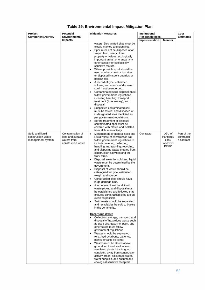
52
Table 29: Environmental Impact Mitigation Plan
Project Component/Activity
Potential Environmental Impacts
Mitigation Measures Institutional Responsibilities
Cost Estimates
Implementation Monitor
waters. Designated sites must be clearly marked and identified.
Spoil must not be disposed of on sloped land, near cultural property or values, ecologically important areas, or on/near any other socially or ecologically sensitive feature.
Where possible spoil should be used at other construction sites, or disposed in spent quarries or borrow pits.
A record of type, estimated volume, and source of disposed spoil must be recorded.
Contaminated spoil disposal must follow government regulations including handling, transport, treatment (if necessary), and disposal.
Suspected contaminated soil must be tested, and disposed of in designated sites identified as per government regulations.
Before treatment or disposal contaminated spoil must be covered with plastic and isolated from all human activity.
Solid and liquid construction waste management system
Contamination of land and surface waters from construction waste
Management of general solid and liquid waste of construction will follow government regulations to include covering, collecting, handling, transporting, recycling, and disposing waste created from construction activities and the work force.
Disposal areas for solid and liquid waste must be determined by the government.
Disposal of waste should be catalogued for type, estimated weigh, and source.
Construction sites should have large garbage bins.
A schedule of solid and liquid waste pickup and disposal must be established and followed that ensures construction sites are as clean as possible.
Solid waste should be separated and recyclables be sold to buyers in the community.
Hazardous Waste
Collection, storage, transport, and disposal of hazardous waste such as used oils, gasoline, paint, and other toxics must follow government regulations.
Wastes should be separated (e.g., hydrocarbons, batteries, paints, organic solvents)
Wastes must be stored above ground in closed, well labeled, ventilated plastic bins in good condition, away from construction activity areas, all surface water, water supplies, and cultural and ecological sensitive receptors.
Contractor LGU of Pangantu
can / WMPCO PPMO
Part of the contractor’s contract

53
Table 29: Environmental Impact Mitigation Plan
Project Component/Activity
Potential Environmental Impacts
Mitigation Measures Institutional Responsibilities
Cost Estimates
Implementation Monitor
All spills must be cleaned up completely with all contaminated soil removed and handled with by contaminated spoil sub-plan.
Construction drainage system
Loss of drainage and rain water natural channels
Provide adequate short-term drainage away from construction sites to prevent ponding and flooding.
Prevent borrow pits and quarries to be filled with water. Pump periodically to infiltration areas or nearby water courses.
Install temporary storm drains or ditches for construction sites
Ensure connections among surface waters (ponds, streams) are maintained or enhanced to sustain existing storm water storage capacity.
Protect surface waters from silt and eroded soil.
Contractor LGU of Pangantu
can / WMPCO PPMO
Part of the contractor’s contract
Water quality Water and soil Set up proper and adequate sanitary facilities,
Ensure strict observance of proper waste handling and disposal and proper sanitation including by the contractors and its workers,
Provide wastewater treatment facility (e.g., septic tank), and
Trucks and other vehicle maintenance should be strictly controlled to prevent the discharge of waste into the river system. Wastewater from the construction works containing high concentration of suspended solids should be treated through sedimentation tanks.
The discharge of cement-laden water and slurry during concrete mixing may contaminate water resources and damage productive land in the surrounding areas. To mitigate possible effects of cement-laden water and slurry, the Contractor shall 1) collect and retain all the concrete washout water and solids in leak proof containers, so that this does not reach the soil surface and then migrate to surface waters or into the ground water, 2) recycle the collected concrete washout water and solids, and/or 3) use of a washout pit made with a plastic lining that can be dug into the ground or built above grade.
Contractor SPMU PPMO
Part of the Contractor’s contract
Implement construction drainage system
Loss of drainage and rain water natural channels
Provide adequate short-term drainage away from construction sites to prevent ponding and flooding.
Prevent borrow pits and quarries to be filled with water. Pump periodically to infiltration areas or nearby water courses.
Install temporary storm drains or ditches for construction sites
Contractor SPMU
PPMO
Part of the Contractor’s contract
54
Table 29: Environmental Impact Mitigation Plan
Project Component/Activity
Potential Environmental Impacts
Mitigation Measures Institutional Responsibilities
Cost Estimates
Implementation Monitor
Ensure connections among surface waters (ponds, streams) are maintained or enhanced to sustain existing storm water storage capacity.
Protect surface waters from silt and eroded soil.
Workers health, safety and hygiene
Land and people proper fencing, protective barriers, and buffer zones should be provided around all construction sites,
sufficient signage and information disclosure, and supervisors and night guards should be placed,
worker and public safety guidelines should be followed,
provide adequate sanitation and waste disposal at construction sites,
the contractor will not hire children and pregnant women,
standing water suitable for disease vector breeding should be filled in,
worker education and awareness seminars for construction hazards should be given at the beginning of the construction phase. A construction site safety program should be developed and distributed to workers,
appropriate safety clothing, footwear, gloves, hard hats, eye protection and other PPE should be mandatory for all construction workers,
adequate medical services must be on site or nearby all construction site,
drinking water must be provided at all construction sites,
sufficient lighting be used during necessary night work, and
all construction sites should be examined daily to ensure unsafe conditions are removed.
Contractor SPMU
PPMO
Part of the Contractor’s contract
Traffic safety and management
Road accidents Throughout the construction period, the contractor will ensure that affected people are provided adequate and safe access to properties (structures, land, etc.). All construction vehicles observe speed limits on the construction sites and to provide adequate signage, barriers, and flag persons for traffic control. Sign postings such as ‘men working’, ‘Keep left/right’, ‘construction ahead’, and ‘speed limit’, should be used for traffic management and road safety. As much as possible, road works will be confined to one half of the road width at each section to provide access to pedestrian and vehicles during construction works.
Contractor LGU of Pangantu
can / WMPCO PPMO
Part of the contractor’s contract
Ecological environment (Flora and Fauna)
Minor vegetation loss
Construction vehicles will operate within the corridor of impact to avoid damaging soil and vegetation.
Avoid soil compaction around
Contractor LGU of Pangantu
can / WMPCO PPMO
Part of the contractor’s contract
55
Table 29: Environmental Impact Mitigation Plan
Project Component/Activity
Potential Environmental Impacts
Mitigation Measures Institutional Responsibilities
Cost Estimates
Implementation Monitor
trees. Generally the rule will be to avoid driving heavy equipment or trucks anywhere into the 'drip-line' of a tree.
In case, no trees will be removed without prior approval of concerned government agency.
The contractor will not use or permit the use of wood as a fuel for the execution of any part of the works.
No work camps will be located in ecologically sensitive sites such as protected and conservation areas, or densely vegetated site.
Workers shall be prohibited from hunting/trapping wildlife.
Damaged to properties Land The contractor will immediately repair and/or compensate for any damage that it causes to properties (houses, farmlands, aquaculture ponds, irrigation canals, and others), community facilities such as water supply, power supply, communication facilities and the like. Access roads used for transport of construction materials and other construction-related activities will be maintained by the Contractor in at least in their pre-project condition for the duration of construction.
Contractor SPMU
PPMO
Part of the Contractor’s contract
Concrete washout Soil and water contamination
The Contractor shall 1) collect and retain all the concrete washout water and solids in leak proof containers, so that this does not reach the soil surface and then migrate to surface waters or into the ground water, 2) recycle the collected concrete washout water and solids, and/or 3) use of a washout pit made with a plastic lining that can be dug into the ground or built above grade.
Contractor SPMU
PPMO
Part of the Contractor’s contract
Use of Hazardous Substances
People, land and water
Vehicle maintenance and refueling will be confined to areas in construction sites designed (with concrete flooring, drainage leading to oil and water separator, etc.) to contain spilled lubricants and fuels. Spill waste will be disposed to sites approved by the concerned government agency and following national regulations. Adequate precaution will be taken to prevent oil/lubricant/ hazardous substances contamination of channel beds. Spillage if any will be immediately cleared with utmost caution to leave no traces. All areas intended for storage of hazardous materials will be quarantined and provided with adequate facilities to combat emergency situations such as fire, spills, etc. in compliance with all the applicable statutory stipulation. The personnel in-charge of these sites will be properly trained and these areas will be access controlled and entry will be allowed only under authorization. Hazardous wastes will
Contractor SPMU
PPMO
Part of the Contractor’s contract

56
Table 29: Environmental Impact Mitigation Plan
Project Component/Activity
Potential Environmental Impacts
Mitigation Measures Institutional Responsibilities
Cost Estimates
Implementation Monitor
be collected, stored, transported and disposed consistent with national regulations to ensure that these will not cause pollution of surrounding areas.
Public safety People installation of sturdy fencing around excavation areas and construction sites,
provision of proper signage and lighting at night at the periphery of the construction site to warn and direct traffic and pedestrians,
deployment of security personnel in hazardous areas to restrict public access,
imposition of speed limits for construction vehicles along residential areas and where there are other sensitive receptors, and
orientation of drivers on safe driving practices to minimize accidents and to prevent spill of hazardous substances and other construction materials during transport.
Operation and Maintenance (O&M) Phase
Operation of upgraded access road
Increased risk of accident or injury, air pollution and noise. Obstruction of run-off along drainage canals causing run-off overflow leading to erosion of the road Exploitation of natural resources in the area Unplanned urbanization Increased delivery of agricultural products Tourism
Set speed limit when passing through populated area
Provide appropriate warning signs and lighting
Regular removal of debris, logs and other materials along drainage canals to avoid clogging
Regular vegetation control along run-off area to ensure free flow
Ensure that existing environmental management policies are effectively implemented and proper coordination involves different agencies.
Adherence to land use and zoning regulations
Promote tourism in the area through advertisement from the local and nationwide venue.
LGU of Pangantucan
WMPCO PPMO DENR
Part of the proponents obligation
C. Environmental Monitoring
165. Table 30 presents the environmental monitoring activities to be undertaken during various project phases. Monitoring of the contractor’s environmental performance in terms of implementation of mitigation measures during construction phases shall be undertaken by the community at the barangay level, and ESS. The ESS shall be assisted by Technical Assistance – Project Management Implementation Consultants (TA-PMIC) in preparing semi-annual environmental monitoring reports. Such report will be submitted by the proponent to ADB and will be publicly disclosed on ADB’s website. The monitoring reports shall describe in detail the status of EMP implementation and compliance issues as well as corrective actions, if any.

57
161. The ESS during project implementation will be required to organize a community level environmental monitoring. Prior to commencement of site works, the ESS and SSS shall undertake consultations with affected residents, barangay and/or officials to encourage them to participate in the community level environmental monitoring program. The locals shall be allowed to freely participate during the environmental monitoring to be conducted by the LGU together with SSS and ESS. The SSE, ESS and WMPCO shall provide orientation on how to undertake monitoring using the Environmental Monitoring Framework shown below:
COMMUNITY LEVEL CONSTRUCTION MONITORING FORM
Sub-project Name:
Location:
Reporting Period:
Impact/ Mitigation Measures Compliance Attained (Yes, No, or Partial)
Comment on Reasons for Partial or Non-Compliance
1
2
3
Recommendation/s:
Signature:
Date:

58
Table 30: Environmental Monitoring Plan Aspects/ Parameters
To Be Monitored Location Means of Monitoring Monitoring
Frequency Monitoring
Responsibility Monitoring
Cost
Pre-Construction Phase
Siting of subproject (proper location and alignment)
Final location of the subproject
Original field work, literature survey, community consultations
Once SPMU, WMPCO, PPMO with SSE and ESS
INREMP Project Cost
Inclusiveness of community participation (% indigenous peoples, women and other marginalized sector attending)
Final location of the subproject
Field work, community consultations
Once SPMU, WMPCO, PPMO, NCIP with SSE and ESS
INREMP Project Cost
Compliance with mitigation measures set out in the Environmental Mitigation Plan
Final location of the subproject
Site inspection Monthly SPMU, WMPCO, PPMO, NCIP with SSE and ESS
INREMP Project Cost
Construction Phase
Nuisance caused by construction activities (dust particulates, noise level, traffic congestion)
Final location of the subproject
Visual observations to assess impacts on air quality (dust emission)
Interviews with communities (noise, project-related complaints)
Daily monitoring through observations at construction site.
SPMU, WMPCO, PPMO, NCIP with SSE and ESS
INREMP Project Cost
Water contamination (presence of grease, amount of suspended solids, BOD load)
Final location of the subproject
Visual observations to assess impacts on surface water quality (evidence of siltation from construction activities)
Monitoring to be done during excavation works especially after heavy rains
SPMU, WMPCO, PPMO, NCIP with SSE and ESS
INREMP Project Cost
Compliance with mitigation measures set out in the Environmental Mitigation Plan
Final location of the subproject
Site inspection Monthly SPMU, WMPCO, PPMO, NCIP with SSE and ESS
INREMP Project Cost
Operation and Maintenance of Upgraded Road
Traffic accidents Upgraded road
Regular record keeping
Continuously SPMU, WMPCO, PPMO
INREMP Project Cost
Incidence of flooding
Adjacent to upgraded road
Surveys, public complaints
Seasonal for 5 years
SPMU, WMPCO, PPMO
INREMP Project Cost
Overall compliance to O&M responsibilities and mitigation measures as set out in the Environmental Mitigation Plan
Proponent LGU, WMPCO, PPMO with SSE and ESS
Regular record keeping.
Continuously SPMU, WMPCO, PPMO, NCIP
INREMP Project Cost
162. The NPCO shall submit the following environmental reporting documentation to ADB:
● Environmental Monitoring Reports: Semi-annual environmental monitoring reports will be submitted by NPCO to ADB. The report, which will be prepared by ESS with assistance for TA-PMIC, will provide the following information:

59
● Background/Context of the monitoring report (adequate information on the
project, including physical implementation progress of project activities, scope of monitoring report, reporting period, and the monitoring requirements including frequency of submission as agreed upon);
● Compliance with applicable government laws, regulations and requirements;
● Changes in project scope and adjusted safeguard measures, if applicable; ● Monitoring parameters/indicators and methods based on the monitoring
plan/program in the EMP; ● Monitoring results compared against the objectives of safeguards or
desired outcomes documented (e.g. environmental impacts avoided or minimized, etc.);
● If noncompliance or any major gaps identified, include a corrective action plan;
● Records on disclosure of monitoring information to affected communities; ● Summary of environmental mitigations and compensation measures
implemented; ● Identification of key issues, or complaints from affected people, or
recommendations for improvement; ● Monitoring adjustment measures recommended based on monitoring
experience/trends and stakeholders response; ● Information about actual institutional arrangement for implementing the
monitoring program/plan provided or adjusted, as may be required; ● Proposed items of focus for the next report and due date.
● Project Completion Report: One (1) year after completion of the construction, the
NPCO through its ESS shall submit a Project Completion Report which will include the overall environmental performance of the Sub-project.
IX. CONCLUSION AND RECOMMENDATION
A. Conclusion
163. Development initiatives essentially require a balanced approach encompassing all basic aspects (i.e. socio-economic, agricultural, environmental and sectoral/political dimensions). It should strike a balance from among the various components in order to ensure optimum economic growth. Rural infrastructures Rehabilitation of New-Eden – Concepcion Access Road and Foot Trails projects, arguably are vital structures needed to spur economic development in Barangay Concepcion and New Eden, with full potentials and opportunities owing to its varied development zones and natural resources.
164. The Rehabilitation of New-Eden – Concepcion Access Road and Foot Trails project for one, shall be a crucial infrastructure for attaining environmental sustainability, and thus, supporting the developing economy of Pangantucan in Bukidnon .
165. Quantification of its net benefits and contributions to the local economy and society as well is far-reaching as economic benefits far outweigh economic costs and the other negative externalities associated with the project. Its positive impact will be significantly felt by the target beneficiaries especially in the road influence areas, once the project is implemented. The socio-economic soundness of the rehabilitation of this road project could be further enhanced with the establishment of Small Water Reservoir to support small farm rice fields covering 20

60
or more hectares in the barangay thus, would contribute to the upliftment of household’s income and eventually improve the quality of life of the local populace. Basically, it will achieve goals and objectives of the project mentioned in the previous part of this document.
B. Recommendation
166. Rehabilitation of New-Eden – Concepcion Access Road and Foot Trails will greatly improve the accessibility and mobility of the constituents within these two barangays. It could also provide an alternative route to farmers in marketing their products to other barangays or bringing those products to the public central district which is the barangay Poblacion. It will also ensure safety of the people due to the ease of access for responding personnel in case of emergencies. It is also of great help to the social basic service providers from the municipal government to render services to these three barangays. As entry points to the Mt. Kalatungan climbers, this particular farm to market road is also very useful for eco-tourism endeavors. This will surely contribute for additional income of IPs in the sense that they are hired to be the guides and porters of the mountain climbers. 167. To boost and spur economic activity and improve social and infrastructure services in the rural barangays particularly for New Eden and Concepcion, and the municipality as a whole, the Rehabilitation of New-Eden – Concepcion access road and foot trails is deemed timely and necessary to generally lessen the vulnerability of the barangay residents during emergency situations.
168. The general objective of this project is to provide better access for easy delivery of social basic services, increase economic activities and enhance the inter barangay linkage especially in mobilizing people and farm products. The community will be generating direct benefit specifically in reduction of passenger fare, travel time and freight of farm products.
169. With these results, this project is found to be economically viable even when the major three quantifiable benefits, namely the passenger fare reduction, additional household income due to travel time savings and the agricultural products freight savings were taken into account.
170. The immediate beneficiary of this project is the community or the general public of the two (2) barangays within the influence area. The biggest impact will be on the improvement of their living condition, considering that after the project was completed, more farmers will be encouraged to expand their plantations, volumes of crop productions will be increased because of the ease access of farm produce. 171. Upon project completion, expenses for freight and handling of crops and transportation cost for the people from far-flung sitios will eventually reduce because the transport group will not be spending much money for the wear and tear of their vehicle. 172. There is still more unquantifiable benefit that the project will contribute to the community. The LGU is also concerned on adaptation and Mitigation of the climate change. Protecting and preserving the environment is the best way to address the issues at hand, and to ensure that the goal is attained. Whatever activities along the Mt. Kalatungan, which is part of the watershed, will also be closely monitored.
173. In general, the project is economically feasible, considering that the urgent and immediate needs of the most vulnerable sectors, such as humans, agriculture, ecosystems and infrastructure were being addressed in terms of quantifiable and unquantifiable benefits is concern.

61
Appendix 1: A copy of the PAMB resolution

62
Appendix 2: PTTAI PO resolution of support to the subproject

63
Appendix 3: Brgy. Concepcion and Brgy. New Eden resolutions of support to the subproject

64
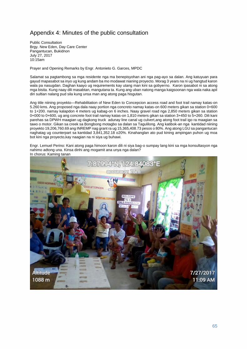
65
Appendix 4: Minutes of the public consultation Public Consultation Brgy. New Eden, Day Care Center Pangantucan, Bukidnon July 27, 2017 10:15am Prayer and Opening Remarks by Engr. Antonieto G. Garces, MPDC Salamat sa pagtambong sa mga residente nga ma benepisyohan ani nga pag-ayo sa dalan. Ang katuyuan para gayud mapasabot sa inyo ug kung andam ba mo modawat nianing proyecto. Morag 3 years na ni ug hangtud karon wala pa nasugdan. Daghan kaayo ug requirements kay utang man kini sa gobyerno. Karon ipasabot ni sa atong mga bisita. Kung naay dili masabtan, mangutana ta. Kung ang uban natong manga kaigsoonan nga wala naka apil diri sultian nalang pud sila kung unsa man ang atong paga hisgutan. Ang title niining proyekto—Rehabilitation of New Eden to Concepcion access road and foot trail namay katas-on 5.260 kms. Ang proposed nga dala naay portion nga concreto namay katas-on 600 meters gikan sa station 0+600 to 1+200. namay kalapdon 4 meters ug kabag-on 6 inches. Naay gravel road nga 2,850 meters gikan sa station 0+000 to 0+600, ug ang concrete foot trail namay katas-on 1,810 meters gikan sa station 3+450 to 5+260. Dili kani parehas sa DPWH maagian ug dagkong truck adunay line canal ug culvert,ang atong foot trail igo ra maagian sa tawo o motor. Gikan sa creek sa Bongbong motagbo sa dalan sa Tagulilong. Ang katibok-an nga kantidad niining proyekto 19,206,760.69 ang INREMP nag grant ra ug 15,365,408.73 pesos o 80%. Ang atong LGU sa pangantucan naghatag ug counterpart sa kantidad 3,841,352.18 o20%. Kinahanglan ato pud kining ampingan puhon ug moa bot kini nga proyecto,kay naagian na ni siya ug buhawi. Engr. Lemuel Perino: Kani atong paga himoon karon dili ni siya bag-o sumpay lang kini sa mga konsultasyon nga nahimo adtong una. Kinsa dinhi ang mogamit ana unya nga dalan? In chorus: Kaming tanan

66
Engr. Perino: Kinsa ang wala dinhi karon nga mogamit pud sa kalsada? Opisina? Severino Dagatan (69 years old): Kanang planters sa tubo ug mogamit pud ang LGU. Sally Kilat: Ang mga taga DENR para anang NGP nga project. Kagawad Rubico Omandam: Dako tabang ang dalan paingon sa water source sa Barangay New Eden Pangantucan Water Authority (BNEPWA) ug ang kasikbit na barangay poblacion, barangay adtuyon ug barangay lantay ug diin diha gikan ang tubig nga ilang gigamit matag adlaw. Datu Teofilo Andag-um, Jr. a.k.a Datu Junie (Manobo/ Council of Elders member): Dako ug katabang ang maong dala sa turismom ug diin makita ang Migtambol falls. Ang mountain climbers labi na nga ang plano sa PAMB nga diri ang entry or exit paadto sa Mt. Kalatungan. Datu Noel M. Tingga (Council of Elders member) ang dumodoong sir. Kagawad Antonio Espinosa: Tanan lumulopyo dinhi dako ug ikatabang sa tourism ug sa mga neighboring Barangay Concepcion ug mga turista. Engr. Perino: Aduna pa bay lain nga kaayohan? Mr. Severino Dagatan: Pilot barangay ning New Eden. Kagawad Antonio Espinosa: Pagtransport sa mga produkto dili na lisod ug barato na ang gasto sa trucking, moubos nasab ang aksidente kay dili na madagma sa pag baklay kay tarong naman ang dalan. Engr. Perino: Sa mga Manobo? Naa kahay dugang nga benepisyo? Datu Junie: Ang mga bata nga IPs panahon sa pag eskwela nga sila ra ang mag baklay sa dalan, ang akong pag-umangkon hapit naanod sa tubig kay ang tubig niagi na sa tunga sa kalsada tungod kay wala nay atiman o pag ayo sa dalan. Apil na gihapon ang uban nga dili IPsmaka binipisyo sa maong dala ug ang senior citizen maglisod nasa pagbaklay u gang manga politico panahon sa ilang pangampanya makalapos na sa maong communidad. Kagawad Rubico Omandam: Sa mga emergency ang rescue dali nalang makaresponde. Engr. Perino: Naay benepisyo sa manganakay?

67
Sally: Dali maka bahada ug moabot sa Health Center. Kami taga New Zamboanga magpasalamat mi kung maayo na ang kalsada kay kada tuig mi nagpa scrape sa maong dalan. Engr. Perino: Aduna ba negatibo nga epekto? Datu Junie: Basig naay matintal og mga illegal nga pagkuha sa produkto sa kalasang kay sayon ra man pagsulod sa sakyanan. Mrs. Ediliza: Ang produkto sayon pagpagawas kay patsada naman ang dala. Ang among produktong mais, tubo, gulay ug uban pa lisod maadto sa Mercado, mapasalamaton ko kung madayon man kini nga proyekto ,morag walay negatibo para lang sa akoa. Engr. Perino: Sa sugod, moanhi ang kontraktor uban ang LGU ug maki estorya sa inyo sa mga lumad, mag recruit pud sila og tawo. Ang mga babae apil pud sila tagaan ug trabaho dili ni molampos nga kalsada kung dili apil ang mga babae sa pag trabaho ang mga IPs, kinahanglan apil sila sa trabaho dili makapasar ang kontraktor kung dili nila apilon. Magdala pud sila og mga skilled. Unsa kaha inyong mga kabalaka ani, sa ilang paghimo og kampo? Kagawad Espinosa: Kung insakto lang ang koordinasyon motabang man ang Barangay Council sapag plastar sa ilang area o pagahimoan nila ug pampo naa gayoy koordinasyon. Malipayon mi nga ang mga babae nga naay partisipasyon sa project. Engr. Parino: Ipasabot sa kontraktor ang mga kostumbre para walay malapas ang mga kontraktor. Kamo ang magpasabot sa kontraktor sa mga kostumbre o pamalaod. Sa ubang lugar, aduna pay pamuhat. Mao ba gihapon sa inyo? Datu Junie: Tanang project diri o climber before mo proceeds aduna gayod ritual. Engr. Perino: Nahuman na ba ang Contract of Usufruct? Datu Noel: Nakapirma na kami sa Usufruct Engr. Perino: Ang kanang mahitungod sa ritual naa na didto. Engr. Perino: Ang mga basura gikan sa ilang kampo? Kinsa man ang motan-aw ana diri sa barangay? Aduna baycompost pit? Sally: Ang barangay council mao ang mag tan-aw kung naa ba silay gihimo ng compost pit sir. Kagawad Espinosa: Naay programa ang barangay mahitungod sa pag segregate sa basura. Kay ang barangay nag implementar man sa Solid Waste Management, sigun sa RA 9003 (Ecological Solid Waste Management). Engr. Perino: Ang ikaduha nga ang-ang mao ang pagtrabaho sa kalsada adunay abog, problema ba kani? Kagawad Espinosa: Ang mga hubakon dili sa mag duol-duol. Engr. Perino: Mapasaylo pa bana ninyo? In chorus: Mapasaylo ra sir oi kay para man sabna sa amoa ang maong proyekto basta lang mahuman ang project. Engr. Perino: Ang kasaba? Usahay gabii kay paspas ang trabaho. In chorus: okay ra sir. Engr. Perino: Ang aso makahilo, makasamok ba kini sa inyo? Mr. Dionisio: Maanad rami ana sir dili rana maka disturbo. Datu Junie: Layo ra man pud sa mga balay. Engr. Perino: Ang mga yuta possible nga moadto sa mga kasapaan. In chorus: Wala man pud gapangisda sa maong kasapaan. Engr. Perino: Ang tubig ninyo? Di baka kompetensya sa inyo? In chorus: Libre ang tubig sa barangay New Eden naay makuhaan sa kasapaan ug walay problema sa tubig imnonon kay kusog ang tinobdan niini.

68
Engr. Perino: Inig trabaho, naay mga used oil, krudo ug uban kana makahilo pud na siya. Moadto sa sapa. Mr. Dagatan: Lumalabay paman pud na sila dili permente. Engr. Perino: Sa pagkahuman sa kalsada, sa pag ulan, kung adunay makababag sa kanal? Mr Dagatan: Ang mga barangay official mao ang mag hatag ug communication sa katawhan ng naay pagahimoon ng pahina bahin sa maong problima. In chorus: pahinaan sa tanan. Engr. Perino: Paspas na ang dagan sa motor? Aduna bay polisiya sa speed limit In chorus: Butangan og signage o adunay polisiya pagahimoon ang barangay sir. Engr. Perinon: Kung paspas ang trabaho, masirad-an ang kalsada. Mr. Dagatan: i-one way lang. Datu Junie: Ang kontraktor maghimo pud og detour para makaagi gayud. Engr. Perino: Possible ba ang sayon nga pagpagawas sa mga kalasanon? In chorus: Possible na, pero naa man mi mga Bantay Lasang diri sir. Bawal ang pagkuha sa mga ihalas nga mang hahop. Engr. Perino: Naay magbantay sa Ancestral Domain? Datu Junie: Sa tribo, naa mi Wildlife Enforcement Officer ng gitahasan sapag bantay. Engr. Perino: Sa pag ilis-ilis sa klima, possible nga malangan ang paghuman sa kalsada? Sally: Makaapekto ang pag sige ug ulan kay dili maka trabaho pero madawat ra sir, kay sugo man sa panahon dili manta kaboot ana. Engr. Perino: Kung maayo na ang kalsada, unsay epekto sa mga Manobo nga kultura? Datu Junie: Walay angay gikabalak-an ang tribo kay sa pagkonsulta sa INREMP, naghimo na sila ug FPIC labi na mahitungod sa ritual. Engr. Perino: Aduna bay maigo nga mga sagrado nga lugar? Datu Junie: Wala sir kay sa pag survey sa maong proyekto distansya raman sa kalsada, dili maigo sa maong dalan ng pagahimoon. Datu Noel: Dalan naman pud na siya daan paga ayohon lang kay lisod again. Engr. Perino: Kinsa diri ang namuyo kilid sa kalsada? Documenter’s observation: 14 participants raised their hands (picture taken)

69
Engr. Perino: Aduna bay makuhaan nga parte sa mga balay? Mga tanom? Sally: Sa tanom hinuon sir naay ma igo sama sa mais ug tubo. Kag : Naay kaimito sir. Datu Junie: Ang kaimito dili to ma igo kay kuyog manko sa pag survey sa maong dala layo raman to kay 3 ka metros man ang distansya gikan sa tunga sa dalan.

70
Arnaldo Salmorin: (Tag iya sa kaimito)50 years old nga kaimito. Engr. Perino: Base sa desinyo, ipadayon ba ang kalsada? (Picture taken)

71

72

73

74
Appendix 5: Grievance Intake Form
Grievance Intake Form
Name of Project, Subproject and Location
Project (indicate name of project) welcomes complaints, suggestions, comments and queries regarding the project implementation and its stakeholders. We encourage persons with grievance to provide their name and contact information to enable us to get in touch with you for clarification and feedback. Should you choose to include your personal details but want that information to remain confidential, please inform us by writing/typing "(CONFIDENTIAL)" above your name. Thank you.
Contact Information
Name Gender □ Male □ Female
Home Address
Age
Phone No.
City/Province Email
Complaint/Suggestion/Comment/Question Please provide the details (who, what, where and how) of your grievance below:

75
How do you want us to reach you for feedback or update on your comment/grievance?
Portion to be filled in by PPCO staff (designated Grievance Redress Mechanism Officer):
Date received:
Received through:
__ In person __ mail __ email __ fax __ phone __ sms
Name of staff who received comment/ complaint
Position of staff:
Type of Grievance:
Remarks
Signature of staff
Updates on the case:
Date: Update Updated by (Name, Signature and Designation)

76