phase i environmental site assessment and ... i environmental site assessment and limited soil...
TRANSCRIPT
2195 Faraday Avenue ♦Suite K♦Carlsbad, California 92008-7207♦ Ph: 760-431-3747♦Fax: 760-431-3748♦www.eeitiger.com
PHASE I ENVIRONMENTAL SITE ASSESSMENT
and LIMITED SOIL INVESTIGATION
Accretive Investments, Inc. Lilac Hills Ranch Development Roadway Expansion Property
Gopher Canyon Road and Interstate 15 Intersections;
Old Highway 395 from Gopher Canyon Road North to Circle R Drive, Escondido, California 92026
County Project Number: SP 3800 12-001; Lilac Hills Ranch
Environmental Log Number: 3910 12-02-003
August 23, 2012
EEI Project Number ACR-71497.2a

PHASE I ENVIRONMENTAL SITE ASSESSMENT AND LIMITED SOIL INVESTIGATION Prepared for: Mr. Jon Rilling Vice President Accretive Investments, Inc. 12275 El Camino Real, Suite 110 San Diego, California 92130 Subject property location: Lilac Hills Ranch Development Roadway Expansion Property Gopher Canyon Road and Interstate 15 Intersections; Old Highway 395 from Gopher Canyon Road North to Circle R Drive Escondido, California 92026 EEI Project Number ACR-71497.2a Prepared and Edited by:
Polly Ivers Project Scientist Reviewed by: Bernard A. Sentianin, PG 5530 Principal Geologist EEI 2195 Faraday Avenue, Suite K Carlsbad, California 92008 (760) 431-3747 EEI Project No. ACR-71497.2a
TABLE OF CONTENTS
GENERAL SUBJECT PROPERTY INFORMATION ............................................................................ i EXECUTIVE SUMMARY .........................................................................................................................ii 1.0 INTRODUCTION ................................................................................................................................. 1
1.1 Purpose ....................................................................................................................................... 1 1.2 Scope of Services ........................................................................................................................ 1 1.3 Reliance ...................................................................................................................................... 2
2.0 PHYSIOGRAPHIC SETTING ............................................................................................................ 2
2.1 Subject Property Description ...................................................................................................... 2 2.2 Topography ................................................................................................................................. 3 2.3 Regional and Local Geology ...................................................................................................... 3 2.4 Regional and Local Hydrogeology ............................................................................................. 3 2.5 Hydrologic Flood Plain Information ........................................................................................... 4
3.0 SUBJECT PROPERTY BACKGROUND ......................................................................................... 4
3.1 Subject Property Ownership ....................................................................................................... 4 3.2 Subject Property History ............................................................................................................. 4
3.2.1 Aerial Photograph and Historical Map Review .......................................................... 4 TABLE 1 - Summary of Historical Use Review .................................................................. 5 3.2.2 City/County Directories .............................................................................................. 6 3.2.3 Sanborn Fire Insurance Maps ..................................................................................... 6 3.2.4 County of San Diego Department of Planning and Land Use .................................... 6
3.3 Regulatory Database Search ....................................................................................................... 6 3.3.1 Federal Databases ....................................................................................................... 6 3.3.2 State and Regional Sources ........................................................................................ 7
3.4 Regulatory Agency Review ........................................................................................................ 9 3.4.1 Deer Springs Fire Protection District .......................................................................... 9 3.4.2 County of San Diego Department of Environmental Health....................................... 9 3.4.3 State Water Resources Control Board ........................................................................ 9 3.4.4 Department of Toxic Substances Control ................................................................... 9 3.4.5 Review of Division of Oil, Gas, and Geothermal Resources Files ........................... 10 3.4.6 National Pipeline Mapping System .......................................................................... 10
3.5 Interview with Current Property Owner ................................................................................... 10 3.6 User Provided Information ....................................................................................................... 10 3.6.1 Environmental Liens or Activity and Use Limitations .............................................. 10
3.6.2 Specialized Knowledge ............................................................................................ 10 3.6.3 Valuation Reduction for Environmental Issues ........................................................ 10 3.6.4 Presence or Likely Presence of Contamination ......................................................... 11 3.6.5 Other ......................................................................................................................... 11
3.7 Other Environmental Issues ...................................................................................................... 11 3.7.1 Asbestos-Containing Materials ................................................................................. 11 3.7.2 Lead-Based Paint ...................................................................................................... 11 3.7.3 Radon ....................................................................................................................... 12 3.7.4 Polychlorinated Biphenyls ........................................................................................ 12

TABLE OF CONTENTS (Continued)
4.0 SUBJECT PROPERTY RECONNAISSANCE ............................................................................... 13
4.1 Purpose ..................................................................................................................................... 13 4.2 Subject Property ....................................................................................................................... 13 TABLE 2 – Summary of Subject Property Reconnaissance ........................................................... 14 4.3 Adjacent Properties................................................................................................................... 15
5.0 LIMITED SOIL INVESTIGATION ................................................................................................ 15 5.1 Field Investigation .................................................................................................................... 15 5.2 Laboratory Analytical Program ................................................................................................. 16 TABLE 4 - Soil Sample Results ..................................................................................................... 16 5.3 Discussion of Testing Results ................................................................................................... 16 6.0 FINDINGS AND OPINIONS ............................................................................................................. 16 7.0 DATA GAPS AND DEVIATIONS FROM ASTM PRACTICES ................................................... 17
7.1 Historical Data Gaps ................................................................................................................. 17 7.2 Regulatory Data Gaps ............................................................................................................... 18 7.3 On-site Data Gaps ..................................................................................................................... 18 7.4 Deviations from ASTM Practices ............................................................................................. 18
8.0 CONCLUSIONS .................................................................................................................................. 18 9.0 REFERENCES .................................................................................................................................... 19
FIGURES:
Figure 1 – Site Location Map Figure 2 – Aerial Site Map Figure 3 – Soil Boring Location Map
APPENDICES: Appendix A – Résumé of Environmental Professional
Appendix B – Roadway Expansion Figures/FIRM Map Appendix C – Historical Aerial Photographs/Topographic Maps Appendix D – Environmental Records Search Appendix E – User Provided Information Appendix F – Photographic Log Appendix G – Limited Soil Investigation Laboratory Report and Chain of Custody
i
GENERAL SUBJECT PROPERTY INFORMATION Project Information: Roadway Expansion Property EEI Project Number: ACR-71497.2a Subject Property Information: Lilac Hills Ranch Development Gopher Canyon Road and Interstate 15 Intersections; Old Highway 395 from Gopher Canyon Road North to Circle R Drive Escondido, California 92026 Subject Property Access Contact: Mr. Jon Rilling, Accretive Investments, Inc. (858) 345-3644 Consultant Information: EEI 2195 Faraday Avenue, Suite K Carlsbad, California 92008 Phone: (760) 431-3747 Fax: (760) 431-3748 E-mail Address of Environmental Professional: [email protected] Inspection Date: July 3, 2012 / Report Date: August 23, 2012 Client Information: Mr. Jon Rilling Vice President Accretive Investments, Inc. 12275 El Camino Real, Suite 110 San Diego, California 92130 Site Assessor: Ed Lump – Senior Project Manager EP Certification: I declare that, to the best of my professional knowledge and belief, I meet the definition of Environmental Professional as defined in 40 CFR 312.10 (Resume, Appendix A).
Polly Ivers – Project Scientist AAI Certification: We have the specific qualifications based on education, training, and experience to assess a property of the nature, history, and setting of the subject property. We have developed and performed the all appropriate inquiries in conformance with the standards and practices set forth in 40 CFR Part 312.
Polly Ivers – Project Scientist

Phase I ESA and Limited Soil Investigation August 23, 2012 Accretive Investments, Inc., Roadway Expansion Property, Escondido, CA EEI Project No. ACR-71497.2a
ii
EXECUTIVE SUMMARY At the request and authorization of Accretive Investments, Inc. (“Client”), EEI conducted a Phase I Environmental Site Assessment (ESA) for the proposed roadway expansion property including: the southbound I-15 off ramp to Gopher Canyon Road; the northbound Interstate 15 (I-15) off ramp to Gopher Canyon Road; the intersection of Gopher Canyon Road and Old Highway 395; and the property encompassing 50 feet west of, and 30 feet east of the current pavement of Old Highway 395 from Gopher Canyon Road north to Circle R Drive, Escondido, California. The purpose of this Phase I ESA was to assess the presence or likely presence of an existing, historical, or threatened release of any hazardous substances or petroleum products into structures, soil, and/or groundwater beneath the subject property, to the extent practical (i.e., recognized environmental conditions as delineated in ASTM E1527-05). The subject property can be accessed from the intersection of I-15 and Gopher Canyon Road. The existing roadway pavement consists entirely of asphaltic concrete. Continuous concrete sidewalks do not currently exist; however, a concrete apron was observed on Circle R Drive at Old Highway 395, and short sections of concrete sidewalks exist at crosswalks located on the west and north edges of the intersection of Gopher Canyon Road and Old Highway 395. In general, the subject property is bordered by adjacent roadway property, and a mix of undeveloped and rural residential property. The majority of land along the west and east side of Old Highway 395 consist of undeveloped property, with the exception of Station 1 of the Deer Springs Fire Protection District situated near the southeasterly corner of Circle R Drive and Old Highway 395. Additionally, the All Seasons Recreation Vehicle (RV) storage facility and RV park is located west and north of the same intersection. The Moosa Canyon Water Treatment Facility (WTF) is located adjacent to the fire district property further east along Circle R Drive. Still further east along Circle R Drive, is the Castle Creek Country Club. No other development is present in the immediate site vicinity. Based on historical records such as aerial photographs, and topographic maps, Old Highway 395 and Circle R Drive were present within the site vicinity from at least 1946. In 1980, Gopher Canyon Road and I-15 were present in their current configuration. The subject property has mainly been bordered by a mix of undeveloped land, agricultural land and rural residential development throughout history. Offsite development in the site vicinity including a golf course and structural development at the northwest and southeast corners of Old Highway 395 and Circle R Drive appeared beginning in 1963. The Moosa Canyon WTF appeared along the south side of Circle R Drive, just west of the golf course in 1976. Additional structural development appeared at the northwest and southeast corner of Old Highway 395 and Circle R Drive in 1990. EEI contacted the County of San Diego, California Department of Toxic Substances Control (DTSC), State Water Resources Control Board (SWRCB), and reviewed other State and Federal databases to determine if the subject property, or any adjacent properties, were listed as hazardous waste generators, underground storage tank releases (UST), or as having other environmental concerns (i.e., spill, leak, or aboveground tank). No releases/leaks or spills were documented at the subject property on any of the databases researched. On July 3, 2012, EEI personnel conducted a reconnaissance of the subject property to physically observe the property and adjoining properties for conditions indicating a potential environmental concern. Concerns would include any evidence of contamination, distressed vegetation, petroleum-hydrocarbon staining, waste drums, illegal dumping, or improper waste storage and/or handling. No evidence of recognized environmental conditions was noted on the subject property during our site reconnaissance.

Phase I ESA and Limited Soil Investigation August 23, 2012 Accretive Investments, Inc., Roadway Expansion Property, Escondido, CA EEI Project No. ACR-71497.2a
iii
Based on the future planned widening and improvements to the roadways, off ramps and intersections, additional investigation efforts (i.e., soil sampling and analysis) were performed by EEI to further evaluate subject property soils for aerially-deposited lead from historical automotive fuel combustion. Therefore, EEI performed a limited soil investigation at the subject property. Sampling activities were conducted on July 3, 2012. A total of six (6) discrete locations (identified as HA-1 through HA-6) were chosen to provide representative coverage at the two I-15 off ramps and the intersection of Gopher Canyon Road and Old Highway 395. Eight (8) soil samples were collected along the shoulders of Old Highway 395 (identified as HA-7 through HA-14). All fourteen (14) discrete soil samples (HA-1 through HA-14) collected during this investigation were analyzed for Total Lead by United States Environmental Protection Agency (U.S. EPA) Test Method 6010B. Concentrations of total lead were detected above the laboratory detection limit in samples HA-1, HA-5, and HA-10 through HA-14. Concentrations of lead ranged from 10 milligrams per kilogram (mg/kg) (HA-13) to 150 mg/kg (HA-5). No other samples analyzed detected lead above the laboratory reporting limit (i.e., “non-detect”). EEI compared the reported lead values to the California Human Health Screening Levels (CHHSL) residential land use scenario values. The CHHSLs are concentrations of select hazardous chemicals that are used to estimate and compare reported values in soil to risk to human health. The detected lead concentrations ranging from 10 mg/kg to 150 mg/kg is less than or equal to the CHHSL residential screening level of 150 mg/kg. Furthermore, the lead concentration appears to be generally within background levels inherent to site soils (Kearney Foundation Special Report, 1996). We have performed a Phase I Environmental Site Assessment (ESA) in conformance with the scope and limitations of ASTM Designation E1527-05 for the proposed roadway expansion property including the Gopher Canyon Road and Interstate 15 intersections; and Old Highway 395 from Gopher Canyon Road north to Circle R Drive, Escondido, California. This Phase I ESA has revealed no evidence of recognized environmental conditions in connection with the property. EEI has the following comments:
• The results of our limited soil investigation (see Section 5.0 –Limited Soil Investigation) revealed concentrations of lead in the soil samples collected from the subject property at the applicable residential screening value of 150 mg/kg. Although the concentrations of lead are at the CHHSLs for residential land uses, the concentrations are within acceptable levels for reuse per Caltrans and DTSC guidance; therefore, further investigation does not appear to be warranted at this time. In addition, according to the Client, the soils from the subject property will not be relocated or reused (i.e. placed beneath a residential use area), during construction of the proposed Lilac Hills Ranch Development. However, EEI recommends that the Caltrans guidance should be considered during future construction activities and that if the soils containing elevated concentrations of lead are moved or relocated at any time, additional testing and/or mitigation may be required.

Phase I ESA and Limited Soil Investigation August 23, 2012 Accretive Investments, Inc., Roadway Expansion Property, Escondido, CA EEI Project No. ACR-71497.2a
1
1.0 INTRODUCTION 1.1 Purpose The purpose of this Phase I Environmental Site Assessment (ESA) was to assess the possible presence of recognized environmental conditions for the proposed roadway expansion property including: the southbound I-15 off ramp to Gopher Canyon Road; the northbound I-15 off ramp to Gopher Canyon Road; the intersection of Gopher Canyon Road and Old Highway 395; and property encompassing 50 feet west of, and 30 feet east of the current pavement of Old Highway 395 from Gopher Canyon Road north to Circle R Drive, Escondido, California (Figure 1). Recognized environmental conditions include those property uses that may indicate the presence or likely presence of an existing, historical, or threatened release of any hazardous substances or petroleum products into structures, soil, and/or groundwater beneath the property. The term recognized environmental conditions are not intended to include de minimis conditions that generally do not present a material risk of harm to public health or the environment and that would not be subject to enforcement actions by a regulatory agency. This ESA was performed in general conformance with the American Society for Testing and Materials (ASTM) Standard Practice for Environmental Site Assessments: Phase I Environmental Site Assessment Process, Designation E1527-05. 1.2 Scope of Services The following scope of services was conducted by EEI:
• A review of readily available documents which included topographic, geologic, and hydrogeologic conditions associated with the subject property.
• A review of readily available maps, aerial photographs, and other documents relative to historical
subject property usage and development. • A review of previous environmental reports and regulatory file information pertaining to both existing
and historic property conditions.
• A review of readily available federal, state, county, and city documents and database files concerning hazardous material storage, generation and disposal, active and inactive landfills, existing environmental concerns, and associated permits related to the subject property and/or immediately adjacent sites.
• A subject property reconnaissance to ascertain current conditions on the subject property.
• Interviews with person(s) knowledgeable of the subject property.
• A limited agricultural chemical survey, which consisted of collecting and analyzing soil samples from
the subject property.
• The preparation of this report which presents our findings, conclusions, and recommendations.

Phase I ESA and Limited Soil Investigation August 23, 2012 Accretive Investments, Inc., Roadway Expansion Property, Escondido, CA EEI Project No. ACR-71497.2a
2
1.3 Reliance This ESA has been prepared for the sole use of Accretive Investments, Inc. (Client). This assessment should not be relied upon by other parties without the express written consent of EEI and Client. Any use or reliance upon this assessment by a party other than the Client, therefore, shall be solely at the risk of such third party and without legal recourse against EEI, its employees, officers, or directors, regardless of whether the action in which recovery of damages is brought or based upon contract, tort, statute or otherwise. This assessment should not be interpreted as a statistical evaluation of the subject property, but rather is intended to provide a preliminary indication of on-site impacts from previous property usage and/or the release of hazardous materials. If no significant indicators of the presence of hazardous materials and/or petroleum contamination are encountered during this search, this does not preclude their presence. The findings in this report are based upon published geologic and hydrogeologic information, information (both documentary and oral) provided by the County of San Diego, FirstSearch® (i.e., agency database search), various state and federal agencies, and EEI’s field observations. Some of these data are subject to change over time. Some of these data are based on information not currently observable or measurable, but recorded by documents or orally reported by individuals. 2.0 PHYSIOGRAPHIC SETTING 2.1 Subject Property Description Overall, the subject project is situated along the I-15 corridor in San Diego County, north of the City of Escondido and west of the community of Valley Center. The subject property is comprised of proposed roadway improvements which include the southbound I-15 off ramp to Gopher Canyon Road; the northbound I-15 off ramp to Gopher Canyon Road; an irregular section of the intersection of Gopher Canyon Road and Old Highway 395; and, property encompassing 50 feet west of, and 30 feet east of the current pavement of Old Highway 395, between Circle R Drive to the north, and Gopher Canyon Road to the south. The subject property can be accessed from the intersection of I-15 and Gopher Canyon Road. The existing roadway pavement consists entirely of asphaltic concrete. Continuous concrete sidewalks do not currently exist; however, a concrete apron was observed on Circle R Drive at Old Highway 395, and short sections of concrete sidewalks exist at crosswalks located on the west and north edges of the intersection of Gopher Canyon Road and Old Highway 395. In general, the subject property is bordered by adjacent roadway property, and a mix of undeveloped and rural residential property. The majority of land along the west and east side of Old Highway 395 consist of undeveloped property, with the exception of Station 1 of the Deer Springs Fire Protection District situated near the southeasterly corner of Circle R Drive and Old Highway 395. Additionally, the All Seasons Recreation Vehicle (RV) storage facility and RV park is located west and north of the same intersection. The Moosa Canyon Water Treatment Facility (WTF) is located adjacent to the fire district property further east along Circle R Drive. Still further east along Circle R Drive, is the Castle Creek Country Club. No other development is present in the immediate site vicinity. Based on historical records such as aerial photographs, and topographic maps, Old Highway 395 and Circle R Drive were present within the site vicinity from at least 1946. In 1980, Gopher Canyon Road and I-15 were present in their current configuration. The subject property has mainly been bordered by a mix of undeveloped land, agricultural land and rural residential development throughout history.

Phase I ESA and Limited Soil Investigation August 23, 2012 Accretive Investments, Inc., Roadway Expansion Property, Escondido, CA EEI Project No. ACR-71497.2a
3
Offsite development in the site vicinity including a golf course and structural development at the northwest and southeast corners of Old Highway 395 and Circle R Drive appeared beginning in 1963. The Moosa Canyon WTF appeared along the south side of Circle R Drive, just west of the golf course in 1976. Additional structural development appeared at the northwest and southeast corner of Old Highway 395 and Circle R Drive in 1990. 2.2 Topography The subject property is located on the United States Geological Survey (USGS), Bonsall, 7.5-Minute Quadrangle (USGS, 2012). Overall, the subject property is located on moderately sloping terrain consisting of varying topographic relief. The Moosa Canyon Creek traverses northwest to southeast across the portion of the subject property occurring along Old Highway 395. The subject property elevation ranges from approximately 405 feet above mean sea level (amsl) at its lowest point at Moosa Canyon Creek, to approximately 475 feet bgs at its most westerly portion at the Southbound I-15 off ramp. Based on topographic relief, surface water drainage in the site vicinity appears to be predominately to the northeast from its southern portions and the southwest from its northern portions towards Moosa Canyon Creek. 2.3 Regional and Local Geology The site vicinity lies within the Peninsular Ranges Geomorphic Province of California (CGS, 2002). The Peninsular Ranges Geomorphic Province extends from the Transverse Ranges Geomorphic Province and the Los Angeles Basin, south to Baja California. This province varies in width from about 30- to 100-miles. It is bounded on the west by the Pacific Ocean, on the south by the Gulf of California and on the east by the Colorado Desert Province. The Peninsular Ranges are essentially a series of northwest-southeast oriented fault blocks. The Transverse Ranges Geomorphic Province bounds the Peninsular Ranges on the north. Major fault zones and subordinate fault zones found in the Peninsular Ranges Province typically trend in a northwest-southeast direction. The closest major faults to the subject property are the Julian segment of the Elsinore Fault zone; the Rose Canyon Fault zone; and the Coronado Bank Fault zone (including the San Diego Trough Fault). Other major faults in the region include the San Jacinto Fault zone and the San Andreas Fault zone. The San Andreas Fault zone is considered the most active fault zone and borders the northeasterly margin of the province. Geologic maps indicate the general vicinity of the subject property is underlain by Mesozoic aged (Cretaceousage) granitic rocks (Tan, 2000). Specifically, the property is underlain by Tonalite of Couser Canyon, described as a Hornblende-biotite tonalite; coarse grained and massive. This Tonalite contain some granodiorite and is characterized by an abundance of pegmatite dikes. Soils beneath the project site and vicinity have been identified by the United States Department of Agriculture – Natural Resources Conservation Service, Web Soil Survey as sandy loams of three soil series including Visalia (VaA), Fallbrook-Vista (FvE), and Vista (VvG) (USDA, 2012). Soils in these series are generally deep, moderately to well drained, and formed in material weathered from granitic rocks. 2.4 Regional and Local Hydrogeology According to the San Diego Regional Water Quality Control Board (SDRWQCB, 1994), the subject property is located within the groundwater designation of the Bonsall Subarea (HSA – 903.12), which is a part of the lower San Luis Hydrologic Area (HA – 903.10) and located within the San Luis Rey Hydrologic Unit (HU – 903.00). Groundwater beneath the San Luis HA has been identified as having existing beneficial uses for municipal, agricultural, and industrial supply processes.

Phase I ESA and Limited Soil Investigation August 23, 2012 Accretive Investments, Inc., Roadway Expansion Property, Escondido, CA EEI Project No. ACR-71497.2a
4
EEI reviewed the California Department of Water Resources, Water Data Library website (WDL, 2012) for additional information pertaining to groundwater and water supply wells on or close to the subject property. According to the website, there are three water supply wells located within the immediate site vicinity. The depth to groundwater data for the wells ranges from 4 feet below ground surface (bgs) near the intersection of Gopher Canyon Road and Old Highway 395 (Well No. 11S03W01C004S last measured in 1966), to 46 feet bgs near the intersection of Gopher Canyon Road and the I-15 Southbound off ramp (Well No. 11S03W01E001S last measured in 1966). Based on information obtained for a nearby underground storage tank release site, Circle R Ranch Trading Post (8751 Old Castle Road, 0.45 miles southeast of the subject property), the reported depth to groundwater in the site vicinity ranges from 17.47 feet bgs to 21.18 bgs. The groundwater flow direction was reported to be to the north-northeast to north-northwest (SWRCB, 2012). 2.5 Hydrologic Flood Plain Information EEI reviewed the Federal Emergency Management Agency (FEMA, 2012) Flood Insurance Rate Map (FIRM) online database to determine if the subject property was in a flood zone. According to the information reviewed on FIRM 06073C0493G Panel 493 of 2375 (revised May 2012), the I-15 Southbound and Northbound off ramp portions of the subject are situated within Zone X. Zone X is designated as being areas of 500-year flood; areas of 100-year flood with average depths of less than one foot or with drainage areas less than one square mile, and areas protected by levees from 100-year flood. According to FIRM 06073C0494G Panel 494 of 2375 (revised May 2012), portions of the subject property located along Old Highway 395, which traverses Moosa Canyon Creek, are situated within Zone A. Zone A are areas subject to inundation by the 1-percent-annual-chance flood event generally determined using approximate methodologies. Because detailed hydraulic analyses have not been performed, no Base Flood Elevations (BFEs) or flood depths are shown. Mandatory flood insurance purchase requirements and floodplain management standards apply. Copies of the FIRM’s are included in Appendix B. 3.0 SUBJECT PROPERTY BACKGROUND 3.1 Subject Property Ownership Given that the subject property consists of vacant land associated with a proposed existing roadway expansion project, the property owner information was not readily available. 3.2 Subject Property History EEI reviewed readily available information sources to evaluate historic land use in and around the subject property. These information sources include information from aerial photographs, USGS maps and the County of San Diego. The information sources reviewed is summarized in the following sections.
3.2.1 Aerial Photograph and Historical Map Review Aerial photographs and historical topographical maps were reviewed to identify historical land development and any surface conditions which may have impacted the subject property. Photographs and historical topographic maps dating 1946, 1948, 1951, 1953, 1963, 1968, 1975, 1976, 1980, 1990/91, 2002, 2008, and 2012 were obtained and reviewed from Track Info Services/FirstSearch®, an environmental information/database retrieval service. A 2010 aerial photograph was obtained from Google Earth®. and reviewed, a copy of which is included herein (Figure 2).

Phase I ESA and Limited Soil Investigation August 23, 2012 Accretive Investments, Inc., Roadway Expansion Property, Escondido, CA EEI Project No. ACR-71497.2a
5
Table 1 summarizes the results of the historical use review. Copies of the aerial photographs and historical topographic maps provided by Track Info Services/FirstSearch® are included in Appendix C. According to the information reviewed, Old Highway 395 and Circle R Drive were present within the site vicinity from at least 1946. In 1980, Gopher Canyon Road and I-15 were present in their current configuration. The subject property has mainly been bordered by a mix of undeveloped land, agricultural land and rural residential development throughout history. Offsite development in the site vicinity including a golf course and structural development at the northwest and southeast corners of Old Highway 395 and Circle R Drive appeared beginning in 1963. The Moosa Canyon WTF appeared along the south side of Circle R Drive, just west of the golf course in 1976. Additional structural development appeared at the northwest and southeast corner of Old Highway 395 and Circle R Drive in 1990.
TABLE 1 Summary of Historical Use Review
Year Source and Scale Comments
1946 Aerial
Photograph 1:340
Old Highway 395 was present. Circle R Drive was present but did not extend west to meet with Old Highway 395. Old Castle Road was present to the south. Another road ran north to south along the west side of Old Highway 395. Site vicinity appeared as a mix of undeveloped and agricultural land.
1948/1951 Topographic
Map 1:24,000
Old Highway 395 was preset. Circle R Drive was present but did not extend west enough to intersect with Old Highway 395. Another road was present paralleling the west side of Old Highway 395 from north to south. Circle R Ranch was present along the western end of Circle R Drive. Moose Canyon Creek was noted traversing the immediate site vicinity.
1953 Aerial
Photograph 1:340
No apparent changes were noted on the site vicinity; with the exception of increased agricultural development in the area.
1963 Aerial
Photograph 1:340
No apparent changes were noted on the site vicinity; with the exception of increased rural residential and agricultural development in the area. Structural development appeared at the northwest and southeast corners of Old Highway 395 and Circle R Drive. A golf course also appeared to the east along Circle R Drive.
1968/1975 Topographic
Map 1: 24,000
No apparent changes were noted on the subject property or adjacent property. Old Castle Road was preset to the south. A golf course was present east of Circle R Drive and Old Highway 395.
1976 Aerial
Photograph 1:340
No apparent changes were noted on the site vicinity. Moosa Canyon WTF appeared along Circle R Drive to the east.
1980 Aerial
Photograph 1:340
I-15 appeared under construction to the west of Old Highway 395. Gopher Canyon Road appeared in its current configuration. Portions of the subject property along the west side of Old Highway 395 appeared cleared of vegetation.
1990and 1991
Aerial Photograph
1:340
Circle R Drive now extended west and intersected with Old Highway 395. I-15 now appeared completed. Additional structures now present at the northwest and southeast corner of Circle R Drive and Old Highway 395.
2002/2008 Aerial
Photograph 1:340
No apparent changes were noted in the site vicinity. Additional development appeared to the north along Old Highway 395.

Phase I ESA and Limited Soil Investigation August 23, 2012 Accretive Investments, Inc., Roadway Expansion Property, Escondido, CA EEI Project No. ACR-71497.2a
6
TABLE 1 Summary of Historical Use Review
Year Source and Scale Comments
August 2010
Aerial Photograph Accretive
Investments, Inc.
The subject property appeared in its current configuration. Structures and the Moosa Canyon WTF were present at the southeast corner of Circle R Drive and Old Highway 395, while structures (RV Park) remained at the northwest corner. Castle Creek Country Club and Golf Course was present to the east of the sewer station. A mix of agricultural land and rural residential development appeared in the site vicinity.
2012 Topographic
Map 1:24,000
I-15 now ran parallel on the west side of Old Highway395. The Circle R A golf course and RV Park was indicated near Circle R Drive and Old Highway 395.
3.2.2 City/County Directory Due to the absence of structural development on the subject property, and therefore, the lack of directory information, as well as the agricultural and rural residential land uses of the surrounding area, this information source was not researched as it was not deemed to be sufficiently useful. 3.2.3 Sanborn Fire Insurance Maps
Sanborn Fire Insurance maps were developed in the late 1800s and early 1900s for use as an assessment tool for fire insurance rates in urbanized areas. An on-line search was made at the Los Angeles County Public Library’s collection of Sanborn Fire Insurance maps (LAPL, 2012). Sanborn map coverage was not available for the subject property and/or surrounding area; therefore, indicating little or no development prior to the 1950s. 3.2.4 County of San Diego Department of Planning and Land Use Due to the absence of structural development on the subject property, and therefore, the lack of any associated address or building permit records, this information source was not researched as it was not deemed to be sufficiently useful.
3.3 Regulatory Database Search EEI reviewed known electronic database listings for possible hazardous waste generating establishments in the vicinity of the subject property, as well as adjacent sites with known environmental concerns. Facilities were identified by county, state, or federal agencies that generate, store, or dispose of hazardous materials. The majority of information in this section was obtained from FirstSearch®, an environmental information/database retrieval service. A copy of the FirstSearch® report is provided in Appendix D, along with a description of the individual databases. The subject property was not listed on any of the databases researched.
3.3.1 Federal Databases National Priority List (NPL) – No listings were reported within one mile of the subject property. NPL Delisted – No listings were reported within one-half mile of the subject property.

Phase I ESA and Limited Soil Investigation August 23, 2012 Accretive Investments, Inc., Roadway Expansion Property, Escondido, CA EEI Project No. ACR-71497.2a
7
Comprehensive Environmental Response, Compensation, and Liability Information System (CERCLIS) – No listings were reported within one-half mile of the subject property. CERCLIS (NFRAP) Archive – No listings were reported within one-half mile of the subject property. Resource Conservation and Recovery Information System (RCRA) Corrective Action Sites (COR) – No listings were reported within one mile of the subject property. RCRA TSD Facility List (RCRA-D) – No listings were reported within one-half mile of the subject property. RCRA Generators (RCRA-G) – No listings were reported within one-quarter mile of the subject property. RCRA No Longer Regulated (NLR) – No listings were reported within one-eighth mile of the subject property. Federal Brownfield – No listings were reported within one-quarter mile of the subject property. Emergency Response Notification System (ERNS) – No listings were reported within one-eighth mile of the subject property. One non-geocoded listing was reported. Upon further review, EEI determined this site to be located further than one mile from the subject property; therefore, the site is not considered an environmental concern. The subject property was not identified on any of the above-referenced databases researched. 3.3.2 State and Regional Sources Tribal Lands – No listings were reported within one mile of the subject property: One non-geocoded site was listed as Bureau of Indian Affairs Contact 1 (location unknown). Tribal lands listings are generally not locations or releases, but placeholders used to contact the local Bureau of Indian Affairs representative for information on tribal lands in the area. State/Tribal Sites – No listings were reported within one mile of the subject property. State Spills 90 – No listings were reported within one-eighth mile of the subject property. State/Tribal Solid Waste Landfill (SWL) Sites – No listings were reported within one-half mile of the subject property. State/Tribal California State Leaking Underground Storage Tanks (LUST) – Two listings for the same site were reported within one-half mile of the subject property. EEI reviewed the on-line database GeoTracker, which provides records on LUSTs, maintained by the SWRCB, for more information regarding the case.

Phase I ESA and Limited Soil Investigation August 23, 2012 Accretive Investments, Inc., Roadway Expansion Property, Escondido, CA EEI Project No. ACR-71497.2a
8
The listing, Circle R Ranch Trading Post (8751 Old Castle Road, 0.45 miles southeast of the subject property), reported a gasoline release in 1993. The case was closed by the San Diego DEH on December 3, 1996. EEI reviewed the San Diego DEH case closure summary on GeoTracker. According to the summary, food and gasoline dispensing operations were discontinued at the site in 1990. Site investigation efforts in 1994 and 1995 delineated the full extent of petroleum hydrocarbons (gasoline) in the subsurface soil and groundwater. The extent of contamination was localized in the immediate vicinity of the former USTs. In June 1996, 268 tons of contaminated soil was excavated and transported offsite for treatment. Two downgradient groundwater monitoring wells contain no detectable petroleum hydrocarbon constituents. The report stated that the depth to groundwater at the site ranges from 17.47 feet bgs to 21.18 bgs. The groundwater flow direction was reported to be to the north-northeast to north-northwest. Based on the fact that the site has been closed by a regulatory agency, this site is not considered an environmental concern. State/Tribal Permitted Underground Storage Tanks (UST)/Aboveground Storage Tanks (AST) – One listing was reported within one-quarter mile of the subject property. Moosa Water Treatment Facility (8711 Circle R Drive, located adjacent to the subject property at the southeast corner of Circle R Drive and Old Highway 395), was reported as the site of an underground diesel fuel tank which was reported as removed in 1992. Operating permits are not generally rationale for environmental concern, unless a release has occurred at the site. One of the sites was listed with a release on the LUST database, Castle Creek Country Club, and is discussed above in the LUST section. The remaining listings have not reported a release; therefore, are not considered a concern. State/Tribal IC/EC – No listings were reported within one-quarter mile of the subject property. State/Tribal Voluntary Cleanup Program Properties (VCP) – No listings were reported within one-half mile of the subject property. State/Tribal Brownfields – No listings were reported within one-half mile of the subject property. State Permits – One listing was reported within one-quarter mile of the subject property. The site was listed as the Moosa Water Treatment Facility (8711 Circle R Drive, located approximately 350 feet west the intersection of Circle R Drive and Old Highway 395). State permits are not generally rationale for environmental concern, unless a release has occurred at the site. The aforementioned site has not reported a release; therefore, is not considered a concern. State Other – No listings were reported within one-quarter mile of the subject property. Oil and Gas Wells – No listings were reported within one-quarter mile of the subject property. Federal IC/EC – Six listings were reported within one-quarter mile of the subject property. Dry Cleaners – No listings were reported within one-quarter mile of the subject property.

Phase I ESA and Limited Soil Investigation August 23, 2012 Accretive Investments, Inc., Roadway Expansion Property, Escondido, CA EEI Project No. ACR-71497.2a
9
Hazardous Waste Manifest – One listing was reported within one-quarter mile of the subject property. The site was listed as the Deer Springs Fire Protection District (8709 Circle R Drive, located adjacent to the subject property on the southeast corner of the intersection of Circle R Drive Old Highway 395). Hazardous Waste Manifest listings are not generally rationale for environmental concern, unless a release has occurred at the site. The aforementioned listing has not reported a release; therefore, is not considered a concern. The subject property was not identified on any of the above-referenced databases researched.
3.4 Regulatory Agency Review
3.4.1 Deer Springs Fire Protection District EEI contact the Deer Springs Fire Protection District (DSFPD) for information pertaining to hazardous waste releases, spills, incident, and/or inspection reports for the subject property. According to staff, the DSFPD does not hold records related to hazardous releases, spills, or UST permits and referred EEI to the County of San Diego Department of Environmental Health (see below). A search by personnel for incident or inspection reports related to the subject property revealed no records on file. 3.4.2 County of San Diego Department of Environmental Health
Due to the absence of development on the subject property, and therefore, the lack of an associated address, as well as the agricultural and rural residential land uses of the surrounding area, this information source was not researched as it was not deemed to be sufficiently useful.
3.4.3 State Water Resources Control Board
EEI reviewed the online database GeoTracker (2012), which provides records on LUSTs and Spills, Leaks, Investigation and Cleanup (SLIC) sites, which is maintained by the State Water Resources Control Board (SWRCB). The subject property was not listed on any of the databases researched. One adjacent and one nearby property were identified as closed LUST cases. The sites: Castle Creek Country Club (8797 Circle R Drive, located adjacent to the subject property on the south side of Circle R Drive, approximately 0.40 miles east of Old Highway 395), and Circle R Ranch Trading Post (8751 Old Castle Road, 0.40 miles south of the subject property), are discussed above in Section 3.3.2 LUST. EEI did not request file reviews for sites previously identified as LUST sites, as information contained in the Geotracker online files contained sufficient information, in our opinion, for the purposes of this Phase I ESA. 3.4.4 Department of Toxic Substances Control EEI reviewed the online database EnviroStor (2012), which provides records on LUSTs, SLICs, Priority cleanup sites and states sites, which is maintained by the Department of Toxic Substances Control (DTSC). Neither the subject property nor any adjacent or nearby properties were listed on any of the databases researched.

Phase I ESA and Limited Soil Investigation August 23, 2012 Accretive Investments, Inc., Roadway Expansion Property, Escondido, CA EEI Project No. ACR-71497.2a
10
3.4.5 Review of Division of Oil, Gas and Geothermal Resources Files Oil and gas wells were not observed on the subject property during our subject property reconnaissance. A review of the California Division of Oil, Gas, and Geothermal Resources Website for oil and gas fields in California and Alaska (CDOGGR, 2012) indicated no petroleum exploration or production has occurred on or immediately adjacent to the subject property (identified as within Township 11S, Range 03W, Sections 01). 3.4.6 National Pipeline Mapping System EEI reviewed the National Pipeline Mapping System (NPMS, 2012) public viewer website for gas transmission pipelines and hazardous liquid trunklines on or close to the subject property. According to the information reviewed, no pipelines are located on or in close proximity to the subject property.
3.5 Interview with Current Property Owner Based on the nature of the subject property consisting of vacant land associated with a proposed existing roadway expansion project, directive from the Client, and the fact that property owner information was not readily available, the property owner was not interviewed. Based on the information gathered from other readily available historical resources, including historic topographic maps, historic aerial photographs, and internet research, EEI does not consider the absence of this interview to effect the validity of this Phase I ESA. 3.6 User Provided Information Pursuant to ASTM E1527-05, EEI provided a Phase I ESA User Specific Questionnaire to the “user” (the person on whose behalf the Phase I ESA is being conducted), in this case, Mr. Jon Rilling, with Accretive Investments, Inc., completed the questionnaire. The User Specific Information provided by Mr. Rilling is documented below. A copy of the user specific questions (per ASTM E1527-05) with Mr. Rilling’s associated responses is included in Appendix E.
3.6.1 Environmental Liens or Activity and Use Limitations Mr. Rilling stated that he is not aware of any environmental liens, land use limitations, deed restrictions or governmental notifications relating to past or recurrent violations of environmental laws with respect to the property or any facility located on the property. 3.6.2 Specialized Knowledge Mr. Rilling did not indicate that he had any other specialized knowledge related to the subject property. 3.6.3 Valuation Reduction for Environmental Issues Mr. Rilling stated that there is no valuation reduction for environmental issues related to the subject property.
Phase I ESA and Limited Soil Investigation August 23, 2012 Accretive Investments, Inc., Roadway Expansion Property, Escondido, CA EEI Project No. ACR-71497.2a
11
3.6.4 Presence or Likely Presence of Contamination Mr. Rilling indicated that he does not know of any specific issues related to past uses, specific chemicals, spills, releases, or cleanups which may have occurred on the property. 3.6.5 Other Mr. Rilling noted that the Phase I ESA is required due to a County of San Diego Development application requirement. Mr. Rilling noted that the type of transaction is a survey for environmental planning.
3.7 Other Environmental Issues
3.7.1 Asbestos-Containing Materials
Asbestos, a natural fiber used in the manufacturing of a number of different building materials, has been identified as a human carcinogen. Most friable (i.e., easily broken or crushed) Asbestos- Containing Material (ACM) was banned in building materials by 1978. By 1989, most major manufacturers had voluntarily removed non-friable ACM (i.e., flooring, roofing, and mastics/sealants) from the market. These materials, however, were not banned completely. In October 1995, the Federal Occupational Safety and Health Administration (OSHA) redefined the manner by which building materials are classified in regards to asbestos and the also the way these materials are to be handled. Under this ruling, “thermal system insulation and sprayed-on or troweled on or otherwise applied surfacing materials” applied before 1980 are considered presumed Asbestos-Containing Materials (PACM). Other building materials such as “floor or ceiling tiles, siding, roofing, transite panels” (i.e., non-friable) are also considered PACM unless tested. An ACM survey was not conducted at the subject property as part of this Phase I ESA. The subject property consists of vacant land associated with a proposed existing roadway expansion project. Based on this information, the presence of Asbestos-Containing Materials is not considered likely. 3.7.2 Lead-Based Paint
Lead-Based Paint (LBP) is identified by OSHA, the Environmental Protection Agency (EPA) and the Department Housing and Urban Development Department (HUD) as being a potential health risk to humans, particularly children, based upon its effects to the central nervous system, kidneys, and bloodstream. The risk of Lead-Based Paint has been classified by HUD based upon the age and condition of the painted surface. This classification includes the following:
• maximum risk is from paint applied before 1950; • a severe risk is present from paint applied before 1960; • a moderate risk is present from paint applied before 1970; • a slight risk is present from paint applied before 1977; and • paint applied after 1977 is not expected to contain lead.
The subject property consists of vacant land associated with a proposed existing roadway expansion project. Based on this information, the presence of lead-based paint is not considered likely.

Phase I ESA and Limited Soil Investigation August 23, 2012 Accretive Investments, Inc., Roadway Expansion Property, Escondido, CA EEI Project No. ACR-71497.2a
12
3.7.3 Radon
Radon is a radioactive gas which has been identified as a human carcinogen. Radon gas is typically associated with fine-grained rock and soil, and results from the radioactive decay of radium. The U.S. EPA recommends that homeowners in areas with radon screening levels greater than 4 Picocuries per liter (pCi/L) conduct mitigation of radon gas to reduce exposure. Sections 307 and 309 of the Indoor Radon Abatement Act of 1988 (IRAA) directed the U.S. EPA to list and identify areas of the U.S. with the potential for elevated indoor radon levels. U.S. EPA’s Map of Radon Zones (EPA-402-R-93-071) assigns each of the 3,141 counties in the US to one of three zones based on radon potential:
• Zone 1 counties have a predicted average indoor radon screening level greater than 4 pCi/L. • Zone 2 counties have a predicted average indoor radon screening level between 2 and 4
pCi/L. • Zone 3 counties have a predicted average indoor radon screening level less than 2 pCi/L.
Based on such factors as indoor radon measurements; geology; aerial radioactivity; and soil permeability, the U.S. EPA has identified the County of San Diego as Zone 3 (i.e., a predicted average indoor radon screening level less than 2 pCi/L). EEI does not consider radon as a significant environmental concern at this time. 3.7.4 Polychlorinated Biphenyls
Polychlorinated biphenyls (PCB’s) are used in electrical equipment, particularly in capacitors and transformers, because they are electrically nonconductive and stable at high temperatures. PCB’s persist in the environment, accumulate in organisms, and concentrate in the food chain. The disposal of these compounds is regulated under the Toxic Substances Control Act, which banned the manufacture and distribution of PCB’s. By Federal definition, PCB equipment contains 500 parts per million (ppm) or more of PCB’s, where PCB-contaminated equipment contains PCB concentrations greater than 50 ppm but less than 500 ppm. The US Environmental Protection Agency (EPA), under TSCA guidance, regulates the removal and disposal of all sources of PCB’s containing 50 ppm or more. Any electrical equipment containing dielectric insulating fluids or coolants, manufactured prior to 1976, should be considered as potentially PCB-containing. This includes transformers, capacitors, and fluorescent light fittings. In addition, PCB’s may also be found as a stabilizer in older lubricating oils, pesticide extenders, cutting oils, hydraulic fluids, paints, sealants, and flame retardants (UNEP, 1999). Overhead power lines were observed predominantly along the western side of Old Highway 395 north of Circle R Drive, and along the eastern side south of the intersection; however, one overhead lateral line was detected on the west side of Old Highway 395 near the southern side of the culvert crossing. Overhead power lines were not noted along Gopher Canyon Road or the subject I-15 off ramps. Overhead electrical transformers were not readily visible. Based on our experience with similar sites surrounding the subject property and San Diego County, PCB containing pole-mounted transformers is unlikely; therefore, is not considered an environmental concern at this time.

Phase I ESA and Limited Soil Investigation August 23, 2012 Accretive Investments, Inc., Roadway Expansion Property, Escondido, CA EEI Project No. ACR-71497.2a
13
4.0 SUBJECT PROPERTY RECONNAISSANCE 4.1 Purpose The purpose of our subject property reconnaissance was to visually and physically observe the subject property, structures, and adjoining properties for conditions indicating an existing release, past release, or threatened release of any hazardous materials/substances or petroleum products into structures on the subject property, or into soil and/or groundwater beneath the subject property. This would include any evidence of contamination, distressed vegetation, petroleum-hydrocarbon surface staining, waste drums, ASTs/USTs, illegal dumping, or improper waste storage/handling. Detailed information is provided in the text below. 4.2 Subject Property On July 3, 2012, EEI personnel conducted a site reconnaissance to visually observe the subject site and adjoining properties for conditions indicating a potential recognized environmental concern. Visual conditions present during the site reconnaissance are documented in the Photographic Log (Appendix F), and summarized in Table 2. Overall, the subject project is situated along the Interstate 15 (I-15) corridor in San Diego County, north of the city of Escondido and west of the community of Valley Center. The proposed roadway improvements include the southbound I-15 off ramp to Gopher Canyon Road; the northbound I-15 off ramp to Gopher Canyon Road; the intersection of Gopher Canyon Road and Old Highway 395; and, Old Highway 395 from Gopher Canyon Road north to Circle R Drive. Existing roadway pavement consists entirely of asphaltic concrete. Continuous concrete sidewalks do not currently exist; however, a concrete apron was observed on Circle R Drive at Old Highway 395, and short sections of concrete sidewalks exist at crosswalks located on the west and north edges of the intersection of Gopher Canyon Road and Old Highway 395. The southbound I-15 off ramp intersects Gopher Canyon Road on the west side of I-15. One lane allows for a right (west) turn onto an uphill section of Gopher Canyon Road. The second lane allows for either a left turn onto a downhill section of Gopher Canyon Road or access to the I-15 on ramp to southbound I-15. Asphalt curbs are located along the edges of the off ramp. Based upon our field observations, surface expressions associated with underground utility improvements were not observed. Thin, dry weeds exist along the edges of the off ramp. The northbound I-15 off ramp intersects Gopher Canyon Road on the east side of the I-15 corridor. One lane allows for access to a right downhill turn onto Gopher Canyon Road. Another lane allows for a left run onto an uphill section of Gopher Canyon Road or access to the I-15 on ramp to northbound I-15. Underground utility improvements visible near the end of this off ramp consist of a stormdrain box inlet in the west unpaved shoulder, and a stormdrain box inlet and associated strip inlet along the east paved shoulder. Minor dry weeds were observed along the edges of the off ramp; however, the majority of the surface area beyond the pavement was earth materials. The third area of the subject project includes a section of Old Highway 395, north of Gopher Canyon Road and south of Circle R Drive. Planned improvements include both intersections. An asphaltic concrete paved carpool lot was observed at the southwesterly corner of Gopher Canyon road and Old Highway 395. Access to the lot is solely via Old Highway 395 south of the intersection. A short, concrete paved drainage swale exists across the radius curve at this southwest corner, separating the sidewalk and parking lot. Traffic lights, traffic control boxes, and traffic sensors were observed at intersection of Gopher Canyon Road and Old Highway 395.

Phase I ESA and Limited Soil Investigation August 23, 2012 Accretive Investments, Inc., Roadway Expansion Property, Escondido, CA EEI Project No. ACR-71497.2a
14
Traffic control devices observed at the intersection of Old Highway 395 and Circle R Drive consist of a stop sign on Circle R Drive. The majority of land along the west and east side of Old Highway 395 consist of undeveloped property, with the exception of Station 1 of the Deer Springs fire Protection District situated near the southeasterly corner of Circle R Drive and Old Highway 395. Additionally, an RV storage facility and RV park is located west and north of the same intersection. Additionally, field observations suggest that the majority of land on either side of Old Highway 395 is below street grade. A large diameter culvert was noted in the natural drainage crossing under a northerly portion of Old Highway 395. Vegetation in this east-west orientated drainage is well developed consisting of dense trees and brush. Utilities detected at or near the intersection of Circle R Road and Old Highway 395 include hydrants, water blow off valves, and buried cable(s). Except for a hydrant on the southerly corner of Circle R Drive, water utility improvements appeared to be concentrated along the west side of Old Highway 395. Near the southeast corner of this intersection, buried cables were noted to transition to power poles. Signs delineating a buried fiber optic cable were observed in the landscaped area at the southeast corner along the west edge of Old Highway 395 north of Circle R Drive. Overhead power lines were observed predominantly along the western side of Old Highway 395 north of Circle R Drive, and along the eastern side south of the intersection; however, one overhead lateral line was detected on the west side of Old Highway 395 near the southern side of the culvert crossing. Overhead power lines were not noted along Gopher Canyon Road or the subject I-15 off ramps. Overhead electrical transformers were not readily visible. EEI personnel conducted a reconnaissance of the property by traversing the property from north to south then east to west to physically observe the property and adjoining properties for conditions indicating a potential recognized environmental concern. Concerns would include any evidence of contamination, distressed vegetation, petroleum-hydrocarbon staining, waste drums, illegal dumping, or improper waste storage and/or handling. No evidence of recognized environmental conditions was noted on the subject property during our subject property reconnaissance efforts.
TABLE 2 Summary of Subject Property Reconnaissance
Item Concerns Comments
General Housekeeping No Minor wind-blown trash/debris observed onsite.
Surface Spills No None observed.
Stained Surfaces No A few, very minor and weathered areas of petroleum staining were observed along the unpaved shoulders on Old Highway 395.
Fill Materials No None observed. Pits/Ponds/Lagoons No None observed.
Surface Impoundments No None observed. ASTs/USTs No None observed.
Distressed Vegetation No None observed. Wetlands No A natural creek channel/culvert crossing was observed under Old Highway 395.
Electrical Substations No Electric boxes associated with the traffic lights at the intersection of Gopher Canyon Road and Old Highway 395 was observed.
Areas of Dumping No Significant piles of trash and debris were not observed on the subject property. Transformers No No mounted transformers were readily detectable within the subject property limits.
Waste/Scrap Storage No None observed. Chemical Use/Storage No None observed.

Phase I ESA and Limited Soil Investigation August 23, 2012 Accretive Investments, Inc., Roadway Expansion Property, Escondido, CA EEI Project No. ACR-71497.2a
15
4.3 Adjacent Properties On July 3, 2012, EEI personnel conducted a visual and auto reconnaissance of the adjoining neighborhoods (to the extent practical) to evaluate the potential for offsite impacts that may affect the subject property. These would include evidence of chemical storage or usage, surface staining or leakage, distressed vegetation, or evidence of illegal dumping. In general, the subject property is surrounded by rural and undeveloped land as well as the I-15 corridor easement. Access was limited to adjacent sites along Old Highway 395; however, immediately adjacent properties were not identified as having environmental related issues on any of the databases researched, and are not considered as an environmental concern at this time. No service stations, dry cleaners, or industrial properties were located in the immediate vicinity. 5.0 LIMITED SOIL INVESTIGATION The subject linear property does not appear to have been utilized for agricultural purposes. The subject property consists of major roadways/highways, including I-15 and Old Highway 395. Based on the future planned widening and improvements to the roadways, off ramps and intersections, additional investigation efforts (i.e., soil sampling and analysis) were performed by EEI to further evaluate subject property soils for aerially-deposited lead from historical automotive fuel combustion. EEI collected soil samples at an approximate 200-foot interval along Old Highway 395(on both sides of the roadway), as well as sampling each of the off ramp widening sections to I-15. The length of the Old Highway 395 expansion, including the intersections with Gopher Canyon Road and Circle R Drive, is approximately 800 feet. As a result eight (8) discrete surficial soil samples were collected (4 from each side) from the roadway shoulder along Old Highway 395, and six (6) additional samples were collected at I-15 off ramp intersections at Gopher Canyon Road. All soil samples will be submitted for laboratory analytical testing. The following sections discuss our investigation activities. 5.1 Field Investigation On July 3, 2012, EEI personnel mobilized to the subject property to conduct soil sampling activities with a stainless steel hand auger. Soil sampling locations were selected with the goal of collecting representative soil samples from the subject property. A total of six (6) discrete locations (identified as HA-1 through HA-6, Figure 3) were chosen to provide representative coverage at the two I-15 off ramps and the intersection of Gopher Canyon Road and Old Highway 395. Eight (8) soil samples were collected along the shoulders of Old Highway 395 (identified as HA-7 through HA-14, Figure 3). Individual samples were collected at a composite depth of approximately zero to six-inches below ground surface (bgs), using a hand auger. Sample material was extracted from the ground and placed in laboratory-supplied, 4-ounce glass jars. The jar was sealed with a Teflon-lined cap, and labeled with a number unique to the sample. The samples were placed in a chilled cooler and transported to EEI’s office in Carlsbad and stored in a refrigerator, where they were subsequently picked up by SunStar Labs, a California State-certified laboratory, under proper Chain-of-Custody (COC) documentation.

Phase I ESA and Limited Soil Investigation August 23, 2012 Accretive Investments, Inc., Roadway Expansion Property, Escondido, CA EEI Project No. ACR-71497.2a
16
5.2 Laboratory Analytical Testing All fourteen (14) discrete soil samples (HA-1 through HA-14) collected during this investigation were analyzed for Total Lead by United States Environmental Protection Agency (U.S. EPA) Test Method 6010B. The following bulleted items summarize the results of laboratory analytical testing:
• Concentrations of total lead were detected above the laboratory detection limit in samples HA-1, HA-5, and HA-10 through HA-14. Concentrations of lead ranged from 10 milligrams per kilogram (mg/kg) (HA-13) to 150 mg/kg (HA-5). No other samples analyzed detected lead above the laboratory reporting limit (i.e., “non-detect”).
The attached Table 3 summarizes laboratory analytical results. Complete laboratory reports and COC documentation are provided in Appendix G.
TABLE 3 Soil Sample Results
Sample ID Sample Depth (inches bgs) Date Sampled Total Lead-EPA 6010B (mg/Kg)
HA-1 0-6 7-3-2012 35 HA-2 0-6 7-3-2012 ND HA-3 0-6 7-3-2012 ND HA-4 0-6 7-3-2012 ND HA-5 0-6 7-3-2012 150 HA-6 0-6 7-3-2012 ND HA-7 0-6 7-3-2012 ND HA-8 0-6 7-3-2012 ND HA-9 0-6 7-3-2012 83
HA-10 0-6 7-3-2012 39 HA-11 0-6 7-3-2012 15 HA-12 0-6 7-3-2012 130 HA-13 0-6 7-3-2012 10 HA-14 0-6 7-3-2012 22
Laboratory Reporting Limit 3 Residential CHHSLs 150
bgs = below ground surface; CHHSL = California Human Health Screening Levels; EPA = Environmental Protection Agency; mg/kg = milligrams per kilogram; NA = Not Applicable/Analyzed; µg/kg = micrograms per kilogram.
5.3 Discussion of Testing Results The results of our limited total lead survey revealed concentrations of total lead was detected above the laboratory detection limit in samples HA-1, HA-5, and HA-10 through HA-14. Concentrations of lead ranged from 10 milligrams per kilogram (mg/kg) (HA-13) to 150 mg/kg (HA-5). No other samples analyzed detected lead above the laboratory reporting limit (i.e., “non-detect”).
Phase I ESA and Limited Soil Investigation August 23, 2012 Accretive Investments, Inc., Roadway Expansion Property, Escondido, CA EEI Project No. ACR-71497.2a
17
EEI compared the reported lead values to the California Human Health Screening Levels (CHHSL) residential land use scenario values. The CHHSLs are concentrations of select hazardous chemicals that are used to estimate and compare reported values in soil to risk to human health. The following bulleted items summarize the reported values:
• The detected lead concentrations ranging from 10 mg/kg to 150 mg/kg are less than or equal to the CHHSL residential screening level of 150 mg/kg.
6.0 FINDINGS AND OPINIONS Based on the information obtained in this ESA, EEI has the following findings and opinions:
• Known or suspected RECs – No known or suspected RECs have been identified during the preparation of this ESA: However, based on the future planned widening and improvements to the roadways, off ramps and intersections, additional investigation efforts (i.e., soil sampling and analysis) were performed by EEI to further evaluate the subject property soils for aerially-deposited lead from historical automotive fuel combustion.. Therefore, EEI performed a limited soil investigation at the subject property.
The results of our limited soil investigation (see Section 5.0 –Limited Soil Investigation) revealed concentrations of lead in the soil samples collected from the subject property at the applicable residential screening value of 150 mg/kg. Although the concentrations of lead are at the CHHSLs for residential land uses, the concentrations are within acceptable levels for reuse per Caltrans (Caltrans, 2012) and DTSC guidance; therefore, further investigation does not appear to be warranted at this time. According to the Client, the soils from the subject property will not be relocated or reused (i.e. placed beneath a residential use area), during construction of the proposed Lilac Hills Ranch Development. However, EEI recommends that the Caltrans guidance should be considered during future construction activities and that if the soils containing elevated concentrations of lead are moved or relocated at any time, additional testing and/or mitigation may be required.
• Historical REC’s – No historical REC’s have been revealed during the preparation of this ESA. • De Minimis Conditions – No de minimis conditions have been revealed during the preparation of this
ESA. 7.0 DATA GAPS AND DEVIATIONS FROM ASTM PRACTICES Section 3.2.20 (ASTM 1527-05) defines a data gap as “a lack or inability to obtain information required by the practice despite good faith efforts of the environmental professional to gather such information.” 7.1 Historical Data Gaps Based on the information obtained during the course of this investigation, the following historical data gaps were encountered.

Phase I ESA and Limited Soil Investigation August 23, 2012 Accretive Investments, Inc., Roadway Expansion Property, Escondido, CA EEI Project No. ACR-71497.2a
18
Specific Gaps Information regarding the current and past owners of the subject property was not readily available; therefore, this historical source was not researched. Resolution Efforts EEI researched historic topographic maps, historic aerial photographs, and internet research to supplement historical information. Opinions on Data Gap Significance Based on the information gathered from readily available sources, EEI does not consider the absence of this interview to effect the validity of this Phase I ESA. 7.2 Regulatory Data Gaps No regulatory data gaps were identified during our research efforts. 7.3 On-site Data Gaps No on-site data gaps were identified during our research efforts. 7.4 Deviations from ASTM Practices Section 12.10 (ASTM 1527-05), states that all deletions and deviations from this practice shall be listed individually and in detail, including Client imposed constraints, and all additions should be listed. EEI believes that there are no exceptions to, or deletions from, the ASTM Designation E1527-05 Guidelines. 8.0 CONCLUSIONS We have performed a Phase I Environmental Site Assessment (ESA) in conformance with the scope and limitations of ASTM Designation E1527-05 for the proposed roadway expansion property including the Gopher Canyon Road and Interstate 15 intersections; and Old Highway 395 from Gopher Canyon Road north to Circle R Drive, Escondido, California. This Phase I ESA has revealed no evidence of recognized environmental conditions in connection with the property. EEI has the following comments:
• The results of our limited soil investigation (see Section 5.0 –Limited Soil Investigation) revealed concentrations of lead in the soil samples collected from the subject property at the applicable residential screening value of 150 mg/kg. Although the concentrations of lead are at the CHHSLs for residential land uses, the concentrations are within acceptable levels for reuse per Caltrans and DTSC guidance; therefore, further investigation does not appear to be warranted at this time. According to the Client, the soils from the subject property will not be relocated or reused (i.e. placed beneath a residential use area), during construction of the proposed Lilac Hills Ranch Development. However, EEI recommends that the Caltrans guidance should be considered during future construction activities and that if the soils containing elevated concentrations of lead are moved or relocated at any time, additional testing and/or mitigation may be required.

Phase I ESA and Limited Soil Investigation August 23, 2012 Accretive Investments, Inc., Roadway Expansion Property, Escondido, CA EEI Project No. ACR-71497.2a
19
9.0 REFERENCES California Department of Water Resources, Water Data Library (WDL), Website (http://www.water.ca.gov/waterdatalibrary), accessed July 2012. California Division of Oil, Gas, and Geothermal Resources (CDOGGR) Website (http://maps.conservation.ca.gov/doms/index.html), accessed July 2012. California Environmental Protection Agency (CalEPA), 2005, “Use of California Human Health Screening Levels (CHHSLs) in Evaluation of Contaminated Properties.” California Geological Survey (CGS), 2002, “California Geomorphic Provinces, Note 36.” County of San Diego Land Use and Environmental Group (LUEG), KIVA, Website (http://landinfo.sdcounty.ca.gov/permit/index.cfm), accessed July 2012. Department of Toxic Substances (DTSC), Website (http://www.envirostor.dtsc.ca.gov/public/), EnviroStor database, accessed July 2012. Department of Toxic Substances Control (DTSC), 2008, “Interim Guidance for Sampling Agricultural Properties (Third Revision).” Federal Emergency Management Act (FEMA), Flood Insurance Rate Map (FIRM), Website http://msc.fema.gov/webapp/wcs/stores/servlet/FemaWelcomeView?storeId=10001&catalogId=10001&langId=-1 accessed February 2012. Los Angeles County Public Library (LAPL), Sanborn Maps 1867-1970, Website http://databases.lapl.org/#s, accessed July 2012. National Pipeline Mapping System (NPMS), Public Map Viewer Website, (https://www.npms.phmsa.dot.gov/PublicViewer/), accessed July 2012. San Diego Geographic Information Source, (SanGIS), Website, (http://files.sangis.org/interactive/viewer/viewer.asp), accessed July 2012. San Diego Regional Water Quality Control Board (SDRWQCB), 1994, “Water Quality Control Plan for the San Diego Basin (9),” dated September 8. San Francisco Bay, Regional Water Quality Control Board, Environmental Screening Levels (ESLs) (2008). State Water Resources Control Board, Website, GeoTracker database, (http://www.geotracker.swrcb.ca.gov/), accessed July 2012. Tan, Siang S., 2000, Geologic Map of the Bonsall 7.5’ Quadrangle, San Diego County, California, A Digital Database, (1:24,000), California Division of Mines and Geology (CDMG) in cooperation with the United States Geological Survey (USGS). United Nations Environmental Programme, 1999, Guidelines for the Identification of PCBs and Materials Containing PCBs.

Phase I ESA and Limited Soil Investigation August 23, 2012 Accretive Investments, Inc., Roadway Expansion Property, Escondido, CA EEI Project No. ACR-71497.2a
20
United States Department of Agriculture (USDA), Natural Resources Conservation Service, Website (http://websoilsurvey.nrcs.usda.gov/app/) Web Soil Survey, accessed July 2012. United States Geological Survey (USGS, 1975, photograph inspected 2012, Bonsall, 7.5-Minute Quadrangle.

Phase I ESA and Limited Soil Investigation August 23, 2012 Accretive Investments, Inc., Roadway Expansion Property, Escondido, CA EEI Project No. ACR-71497.2a
FIGURES

Note All Locations Are Approximate
FIGURE 1
SITE LOCATION MAPACCRETIVE INVESTMENTS, INC.
Lilac Hills Ranch
Roadway Expansion Property
Gopher Canyon Rd and Interstate 15 Intersections. and Old Hwy. 395
from Gopher Canyon Rd. North to Circle R Dr.
Escondido, California 92026
EEI Project Number ACR-71497.2a
Created July 2012
0
Scale: 1" = 1,600'
1,600FT 3,200FT960FT
APPROXIMATE
SUBJECT PROPERTY
LOCATION
Map Source: USGS, Bonsall, California 7.5 Minute Quadrangle map (USGS, 2012)

Note All Locations Are Approximate
FIGURE 2
AERIAL SITE MAP
ACCRETIVE INVESTMENTS, INC.
Lilac Hills Ranch
Roadway Expansion Property
Gopher Canyon Rd and Interstate 15 Intersections. and Old Hwy. 395
from Gopher Canyon Rd. North to Circle R Dr.
Escondido, California 92026
EEI Project Number ACR-71497.2a
Created July 2012
0
Scale: 1" = 360'
360 FT 720 FT216 FT
Fire
Station
Map Source: Google Earth®, August 23, 2010
SUBJECT
PROPERTY
BOUNDARY
All Seasons
RV Park Moosa
Canyon
WTF
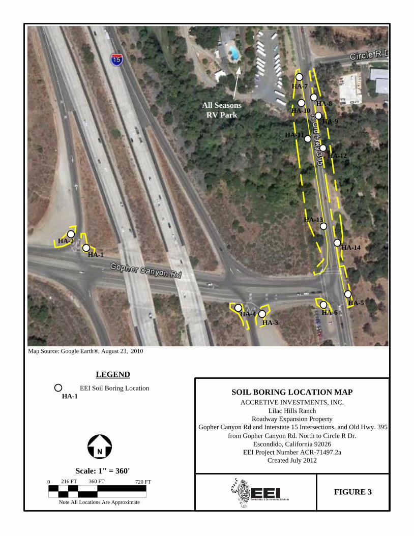
Note All Locations Are Approximate
FIGURE 3
SOIL BORING LOCATION MAP
ACCRETIVE INVESTMENTS, INC.
Lilac Hills Ranch
Roadway Expansion Property
Gopher Canyon Rd and Interstate 15 Intersections. and Old Hwy. 395
from Gopher Canyon Rd. North to Circle R Dr.
Escondido, California 92026
EEI Project Number ACR-71497.2a
Created July 2012
Map Source: Google Earth®, August 23, 2010
0
Scale: 1" = 360'
360 FT 720 FT216 FT
All Seasons
RV Park
HA-1
HA-2
HA-4
HA-3
HA-6
HA-5
HA-7
HA-8
HA-9
HA-10
HA-11
HA-12
HA-13
HA-14
LEGEND
EEI Soil Boring Location
HA-1

Phase I ESA and Limited Soil Investigation August 23, 2012 Accretive Investments, Inc., Roadway Expansion Property, Escondido, CA EEI Project No. ACR-71497.2a
APPENDIX A RESUME OF ENVIRONMENTAL PROFESSIONAL

2195 Faraday Avenue, Suite K ♦ Carlsbad, California 92008-7207 ♦ Ph: 760-431-3747 ♦ Fax: 760-431-3748 ♦ www.eeitiger.com
Polly Ivers
Project Scientist HIGHLIGHTS OF QUALIFICATIONS Experienced in project management duties for conducting field research, data collection,
inventory, analyses and report development in the Environmental Science industry. Knowledgeable of environmental compliance and regulations and technical writing
specifications for environmental documentation and regulatory reporting. Excellent communication and interpersonal skills. Diplomatic and experienced in working
with diverse populations including the public, colleagues, clients and agency representatives. Strong analytical, detail-oriented, organizational, and verbal/written communication skills. Proficient in MS Office, MS Visio, CADD, ArcGIS 9.1, Adobe Acrobat and internet research.
EDUCATION UNIVERSITY OF COLORADO, Boulder, CO B.S. Biology 1987 WETLANDS TRAINING INSTITUTE, San Diego, CA 2004 UNIVERSITY OF UTAH, Salt Lake City, UT GIS/Environmental Science Coursework 2002 - 2010 PROFESSIONAL EXPERIENCE EEI, INC., (Geotechnical and Environmental Solutions), Carlsbad, CA 2004 - Present Environmental Project Scientist (4/05 - Present) Oversee the execution and management of Phase I Environmental Site Assessments (ESA) for
over 200+ sites in California, Nevada, and Arizona. Direct Phase II limited site investigations, including Soil and Agricultural Chemical Surveys
(drilling, sampling, and monitoring). Supervised small field crews on key client projects. Assisted with Biological Assessment reports and Wetland Delineation Surveys. Manage budgets ensuring fiscal responsibility on each project. Supervise and mentor two staff members in daily duties and perform yearly peer reviews. Write ESA reports based on researched technical data. Edit and review co-worker reports. Contributed compliance documents for Environmental Impact Reports (under NEPA and
CEQA regulation) and Storm Water Pollution Prevention Plans (SWPPP).
Environmental Staff Scientist (3/04 - 3/05) Worked closely with Project Managers: conducted field visits to project sites for evaluation;
used topographic maps, aerial photographs, GPS units, and scientific tools and equipment; attended meetings; and managed project files and database.
CERTIFICATIONS 40-Hour Hazardous Waste Operations and Emergency Response (HAZWOPPER)

Phase I ESA and Limited Soil Investigation August 23, 2012 Accretive Investments, Inc., Roadway Expansion Property, Escondido, CA EEI Project No. ACR-71497.2a
APPENDIX B ROADWAY EXPANSION FIGURES/FIRM MAP


