phase i cra-092315 · phase i cultural resources assessment for the centennial park injection wells...
TRANSCRIPT

Phase I Cultural Resources Assessment for the Centennial Park Injection Wells Project
Prepared for Daniel Bott Principal Planner Orange County Water District 18700 Ward Street Fountain Valley, California 92708
Prepared by David M. Smith BonTerra Psomas 3 Hutton Centre Drive, Suite 200 Santa Ana, California 92707 T: (714) 751-7373 F: (714) 545-8883
September 2015

Centennial Park Injection Wells Project
R:\Projects\OCW_OCWD\3OCW000508\Cultural\Phase I CRA-092315.docx i Table of Contents
TABLE OF CONTENTS Section Page National Archaeological Database (NADB) Information Sheet ................................................. S-1
Management Summary ............................................................................................................. S-2
1.0 Introduction ..................................................................................................................... 1
1.1 Area of Potential Effects ........................................................................................ 1
2.0 Regulatory Setting .......................................................................................................... 1
2.1 Federal .................................................................................................................. 2
2.1.1 National Register of Historic Places .......................................................... 2
2.2 State ...................................................................................................................... 2
2.2.1 California Register of Historical Resources ............................................... 2 2.2.2 Human Remains ........................................................................................ 3
3.0 Cultural Background ....................................................................................................... 4
3.1 Prehistoric Background ......................................................................................... 4
3.2 Ethnographic Background ..................................................................................... 5
3.2.1 Gabrielino/Tongva ..................................................................................... 5 3.2.2 History........................................................................................................ 6
4.0 Methods ........................................................................................................................... 9
4.1 Archaeological Resources Records Search .......................................................... 9
4.2 Native American Heritage Commission ................................................................. 9
4.3 Paleontological Resources Records Search ......................................................... 9
4.4 Archaeological Field Survey .................................................................................. 9
5.0 Results ........................................................................................................................... 10
5.1 Records Search Results ...................................................................................... 10
5.1.1 Previous Research .................................................................................. 10 5.1.2 Current Research .................................................................................... 10
5.2 Native American Heritage Commission Records Search Results ....................... 11
5.3 Natural History Museum of Los Angeles County Review .................................... 11
5.4 Archaeological Survey Results ............................................................................ 12
6.0 Mitigation ....................................................................................................................... 13
7.0 Certification ................................................................................................................... 14
8.0 References ..................................................................................................................... 15

Centennial Park Injection Wells Project
R:\Projects\OCW_OCWD\3OCW000508\Cultural\Phase I CRA-092315.docx ii Table of Contents
TABLES
Table Page 1 Cultural Resource Investigations Within One Mile of the Project Area ........................... 10
EXHIBITS
Exhibit Follows Page 1 Centennial Park Area of Potential Effects ......................................................................... 1
APPENDICES A Cultural Resources Records Search B Native American Heritage Commission Record Search C Los Angeles Museum of Natural History Paleontological

Centennial Park Injection Wells Project
R:\Projects\OCW_OCWD\3OCW000508\Cultural\Phase I CRA-092315.docx MS-1 Executive/Management Summary
NATIONAL ARCHAEOLOGICAL DATABASE (NADB)
INFORMATION SHEET
Phase I Cultural Resources Assessment for the Centennial Park Injection Wells Project
by
David M. Smith
September 2015 Submitted by: BonTerra Psomas 3 Hutton Centre Drive, Ste. 200 Santa Ana, CA 92707 (714) 751-7373 Submitted to: Daniel Bott Principal Planner Orange County Water District 18700 Ward Street Fountain Valley, California 92708 Prepared for: CEQA Documentation USGS 7.5 Minute Orange Quadrangle BonTerra Psomas Project Number: 3OCW000508 Key Words: Centennial Park, Santa Ana River, Heritage Museum, Edinger Avenue, Godinez High School

Centennial Park Injection Wells Project
R:\Projects\OCW_OCWD\3OCW000508\Cultural\Phase I CRA-092315.docx MS-2 Executive/Management Summary
EXECUTIVE/MANAGEMENT SUMMARY
PURPOSE AND SCOPE
This report will be reviewed for federal compliance by the State Water Board and the National Park Service (SWRCB). The project site was also formerly a military communications center manage by the National Park Service. This document has been prepared to satisfy Section 106 of the National Historic Preservation Act and Section 15064.5 of the California Environmental Quality Act (CEQA) Guidelines with respect the identification and preservation of cultural resources. The OCWD will be pursuing funding through a State Revolving Fund Loan administered through the State Water Resources Control Board (SWRCB). Since the program is partially funded by the U.S. Environmental Protection Agency, the project is a federal action subject to NHPA and other federal regulations in addition to CEQA. Collectively, the SWRCB refers to these requirements as CEQA-Plus.
Cultural resources are considered during federal undertakings chiefly under Section 106 of the NHPA of 1966 (as amended) through one of its implementing regulations (36 Code of Federal Regulations [CFR] 800, Protection of Historic Properties). Properties of traditional religious and cultural importance to Native Americans are considered under Section 101(d) (6) (A) of the NHPA.
Section 106 of the NHPA (16 United States Code [USC] 470f) requires federal agencies to take into account the effects of their undertakings on any district, site, building, structure, or object that is included in or eligible for inclusion in the National Register of Historic Places (NRHP) and to afford the Advisory Council on Historic Preservation (ACHP) a reasonable opportunity to comment on such undertakings (36 CFR 800.1). Under Section 106, the significance of any adversely affected cultural resource is assessed and mitigation measures are proposed to reduce the impacts to a less than significant level. Significant cultural resources (i.e., historic properties) are those that are listed in or are eligible for listing in the NRHP in accordance with the criteria stated at 36 CFR 60.4.
The format of this report follows an amended version of the Office of Historic Preservation’s (OHP’s) Archaeological Resource Management Reports (ARMR): Recommended Contents and Format (Office of Historic Preservation 1990).
DATES OF INVESTIGATION
The BonTerra Psomas Senior Archaeologist David M. Smith conducted a cultural resources records search and literature review for the project on May 7, 2015, at the South Central Coastal Information Center (SCCIC) at California State University, Fullerton (Appendix A). Mr. Smith conducted a pedestrian/vehicular survey of the subject property on May 7, 2015. This report was completed in June 2015.The Native American Heritage Commission (NAHC) was notified of the project on May 12, 2015 and requested to review their Sacred Lands Inventory for any sacred sites that might be on or near the project area (Appendix B). Letters were sent to tribes affiliated with the project area inviting additional information on June 8, 2015. The Los Angeles County Museum of Natural History (LACM) was requested on May 7, 2015 to search their paleontological records for the project area. They responded in writing on May 28, 2015 (Appendix C).
FINDINGS OF THE INVESTIGATION
The records on file at the South Central Coastal Information Center indicate that the Heritage Museum and its ancillary structures have undergone cultural resource evaluations (Godinez EIR n.d.). Neither the museum nor the Kellogg and Maag residents are eligible for listing in the NRHP. The pedestrian/vehicular survey of the Project site did not identify any cultural resources that merited recordation. The Native American Heritage Commission search of their Sacred Lands

Centennial Park Injection Wells Project
R:\Projects\OCW_OCWD\3OCW000508\Cultural\Phase I CRA-092315.docx MS-3 Executive/Management Summary
Inventory was negative for any cultural resources recorded on or near the project site. Written requests to affiliated tribes regarding cultural resources did not result in any additional information. The project area is moderately sensitive for paleontology. No known or recorded cultural resources are located within the APE. However, because of the presence of cultural resources in the vicinity, there is a possibility that currently unknown and unrecorded cultural resources could be present in the subsurface and could be uncovered during construction activities.
FINDING OF EFFECT
No cultural resources have been recorded within the APE and none were discovered as a result of this study. Therefore, there is a finding of “No Historic Properties Affected” as a result of the construction of the Centennial Park Project.
RECOMMENDATIONS
The following mitigation measures provide the procedures necessary during construction to ensure any unanticipated impacts to unknown cultural resources are reduced to a level of no significance.
MITIGATION
1. Section 15064.5(f) of the State CEQA Guidelines states that a lead agency “should make provisions for historical or unique archaeological resources accidentally discovered during construction”. To that end, BonTerra Psomas recommends that a qualified Archaeologist be retained during construction to observe grading activities in the uppermost layers of sediment (soils and younger Quaternary Alluvium) and to salvage and catalogue archaeological resources, as necessary. The designated Archaeologist should be present during the pre-grade meeting to discuss cultural resources sensitivity and to assess whether archaeological resources have the potential to be encountered. The Archaeologist must first determine whether an archaeological resource uncovered during construction is a “unique archaeological resource” pursuant to Section 21083.2(g) of the California Public Resources Code or a “historical resource” pursuant to Section 15064.5(a) of the State CEQA Guidelines. If the archaeological resource is determined to be a “unique archaeological resource” or a “historical resource”, the Archaeologist shall formulate a mitigation plan in consultation with the OCWD that satisfies the requirements of the above-listed Sections.
2. Section 15064.5(f) of the State CEQA Guidelines states that a lead agency “should make provisions for historical or unique archaeological resources accidentally discovered during construction”. In the absence of language specific to paleontological resources, fossils must be evaluated as historical resources under eligibility Criterion 4 (potential to yield important information). Therefore, BonTerra Psomas recommends that a qualified Paleontologist be notified and retained when earth-moving activities are anticipated to impact undisturbed deposits in the Older Quaternary Alluvium on the project sites. The designated Paleontologist should be present during the pre-grade meeting to discuss paleontological sensitivity and to assess whether scientifically important fossils have the potential to be encountered. The extent of monitoring activities will be determined at the meeting in consultation with the OCWD. If any scientifically important large fossil remains are uncovered during earth-moving activities, the Paleontological Monitor will divert heavy equipment away from the fossil site until s/he has had an opportunity to examine the remains. Samples of Older Quaternary Alluvium should be collected for processing and examination for very small vertebrate fossils.

Centennial Park Injection Wells Project
R:\Projects\OCW_OCWD\3OCW000508\Cultural\Phase I CRA-092315.docx MS-4 Executive/Management Summary
3. If human remains are encountered during excavation activities, all work shall halt in the vicinity of the remains and the County Coroner shall be notified (California Public Resources Code §5097.98). The Coroner will determine whether the remains are of forensic interest. If the Coroner, with the aid of a qualified Archaeologist, determines that the remains are prehistoric, s/he will contact the Native American Heritage Commission (NAHC). The NAHC will be responsible for designating the most likely descendant (MLD), who will be responsible for the ultimate disposition of the remains, as required by Section 7050.5 of the California Health and Safety Code. The MLD shall make his/her recommendation within 48 hours of being granted access to the sites. If feasible, the recommendation of the MLD shall be followed and may include scientific removal and non-destructive analysis of the human remains and any items associated with Native American burials (California Health and Safety Code §7050.5). If the landowner rejects the recommendations of the MLD, the landowner shall rebury the remains with appropriate dignity on the property in a location that will not be subject to further subsurface disturbance (California Public Resources Code §5097.98).
DISPOSITION OF DATA
This report will be filed with the Orange County Water District, the SCCIC, and BonTerra Psomas. All field notes and other documentation related to the study are on file at BonTerra Psomas.
Centennial Park Injection Wells Project
R:\Projects\OCW_OCWD\3OCW000508\Cultural\Phase I CRA-092315.docx 1 Phase I Cultural Resources Assessment
1.0 INTRODUCTION
BonTerra Psomas was retained by the Orange County Water District (OCWD) to provide cultural resource services for the Centennial Park Injection Wells project. A total of four injection wells will be constructed at Centennial Park, which is an 87-acre community park located at 3000 West Edinger Avenue in the southwestern area of the City of Santa Ana (Exhibit 1). The park site is bound by the Santa Ana River to the west; Fairview Road and the Greenville Banning Flood Control Channel to the east; Edinger Avenue to the north; Centennial Avenue and Godinez High School to the south. Centennial Park features a combination of active and passive recreational uses that are centered around a large man-made lake. A loop road extends along the perimeter of the park site providing access to various locations in the park, including several parking areas. Each of the four injection wells will require a pipeline connection to deliver water to the injection well. The source of the water for the injection wells will be the OCWD Ground Water Recharge (GWR) System pipeline located in the western levee of the Santa Ana River. The water supply pipeline will extend from the GWR System pipeline along the nose piers of the Edinger Avenue Bridge. Once across the bridge, the pipeline will extend underground along the south side of Edinger Avenue to the entrance to Centennial Park. Within Centennial Park, the water supply pipeline will extend along the alignment of existing roads and parking lots to each injection well site. The water supply pipeline will be approximately 5,500 feet in length and will have diameters ranging from 36 inches at its connection with GWR System pipeline to 14 inches along the loop road in Centennial Park.
The Heritage Museum is south of Centennial Park along the north side of Harvard Avenue. A monitoring well is proposed for installation in an unpaved stretch of unplanted earth immediately adjacent to an asphalt driveway located behind the museum. The installation of the monitoring well will not impact the museum.
BonTerra Psomas provided a cultural resources assessment for the project to determine if project-related activities would have a significant effect on any cultural resources located on or in proximity to the Project site. None of the proposed activities will impact any known cultural resources within Centennial Park.
1.1 AREA OF POTENTIAL EFFECTS
The Area of Potential Effects (APE) consists of the Centennial Park site, Godinez High School, and the Heritage Museum site. This encompass the loop road and supply pipes, injection well sites, and one of the monitoring well sites, as well as a water supply pipeline extending from the GWR System pipeline over the Santa Ana River on Edinger Avenue Bridge to the park entrance. A monitoring well immediately west of the river is also included.
Exhibit 1 shows the APE in an aerial photograph depicting the APE boundary and project elements.
2.0 REGULATORY SETTING
This section contains a discussion of the applicable laws, ordinances, regulations, and standards that govern cultural resources and must be adhered to both prior to and during project implementation. Because the project is a federal action under the National Environmental Policy Act (NEPA) due to the need for a 404 Clean Water Act Permit from the U.S. Army Corps of Engineers, cultural resources analysis under Section 106 of the National Historic Preservation Act (16 United States Code [USC] 470f) and its implementing regulations (36 Code of Federal Regulations [CFR] 800, Protection of Historic Properties) is required.

Centennial Park Injection Wells Project
Edinger Ave
S Fair
view
Rd
Dahl Ln
Abajo
Cir
Elbert
Cir
W Dahl Ln
Berg River Cir
Moun
t Prie
to Ci
r
Carle
ton S
t
S Eve
rglad
e St
W Fordham Ave
Calendula Ave
W California St
W Carlton Pl
S Glen
arbor
St
W Maywood Ave
W Hood Ave
Loya River Ave
W Pomona St
S Sull
ivan S
tW Camden Pl
SHuronDr
S Marine St
S King St
W Castor St
W Saint Andrew Pl
SNak
oma D
r
Lilac Ave
W Anahurst Pl
W Saint Gertrude Pl
W Elder Ave
W Borchard Ave
S Ann
e St
S Sus
an S
tSA
rapah
o Dr
S Sha
wnee
Dr
W la Verne AveSMoh
awk D
r
S Yale
St
W Harvard St
W Centennial Rd
D:\Pr
ojects
\OCW
D\00
05\M
XDs\C
ultura
l\Ex_
APE_
2015
0923
.mxd
600 0 600300Feet²
Aerial Source: ESRI 2014
E-GWRS PipeP-Backflush to LakeP-Supply PipeInjection WellMonitoring WellAPE
Area of Potential Effects (APE)
(Rev: 09-23-2015 LEW) R:\Projects\OCW_OCWD\3OCW000508\Graphics\Centennial_Park\Ex1_APE_20150923.pdf
Exhibit 1

Centennial Park Injection Wells Project
R:\Projects\OCW_OCWD\3OCW000508\Cultural\Phase I CRA-092315.docx 2 Phase I Cultural Resources Assessment
2.1 FEDERAL
2.1.1 National Register of Historic Places
Cultural resources are considered during federal undertakings chiefly under Section 106 of the National Historic Preservation Act (NHPA) of 1966 (as amended) through one of its implementing regulations (36 CFR 800). Properties of traditional religious and cultural importance to Native Americans are considered under Section 101(d)(6)(A) of the NHPA.
Section 106 of the NHPA (16 USC 470f) requires federal agencies to take into account the effects of their undertakings on any district, site, building, structure, or object that is included in or eligible for inclusion in the NRHP and to afford the Advisory Council on Historic Preservation (ACHP) a reasonable opportunity to comment on such undertakings (36 CFR 800.1). Under Section 106, the significance of any adversely affected cultural resource is assessed and mitigation measures are proposed to reduce the impacts to a less than significant level. Significant cultural resources are those that are listed in or are eligible for listing in the NRHP in accordance with the criteria stated at 36 CFR 60.4, which are listed below.
The quality of significance in American history, architecture, archaeology, engineering and culture is present in districts, sites, buildings, structures, and objects that possess integrity of location, design, setting, materials, workmanship, feeling and association and that:
(a) Are associated with events that have made a significant contribution to the broad patterns of our history; or
(b) Are associated with the lives of persons significant in our past; or
(c) Embody the distinctive characteristics of a type, period, or method of installation, or that represent the work of a master, or that possess high artistic values, or that represent a significant and distinguishable entity whose components may lack individual distinction; or
(d) Have yielded, or may be likely to yield, information important in prehistory or history.
2.2 STATE
2.2.1 California Register of Historical Resources
CEQA requires a lead agency to determine whether a project would have a significant effect on one or more historical resources. A “historical resource” is defined as a resource listed in or determined to be eligible for listing in the California Register of Historical Resources (CRHR) (California Public Resources Code [PRC], Section 21084.1); a resource included in a local register of historical resources (14 California Code of Regulations [CCR], Section 15064.5[a][2]); or any object, building, structure, site, area, place, record, or manuscript that a lead agency determines to be historically significant (14 CCR 15064.5[a][3]).
Section 5024.1 of PRC, Section 15064.5 of the State CEQA Guidelines (14 CCR), and Sections 21083.2 and 21084.1 of the CEQA Statutes were used as the basic guidelines for the cultural resources study. PRC 5024.1 requires evaluation of historical resources to determine their eligibility for listing on the CRHR. The purposes of the CRHR are to maintain listings of the State’s historical resources and to indicate which properties are to be protected from substantial adverse change. The criteria for listing resources in the CRHR were expressly developed to be in accordance with criteria developed for listing in the National Register of Historic Places (NRHP)

Centennial Park Injection Wells Project
R:\Projects\OCW_OCWD\3OCW000508\Cultural\Phase I CRA-092315.docx 3 Phase I Cultural Resources Assessment
(per the criteria listed in the Code of Federal Regulations [CFR], Title 36, Section 60.4) and include those listed below.
The quality of significance in American history, architecture, archaeology, engineering and culture is present in districts, sites, buildings, structures, and objects that possess integrity of location, design, setting, materials, workmanship, feeling and association and that:
(a) Are associated with events that have made a significant contribution to the broad patterns of our history; or
(b) Are associated with the lives of persons significant in our past; or
(c) Embody the distinctive characteristics of a type, period, or method of installation, or that represent the work of a master, or that possess high artistic values, or that represent a significant and distinguishable entity whose components may lack individual distinction; or
(d) Have yielded, or may be likely to yield, information important in prehistory or history.
According to Section 15064.5(a)(3)(A–D) of the State CEQA Guidelines (14 CCR), a resource is considered historically significant if it meets the criteria for listing in the NRHP (per the criteria listed at 36 CFR 60.4 previously discussed). Impacts that affect those characteristics of the resource that qualify it for the NRHP or that would adversely alter the significance of a resource listed in or eligible for listing in the CRHR are considered to have a significant effect on the environment. Impacts to cultural resources from the proposed project are thus considered significant if the project (1) physically destroys or damages all or part of a resource; (2) changes the character of the use of the resource or physical feature within the setting of the resource that contributes to its significance; or (3) introduces visual, atmospheric, or audible elements that diminish the integrity of significant features of the resource.
The purpose of a cultural resources investigation is to evaluate whether any built environment cultural resources are present in or near the project area or can reasonably be expected to exist in the subsurface. If resources are discovered, management recommendations would be included that require evaluation of the resources for NRHP or CRHR eligibility.
2.2.2 Human Remains
Section 7050.5 of the California Health and Safety Code provides for the disposition of accidentally discovered human remains. Section 7050.5 states that, if human remains are found, no further excavation or disturbance of the site or any nearby area reasonably suspected to overlie adjacent remains shall occur until the County Coroner has determined the appropriate treatment and disposition of the human remains.
Section 5097.98 of the PRC states that, if remains are determined by the Coroner to be of Native American origin, the Coroner must notify the Native American Heritage Commission within 24 hours which, in turn, must identify the person or persons it believes to be the most likely descended from the deceased Native American. The descendants shall complete their inspection within 48 hours of being granted access to the site. The designated Native American representative would then determine, in consultation with the property owner, the disposition of the human remains.

Centennial Park Injection Wells Project
R:\Projects\OCW_OCWD\3OCW000508\Cultural\Phase I CRA-092315.docx 4 Phase I Cultural Resources Assessment
3.0 CULTURAL BACKGROUND
3.1 PREHISTORIC BACKGROUND
Several chronologies are generally used to describe the sequence of the later prehistoric periods of Southern California. William Wallace (1955) developed the first comprehensive California chronologies and defines four periods for the southern coastal region. Wallace’s synthesis is largely “descriptive and classificatory, emphasizing the content of archaeological cultures and the relationships among them” (Moratto 1984:159). Wallace relies upon the concept of “cultural horizons”, which are generally defined by the temporal and spatial distribution of a set of normative cultural traits, such as the distribution of a group of commonly associated artifact types. As a result, his model does not allow for much cultural variation within the same time period, nor does it provide precise chronological dates for each temporal division. Nonetheless, although now more than 50 years old, the Wallace chronology has provided a general framework for Southern California prehistory that remains valid today.
Horizon I: Early Man or Paleo-Indian Period (11,000 BCE to 7,500 BCE1). While initially termed Early Man Horizon (I) by Wallace (1955), this early stage of human occupation is commonly referred to as the Paleo-Indian Period today (Chartkoff and Chartkoff 1984:24). As discussed above, the precise start of this period is still a topic of considerable debate. At inland archaeological sites, the surviving material culture of this period is primarily lithic, consisting of large, extremely well made stone projectile points and tools (e.g., scrapers and choppers). Encampments were probably temporary, located near major kills or important resource areas. The San Dieguito Tradition, defined by Warren at the stratified C.W. Harris site in San Diego County, is encompassed by this period of time (Moratto 1984:97).
Horizon II: Milling Stone Assemblages (7,500 BCE to 1,000 BCE). Encompassing a broad expanse of time, the Milling Stone Period was named for the abundant millingstone tools associated with sites of this period. These tools, the mano and metate, were used to process small, hard seeds from plants associated with shrub-scrub vegetation communities. An annual round of seasonal migrations was likely practiced, with movements coinciding with ripening vegetal resources and the periods of maximal availability of various animal resources. Along the coast, shell midden sites are common site types. Some formal burials, occasionally with associated grave goods, are also evident. This period of time is roughly equivalent to Warren’s (1968) Encinitas Tradition. Warren (1968) suggests that, as millingstones are common and projectile points are comparatively rare during this period of time, hunting was less important than the gathering of vegetable resources.
More recent studies (Koerper 1981; Koerper and Drover 1983) suggest that a diversity of subsistence activities, including hunting of various game animals, were practiced during this period. At present, little is known about cultural change during this time period in Southern California. While this lack of noticeable change gives the appearance of cultural stasis, almost certainly, many regional and temporal cultural shifts did occur. Future research that is focused on temporal change in the Milling Stone Period would greatly benefit the current understanding of Southern California prehistory.
Horizon III: Intermediate Cultures (1,000 BCE to 750 CE). The Intermediate Period is identified by a mixed strategy of plant exploitation, terrestrial hunting, and maritime subsistence strategies. Chipped stone tools, such as projectile points, generally decrease in size, but increase in number. Abundant bone and shell remains have been recovered from sites dating to these time periods. In coastal areas, the introduction of the circular shell fishhook and the growing abundance of fish
1 BCE stands for “Before Common Era” and CE stands for “Common Era”. These alternative forms of “BC” and
“AD”, respectively, are used throughout this document.

Centennial Park Injection Wells Project
R:\Projects\OCW_OCWD\3OCW000508\Cultural\Phase I CRA-092315.docx 5 Phase I Cultural Resources Assessment
remains in sites over the course of the period suggest a substantial increase in fishing activity during the Intermediate Horizon. It is also during this time period that mortar and pestle use intensified dramatically. The mano and metate continued to be in use on a reduced scale, but the greatly intensified use of the mortar and pestle signaled a shift away from a subsistence strategy based on seed resources to that of the acorn. It is probably during this time period that the acorn became the food staple of the majority of the indigenous tribes in Southern California. This subsistence strategy continued until European contact. Material culture became more diverse and elaborate and included steatite containers, perforated stones, bone tools, ornamental items, and asphalt adhesive.
While Warren (1968) recognized the start of the Campbell Tradition in the Santa Barbara region at roughly the beginning of Intermediate Period, he did not see clear evidence of cultural change farther south. As a result, the Encinitas Tradition in Southern California encompasses both the Milling Stone and Intermediate Periods in Warren’s chronology (1968:2, 4). However, the more recent chronology posited by Koerper and Drover clearly recognizes an Intermediate Period within Southern California. They suggest that Warren’s inability to recognize an intermediate cultural stage was likely due to “the lack of conclusive data in 1968” (1983:26).
Horizon IV: Late Prehistoric Cultures (750 CE to 1769 CE). During the Late Prehistoric Period, exploitation of many food resources, particularly marine resources among coastal groups, continued to intensify. The material culture in the Late Prehistoric Horizon increased in complexity in terms of the abundance and diversity of artifacts being produced. The recovery and identification of a number of small projectile points during this period likely suggests a greater utilization of the bow and arrow, which was likely introduced near the end of the Intermediate Period. Shell beads, ornaments, and other elements of material culture continue to be ornate, varied, and widely distributed; the latter evidence suggests elaborate trade networks. Warren’s (1968) scheme divides the late prehistoric period into several regional traditions. Western Riverside County, Orange County, and the Los Angeles Basin area are considered part of the “Shoshonean” tradition, which may be related to a possible incursion of Takic speakers into these areas during this period. The Late Prehistoric Period includes the first few centuries of early European contact (1542–1769 CE); it is also known as the Protohistoric Period as there was a low level of interaction between native Californians and Europeans prior to Portolá’s overland expedition in 1769.
In the few centuries prior to European contact, the archaeological record reveals substantial increases in the indigenous population (Wallace 1955:223). Some village sites may have contained as many as 1,500 individuals. Apparently, many of these village sites were occupied throughout the year rather than seasonally. This shift in settlement strategy was likely influenced by improved food procurement and storage technology, which enabled population growth and may have helped stimulate changes in sociopolitical organization.
3.2 ETHNOGRAPHIC BACKGROUND
3.2.1 Gabrielino/Tongva
At the time of Spanish contact, the project area is believed to have been inhabited by the Gabrielino near the eastern extent of their ethnographic territory (see Kroeber 1925; Harrington 1933; Johnston 1962; Blackburn 1963; Heizer 1968; Bean and Smith 1978; McCawley 1996). The name “Gabrielino” identifies those people who came under the control of Mission San Gabriel Arcángel and included the inhabitants of most of current-day Los Angeles and Orange Counties and portions of Riverside and San Bernardino Counties. Today, many Gabrielino prefer to be known as Tongva. According to the ethnographic evidence, the Gabrielino territory included the coastal plain of Los Angeles and Orange Counties extending from Topanga Canyon in the north

Centennial Park Injection Wells Project
R:\Projects\OCW_OCWD\3OCW000508\Cultural\Phase I CRA-092315.docx 6 Phase I Cultural Resources Assessment
to Aliso Creek in the south, and eastward of Mount Rubidoux in Western Riverside County. Their territory also included Santa Catalina, San Clemente, and San Nicolas Islands.
Unfortunately, the Gabrielino are one of the least documented of the native peoples of California because they were one of the first groups to suffer the effects of foreign diseases brought by the Spanish and the subsequent migration of foreigners who arrived in the region (Bean and Smith 1978). Fortunately, ethnographic studies conducted by J.P. Harrington (1933), Alfred Kroeber (1925), and others in the early 20th Century provide some insight into the culture of the Gabrielino.
Linguists have determined that the Gabrielino language derived from one of the Cupan languages in the Takic family, a part of the Uto-Aztecan linguistic stock (Bean and Smith 1978). Linguistic evidence indicates that the Gabrielino or their ancestors migrated from the Great Basin area. Linguistic analysis suggests that, at one time, the entire Southern California coastal region was populated by Hokan speakers who were gradually separated and displaced by Takic-speaking immigrants from the Great Basin area (Bean and Smith 1978; Cameron 1999). The timing and extent of the migrations and their impact on indigenous peoples is not well understood, and any data related to it represents a valuable contribution to the understanding of local prehistory.
Gabrielino territory occupied one of the richest environmental habitats in all of California. The territory included four macro-environments: the Interior Mountains/Adjacent Foothills, the Prairie, the Exposed Coast, and the Sheltered Coast (Bean and Smith 1978). These diverse macro-environments, and the resources contained within each, enabled the Gabrielino to develop one of the most complex cultures of any of the native California groups. The abundance of resources provided many opportunities for the Gabrielino to exploit native plants and animals. This, in turn, allowed the population to settle in small villages throughout the territory.
Permanent villages evolved in resource-rich areas near rivers, streams, and along the coast. Secondary, or satellite, villages were also established nearby. The Gabrielino traditionally constructed two types of dwellings: the subterranean pit house and the thatched lean-to (wickiup). The pit house was constructed by excavating approximately two feet below the surface and constructing the walls and roof with wooden beams and earth around the excavation pit. The lean-to, or wickiup, was constructed of thatched walls and thatched roof, surrounded by large converging poles. A hearth located inside the structure provided warmth. Hearths used for cooking were located outside. Sweathouses, or temescals, were used as a meeting place for the men (Kroeber 1925; Bean and Smith 1978).
The material culture of the Gabrielino reflected an elaborately developed artistic style and an adaptation to the various environments within their territory. This artistic style was often manifested in elaborate shell bead and asphaltum ornamentation on many utilitarian items (e.g., bone awl handles, bowl, or mortar rims). Spear and bow and arrow were used for hunting, while manos and metates, as well as mortars and pestles, were used for processing plant and animal material into food items. The Gabrielino were also known for their high quality of basketry made from rush stems (Juncus sp.), native grass (Muhlenbergia rigens), and squawbush (Rhus trilobata) (Bean and Smith 1978:542).
3.2.2 History
The major historic periods, as defined below, for the greater Southern California area are defined by key events documented by participants, witnesses, historians, and cartographers. Paramount among these was the transfer of political control over Alta California, including the APE and surrounding lands specifically.

Centennial Park Injection Wells Project
R:\Projects\OCW_OCWD\3OCW000508\Cultural\Phase I CRA-092315.docx 7 Phase I Cultural Resources Assessment
• Spanish Period (1769–1822)
• Mexican Period (1822–1848)
• American Period (1848–Present)
Spanish explorer Juan Rodriguez Cabrillo made a temporary landfall at the Chumash village of Sisolop (present-day Ventura) on October 12, 1542 (Grant 1978:518). He was the first of several early explorers, representing several nations, to explore the Alta California coast. However, the end of the prehistoric era in Southern California is marked by the arrival of the Gaspar de Portolá overland expedition from New Spain (Mexico) and the founding of the first Spanish settlement at San Diego on July 16, 1769 (Johnston 1962). With the onset of the Spanish Period, the Gabrielino first came into direct contact with Europeans when the Portolá expedition passed through the San Gabriel Valley where the expedition camped briefly as they continued west toward Ventura (Bean and Smith 1978: 541).
Two of the 21 Franciscan missions established by the Spanish in Alta California impacted Gabrielino people profoundly: Mission San Gabriel Arcángel and Mission San Fernando Rey de España, both in Los Angeles County, which were founded in September 1771 and in 1797, respectively. The Gabrielino were persuaded to settle in the vicinity of the two missions
The missions were charged with administering to the natives within their areas. Mission life did give the Native Americans skills needed to survive in their rapidly changing world, but the population was decimated by the introduction of European diseases, such as measles and small pox, for which they had no immunity. After 1810, mission populations declined faster than they could be replenished.
The Mexican Revolution, beginning in 1821, overthrew Spanish control and the new government of Mexico had a very different outlook on mission activities. Mexico’s independence from Spain in 1822 brought the Mexican Period to California. Mexico secularized the missions in 1833 and expanded on the Spanish practice of granting large tracts of ranch land to soldiers, civil servants, and pioneers (Cleland 1966). Secularization of the missions, planned under the Spanish, was greatly accelerated by the Mexican government. Plans to provide land, training, and living quarters for the Native American population never developed and the mission lands were soon under the control of a relatively few influential Mexican families. The rancho life style was relatively short lived, but remains an influential period in California history.
During the 1840s, an increasing influx of Anglo-Americans from the eastern United States spurred an American challenge for the California territory. The American Period began with Mexico’s defeat at the end of the Mexican-American War, resulting in the concession of California to the United States under the Treaty of Guadalupe Hidalgo on February 2, 1848 (Rolle 1998:91, 104). Only a few days before, the discovery of gold on the American River had stimulated the Gold Rush of 1848–1849. After more than two years of legislative process and debate, California became the 31st state of the Union on September 9, 1850 (Rolle 1998:106).
The Spanish land grant that lay entirely in what is now Orange County, the Rancho Santiago de Santa Ana, became the location of the city of Santa Ana. The rancho was the home of two of the oldest families in California, the Yorbas and the Peraltas. Consisting of 62,516 acres, the rancho extended along the east bank of the Santa Ana River from the mountains to the sea. Settled early enough to provide homes for the third and fourth generations of the Yorbas and the Peraltas, it was eventually the location of at least 33 historic adobes. C. E. Roberts (W.P.A. Adobe project, 1936) considered it to be one of the very best examples of the California rancho.
The name is derived from two camp sites of the famed Portola expedition which passed through Orange County in July of 1769 on its way toward Monterey. Santiago stands for Saint James the

Centennial Park Injection Wells Project
R:\Projects\OCW_OCWD\3OCW000508\Cultural\Phase I CRA-092315.docx 8 Phase I Cultural Resources Assessment
Greater who was an apostle and the brother of St. John. July 29th is Saint James’ Day. Santa Ana was named for Saint Anne, the mother of the Virgin Mary. Saint Anne’s Day is on July 26. The rancho was known by various names before the American Commission decided on its official name in 1868. The petition of Yorba was for the “Paraje de Santiago”, which meant Santiago Place. Sometimes the rancho was called just “Santiago” or Santa Ana de Santiago.
The Rancho Santiago de Santa Ana stretched northerly for 25 miles, from the ocean to the mountains. Its western boundary followed the southeast bank of the Santa Ana River. The property was bow-shaped, being two and a half miles wide at the ocean end and six and a half miles wide in the middle. The land comes to a rounded point on the north end. Located midway along the southern border of the Rancho Santiago de Santa Ana, Red Hill is the point where three famous ranchos come together. From the top of Red Hill you can see lands that once belonged to the Rancho Santiago de Santa Ana, the Rancho San Joaquin, and the Rancho Lomas De Santiago (Santa Ana Historical Preservation Society 2008).
--
The Orange County Water District had its beginning in 1933. The newly formed Orange County Water District (OCWD), covering more than 163,000 acres, was authorized "to represent the water users and landowners of the Coastal Plain in all litigation involving outsiders." It was empowered to protect the water supply and the rights of those who depended upon it: 60,000 people, whose water use was 86 percent agricultural.
Fortune smiled on the District in its early years: above-average rainfall from 1937 to 1944 yielded bountiful runoff for natural recharge. In fact, some of the heaviest rain ever recorded occurred in 1938. A storm hit February 27 and did not subside until five days later. Ten inches fell on the fourth day alone, at times measuring two inches an hour. Sadly, roads and bridges washed out and 19 people perished.
By 1941, two highly significant public works projects were completed: Prado Dam and the Colorado River aqueduct. The dam became a high priority after the 1938 flood, but the aqueduct addressed a different problem: population growth in a perennially arid region. In 1942, at a time America was fully engaged in World War II, the U.S. District Court issued a judgment limiting the amount of water that upstream agencies could divert from the Santa Ana River.
As OCWD entered its second decade, groundwater was plentiful throughout the basin. Then disaster struck. A drought that began in 1945 was relieved by only two wet years until the floods came in 1969. An annual overdraft of 100,000 acre-feet brought the average groundwater level to 15 feet below sea level, and ocean water moved into the aquifers. Some wells along the coast began producing brackish water and had to be abandoned. Another world war had ended at last, but the battle of the Orange County groundwater basin was just beginning.
OCWD has grown far more extensively and rapidly than its founders could possibly have anticipated in 1933. Land has been annexed periodically through the years, as local water agencies have expanded their service areas. The District now covers well over 200,000 acres and serves a population of more than 2.4 million. And, whereas 86 percent of groundwater in 1933 was pumped for agricultural irrigation, today less than 4 percent is used on the county's disappearing farmland (OCWD 2013).
Current Conditions
Prior to 1953, the land now known as Centennial Park, was largely undeveloped. Then in the 1950’s, the United States Government established a Federal Aviation Administration Communications Center that occupied much of the land until 1967, when the first of three separate

Centennial Park Injection Wells Project
R:\Projects\OCW_OCWD\3OCW000508\Cultural\Phase I CRA-092315.docx 9 Phase I Cultural Resources Assessment
land transactions began the transfer of now so-called surplus land to private ownership, culminating with the third and final transaction in June of 1977. According to a deed restriction involving the sales, the NPS must approve proposed undertakings involving the deeded land.
One of the landowners, the City of Santa Ana, leased a sizeable portion of the property for strawberries in what would become known as the Centennial nursery. The Godinez High School, then known as the Mt. View High School, was constructed in 1968 south of where Centennial Park would be built in 1978. Two years later, in 1980, the Discovery Museum was constructed adjacent to Harvard Avenue. Subsequently, in 1986, landscaping for the museum, consisting of several small hills, was built from dredged materials from the Santa Ana River. Several years later the hallmark ponds were excavated in an area north of the pond that was to become Centennial Park as it is known today (Godinez EIR n.d.).
4.0 METHODS
4.1 ARCHAEOLOGICAL RESOURCES RECORDS SEARCH
A records search and literature review of documents on file at the South Central Coastal Information Center (SCCIC) at California State University, Fullerton was conducted on May 7, 2015 (Appendix A). The SCCIC is a designated branch of the California Historical Resources Information System and houses records regarding archaeological and historic resources in Orange, Los Angeles, Ventura and San Bernardino Counties. The review consisted of an examination of the U.S. Geological Survey’s (USGS) 7.5-minute Newport Beach Quadrangle to determine if any sites are recorded on or if any cultural resources studies have been conducted on or within a ½-mile radius of the subject property. Data sources consulted at the SCCIC included archaeological records, Archaeological Determinations of Eligibility (DOE), historic maps, and the Historic Property Data File (HPDF) maintained by the Office of Historic Preservation (OHP). The HPDF contains listings for the CRHR and/or the NRHP, California Historical Landmarks (CHL), and California Points of Historical Interest (CPHI).
4.2 NATIVE AMERICAN HERITAGE COMMISSION
The Native American Heritage Commission (NAHC) was notified of the proposed project on May 7, 2015, and requested to review their Sacred Lands Files for the presence of any cultural resources on or near the project site (Appendix B).
4.3 PALEONTOLOGICAL RESOURCES RECORDS SEARCH
The Natural History Museum of Los Angeles County (NHMLAC) was contacted and requested to review their topographical maps for the project area to determine the geology underlying the Project site, the sensitivity of the site for the presence of fossils, and if any fossil-bearing localities had been recorded (Appendix C).
4.4 ARCHAEOLOGICAL FIELD SURVEY
On May 7, 2015, BonTerra Psomas Senior Archaeologist David M. Smith conducted a vehicular/pedestrian survey of the project area. Most of the project site is entirely covered by concrete, asphalt, grass, and landscaping. Several small landscaped areas adjacent to the alignment contained exposed top soils. Those were inspected visually. A section of a drainage near the eastern edge of the park was visually inspected on foot. The remainder of the park was visually inspected via windshield survey.

Centennial Park Injection Wells Project
R:\Projects\OCW_OCWD\3OCW000508\Cultural\Phase I CRA-092315.docx 10 Phase I Cultural Resources Assessment
5.0 RESULTS
5.1 RECORDS SEARCH RESULTS
5.1.1 Previous Research
The record search at the SCCIC showed that seven cultural resource studies have been conducted within a one-mile radius of the project. Those studies consisted of pedestrian field surveys and cultural resource evaluations, or were research oriented and did not involve field work. Three of those involved the Santa Ana River Channel immediately west of the Project site. Table 1 lists the studies that were conducted near the subject property.
TABLE 1 CULTURAL RESOURCE INVESTIGATIONS WITHIN ONE MILE OF THE
PROJECT AREA
Report No. Author/Year Study Description
OR-00801* Langenwalter and Brock 1985 Phase II Prado Basin and Lower Santa Ana River
OR-01770 Bonner 1998 Cell Site Records Search and Literature Review
OR-01836* Padon 1998 Cultural Resource Review for Groundwater Replenishment
OR-03620 Wlodarski 2002 Phase I Archaeological Study Valley High School
OR-03621 Dice 2002 Archaeological Resources Assessment Fairview Street
OR-04259* Becker et al. 2007 Monitoring Report Groundwater Replenishment
OR-04388 Brunzell 2014 Cultural Resources Assessment First Harbor Project
* Study area immediately adjacent to western side of Subject site.
5.1.2 Current Research
The three studies adjacent to the project site were reviewed to determine if they contained any cultural resource information relevant to the Centennial Park area. Other than the Santa Ana River Channel, none of the three reports mention any cultural resources that are located within one mile of the project site. The river itself has not been recorded as a historic resource.
The records search indicates that no cultural resources have been recorded within a one-mile radius of the project site.
Additional data sources consulted at the SCCIC include listings of Archaeological DOE, historic maps, and the HPDF maintained by the California OHP. The HPDF contains listings for the CRHR and/or the NRHP, and the CHL. No cultural resources within the records search area were identified from any of these additional research materials.
The Heritage Museum is a 12-acre cultural and natural history center located at 3101 West Harvard Street in the southwestern area of the City of Santa Ana. The Heritage Museum site is bounded by Godinez Fundamental High School to the north and west, Mitchell Child Development Center to the east, and industrial buildings to the south. The Heritage Museum contains a historic plaza featuring several buildings from the 1890-s, extensive flora gardens, citrus groves, agriculture demonstration garden area and Native vegetation open space center located at 3101 West Harvard Street in the southwestern area of the City of Santa Ana. The Heritage Museum site is bounded by Godinez Fundamental High School to the north and west, Mitchell Child Development Center to the east, and industrial buildings to the south. The Heritage Museum contains a historic plaza featuring several buildings from the 1890-s, extensive flora gardens, citrus groves, agriculture demonstration garden area and Native vegetation open space.
Centennial Park Injection Wells Project
R:\Projects\OCW_OCWD\3OCW000508\Cultural\Phase I CRA-092315.docx 11 Phase I Cultural Resources Assessment
Two historical homes are located within the boundary of the Heritage Museum: the Maag House and the Kellogg House.
The John A. Maag House is located at 3101 West Harvard Street. The house was moved from its original location on Fairhaven Avenue to the museum property in 1980. The house was constructed in 1899 and is listed on the HPDF and was determined ineligible for the NRHP, and was not evaluated for the CRHR (CSOHP Bulletin #8: 2004). The house was not examined during the current study and its condition is unknown. It will not suffer direct impacts as a result of the proposed project.
The Kellogg House was also moved to the museum property in 1980 from its original location on Orange Avenue. The house has not been evaluated.
Lastly, it is known that a short segment of the supply pipeline will be attached to the nose piers of the Edinger Bridge that crosses the Santa Ana River Channel immediately northwest of Centennial Park. This bridge is listed in the Caltrans California Bridge Inventory (No. 55 0266). The bridge has been assigned an NRHP Status Code 5. The Bridge is not eligible for the NRHP; it underwent major construction in 2013 and 2014, and it does not warrant further consideration during this project.
5.2 NATIVE AMERICAN HERITAGE COMMISSION RECORDS SEARCH RESULTS
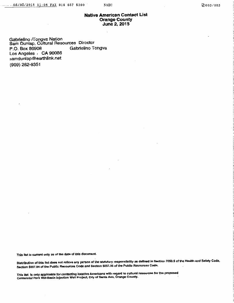
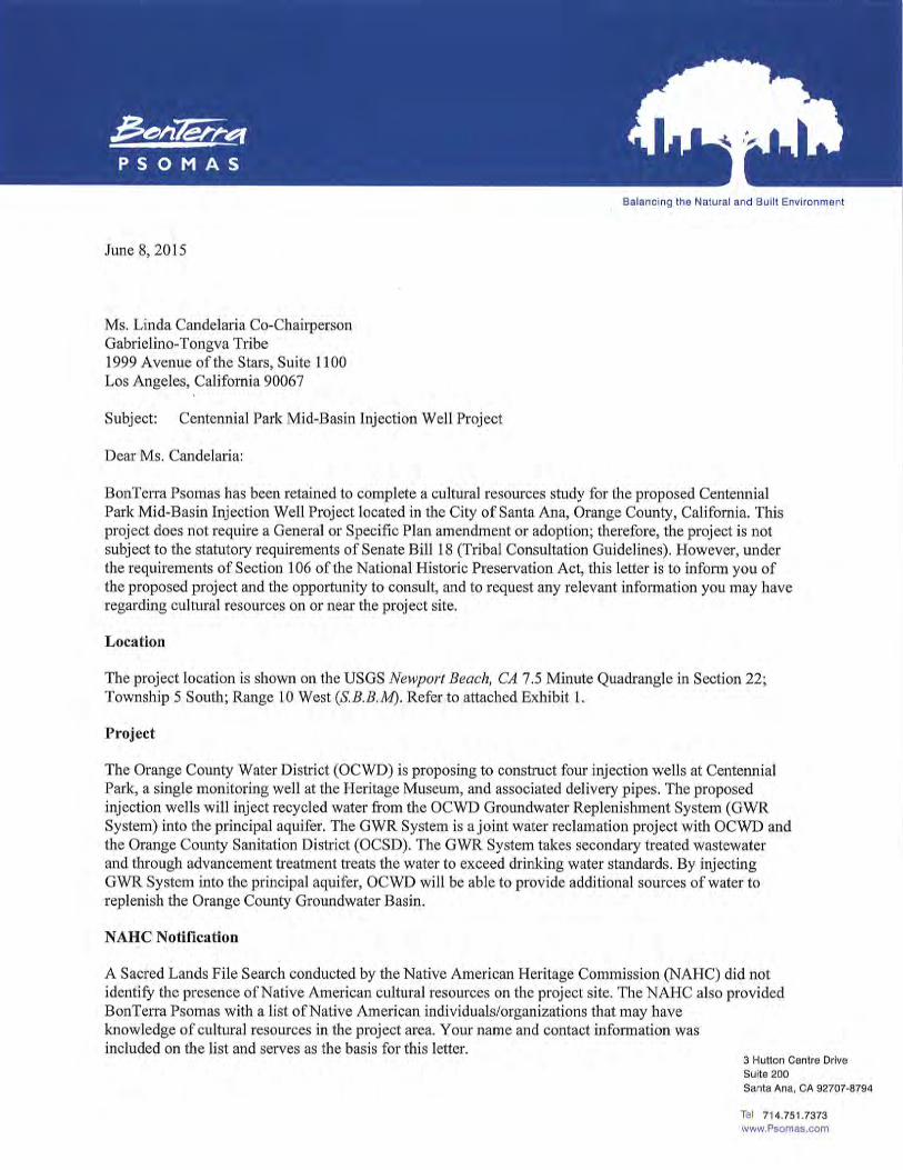
The NAHC review of the Sacred Lands Files did not show the presence of cultural resources on or near the project site (Appendix B). The NAHC acknowledged that their records might not contain all information relevant to Native American sites in the project area and advised BonTerra Psomas to contact various local tribes. The NAHC provided a list of tribes affiliated with the project site. Each tribe on the list was notified in writing on June 8, 2015, of the proposed project and invited to provide any information they may have regarding cultural resources on or near the Project site (Appendix B). No responses have been received to date.
5.3 NATURAL HISTORY MUSEUM OF LOS ANGELES COUNTY REVIEW
The NHMLAC reviewed geological maps of the project site to determine the relative paleontological sensitivity of the project site and if known fossil localities were recorded in the area. The results the review were received on June 4, 2015 (Appendix C). According to NHLMAC, the entire proposed project has surface deposits of younger Quaternary alluvium, derived as fluvial deposits from the Santa Ana River that flows through the western portion of the proposed project area. There are no fossil vertebrate localities anywhere nearby from these deposits and they are unlikely to contain significant vertebrate fossils, at least in the uppermost layers. Older Quaternary deposits may occur in the proposed project area at unknown depth, however, and contain significant fossil vertebrate remains.
The closest vertebrate fossil locality from these older Quaternary deposits is LACM 1339, just west of south of the proposed project area east of the Santa Ana River near the top of the mesa bluffs along Adams Avenue, that produced fossil specimens of mammoth (Mammuthus) and camel (Camelidae) bones from sands approximately 15 feet below the top of the mesa that is overlain by shell-bearing silts and sands. Further south and east, locality LACM 4219, along the Newport Freeway near Santa Isabel Avenue, produced fossil specimens of turtle (Testudinanta) and camel. A little further due south of the proposed project area locality LACM 3267, near the intersection of 19th Street and Anaheim Avenue, produced a specimen of a fossil elephant (Proboscidea).
Surface grading or shallow excavations in the proposed project area probably will not uncover significant vertebrate fossil remains. Excavations that extend down into the older Quaternary

Centennial Park Injection Wells Project
R:\Projects\OCW_OCWD\3OCW000508\Cultural\Phase I CRA-092315.docx 12 Phase I Cultural Resources Assessment
deposits, however, may well encounter significant fossil vertebrate specimens. Any substantial excavations below the uppermost layers in the proposed project area, therefore, should be monitored closely to quickly and professionally recover any fossil remains discovered while not impeding development. Sediment samples should also be collected and processed to determine the small fossil potential in these deposits. Any fossils recovered during mitigation should be deposited in an accredited and permanent scientific institution for the benefit of current and future generations.
5.4 ARCHAEOLOGICAL SURVEY RESULTS
The archaeological survey of the property was conducted on May 7, 2015, by Mr. David Smith, the BonTerra Psomas Senior archaeologist based out of the Orange County office. The proposed route of the pipelines, the injection and monitoring well locations, the ancillary building locations were inspected. Almost the entire route of the pipelines was obscured by grass or some form of pavement. Two of the injection locations were paved over. The monitoring well location, situated between trees in a bare area north of the museum, was inspected. No archaeological materials were observed during the pedestrian survey.
FINDINGS OF THE INVESTIGATION
The records on file at the South Central Coastal Information Center indicate that the Heritage Museum and its ancillary structures have undergone cultural resource evaluations (Godinez EIR n.d.). Neither the museum nor the Kellogg and Maag residents are eligible for listing in the NRHP. The pedestrian/vehicular survey of the Project site did not identify any cultural resources that merited recordation. The Native American Heritage Commission search of their Sacred Lands Inventory was negative for any cultural resources recorded on or near the project site. Written requests to affiliated tribes regarding cultural resources did not result in any additional information. The project area is moderately sensitive for paleontology. No known or recorded cultural resources are located within the APE. However, because of the presence of cultural resources in the vicinity, there is a possibility that currently unknown and unrecorded cultural resources could be present in the subsurface and could be uncovered during construction activities.
FINDING OF EFFECT
No cultural resources have been recorded within the APE and none were discovered as a result of this study. Therefore, there is a finding of “No Historic Properties Affected” as a result of the construction of the Centennial Park Project.

Centennial Park Injection Wells Project
R:\Projects\OCW_OCWD\3OCW000508\Cultural\Phase I CRA-092315.docx 13 Phase I Cultural Resources Assessment
6.0 MITIGATION
1. Section 15064.5(f) of the State CEQA Guidelines states that a lead agency “should make provisions for historical or unique archaeological resources accidentally discovered during construction”. To that end, BonTerra Psomas recommends that a qualified Archaeologist be retained during construction to observe grading activities in the uppermost layers of sediment (soils and younger Quaternary Alluvium) and to salvage and catalogue archaeological resources, as necessary. The designated Archaeologist should be present during the pre-grade meeting to discuss cultural resources sensitivity and to assess whether archaeological resources have the potential to be encountered. The Archaeologist must first determine whether an archaeological resource uncovered during construction is a “unique archaeological resource” pursuant to Section 21083.2(g) of the California Public Resources Code or a “historical resource” pursuant to Section 15064.5(a) of the State CEQA Guidelines. If the archaeological resource is determined to be a “unique archaeological resource” or a “historical resource”, the Archaeologist shall formulate a mitigation plan in consultation with the OCWD that satisfies the requirements of the above-listed Sections.
2. Section 15064.5(f) of the State CEQA Guidelines states that a lead agency “should make provisions for historical or unique archaeological resources accidentally discovered during construction”. In the absence of language specific to paleontological resources, fossils must be evaluated as historical resources under eligibility Criterion 4 (potential to yield important information). Therefore, BonTerra Psomas recommends that a qualified Paleontologist be notified and retained when earth-moving activities are anticipated to impact undisturbed deposits in the Older Quaternary Alluvium on the project sites. The designated Paleontologist should be present during the pre-grade meeting to discuss paleontological sensitivity and to assess whether scientifically important fossils have the potential to be encountered. The extent of monitoring activities will be determined at the meeting in consultation with the OCWD. If any scientifically important large fossil remains are uncovered during earth-moving activities, the Paleontological Monitor will divert heavy equipment away from the fossil site until s/he has had an opportunity to examine the remains. Samples of Older Quaternary Alluvium should be collected for processing and examination for very small vertebrate fossils.
3. If human remains are encountered during excavation activities, all work shall halt in the vicinity of the remains and the County Coroner shall be notified (California Public Resources Code §5097.98). The Coroner will determine whether the remains are of forensic interest. If the Coroner, with the aid of a qualified Archaeologist, determines that the remains are prehistoric, s/he will contact the Native American Heritage Commission (NAHC). The NAHC will be responsible for designating the most likely descendant (MLD), who will be responsible for the ultimate disposition of the remains, as required by Section 7050.5 of the California Health and Safety Code. The MLD shall make his/her recommendation within 48 hours of being granted access to the sites. If feasible, the recommendation of the MLD shall be followed and may include scientific removal and non-destructive analysis of the human remains and any items associated with Native American burials (California Health and Safety Code §7050.5). If the landowner rejects the recommendations of the MLD, the landowner shall rebury the remains with appropriate dignity on the property in a location that will not be subject to further subsurface disturbance (California Public Resources Code §5097.98).

Centennial Park Injection Wells Project
R:\Projects\OCW_OCWD\3OCW000508\Cultural\Phase I CRA-092315.docx 14 Phase I Cultural Resources Assessment
7.0 CERTIFICATION
I hereby certify that the statements furnished above and in the attached exhibits present the data and information required for this archaeological report, and that the facts, statements, and information presented are true and correct to the best of my knowledge and belief.
DATE: September 23, 2015 SIGNED: David M. Smith
Senior Archaeologist

Centennial Park Injection Wells Project
R:\Projects\OCW_OCWD\3OCW000508\Cultural\Phase I CRA-092315.docx 15 Phase I Cultural Resources Assessment
8.0 REFERENCES
Bean, Lowell John and Charles R. Smith 1978 Gabrielino. In Handbook of North American Indians, Vol. 8, California, pp. 538-549.
Robert F. Heizer, volume editor. Smithsonian Institution. Washington, D.C.
Blackburn, Thomas 1963 Ethnohistoric Descriptions of Gabrielino Material Culture. University of California
Archaeological Survey Annual Report 1962-1963:1–50. Los Angeles.
Brown, James T. 1985 Harvest of the Sun: An Illustrated History of Riverside County. Windsor
Publications, Northridge.
Cameron, Constance 1999 Determining Tribal Boundaries through Potsherds: An Archaeological Perspective.
Pacific Coast Archaeological Society Quarterly, Vol. 35, Numbers 2 and 3, Spring/Summer.
Chartkoff, J. L. & K. K. Chartkoff 1984 The Archaeology of California. Stanford University Press, Stanford, California.
Cleland, Robert Glass 1966 The Irvine Ranch. Huntington Library, San Marino, California.
Coy, Owen C. 1973 California County Boundaries: A Study of the Division of the State into Counties
and the Subsequent Changes in their Boundaries. Revised Edition (originally published in 1923 by the California Historical Survey Commission, Berkeley). Valley Publishers, Fresno.
Fitch, Robert J. 1993 Profile of a Century: Riverside County, California, 1893–1993. Riverside County
Historical Commission Press, Riverside.
n.d. Godinez Fundamental High School EIR
Grant, Campbell 1978 Interior Chumash. In: Handbook of North American Indians, Vol. 8, California,
Robert F. Heizer (Ed.), pp. 530–534. Smithsonian Institute, Washington, D.C.
Harrington, John P. 1933 Annotations. In: Chinigchinich: A Revised and Annotated Version of Alfred
Robinson’s Translation of Father Geronimo Boscana’s Historical Account of the Belief, Usages, Customs and Extravagancies of the Indians of this Mission of San Juan Capistrano Called the Acagchemem Tribe, edited by Phil Townsend Hanna, pp. 91–228. Fine Arts Press, Santa Ana.
Heizer, Robert F. (Ed.) 1968 The Indians of Los Angeles County: Hugo Reid’s Letters of 1852. Southwest
Museum Papers 21. Los Angeles.

APPENDIX A
CULTURAL RESOURCES RECORDS SEARCH


APPENDIX B
NATIVE AMERICAN HERITAGE COMMISSION RECORDS SEARCH

3 Hutton Centre Drive, Suite 200 Santa Ana, CA 92707-8794 • T: 714.751.7373 • F: 714.545.8883
TRANSMITTAL DATE: May 12, 2015 TO: Ms. Katy Sanchez Associate Government Program
Analyst Native American Heritage Comm. 1550 Harbor Boulevard, Ste. 100 West Sacramento, CA 95691
FAX NUMBER: (916) 657-5390 TEL NUMBER: (916) 653-6251 PROJECT: 3OCW000508 FROM: Patrick O. Maxon
Fax / Pages E-Mail Fed Ex / Overnite Express Delivery / Courier
REGARDING: Sacred Lands File Search and Contact List Request
Dear Ms. Sanchez:
BonTerra Psomas has been retained to complete a cultural resources study written to the standards of Section 106 of the National Historic Preservation Act for the proposed Centennial Park Mid-Basin Injection Well Project located in the City of Santa Ana, Orange County, California. This project does not require a General or Specific Plan amendment or adoption; therefore, the project is not subject to the statutory requirements of Senate Bill 18. At your earliest convenience, please conduct a search of the Sacred Lands File for the proposed project, located within Section 22 (Township 5 South; Range 10 West) of the USGS Newport Beach, CA 7.5 Minute Quadrangle. Refer to attached exhibit. The Orange County Water District (OCWD) is proposing to construct four injection wells at Centennial Park and a single monitoring well at the Heritage Museum. The proposed injection wells will inject recycled water from the OCWD Groundwater Replenishment System (GWR System) into the principal aquifer. The GWR System is a joint water reclamation project with OCWD and the Orange County Sanitation District (OCSD). The GWR System takes secondary treated wastewater and through advancement treatment treats the water to exceed drinking water standards. By injecting GWR System into the principal aquifer, OCWD will be able to provide additional sources of water to replenish the Orange County Groundwater Basin. Please fax the results to me at (714) 545-8883, or e-mail to [email protected], referencing your letter to the “Centennial Park Mid-Basin Injection Well Project”. If you have any questions or require any additional information, please do not hesitate to contact me at (714) 751-7373 or via email. Sincerely, BonTerra Psomas
Patrick O. Maxon, M.A., RPA Director, Cultural Resources


APPENDIX C
LOS ANGELES COUNTY MUSEUM OF NATURAL HISTORY

Vertebrate Paleontology SectionTelephone: (213) 763-3325
Fax: (213) 746-7431e-mail: [email protected]
28 May 2015
BonTerra Psomas3 Hutton Centre Drive, Suite 200Santa Ana, CA 92707
Attn: David M. Smith, Senior Archaeologist
re: Paleontological Resources for the proposed Centennial Park Project, in the City of Santa Ana,Orange County, project area
Dear David:
I have conducted a thorough search of our Vertebrate Paleontology records for theproposed Centennial Park Project, in the City of Santa Ana, Orange County, project area asoutlined on the portion of the Newport Beach USGS topographic quadrangle map that you sent tome via e-mail on 7 May 2015. We do not have any vertebrate fossil localities that lie within theproposed project area boundaries, but we do have localities nearby from the same sedimentaryunits that may occur subsurface in the proposed project area.
The entire proposed project has surface deposits of younger Quaternary Alluvium,derived as fluvial deposits from the Santa Ana River that flows through the western portion ofthe proposed project area. We have no fossil vertebrate localities anywhere nearby from thesedeposits and they are unlikely to contain significant vertebrate fossils, at least in the uppermostlayers. Older Quaternary deposits may occur in the proposed project area at unknown depth,however, and contain significant fossil vertebrate remains.
Our closest vertebrate fossil locality from these older Quaternary deposits is LACM 1339,just west of south of the proposed project area east of the Santa Ana River near the top of themesa bluffs along Adams Avenue, that produced fossil specimens of mammoth, Mammuthus,and camel, Camelidae, bones from sands approximately 15 feet below the top of the mesa that is

overlain by shell bearing silts and sands. Further south and east, our locality LACM 4219, alongthe Newport Freeway near Santa Isabel Avenue, produced fossil specimens of turtle,Testudinanta, and camel, Camelidae. A little further due south of the proposed project area ourlocality LACM 3267, near the intersection of 19 Street and Anaheim Avenue, produced ath
specimen of a fossil elephant, Proboscidea.
Surface grading or shallow excavations in the proposed project area probably will notuncover significant vertebrate fossil remains. Excavations that extend down into the olderQuaternary deposits, however, may well encounter significant fossil vertebrate specimens. Anysubstantial excavations below the uppermost layers in the proposed project area, therefore,should be monitored closely to quickly and professionally recover any fossil remains discoveredwhile not impeding development. Sediment samples should also be collected and processed todetermine the small fossil potential in these deposits. Any fossils recovered during mitigationshould be deposited in an accredited and permanent scientific institution for the benefit of currentand future generations.
This records search covers only the vertebrate paleontology records of the Natural HistoryMuseum of Los Angeles County. It is not intended to be a thorough paleontological survey ofthe proposed project area covering other institutional records, a literature survey, or any potentialon-site survey.
Sincerely,
Samuel A. McLeod, Ph.D.Vertebrate Paleontology
enclosure: invoice