pg&e topock – initial study: topock upland in situ pilot test · 2018. 12. 6. · calstars...
TRANSCRIPT

State of California – California Environmental Protection Agency Department of Toxic Substances Control
DTSC 1324 (7/27/06) 1
INITIAL STUDY PROJECT TITLE: Topock Upland In Situ Pilot Test, Aquifer Testing, Groundwater Well Maintenance And Well Decommissioning
CALSTARS CODING: 22120, 540015-48, MPC 72
PROJECT ADDRESS: Park Moabi Road and Interstate 40
CITY: Needles
COUNTY: San Bernardino
PROJECT SPONSOR: Pacific Gas and Electric Company (PG&E)
CONTACT: Curt Russell PHONE: (760) 326-5582
APPROVAL ACTION UNDER CONSIDERATION BY DTSC:
Initial Permit Issuance Permit Renewal Permit Modification Closure Plan Removal Action Workplan Remedial Action Plan Interim Removal Regulations Other (specify): Approval of Work Plans
STATUTORY AUTHORITY:
California H&SC, Chap. 6.5 California H&SC, Chap. 6.8 Other (specify):
DTSC PROGRAM/ ADDRESS:5796 Corporate Ave., Cypress, CA 90630
CONTACT: Aaron Yue PHONE: (714) 484-5439
PROJECT DESCRIPTION
Introduction The Department of Toxic Substances Control (DTSC) is currently overseeing investigative and remedial activities at the Pacific Gas and Electric Company (PG&E) Topock Compressor Station. The Topock Compressor Station (project site) is located in eastern San Bernardino County, California. The site is located approximately 15 miles southeast of Needles (see Figure 1). Historical operations at the project site involved the use of chromium in the compressor station cooling water. Subsequent discharge of the cooling water resulted in chromium entering the groundwater aquifer.
PG&E has submitted the following three work plans to DTSC for approval.
• In-situ Hexavalent Chromium Reduction Pilot Test Work Plan – Upland Plume Treatment (Arcadis 2006) • Work Plan for Hydraulic Testing in Bedrock Wells (CH2M HILL 2006g and CH2M HILL 2006h) • Well PGE-6 Revised Decommissioning Work Plan (CH2M HILL 2006f)
The work plans referenced above describe: 1) a proposed pilot test of in-situ groundwater remediation technique; 2) proposed aquifer testing and maintenance at three groundwater wells; and 3) the decommissioning of a fourth well. Data resulting from implementation of the pilot test and aquifer testing activities will be utilized to support formulation of a long-term remediation plan (i.e., a final remedy). The final remedy will be formulated based on a forthcoming Corrective Measures Study (CMS) prepared in accordance with the requirements of the Resource Conservation and Recovery Act (RCRA). The selection of a final remedy will be subject to additional environmental analysis and documentation prepared in accordance with California Environmental Quality Act (CEQA). The information and analysis in this Initial Study has been prepared in accordance with CEQA as provided for in Public Resources Code Section 21000 et seq. and California Code of Regulations, Title 14, Section 15000 et seq.
Upland In-Situ Pilot Test
The proposed project activities are detailed in the In-situ Hexavalent Chromium Reduction Pilot Test Work Plan – Upland Plume Treatment dated September 15, 2006. Implementation of this upland pilot test will complement information provided from the in-situ floodplain pilot test currently underway on the Colorado River floodplain. (The floodplain pilot test was the subject of a prior Initial Study and the adoption of a Negative Declaration prepared by DTSC in October 2005). Similar to the floodplain pilot test, the upland pilot test involves the injection of reductant compounds into the groundwater aquifer and measurement of the chemical reduction of chromium within the groundwater plume. The upland pilot test would be conducted within an area measuring approximately 0.5 acre. As shown on Figure 2, the proposed site is located north of the Topock Compressor Station, south of

State of California – California Environmental Protection Agency Department of Toxic Substances Control
DTSC 1324 (7/27/06) 2
Interstate 40, and east of Bat Cave Wash in an area referred to as the MW-24 bench (due to the proximity of monitoring wells numbered 24).
Planned facilities include two recirculation wells with pumps, well head vaults, and pump controls. These wells will provide circulation of the groundwater and reductant, thereby facilitating the reduction of hexavalent chromium concentrations. In addition, three new monitoring well clusters would be constructed. Each cluster will include a shallow, medium, and deep well for a total of nine new monitoring wells. To minimize surface disturbance, PG&E plans to install multiple wells in one bore hole (nested wells) as technically feasible. Pilot test operations may also utilize existing monitoring wells at the site to collect data. These existing wells include the MW-24 wells and nearby MW-11, and MW-38 wells. Once constructed, the new pilot test well structures would have a surface expression of less than 500 square feet (0.01 acre). A photograph of a typical well head completion is provided on Figure 3. The location of the proposed and existing well facilities is shown on Figure 4.
Pilot Test - Construction
The pilot test wells will be drilled using rotosonic techniques. Rotosonic drilling provides core samples that can be recovered in all formations without the use of air, water or additives, thus minimizing the waste produced. The rotosonic drill rig will be equipped with an approximately 10-inch diameter drill casing. Support vehicles include a pickup truck and forklift. The two recirculation wells will be constructed and spaced about 150 feet from each other. Each recirculation well will be constructed with an upper and lower well screens. Groundwater will be simultaneously extracted from one screen and injected into the other well screen to induce a recirculation effect around the well. Monitoring wells will be installed between and in the vicinity of the recirculation wells to monitor coverage of the injected reductant, and circulation between wells. Each set of monitoring wells will consist of three separate well completions depths in one or two borings (if feasible).
Materials temporarily stored at each new well site include the well casing, sand, bentonite, and cement grout. A forklift will be used to transport materials to the well site, and to remove cuttings and excess drill core to lined steel roll-off soil bins placed at the Topock Compressor Station. The installation and development of the pilot test wells are anticipated to generate approximately 31 cubic yards of soil and 8,000 gallons of water. Water produced from drilling will be stored in steel drums or poly tanks placed on pallets or portable storage tanks at each drill site, for transport by forklift to the Topock Compressor Station. Investigative Derived Waste (IDW) including, drill cuttings and water generated during well installation will be containerized, characterized and disposed of in accordance with all applicable laws and regulations. Water generated from well development and testing may be transported to the Interim Measure No. 3 Water Treatment Plant for treatment and ultimately re-injected back into the aquifer after treatment pursuant to standards of the Waste Discharge Requirement set by the Colorado River Regional Water Quality Control Board.
Wellhead surface completions will be flush mounted (see Figure 3). Each injection wellhead will be contained within an approximately 4-foot by 4-foot flush-mounted well vault (3 to 4 feet in depth). Control equipment will also be installed sub-surface. Bollards may be set around wells, and may be painted. All wells will be secured as soon as possible after drilling by using corrosion-resistant locks.
All drilling and well installation activities shall conform to state and local regulations. The recirculation and monitoring wells construction activities for the upland pilot test will last approximately two months.
Electrical power to the circulation well pumps will be provided through a connection to the existing City of Needles electrical pole, located several hundred feet from the well heads. The temporary power line will be placed in a small trench running between the electric pole and the circulation wells provided with either electrical conduit and/or insulation.
Pilot Test - Operation
Following construction, a recirculation pump test will be performed in each recirculation well to determine the potential maximum yield and injection rate of each well. The water yield from one well screen will be re-injected simultaneously in the other well screen within the same well. Any excess water generated from the pump test will be managed as IDW. Pilot test monitoring wells will be used to measure water level displacement. After the pumping rate is determined, the recirculation wells will both be operated to determine the hydraulic connectivity between the two recirculation wells.
The pilot test will be conducted by introducing a food-grade reductant into the aquifer. This will result in an aquifer environment that will reduce hexavalent chromium concentrations. The reductant solution will be injected into the two recirculation wells over a period of approximately six months. No permanent aboveground equipment will be employed during the pilot test. Temporary equipment includes double-contained tanks placed at each injection well head to store the reductant solution (and for the first month, a dye tracer). The approximately 3,000-gallon tanks will be refilled approximately once each month. The tanks will be removed following the completion of
State of California – California Environmental Protection Agency Department of Toxic Substances Control
DTSC 1324 (7/27/06) 3
injection activities.
Concurrent with the pilot test injection, a tracer test will be initiated to better understand the direction and velocity of groundwater flow in the pilot test area. Each pilot test injection well will receive its own tracer (e.g., fluorescein and rhodamine). These dyes will be introduced at a target concentration of 1 mg/L in the injection water and continuously injected during the first month of circulation. Approximately 12 pounds of each dye will be injected in their respective wells during the one-month tracer injection period.
Monitoring of reductant flow (rate and volume) into the injection well and water levels in nearby monitoring wells will be conducted as proposed in the work plan or in accordance with permit requirements, if more stringent. Groundwater chemistry monitoring will be conducted to evaluate the effectiveness of the reductant introduced into to the aquifer. Monitoring will continue for approximately nine months; the duration of the post-test monitoring will depend on the results obtained.
Well Maintenance and Testing
Planned activities include retrofitting and/or testing at existing groundwater wells PGE-7, PGE-8 and monitoring well MW-48. As shown on Figure 5, PGE-7 is located at the southern end of the MW-24 bench on the Havasu National Wildlife Refuge (HNWR) and PGE-8 is located within the Topock Compressor Station fenceline. The MW-48 facility (not shown) is located northeast of the compressor station between the compressor station and Interstate 40.
Aquifer testing involves pumping water at a controlled rate while measuring aquifer properties in nearby wells to better understand the physical properties of the groundwater aquifer. Testing activities measure aquifer properties utilizing a groundwater well, and require a support vehicle and temporary water storage tanks. Approximately eight 20,000-gallon tanks will be staged at the Topock Compressor Station. Following are typical aquifer testing activities:
• Installation of well transducers (cigar-sized stainless steel devices attached to a plastic-coated cable), and subsequent data downloading and maintenance. Transducers are lowered into the well by hand and attached to the cable at the top of well.
• Spinner logging, which involves the placement of a flow meter in the well to measure the vertical flow of groundwater.
• Constant-rate pumping tests which pump water at a controlled rate to measure aquifer properties. • Step pumping tests which typically generate less water than a constant rate pumping test. The test is
conducted to determine the pumping rate capacity of a well and helps determine the appropriate pump size. Extraction rates are stepped up at regular increments (e.g., 10, 20, 30, 90, 150 gallons per minute) to estimate sustainable pumping rates.
Implementation activities may also include retrofitting of PGE-7 or PGE-8. This first step involves well testing by placing a video camera and other measuring equipment within the well to better understand the water chemistry and productive capacity. Following this testing, a flexible liner and screen system would be installed in PGE-7 to allow for the continued use of the well to monitor discrete depths in the aquifer.
Groundwater pumped during testing of PGE-7 and PGE-8 will be conveyed to the storage tanks via a temporary double-walled aboveground pipeline alignment extending for approximately 200 feet between the wellhead and the compressor station. Secondary containment will be provided at the pipeline joints and at the wellhead. The pipeline will require about 2 days for installation prior to testing activities, and 1 day for removal following testing. Water from PGE-7 will initially be stored in a 1,000 gallon tank placed adjacent to the well, and then pumped through the temporary pipeline to the compressor station tanks. The pump will be powered by either a small generator or a temporary electrical line connecting to the nearby City of Needles power pole.
Testing at MW-48 is not expected to produce substantial volumes of groundwater. Water from MW-48 will be stored in a drum for transport to the compressor station by pickup truck. Groundwater pumped during testing of PGE-8 at the compressor station will be conveyed to the tanks using a hose provided with secondary containment at connecting points.
Up to 180,000 gallons of water are estimated to be extracted during well testing at PGE-7 and PGE-8. The extracted water temporarily stored in the tanks at the compressor station will be re-injected back into PGE-8 as part of an injection hydraulic test. Alternatively, the water would be trucked to the Interim Measures No. 3 water treatment plant via a 5,000 gallon tanker truck. Approximately one truckload of water per day would be hauled to the treatment plant over a period of four to six weeks.
Retrofitting and testing at PGE-7, PGE-8 and MW-48 will occur over approximately 4 weeks. Details of the proposed work can be found in the Work Plan for Hydraulic Testing in Bedrock Wells and its addendum dated
State of California – California Environmental Protection Agency Department of Toxic Substances Control
DTSC 1324 (7/27/06) 4
November 10, 2006 and December 19, 2006, respectively.
Well Decommissioning
Under the California Water Code, wells that are no longer useful are required to be decommissioned. Well PGE-6 is located north of the compressor station and south of Interstate 40 in the MW-24 bench area (Figure 6). Decommissioning of well PGE-6 will seal the well and its bore hole to minimize the potential of a future pathway for surface water or spills to migrate into groundwater.
Well decommissioning of PGE-6 will involve removing sediment from the well using a bailer, inspection of the well casing using a downhole video or acoustic televiewer, perforating the well casing in selected locations, and sealing the well with cement grout. San Bernardino County requires that the area around the wellhead be excavated and the casing removed from the uppermost 5 feet of the well. The well surface would subsequently be restored to the original grade. The methods and materials used in decommissioning PGE-6 will be in accordance with Section 23 of the California Department of Water Resources Water Well Standards under DTSC direction.
As part of the well decommissioning process, it may be necessary to locate pallets of cement or sand near the well site. A temporary storage tank of up to 1000 gallons may be necessary to contain water generated during bailing and grouting. A backhoe and small dump truck may be used to excavate around the well head and remove excess dirt from the excavation. Since buried natural gas pipelines are present just outside the north gate of the compressor station, earthen berms or steel plates may be placed over the top of these pipelines to allow the safe passage of heavy vehicles. These temporary berms or plates would be removed at the completion of the decommissioning and in-situ well drilling work.
Decommissioning of PGE-6 will require approximately five to seven days. Equipment involved will include a well drilling rig and support truck, a backhoe and dump truck, a forklift, concrete trucks and concrete pumping equipment, and a water truck or trailer.
ENVIRONMENTAL IMPACT ANALYSIS: 1. Aesthetics
Description of Baseline Environmental Conditions: The primary project site is directly north of the Topock Compressor Station and south of Interstate 40 on a topographically flat area below the compressor station referred to as the MW-24 bench. The visual environment of the project site is consistent with the surrounding industrial and transportation land uses. Minimal vegetation occurs at the project site, including within Bat Cave Wash to the west of the project site. The project site is located next to the industrial Topock Compressor Station facility, and nearby to sub-surface natural gas transmission lines, electrical power poles, and a major vehicle and railroad transportation corridor. The existing condition of the project site is primarily disturbed bare soil. The visual environment of the project vicinity is characterized primarily by open space over topographically varied terrain, interspersed with industrial facilities and transportation infrastructure. Elevations in the project vicinity range from approximately 450 feet mean sea level (msl) at the Colorado River to about 600 feet msl at the Topock Compressor Station to the south of the project site. Further south of the compressor station, the Chemehuevi Mountains rise abruptly over the project site. The overall landscape is considerably eroded, as characterized by terraces and incised drainage channels throughout the project vicinity. The terraces are comprised of rocky soils with very sparse vegetation. The largest incised channel is Bat Cave Wash, which runs from the Chemehuevi Mountains in the south toward the Colorado River in the north. Prominent visual features in the surrounding area include: the Colorado River, associated river inlets, and adjacent floodplain; industrial features at the Topock Compressor Station to the south of the project site; and Interstate 40 and the BNSF railroad corridors which run directly north of the project site in an east-west fashion. The Interim Measures (IM) No. 3 Water Treatment Plant is located approximately one-quarter mile north of the project site. The paved two-lane National Trails Highway is located north and east of the project site (Figure 2). Although not visually prominent and not located at the project site, portions of the Topock Maze (see Section 5, Cultural Resources) cover a substantial portion of surrounding area. Various named and unnamed roadways traverse the project vicinity, including former alignments of historic Route 66. The varied topography in the project vicinity provides some views onto the project site. Views onto the MW-24 bench and proposed project activities are limited primarily to the elevated areas to the south, including the Topock Compressor

State of California – California Environmental Protection Agency Department of Toxic Substances Control
DTSC 1324 (7/27/06) 5
Station. More limited views of the project site are available from the area immediately west of the project site. Views of the project site from the north are obstructed by the BNSF railway and Interstate 40. The project site is not visible from areas to the east due to topographical conditions. Views from south of the project site also include the Colorado River, adjacent open space, and other scenic resources within the US Fish and Wildlife Service’s (USFWS) HNWR and open-space areas managed by the Bureau of Land Management (BLM). Analysis as to whether or not project activities would: a. Have a substantial adverse effect on a scenic vista.
Impact Analysis:
Implementation of the proposed project would result in a temporary change to the visual environment due to the materials and equipment onsite during construction of the in-situ pilot test, and during well decommissioning and well testing activities. This includes the temporary placement of approximately 200 feet of 4-inch aboveground pipeline between the test wells and water tanks at the Topock Compressor Station. The time period associated with the project activities would be limited to three to four months. Views onto the project site are limited primarily to elevated areas to the south, mainly from the Topock Compressor Station. The limited visibility, scale, and duration of the change to the visual environmental would not result in a significant visual impact. Pilot test implementation will result in the installation of two injection wells and approximately three monitoring well clusters. The permanent footprint of each well cluster would be limited to an area of approximately 10 square feet. The in-situ well heads would have a limited visual profile, particularly in relation to nearby industrial uses and infrastructure development. Operation of the in-situ pilot test involves the temporary placement of above-ground tanks sized at approximately 3,000 gallons adjacent to each of the two injection wells. This would result in a temporary change to the visual environment at the project site during pilot test operations. However, the change would be minor in relation to the nearby industrial and transportation land uses, and would be limited to the injection period of the pilot test (less than one year). Therefore, no significant impact to a scenic vista will result. Conclusion:
Potentially Significant Impact Potentially Significant Unless Mitigated Less Than Significant Impact No Impact
b. Substantially damage scenic resources, including, but not limited to, trees, rock outcroppings and historic buildings
within a state scenic highway. Impact Analysis: Interstate 40 transects the Project site from east to west, but is not a state designated scenic highway in the vicinity of the Project. The Project site is sparsely vegetated, and contains no rock outcroppings. Buildings located within the vicinity of the project site are industrial buildings; no historic buildings are located on site. Therefore, the Project does not have the potential to damage scenic resources, including trees, rock outcroppings and historic buildings within a state scenic highway. Conclusion:
Potentially Significant Impact Potentially Significant Unless Mitigated Less Than Significant Impact No Impact
c. Substantially degrade the existing visual character or quality of the site and its surroundings.
Impact Analysis:
As noted above in Section 1a, the project activities would result in a temporary change to the visual environment at the project site due to the staging of materials and equipment during construction of the in-situ pilot test, and well decommissioning and testing activities. The duration of these activities would be limited to three to four months. In addition, the scale of the activities in relation to the adjacent Topock Compressor Station, the BNSF railroad corridor

State of California – California Environmental Protection Agency Department of Toxic Substances Control
DTSC 1324 (7/27/06) 6
and Interstate 40, would not be substantial. Further, views onto the project site are limited primarily to the area to the south, from the Topock Compressor Station. Therefore, construction would not result in a substantial adverse change to the existing visual environment. Longer-term changes to the visual environment would result from the development of additional groundwater wells, and the temporary placement of 3,000 gallon tanks adjacent to each of the two injection wells. This would result in a very minor change to the existing environment, relative to the nearby Topock Compressor Station, the BNSF railroad corridor and Interstate 40. Once the tanks were removed following completion of the in-situ pilot test injection activities, the limited footprint of the well heads (approximately 10 square feet) would result in a minimal change to the existing visual environment. No substantial adverse change to the visual environment is anticipated. Conclusion:
Potentially Significant Impact Potentially Significant Unless Mitigated Less Than Significant Impact No Impact
d. Create a new source of substantial light or glare that would adversely affect day or nighttime views in the area.
Impact Analysis: Existing industrial development at the Topock Compressor Station is the main source of light within the project site vicinity. The temporary staging of construction equipment onsite may result in the short-term sources of glare. However, no long-term sources of light or glare would result from implementation of the project activities. Conclusion:
Potentially Significant Impact Potentially Significant Unless Mitigated Less Than Significant Impact No Impact
References Used: California Department of Transportation. Website on scenic highways:
http://www.dot.ca.gov/hq/LandArch/scenic_highways/scenic_hwy.htm Topozone.com. Topographic map of site:
http://www.topozone.com/map.asp?z=11&n=3844206&e=729627&s=25&size=l&u=0&layer=DRG25 2. Agricultural Resources
Description of Baseline Environmental Conditions: The project site and vicinity does not include any agriculture or agriculture-related uses. The proposed project activities are located primarily on the United States Fish and Wildlife Service (USFWS) Havasu National Wildlife Refuge (HNWR), partially on the Topock Compressor Station. Analysis as to whether or not project activities would: a. Convert Prime Farmland, Unique Farmland, or Farmland of Statewide Importance (Farmland) as shown on the maps
prepared pursuant to the Farmland Mapping and Monitoring Program of the California Resources Agency, to non-agricultural use.
Impact Analysis:
Based on information provided by the County of San Bernardino planning staff, non-federal lands in the nearby vicinity of the project site are not located within designated prime, unique, or important farmland. Therefore, no impact to farmland designated by the California Resources Agency would occur as a result of project implementation. Conclusion:

State of California – California Environmental Protection Agency Department of Toxic Substances Control
DTSC 1324 (7/27/06) 7
Potentially Significant Impact Potentially Significant Unless Mitigated Less Than Significant Impact No Impact
b. Conflict with existing zoning or agriculture use, or Williamson Act contract.
Impact Analysis:
The project site is located primarily on federal lands that are not subject to local zoning or other land use regulations, including Williamson Act contracts. No existing or planned agricultural uses occur at the project site and vicinity. No impact would result. Conclusion:
Potentially Significant Impact Potentially Significant Unless Mitigated Less Than Significant Impact No Impact
c. Involve other changes in the existing environment which, due to their location or nature, could result in conversion of
Farmland, to non-agricultural uses. Impact Analysis:
As described above, no existing or designated agricultural uses occur at the project site or vicinity. The proposed project activities would not result in the conversion of farmland to non-agricultural uses.
Conclusion:
Potentially Significant Impact Potentially Significant Unless Mitigated Less Than Significant Impact No Impact
References Used: County of San Bernardino Planning Department Site Data Sheet. 2004. Provided by Shirley Hall, Planning Department. County of San Bernardino. 1989. County of San Bernardino General Plan. June. 3. Air Quality
Description of Baseline Environmental Conditions: The project site is located in southeastern San Bernardino County, within the jurisdiction of the Mojave Desert Air Quality Management District (MDAQMD) and is characterized by arid conditions and high temperatures. Precipitation averages less than 5 inches per year and mainly comes during the winter months (November through April), and occasionally during the summer. The site is located in a rural area with limited development. The nearest residential land uses are located across the Colorado River in Arizona, in the vicinity of the Topock Marina. Moabi Regional Park is located approximately 1 mile northwest of the project site and includes recreational vehicle (RV) sites for seasonal residents. Sensitive receptors such as schools, hospitals, and senior residences are not located in proximity to the project site. The project site is located in an area designated by federal and State of California air quality standards as non-attainment for ozone and particulate matter less than 10 microns (PM10). The MDAQMD has prepared the Federal Particulate Matter (PM 10) Attainment Plan to address the EPA’s moderate non-attainment classification; the project site is not located within the planning area. Therefore, project activities are not subject to the PM10 attainment plan. MDAQMD has also adopted the 2004 Ozone Attainment Plan (State and Federal). As noted in the plan, the MDAQMD does not propose any additional measures beyond the existing Reasonably Available Control Technology (RACT) requirements applicable to new stationary sources. Analysis as to whether or not project activities would:

State of California – California Environmental Protection Agency Department of Toxic Substances Control
DTSC 1324 (7/27/06) 8
a. Conflict with or obstruct implementation of the applicable air quality plan. Impact Analysis: The project site is not located within the planning area for the PM10 attainment plan, and is therefore not subject to the attainment plan requirements. No new stationary sources of air emissions are proposed as part of the proposed project activities; power to the circulating in-situ pilot test injection wells will be provided through a connection to the City of Needles Electric power facilities. The proposed project activities would not obstruct the implementation of any applicable air quality plan. Conclusion:
Potentially Significant Impact Potentially Significant Unless Mitigated Less Than Significant Impact No Impact
b. Violate any air quality standard or contribute substantially to an existing or projected air quality violation.
Impact Analysis: Air quality emissions resulting from the proposed project activities would be limited primarily to construction of the in-situ pilot test facilities, and to a lesser degree well decommissioning and testing. Installation of pilot test wells will require a drilling rig to be operating on site for a period of 3 to 4 weeks. The work schedule is expected to be 10 hours per day for 10 days straight, followed by 4 days off. During well decommissioning, a drilling or pump service rig is expected to be onsite for 2 to 4 days. Well decommissioning involves the use of a backhoe and small dump truck to excavate the upper portion of the well. Several support vehicles will be utilized during construction, decommissioning and well testing. Pumping during well testing will be powered by either a small generator or a temporary electrical line connected to the nearby power pole. Construction of the in-situ facilities, well decommissioning and well testing are expected to be complete within three to four months. The scale and duration of the activities do not have the potential to substantially impact air quality. Operation of the pilot test will generate vehicle trips associated with maintenance and operation of the facilities, including periodic monitoring activities. On average, the number of vehicle trips generated during project operations would be well under ten trips per day. Staff traveling to the site would typically arrive from Needles, Laughlin, or Lake Havasu City. Power required for the two circulating injection wells would be provided through a connection to the nearby City of Needles Electric facilities. Operation of the pilot test would not contribute to an existing or projected air quality violation. Conclusion:
Potentially Significant Impact Potentially Significant Unless Mitigated Less Than Significant Impact No Impact
c. Result in cumulatively considerable net increase of any criteria pollutant for which the project region is non-attainment
under an applicable federal or state ambient air quality standard (including releasing emissions which exceed quantitative thresholds for ozone precursors). Impact Analysis:
The project site is outside of the area subject to the Federal PM10 Attainment Plan. Activities at the project site are typically implemented in accordance with MDAQMD Rule 403, which provides reasonable precautions to minimize fugitive dust emissions. The project site is within the geographic area subject to the 2004 Ozone Attainment Plan. However, the proposed project activities do not involve any new stationary sources of air emissions, and is therefore not subject to the standards and regulations of that plan. Conclusion:
Potentially Significant Impact Potentially Significant Unless Mitigated Less Than Significant Impact No Impact

State of California – California Environmental Protection Agency Department of Toxic Substances Control
DTSC 1324 (7/27/06) 9
d. Expose sensitive receptors to substantial pollutant concentrations. Impact Analysis: No sensitive receptors are located in the vicinity of the project site. The source of air emissions is primarily limited to diesel-powered equipment utilized during construction. Further, air emissions would be limited in scale and duration (primarily a short-term period during construction of the in-situ pilot test wells). No impact to sensitive receptors would result from implementation of the project activities. Conclusion:
Potentially Significant Impact Potentially Significant Unless Mitigated Less Than Significant Impact No Impact
e. Create objectionable odors affecting a substantial number of people.
Impact Analysis: Construction activities may generate detectable odors in the immediate project vicinity resulting from the use of diesel-powered vehicles and equipment. However, no populated areas are located near the project site except the Topock Compressor Station. However, because of the topographic differential and distance from the project site, workers at the Topock Compressor Station would not be subjected to any objectionable odors from proposed project activities. Conclusion:
Potentially Significant Impact Potentially Significant Unless Mitigated Less Than Significant Impact No Impact
f. Result in human exposure to Naturally Occurring Asbestos (see also Geology and Soils, f.).
Impact Analysis: The soils at the project site are not known to contain naturally occurring asbestos. Conclusion:
Potentially Significant Impact Potentially Significant Unless Mitigated Less Than Significant Impact No Impact
References Used: California Air Resources Board. State Area Designation Maps: http://www.arb.ca.gov/desig/adm/adm.htm#state California Department of Conservation. Report and map of areas of naturally occurring asbestos:
ftp://ftp.consrv.ca.gov/pub/dmg/pubs/ofr/ofr_2000-019.pdf MDAQMD jurisdiction map: http://www.mdaqmd.ca.gov/index.htm MDAQMD PM10 Attainment Plan: http://www.mdaqmd.ca.gov/rules_plans/documents/MDPAPM10Plan.pdf MDAQMD Ozone Attainment Plan: http://www.mdaqmd.ca.gov/rules_plans/documents/MDOzonePlanFinal.pdf MDAQMD Rule 403.2: http://www.mdaqmd.ca.gov/rules_plans/documents/403_2_000.pdf U.S. Environmental Protection Agency. National Area Designation Map (Ozone): http://www.epa.gov/air/oaqps/greenbk/mapo8h1h.html U.S. Environmental Protection Agency. National Area Designation Map (PM10): http://www.epa.gov/air/oaqps/greenbk/mappm10.html
State of California – California Environmental Protection Agency Department of Toxic Substances Control
DTSC 1324 (7/27/06) 10
4. Biological Resources Description of Baseline Environmental Conditions:
Terrestrial habitats in the project vicinity are typical of Mojave Desert uplands, and consist of creosote bush scrub, Mojave wash, desert riparian, and tamarisk thicket. The dominant upland plant community is creosote bush scrub. The project site is sparsely vegetated with widely distributed creosote bushes (Larrea tridentata). Other plant species that occur within this plant community include burrobush (Ambrosia dumosa), allscale (Atriplex polycarpa), split grass (Schismus sp.), spineflower (Chorizanthe sp.), desert trumpet (Eriogonum inflatum), beavertail cactus (Opuntia basilaris), golden cholla (Opuntia echinocarpa), brittlebush (Encelia farinosa), cheesebush (Hymenoclea salsola), dalea (Dalea mollisma), red barrel cactus (Ferocactus cylindraceus), sweetbush (Bebbia juncea), and ratany (Krameria erecta) (CH2M HILL 2004, 2005a-g, 2006a-c; E&E, 2000).
Bat Cave Wash runs directly west of the project site, and extends from the Chemehuevi Mountains to the Colorado River approximately 3,500 feet north of the Topock Compressor Station. Although this wash and others may periodically flood during stormwater runoff events, they typically remain dry throughout most of the year due to arid desert conditions. The wash floor is relatively barren of vegetation and consists of sand, gravel, cobblestone and boulder substrate. Although the drainages occur within the creosote bush scrub plant community, several native tree species are associated with the washes including palo verde (Cercidium microphyllum), acacia (Acacia greggii), honey mesquite (Prosopis glandulosa), and smoke tree (Dalea spinosa). Desert riparian vegetation is predominately present at the confluence of Bat Cave Wash and the Colorado River approximately 0.5-mile north of the project site. This plant community consists of scattered mesquite, palo verde, and salt cedar (Tamarix ramosissima) (CH2M HILL 2004, 2005a-g, 2006a-c; E&E, 2000).
The Colorado River is the primary aquatic habitat located approximately 1,300 feet east of the Topock Compressor Station. The river is approximately 700 to 900 feet wide and 8 to 15 feet deep at this location (E&E 2000). Little to no submergent vegetation exists within the Colorado River. Small patches of emergent vegetation along the banks consist of common reed (Phragmites communis), cattails (Typha sp.), sedges (Carex sp.), and bulrush (Scirpus sp.). Several of these wetland patches are located at the confluence of Bat Cave Wash. The Topock Marsh, located several miles northeast of the project site within the Havasu National Wildlife Refuge (HNWR), provides important aquatic, marsh, and riparian habitat in the regional vicinity. Wetland areas are concentrated on the west side of the Colorado River on the HNWR near Interstate 40, and range in size from 0.1 to nearly 2 acres. The Colorado River functions as an important corridor for fish and migratory birds (CH2M HILL 2004, 2005a-g, 2006a-c; E&E, 2000). Salt cedar thicket is the dominant plant community along the Colorado River floodplain. This invasive, exotic plant species has displaced several native plant species. This plant community consists of dense monotypic stands of salt cedar with an understory of arrowweed (Pluchea sericea).
The aquatic habitat of the Colorado River supports several game fish species including striped bass (Morone saxatillis), largemouth bass (Micropterus salmoides), bluegill (Lepomis macrochirus), white crappie (Pomoxis annularis), flathead catfish (Pylodictis olivaris), and channel catfish (Ictalurus punctatus).
Reptiles that occur in the area include chuckwalla (Sauromalus obesus), side-blotched lizard (Uta stansburiana), western whiptail lizard (Cnemidophorus tigris), zebra-tailed lizard (Callisaurus draconoides), desert iguana (Dipsosaurus dorsalis), coachwhip (Masticophis flagellum), gopher snake (Pituophis melanoleucus), Mojave rattlesnake (Crotalus scutulatus), speckled rattlesnake (Crotalus mitchellei), sidewinder (Crotalus cerastes), and western diamondback rattlesnake (Crotalus atrox) (CH2M HILL 2004, 2005a-g, 2006a-c; E&E 2000). Listed reptilian species that may occur in the area include the threatened desert tortoise (Gopherus agassizii). Primary limiting factors for this species appear to be habitat loss, disease and predation. Designated critical habitat for this species does not occur at the project site or nearby vicinity (CH2M HILL 2006e).
Birds commonly associated with the river include American coot (Fulica americana), mallard (Anas platyrhynchos), pied-billed grebe (Podilymbus podiceps), great egret (Casmerodius albus), great blue heron (Ardea herodias), northern rough-winged swallow (Stegidopteryx serripennis), and belted kingfisher (Ceryle alcyon). Other avian species found in the upland areas include red-tailed hawk (Buteo jamencensis), Gambel’s quail (Callipepla gambelii), mourning dove (Zenaida macroura), common raven (Corvus corax), song sparrow (Melospiza melodia), Canyon wren (Catherpes mexicanus), brewer’s blackbird (Euphagus cyanocephalus), great-tailed grackle (Quiscalus mexicanus), turkey vulture (Cathartes aura), greater roadrunner (Geococcyx californianus), lesser nighthawk (Chordeiles acutipennis), and rock dove (Columba livia) (CH2M HILL 2004, 2005a-g, 2006a-c; E&E, 2000). Listed avian species include the endangered southwestern willow flycatcher (Empidonax traillii extimus) and endangered Yuma clapper rail (Rallus longirostris yumanensis). One of the primary limiting factors for these species appears to be habitat loss. Designated critical habitat for these species does not occur within the project site or nearby vicinity (CH2M HILL 2006e).
Mammals that may occur in the project vicinity include California myotis bat (Myotis californicus), western pipistrel bat (Pipistrellus hesperus), pallid bat (Antrozous pallidus), Mexican free-tail bat (Tadarida mexicana), deer mouse

State of California – California Environmental Protection Agency Department of Toxic Substances Control
DTSC 1324 (7/27/06) 11
(Peromyscus maniculatus), Merriam kangaroo rat (Dipodomys merriami), whitetail antelope squirrel (Ammospermophilus leucurus), desert woodrat (Neotoma lepida), California ground squirrel (Spermophilus beecheyi), desert cottontail (Sylvilagus audubonii), and black-tailed hare (Lepus californicus), coyote (Canis latrans), desert kit fox (Vulpes macrotis), American badger (Taxidea taxus), bobcat (Lynx rufus), stripped skunk (Mephitis mephitis), beaver (Castor canadensis), and raccoon (Procyon lotor) (CH2M HILL 2004, 2005a-g, 2006a-c; E&E, 2000). Endangered mammalian species are not known to occur at the project site or vicinity. Although not listed, Nelson’s bighorn sheep (Ovis canadensis nelsoni) is recognized as a sensitive species by the Bureau of Land Management (BLM) and is known to occur within the Chemehuevi Mountains located south of the project site (CNDDB 2003).
The project site includes federal lands managed by the USFWS HNWR. As with prior investigative and remedial activities, the currently proposed activities are expected to be subject to measures similar to those established in the September 17, 2004 Action Memorandum providing approval of the IM No. 3 Water Treatment Plant project (BLM 2004). Typical measures provided in the Action Memorandum that may be applicable to biological resources include: • All project activities will be conducted in a manner that avoids take of a Federally listed species. Take is defined to
include any harm or harassment, including significant habitat modification or degradation that could potentially kill or injure listed wildlife by significantly impairing essential behavioral patterns, including breeding, feeding, or sheltering. Should a listed species enter the project site or become harmed or killed by project activities, the project will be shut down and the USFWS will be consulted. Impacts to habitat will also be minimized to the maximum possible extent.
• PG&E shall designate a field contact representative (FCR) who shall be responsible for overseeing compliance with the mitigation measures. The FCR must be onsite during all construction activities. The FCR shall have authority to halt all activities that are in violation of the mitigation measures and/or pose a danger to listed species. The FCR shall have a copy of all mitigation measures when work is being conducted on the site. The FCR may be a project manager, PG&E representative, or a biologist.
• Listed species including the desert tortoise will not be handled or harassed. Encounters with a listed species will be reported to the project biologist and USFWS biologists. These biologists will maintain records of all listed species encountered during project activities. This information will include for each individual: the locations (narrative, maps) and dates of observations; general conditions and health; any apparent injuries and state of healing; and diagnostic markings.
• All PG&E employees and its contractors involved with the proposed project will be required to attend PG&E’s threatened and endangered species education program prior to initiation of activities. New employees will receive formal, approved training prior to working on-site.
• To the maximum extent possible, facilities will be sited within previously-disturbed or barren areas to limit new surface disturbance.
• Existing routes of travel to and from the proposed project site will be used. Cross-country use of vehicles and equipment will be prohibited.
• Trash and food items will be contained in closed containers and removed daily to reduce attractiveness to opportunistic predators such as common ravens (Corvus corax), coyotes (Canis latrans), and feral dogs.
• To minimize effects, lights will be angled toward the ground, reduced in intensity to levels compatible with safety concerns, and limited in duration of usage. The hue of lighting will be that which is most compatible with and least disturbing to wildlife.
• Employees will not bring pets to the project site. • Firearms will be prohibited from the project site, except as required for security employees. • Employees will be required to check under their equipment or vehicle before it is moved. If a desert tortoise is
encountered, the vehicle is not to be moved until the animal has voluntarily moved to a safe distance away from the parked vehicle.
• Upon project completion, all unused material and equipment will be removed from the site. This condition does not apply to fenced sites.
• The area of disturbance will be confined to the smallest practical area, considering topography, placement of facilities, location of burrows, nesting sites or dens, public health and safety, and other limiting factors. As needed, work area boundaries will be delineated with flagging or other marking to minimize surface disturbance associated with vehicle straying.
• All activities will be restricted to a pre-determined corridor. If unforeseen circumstances require project expansion, the potential expanded work areas shall be surveyed for listed species prior to use of the area. All appropriate mitigation measures shall be implemented within the expanded work areas based on the judgment of the agencies and the project biologist. Work outside of the original ROW will proceed only after receiving written approval from the USFWS describing the exact location of the expansion.
• Workers will exercise caution when traveling to and from the project area. To minimize the likelihood for vehicle strikes of listed species, speed limits when commuting to project areas on ROW roads will not exceed 20 miles per hour.

State of California – California Environmental Protection Agency Department of Toxic Substances Control
DTSC 1324 (7/27/06) 12
• Intentional killing or collection of either plant or wildlife at construction sites and surrounding areas will be prohibited. The USFWS will be notified of any such occurrences.
• For emergency situations involving a pipeline leak or spill or any other immediate safety hazard, PG&E shall notify the USFWS within 48 hours. As a part of this emergency response, the USFWS may require specific measures to protect listed species. During cleanup and repair, the agencies may also require measures to recover damaged habitats.
• Upon locating an individual of a dead or injured listed species, PG&E shall make initial notification to the USFWS within three working days of its finding. Animals injured through PG&E activities will be transported to a qualified veterinarian for treatment at the expense of PG&E. If an injured animal recovers, the USFWS will be contacted for final disposition of the animal.
Analysis as to whether or not project activities would: a. Have a substantial adverse effect, either directly or through habitat modifications, on any species identified as a
candidate, sensitive, or special status species in local or regional plans, policies, or regulations, or by the California Department of Fish and Game or U.S. Fish and Wildlife Service. Impact Analysis: The upland landscape is considered poor desert tortoise habitat and is surrounded by natural and man-made barriers to this species. Protocol surveys for the desert tortoise were conducted annually from 2004 through 2006 (CH2M HILL 2005b; GANDA, 2005a, 2006a). Evidence of desert tortoise presence was not detected during the protocol surveys of the project site and vicinity. However, remains of desert tortoises were documented. These remains were highly aged and were determined to be from historical occupation by the desert tortoise. Given the poor habitat at the project site, and results of the annual protocol surveys, no impact to desert tortoise is anticipated.
The riparian habitat within the HNWR supports numerous birds including the southwestern willow flycatcher. The proposed activities will occur outside the Colorado River floodplain containing riparian habitat. Further, there was no positive identification of a flycatcher during the 2005 and 2006 protocol surveys of the project vicinity (GANDA, 2005b and 2006b). Nesting of flycatchers is considered unlikely within the project vicinity due to the lack of appropriate vegetation composition, habitat structure, microclimate, and presence of water or moist soils. Therefore, impacts to this species are not expected.
The clapper rail is known to inhabit the Arizona side of the HNWR across the Colorado River from the project site (USFWS 2005). This area will not be affected by the proposed project activities, and no impact to the clapper rail would result.
Several federally listed as endangered fish species are known to occur within the lower Colorado River. These species include the Colorado pikeminnow (Ptychocheilus lucius), bonytail chub (Gila elegans), and razorback sucker (Xyrauchen texanus). The project site is not located within critical habitat for any of the listed fish species. The Colorado River will not be affected by the proposed project activities, and no impact to these fish species is anticipated.
Nelson’s bighorn sheep are not expected to be impacted because the actions do not occur within or directly adjacent to the Chemehuevi Mountains.
The Bureau of Land Management (BLM) has identified several sensitive plant species on the desert lands they manage including the ocotillo (Fouquieria splendens), palo verde, acacia, honey mesquite, smoke tree, and all cacti species. The ocotillo, palo verde, acacia, mesquite, smoke tree, golden cholla (Opuntia echinocarpa), beavertail cactus (Opuntia basilaris), and red barrel cactus (Ferocactus cylindraceus) occur within the project vicinity (CH2M HILL 2004, 2005a-g, 2006a-c). However, the proposed actions will take place within a heavily disturbed area that does not contain these species. Therefore, potential impacts to these plant species are not expected.
Conclusion:
Potentially Significant Impact Potentially Significant Unless Mitigated Less Than Significant Impact No Impact
b. Have a substantial adverse effect on any riparian habitat or other sensitive natural community identified in local or regional plans, policies, regulations, or by the California Department of Fish and Game or U.S. Fish and Wildlife Service. Impact Analysis:

State of California – California Environmental Protection Agency Department of Toxic Substances Control
DTSC 1324 (7/27/06) 13
The project site is located within the 37,515-acre HNWR, which extends for approximately 26 miles along the Colorado River, from Needles, California to Lake Havasu City, Arizona. However, the project site and immediate vicinity is previously disturbed and does not include any riparian habitat. Because the in-situ pilot test, well decommissioning, and well testing activities will occur within previously disturbed upland habitat comprised of creosote bush scrub, it is concluded that the proposed actions will have no impact to riparian habitat or other sensitive natural community.
Conclusion:
Potentially Significant Impact Potentially Significant Unless Mitigated – Colorado River Characterization Less Than Significant Impact No Impact
c. Have a substantial adverse effect on federally protected wetlands as defined by Section 404 of the Clean Water Act
(including, but not limited to, marsh, vernal pool, coastal, etc.) through direct removal, filling, hydrological interruption, or other means. Impact Analysis:
The nearest jurisdictional wetlands are fringe wetlands and adjacent wetlands associated with the Colorado River, located approximately 0.25-mile east of the project site. The proposed actions will not take place within or directly adjacent to any wetlands and therefore will have no impact. Conclusion:
Potentially Significant Impact Potentially Significant Unless Mitigated Less Than Significant Impact No Impact
d. Interfere substantially with the movement of any native resident or migratory fish or wildlife species or with established
native resident or migratory wildlife corridors, or impede the use of native wildlife nursery sites. Impact Analysis: The proposed project activities will take place outside any potential wildlife corridors and nursery sites associated with the Colorado River, floodplain, and ephemeral drainages. Construction of the in-situ pilot test facilities, the well decommissioning and well testing will take place near Bat Cave Wash on previously disturbed areas. However, these are short-term activities that will occur during daylight hours. While some temporary affect to wildlife movement patterns may result, these activities would not interfere substantially with wildlife movement patterns. Therefore, it is concluded that the proposed activities will have a less than significant impact to potential wildlife corridors such as Bat Cave Wash. Conclusion:
Potentially Significant Impact Potentially Significant Unless Mitigated Less Than Significant Impact No Impact
e. Conflict with local policies or ordinances protecting biological resources, such as a tree preservation policy or
ordinance. Impact Analysis: Project implementation will not conflict with local policies or ordinances protecting biological resources, such as a tree preservation policy or ordinance. The BLM has identified several sensitive plants in the desert areas they manage, including the ocotillo, palo verde, acacia, mesquite, smoke tree, and all cacti species. The project site is not located on BLM land, and these species are not expected to occur at the site. If encountered, these plant species will be avoided during construction activities in accordance with previously established measures applicable to all investigative and remedial activities at the project site in accordance with the September 17, 2004 BLM Action Memorandum (BLM 2004).

State of California – California Environmental Protection Agency Department of Toxic Substances Control
DTSC 1324 (7/27/06) 14
San Bernardino County has various policies relating to the conservation and protection of biological resources. Native desert plants and trees are protected in Chapter 4 (Desert Native Plant Protection), Division 9 (Plant Protection and Management) of San Bernardino County’s Development Code (Title 8). In accordance with Chapter 4, Desert Native Plant Protection, a permit is needed for the removal or transplantation of mature Dalea spinosa (smoke trees), mature individuals of the genus Prosopis (mesquite trees), all species of the family Agavaceae (century plants, nolinas, yuccas), creosote bush rings (10 feet or greater in diameter), and all Joshua trees (Yucca brevifolia). The project site is located primarily on federal lands that are not subject to County requirements. However, implementation of the project activities will occur in accordance with previously established measures (BLM 2004) that will ensure no conflict with the County ordinance results. Conclusion:
Potentially Significant Impact Potentially Significant Unless Mitigated – Colorado River Characterization Less Than Significant Impact No Impact
f. Conflict with the provisions of an adopted Habitat Conservation Plan, Natural Community Conservation Plan, or other
approved local, regional, or state habitat conservation plan. Impact Analysis:
Project implementation will not conflict with the provisions of an adopted Habitat Conservation Plan, Natural Community Conservation Plan, or other approved local, regional, or state habitat conservation plan. Portions of the project vicinity are within the management boundary of the Lower Colorado River Multiple Species Habitat Conservation Plan (LCR MSHCP) (USBOR 2004). The proposed project activities do not conflict with the LCR MSHCP or the accompanying biological opinion issued by the USFWS (USFWS 2005). The LCR MSHCP is applicable to actions undertaken by the Bureau of Reclamation (BOR) and other agencies related to the management of the lower Colorado River.
Conclusion:
Potentially Significant Impact Potentially Significant Unless Mitigated Less Than Significant Impact No Impact
References Used: Bureau of Land Management. 2004 Action Memorandum. September.
California Department of Fish and Game. California Natural Diversity Database (CNDDB). Commercial version. Information, dated July 1, 2003. Information accessed November 4, 2003.
CH2M HILL. 2004. Final Biological Resources Investigations for Interim Measures No. 3: Topock Compressor Station Expanded Groundwater Extraction and Treatment System San Bernardino County, California. September.
CH2M HILL. 2005a. Work Plan for Special Status Species Survey within the Area of Potential Effect (APE), Topock Compressor Station, Needles, California. March.
CH2M HILL. 2005b. Biological Resources Survey Report for the Area of Potential Effect (APE) Topock Compressor Station Expanded Groundwater Extraction and Treatment System Needles, California. October.
CH2M HILL. 2005c. Land Area Subject to Groundwater Well Installation Biological Resources Monitoring—Completion Report Topock Project Site, Needles, California. April.
CH2M HILL. 2005d. Interim Measures No. 3, Land Use Area—Technical Memorandum. July.
CH2M HILL. 2005e. Biological Resources Completion Report for Interim Measures No. 3: Topock Compressor Station Expanded Groundwater Extraction and Treatment System Needles, California. September.
CH2M HILL. 2005f. Site Access and Sampling Procedures for Groundwater Monitoring Wells Located Near Potential Southwestern Willow Flycatcher Habitat, Rev. 2. September.
CH2M HILL. 2005g. Biological Assessment for the Pacific Gas and Electric Topock Compressor Station Remedial and Investigative Actions. November.

State of California – California Environmental Protection Agency Department of Toxic Substances Control
DTSC 1324 (7/27/06) 15
CH2M HILL. 2006a. Biological Resources Completion Report for the PE-1 Pipeline and In-Situ Pilot Study: Topock Compressor Station Expanded Groundwater Extraction and Treatment System Needles, California. March.
CH2M HILL.2006b. Site Access and Sampling Procedures for Groundwater Monitoring Wells Located Near Potential Southwestern Willow Flycatcher Habitat, Rev. 3. April.
CH2M HILL. 2006c. Biological Resources Completion Report for the Interim Measures Performance Monitoring (IMPM) Program, Pacific Gas and Electric Topock Compressor Station Expanded Groundwater Extraction and Treatment System. June.
CH2M HILL. 2006d. Preliminary Listing of Potential Effects of Sonic Drilling at the Topock Site on Endangered Fish Species in the Lower Colorado River. August.
CH2M HILL. 2006e. Draft Programmatic Biological Assessment for Pacific Gas and Electric Topock Compressor Station Remedial and Investigative Actions. September.
County of San Bernardino. Development Code: http://www.co.san-bernardino.ca.us/landuseservices/devcode/800a-Table%20of%20Contents.pdf
Ecology and Environment, Inc. (E&E). 2000. Draft RCRA Facility Investigation Report. Bat Cave Wash Area, Pacific Gas and Electric Company’s Topock Compressor Station Needles, California. April 17.
Fitzpatrick, Lesley. 2006. USFWS, personal communication.
Garcia and Associates. 2005a. Desert Tortoise Presence/Absence Surveys for the PG&E Topock Compressor Station Expanded Groundwater Extraction and Treatment System. July.
Garcia and Associates. 2005b. Southwestern Willow Flycatcher Presence/Absence Surveys for the PG&E Topock Compressor Station Expanded Groundwater Extraction and Treatment System. August.
Garcia and Associates. 2006a. Desert Tortoise Presence/Absence Surveys for the PG&E Topock Compressor Station Expanded Groundwater Extraction and Treatment System. July.
Garcia and Associates. 2006b. Southwestern Willow Flycatcher Presence/Absence Surveys for the PG&E Topock Compressor Station Expanded Groundwater Extraction and Treatment System. September.
U.S. Burea of Land Management. 2004. Action Memorandum. September.
U.S. Bureau of Reclamation. 2004. Lower Colorado River Multi-Species Conservation Program Final Habitat Conservation Plan. Lower Colorado Region, Boulder City, NV. December.
U.S. Fish and Wildlife Service. 2005. Biological and Conference Opinion on the Lower Colorado River Multi-Species Conservation Program, Arizona, California, and Nevada. March.
5. Cultural Resources
Description of Baseline Environmental Conditions: The project site and surrounding area has been the subject of several cultural resource investigations as listed below:
• Cultural Resources Investigations, Third Addendum: Survey of the Original and Expanded APRE: Volume I, for Topock Compressor Station Site Vicinity, San Bernardino County, California (Applied Earthworks 2005)
• Cultural Resources Management Plan for the Topock Compressor Station Expanded Groundwater Extraction and Treatment System (Applied Earthworks 2004)
In 2004 and 2005, Applied Earthworks conducted a cultural resources survey of the project vicinity, as generally depicted on Figure 2. A total of 149 prehistoric and historic resources have now been documented within the project vicinity; this includes 136 prehistoric archaeological sites and 13 historic resources. In addition, 33 isolated finds (32 prehistoric and 1 historic) were also documented. For the most part, historic and prehistoric cultural resources are located north of Interstate 40. No cultural resources are present on the MW-24 bench. However, a 300 foot-long north-south segment of the 1926-1947 alignment of Historic Route 66 (CA-SBR-2910H) is located approximately 65 feet east and upslope of the MW-24 Bench; this segment is described as Section 3 in the Third Addendum to the Cultural Resources Investigations (Applied Earthworks 2005). This segment of CA-SBR-2910H is composed of an oil and soil roadbed situated between Interstate 40 and the fence that surrounds the Topock Compressor Station. The section immediately outside of the fence has been severely compromised by the construction of three major natural gas pipelines which cross the old road. Additionally, a smaller

State of California – California Environmental Protection Agency Department of Toxic Substances Control
DTSC 1324 (7/27/06) 16
natural gas pipeline was constructed perpendicular to the three large pipelines, and in the roadbed of the entire 300 foot-long segment. Additionally, the eastern edge of Locus A of the prehistoric Topock Maze (CA-SBR-219) is located several hundred feet west of the MW-24 bench and south of Interstate 40. The MW-24 bench is clearly visible from the very eastern-most edge of CA-SBR-219 Locus A. Loci B and C are located further to the north, north of Interstate 40 and west and south of National Trails Highway. The Topock Maze is a very large and complex desert intaglio or geoglyph feature in three parts, totaling more than 30 acres. Its significant distinguishing features are its size and its multilinear geometric configuration, created by gathering the surface stones that constituted the desert pavement into “windrows,” leaving the intervening space between the windrows devoid of stones and much lighter in color. Locus A of the Topock Maze covers approximately 18 acres, is well preserved and fenced, and is located on land managed by the U.S. Fish and Wildlife Service. Applied EarthWorks updated the 1969 site record for Location A of the Topock Maze in March 2005 (Applied Earthworks 2005). The Maze and the project vicinity are within an area of extreme importance to the local Native American community. The Fort Mojave Indian Tribe has identified a Traditional Cultural Property (TCP) of significance to them in the area of the proposed projects. This TCP is currently recorded as an archaeological site, CA-SBr-219, the Topock Maze. In addition, the Fort Mojave Indian Tribe has identified a landscape that is important to their culture. This landscape has been described as extending from Black Canyon in the north to the vicinity of Blythe in the south. This landscape included the Colorado River floodplain between these two points, and the desert uplands on either side of it. The project lies within the traditional territory of the Fort Mojave Indian Tribe or Aha Makav; this area is also of great importance to other Tribes in the area. While the material remains of the past are important to the tribe, the traditional and spiritual use of the entire traditional territory is significant and not bound to the material remains. The project site includes lands managed by the USFWS HNWR. As with prior investigative and remedial activities, the project is subject to measures similar to those established in the September 17, 2004 Action Memorandum providing for specific cultural resources mitigation measures for the approval of the IM No. 3 Water Treatment Plant project (BLM 2004). Typical measures provided in the Action Memorandum that are applicable to cultural resources include:
• PG&E will immediately notify the BLM Lake Havasu Field Manager (or his designated representative) of any cultural resources (prehistoric/historic sites or objects) and/or paleontological resources (fossils) encountered during permitted operations and will maintain the integrity of such resources pending subsequent investigation. All operations in the immediate area of the discovery must be suspended until written authorization from BLM and/or UFWS to proceed is issued. An evaluation of the discovery shall be made by a qualified archaeologist or paleontologist to determine appropriate actions to prevent the loss of significant cultural or scientifically-important paleontological values.
• Actions on Federal Lands that result in impacts to archaeological or historical resources are subject to the provisions of the Archaeological Resources Protection Act of 1979, as amended, and the Federal Land Policy and Management Act of 1976
Analysis as to whether or not project activities would: a. Cause a substantial adverse change in the significance of a historical resource as defined in 15064.5.
Impact Analysis: The project site has been the subject of several cultural resource surveys. All current and proposed project activities are subject to the requirements in the Cultural Resources Management Plan (CRMP). The CRMP is included in a Memorandum of Agreement signed by the State Historic Preservation Office, the BLM and PG&E, and provides for the protection of Historic Route 66 as well as other historic and archaeological resources in the project vicinity. The CRMP requires pre-activity surveys by a professional archeologist to confirm that historic resources are not present in an effected area. If DTSC deems it necessary from pre-construction surveys, qualified monitors will be present during invasive activities to ensure that impacts to cultural resources do not occur. The proposed project activities would not occur at or near any known historical resources. Furthermore, the DTSC will continue to work with BLM and PG&E to work with the Fort Mojave Indian Tribe and any other of the affected tribes to review and receive comment on the project areas. DTSC and PG&E will continue to work with the Fort Mojave Indian Tribe to identify qualified monitors to be on-site during the proposed project activities. The potential for adverse impacts to historical resources will be reduced to a less than significant impacts with the implementation of these project controls. . Conclusion:

State of California – California Environmental Protection Agency Department of Toxic Substances Control
DTSC 1324 (7/27/06) 17
Potentially Significant Impact Potentially Significant Unless Mitigated Less Than Significant Impact No Impact
b. Cause a substantial adverse change in the significance of an archeological resource pursuant to 15064.5.
Impact Analysis: The Topock Maze is within the project vicinity. However, the project site does not fall within any portion of the physical manifestations of the Maze. However, the entire traditional territory is of extreme importance to the Native American community. As noted in a. above, surveys will be conducted to confirm that archaeological resources are not present at the project site. If deemed necessary by pre-construction surveys or by the local Native American Community, DTSC and PG&E will make reasonable attempts to have cultural monitors present during ground disturbing activities to ensure that impacts to archeological resources do not occur. Conclusion:
Potentially Significant Impact Potentially Significant Unless Mitigated Less Than Significant Impact No Impact
c. Directly or indirectly destroy a unique paleontological resource or site or unique geologic feature.
Impact Analysis: Paleontological resources have not been identified in upland areas of the project vicinity, including at the project site. Conclusion:
Potentially Significant Impact Potentially Significant Unless Mitigated Less Than Significant Impact No Impact
d. Disturb any human remains, including those interred outside of formal cemeteries.
Impact Analysis: Human remains have not been identified at or near the project site. However, in the event of an inadvertent discovery or recognition of human remains uncovered during project soil disturbance activities, all excavation activities in the immediate area shall cease and the appropriate authorities shall be contacted pursuant to the CRMP and consistent with Health and Safety Code Section 7050.5. The California Native American Heritage Commission has been contacted and a list of Most Likely Descendants has been provided. A procedure for the inadvertent discovery of human remains has been established in cooperation with the Bureau of Land Management (BLM). As lead agency, DTSC will work with BLM and PG&E to ensure compliance with provisions of the CRMP and the Health and Safety Code Section 7050.5. Implementation and enforcement of these project controls will result in a less than significant impact to the potential inadvertent disturbance of human remains.
Conclusion:
Potentially Significant Impact Potentially Significant Unless Mitigated Less Than Significant Impact No Impact
References Used: Applied Earthworks. 2004. Cultural Resources Management Plan for the Topock Compressor Station Expanded
Groundwater Extraction and Treatment System. September. Applied Earthworks. 2005. DRAFT: Cultural Resources Investigations, Third Addendum: Survey of the Original and
Expanded APE: Volume I, for Topock Compressor Station Site Vicinity, San Bernardino County, California.

State of California – California Environmental Protection Agency Department of Toxic Substances Control
DTSC 1324 (7/27/06) 18
Prepared by Applied EarthWorks, Inc., Hemet, California. Submitted to Pacific Gas & Electric Company, San Francisco, California.
United States Bureau of Land Management. 2004. Action Memorandum. September 17, 2004.
6. Geology and Soils
Description of Baseline Environmental Conditions: Geology at the Project site consists of recent and older river deposits progressing westward to older alluvial deposits associated with the local mountains. Sand, gravel, and cobblestone dominate these deposits, comprising the principal groundwater aquifer at the site. Land forms at the project site and vicinity are characterized by alluvial terraces and incised drainage channels. One of the largest incised channels is Bat Cave Wash, which runs from the Chemehuevi Mountains in the south toward the Colorado River in the north. Terraces occurring at the project site and vicinity are homogeneous, comprising rocky soils with very sparse vegetation. Elevations at the project site range from about 600 feet msl at the Topock Compressor Station to 450 feet msl at the Colorado River floodplain. Analysis as to whether or not project activities would: a. Expose people or structures to potential substantial adverse effects, including the risk of loss, injury, or death
involving:
Rupture of a known earthquake fault, as delineated on the most recent Alquist-Priolo Earthquake Fault Zoning Map issued by the State Geologist for the area or based on other substantial evidence of a known fault. (Refer to Division of Mines and Geology Special Publication 42).
Strong seismic ground shaking.
Seismic-related ground failure, including liquefaction.
Landslides.
Impact Analysis:
There are no known recently active faults identified by California Division of Mines and Geology that run through the Project site. Older faults greater than 10,000 years from the Late Quaternary or Tertiary age exist within 6 miles of the site. The relatively flat topography of the project site is not subject to landslides. While no known active faults run directly through the project site, the site is located in an area prone to seismic ground shaking. Insofar as additional people would be present on site as a result of project implementation, there would be some increased likelihood that people would be subject to the effects of seismic ground shaking. However, the increased exposure to adverse effects associated with the rupture of a known earthquake fault, strong seismic ground shaking, or seismic related ground failure would be minimal. The project does not involve the construction of any buildings that would be subject to seismic ground shaking or related ground failure.
Conclusion:
Potentially Significant Impact Potentially Significant Unless Mitigated Less Than Significant Impact No Impact
b. Result in substantial soil erosion or the loss of topsoil.
Impact Analysis:
Ground disturbance associated with project activities generally would be limited in extent and would not affect soil stability on the project site or surrounding areas. Well construction, installation, development of the proposed in-situ pilot test would temporarily affect an area of approximately 0.5 acre, which was previously disturbed by pipeline and road construction. Installation of the in-situ pilot test wells includes the construction of surface completions at the wellhead clusters that will have permanent footprint of approximately 10 square feet each (50 square feet total). Subsequent operation of the pilot test does not require any excavation or grading of the ground surface. The

State of California – California Environmental Protection Agency Department of Toxic Substances Control
DTSC 1324 (7/27/06) 19
proposed activities also involve well decommissioning, which would occur in accordance with San Bernardino County requirements, and involve excavating the area around the wellhead and removing the uppermost 5 feet of the well. Upon completion of these activities, the well surface would be restored to the original grade. Well testing does not require any soil excavation or grading. Because soil disturbance associated with project activities would be minimal, no significant impacts related to soil erosion or loss of topsoil would occur as a result of project implementation. Conclusion:
Potentially Significant Impact Potentially Significant Unless Mitigated Less Than Significant Impact No Impact
c. Be located on a geologic unit or soil that is unstable, or that would become unstable as a result of the project, and
potentially result in on or off-site landslide, lateral spreading, subsidence, liquefaction or collapse. Impact Analysis:
All drilling and well installation activities would conform to state and local regulations. In addition, subsurface soils would be characterized during drilling under the supervision of a California Professional Geologist. Well decommissioning would occur in accordance with San Bernardino County requirement that the area around the wellhead be excavated and the casting removed from the uppermost 5 feet of the well. Upon completion of these activities, the well surface would be restored to the original grade. Well testing activities do not involve any excavation or grading activities. The project site is not located on a geologic unit or soil that is unstable. The minimal ground disturbance associated with implementation of the project activities would not result in landslides, lateral spreading, subsidence, liquefaction or collapse. Conclusion:
Potentially Significant Impact Potentially Significant Unless Mitigated Less Than Significant Impact No Impact
d. Be located on expansive soil, as defined in Table 18-1-B of the Uniform Building Code (1994), creating substantial
risks to life or property. Impact Analysis:
The proposed Project site is not located on expansive soils. No impact related to expansive soils is anticipated. Conclusion:
Potentially Significant Impact Potentially Significant Unless Mitigated Less Than Significant Impact No Impact
e. Have soils incapable of adequately supporting the use of septic tanks or alternative waste water disposal systems
where sewers are not available for the disposal of water. Impact Analysis: The project does not involve or require the use of septic tanks or alternative waste water disposal systems. Groundwater generated during project implementation will be characterized for disposal at permitted facility. Conclusion:
Potentially Significant Impact Potentially Significant Unless Mitigated Less Than Significant Impact No Impact

State of California – California Environmental Protection Agency Department of Toxic Substances Control
DTSC 1324 (7/27/06) 20
f. Be located in an area containing naturally occurring asbestos (see also Air Quality, f.). Impact Analysis:
Soils at the project site are not known to contain any naturally occurring asbestos. Conclusion:
Potentially Significant Impact Potentially Significant Unless Mitigated Less Than Significant Impact No Impact
References Used:
Alisto Engineering Group. Current Conditions Report, PG&E Topock Compressor Station, Needles, California. May 1997. California Department of Conservation, Division of Mines and Geology. Fault Activity Map of California and Adjacent
Areas. Compiled by Charles W. Jennings. 1994. Ecology and Environment, Inc. Draft RCRA Facility Investigation (RFI) Report, Bat Cave Wash Area, PG&E’s Topock
Compressor Station, Needles, California. April 17, 2000. Topozone.com. Topographic map of site:
http://www.topozone.com/map.asp?z=11&n=3844206&e=729627&s=25&size=l&u=0&layer=DRG25 7. Hazards and Hazardous Materials
Description of Baseline Environmental Conditions: North of the proposed project site, ongoing operation of the IM No. 3 Water Treatment Plant involves the extraction, conveyance, and treatment of chromium in groundwater. Chromium concentrations in the extracted groundwater do not typically exceed the toxicity characterization threshold concentrations for hazardous waste of 5.0 parts per million. Sludge generated from the IM No. 3 Water Treatment Plant is typically characterized as a hazardous waste and transported to a permitted off-site hazardous waste disposal facility. Reverse osmosis concentrate (brine) generated from the water treatment plant does not contain elevated levels of chromium, but contains dissolved solids at elevated concentrations and therefore is transported offsite. Any spill associated with IM No. 3 operations is subject to immediate cleanup in accordance with the Emergency Notification Binder (CH2M HILL 2005h) and Hazardous Materials Business Plan (PG&E 2006). South of the project site is the industrial activities associated with the PG&E Topock Compressor Station. Operations at the compressor station occur in accordance with all applicable federal, state, and local laws and regulations pertaining to hazardous materials. Ongoing groundwater monitoring activities in the project vicinity generate groundwater from well development and purging prior to sampling. This water typically contains chromium. A small subset of the wells in the groundwater monitoring program contain chromium at levels that exceed the toxicity characterization level for hazardous waste of 5.0 parts per million. Groundwater generated from well purging activities associated with groundwater sampling is properly contained and typically transported to the IM No. 3 Water Treatment Plant for treatment. Ongoing operations at the IM No. 3 Water Treatment Plant involve the use, storage and transport of small amounts of classified compounds. These include Ferrous Chloride, Sodium Hydroxide, Sulfuric Acid, and other fuels, lubricants, and solvents. The project site includes federal lands managed by the USFWS HNWR. As with prior investigative and remedial activities, the currently proposed activities are expected to be subject to measures similar to those established in the September 17, 2004 Action Memorandum providing approval of the IM No. 3 Water Treatment Plant project (BLM 2004). Typical measures provided in the Action Memorandum that may be applicable to hazards include:
• All construction vehicles and equipment will be periodically checked to ensure proper working condition and to ensure that there is no potential for fugitive emissions of oil, hydraulic fluid or other hazardous products. The USFWS shall be informed of any hazardous spills.
• For emergency situations involving a pipeline leak or spill or any other immediate safety hazard, PG&E shall notify the USFWS within 48 hours. As a part of this emergency response, the USFWS may require specific measures to protect listed species. During cleanup and repair, the agencies may also require measures to recover damaged habitats.
Analysis as to whether or not project activities would:

State of California – California Environmental Protection Agency Department of Toxic Substances Control
DTSC 1324 (7/27/06) 21
a. Create a significant hazard to the public or the environment throughout the routine transport, use or disposal of
hazardous materials. Impact Analysis: Proposed project activities, including the installation of groundwater monitoring wells and groundwater sampling, involve the generation of investigative derived waste (IDW) that may exceed hazardous levels established for chromium. Solid and liquid waste generated during the project activities will be properly contained, characterized, and (if necessary) disposed of at a permitted facility in accordance with applicable laws and regulations. All IDW will be containerized and secured from the general public and the environment. Hazardous materials will not be accessible by the general public. Liquid waste (such as well development and purge water) will typically be treated, if necessary, at the IM No. 3 Water Treatment Plant in accordance with existing WDR’s issued by the Colorado River Basin Regional Water Quality Control Board (RWQCB). All equipment utilized during investigation activities will be decontaminated in established areas (e.g., at the Topock Compressor Station) and any associated waste water will typically be batched and sent to the IM No. 3 Water Treatment Plant. All IDWs will be containerized and secured from the general public and the environment. Hazardous materials will not be accessible by the general public. Approximately 50,000 gallons of liquid waste is anticipated to be generated from the well installation, decommissioning and testing activities that is anticipated to be sent to the IM No. 3 Water Treatment Plant. In addition, up to 180,000 gallons of water is expected to be generated from the aquifer testing at PGE-7 and PGE-8; if this water contains low chromium concentrations, the test water will be re-injected back into PGE-8 as an injection test, so that no transport of water will be needed. If otherwise, the water is expected to be hauled to the IM No. 3 Treatment Plant. Approximately 700 cubic yards of soil or sediment is anticipated to be generated from the well installation and decommissioning activities. Because the Native American Tribes consider the regional soil to be sacred in nature, PG&E may elect to leave uncontaminated soil (non-hazardous and below background concentrations for all chemicals of potential concerns) from well installation activities at the drill site or elsewhere at the PG&E Topock site at the request of the Native American Tribes. Such action, however, will be conducted only with approval from the property owner, the Department of the Interior, HNWR and/or BLM if it is determined that there is no adverse impact to human health or the environment, and is in compliance with all applicable laws and regulations. Conclusion:
Potentially Significant Impact Potentially Significant Unless Mitigated Less Than Significant Impact No Impact
b. Create a significant hazard to the public or the environment through reasonably foreseeable upset and accident
conditions involving the release of hazardous materials into the environment. Impact Analysis: Best Management Practices will be implemented for well drilling, decommissioning, sampling and testing activities, consistent with standard practices at the Topock site including:
• Incidental trash will be collected at the end of each shift, and hauled off the work site to an appropriate disposal facility.
• Piping will be either double walled or provided with secondary containment berms to prevent spills and to contain leaks.
• Visqueen plastic or a portable secondary containment pad will be placed in applicable work areas to provide containment.
• Water generated during development, testing, and sampling activities will be contained in sealed storage tanks, and transferred to established staging areas. Storage tanks will be provided with secondary containment berms to contain leaks or spills. Connections that have the potential to leak will be placed over secondary containment. Equipment will be inspected for leaks before beginning work.
• Drill cuttings will be contained in lined roll-off bins and transferred to established staging areas.

State of California – California Environmental Protection Agency Department of Toxic Substances Control
DTSC 1324 (7/27/06) 22
In the event that there is a tank rupture or spill of hazardous material, PG&E has contingency plans to ensure the immediate response and clean-up of any spilled material as detailed in their standard operating procedures, Emergency Notification Binder (CH2M HILL 2005h) and Hazardous Material Business Plan (PG&E 2006). Conclusion:
Potentially Significant Impact Potentially Significant Unless Mitigated Less Than Significant Impact No Impact
c. Emit hazardous emissions or handle hazardous or acutely hazardous materials, substances or waste within one-
quarter mile of an existing or proposed school. Impact Analysis: No existing or proposed school sites are located within one-quarter mile of the proposed project activities. Conclusion:
Potentially Significant Impact Potentially Significant Unless Mitigated Less Than Significant Impact No Impact
d. Be located on a site which is included on a list of hazardous materials sites compiled pursuant to Government Code
Section 65962.5 and, as a result, would it create a significant hazard to public or the environment. Impact Analysis: The proposed project activities are not included on a list of hazardous materials sites compiled pursuant to Government Code Section 65962.5. Conclusion:
Potentially Significant Impact Potentially Significant Unless Mitigated Less Than Significant Impact No Impact
e. Impair implementation of, or physically interfere with, an adopted emergency response plan or emergency evacuation
plan. Impact Analysis: The relatively small scale of the project activities and project site would not obstruct access to surrounding areas. The proposed project site is accessible from the Topock Compressor Station. The proposed project activities would not impair implementation of an adopted emergency response plan or emergency evacuation plan. Conclusion:
Potentially Significant Impact Potentially Significant Unless Mitigated Less Than Significant Impact No Impact
References Used: Colorado River Basin RWQCB. Orders No. R7-2004-80, 100, and 0103 Waste Discharge Requirements for Pacific Gas
and Electric, Owner/Operator Groundwater Remediation Facility. October 13, 2004. County of San Bernardino, CAL/EPA Facility Inventory Data Base, Hazardous Waste and Substances List (Summarized
by San Bernardino Land Use Services Department). April 15, 1998. CH2M HILL. 2005h. Emergency Notification Binder. July.

State of California – California Environmental Protection Agency Department of Toxic Substances Control
DTSC 1324 (7/27/06) 23
Pacific Gas and Electric. 2006. Hazardous Materials Business Plan. February. United States Bureau of Land Management. 2004. Action Memorandum. September.
8. Hydrology and Water Quality
Description of Baseline Environmental Conditions: Precipitation in the project area averages less than 5 inches per year. Precipitation at the project site evaporates, soaks into the surface soils, or drains to Bat Cave Wash. This ephemeral desert wash is dry most of the year, but during heavy precipitation events the wash can have surface flow. Groundwater in the project vicinity is part of an alluvial aquifer at depths ranging from 40 to 350 feet below ground surface. Depth to groundwater is primarily controlled by topography, with depth to groundwater being greater in upland areas and less in low-lying areas. The project is located within the jurisdiction of the Colorado River Basin Regional Water Quality Control Board. Water quality objectives for groundwater and surface water in the region are contained in the Water Quality Control Plan, Colorado River Basin – Region 7 (including amendments adopted through October 2005). Analysis as to whether or not project activities would: a. Violate any water quality standards or waste discharge requirements.
Impact Analysis:
The proposed pilot test involves the injection of food-grade reductant into the groundwater aquifer. Implementation of this activity is subject to oversight of the Colorado River Basin Regional Water Quality Control Board (RWQCB). Operation of the pilot test is subject to the issuance of Waste Discharge Requirements from RWQCB. The proposed reductant materials will be consistent with the requirements of the anti-degradation provisions of 40 CFR 131.12 and State Water Resources Control Board Resolution No. 68-16. The expected result of the pilot test is the reduction of hexavalent chromium concentrations in the groundwater. This is considered a beneficial impact. Regular monitoring will consist of sampling and analyzing groundwater, with results summarized in reports to the DTSC and RWQCB as required. A violation of a water quality standard or a waste discharge requirement is not anticipated from the implementation of the proposed in-situ pilot test.
Tracer tests are proposed in the area of the in-situ pilot test to gather information about the direction and velocity of groundwater flow. These tests consist of injecting non-toxic or low toxicity compounds into the groundwater wells. Frequent monitoring of the surrounding wells is conducted to measure the presence and track the movement of the tracer. This activity will be in full compliance with all requirements of the RWQCB and, therefore, a violation of a water quality standard or a waste discharge requirement is not anticipated. The well decommissioning activities would not affect groundwater or surface water quality. Decommissioning of an unused well is required by the California Water Code and is considered a beneficial impact by removing a potential future pathway for surface water or spills to migrate to groundwater. Water extracted during well testing activities may be re-injected into well PGE-8, in accordance with all applicable water quality standards. Conclusion:
Potentially Significant Impact Potentially Significant Unless Mitigated Less Than Significant Impact No Impact
b. Substantially deplete groundwater supplies or interfere substantially with groundwater recharge such that there would
be a net deficient in aquifer volume or a lowering of the local groundwater table level (e.g., the production rate of pre-existing nearby wells would drop to a level which would not support existing land uses or planned uses for which permits have been granted). Impact Analysis: Following construction of the in-situ pilot study extraction (recirculation) wells, a recirculation pump test will be performed in each well to determine the potential maximum yield and injection rate of each well. The water extracted
State of California – California Environmental Protection Agency Department of Toxic Substances Control
DTSC 1324 (7/27/06) 24
from one well screen will be re-injected simultaneously in the other well screen within the same well. Although not anticipated, any excess water generated from the pump test will be trucked to the IM No. 3 Water Treatment Plant for processing and re-injected back into the aquifer. Similarly, for the hydraulic test of the bedrock wells, the total volume of water to be withdrawn during the test is anticipated to be approximately 180,000 gallons. The groundwater extracted from the wells would be re-injected into PGE-8 or transported to the existing IM No. 3 Water Treatment Plant north of the project site and re-injected into the aquifer. Therefore, the project would not substantially deplete groundwater supplies or interfere with groundwater recharge. Conclusion:
Potentially Significant Impact Potentially Significant Unless Mitigated Less Than Significant Impact No Impact
c. Substantially alter the existing drainage pattern of the site or area, including through the alteration of the course of a
stream or river, in a manner which would result in substantial erosion or siltation on or off-site. Impact Analysis: The proposed project activities involve limited changes to the ground surface resulting from well installation, well decommissioning, and the temporary use of vehicles equipment. The limited extent of these activities would not result in a substantial alteration of existing drainage patterns. Well installation, testing, and decommissioning would occur outside of Bat Cave Wash. Conclusion:
Potentially Significant Impact Potentially Significant Unless Mitigated Less Than Significant Impact No Impact
d. Substantially alter the existing drainage pattern of the site or area, including through the alteration of the course of a
stream or river, or substantially increase the rate or amount of surface runoff in a manner which would result in flooding on or off-site. Impact Analysis: As noted above under Section 8(c), the project activities would not substantially alter existing draining patterns. Implementation of the in-situ pilot test involves the development of surface well features that would add approximately 50 square feet impermeable surface at the project site. This would not increase the rate or amount of surface runoff such that flooding would result. Conclusion:
Potentially Significant Impact Potentially Significant Unless Mitigated Less Than Significant Impact No Impact
e. Create or contribute runoff water which would exceed the capacity of existing or planned storm water drainage
systems or provide substantial additional sources of polluted runoff. Impact Analysis:
Limited storm water facilities occur in the project vicinity, primarily culverts within Bat Cave Wash. As noted above in Sections 8(c) and 8(d), the proposed project activities would not substantially alter existing drainage patterns, and no impact to the existing culvert facilities is anticipated. The limited excavation and grading activities associated with project implementation would not result in a substantial addition of polluted runoff. The permanent footprint of the in-situ pilot test facilities is approximately 50 square feet, and would not substantially impact surface water quality. Conclusion:
Potentially Significant Impact Potentially Significant Unless Mitigated Less Than Significant Impact

State of California – California Environmental Protection Agency Department of Toxic Substances Control
DTSC 1324 (7/27/06) 25
No Impact f. Otherwise substantially degrade water quality.
Impact Analysis: As noted in Section 8(a) through 8(d), the project activities would not substantially impact surface or groundwater quality. The in-situ pilot test injection activities will result in a short-term change to groundwater quality in the immediate project vicinity, entirely within the area currently containing chromium. However, the anticipated beneficial result of the in-situ pilot test is an overall long-term reduction of hexavalent chromium concentrations in groundwater; whereby improving the current condition of the groundwater Conclusion:
Potentially Significant Impact Potentially Significant Unless Mitigated Less Than Significant Impact No Impact
g. Place within a 100-year flood hazard area structures which would impede or redirect flood flows.
Impact Analysis: The proposed project activities do no involve the placement of a structure that would impede or redirect flood flows within the 100-year flood hazard area. Conclusion:
Potentially Significant Impact Potentially Significant Unless Mitigated Less Than Significant Impact No Impact
h. Expose people or structures to a significant risk of loss, injury or death involving flooding, including flooding as a result
of the failure of a levee or dam. Impact Analysis: The project does not involve the construction of any new structures on site such that people or structures would be exposed to any significant risk of loss, injury or death related to flooding. Conclusion:
Potentially Significant Impact Potentially Significant Unless Mitigated Less Than Significant Impact No Impact
i. Inundation by sieche, tsunami or mudflow.
Impact Analysis: The project site is not in an area that is subject to sieche, tsunami, or mudflows. Conclusion:
Potentially Significant Impact Potentially Significant Unless Mitigated Less Than Significant Impact No Impact
References Used: Colorado River Basin RWQCB. Water Quality Control Plan, Colorado River Basin – Region 7. Including amendments
adopted by the Regional Board through October 2005.

State of California – California Environmental Protection Agency Department of Toxic Substances Control
DTSC 1324 (7/27/06) 26
9. Land Use and Planning Description of Baseline Environmental Conditions: Land use at the project site is open space within the United States Fish and Wildlife Service (USFWS) Havasu National Wildlife Refuge (HNWR), and includes several existing groundwater monitoring wells. Industrial land uses at the Topock Compressor Station are directly south of the project site. The Interstate 40 and BNSF railroad corridor is directly north. Land uses in the project vicinity are predominantly open space, interspersed with industrial facilities, recreational uses, and transportation infrastructure. The proposed project activities are primarily located on federal land, subject to the requirements of the USFWS HNWR. Local land use policies and zoning do not apply to federal lands. In general, facilities associated with investigative and remedial measures are allowable on federal lands, consistent with the Administrative Consent Agreement between PG&E, the U.S. Department of Interior, Bureau of Land Management (BLM), USFWS, and the Bureau of Reclamation (BOR), and subject to PG&E obtaining specific permission for such activities. As noted previously, investigative and remedial activities are typically subject to the stipulations provided in the IM No. 3 Action Memo (BLM 2004) Analysis as to whether or not project activities would: a. Conflict with any applicable land use plan, policy, or regulation of an agency with jurisdiction over the project
(including, but not limited to the general plan, specific plan, local coastal program, or zoning ordinance) adopted for the purpose of avoiding or mitigating an environmental effect. Impact Analysis:
The project site is located within the USFWS HNWR. All project activities will conform to the requirements provided by the HNWR management, including the typical stipulations applied to investigative and remedial activities throughout the site (BLM 2004). The project site is not subject to local or state land use controls. However, both the in-situ pilot test, well testing and decommissioning activities will conform to the requirements of the San Bernardino County Health Department. Conclusion:
Potentially Significant Impact Potentially Significant Unless Mitigated Less Than Significant Impact No Impact
b. Conflict with any applicable habitat conservation plan or natural community conservation plan.
Impact Analysis:
The project site is located within the vicinity of the Lower Colorado River (LCR) Multi-Species Conservation Program (MSCP), which extends from Lake Mead north of Topock down to the border with Mexico in the south. The LCR MSCP is applicable primarily to flood control operations undertaken by the Bureau of Reclamation (BOR) and other public agencies. Because the project site does not fall within the geographic area applicable to the LCR MSCP, no conflict with this plan would result from implementation of the project activities.
Conclusion:
Potentially Significant Impact Potentially Significant Unless Mitigated Less Than Significant Impact No Impact
References Used: United States Bureau of Land Management. 2004. Action Memorandum. September.
U.S. Bureau of Reclamation. 2004. Lower Colorado River Multi-Species Conservation Program Final Habitat Conservation Plan. Lower Colorado Region, Boulder City, NV. December.
10. Mineral Resources

State of California – California Environmental Protection Agency Department of Toxic Substances Control
DTSC 1324 (7/27/06) 27
Description of Baseline Environmental Conditions: The geology at the project site is not known to support mineral resources of value and is not designated as a known mineral resource. Analysis as to whether or not project activities would: a. Result in the loss of availability of a known mineral resource that would be of value to the region and the residents of
the state. Impact Analysis:
No mineral resources of value are known to occur at the project site. Therefore, the project activities would not result in the loss of availability of a known mineral resource that would be of value to the region and the residents of the state.
Conclusion:
Potentially Significant Impact Potentially Significant Unless Mitigated Less Than Significant Impact No Impact
b. Result in the loss of availability of a locally-important mineral resource recovery site delineated on a local general
plan, specific plan or other land use plan. Impact Analysis:
The project site and vicinity are not designated by the County of San Bernardino as a known mineral resource location. Therefore, no loss of availability of a locally important mineral resource recovery site would result from project implementation. Conclusion:
Potentially Significant Impact Potentially Significant Unless Mitigated Less Than Significant Impact No Impact
References Used: County of San Bernardino. 1989. County of San Bernardino General Plan. June. 11. Noise
Description of Baseline Environmental Conditions: Existing stationary noise sources in project vicinity include the Topock Compressor Station facilities. Mobile noise sources include Interstate 40 and the BNSF railway. Other noise sources include boating and other watercraft activity on the Colorado River. Ongoing groundwater monitoring at the project site and vicinity generates limited noise related to the use of all terrain vehicles (ATVs), small trucks, and generators. Recreational off-highway vehicle (OHV) activity on BLM-managed lands is a mobile noise source in the project vicinity. Noise standards provided by the County of San Bernardino per section 87.0905(b) of the Development Code are not applicable to the project site, which is located on federal lands. Analysis as to whether or not project activities would: a. Exposure of persons to or generation of noise levels in excess of standards established in the local general plan or
noise ordinance, or applicable standards of other agencies. Impact Analysis:

State of California – California Environmental Protection Agency Department of Toxic Substances Control
DTSC 1324 (7/27/06) 28
Proposed well construction activities involve the operation of a drill rig, which can create instantaneous noise levels of approximately 80 to 85 dB at a distance of 25 feet, and ground borne noise and vibration. Worker health and safety standards established by the Federal Occupational Safety and Health Administration (OSHA) and the California Occupational Safety and Health Administration (CAL OSHA) require protection if noise exposure will exceed an average of 90 dB over 8 hours. Workers near the drilling rig will be required to wear hearing protection (ear plugs or ear muffs) at all times while drilling is underway. Protection of workers at hazardous waste sites is governed under OSHA and CAL OSHA regulations (29 CRF Section 1910.120 and California Code of Regulations (CCR), Title 8, Sections 5095 – 5100 respectively) which will be complied with throughout this project. Additional noise generated during drilling activities is generated from support equipment including pickups, forklifts, and generators. The in-situ pilot test facilities would be completed within approximately two months. Similar noise levels may be generated during well decommissioning, which is expected to be completed within approximately one week. Well testing activities would generate substantially lower levels of noise related to the use of accessory vehicles, and potentially a generator if electric power is not utilized. Operation of the in situ pilot test involves additional monitoring of well sites, and general maintenance activities that will periodically generate noise from the use of vehicles and generators. No noise sensitive land uses are located within proximity to the project site and vicinity. Therefore, no significant impact will result.
Conclusion:
Potentially Significant Impact Potentially Significant Unless Mitigated Less Than Significant Impact No Impact
b. Exposure of persons to or generation of excessive groundbourne vibration or groundbourne noise levels.
Impact Analysis: As noted above in response 11(a), installation of the in-situ pilot test facilities would generate minor groundbourne vibration and noise levels; however they are significantly lower than the vibration and noise generated during train and traffic movements on the BNSF railroad corridor and the I-40 Interstate Bridge respectively. Since current land uses of the project site and vicinity is predominantly open space with interspersed industrial facilities, there is no vibration-sensitive land uses at the project site or vicinity. All groundbourne vibration and noise associated with the project is temporary.
Conclusion:
Potentially Significant Impact Potentially Significant Unless Mitigated Less Than Significant Impact No Impact
c. A substantial permanent increase in ambient noise levels in the vicinity above levels existing without the project.
Impact Analysis: As noted in Section 11(a), an increase in noise levels would result during in-situ pilot test construction, well decommissioning and well testing. However, the increase in noise will be temporary, and would not have any impact on adjacent areas. Longer-term noise levels associated with operation of the pilot test are not permanent and would not increase ambient noise levels in the project vicinity. Conclusion:
Potentially Significant Impact Potentially Significant Unless Mitigated Less Than Significant Impact No Impact
d. A substantial temporary or periodic increase in ambient noise levels in the project vicinity above levels existing without
the project. Impact Analysis: Refer to response 11(a), 11(b) and 11(c), above.

State of California – California Environmental Protection Agency Department of Toxic Substances Control
DTSC 1324 (7/27/06) 29
Conclusion:
Potentially Significant Impact Potentially Significant Unless Mitigated Less Than Significant Impact No Impact
References Used: San Bernardino County Development Code:
http://www.co.san-bernardino.ca.us/landuseservices/devcode/800a-Table%20of%20Contents.pdf 12. Population and Housing
Description of Baseline Environmental Conditions: The project site and vicinity are predominantly unpopulated and contain very limited housing. Moabi Regional Park is located approximately one mile northwest of the project site and includes approximately 35 recreational vehicle (RV) sites. Moabi Regional Park allows for long-term winter stays of up to five months. A mobile home park is also provided at Topock Marina, across the Colorado River in Arizona. A few additional homes are located across the river in Arizona near the Topock Marina. Analysis as to whether or not project activities would: a. Induce substantial population growth in area, either directly (for example, by proposing new homes and businesses)
or indirectly (for example, through extension of roads or other infrastructure). Impact Analysis:
The Project would not involve the construction of new housing, businesses, or infrastructure that could result in the direct or indirect inducement of population growth. Conclusion:
Potentially Significant Impact Potentially Significant Unless Mitigated Less Than Significant Impact No Impact
b. Displace substantial numbers of existing housing, necessitating the construction of replacement housing elsewhere.
Impact Analysis:
No housing would be displaced by proposed Project activities. Conclusion:
Potentially Significant Impact Potentially Significant Unless Mitigated Less Than Significant Impact No Impact
c. Displace substantial numbers of people, necessitating the construction of replacement housing elsewhere.
Impact Analysis: No persons would be displaced by the Project.
Conclusion:
Potentially Significant Impact Potentially Significant Unless Mitigated Less Than Significant Impact No Impact

State of California – California Environmental Protection Agency Department of Toxic Substances Control
DTSC 1324 (7/27/06) 30
References Used: San Bernardino County Regional Park, Moabi Regional Park. http://www.co.san-bernardino.ca.us/parks/moabi.htm Topock Marina. http://www.topockarizona.com/index.htm 13. Public Services
Description of Baseline Environmental Conditions: The project site is located within a rural environment; public services are generally commensurate with the land uses and population density at the project site and surrounding areas. Fire and police protection services are provided primarily through the County of San Bernardino. Electric service is provided through the City of Needles. Needles Unified School District provides school services within the Project vicinity. Moabi Regional Park is a County of San Bernardino facility located in the northwestern portion of the Project site, and includes camping, boating and other recreational facilities. The park is maintained by San Bernardino County Regional Parks. Analysis as to whether or not project activities would: a. Result in substantial adverse physical impacts associated with the provision of new or physically altered
government facilities, need for new or physically altered governmental facilities, the construction of which could cause significant environmental impacts, in order to maintain acceptable service ratios, response times or other performance objectives for any of the following public services:
Fire protection
Police protection
Schools
Parks
Other public facilities
Impact Analysis:
The project activities would not generate an increase in the demand for public services. No new housing would be constructed that would generate a need for additional schools or parks. Local fire and police protection services are currently adequate to serve the project site. The nature and extent of the project activities would not generate a need for any new or physically altered governmental facilities. Conclusion:
Potentially Significant Impact Potentially Significant Unless Mitigated Less Than Significant Impact No Impact
References Used: San Bernardino County Regional Park, Moabi Regional Park. http://www.co.san-bernardino.ca.us/parks/moabi.htm 14. Recreation
Description of Baseline Environmental Conditions: The project site is located within the USFWS HNWR. The USFWS HNWR provides both water and terrestrial recreational opportunities. Recreational activities at the HNWR include sightseeing, bird watching, fishing, hunting, camping, and canoeing. Analysis as to whether or not project activities would:

State of California – California Environmental Protection Agency Department of Toxic Substances Control
DTSC 1324 (7/27/06) 31
a. Increase the use of existing neighborhood and regional parks or other recreational facilities such that substantial physical deterioration of the facility would occur or be accelerated. Impact Analysis:
The project activities do not include new residential or commercial development that would increase the demand in the area for recreational facilities. The project does not involve the construction of new infrastructure that would induce future growth in the vicinity of the project. No increase in the use of existing parks or recreational facilities is expected to occur with implementation of the proposed project activities. Conclusion:
Potentially Significant Impact Potentially Significant Unless Mitigated Less Than Significant Impact No Impact
b. Include recreational facilities or require construction or expansion of recreational facilities which might have an
adverse physical effect on the environment. Impact Analysis:
The project does not include recreational facilities, nor would it require construction or expansion of recreational facilities which might have an adverse physical effect on the environment. Conclusion:
Potentially Significant Impact Potentially Significant Unless Mitigated Less Than Significant Impact No Impact
References Used: Havasu National Wildlife Refuge. http://www.fws.gov/southwest/refuges/arizona/havasu/ 15. Transportation and Traffic
Description of Baseline Environmental Conditions: The project site is located in a rural area, which is reflected in the traffic patterns on local roadways (i.e., minimal traffic congestion). Roadway and intersections within the project vicinity are not subject to an established standard for level of services. The San Bernardino Associated Governments (SANBAG) has developed the Congestion Management Project for San Bernardino County (SANBAG 2001). The levels of service standards established in the Congestion Management Project are not applicable to the project site because of its rural location. Access to the project site is provided by Park Moabi Road, a two-lane road which is accessible from Interstate 40. Park Moabi Road becomes National Trails Highway at Moabi Regional Park. Ingress and egress to the project is provided from off of National Trails Highway. Emergency access is provided by Park Moabi Road and National Trails Highway. Analysis as to whether or not project activities would: a. Cause an increase in traffic which is substantial in relation to the existing traffic load and capacity of the street system
(i.e., result in a substantial increase in either the number of vehicle trips, the volume to capacity ratio on roads, or congestion at intersections). Impact Analysis: Construction of the in-situ pilot test facilities, well decommissioning, and well testing would add infrequent and temporary vehicle trips to local roadways due to the transport of materials, equipment, and staff to the project site. At maximum, up to 50 vehicles trips per day may be added to local roadways, which would have no significant impact on the existing capacity of the local street system. During pilot test operations, vehicle trips generated would be substantially lower than during construction activity due to the minimal number of workers and vehicles needed for pilot test implementation and continued testing and maintenance operations.

State of California – California Environmental Protection Agency Department of Toxic Substances Control
DTSC 1324 (7/27/06) 32
Conclusion:
Potentially Significant Impact Potentially Significant Unless Mitigated Less Than Significant Impact No Impact
b. Exceed, either individually or cumulatively, a level of service standard established by the country congestion
management agency for designated roads or highway. Impact Analysis: The level of service standards established in the Congestion Management Project are not applicable to the project site or vicinity.
Conclusion:
Potentially Significant Impact Potentially Significant Unless Mitigated Less Than Significant Impact No Impact
c. Substantially increase hazards due to a design feature (e.g., sharp curves or dangerous intersections) or incompatible
uses (e.g., farm equipment). Impact Analysis: Park Moabi Road and the National Trails Highway are designed to accommodate normal traffic and truck loads. The proposed project activities will not increase hazards due to design features or incompatible uses. Conclusion:
Potentially Significant Impact Potentially Significant Unless Mitigated Less Than Significant Impact No Impact
d. Result in inadequate emergency access.
Impact Analysis: All main access roads will remain open during the project. No road blockage is foreseen as a result of the proposed project. Emergency access from Park Moabi Road and National Trails Highway would not be affected by the proposed project activities. Conclusion:
Potentially Significant Impact Potentially Significant Unless Mitigated Less Than Significant Impact No Impact
e. Result in inadequate parking capacity.
Impact Analysis: Temporary parking will be provided at designated staging areas at the project site or nearby vicinity. Construction staff will park within the PG&E Topock Compressor Station property. No affect on parking capacity will result. Conclusion:
Potentially Significant Impact Potentially Significant Unless Mitigated Less Than Significant Impact No Impact
State of California – California Environmental Protection Agency Department of Toxic Substances Control
DTSC 1324 (7/27/06) 33
f. Conflict with adopted policies, plans, or programs supporting alternative transportation (e.g., bus turnouts, bicycle
racks). Impact Analysis: No alternative transportation programs, policies and plans are applicable to the project site. Conclusion:
Potentially Significant Impact Potentially Significant Unless Mitigated Less Than Significant Impact No Impact
References Used: San Bernardino Associated Governments. 2001. Congestion Management Program for San Bernardino County.
16. Utilities and Service Systems
Description of Baseline Environmental Conditions: The project site is under the jurisdiction of the Colorado River Basin Regional Water Quality Control Board (RWQCB). PG&E maintains rights to allocated amounts of water from the Colorado River and the nearby groundwater basin. Electric service is provided through the City of Needles. Solid waste services are provided by various landfills in the project vicinity. Analysis as to whether or not project activities would: a. Exceed wastewater treatment requirements of the applicable Regional Water Quality Control Board.
Impact Analysis:
Wastewater generated from project activities would include purge water generated during installation and operation of wells associated with the in-situ pilot test. Water generated would be characterized and treated at the IM No. 3 Water Treatment Plant or disposed in another permitted facility in accordance with all applicable laws and regulations. Over 180,000 gallons of water may be generated during well testing activities. This water will be either re-injected into PGE-8 or transported to the existing IM No. 3 Water Treatment Plant for treatment and re-injection into the aquifer, in accordance with the existing WDR’s applicable to IM No. 3 operations. Operation of the in-situ pilot test will occur in conformance with the forthcoming WDR’s issued by the RWQCB.
Conclusion:
Potentially Significant Impact Potentially Significant Unless Mitigated Less Than Significant Impact No Impact
b. Require or result in the construction of new water or wastewater treatment facilities or expansion of existing facilities,
the construction of which could cause significant environmental effects. Impact Analysis:
No new water or wastewater treatment facilities would be constructed or expanded upon under this Project.
Conclusion:
Potentially Significant Impact Potentially Significant Unless Mitigated Less Than Significant Impact No Impact

State of California – California Environmental Protection Agency Department of Toxic Substances Control
DTSC 1324 (7/27/06) 34
c. `Require or result in the construction of new storm water drainage facilities or expansion of existing facilities, the construction of which could cause significant environmental effects. Impact Analysis:
The project would not involve the construction of new storm water drainage facilities or the expansion of existing facilities. Conclusion:
Potentially Significant Impact Potentially Significant Unless Mitigated Less Than Significant Impact No Impact
d. Have sufficient water supplies available to serve the project from existing entitlements and resources, or are new or
expanded entitlements needed. Impact Analysis: PG&E maintains rights to allocated amounts of water from the Colorado River and nearby groundwater basin. Project activities would not require new or expanded entitlements.
Conclusion:
Potentially Significant Impact Potentially Significant Unless Mitigated Less Than Significant Impact No Impact
e. Result in determination by the wastewater treatment provider which serves or may serve the project that it has
adequate capacity to serve the projects projected demand in addition to the providers existing commitments. Impact Analysis:
Wastewater generated from project activities includes purge water generated during the installation of well facilities. Purge water would be stored temporarily on site and then transported to the IM No. 3 Water Treatment Plant or another permitted facility for treatment/disposal. Water generated during well testing would either be re-injected into PGE-8 or transported to the IM No. 3 facilities. No new water or wastewater treatment facilities would need to be constructed or expanded as a result of the project activities. Conclusion:
Potentially Significant Impact Potentially Significant Unless Mitigated Less Than Significant Impact No Impact
f. Be served by a landfill with sufficient permitted capacity to accommodate the projects solid waste disposal needs.
Impact Analysis:
Project-related construction activities, including well drilling activities, would generate investigation derived waste and incidental solid waste. All waste generated during construction would be characterized and (if necessary) disposed of at a permitted offsite facility in accordance with all applicable laws and regulations. The project would not result in the long-term generation of solid waste, nor would project-related construction generate a substantial amount of waste; therefore, the project is not expected to generate a need for substantial solid waste disposal. Due to the relatively small quantity of waste that would be generated, sufficient landfill and permitted capacity is expected to be adequate. Because the Native American Tribes consider the regional soil to be sacred in nature, PG&E may elect to leave uncontaminated soil (non-hazardous and below background concentrations for all chemicals of potential concerns) from well installation activities at the drill site at the request of the Native American Tribes. Contingent upon approval from the Department of the Interior, HNWR and/or BLM, such action will further decrease the need for landfill capacity to accommodate the project.
State of California – California Environmental Protection Agency Department of Toxic Substances Control
DTSC 1324 (7/27/06) 35
Conclusion:
Potentially Significant Impact Potentially Significant Unless Mitigated Less Than Significant Impact No Impact
g. Comply with federal, state, and local statutes and regulations related to solid waste.
Impact Analysis: See response 16(f) above.
Conclusion:
Potentially Significant Impact Potentially Significant Unless Mitigated Less Than Significant Impact No Impact
References Used: Colorado River Basin RWQCB. Order Nos. R7-2004-80, 100, and 0103 Waste Discharge Requirements for Pacific Gas
and Electric, Owner/Operator Groundwater Remediation Facility. October 13, 2004.
Mandatory Findings of Significance Based on evidence provided in this Initial Study, DTSC makes the following findings: a. The project has does not have the potential to degrade the quality of the environment, substantially reduce the
habitat of a fish or wildlife species, cause a fish or wildlife population to drop below self-sustaining levels, threaten to eliminate a plant or animal community, reduce the number or restrict the range of a rare or endangered plant or animal, or eliminate important examples of the major periods of California history or prehistory.
b. The project has does not have impacts that are individually limited but cumulatively considerable.
“Cumulatively considerable” means that the incremental effects of an individual project are considerable when viewed in connection with the effects of past projects, the effects of other current projects, and the effects of probable future projects.
c. The project has does not have environmental effects that will cause substantial adverse effects on human
beings, either directly or indirectly.
Determination of Appropriate Environmental Document: Based on evidence provided in this Initial Study, DTSC makes the following determination:
The proposed project COULD NOT HAVE a significant effect on the environment. A Negative Declaration will be prepared.
The proposed project COULD HAVE a significant effect on the environment. However, there will not be a significant effect in this case because revisions in the project have been made by or agreed to by the project proponent. A Mitigated Negative Declaration will be prepared.
The proposed project MAY HAVE a significant effect on the environment. An Environmental Impact Report is required.
The proposed project MAY HAVE a “potentially significant impact” or “potentially significant unless mitigated” impact on the environment, but at least one effect 1) has been adequately analyzed in an earlier document pursuant to applicable legal standards, and 2) has been addressed by mitigation measures based on the earlier analysis as described on attached sheets. An Environmental Impact Report is required, but it must analyze only the effects that remain to be addressed.


State of California – California Environmental Protection Agency Department of Toxic Substances Control
DTSC 1324 (7/27/06) 37
ATTACHMENT A
REFERENCES Arcadis. 2006. In-situ Hexavalent Chromium Reduction Pilot Test Work Plan – Upland Plume Treatment. September.
Alisto Engineering Group. 1997. Current Conditions Report, PG&E Topock Compressor Station, Needles, California. May.
Applied Earthworks. 2004. Cultural Resources Management Plan for the Topock Compressor Station Expanded Groundwater Extraction and Treatment System. September.
__________. 2005. DRAFT: Cultural Resources Investigations, Third Addendum: Survey of the Original and Expanded APE: Volume I, for Topock Compressor Station Site Vicinity, San Bernardino County, California. Prepared by Applied EarthWorks, Inc., Hemet, California. Submitted to Pacific Gas & Electric Company, San Francisco, California.
California Air Resources Board. State Area Designation Maps: http://www.arb.ca.gov/desig/adm/adm.htm#state.
California Department of Conservation, Division of Mines and Geology. 1994. Fault Activity Map of California and Adjacent Areas. Compiled by Charles W. Jennings.
California Department of Conservation. Report and map of areas of naturally occurring asbestos: ftp://ftp.consrv.ca.gov/pub/dmg/pubs/ofr/ofr_2000-019.pdf.
California Department of Fish and Game. California Natural Diversity Database (CNDDB). Commercial version. Information dated July 1, 2003. Information accessed November 4, 2003.
California Department of Transportation. Website on scenic highways: http://www.dot.ca.gov/hq/LandArch/scenic_highways/scenic_hwy.htm.
California Regional Water Quality Board, Colorado River Basin (Water Board). 2004. Order Nos. R7-2004-80, 100, and 0103 Waste Discharge Requirements for Pacific Gas and Electric, Owner/Operator Groundwater Remediation Facility. October 13.
__________. Water Quality Control Plan, Colorado River Basin – Region 7. 2005. Including amendments adopted by the Regional Board through October 2005.
CH2M HILL. 2004. Final Biological Resources Investigations for Interim Measures No. 3: Topock Compressor Station Expanded Groundwater Extraction and Treatment System San Bernardino County, California. September.
__________. 2005a. Work Plan for Special Status Species Survey within the Area of Potential Effect (APE), Topock Compressor Station, Needles, California. March.
__________. 2005b. Biological Resources Survey Report for the Area of Potential Effect (APE) Topock Compressor Station Expanded Groundwater Extraction and Treatment System Needles, California. October.
__________. 2005c. Land Area Subject to Groundwater Well Installation Biological Resources Monitoring—Completion Report Topock Project Site, Needles, California. April.
__________. 2005d. Interim Measures No. 3, Land Use Area—Technical Memorandum. July.
__________. 2005e. Biological Resources Completion Report for Interim Measures No. 3: Topock Compressor Station Expanded Groundwater Extraction and Treatment System Needles, California. September.
__________. 2005f. Site Access and Sampling Procedures for Groundwater Monitoring Wells Located Near Potential Southwestern Willow Flycatcher Habitat, Rev. 2. September.
__________. 2005g. Biological Assessment for the Pacific Gas and Electric Topock Compressor Station Remedial and Investigative Actions. November.
__________. 2005h. Emergency Notification Binder. July.
__________. 2006a. Biological Resources Completion Report for the PE-1 Pipeline and In-Situ Pilot Study: Topock Compressor Station Expanded Groundwater Extraction and Treatment System Needles, California. March.
__________. 2006b. Site Access and Sampling Procedures for Groundwater Monitoring Wells Located Near Potential Southwestern Willow Flycatcher Habitat, Rev. 3. April.
__________. 2006c. Biological Resources Completion Report for the Interim Measures Performance Monitoring (IMPM) Program, Pacific Gas and Electric Topock Compressor Station Expanded Groundwater Extraction and Treatment System. June.

State of California – California Environmental Protection Agency Department of Toxic Substances Control
DTSC 1324 (7/27/06) 38
__________. 2006d. Preliminary Listing of Potential Effects of Sonic Drilling at the Topock Site on Endangered Fish Species in the Lower Colorado River. August.
__________. 2006e. Draft Programmatic Biological Assessment for Pacific Gas and Electric Topock Compressor Station Remedial and Investigative Actions. September.
__________. 2006f. Well PGE-6 Revised Decommissioning Work Plan. November. __________. 2006g. Work Plan for Hydraulic Testing in Bedrock Wells. November.
__________. 2006h. Work Plan for Hydraulic Testing in Bedrock Wells - Addendum. December.
County of San Bernardino. 1989. County of San Bernardino General Plan. June.
__________, 1998. CAL/EPA Facility Inventory Data Base, Hazardous Waste and Substances List (Summarized by San Bernardino Land Use Services Department). April 15.
__________. 2004. Planning Department Site Data Sheet. Provided by Shirley Hall, Planning Department.
__________. Development Code: http://www.co.san-bernardino.ca.us/landuseservices/devcode/800a-Table%20of%20Contents.pdf.
Ecology and Environment, Inc. (E&E). 2000. Draft RCRA Facility Investigation Report. Bat Cave Wash Area, Pacific Gas and Electric Company’s Topock Compressor Station Needles, California. April 17.
Fitzpatrick, Lesley. 2006. USFWS, personal communication.
Garcia and Associates. 2005a. Desert Tortoise Presence/Absence Surveys for the PG&E Topock Compressor Station Expanded Groundwater Extraction and Treatment System. July.
__________. 2005b. Southwestern Willow Flycatcher Presence/Absence Surveys for the PG&E Topock Compressor Station Expanded Groundwater Extraction and Treatment System. August.
__________. 2006a. Desert Tortoise Presence/Absence Surveys for the PG&E Topock Compressor Station Expanded Groundwater Extraction and Treatment System. July.
__________. 2006b. Southwestern Willow Flycatcher Presence/Absence Surveys for the PG&E Topock Compressor Station Expanded Groundwater Extraction and Treatment System. September.
Havasu National Wildlife Refuge. http://www.fws.gov/southwest/refuges/arizona/havasu/.
Mojave Desert Air Quality Management District (MDAQMD). Jurisdiction map: http://www.mdaqmd.ca.gov/index.htm.
__________. MDAQMD Ozone Attainment Plan: http://www.mdaqmd.ca.gov/rules_plans/documents/MDOzonePlanFinal.pdf.
__________. PM10 Attainment Plan: http://www.mdaqmd.ca.gov/rules_plans/documents/MDPAPM10Plan.pdf.
_________. Rule 403.2: http://www.mdaqmd.ca.gov/rules_plans/documents/403_2_000.pdf.
Pacific Gas and Electric (PG&E). 2006. Hazardous Materials Business Plan. February.
San Bernardino Associated Governments (SANBAG). 2001. Congestion Management Program for San Bernardino County.
San Bernardino County Regional Park, Moabi Regional Park. http://www.co.san-bernardino.ca.us/parks/moabi.htm.
Topock Marina. http://www.topockarizona.com/index.htm.
Topozone.com. Topographic map of site: http://www.topozone.com/map.asp?z=11&n=3844206&e=729627&s=25&size=l&u=0&layer=DRG25
Unites States Bureau of Land Management. 2004. Action Memorandum. September.
United States Bureau of Reclamation. 2004. Lower Colorado River Multi-Species Conservation Program Final Habitat Conservation Plan. Lower Colorado Region, Boulder City, NV. December.
United States Environmental Protection Agency. National Area Designation Map (Ozone): http://www.epa.gov/air/oaqps/greenbk/mapo8h1h.html.
United States Environmental Protection Agency. National Area Designation Map (PM10): http://www.epa.gov/air/oaqps/greenbk/mappm10.html.

State of California – California Environmental Protection Agency Department of Toxic Substances Control
DTSC 1324 (7/27/06) 39
United States Fish and Wildlife Service. 2005. Biological and Conference Opinion on the Lower Colorado River Multi-Species Conservation Program, Arizona, California, and Nevada. March.

_̂
")Needles CA
PG&E TopockCompressor Station
")Topock AZ
I-40
FIGURE 1SITE LOCATION MAPINITIAL STUDYUPLAND IN-SITU PILOT STUDYPG&E TOPOCK COMPRESSOR STATIONNEEDLES, CALIFORNIA
0 4 82Miles
±
BAO \\ZINFANDEL\PROJ\PACIFICGASELECTRICCO\TOPOCKPROGRAM\GIS\MXD\2006\INITIAL_STUDY\IS_CEQA_LOCATION_MAP.MXDIS_CEQA_LOCATION_MAP.PDF 11/27/2006 11:50:50
1 inch equals 4 miles
Project AreaCalifornia
Arizona
Nevada
§̈¦40
§̈¦15
§̈¦10
Mojave NPRES
Death Valley NP Las Vegas
Kingman
Los Angeles Metro Area Joshua Tree NP
Lake Mead NRA
San Bernardino NF
Color
ado R
iver
Colorado River Aqueduct

Colorado River
INTERSTATE
DEBRIS RAVINE
TOPOCKCOMPRESSORSTATION
FORMEREVAPORATIONPOND SITE
BAT CAVE WASH
BNSF RAILROAD
MOABIREGIONALPARK
PG&E
%&'(40
Metropolitan Water District of
Southern California (MWDSC)
·|}þ66
National Trails HighwayHavasu NationalWildlife Refuge
(HNWR)(Managed by U.S. Fish and Wildlife Service)
PG&E
Bureau ofReclamation
(Managed by BLM)
Bureau of Land Management(Managed by BLM)
Leased toSan Bernardino County
(Managed by BLM)
Bureau of Land Management(Owned and Managed by BLM)
Havasu NationalWildlife Refuge
(HNWR)(Managed by U.S. Fish and
Wildlife Service)
MW-20BENCH
EXISTINGEVAPORATIONPONDS
GROUNDWATERTREATMENTFACILITY
Park Moabi Rd.
TOPOCKMARINA
Private
50 ppb
MW-24BENCH
0 800 1,600Feet
±
LEGENDBNSF RailroadFederally owned or managedMetropolitan Water District of Southern CaliforniaPG&EPrivate
BAO \\ZINFANDEL\PROJ\PACIFICGASELECTRICCO\TOPOCKPROGRAM\GIS\MXD\2007\IS_CEQA_STUDY_VICINITY.MXD IS_CEQA_STUDY_VICINITY.PDF 1/23/2007 11:33:15
FIGURE 2PROJECT VICINITYINITIAL STUDYUPLAND IN-SITU PILOT STUDYPG&E TOPOCK COMPRESSOR STATIONNEEDLES, CA
1 inch equals 800 feetCalifornia State Plane NAD83 Zone 5 US Feet

ES012007008BAO surface_well_photos.ai 01-24-07 dash
FIGURE 3TYPICAL SURFACE WELL COMPLETIONINITIAL STUDYUPLAND IN-SITU PILOT STUDYPG&E TOPOCK COMPRESSOR STATIONNEEDLES, CALIFORNIA
Typical monitoring well surface completion
Typical injection well vault with bollards
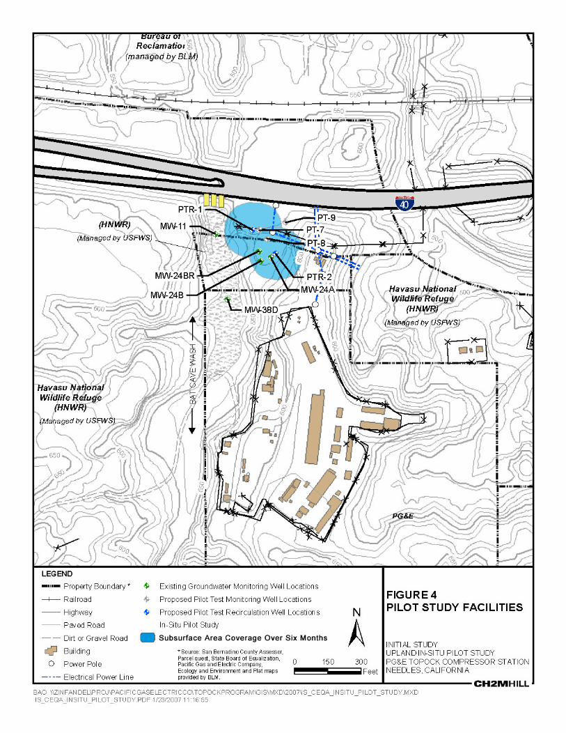

5
5
5
55
5
5
5
55
5
5
5
5
5
55
5
5
5
5
5
5
5
5
5
5
5
5
5
5
5
5
5
5
5
5
5
5
5
5 5
5
5
55
5
5 5
55
5
555
5
55
5
55
55
55
5
55
55 5
555
5
5
5
5
5
5
55
5
5
55
5
5
5
5
5
5
5
5
5
5
5
5
55
55
5
5
5
55
5
5
5
5
5
5
5
5
5
5
5
5
5
5
55 5
5
5
!A
!A
!A
!A
!A
!A!A
!A
!A
!A
!A
!A
!A
!(
!(
!(
!(
!(
!(
!A
#*
#*
#*
!A!A
PG&E
Interstate Hwy 40
MW-10
MW-24B
PGE-07
MW-24AMW-24BR
PGE-06MW-11
600 550
600
600
550
600
550
550
550
BAT C
AVE
WASH
TopockCompressor
Station
HNWR
PG&E
PROP
ERTY
HNWR
PG&E
PROP
ERTY NORTH GATE
CULVERTS
TW-1
PGE-08
MW-9
MW-38SMW-38D
PT-8PT-7
PT-9
50 0 50 100Feet ³
FIGURE 5LOCATION OF TEST WELLS PGE-7, PGE-8INITIAL STUDYUPLAND IN-SITU PILOT STUDYPG&E TOPOCK COMPRESSOR STATIONNEEDLES, CALIFORNIA
Scale: 1 inch = 100'
LEGEND#* Upland Pilot Study Well!A Hydraulic Test Well!A Existing Monitoring Well
BUILDINGS5 FENCE
PG&E BOUNDARY!( POWER POLE
ELECTRICAL POWER LINE
BAO \\ZINFANDEL\PROJ\PACIFICGASELECTRICCO\TOPOCKPROGRAM\GIS\MXD\2007\IS_CEQA_PGE_WELL_LOCATION.MXDIS_CEQA_PGE_WELL_LOCATION.PDF 1/23/2007 11:19:11
2101576.243758
MW-24 bench

5
5
5
55
5
5
5
5
5
5
55
55
5
5
5
5
5
5
5
5
5
5
5
5
5
5
5
55
5
5
5
5
5
55
5
5
5
5
5
5
5
5
5
5
5
5
5
5
5
5
55
5
55 5
55
55
5555
5 5
55
5
5
5555
5
555
5
55
5
55
55
5
55
55
5 55
5
5
5
5
5
5
5
5
55
5
5
55
5
5
5
5
5
5
5
5
5
5
5
5
5
5
5
5
5
55
55
55
5
5
5
5
55
55
55
5
5
5
5
5
5
5
5
5
5
5
5
5
5
5
5
5
55 5 5
5
5
5
5
!A
!A
!A
!A
!A
!A!A
!A
!A
!A
!A
!A
!A
!(
!(
!(
!(
!(
!(
Interstate Hwy 40
MW-10
MW-24BMW-24A
MW-24BR
PGE-07
MW-11
600
600
600
550
600
550
550
550
BAT CAVE WASH
TopockCompressor
Station
HNWR
PG&E
PROP
ERTY
HNWR
PG&E
PROP
ERTY NORTH GATE
TW-1
PGE-6 Work Area
Access Route
Staging Area
Field Trailer
Potential Staging Area
MW-24 bench
50 0 50 100Feet
³ FIGURE 6LOCATION OF PGE-6 AND PROPOSEDACCESS AND STAGING AREASINITIAL STUDYUPLAND IN-SITU PILOT STUDYPG&E TOPOCK COMPRESSOR STATIONNEEDLES, CALIFORNIAScale: 1 inch = 100'
LEGENDBUILDINGSGRAVEL ROAD / AREAPAVED ROAD
5 FENCEPG&E BOUNDARY
!( POWER POLEELECTRICAL POWER LINE
BAO \\ZINFANDEL\PROJ\PACIFICGASELECTRICCO\TOPOCKPROGRAM\GIS\MXD\2007\IS_CEQA_PGE_06_SITEPLAN.MXD IS_CEQA_PGE_06_SITEPLAN.PDF 1/23/2007 11:21:30