petroleum resource development - nr.gov.nl.ca · this marked another milestone for the province as...
TRANSCRIPT
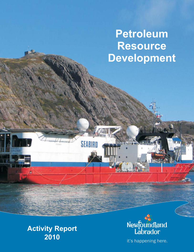
it’s happening here.
Activity Report
2010
PetroleumResource
Development

February, 2011 Petroleum Resource Development - Activity Report 2010
Department of Natural ResourcesPetroleum Resource Development
Activity Report - 2010
Table of Contents
1.0 Introduction ............................................................................ 1
2.0 Field Development Summary
2.1 Hibernia - Main Field .................................................. 7 2.1.1 Hibernia Southern Extension - AA Block .................... 10 2.1.2 Hibernia Southern Extension - Hibernia South Extension (HSE) Unit ........................ 12 2.2 Terra Nova Field ........................................................ 14 2.3 White Rose Field ....................................................... 16 2.3.1 West White Rose Extension ...................................... 19 2.3.2 South White Rose Extension ..................................... 19 2.4 North Amethyst Field ................................................. 20 2.5 Hebron/Ben Nevis Field ............................................. 22 2.6 Garden Hill South Field .............................................. 24 3.0 Regional Activity Update
3.1 East Coast Offshore - North Grand Banks.................. 26 3.2 South Coast Offshore ................................................. 30 3.3 West Coast Onshore and Offshore ............................ 32 3.4 Labrador Offshore....................................................... 35
Appendix A - Newfoundland and Labrador Land Rights Map
Appendix B - Jeanne d’Arc Basin Land Rights Map


February, 2011 Petroleum Resource Development - Activity Report 2010 1
1.0 Introduction
Newfoundland and Labrador, Canada’s most easterly province, has been an active oil pro-ducing region for the past 13 years. The province’s four oil projects; Hibernia, Terra Nova, White Rose and North Amethyst produced in excess of 100 million barrels of oil in 2010. This level of production accounted for approximately one third of Canada’s conventional light crude output. Exploration and development continued both offshore and onshore in 2010 and this report highlights the petroleum development activity within the province’s many sedimentary basins.
The graph below shows that world oil prices have ranged from the mid $60 to almost $90 per barrel in 2010. The value of the province’s oil production was in excess of $8.0 billion CAD in 2010 and was a signifi cant contributor (approximately 30%) to the province’s gross domestic product (GDP). Further, the industry accounts for almost 2.5% of provincial em-ployment.
Figure #1 - Cushing, OK, WTI Spot Price FOB, per barrel - 2010
$0
$10
$20
$30
$40
$50
$60
$70
$80
$90
$100
Jan Feb Mar Apr May Jun Jul Aug Sep Oct Nov Dec
Month
$USD

2 Petroleum Resource Development - Activity Report 2010 February, 2011
Figure #2 - Sedimentary Basins of Newfoundland and Labrador

February, 2011 Petroleum Resource Development - Activity Report 2010 3
As of December 31, 2010 Newfoundland and Labrador had discovered reserves of 3.1 bil-lion barrels of oil and 11 trillion cubic feet of natural gas. Geoscience data indicates that a further 6 billion barrels of oil and 60 trillion cubic feet of natural gas remain undiscovered. Cumulative oil production totalled 1.2 billion barrels of oil as of December 31, 2010.
The province’s newest producing fi eld, North Amethyst, produced fi rst oil on May 31, 2010. This marked another milestone for the province as it represented production from Canada’s fi rst offshore satellite tieback project. Development activity proceeded within existing fi elds in 2010 including the southern portion of the Hibernia fi eld as well as the western portion of the White Rose fi eld.
Work also continued in 2010 to advance the Hebron development. It is expected to be the province’s fi fth producing fi eld and it is forecasted to commence production in 2017. Major contracts have been awarded by the operator for front end engineering and design on the topsides portion and also for the gravity based structure.
Currently Newfoundland and Labrador has less than 10% of prospective onshore and off-shore land held under license by various operators. The total potential acreage, as outlined on the Sedimentary Basins Map on page 2, is in excess of 80 million hectares offshore and 1.5 million hectares onshore. As the map illustrates the numerous offshore sedimentary basins are located throughout Newfoundland and Labrador whereas the onshore potential is focused around the western portion of the island of Newfoundland only.
Petroleum activity in Newfoundland and Labrador is regulated by two distinct authorities. For offshore activity, the Canada-Newfoundland and Labrador Offshore Petroleum Board (C-NLOPB) is responsible, on behalf of the Federal Government of Canada and the Provin-cial Government of Newfoundland and Labrador, for petroleum resource management. With respect to the onshore, the Provincial Government of Newfoundland and Labrador has sole management authority.
The C-NLOPB issues land rights in three different classes; exploration licenses, signifi cant discovery licenses and production licenses. As of December 31, 2010 the C-NLOPB had 33 exploration licenses, 49 signifi cant discovery licenses and 8 production licenses on record. During 2010 successful work expenditure bids totaling $111,494,000 were received on Calls for Bids conducted in the Jeanne d’Arc and Flemish Pass basins. Exploration licenses will

4 Petroleum Resource Development - Activity Report 2010 February, 2011
Table #1 - Petroleum Reserves1 and Resources2 Newfoundland Offshore Area Field Oil Gas NGLs3 106 m3 million bbls 109 m3 billion cu. ft. 106 m3 million bbls Grand Banks Hibernia 221.9 1395 55.9 1984 35.8 225
Terra Nova 66.6 419 1.5 53 0.6 4
Hebron 92.4 581 - - - -
Whiterose 48.4 305 85.3 3023 15.3 96
Ben Nevis 18.1 114 12.1 429 4.7 30
West Bonne Bay 5.7 36 - - - -
North Amethyst 10.8 68 8.9 315
West Ben Nevis 5.7 36 - - - -
Mara 3.6 23 - - - -
North Ben Nevis 2.9 18 3.3 116 0.7 4
Springdale 2.2 14 6.7 238 - -
Nautilus 2.1 13 - - - -
King’s Cove 1.6 10 - - - -
South Tempest 1.3 8 - - - -
East Rankin 1.1 7 - - - -
Fortune 0.9 6 - - - -
South Mara 0.6 4 4.1 144 1.2 8
North Dana - - 13.3 472 1.8 11
Trave - - 0.8 30 0.2 1
Sub-Total 485.9 3056 191.9 6804 60.3 379
Labrador Shelf North Bjarni - - 63.3 2247 13.1 82
Gudrid - - 26.0 924 1.0 6
Bjarni - - 24.3 863 5.0 31
Hopedale - - 3.0 105 0.4 2
Snorri - - 3.0 105 0.4 2
Sub-Total 0.0 0 119.6 4244 19.9 123
Total 485.9 3056 311.5 11048 80.2 502
Produced4 189.3 1191 0.0 0 0.0 0
Remaining 296.6 1866 311.5 11048 80.2 502
1 “Reserves” are volumes of hydrocarbons proven by drilling, testing and interpretation of geological, geophysical and engineering data, that are considered to be recoverable using current technology and under present and anticipated economic conditions. Oil reported for Hibernia, Terra Nova, White Rose and North Amethyst fi elds are classifi ed as reserves. 2 “Resources” are volumes of hydrocarbons, expressed at 50% probability, assessed to be technically recoverable that have not been delineated and have unknown economic viability. Gas, NGLs3, and oil in undeveloped fi elds are currently classifi ed as resourc-es. 3 “Natural Gas Liquids””(NGLs) are derived from natural gas, which is the portion of petroleum that exists in either the gaseous phase or in solution in crude oil in natural underground reservoirs. 4 Produced volumes as of December 31, 2010. Produced oil reserves also include a small quantity of natural gas liquids. * NGL estimates have not been updated since 2006.

February, 2011 Petroleum Resource Development - Activity Report 2010 5
be issued on these land parcels early in 2011 when all relevant terms and conditions are met.
With respect to the onshore area, the Government of Newfoundland and Labrador issues land rights in two categories; exploration permits and production leases. Note that there were no changes in the number of permits or leases in 2010. As of December 31, 2010 the province had 9 exploration permits and one production lease on record. The exploration licenses onshore, encompassing approximately 288,500 hectares, are issued in three gen-eral areas in western Newfoundland; Flat Bay, Deer Lake and Parsons Pond. The produc-tion lease is issued to PDI Production Inc. at the Garden Hill site located on the Port au Port Peninsula. The regional activity section in Section 3.0 of this report details the relevant activity at each location.
The high level of exploration drilling onshore western Newfoundland continued in 2010. Following two exploration wells completed by Vulcan Minerals in 2009, Nalcor Energy com-pleted two exploration wells and Deer Lake Oil and Gas drilled one exploration well on their various licenses. Several of the wells encountered gas bearing zones and further analysis and completion programs are expected to be conducted in 2011.
In 2010 the Province of Newfoundland and Labrador completed a Call for Posting, which is the preliminary step in announcing a Request for Bids for an onshore land licensing round. Approximately 28,000 square kilometres of land was open for nomination and the Call for Postings closed on December 15, 2010.
The local partners in the rig sharing agreement for the semi-submersible drilling rig, Henry Goodrich, reached an agreement in 2010 to extend the contract for the rig for an additional 3 year period. As mentioned previously, the 2010 offshore Calls for Bids generated an ad-ditional $111,494,000 CAD in new offshore work expenditure commitments. This raised the total outstanding offshore work expenditure commitment to close to $1 billion CAD at the end of 2010 which bodes well for future exploration and development.
Three major 2D seismic programs were conducted in the Newfoundland and Labrador region in 2010. Husky Energy completed a program offshore Labrador covering 5,550 line kilometers as well as a 3006 line kilometer offshore program in the Sydney basin. Lastly Vulcan Minerals completed a 130 line kilometer onshore 2D survey in Flat Bay. This survey

6 Petroleum Resource Development - Activity Report 2010 February, 2011
is one of the largest onshore seismic surveys ever completed in Newfoundland.
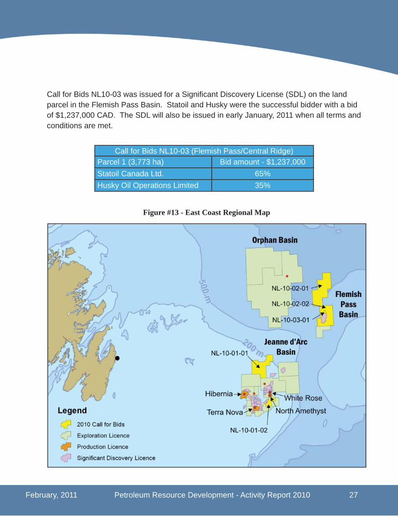
As of December 31, 2010 a total of 362 wells have been spudded in Newfoundland and Labrador’s offshore waters. A total of 49 signifi cant discovery licenses have been issued by the C-NLOPB in 25 areas including 5 on the Labrador Shelf, 19 in the Jeanne d’Arc Basin and one in the Flemish Pass Basin. While the C-NLOPB has issued a signifi cant discov-ery license to Statoil for their Mizzen discovery in the Flemish Pass Basin they have not released a resource estimate on the size of the discovery. An estimate of the size is not expected to be released until the full extent of the Mizzen discovery is determined.
The tragedy and environmental damage with the Deepwater Horizon incident in the Gulf of Mexico in April, 2010 had an affect on petroleum exploration on a worldwide basis. New-foundland and Labrador was not immune. Subsequent to the Macondo blowout, the C-NLOPB implemented extra oversight measures on exploration wells staring with the Chev-ron et al. Lona 0-55 well which was spud on May 10, 2010. The exploration well was drilled in the Orphan Basin in approximately 2600 metres without incident.
Offshore petroleum exploration activity is expected to be maintained at a high level in 2011. Suncor has announced that they will be returning to their Ballicatters prospect in Jeanne d’Arc Basin to drill a sidetrack exploration well. Further, Statoil have announced plans for a delineation well at their Mizzen prospect in the Flemish Pass Basin as well as an exploration well in the Jeanne d’Arc Basin at their Fiddlehead prospect. This exploration activity com-bined with development work continuing on the Hibernia, White Rose and Hebron projects demonstrates industry’s continued confi dence in the petroleum industry in Newfoundland and Labrador.

February, 2011 Petroleum Resource Development - Activity Report 2010 7
2.0 Field Development Summary
2.1 Hibernia - Main Field
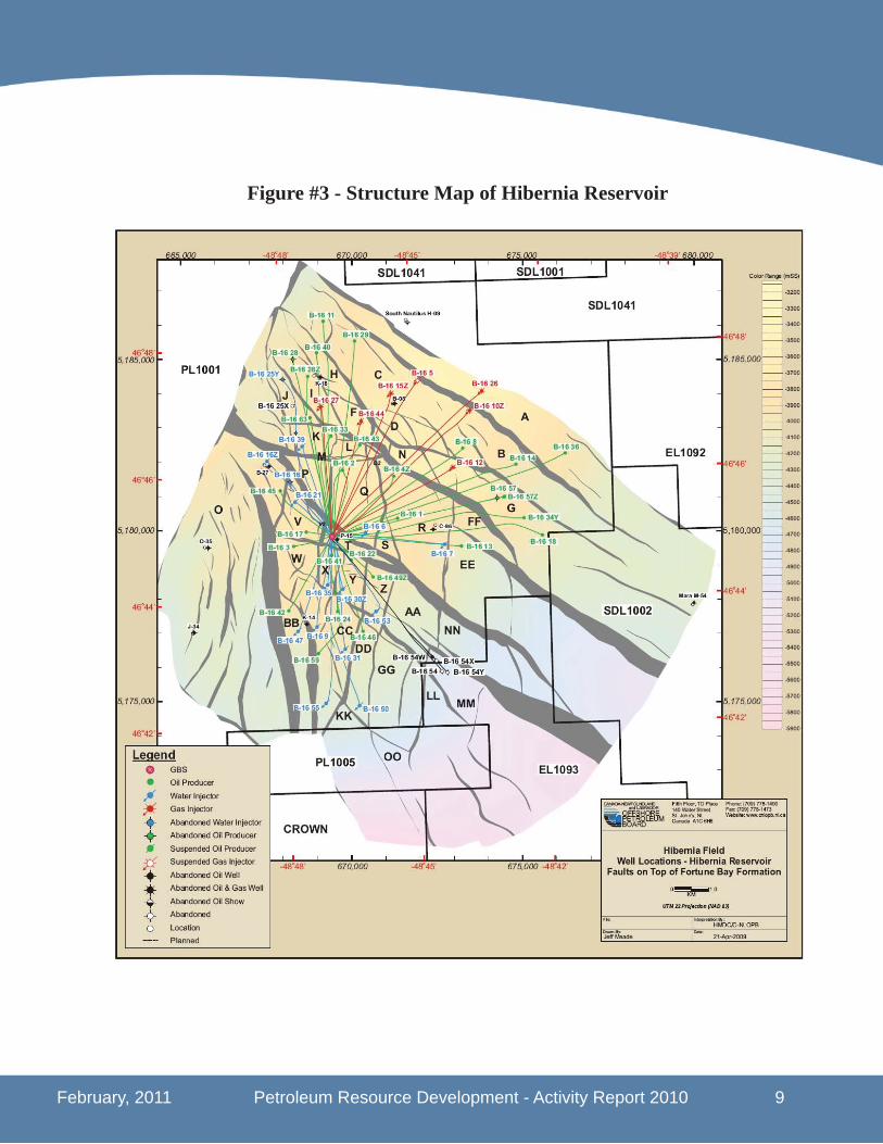
The Hibernia fi eld, the fi rst fi eld de-velopment in the Newfoundland and Labrador offshore region, remains the province’s largest offshore oil project in terms of recoverable reserves. The fi eld was discovered in 1979 by Chevron et al with the drilling of the Hibernia P-15 well. The well was drilled approximately 315 kilometers east southeast of St. John’s, NL in about 80 meters of water. A fi xed production platform consisting of a gravity-based structure (GBS) and topsides drilling and production facilities are being utilized to produce the fi eld. The platform is 224 meters tall, weighs 1.2 million tonnes and can store 1.3 million barrels of oil. Shipments of oil from Hibernia are offl oaded at the purpose built transshipment facility at Whiffen Head, Placentia Bay, NL.
Production from the Hibernia fi eld to date has been from two main reservoirs; Hiber-nia and Ben Nevis/Avalon. Hibernia fi eld development was based on an original re-serve estimate of 520 million barrels of oil at an average annual oil production rate (APR) of 110,000 barrels of oil per day (bopd). There have been several increases to the oil reserve estimate and in 2010 the Can-ada-Newfoundland and Labrador Offshore Petroleum Board (C-NLOPB) increased the recoverable reserves estimated for the Hibernia fi eld to 1.395 billion barrels of oil, 1.864 trillion cubic feet natural gas and 225 million barrels of natural gas liquids. The current approved annual production rate for the Hibernia platform is 220,000 barrels of oil per day.
Hibernia Project - Ownership (Main Field)ExxonMobil 33.125%Chevron 26.875%Suncor 20%Canadian Hibernia Holding Corp. 8.50%Murphy Oil 6.50%Statoil ASA 5%
Hibernia GBS

8 Petroleum Resource Development - Activity Report 2010 February, 2011
During 2010 two wells were completed bringing the total number of development wells be-ing utilized at the main Hibernia fi eld to 64. They include 35 oil producers, 23 water injec-tors and 6 gas injectors. Hibernia produced 56.3 million barrels of oil during 2010 giving an average daily production of 154,348 bopd. Cumulative oil production to December 31, 2010 was 722.9 million barrels representing 51.8% of the total current reserve estimate.
In concert with the production of oil, the Hibernia platform also produces and handles natu-ral gas. Since gas injection began in 2000, approximately 90% of the gas produced has been re-injected into the reservoir for pressure maintenance and to optimize oil recovery. The balance of the gas that is produced is mainly used as the primary fuel source for the platform.
Oil production in 2010 was higher than originally expected and was the result of production commencing from Hibernia’s AA Block as discussed in section 2.1.1 of this report. In June 2009 it was announced that the Hibernia project had reached payout; the time at which all development costs have been recovered. As a result of this milestone, the Province of Newfoundland and Labrador is now receiving a royalty rate of 30% for oil extracted from the main part of the Hibernia fi eld.
Additional drilling around the original Hibernia discovery in 2005 and 2006 confi rmed sig-nifi cant upside reserves in the southern portion of the Hibernia fi eld. Since that time the partners have been working on plans to develop this area and have divided the Hibernia Southern Extension into two parts; the Hibernia AA Block and the Hibernia South Extension (HSE) Unit. Figure 4 located on page 11 shows the two sections within the Hibernia South-ern Extension.
A Memorandum of Understanding to develop the southern portion of the fi eld was signed with the Province on June 16, 2009. Subsequent to this agreement the C-NLOPB approved amendments to the Hibernia Development Plan on August 18, 2009 and September 2, 2010 to accommodate the development of the AA Block and the HSE Unit respectively. Details on each of these projects are outlined in sections 2.1.1 and 2.1.2 of this report. Oil production from both the AA Block and HSE Unit will partially offset the natural production decline at the main Hibernia fi eld and extend the life of fi eld development for the Hibernia platform. It is now expected that the Hibernia platform will continue to produce oil until 2040. Once natural gas is produced on a commercial basis this timeframe could be extended further.
February, 2011 Petroleum Resource Development - Activity Report 2010 9
Figure #3 - Structure Map of Hibernia Reservoir
10 Petroleum Resource Development - Activity Report 2010 February, 2011
2.1.1 Hibernia Southern Extension - AA Block
Figure 4 on page 11 shows the location of the Hibernia AA Block (includes AA1 and AA2) within the main Hibernia Production License PL-1001 and contained in the Hibernia reser-voir. Work commenced on the block in late 2009 after the development plan amendment was approved by the C-NLOPB on August 18, 2009. The program for the AA Block included drilling four development wells directly from the Hibernia platform. The four well drilling program which was completed in 2010 consisted of two pairs of oil producers (B16-57X and B16-5Z) and water injectors (B16-37Z and B16-54V).
The C-NLOPB has assigned a recoverable reserve estimate of 48 million barrels of oil for the AA Block. Note that these reserves are included in the overall Hibernia recoverable reserve estimate of 1.395 billion barrels of oil mentioned previously in Section 2.1 - Hibernia - Main Field. Production from the AA Block is estimated to average 11,000 bopd with peak production reaching 25,000 bopd. The estimated costs for drilling and tie-in activities of the AA Block development was $196 million CAD and production is expected to last until 2024.
Production from the fi rst oil producer (B-16-57X) occurred on November 27, 2009 and the second oil producer (B-16-5Z) was brought on line on July 28, 2010. In 2010, 8.1 million barrels of oil were produced from the AA Block giving an average daily production of 22,075 barrels of oil. The total cumulative production to December 31, 2010 was 8.3 million barrels of oil.
As part of the Hibernia Southern Extension Agreement signed with the province on February 16, 2010 an equity ownership of 10% was negotiated for Nalcor Energy - Oil and Gas, the province’s wholly owned energy corporation. The purchase price of the ownership posi-tion was $30 million CAD and applies to any new development within the Hibernia Southern Extension exclusive of the AA Block. In addition Nalcor Energy has agreed to cover 10% of future development costs and in return will receive 10% of oil production. The ownership structure for the AA Block therefore remains the same as the original Hibernia Main Field as detailed on page 7.
However, the new agreement with the Provincial Government included an enhanced royalty rate of 42.5% from oil produced from the existing GBS within Hibernia Southern Extension. This new rate would therefore apply to production from the AA Block. The rate will increase
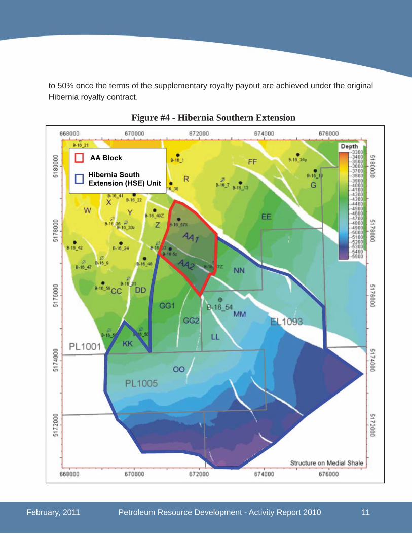
February, 2011 Petroleum Resource Development - Activity Report 2010 11
to 50% once the terms of the supplementary royalty payout are achieved under the original Hibernia royalty contract.
Figure #4 - Hibernia Southern Extension

12 Petroleum Resource Development - Activity Report 2010 February, 2011
2.1.2 Hibernia Southern Extension - Hibernia South Extension (HSE) Unit
As part of the development plan amendment approved by the C-NLOPB on September 2, 2010 the interest holders in Production Licenses 1001 and 1005, and Exploration License 1093 were granted the right to develop the Hibernia reservoir located in the Hibernia South Extension (HSE) Unit as show in Figure 4 on page 11. The additional area included in the amendment include the GG, KK, LL, MM, NN and possibly the OO fault blocks.
The C-NLOPB has estimated recoverable reserves in the HSE Unit at 167 million barrels of oil. Note that this fi gure is included in the 1.395 billion barrels of oil total resource esti-mate for the Hibernia fi eld. Development of the HSE Unit will include a combination of wells drilled from the Hibernia platform as well as from a subsea drilling program utilizing a mobile offshore drilling unit. The total cost of the HSE development is estimated at $1.735 billion CAD with the subsea and platform drilling expected to account for in excess of $1.1 billion CAD of the total.
The approved development plan for the HSE Unit includes the drilling of 10 wells compris-ing 5 pairs of production and water injectors. The production wells will be drilled from the Hibernia platform from existing GBS slots. Drilling of these wells is scheduled to commence early in 2013 and continue for approximately 2 years. This drilling schedule may commence earlier depending on drilling performance on the platform. The subsea drilling program is scheduled for 2013 to 2015 when a semi-submersible offshore drilling unit is mobilized to the area. An excavated drill centre to accommodate the subsea templates and manifolds for the water injection wells will be located approximately 7 kilometers southeast of the Hibernia GBS. The fl owlines and umbilicals will be connected to the Hibernia platform utilizing two existing J-tubes installed in the platform at the time of original construction.
As mentioned in Section 2.1, with the signing of the Hibernia South Development Agree-ment on February 16, 2010 with the Provincial Government, new fi scal measures were included encompassing production from the southern portion of the Hibernia Field. These new fi scal measures included a 10% ownership position for Nalcor Energy - Oil and Gas, exclusive of the AA Block development, and an enhanced royalty structure for all production covered within the Hibernia South Extension area. Note that fi rst oil from the HSE Unit is not expected until late in 2013.

February, 2011 Petroleum Resource Development - Activity Report 2010 13
The new royalty framework is divided between production from land licensed under the original Production License (PL1001) and land licensed under both the Production License (PL-1005) and the Exploration Licenses (EL-1093).
With respect to production from the HSE Unit from within the original PL-1001, the new royalty framework will consist of the current basic royalty rate of 30%. This rate will increase to 37.5% when the price of West Texas Intermediate (WTI) crude oil exceeds $50 USD per barrel and increases to 42.5% when the price of WTI crude exceeds $70 USD per barrel. A top royalty rate of 50% will be applicable when the project meets the terms of the supple-mentary royalty payout under the terms of the original Hibernia royalty contract.
The new royalty structure for oil production from lands licensed under PL-1005 and EL-1093 calls for a basic 5% royalty rate from fi rst oil. This rate increases to a Tier 1 rate of 30% when payout occurs on the project. This rate rises to 32.5% when WTI crude pricing ex-ceeds $50 USD per barrel and then increases further to 37.5% when WTI pricing exceeds $70 USD per barrel. A top royalty rate of 50% will be applicable when the project meets the terms of the supplementary royalty payout under the terms of the original Hibernia royalty contract.
The new ownership structure in PL-1005 and El-1093 refl ecting Nalcor’s new position are shown in the following graphs.
The Hibernia Southern Extension agreement also includes commitments that the propo-nents will comply with the C-NLOPB requirements on research, development, education and training. Further the proponents agreed to spend $10 million within three years of fi rst oil commercial production on one or more legacy projects and also includes a gender equity and diversity program for all phases of the project.
PL 1005 Ownership Suncor 22.5%ExxonMobil 22.5%Statoil ASA 22.5%Chevron 22.5%Nalcor Energy 10%
EL 1093 OwnershipExxonMobil 29.8125%Chevron 24.1875%Suncor 18%CHHC 7.65%Murphy 5.85%Statoil 4.5%Nalcor Energy 10%

14 Petroleum Resource Development - Activity Report 2010 February, 2011
2.2 Terra Nova Field
The Terra Nova fi eld was discovered by Petro-Canada (now Suncor Energy) in 1984 about 35 kilometers southeast of Hibernia, in about 90 meters of water. The discovery well, Terra Nova K-08, located about 350 southeast of St. John’s, NL fl ow-tested 10,000 barrels of oil per day from the Jeanne d’Arc reservoir. Five subsequent suc-cessful delineation wells tested at rates ranging from 5,000 to 25,000 bopd.
The fi eld is being developed using a Floating Production Storage and Offl oading (FPSO) vessel and fi rst oil was produced on January 20, 2002. The Terra Nova FPSO was the fi rst of its kind to be used in North America and included the largest disconnectable turret moor-ing system in the world. The vessel is double hulled with oil cargo tanks capable of holding up to 960,000 barrels of oil.
The latest recoverable reserve estimate for the Terra Nova fi eld, released in 2009, includes 419 million barrels of oil, 53 billion cubic feet of natural gas and 4 million bar-rels of natural gas liquids. The approved production rate for the Terra Nova FPSO is 180,000 barrels of oil per day.
As of December 31, 2010 Terra Nova had a total of 27 development wells completed. This consisted of 15 oil producers, 9 water injectors and 3 gas injectors. During 2010 the fi eld produced 24.9 million barrels of oil equating to a daily production of 68,325 bopd. Cumulative fi eld production to the end of 2010 was 311.4 million barrels of oil which represents 74.3% of the recoverable reserve estimate.
Terra Nova Project - OwnershipSuncor 33.99%ExxonMobil 22%Husky Oil 12.51%Statoil ASA 15%Murphy 12%Mosbacher 3.50%Chevron 1%
Terra Nova FPSO
February, 2011 Petroleum Resource Development - Activity Report 2010 15
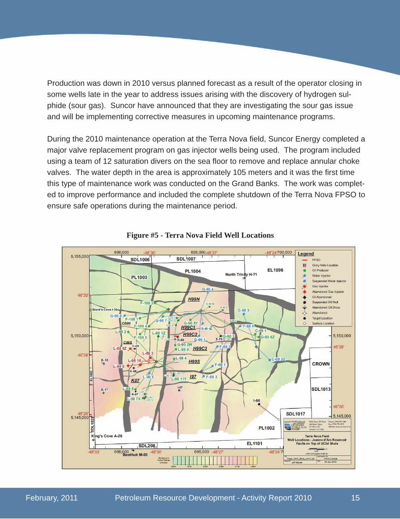
Production was down in 2010 versus planned forecast as a result of the operator closing in some wells late in the year to address issues arising with the discovery of hydrogen sul-phide (sour gas). Suncor have announced that they are investigating the sour gas issue and will be implementing corrective measures in upcoming maintenance programs.
During the 2010 maintenance operation at the Terra Nova fi eld, Suncor Energy completed a major valve replacement program on gas injector wells being used. The program included using a team of 12 saturation divers on the sea fl oor to remove and replace annular choke valves. The water depth in the area is approximately 105 meters and it was the fi rst time this type of maintenance work was conducted on the Grand Banks. The work was complet-ed to improve performance and included the complete shutdown of the Terra Nova FPSO to ensure safe operations during the maintenance period.
Figure #5 - Terra Nova Field Well Locations
16 Petroleum Resource Development - Activity Report 2010 February, 2011
2.3 White Rose Field
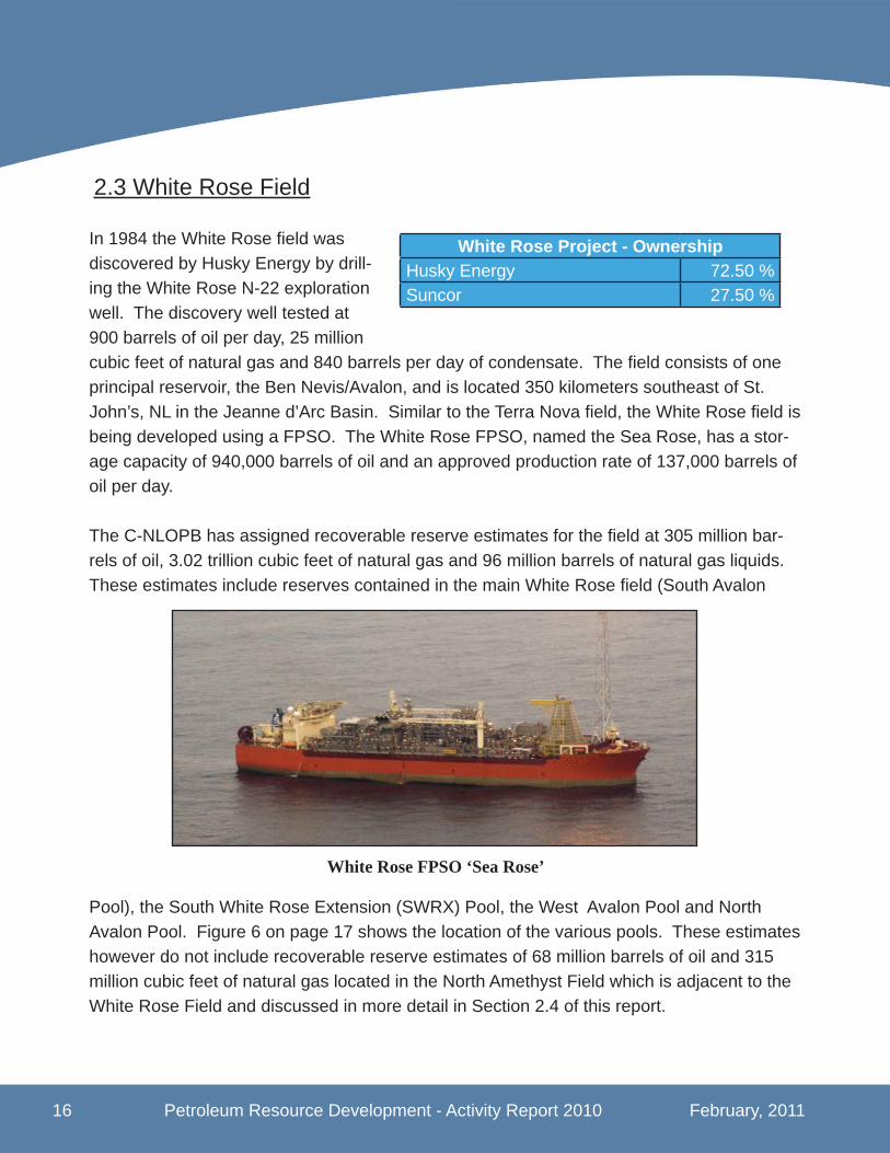
In 1984 the White Rose fi eld was discovered by Husky Energy by drill-ing the White Rose N-22 exploration well. The discovery well tested at 900 barrels of oil per day, 25 million cubic feet of natural gas and 840 barrels per day of condensate. The fi eld consists of one principal reservoir, the Ben Nevis/Avalon, and is located 350 kilometers southeast of St. John’s, NL in the Jeanne d’Arc Basin. Similar to the Terra Nova fi eld, the White Rose fi eld is being developed using a FPSO. The White Rose FPSO, named the Sea Rose, has a stor-age capacity of 940,000 barrels of oil and an approved production rate of 137,000 barrels of oil per day.
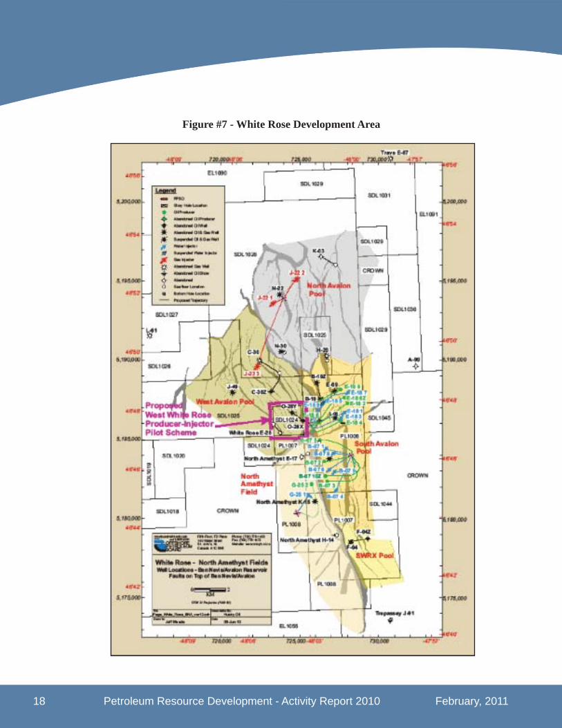
The C-NLOPB has assigned recoverable reserve estimates for the fi eld at 305 million bar-rels of oil, 3.02 trillion cubic feet of natural gas and 96 million barrels of natural gas liquids. These estimates include reserves contained in the main White Rose fi eld (South Avalon
Pool), the South White Rose Extension (SWRX) Pool, the West Avalon Pool and North Avalon Pool. Figure 6 on page 17 shows the location of the various pools. These estimates however do not include recoverable reserve estimates of 68 million barrels of oil and 315 million cubic feet of natural gas located in the North Amethyst Field which is adjacent to the White Rose Field and discussed in more detail in Section 2.4 of this report.
White Rose Project - OwnershipHusky Energy 72.50 %Suncor 27.50 %
White Rose FPSO ‘Sea Rose’

February, 2011 Petroleum Resource Development - Activity Report 2010 17
In 2010 the C-NLOPB approved a development plan amendment for the White Rose fi eld to allow development of the West White Rose area. This amendment proposed a two well pilot scheme in the West Avalon Pool to further assess the viability and feasibility of a full fi eld development in this area. See Section 2.3.1 on Page 19 for more details on this devel-opment.
First oil was produced at the White Rose fi eld on November 15, 2005 with total cumulative production of 152.8 million barrels of oil as of December 31, 2010. In 2010 production at the White Rose fi eld totalled 15.7 million barrels of oil which equated to an average daily production of 45,925 barrels of oil per day. The fi eld is being developed utilizing 21 develop-ment wells consisting of 8 production, 10 water injectors and 3 gas injectors.
Figure #6 - White Rose Development Area
18 Petroleum Resource Development - Activity Report 2010 February, 2011
Figure #7 - White Rose Development Area
February, 2011 Petroleum Resource Development - Activity Report 2010 19
2.3.1 West White Rose
Development of the West White Rose portion of the fi eld has been under analysis since 2001. This portion of the fi eld is part of the main Ben Nevis/Avalon reservoir and contained within Signifi cant Discovery License (SDL) 1047. Deliniation drilling in the region included the drilling of the J-49, O-28Y, O-28X, C-30, C-30Z, E-28 and J-22 3 wells. However, even with this level of drilling the co-venturers believe there is still uncertainty with the geological modelling of the area.
In 2010 a development plan amendment was submitted and approved by the C-NLOPB allowing for the drilling of a two well pilot scheme at West White Rose to further assess the viability and feasibility of fi eld development. The fi rst development well (E-18 10) was spud on April 23, 2010 by the drilling rig, Henry Goodrich, and is scheduled to begin producing in 2011. The second well if it is deemed necessary will be a water injector and is scheduled for completed in 2011. The initial estimated cost for the West White Rose pilot scheme was $250 million CAD which includes a $130 million CAD drilling program and $120 million CAD for subsea infrastructure.
The C-NLOPB have assigned a resource estimate for the West White Rose pool at 40 mil-lion barrels of oil. This amount is included in the total reserve estimate for the White Rose Field, as detailed in Section 2.3, however this fi gure could be revised once the results of the pilot scheme are known.
2.3.2 South White Rose Extension
A development plan amendment was approved by the C-NLOPB in 2007 for the South White Rose Extension (SWRX) contained within Signifi cant Discovery Licenses 1043 and 1044. The plan called for a subsea tie-back to the SeaRose FPSO through the existing southern glory hole as well as a new glory hole to be constructed approximately 4 kilome-ters further south. Although approval was granted by the C-NLOPB the co-venture partners have not yet proceeded with the development.
The C-NLOPB have assigned a resource estimate for the South White Rose Extension of 23 million barrels of oil which is also included in the total reserve estimate for White Rose as detailed in Section 2.3.

20 Petroleum Resource Development - Activity Report 2010 February, 2011
2.4 North Amethyst Field
In 2008 the co-venture partners; Husky Energy and Petro-Canada (now Suncor Energy), and the prov-ince, through Nalcor Energy Oil and Gas , signed a development agreement for lands surrounding the original White Rose Development. As part of this agreement, Nalcor agreed to purchase a 5% equity stake in the new project at a cost of $30 million CAD, subject to a confi rmation of reserve estimates. Note that the terms of the original White Rose development remain unchanged.
The North Amethyst fi eld is the fi rst of the satellite pools to be developed in the Jeanne d’Arc Basin. It was identifi ed by exploratory drilling in 2006 and the C-NLOPB reports re-coverable reserve estimates of 68 million barrels of oil and 315 billion cubic feet of natural gas in the Ben Nevis/Avalon Formation. In 2009 Husky Energy announced that additional
North Amethyst Project - OwnershipHusky Energy 68.875 %Suncor 26.125 %Nalcor Energy 5.0 %
Figure #8 - North Amethyst Tie Back Development via White Rose FPSO

February, 2011 Petroleum Resource Development - Activity Report 2010 21
resources were discovered at North Amethyst (Hibernia Formation), totalling approximately 60 million barrels of original oil in place. Further details on these new resources have not been released and the C-NLOPB have not yet completed an analysis of the new discovery for reserve estimates.
The initial estimated capital cost to develop North Amethyst was $1.5 billion CAD including $705 million CAD for drilling and completions and $587 million CAD for subsea develop-ment. Nine wells were planned for the development including four oil producers and fi ve water injectors. Completion and installation of the subsea components and modifi cations to the existing Sea Rose FPSO to allow for production from North Amethyst were completed in 2010. Flexible underwater fl owlines connect the fi eld to the SeaRose FPSO which is located approximately 6 kilometers away. Initial production from North Amethyst on May 31, 2010 was accomplished using two producers (G-25 2 and G-25 3) and one water injector (G-25 1). A second water injector (G-25 4) was completed in 2010. Cumulative produc-tion to December 31, 2010 was 3.8 million barrels of oil for an average daily production of 10,267 barrels.
Production from North Amethyst was an important milestone as it represents production from Canada’s fi rst offshore satellite tieback project. The additional production from North Amethyst will slow the decline in production at the SeaRose FPSO and extend its life of fi eld development.
Figure #9 - Jeanne d’Arc Basin
22 Petroleum Resource Development - Activity Report 2010 February, 2011
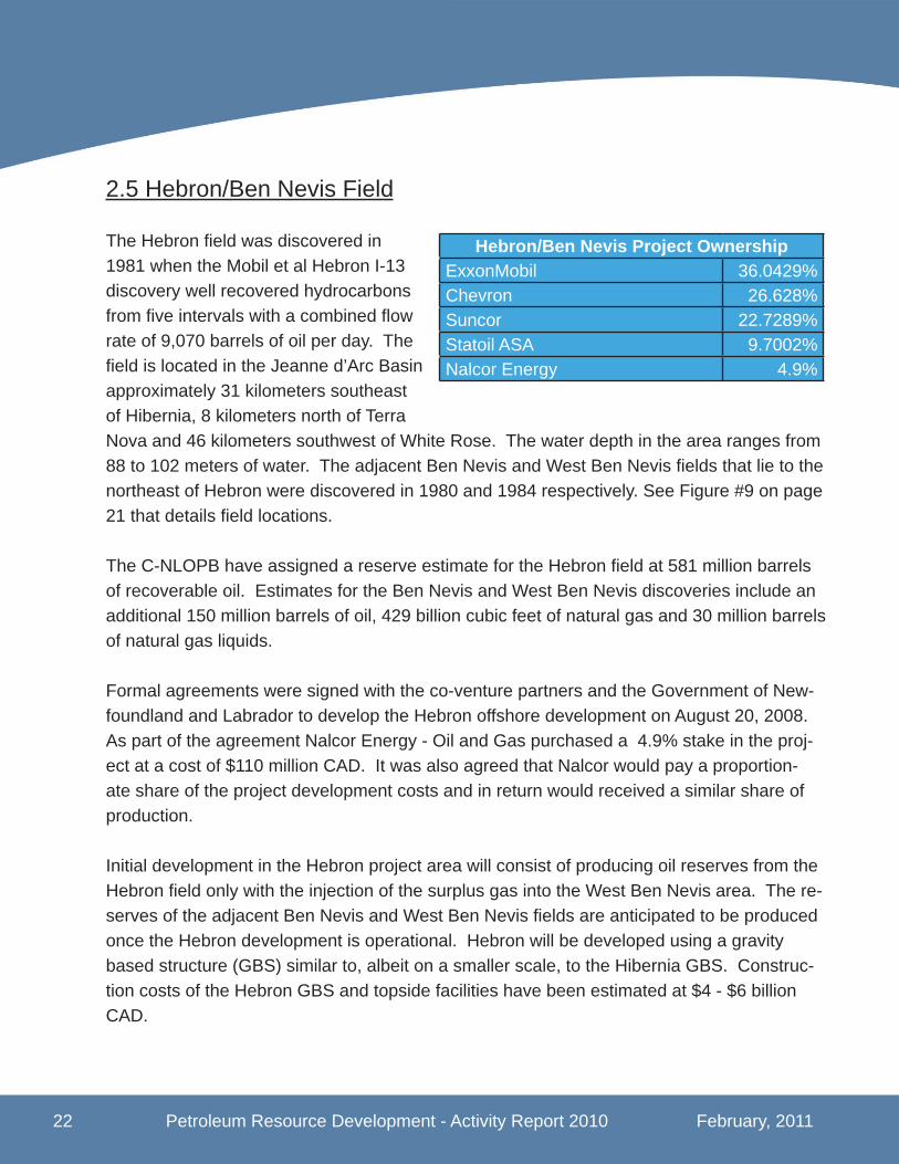
2.5 Hebron/Ben Nevis Field
The Hebron fi eld was discovered in 1981 when the Mobil et al Hebron I-13 discovery well recovered hydrocarbons from fi ve intervals with a combined fl ow rate of 9,070 barrels of oil per day. The fi eld is located in the Jeanne d’Arc Basin approximately 31 kilometers southeast of Hibernia, 8 kilometers north of Terra Nova and 46 kilometers southwest of White Rose. The water depth in the area ranges from 88 to 102 meters of water. The adjacent Ben Nevis and West Ben Nevis fi elds that lie to the northeast of Hebron were discovered in 1980 and 1984 respectively. See Figure #9 on page 21 that details fi eld locations.
The C-NLOPB have assigned a reserve estimate for the Hebron fi eld at 581 million barrels of recoverable oil. Estimates for the Ben Nevis and West Ben Nevis discoveries include an additional 150 million barrels of oil, 429 billion cubic feet of natural gas and 30 million barrels of natural gas liquids.
Formal agreements were signed with the co-venture partners and the Government of New-foundland and Labrador to develop the Hebron offshore development on August 20, 2008. As part of the agreement Nalcor Energy - Oil and Gas purchased a 4.9% stake in the proj-ect at a cost of $110 million CAD. It was also agreed that Nalcor would pay a proportion-ate share of the project development costs and in return would received a similar share of production.
Initial development in the Hebron project area will consist of producing oil reserves from the Hebron fi eld only with the injection of the surplus gas into the West Ben Nevis area. The re-serves of the adjacent Ben Nevis and West Ben Nevis fi elds are anticipated to be produced once the Hebron development is operational. Hebron will be developed using a gravity based structure (GBS) similar to, albeit on a smaller scale, to the Hibernia GBS. Construc-tion costs of the Hebron GBS and topside facilities have been estimated at $4 - $6 billion CAD.
Hebron/Ben Nevis Project OwnershipExxonMobil 36.0429%Chevron 26.628%Suncor 22.7289%Statoil ASA 9.7002%Nalcor Energy 4.9%

February, 2011 Petroleum Resource Development - Activity Report 2010 23
The Hebron development’s project offi ce was opened in St. John’s, NL in 2009. On Sep-tember 1, 2010 ExxonMobil, the project operator, awarded the Topsides Front End Engi-neering and Design (FEED) contract to WorleyParsons Canada Services Ltd. The contract also has an option, at ExxonMobil’s discretion, for WorleyParsons to provide subsequent Engineering, Procurement and Construction (EPC) services. WorleyParsons estimates the entire FEED/EPC contract to be worth US $85 million over fi ve years.
Also on November 9, 2010 ExxonMobil announced the awarding of the GBS FEED contract to Kiewit-Aker Contractors. Kiewit-Aker Contractors is a 50-50 joint venture between USA based Peter Kiewit Infrastructure and Norwegian based Aker Solutions. Peter Kiewit Infra-structure is affi liated with Peter Kiewit Sons’ Inc. which owns the Marystown Shipyard and the Cow Head fabrication yard located in the province. The FEED contract, valued at US $140 million, also includes site preparation at the Bull Arm fabrication site. Once again, at ExxonMobil’s discretion, the contract includes an option to extend the agreement to cover EPC services for the GBS. Construction of the GBS is expected to commence in 2012 at the Bull Arm site with fi rst oil expected in 2017.
Figure #10 - Propose Hebron GBS
24 Petroleum Resource Development - Activity Report 2010 February, 2011
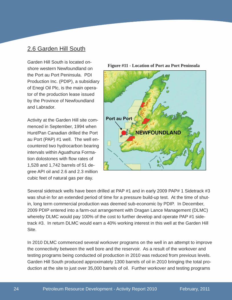
2.6 Garden Hill South
Garden Hill South is located on-shore western Newfoundland on the Port au Port Peninsula. PDI Production Inc. (PDIP), a subsidiary of Enegi Oil Plc, is the main opera-tor of the production lease issued by the Province of Newfoundland and Labrador.
Activity at the Garden Hill site com-menced in September, 1994 when Hunt/Pan Canadian drilled the Port au Port (PAP) #1 well. The well en-countered two hydrocarbon bearing intervals within Aguathuna Forma-tion dolostones with fl ow rates of 1,528 and 1,742 barrels of 51 de-gree API oil and 2.6 and 2.3 million cubic feet of natural gas per day.
Several sidetrack wells have been drilled at PAP #1 and in early 2009 PAP# 1 Sidetrack #3 was shut-in for an extended period of time for a pressure build-up test. At the time of shut-in, long term commercial production was deemed sub-economic by PDIP. In December, 2009 PDIP entered into a farm-out arrangement with Dragan Lance Management (DLMC) whereby DLMC would pay 100% of the cost to further develop and operate PAP #1 side-track #3. In return DLMC would earn a 40% working interest in this well at the Garden Hill Site.
In 2010 DLMC commenced several workover programs on the well in an attempt to improve the connectivity between the well bore and the reservoir. As a result of the workover and testing programs being conducted oil production in 2010 was reduced from previous levels. Garden Hill South produced approximately 1300 barrels of oil in 2010 bringing the total pro-duction at the site to just over 35,000 barrels of oil. Further workover and testing programs
Figure #11 - Location of Port au Port Peninsula
February, 2011 Petroleum Resource Development - Activity Report 2010 25
are planned in 2011 to improve productivity. It is hoped that these programs will sustain long term production in the range of 200 barrels of oil per day.
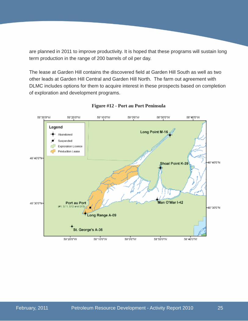
The lease at Garden Hill contains the discovered fi eld at Garden Hill South as well as two other leads at Garden Hill Central and Garden Hill North. The farm out agreement with DLMC includes options for them to acquire interest in these prospects based on completion of exploration and development programs.
Figure #12 - Port au Port Peninsula
26 Petroleum Resource Development - Activity Report 2010 February, 2011
3.0 Regional Activity Update
3.1 East Coast Offshore - North Grand Banks
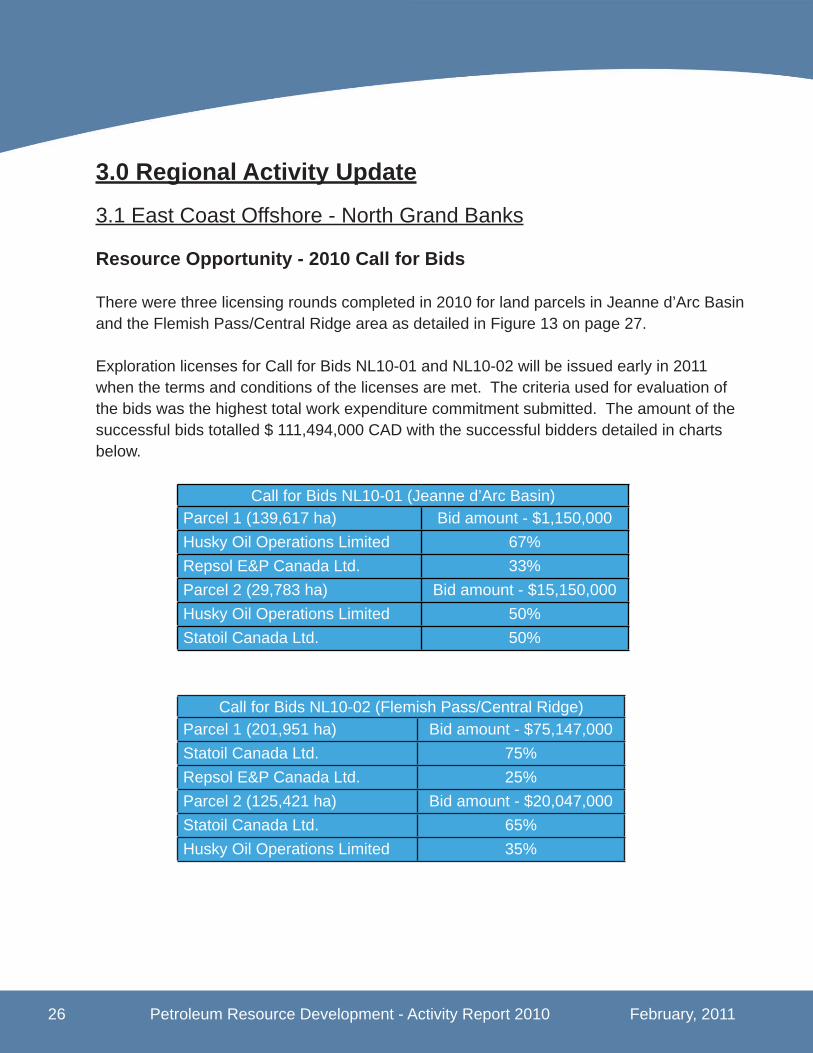
Resource Opportunity - 2010 Call for Bids
There were three licensing rounds completed in 2010 for land parcels in Jeanne d’Arc Basin and the Flemish Pass/Central Ridge area as detailed in Figure 13 on page 27.
Exploration licenses for Call for Bids NL10-01 and NL10-02 will be issued early in 2011 when the terms and conditions of the licenses are met. The criteria used for evaluation of the bids was the highest total work expenditure commitment submitted. The amount of the successful bids totalled $ 111,494,000 CAD with the successful bidders detailed in charts below.
Call for Bids NL10-01 (Jeanne d’Arc Basin)Parcel 1 (139,617 ha) Bid amount - $1,150,000Husky Oil Operations Limited 67% Repsol E&P Canada Ltd. 33% Parcel 2 (29,783 ha) Bid amount - $15,150,000Husky Oil Operations Limited 50% Statoil Canada Ltd. 50%
Call for Bids NL10-02 (Flemish Pass/Central Ridge)Parcel 1 (201,951 ha) Bid amount - $75,147,000Statoil Canada Ltd. 75% Repsol E&P Canada Ltd. 25% Parcel 2 (125,421 ha) Bid amount - $20,047,000Statoil Canada Ltd. 65% Husky Oil Operations Limited 35%
February, 2011 Petroleum Resource Development - Activity Report 2010 27
Call for Bids NL10-03 was issued for a Signifi cant Discovery License (SDL) on the land parcel in the Flemish Pass Basin. Statoil and Husky were the successful bidder with a bid of $1,237,000 CAD. The SDL will also be issued in early January, 2011 when all terms and conditions are met.
Call for Bids NL10-03 (Flemish Pass/Central Ridge)Parcel 1 (3,773 ha) Bid amount - $1,237,000Statoil Canada Ltd. 65% Husky Oil Operations Limited 35%
Figure #13 - East Coast Regional Map

28 Petroleum Resource Development - Activity Report 2010 February, 2011
Exploration Activity - Drilling ProgramsA total of three exploration wells were spud in the East Coast Offshore region in 2010. On January 25, 2010 the drilling rig, Henry Goodrich spud the Glenwood H-69 exploration well on Exploration License (EL) 1090R for Husky Oil. The well was drilled in water depths of approximately 130 meters to a total depth of 3668 meters. The well was completed on March 19, 2010 and as the well was classifi ed as a “tight hole”, no drilling results have yet been released.
The Henry Goodrich was also used to spud an exploration well on November 24, 2010 for Suncor Energy on land that straddles Exploration Licenses 1092 and 1113. The well (Bal-licatters M-96Z) was a sidetrack follow-up to a previous exploration (M-96) drilled by Suncor in 2009. The well was drilled to a total depth of 4212 meters in water depths of approxi-mately 100 meters. Suncor have not released detailed results but have announced that hydrocarbons were discovered. Further analysis of the drilling results are ongoing.
Chevron Canada, utilizing the drill ship Stena Carron, spud an exploration well (Lona O-55) in the Orphan Basin on EL 1074R. The well was spud on May 10, 2010 and completed on August 22, 2010. The well was drilled in water depths of 2600 meters to a total depth of 5580 meters. While no other deep water wells were being drilled in North America at this time, this well was drilled incident free. Once again, as the well was classifi ed as a “tight hole” no information has been released on drilling results.
Geoscience Programs
Four wellsite surveys were completed by the MV Anticosti off the East Coast in 2010. Exx-onMobil conducted surveys in the Jeanne d’Arc Basin at their Hebron and Hibernia South fi elds. Statoil also completed surveys around their licenses in the Jeanne d’Arc Basin (EL-1101) and also in the Flemish Pass Basin (SDL-1047).
Licensing – Land Rights
One new exploration license (EL-1117) was issued by the C-NLOPB in January, 2010 for a land parcel in the Jeanne d’Arc Basin. The EL was issued to the co-venture partners Husky Oil (72.5%) and Suncor Energy (27.5%) as a result of their successful bid on the parcel in the 2009 Call for Bids (NL 09-01).
One consolidation was approved in 2010 for Husky Oil Operations Limited with Exploration

February, 2011 Petroleum Resource Development - Activity Report 2010 29
Licenses 1090 and 1091 consolidated into 1090R. Exploration Licenses 1089 and 1055 represented by Husky Oil Operations were at the end of their respective terms and the land was returned to crown reserve. Lastly the C-NLOPB issued a Signifi cant Discovery License (SDL-1047) to Statoil for their Mizzen discovery on Exploration License 1049 in the Flemish Pass Basin.
Figure #14 - East Coast Regional Map - Well Locations
30 Petroleum Resource Development - Activity Report 2010 February, 2011
3.2 South Coast Offshore
Exploration Activity - Drilling Activity
Co-venture partners, ConocoPhillips Canada and BHP Billiton Petroleum, completed an exploration well (East Wolverine G-37) in the Laurentian Basin utilizing the modern drill ship Stena Carron. Located in 1890 meters of water, the well was spudded on November 24, 2009 and completed on April 23, 2010 to a total depth of 6,857 meters. The well is classi-fi ed as a “tight hole” and detailed well evaluation results have not been released.
Geoscience Programs
On June 22, 2010 Husky Energy completed an extensive 2D seismic survey on offshore land it acquired in the 2008 Call for Bids in the Sydney Basin. The survey, completed by Petroleum Geoscience Services (PGS) utilizing the MV Harrier Explorer collected 3006 line kilometers of data in the area of EL-1115.
Licensing - Land Rights
In January, 2010 two new exploration licenses (EL 1118 and 1119) were issued by the C-NLOPB in the Laurentian Basin stemming from the completion of the requirements of the 2009 Call for Bids. ConocoPhillips Canada and BHP Billiton Petroleum were the successful bidders on two parcels as shown in Figure 14 on page 31. The total amount of the success-ful work commitment bids was slightly in excess of $9.0 million CAD.
ConocoPhillips and BHP Billiton also relinquished rights to the four adjacent parcels. The co-venture partners chose not to exercise their rights to extend the licenses and the explora-tion rights reverted back to the crown. Figure 14 shows the land holdings before and after the lands were relinquished.

February, 2011 Petroleum Resource Development - Activity Report 2010 31
Figure #15 - South Coast Regional Map
32 Petroleum Resource Development - Activity Report 2010 February, 2011
3.3 West Coast Onshore and Offshore
Exploration Activity – Onshore Drilling and Completion Programs
Parsons Pond
Nalcor Energy – Oil and Gas, the Province’s provincially owned energy company is the major interest holder (67%) in three Exploration Permits (EPs) 03-101, 03-102 and 03-103 in the Parson’s Pond area. They commenced drilling the Seamus #1 exploration well, using Stoneham’s Rig #11 on January 15, 2010, and it was scheduled to be the fi rst of a three well $20 million exploration program. The well was completed on May 15, 2010 and was drilled to a depth of 3160 meters.
The second well, Finnegan #1, was spudded on September 9, 2010 also utilizing the Stone-ham Rig #11. It was drilled to a total depth of 3130 meters and the rig was released on December 5, 2010.
Darcy #1, the third planned well is scheduled to commence early in 2011 once a road is constructed and the site work completed.
Nalcor has announced that both the Seamus #1 and Finnegan #1 wells encountered natu-ral gas during drilling. A service rig, ECan Energy Rig #3, was located to Seamus site late in December, 2010 to commence well completion operations to help quantify the volume of gas discovered. Once testing is completed on the Seamus well it is expected that the rig will then move to the Finnegan site for similar work.
Bay St. George Area
Vulcan Minerals, owner’s of EPs 96-105, 03-106 and 03-107, commenced completion oper-ations on both the Robinsons #1 and Red Brook #2 wells in 2010 utilizing the ECan Energy Rig #3. The work included perforation of specifi c intervals in each of the wells for pressure and injectivity testing. The company plans to carry out a stimulation program to adequately test the fl ow rates of the prioritized zones in the fi rst half of 2011.
The completions programs are the culmination of a wildcat drilling program in the Bay St. George Basin of western Newfoundland. The results obtained will defi ne the next steps in a petroleum resource and reserve assessment for the area. All work that Vulcan Minerals is
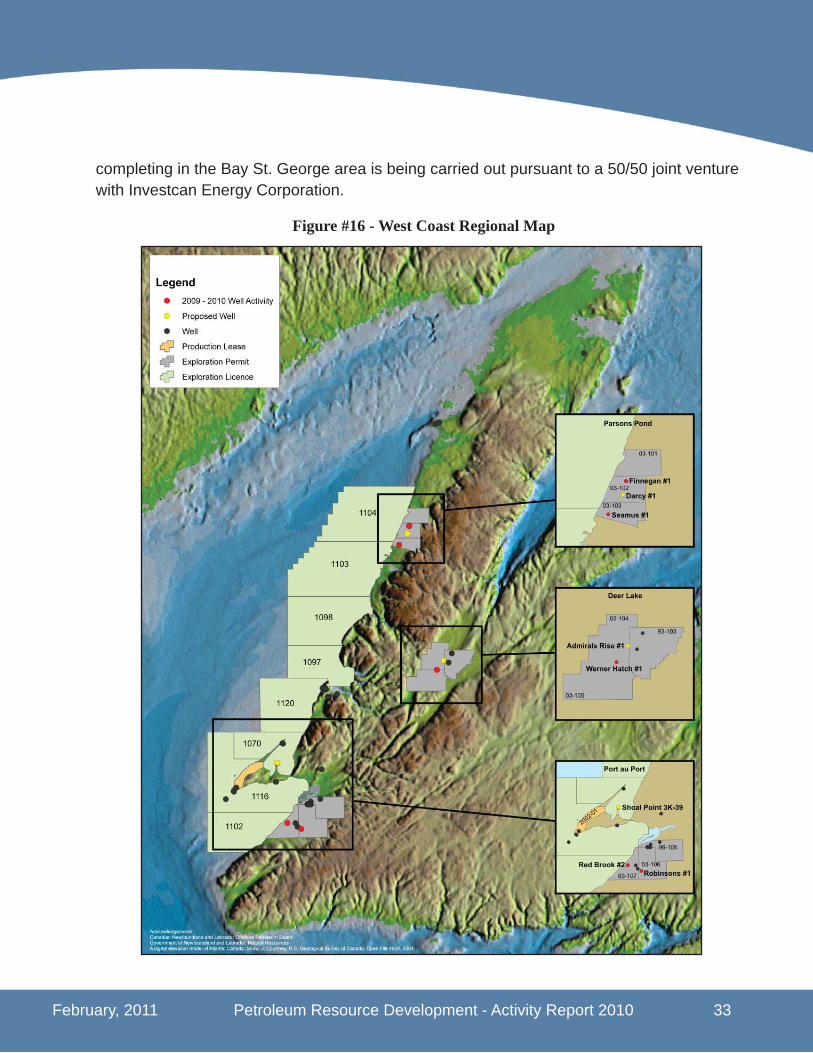
February, 2011 Petroleum Resource Development - Activity Report 2010 33
completing in the Bay St. George area is being carried out pursuant to a 50/50 joint venture with Investcan Energy Corporation.
Figure #16 - West Coast Regional Map

34 Petroleum Resource Development - Activity Report 2010 February, 2011
Deer Lake Area
Deer Lake Oil and Gas Inc. holds exploration permits EPs 93-103, 03-104 and 03-105 in the Deer Lake Basin. It drilled a shallow exploration well, Werner Hatch #1, utilizing the Logan #44 continuous coring drilling rig. The well was spudded on February 11, 2010 and released on March 31, 2010 after drilling to a total depth of 442 meters. Permitting for the Admirals Rise #1 well, also planned for the area, was in process as at December 31, 2010.
Exploration Activity - Offshore
Late in 2010 Shoal Point Energy announced plans for a follow up well to test the Green Point Formation within their shallow rights on EL1070. Shoal Point Energy and Canadian Imperial Venture Corporation hold the shallow rights as per an interest swap agreement with PDI Production Inc. Also Shoal Point Energy announced that it has repurchased its farm-out agreement with McLaren Resources which was signed in 2009.
Geoscience Programs - Offshore
Fugro Jacques Geosurveys completed a geohazard survey for Corridor Resources on their offshore exploration license EL-1105 in the Magdalen Basin. The survey, conducted utiliz-ing the M/V Anticosti, was completed on October 15, 2010 and a total of 147.5 kilometres of data was acquired.
Geoscience Programs – Onshore
Vulcan Minerals completed one of the largest seismic programs ever onshore western New-foundland over EPs 96-105, 03-106 and 03-107 located in the Bay St. George area. The program conducted from August 18, 2010 to November 14, 2010 collected 130 kilometers of data. Vulcan also completed a geochemical survey in the area to assist with seismic and structural interpretation of the Bay St. George Basin.
Licensing – Land Rights
As a result of fi nalizing requirements on Call for Bids NL 09-03, exploration license EL-1120 was issued to Ptarmigan Energy Inc. on January 15, 2010. The land parcel covers an area of 140,210 hectares in the Anticosti Basin as shown in fi gure 15 on page 33.

February, 2011 Petroleum Resource Development - Activity Report 2010 35
3.4 Labrador Offshore
Geoscience Programs
PGS completed a major 2D seismic program in the Hopedale Basin offshore Labrador utiliz-ing the M/V Harrier Explorer on behalf of Husky Energy. Husky Energy obtained approxi-mately 2300 kilometers of data covering their ELs 1106 and 1108 and a further 3200 kilome-ters of data around EL-1107 held by Investcan Energy.
SDL 208 Hopedale • 105 bcf gas • 2 million bbls NGLs SDL 185B North Bjarni
• 2247 bcf gas • 82 million bbls NGLs
SDL 185A Bjarni • 863 bcf gas • 31 million bbls NGLs
SDL 187 Gudrid • 924 bcf gas • 6 million bbls NGLs
SDL 187 Snorri • 105 bcf gas • 2 million bbls NGLs
Figure #17 - Labrador Regional Map

Appendix A

Appendix B
Photo CreditsC-NLOPBEMGS ExxonMobilHMDCHusky EnergyNOIASuncor EnergyProvincial Aerospace
