petra - ligona watermills valley and/or … - ligona watermills valley and/or petri - Αhillopigada...
TRANSCRIPT

PETRA - LIGONA WATERMILLS VALLEY and/or PETRI - ΑHILLOPIGADA - PETRA or MONASTIRELLIA (Ag. Dimitrios)-VAFEIOS 1. PETRA (ΟΤΕ). Starting point The starting point or end of the trail. The trail is type of circular at case A and crossing at case B with length 11625 meters (case A) or 9632 meters (case B), so the total distance you are going to travel, if you return to the starting point, is 11625 meters at case A. PETRA (ΟΤΕ). Starting point : Accessibility : Good Type Of Landscape : Petra Beach, exit of the stream, court, Regional medical center , OTE ,bunker Cultural Elements: Chapels-Churches, Architecture Facilities : Hostels, Dining Areas, Hotels Sign : Direction, Information From PETRA (ΟΤΕ). Starting point to Junction Junior High School : Distance between junctions : 456 Kind of road : Gravel road Accessibility : Good Type Of Landscape : Olive groves (plain) Difficulty of the trail : None Height difference (+ / - ) : 3 Slopping % : 1 Sign : Direction, Information 2. Junction Junior High School From Junction Junior High School to Moiradellia. Start of the path : Distance between junctions : 1202 Kind of road : Asphalt road and gravel road

Accessibility : Good Type Of Landscape : Greenfield, arable crops, commercial activities on the main road Difficulty of the trail : None Height difference (+ / - ) : 36 Slopping % : 5 Sign : Direction 3. Moiradellia. Start of the path From Moiradellia. Start of the path to Agia Foteini or Agia Fotia Chapel: Distance between junctions : 900 Kind of road : Wide stoned road Accessibility : Good Type Of Landscape : Arable crops, Junior High School-High School, complex of houses, olive groves (limits of the plain with sloping fields). Typical fence on the left of the entrance Difficulty of the trail : None Height difference (+ / - ) : 36 Slopping % : 8.2 Cultural Elements: Chapels-Churches, Architecture Natural Monuments : Valleys-Rivers, Flora, Fauna Sign : Direction, Information 4. Agia Foteini or Agia Fotia Chapel From Agia Foteini or Agia Fotia Chapel to Kato Ligona. Start of the path to Ano Ligona. : Distance between junctions : 351 Kind of road : Gravel road of low accessibility (almost abandoned) Accessibility : Good
Type Of Landscape : Shrub - tree-vegetation on the edge of the trail, olive groves (limits of the plain with sloping fields). In Agia Fotia there was the church and the cemetery millers in Ligona Difficulty of the trail : None Height difference (+ / - ) : 38 Slopping % : 15.7 Cultural Elements: Ancient-Monuments, Architecture Natural Monuments : Forests-Woodland, Valleys-Rivers, Flora, Fauna Facilities : Leisure Areas, Hostels Sign : Direction, Information 5. Kato Ligona. Start of the path to Ano Ligona. From Kato Ligona. Start of the path to Ano Ligona to Junction of the paths for mills in the south bank and mills of Ano Ligona. Distance between junctions : 3012 Kind of road : Dirt path Accessibility : Easy-Moderate Type Of Landscape : Shrub - tree-vegetation, olive groves. 4 Old abandoned windmills of pre-industrial period.Mandani Mill: consolidation work was made Difficulty of the trail : None Height difference (+ / - ) : 30 Slopping % : 19.6 Cultural Elements: Ancient-Monuments, Architecture Natural Monuments : Forests-Woodland, Valleys-Rivers, Flora, Fauna Facilities : Leisure Areas, Hostels Sign : Direction 6. Junction of the paths for mills in the south bank and mills of Ano Ligona.
From Junction of the paths for mills in the south bank and mills of Ano Ligona. to Branching of the paths for Vafeio and mills in Ano Ligona Distance between junctions : 158 Kind of road : Dirt and stoned path Accessibility : Easy-Moderate Type Of Landscape : Impressive rocky geomorphological formations columnar partition of volcanic rocks and tectonic aspects. Panoramic view of theLigona valley with old watermills Difficulty of the trail : None Height difference (+ / - ) : 29 Slopping % : 26.3 Cultural Elements: Ancient-Monuments, Architecture Natural Monuments : Forests-Woodland, Flora, Fauna Sign : Direction, 7. Branching of the paths for Vafeio and mills in Ano Ligona CASE A Branching of the paths for Vafeio and mills in Ano Ligona to Junction of the paths 100m. Before the sources Distance between junctions : 317 Kind of road : Dirt path Accessibility : Easy-Moderate Type Of Landscape : Ano Ligona watermills Arboreal vegetation with plane trees, walnuts etc, geomorphological formations on the edge of the valley, panoramic view of the valley Difficulty of the trail : None Height difference (+ / - ) : 99 Slopping % : 34.5 Cultural Elements: Ancient-Monuments, Monasteries, Architecture
Natural Monuments : Forests-Woodland, Valleys-Rivers, Flora, Fauna Sign : Direction CASE B Branching of the paths for Vafeio and mills in Ano Ligona to Magnificent rock with panoramic view Distance between junctions : 286 Kind of road : Dirt path Accessibility : Easy-Moderate Type Of Landscape : Panoramic view of the Ligona-Petra valley . Impressive rocky geomorphological formations. Difficulty of the trail : None Height difference (+ / - ) :6 Slopping % : 0.9 Natural Monuments : Flora The continue at CASE A 8. Junction of the paths 100m. Before the sources From Junction of the paths 100m. Before the sources to Ligona sources Distance between junctions : 87 Kind of road : Dirt path Accessibility : Good Type Of Landscape : Ano Ligona watermills . Arboreal vegetation with plane trees, walnuts etc. Difficulty of the trail : Easy Height difference (+ / - ) : -31 Slopping % : 8.5
Cultural Elements: Ancient-Monuments, Chapels-Churches, Monasteries, Architecture Natural Monuments : Forests-Woodland, Valleys-Rivers, Flora, Fauna Facilities : Leisure Areas, Hostels, Dining Areas, Hotels Sign : Direction, Information 9. Ligona sources From Ligona sources to Gravel road from Petri for Ligona sources Distance between junctions : 126 Kind of road : Dirt path Accessibility : Easy Type Of Landscape : Arboreal riparian vegetation with plane trees etc. Manholes of water supply Difficulty of the trail : Easy-moderate Height difference (+ / - ) : 14 Slopping % : 28.3 Natural Monuments : Forests-Woodland, Valleys-Rivers, Flora, Fauna Facilities : Leisure Areas, Hostels Sign : Direction, Information 10. Gravel road from Petri for Ligona sources From Gravel road from Petri for Ligona sources to Gravel road from Petri for Ligona sources Distance between junctions : 364 Kind of road : Dirt path and gravel road Accessibility : Easy

Type Of Landscape : Panoramic view of the Ligona valley with old watermills. Impressive rocky geomorphological formations. Difficulty of the trail : None Height difference (+ / - ) : -23 Slopping % : 18.4 Cultural Elements: Architecture Natural Monuments : Forests-Woodland, Valleys-Rivers, Flora, Fauna Sign : Direction, Information 11. Gravel road from Petri for Ligona sources From Gravel road from Petri for Ligona sources to Vafeio to Branching of the gravel road to Ahilliopigada Distance between junctions : 482 Kind of road : Gravel road Accessibility : Good Type Of Landscape : Shrub - tree-vegetation, farming activities and facilities Difficulty of the trail : None Height difference (+ / - ) : 2 Slopping % : 10.4 Natural Monuments : Forests-Woodland, Flora, Fauna Sign : Direction 12. Branching of the gravel road to Ahilliopigada
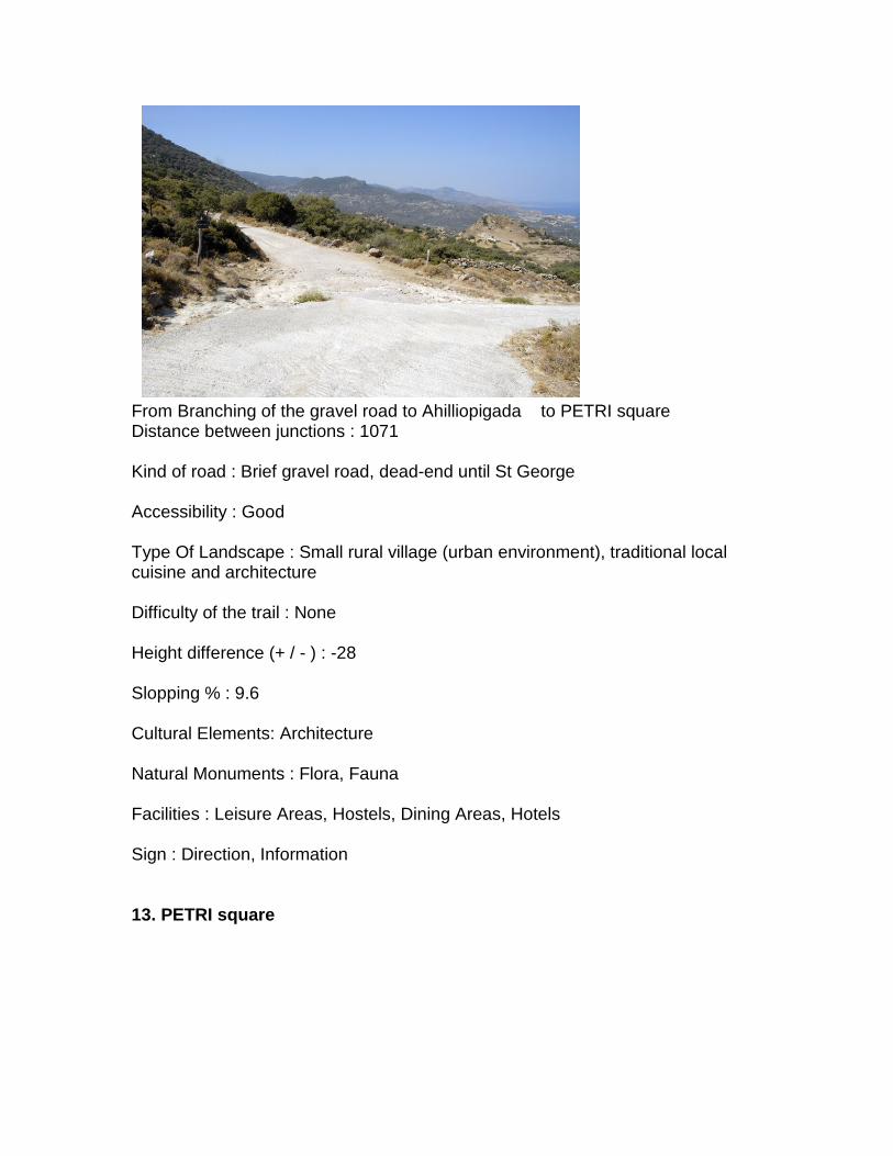
From Branching of the gravel road to Ahilliopigada to PETRI square Distance between junctions : 1071 Kind of road : Brief gravel road, dead-end until St George Accessibility : Good Type Of Landscape : Small rural village (urban environment), traditional local cuisine and architecture Difficulty of the trail : None Height difference (+ / - ) : -28 Slopping % : 9.6 Cultural Elements: Architecture Natural Monuments : Flora, Fauna Facilities : Leisure Areas, Hostels, Dining Areas, Hotels Sign : Direction, Information 13. PETRI square

From PETRI square to PETRI church Distance between junctions : 125 Kind of road : Paved and stoned alley Accessibility : Good Type Of Landscape : Small rural village (urban environment), 18th-century church Difficulty of the trail : Easy Height difference (+ / - ) : -7 Slopping % : 26.6 Cultural Elements: Chapels-Churches, Architecture Natural Monuments : Forests-Woodland, Valleys-Rivers, Flora, Fauna Facilities : Leisure Areas, Hostels Sign : Direction, Information 14. PETRI church

From PETRI church to Exit to gravel road for Ahilliopigada Distance between junctions : 565 Kind of road : Dirt path Accessibility : Easy Type Of Landscape : Shrub - tree vegetation, farming activities, panoramic view of Petra-Petri rocky formations Difficulty of the trail : None Height difference (+ / - ) : -85 Slopping % : 26 Natural Monuments : Flora, Fauna Sign : Direction 15. Exit to gravel road for Ahilliopigada

Exit to gravel road for Ahilliopigada to Ahilliotripa. Junction of gravel roads. Entrance to the path Distance between junctions : 393 Kind of road : Gravel road Accessibility : Good Type Of Landscape : Impressive geomorphological rocky formations with a large hole in the middle of an isolated volcanic rock (called Ahilleiotrypa, according to the myth that Achilleas tied his ship there when he went to Troy). Difficulty of the trail : None Height difference (+ / - ) : 0 Slopping % : 5 Sign : Direction 16. Ahilliotripa. Junction of gravel roads. Entrance to the path From Ahilliotripa. Junction of gravel roads. Entrance to the path to AHILLIOPIGADA Distance between junctions : 173 Kind of road : Dirt and stoned path through streams Accessibility : Moderate Type Of Landscape : Abandooned Turkish settlement Difficulty of the trail : Easy
Height difference (+ / - ) : -17 Slopping % : 17.6 Cultural Elements: Ancient-Monuments, Architecture Sign : Information 17. AHILLIOPIGADA From AHILLIOPIGADA to Exit to gravel road which leads to the complex of houses Distance between junctions : 721 Kind of road : Dirt path Accessibility : Good-Moderate Type Of Landscape : Abandoned Turkish settlement , stream vegetation, new housing complexes Difficulty of the trail : Easy-Moderate Height difference (+ / - ) : -61 Slopping % : 16.1 Cultural Elements: Ancient-Monuments, Architecture Natural Monuments : Valleys-Rivers, Flora, Fauna Sign : Direction 18. Exit to gravel road which leads to the complex of houses From Exit to gravel road which leads to the complex of houses to Exit to the asphalt to PETRI Distance between junctions : 73 Kind of road : Gravel road Accessibility : Good Type Of Landscape : bushy,tree-covered vegetation Difficulty of the trail : None

Height difference (+ / - ) : -11 Slopping % : 17.9 Sign : Direction, Information 19. Exit to the asphalt to PETRI From Exit to the asphalt to PETRI to Junction with the main asphalt road to Petra-Molyvo Distance between junctions : 446 Kind of road : Asphalt road Accessibility : Good Type Of Landscape : Greenfield, arable crops, commercial activities near the main road, Difficulty of the trail : None Height difference (+ / - ) : -20 Slopping % : 7 Sign : Direction 20. Junction with the main asphalt road to Petra-Molyvo
From Junction with the main asphalt road to Petra-Molyvo to PETRA (Center, Panagia rock , waterfront ) Distance between junctions : 776 Kind of road : Paved and stoned alley
Accessibility : Good Type Of Landscape : Traditional settlement, Panagia rock, tourist activities Difficulty of the trail : None Height difference (+ / - ) : -4 Slopping % : 0.9 Cultural Elements: Ancient-Monuments, Chapels-Churches, Architecture Facilities : Leisure Areas, Hostels, Dining Areas, Hotels Sign : Information 21. PETRA (Center, Panagia rock , waterfront ) It is the end or the starting point of our trail. (The continue at CASE B) 22. Magnificent rock with panoramic view From Branch to traditional ranching "mantra" or "Saya") to Monastirellia Distance between junctions : 235 Kind of road : Dirt path Accessibility : Good-Moderate Type Of Landscape : Rural area with arable crops, abundant water, a small plain with large terraces on the boundaries with sloping bushy forest vegetation. A typical fence on the left of the entrance Difficulty of the trail : Easy-Moderate Height difference (+ / - ) : 34 Slopping % : 26 Cultural Elements: Architecture Natural Monuments : Flora, Fauna Sign : Direction
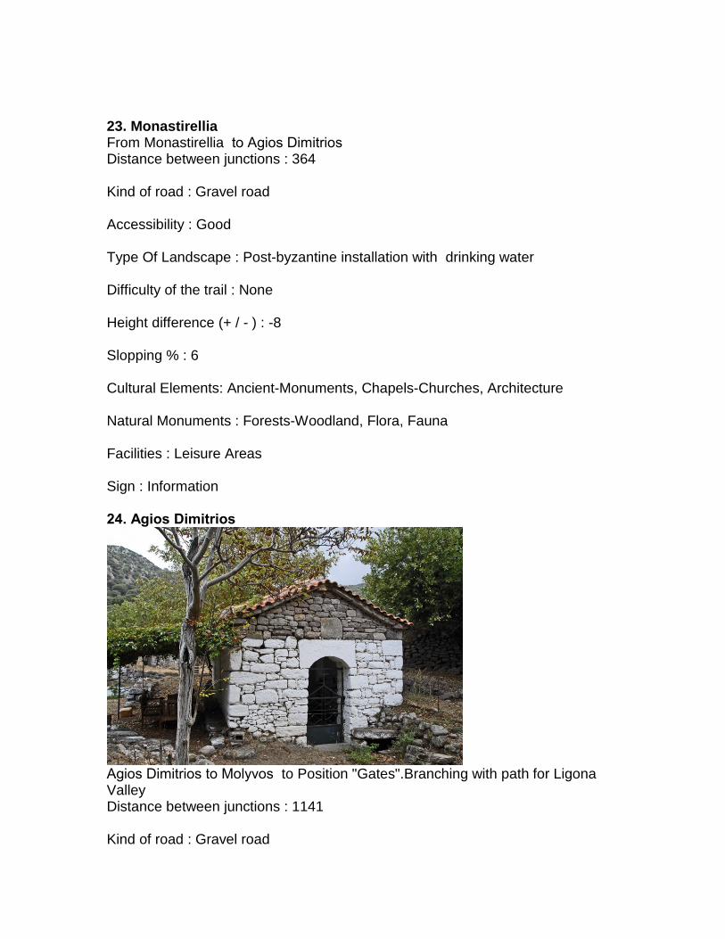
23. Monastirellia From Monastirellia to Αgios Dimitrios Distance between junctions : 364 Kind of road : Gravel road Accessibility : Good Type Of Landscape : Post-byzantine installation with drinking water Difficulty of the trail : None Height difference (+ / - ) : -8 Slopping % : 6 Cultural Elements: Ancient-Monuments, Chapels-Churches, Architecture Natural Monuments : Forests-Woodland, Flora, Fauna Facilities : Leisure Areas Sign : Information 24. Αgios Dimitrios
Αgios Dimitrios to Molyvos to Position "Gates".Branching with path for Ligona Valley Distance between junctions : 1141 Kind of road : Gravel road

Accessibility : Good Type Of Landscape : Shrub - tree vegetation, Livestock farming, crops, panoramic view of Petra-Petra and Molyvos Vofeio-rocky formations Difficulty of the trail : None Height difference (+ / - ) : -3 Slopping % : 7.7 Natural Monuments : Forests-Woodland, Valleys-Rivers, Flora, Fauna Sign : Direction 25. Position "Gates".Branching with path for Ligona Valley
From Position "Gates".Branching with path for Ligona Valley to VAFEIOS.Branching with path to the top of Profiti Helias in Lepetymno Distance between junctions : 1210 Kind of road : Gravel road Accessibility : Good Type Of Landscape : Small rural village (urban environment), traditional local cuisine and products Difficulty of the trail : None Height difference (+ / - ) : 22

Slopping % : 12.1 Cultural Elements: Chapels-Churches Natural Monuments : Forests-Woodland, Fauna Facilities : Leisure Areas, Hostels, Dining Areas, Hotels Sign : Direction 26. VAFEIOS.Branching with path to the top of Profiti Helias in Lepetymno
It is the end or the starting point of our trail.