persistently low asian paleolatitudes: implications for
TRANSCRIPT

Persistently low Asian paleolatitudes:Implications for the India‐Asia collision history
Guillaume Dupont‐Nivet,1,2 Douwe J. J. van Hinsbergen,3,4 and Trond H. Torsvik3,5,6
Received 9 December 2008; revised 4 June 2010; accepted 15 June 2010; published 14 October 2010.
[1] Paleomagnetism provides independent paleo-latitude constraints on the India‐Asia convergence.However, implied Cenozoic latitudinal convergencewithin Asia (thousands of km) largely exceeds geologicestimates of tectonic shortening (hundreds of km). Thisdiscrepancy may result from a notoriously low bias inpaleomagnetically determined Cenozoic paleolatitudesin Asia. We provide here new paleomagnetic data fromCenozoic Mongolian volcanic rocks and from ChinesePaleogene sediments corrected from the depositionalbias of inclination shallowing. These results combinedwith similar Asian data sets, confirm that paleolatitudesare still 5–10° lower than predicted by the paleomag-netic Apparent Polar Wander Path (APWP) for Asiabetween 50 and 20 Ma. Inclination‐shallowing beingexcluded from the selected data sets, we investigatethe likeliness of other proposed mechanisms for thisdiscrepancy: (1) more southerly positions of Asia thanexpected by the APWP (due to APWP inaccuraciesrather than Eurasian non‐rigidity), or (2) non‐dipolargeomagnetic field contributions. Fully explainingthis discrepancy by only one of these mechanismswould imply either unrealistically large (>10°) APWPinaccuracies, or unrealistically large octupolar fieldcontributions (up to 16%). A combination of thesemechanisms is found more likely to have produced theobserved latitudinal discrepancy, but their respectivecontributions cannot be quantified given the stillrelatively low amount and poor quality of Cenozoicpaleomagnetic data from stable cratons of Asia, India,and Europe. By allowing for reasonable time‐dependantnon‐dipolar contributions and a slight (<5°) APWPbias, the latitudinal discrepancy can be resolved and theexcessive amounts of intra‐Asian shortening decreaseto values in line with tectonic shortening from structural
studies. Citation: Dupont‐Nivet, G., D. J. J. van Hinsbergen,and T. H. Torsvik (2010), Persistently low Asian paleolatitudes:Implications for the India‐Asia collision history, Tectonics, 29,TC5016, doi:10.1029/2008TC002437.
1. Introduction[2] The Cenozoic India‐Asia convergence resulted in
the formation of the Tibetan Plateau (Figure 1), the highestelevated landmass on the planet, with major repercussionson regional environments and possibly on global climate[Ruddiman et al., 1997; Tapponnier et al., 2001]. Despite itsimportance and decades of research, the convergence historyand the timing and of the collision between these continentsremains controversial [Aitchison et al., 2008; Copley et al.,2010; Garzanti, 2008; Molnar and Stock, 2009]. The conti-nental convergence history is based mainly on two data sets.India‐Asia relative convergence rates and amounts are esti-mated through time using plate kinematic reconstructionsbuilt on the basis of Euler poles determined from marinemagnetic anomalies defining a plate circuit [Cox and Hart,1986]. The position through time of the plate circuit withrespect to Earth’s magnetic field is constrained by paleo-magnetic data from all continents rotated into a syntheticglobal Apparent Polar Wander Path (APWP) using the platecircuit [Besse and Courtillot, 2002; Cox and Hart, 1986;Schettino and Scotese, 2005; Torsvik et al., 2008]. Thepaleolatitudes of terranes that are not incorporated in the platecircuit – such as the Tethyan Himalayas, the Lhasa or theQiangtang terranes between India and Siberia – can bedetermined independently with paleomagnetic data directlyfrom these terranes. These can be compared to paleolatitudesof the bounding plates (i.e., India or Eurasia) constrained bythe global APWP in order to quantify their respective latitu-dinal motion. Despite its importance for kinematic recon-structions, the paleomagnetic database on which the APWP isbased is sparse and its interpretation is not straightforward. Inparticular, Cenozoic Asian inclinations appear to be signifi-cantly (>10°) lower than predicted by the APWP [Cognéet al., 1999; Hankard et al., 2007a]. This directly hamperspaleolatitude estimates of India and Asia, and their use indetermining convergence rates and convergence magnitudesof terranes with respect to India or Siberia.[3] The cause for the shallow ‘bias’ in Asian paleomagnetic
inclinations is the topic of a longstanding debate. Proposedcauses include: (1) more southerly position of Asia due totectonic decoupling of Asia fromEurasia during the Cenozoic[Ali and Aitchison, 2006;Cogné et al., 1999]; (2) non‐dipolar(mostly octopular) contributions to the otherwise dipolargeomagnetic field [Chauvin et al., 1996; Si and Van der Voo,
1Paleomagnetic Laboratory “Fort Hoofddijk,” Faculty of Geosciences,Utrecht University, Utrecht, Netherlands.
2Key Laboratory of Orogenic Belts and Crustal Evolution, Ministry ofEducation, Peking University, Beijing, China.
3Physics of Geological Processes, University of Oslo, Oslo, Norway.4Department of Geology, Leicester University, Leicester, UK.5Also at Center for Geodynamics, NGU, Trondheim, Norway.6Also at School of Geosciences, University of the Witwatersrand,
Johannesburg, South Africa.
Copyright 2010 by the American Geophysical Union.0278‐7407/10/2008TC002437
TECTONICS, VOL. 29, TC5016, doi:10.1029/2008TC002437, 2010
TC5016 1 of 19

2001]; (3) ‘inclination shallowing’ during deposition andcompaction of sediments [Dupont‐Nivet et al., 2002; Gilderet al., 2001; Tan et al., 2003; Tauxe, 2005], or a combina-tion of these causes.[4] To better constrain the Asian inclination anomaly, as
basis for a discussion on its possible mechanisms and itsimplications on the India‐Asia collision, we provide in thispaper: (1) new paleomagnetic data from 40, 30 and 10 Mavolcanic rocks from Mongolia and (2) a careful review ofreliable Asian paleomagnetic data sets (exclusively fromvolcanic rocks or from shallowing‐corrected sedimentaryrocks).
2. New Paleomagnetic Data From CenozoicVolcanics of Mongolia[5] Paleomagnetic poles are best determined from paleo-
magnetic data obtained fromwell‐bedded volcanic sequencesin stable continental regions. The Gobi Altai region inMongolia (Figure 1) has belonged to stable Eurasia since thelate Jurassic [Cogné et al., 1999; Hankard et al., 2007a; Vander Voo et al., 1999; van Hinsbergen et al., 2008]. Between∼190Ma and the lateMiocene, the region has undergone littleor no internal deformation or erosion prior to the lateMiocene
strike‐slip dominated deformation [Jolivet et al., 2007;Vassallo et al., 2007]. Similarity between CretaceousMongolian poles and the APWP led van Hinsbergen et al.[2008] to suggest that late Cenozoic deformation did notinvolve vertical axis rotations. As such, paleomagnetic polesobtained from post‐Jurassic lavas from the Gobi Altai canbe considered to reflect the paleoposition of stable Eurasia.Recently, Hankard et al. [2007a] provided paleomagneticresults from Cenozoic volcanic and shallow intrusive bodiesin the Gobi Altai and the Valley of Lakes (Figure 2). Here,we report new paleomagnetic data from the same region (andin one case from the same locality) to determine Asian polesat ∼40, ∼30 and ∼10 Ma.
2.1. Geological Setting and Sampling
[6] TheGobi Altai exposes Paleozoic basement overlain bysome Jurassic, and mainly lower Cretaceous basalts and ter-restrial sediments [Jolivet et al., 2007; van Hinsbergen et al.,2008], as well as scattered Cenozoic basaltic lavas and shal-low intrusive basaltic plugs with ages ranging from ∼40 to∼10 Ma [Barry et al., 2003; Devyatkin and Smelov, 1980;Hankard et al., 2007b; Höck et al., 1997; Whitford‐Stark,1987]. The latter were the target of our paleomagnetic sam-
Figure 1. Digital elevation model (scale is in kilometers above sea level: km a.s.l.) with location of sam-pling (box labeled Figure 2) and numbered paleomagnetic data sets included in the compilation (only fromvolcanic rocks and shallowing‐corrected sediments).
Figure 2. Earth satellite image of the Gobi Altai with the main structural elements and sampling locations. TB = Tsagaan-botga rhyolite plug. The Sevrei plateau is located southeast of this region. Field photographs show the sampling locations andan impression of the topography and structure of the region.
DUPONT-NIVET ET AL.: PERSISTENTLY LOW ASIAN PALEOLATITUDES TC5016TC5016
2 of 19

Figure 2
DUPONT-NIVET ET AL.: PERSISTENTLY LOW ASIAN PALEOLATITUDES TC5016TC5016
3 of 19

pling. The Gobi Altai mountain range probably forms a far‐field effect of the India‐Asia collision and is dominated bytranspressional strike‐slip motion along elongated ∼ENE‐WSW trending restraining bends [Bayasgalan et al., 1999;Cunningham, 2005, 2007; Cunningham et al., 1996, 1997].It is important to note here that the ∼ENE‐WSW trend ofthese restraining bends implies that associated tilting may beto the north or south, thus potentially influencing inclination/paleolatitude estimates. It is therefore important to accuratelydetermine post‐depositional tilting.[7] Paleomagnetic sampling of 288 samples from 37 lava
sites was performed using a water‐cooled, gasoline‐powered,motor drill. To exclude any local magnetic deviations, theorientation of all samples was measured with both a magneticand a sun compass, and magnetic measurements were cor-rected for the present‐day declination. Sampling was per-formed at three localities of ∼40, 30 and 10 Ma, respectively:[8] 1. The oldest sampled locality (39.4 ± 0.6Ma [Hankard
et al., 2007b]) consists of a small array of columnar jointedbasaltic plugs, the largest one of which is called Khaton Sudal(‘Queen’s Seat’), rising ∼50 m above the surrounding plains(Figure 2). We collected 49 samples from 7 sites from theseplugs. Similar to Hankard et al. [2007b], we assume theseplugs not been affected by significant tilt, as suggestedby the negligible (<2°) slope of the surrounding alluvialplains which probably represent the underlying, pre‐intrusivebedding.[9] 2. A volcanic episode occurring around 30 Ma is pre-
served in several basaltic plateaus of a few km2. On the Bogdplateau we collected 98 samples at 14 sites, and on the Jaranplateau we collected 70 samples from 10 sites (Figure 2).Barry et al. [2003] obtained 40Ar/39Ar ages from the Bogdplateau lavas of 33.0 ± 0.3 and 32.4 ± 0.4 Ma, and fromsimilar lavas from the Sevrei plateau further south at 30.3 ±0.1 Ma. The Jaran Plateau is a lava plateau of similar size,
lithology (dark, glassy pahoehoe lavas) and regional setting.Because it has never been directly dated, we confirmed thiscorrelation through geochemistry analysis using a NITONXRF analyzer. Major element mapping shows that sampledlavas from the Bogd and Jaran plateaus have a commonsignature that is noticeably distinct from the widespreadCretaceous, Khaton Sudal or Neogene lavas (Figure 3).Bedding of the Jaran and Bogd plateaus is 2–3° in E‐SEdirection (Table 1). Although potentially primary, we choseto correct for this very minor bedding tilt. Given the strongE‐component of the tilt, correction does not lead to sig-nificant changes of the inclination.[10] 3. A set of 70 samples was collected at 10 sites in
young lavas that fill a paleovalley next to the Jaran Plateau,here depicted as ‘Jaran Bogd Neogene lavas’ (Figure 2).These lavas originated from the only volcano that is stillevident in the Gobi Altai region (the Jaran Bogd volcano),and form isolated flows from the crater to the east and south,over a distance of up to ∼20 km. Given the absence ofradiometric ages on these lavas, we estimate their time ofdeposition to be late Miocene‐Pliocene based on crosscuttingrelationships. They fill a paleovalley that formed next to theJaran Plateau. The valley must post‐date the eruption ofthe Jaran Plateau (JP) lavas. The paleovalley formed at thenorthern edge of Mt. Ih Bogd on which Jolivet et al. [2007]and Vassallo et al. [2007] dated an uplifted peneplain andshowed that this erosion surface most likely formed in theJurassic, and was not demonstrably incised until the uplift ofthe Ih Bogd restraining bend, the onset of which they dated at5 ± 3 Ma by apatite fission track analysis. The present‐dayvalley is located west of the youngest lavas, and incisedseveral tens of meters deeper. Given these crosscuttingrelationships, the paleomagnetic results from these upperMiocene to Pliocene lavas are expected to range between thepresent‐day field and the ∼10 Ma paleopole obtained in theValley of Lakes [Hankard et al., 2007a]. Both the plateauand the upper Miocene‐Pliocene lavas unconformably covera folded, 1000–1500 m thick sequence of lower Cretaceousbasalts [van Hinsbergen et al., 2008]. Given the very minortilt of the Jaran Plateau, we have not applied a tilt correctionfor the Neogene lavas.[11] Finally, 28 samples were collected at 4 sites from
a rhyolite plug on the southern flank of Baga Bogd(Tsagaanbotga), but these did not yield interpretable paleo-magnetic directions (Table 1).
2.2. Paleomagnetic Procedures
[12] The samples were demagnetized using either thermal(TH) or alternating field (AF) progressive demagnetization.Heating took place in a magnetically shielded, laboratory‐built furnace using small temperature increments of 20–80°Cup to temperatures of 640°C. AF demagnetization was carriedout with 5–20 mT increments up to 120 mT. For all samples,the natural remanent magnetization (NRM) of the specimenswas measured on a 2G Enterprises horizontal DC SQUIDcryogenic magnetometer (noise level 3 × 10⁻¹²Am2). ForAF demagnetization, the instrument was interfaced withan in‐house developed robot‐assisted automated measuringdevice.
Figure 3. Major element concentration (K and Ti given inequivalent % weight) showing the signatures of lavas fromthe Bogd Plateau (BP), Jaran Plateau (JP), Jaran Neogene(JN) and Khaton Sudal (KS).
DUPONT-NIVET ET AL.: PERSISTENTLY LOW ASIAN PALEOLATITUDES TC5016TC5016
4 of 19

Tab
le1.
Paleomagnetic
Site
Means
andPoles
From
Mon
golianDataa
Lat
Lon
Typ
eNa
Nc
Tilt
Strike/Dip
Tilt
Corrected
Pol
Age
(Ma)
l8
�A95
Palat
DDD
IDI
ka95
JaranBog
dNeogene
66
78.1
−111
.130
.012
.434
.37.6
15.1
53.8
12.7
n/r
<8(see
text)
JNI
44.869
710
0.71
937
700
0/00
78.8
174.2
195.9
‐64.9
134.6
5.2
rJN
II44
.834
210
0.88
687
700
0/00
69.9
−106
.610
.244
.982
.76.7
nJN
III
44.834
310
0.88
607
700
0/00
66.2
−137
.223
.248
.663
.17.7
nJN
IV44
.835
010
0.88
647
700
0/00
68.4
−91.7
5.0
41.2
267.1
3.7
nJN
V44
.834
410
0.88
757
700
0/00
81.6
−98.1
3.4
56.3
463.3
2.8
nJN
VI‐X
44.825
810
0.79
0235
3300
0/00
76.9
18.5
341.5
63.5
465.1
1.2
nJaranPlateau
Olig
ocene
106
76.8
43.7
45.8
10.0
50.6
162.4
15.9
−67.7
7.2
r30
(?)(see
text)
JPI
44.841
410
0.68
477
706
5/02
SE
73.1
3.5
157.7
−59.5
153.5
4.9
rJP
II44
.841
910
0.68
477
706
5/02
SE
86.4
46.9
175.8
−64.8
519.8
2.7
rJP
III
44.843
310
0.68
437
706
5/02
SE
50.4
61.2
116.1
−75.7
254.7
3.8
rJP
IV44
.850
610
0.67
64gc
66
065/02
SE
64.5
31.9
142.8
−65.9
51.0
9.5
rJP
V44
.843
010
0.67
35gc
75
065/02
SE
72.4
85.2
170.3
−74.7
121.5
7.0
rJP
VI
44.842
510
0.67
077
706
5/02
SE
‐‐
66.9
−75.3
2.8
44.1
LJP
VII
44.841
210
0.67
157
606
5/02
SE
81.2
−113
.518
6.2
−56.7
132.2
5.8
rJP
VIII
44.839
610
0.67
30gc
77
065/02
SE
‐‐
154.6
−70.3
4.4
32.5
LJP
IX44
.839
110
0.67
467
706
5/02
SE
‐‐
237.4
−20.5
2.6
47.8
LJP
X44
.837
510
0.68
45gc
77
065/02
SE
‐‐
255.3
−71.5
20.2
13.7
nBog
dPlateau
118
74.4
−100
.892
.85.8
30.2
187.0
6.7
−49.3
6.6
r30
.3±0.1
[Barry
etal.,20
03]
BPI
44.751
710
2.30
847
002
2/03
E‐
‐‐
‐‐
‐L
BPII,IV
44.752
610
2.30
6814
1402
2/03
E73
.6−9
7.6
186.3
−48.0
254.4
2.5
rBPIII,V,VI
44.752
910
2.30
4421
1802
2/03
E76
.8−1
16.8
190.0
−53.4
218.3
2.3
rBPVII
44.751
710
2.28
837
702
2/03
E71
.9−1
01.9
188.3
−46.5
197.6
4.3
rBPVIII
44.686
010
2.27
337
002
7/03
E‐
‐‐
‐‐
‐L
BPIX
44.686
110
2.27
09gc
77
027/03
E71
.9−8
4.9
182.5
−45.0
506.0
2.7
rBPX
44.686
310
2.26
89gc
77
027/03
E77
.1−1
56.7
196.9
−59.9
451.9
2.8
rBPXI
44.685
310
2.26
707
702
7/03
E73
.8−1
09.9
189.9
−49.6
122.3
5.5
rBPXII
44.684
810
2.25
847
702
7/03
E70
.1−1
29.7
198.2
−49.9
109.3
5.8
rBPXIII
44.685
410
2.25
59gc
76
027/03
E‐
‐16
3.9
−40.9
22.5
14.4
rBPXIV
44.684
510
2.25
50gc
76
027/03
E66
.4−5
4.4
170.1
−39.6
157.1
4.8
rBP+JP
44.684
510
2.25
5014
1381
.6−8
5.5
25.1
8.4
36.2
181.4
10.4
−55.7
8.2
KhatonSud
al7
776
.7−1
10.9
45.1
9.1
32.8
188.4
10.8
−52.2
9.7
r39
.4±0.6
[Han
kard
etal.,20
07a]
KSI
44.489
910
1.33
80gc
75
?71
.6−1
10.8
191.0
−47.0
78.2
8.7
rKSII
44.493
110
1.33
767
7?
80.2
−22.1
169.5
−57.8
551.3
2.6
rKSIII
44.500
110
1.33
757
6?
77.0
−162
.919
7.5
−60.7
129.2
5.9
rKSIV
44.500
810
1.33
717
7?
76.3
−142
.919
5.6
−56.7
200.9
4.3
rKSV
44.501
110
1.33
64gc
76
?59
.6−1
08.4
195.2
−31.2
58.8
7.9
rKSVI
44.502
510
1.33
757
7?
75.6
−101
.718
6.5
−50.2
940.9
2.0
rKSVII
44.503
410
1.33
777
6?
85.7
−70.6
179.2
−59.3
632.5
2.7
r
DUPONT-NIVET ET AL.: PERSISTENTLY LOW ASIAN PALEOLATITUDES TC5016TC5016
5 of 19

Tab
le1.
(con
tinued)
Lat
Lon
Typ
eNa
Nc
Tilt
Strike/Dip
Tilt
Corrected
Pol
Age
(Ma)
l8
�A95
Palat
DDD
IDI
ka95
Tsagaanbo
tga
42
0.0
0.0
‐‐
r?
TBI
44.742
410
1.72
4236
7gc
76
000/00
65.7
−14.8
154.6
−49.9
110.6
6.4
rTBII
44.742
310
1.72
4036
77
600
0/00
‐‐
163.3
−43.2
12.1
20.0
rTBIII
44.742
410
1.72
3856
77
600
0/00
‐‐
225.2
−54.1
6.8
27.8
rTBIV
44.742
110
1.72
3946
77
600
0/00
35.2
9.5
117.9
−39.7
55.5
9.1
rKhatonSud
al[H
ankard
etal.,20
07a]
86
70.4
−152
.474
.87.8
36.4
203.6
9.7
−55.9
7.6
39.4
±0.6
[Han
kard
etal.,20
07a]
8744
.510
1.4
99
?19
3.1
−64.1
37.1
8.6
r88
44.5
101.4
99
?76
.5−1
49.8
196.5
−58.2
969.1
1.7
r89
44.5
101.4
99
?64
.0−1
71.0
214.9
−59.2
149.5
4.2
r90
44.5
101.4
99
?58
.7−1
62.2
218.5
−53.3
351.5
2.8
r91
44.5
101.4
76
?68
.6−1
31.6
199.6
−48.8
65.5
8.3
r92
44.5
101.4
98
?62
.2−2
8.1
‐‐
r93
44.5
101.4
88
?75
.7−1
57.4
199.0
−68.0
293.5
3.2
r94
44.5
101.4
87
?74
.7−1
27.8
193.9
−53.0
360.3
3.2
rTaatsyn
Gol
1[H
ankard
etal.,20
07a]
b19
1578
.1−8
2.6
74.7
4.5
33.5
181.0
5.4
−53.0
4.7
31.5
±0.7
[Han
kard
etal.,20
07a]
145
.410
1.3
76
?78
.0−1
16.5
189.0
−55.0
204.4
4.7
r2
45.4
101.3
77
?70
.2−8
0.6
180.7
−43.8
139.2
5.4
r3
45.4
101.3
76
?74
.7−1
16.3
191.0
−52.1
111.2
6.4
r20
45.4
101.3
88
?82
.5−5
5.3
176.2
−57.8
282.4
3.6
r21
45.4
101.3
76
?77
.4−6
7.5
177.1
−52.4
629.3
2.2
r22
45.4
101.3
76
?79
.9−7
6.4
179.5
−54.8
378.0
3.5
r23
45.4
101.3
77
?75
.2−7
.616
1.9
−58.4
117.0
6.2
r24
45.4
101.3
94
?79
.4−7
1.1
178.3
−54.3
605.7
2.6
r74
45.4
101.3
99
?19
.1−3
.611
3.8
−7.1
67.6
11.3
r75
45.4
101.3
1916
?72
.1−9
5.6
185.8
−46.9
61.7
6.6
r76–78
45.4
101.3
2018
?‐
‐17
7.5
−53.7
44.5
5.6
r77–79
45.4
101.3
99
?75
.7−8
3.2
181.3
−50.4
110.5
3.3
r90
45.4
101.3
98
?‐
‐18
1.1
−51.6
27.8
9.9
r81
45.4
101.3
1010
?76
.6−9
9.5
185.6
−52.1
150.1
4.5
r82
45.4
101.3
99
?72
.298
.117
7.8
−75.8
55.1
6.7
r83
45.4
101.3
119
?68
.8−7
6.9
179.3
−41.9
167.7
4.0
r84
45.4
101.3
99
?80
.9−7
6.2
179.5
−55.8
88.2
5.5
r85
45.4
101.3
95
?81
.434
.416
8.1
−65.9
97.2
5.3
r86
45.4
101.3
1918
?65
.0−1
13.5
195.3
−41.2
138.9
6.5
r
DUPONT-NIVET ET AL.: PERSISTENTLY LOW ASIAN PALEOLATITUDES TC5016TC5016
6 of 19

Tab
le1.
(con
tinued)
Lat
Lon
Typ
eNa
Nc
Tilt
Strike/Dip
Tilt
Corrected
Pol
Age
(Ma)
l8
�A95
Palat
DDD
IDI
ka95
Taatsyn
Gol
2[H
ankard
etal.,20
07a]
b8
889
.218
6.3
139.3
4.7
45.6
1.1
6.7
63.9
3.7
28.0
±0.8
[Han
kard
etal.,20
07a]
1245
.510
1.1
77
?81
.0−5
2.7
355.0
56.7
105.1
5.9
n13
45.5
101.1
76
?87
.0−1
08.3
2.0
61.7
156.9
5.4
n14
45.5
101.1
77
?84
.5−1
32.5
6.0
61.0
638.7
2.4
n15
45.5
101.1
77
?78
.312
2.1
7.5
71.5
287.4
3.6
n16
45.5
101.1
77
?88
.015
2.5
2.3
64.8
497.3
2.7
n17
45.5
101.1
77
?86
.083
.835
8.2
66.7
342.8
3.3
n18
45.5
101.1
66
?84
.3−1
4.0
353.0
61.7
225.6
4.5
n19
45.5
101.1
87
?84
.9−1
79.6
7.3
64.4
422.3
3.9
nTaatsyn
Gol
3[H
ankard
etal.,20
07a]
b7
669
.615
8.2
13.5
12.7
43.8
205.6
17.7
−62.5
10.4
12.7
±0.6
[Han
kard
etal.,20
07a]
445
.510
1.0
77
?66
.6−1
50.3
207.1
−53.9
129.3
5.7
545
.510
1.0
77
?73
.3−1
46.7
199.5
−56.8
339.3
3.4
645
.510
1.0
98
?63
.7−1
58.3
212.4
−55.0
156.0
5.0
745
.510
1.0
88
?44
.015
8.0
251.1
−67.5
93.2
5.8
845
.510
1.0
66
?‐
‐21
8.4
−77.1
28.8
12.7
1045
.510
1.0
74
?77
.7−9
2.8
183.5
−52.9
98.0
10.8
1145
.510
1.0
77
?64
.710
1.5
180.7
−80.1
90.4
6.4
040
Ma
44.5
101.4
1313
75.3
−135
.338
.26.8
35.2
195.1
8.3
−54.7
6.8
30Ma
44.5
101.4
3936
82.3
−90.6
61.3
3.1
36.9
182.0
3.9
−56.3
3.0
10Ma
44.5
101.4
1212
77.5
−149
.630
.08.0
39.2
195.4
10.3
−58.5
7.3
a Paleomagnetic
results
from
theCenozoicmagmaticrocksof
theGob
iAltai.Herelat=
latitud
e;lon=long
itude;type
‘gc’
=resultisob
tained
throug
hremagnetizationgreatcircleanalysis[M
cFad
denan
dLow
es,198
1];N
a=nu
mbero
fsam
ples
analyzed;N
c=nu
mbero
fsam
ples
includ
edinaveragecalculation;l=latitud
eof
apparentpo
le,8
=long
itude
ofapparentpo
le;K
=Fisherp
aram
eter[Fisher,19
53]o
fthe
pole;A
95=95
%confidence
intervalon
thepo
le;palat=paleolatitu
de;D
=declination,I=
inclination;DD/D
I=95
%confidence
limiton
thedeclination/inclinationfollo
wingequatio
nA.60/A.57ofButler[199
2],
respectiv
ely.
Also,
k=Fisherparameter
[Fisher,19
53]of
thelava
orneck
site;a95
=95
%cone
ofconfidence
ofthelava
orneck
site;po
l=po
larity.
bSitesarefrom
Han
kard
etal.[20
07a].
DUPONT-NIVET ET AL.: PERSISTENTLY LOW ASIAN PALEOLATITUDES TC5016TC5016
7 of 19

[13] The demagnetization diagrams of the NRM wereplotted in orthogonal vector diagrams [Zijderveld, 1967].In addition, a number of multicomponent samples wereplotted on equal‐area projections (Figure 4).[14] Initially, we thermally demagnetized one sample for
each site. Depending on the resulting demagnetizationbehaviors, the remaining samples of the sites were processedeither by AF or TH demagnetization. Initial intensities typi-cally range from 0.5 to 2.0 A/m. The AF demagnetizedsamples show good agreement with the TH samples of thesame site. At a number of sites, the ChRMwas not recognizedin the TH demagnetization but could clearly be determined byAF demagnetization. To further assess rock magnetic prop-erties and possible magnetic mineralogy, low temperaturethermomagnetic runs were performed on representativebasalts from each locality (Figure 5). All processed sampleshave well‐defined Curie temperatures at around 570°C sug-gesting the presence of Ti‐poor titanomagnetite or puremagnetite [Dunlop and Özdemir, 1997]. The similaritybetween heating and cooling curves (in particular in the0‐400‐0 runs) suggests little thermochemical alteration ofthis phase during processing. In general, the slightly lowersusceptibility values in the cooling curve after 700°C sug-gests partial destruction of this phase at high temperature.These rock magnetic experiments confirms the suggestionthat the thermal and AF ChRM is carried by a stable phasesuch as Ti‐poor titanomagnetite or magnetite, providedby demagnetization results showing straightforward ChRMdirections demagnetized between 500 and 600°C and 5–40 mT respectively.
2.3. ChRM Directions
[15] Identification of the characteristic remanent magneti-zation (ChRM) was done by principal component analysis[Kirschvink, 1980]. When vector end‐points showed a trendtoward the origin of the diagram, we determined this com-ponent to be the ChRM. Samples were rejected from furtheranalysis if the maximum angular deviation (MAD) exceeded15°. Because lava site mean directions should representspot‐readings of the Earth’s magnetic field paleosecular vari-ation (PSV), within‐site errors can be assumed to be random,and averages and confidence ovals on lava site level weredetermined by Fisher [1953] statistics (Table 1). We excludedlava sites with k < 50 from further analysis, since variationsbetween samples within a single lava flow should be mini-mal. In the remaining lava sites, lightning‐induced remag-netization was recognized in five sites. The identification oflightning‐induced NRM is based on abnormally high mag-netic intensity, together with within‐site randomness of NRMdirections. In some cases, an overprint caused by lightningor gyroremanent remagnetization [Dankers and Zijderveld,1981] could be identified and eliminated using the great circleapproach ofMcFadden and McElhinny [1988]. The sites fromKhaton Sudal yielded significantly different directions (not
sharing a common true mean direction) and therefore likelyrepresent individual spot readings of PSV resulting from dia-chronous cooling below the Curie‐temperature of the basalticintrusion. For the Jaran Plateau and the Bogd Plateau, as wellas for the Jaran Neogene lavas, it was not always possible inthe field to discriminate between individual lavas. Moreover,eruption of multiple lavas may have occurred within a veryshort time period, providing the same paleomagnetic spotreading of PSV when analyzed. We have combined siteswhich shared a common true mean direction [McFadden andLowes, 1981], as we suspect these to represent the same spotreading of PSV (sites JN VI‐X, sites BP II and IV, and sitesBP III, V and VI were combined). After the above elimina-tions and combinations, we determine seven mean directionsproviding individual spot readings of the PSV for KhatonSudal, six for the Jaran Plateau, eight for the Bogd Plateau andsix for the Jaran Neogene lavas (Table 1).
2.4. Paleomagnetic Poles and Directions
[16] Because scatter of paleomagnetic directions inducedby PSV is near‐Fisherian at the poles, but ellipsoid elsewhereon the globe [Tauxe and Kent, 2004], we calculated our lavasite mean directions into poles and determined locality meanson the poles using Fisher [1953] statistics. Outlying lava siteswere excluded from the determination of locality means whentheir poles were rejected by the Vandamme [1994] criterion(Figure 6). The average pole was then calculated into anaverage declination (D) and inclination (I), with associated95% confidence limits DD and DI, respectively, followingButler [1992] (Table 1). Combining our data with previousresults from the sampling region [Hankard et al., 2007a]leads to the following poles:[17] 1. A ∼40 ma pole is obtained from Khaton Sudal by
combining our results with those of Hankard et al. [2007a].After applying our cut‐off for within‐site scatter of k = 50(excluding four sites) we derive a pole of (75.3/−135.3/38.2/6.8 = l/8/K/A95). It is interesting to note that re‐sampling ofthe locality Khaton Sudal yielded significantly different result(D ± DD/I ± DI = 203.6° ± 9.7°/−55.9° ± 7.6° of Hankardet al. [2007a] versus 188.4° ± 10.8°/−52.2° ± 6.6° (thisstudy)). Since the methods used byHankard et al. [2007a] aresimilar to ours, and there is no bedding tilt correction, thisdifference reflects that the use of only seven or eight indi-vidual spot readings is insufficient to reliably determine apaleomagnetic pole, as suggested by Van der Voo [1990].[18] 2. A ∼30 Ma pole is obtained by combining the Jaran
and Bogd Plateau results with those ofHankard et al. [2007a]from the Valley of Lakes (Figure 2). Our results show sig-nificantly different mean directions for the Jaran and BogdPlateaus respectively (D ± DD/I ± DI = 162.4° ± 15.9°/−67.7° ± 7.2° versus 187.0° ± 6.7°/−49.3° ± 6.6°). Thiscannot be explained by erroneous tilt corrections (becauseboth plateaus have very low tilts), or by tectonic deflection ofdeclination (since the underlying Cretaceous lavas show no
Figure 4. Typical paleomagnetic data from eachMongolian locality. From left to right: Samples ‐ demagnetization diagrams(thermal for JN35, JP11, BP73, and alternating field for KS 47); Sites ‐ example of ChRM directions from typical site;Localities ‐ site‐mean directions for each locality means shown on equal area projections with closed (open) symbols projectedon the lower (upper) hemisphere. Data are listed in Table 1.
DUPONT-NIVET ET AL.: PERSISTENTLY LOW ASIAN PALEOLATITUDES TC5016TC5016
8 of 19

Figure 4
DUPONT-NIVET ET AL.: PERSISTENTLY LOW ASIAN PALEOLATITUDES TC5016TC5016
9 of 19

evidence for significant vertical axis rotations throughoutthe Gobi Altai [van Hinsbergen et al., 2008]). Therefore, weexplain this difference as solely the result of PSV. A ∼30 Mapaleopole (l/8/K/A95 = 82.3/−90.6/61.3/3.1) is obtained bycombining our sites with results fromHankard et al. [2007a],after applying the cutoff of Vandamme [1994].
[19] 3. A ∼10Ma pole is obtained by combining our resultsfrom the Jaran Neogene lavas with those from the Valley ofLakes of Hankard et al. [2007a] dated at 12.7 ± 0.6 Ma.Although theremay be a time difference between these resultsof up to 10 Ma, minimal expected paleolatitudinal motion ofEurasia within this time span allows the combined pole to beconfidently used for comparison with the 10 Ma EurasianAPWP pole of Torsvik et al. [2008]. The combined data ofHankard et al. [2007a] and this paper yields a new pole (l/8/K/A95 = 77.5/179.6/30.0/8.0; n = 12).[20] The three combined poles have angular deviations of
S = 20.2 for the 10 Ma pole, S = 12.3 for 30 Ma, and S = 13.2for 40 Ma. These are close to the range of secular variationinduced dispersions estimated for the last 5 Ma [Johnsonet al., 2008], and well within the limits for scatters recon-structed for the Jurassic (with frequent reversals) andCretaceous (with few reversals) [Biggin et al., 2008].We thus
Figure 5. Susceptibility versus temperature for repre-sentative samples acquired by low field thermomagneticruns (0‐400‐0°C followed by 0‐700‐0°C) on KappabridgeKLY3‐CS.
Figure 6. Average paleomagnetic directions per time sliceshown on equal area projections, combining the new data inthis paper with previously published site‐mean directionsfrom the same region [Hankard et al., 2007a].
DUPONT-NIVET ET AL.: PERSISTENTLY LOW ASIAN PALEOLATITUDES TC5016TC5016
10 of 19

conclude that these scatters represent, and sufficiently aver-age, secular variation.
3. Compilation of Asian CenozoicPaleomagnetic Data Sets[21] Below we provide a compilation of published Asian
paleomagnetic data sets including volcanic rocks and sedi-mentary rocks that are corrected for the effect of inclinationshallowing during deposition and compaction. We excludeall other results obtained from sedimentary rocks. To assessAsian paleolatitudes through time, we compile data sets fromso‐called ‘stable Asia’, north of the collision zone (Figure 1).
3.1. Data Selection From ‘Stable Asia’
3.1.1. Volcanic Data Sets[22] We selected poles from volcanic data across Asia from
the Global Paleomagnetic Database (Version 4.6, 2005) fol-lowing the same criteria asHankard et al. [2007a]. The searchwas restricted to volcanic rocks younger than 70 Ma withinthe frame of Figure 1 (Data Set S1a).1
3.1.2. Sedimentary Data Sets Corrected for InclinationShallowing[23] Inclinations measured in sediments are normally too
shallow as a result of deposition and compaction. Severalmethods have been proposed for correcting this ‘inclinationshallowing’ [e.g., Moreau et al., 2007; Tan et al., 2003;Tauxe, 2005]. The Elongation/Inclination (E/I) correctionmethod developed by Tauxe and Kent [2004], is applicable todata sets with large numbers (n∼100) of independent mea-surements of PSV. For the Cenozoic, only two Asian mag-
netostratigraphic data sets have been corrected so far, bothusing the E/I method:[24] 1. The Subei data set (222 directions) of Gilder et al.
[2001] (Figure 2) corrected for inclination shallowingyields (after correction of local rotation from parts of thesampled section) a pole that is concordant with the EuropeanAPWP (Table 2). Various ages have been attributed to thesesediments based on conflicting interpretation of the correla-tion to the geomagnetic polarity timescale and fossil content(33.5–27Ma [Yin et al., 2002], 26–19Ma [Gilder et al., 2001]or 20–9 Ma [Wang et al., 2003]). We choose here the mostrecent age assignment of 14.5 Ma [Wang et al., 2003].[25] 2. The Guide basin data set (627 directions, no
vertical‐axis rotations) dated by magnetostratigraphy (aver-age age 7.1 Ma), corrected for inclination shallowing, alsoyields a pole that is concordant with the European APWP[Yan et al., 2006] (Table 2).[26] 3. In addition to these two data sets, we correct here
data sets from a composite Paleogene sedimentary section ofthe Xining basin, dated by magnetostratigraphy [Dai et al.,2006; Dupont‐Nivet et al., 2007]. These sediments yieldedprimary directions with mean inclinations of 40–50°, clearlyshallower than expected from the European APWP (∼60°).Anisotropy of Magnetic Susceptibility (AMS) on a selectionof 109 samples from these sediments indicates a clear sedi-mentary fabric (Figure 7) with a nearly vertical minimum axiscomparable to other Asian red beds fromwhich detailed rock‐magnetic analyses have shown that the inclination of ChRMhas undergone 20–30° inclination shallowing either due toparticle shallowing during deposition or post‐depositionalcompaction [Dupont‐Nivet et al., 2002; Tan et al., 2003]. Thestronger inclination shallowing in these red beds may beexpressed by AMS foliation (k2/k3 = 1.035) that is higherthan the foliation observed in our Xining red beds (k2/k3 =1.014). The likeliness of inclination shallowing affecting our
Table 2. Shallowing‐Corrected Sedimentary Data Setsa
Data SetAge(Ma)
Site Location Observed Direction Reference Pole Expected Corrected
Ref.Lat(°N)
Long(°E)
D(deg)
I(deg)
k(deg)
a95
(deg) nPlat(deg) Age
Lat(°N)
Long(°E)
A95
(deg)I ± DI(deg)
Plat(deg)
Icor(deg)
I−(deg)
I+(deg)
Plat(deg)
APWP EurasiaStable AsiaCtg‐Xsh 23–17 36.531 101.862 7 45 12 4 95 26 20 85 137 3 60 ± 3 40.5 52 45 63 33 1Xiejia 30–23 36.528 101.863 5 50 12 3 185 31 20 85 137 3 60 ± 3 40.5 53 49 59 34 1Mahalagou 41.5–30 36.521 101.870 4 43 11 3 228 25 40 82 151 3 60 ± 2 41.4 54 50 60 35 1Guide 11.5–2.6 36.1 101.3 2 44 8 2 627 26 10 87 125 3 58 ± 2 38.6 57 52 62 38 2Subei 20–9 39.5 94.7 356 44 22 2 222 26 10 87 125 3 61 ± 2 41.9 63 56 69 44 3
APWP IndiaGreater IndiaZhongpu 63–55 28.3 88.5 357 9 22 3 101 4 60 52 276 6 −19 ± 10 −9.8 13 10 18 7 4Zhongshan 71–65 28.3 88.5 4 −10 12 4 144 −5 70 39 280 5 −39 ± 7 −21.9 −11 −14 −8 −6 4
aData set – paleomagnetic data set from a locality; age ‐ age range of sampled rocks; site location ‐ latitude (Lat) and longitude (Long) of the locality;observed direction ‐ declination (D), inclination (I), precision parameter (k), radius of 95% confidence circle, number of ChRM directions (n) and derivedpaleolatitude (Plat); reference pole ‐ age, latitude (Lat), longitude (Long) and radius of 95% confidence circle (A95) from paleomagnetic Apparent PolarWander Path for Eurasia or India as indicated [Torsvik et al., 2008]; expected ‐ expected inclination (I), 95% confidence (DI) and paleolatitude (Plat) de-rived from APWP at locality; corrected ‐ shallowing‐corrected inclination (Icor) using the method of Tauxe and Kent [2004] with maxima (I+) and minima (I−)of 95% confidence interval, and associated corrected paleolatitude (Plat); ref. ‐ references: 1 ‐ this study correcting original data from Dupont‐Nivet et al.[2008]; 2 ‐ Yan et al. [2006]; 3 ‐ Tauxe [2005] correcting original data from Gilder et al. [2001] with revised age by Wang et al. [2003]; 4 ‐ Dupont‐Nivet et al. [2010] correcting original data from Patzelt et al. [1996].
1Auxiliary materials are available at ftp://ftp.agu.org/apend/tc/2008tc002437.
DUPONT-NIVET ET AL.: PERSISTENTLY LOW ASIAN PALEOLATITUDES TC5016TC5016
11 of 19

rocks along with a large number of ChRM directions makethem well‐suited for applying the E/I method (Table 2). Dueto the long age‐span of the section, the results were dividedby formations before correction (Chetougou formation, 23–17 Ma; Xiejia formation, 30–23 Ma; Mahalagou formation,41.5–30; Honggou formation 50–41.5 Ma). Only the bestquality directions were considered for performing the incli-nation correction. All directions from line‐fits with MADabove 15° were rejected for the present analysis. In addition,to remove possible transitional directions likely found inthese sediments recording a relatively high of number ofpaleomagnetic reversals, we applied a recursive cut‐offmethod [Vandamme, 1994] on separate sets of reverse andnormal polarity populations from each formation. We notethat this procedure, excluding only a few directions in eachcase, did not make a statistically significant difference on theoutcome of the E/I method. All data sets pass the reversals testand regional fold test and have not been affected by signifi-cant vertical‐axis rotations except for the Honggou formationdata set [Dupont‐Nivet et al., 2008], which was thereforediscarded. The E/I correction was applied to the threeremaining data sets (Figure 8). Correction resulted in meaninclination slightly steeper (45–55°) but still systematicallylower inclinations than expected from the European APWP(Table 2 and Data Set S1a).
3.2. Calculating the Asian Paleolatitude Discrepancy
[27] Asian paleolatitudes from our compilation are com-pared with paleolatitudes predicted by a global syntheticAPWP rotated to Eurasian coordinates (Figure 9). From eachpole listed in Data Set S1a, the observed paleolatitude was
computed and compared with the paleolatitude expected fromthe APWP for Eurasia of Torsvik et al. [2008] at the present‐day site locality. Paleolatitude estimates are thus not affectedby possible local vertical‐axis rotations. The paleolatitudeanomaly (DPLat) is defined by the observed paleolatitudefrom Asian data subtracted by the expected paleolatitudefrom the global synthetic APWP for Eurasia. DPLat is neg-ative (positive) if the observed inclination is shallower(steeper) than the inclination predicted by the global syntheticAPWP for Eurasia. To put these results within the context ofthe India‐Asia collision, the paleolatitude anomalies aretransferred to the location of the India‐Asia suture zone (ar-bitrarily chosen at 29.0°N; 88.0°E) such that a negative(positive) paleolatitude anomaly is smaller than (larger than)29.0°N. Asian paleolatitudes are then averaged arithmeticallyover 20Myr sliding windows at 10Myr steps so that they canbe compared with the APWP for Eurasia and India (Data SetS2a). Remarkably, all calculated Asian paleolatitudes aresystematically lower than paleolatitudes expected from thereference European APWP between 50 and 20 Ma, but con-cordant before and after this period as shown in Figure 9.When averaged over 20 Myr sliding windows, Asian paleo-latitudes depart significantly from the Eurasian APWP be-tween 50 and 20Ma (50–30Ma and 40–20Ma age windows)with a maximum 12.5° discrepancy for the 30–50 Ma win-dow. In the following, we will discuss possible causes for thisdiscrepancy.
4. Discussion[28] The anomalously low Asian paleomagnetic inclina-
tions have been a longstanding problem and were initiallyrightfully attributed to inclination shallowing due to deposi-tion and compaction of sediments (mostly red beds): Volca-nic paleomagnetic data showed inclinations that are up to 30°steeper than in sediments [Bazhenov and Mickolaichuck,2002; Gilder et al., 2003; Hankard et al., 2005, 2007a,2007b; Huang et al., 2005]. However, we confirm here thatCenozoic volcanics yield inclinations that are still systemat-ically 5–10° shallower than expected by the Eurasian refer-ence APWP. This revives the debate on potential mechanismsto explain the discrepancy. We discuss below the likelinessfor (1) systematic bias in Asian data, (2) non‐dipole fieldcontributions, and (3) a more southerly position of Asia.
4.1. Systematic Measurement Bias in Asian Data?
[29] Systematic, unrecognized southward tilts of volcanicsites may lead to an underestimation of inclination, but thisoption is unlikely. For the Mongolian localities, north‐southtilts are not large enough to fully explain the discrepancy (seethe geology of the Gobi Altai above). In addition, indepen-dent studies from different working groups in this regionconverged toward comparable tilt corrections for these sitesand reached similar conclusions [Hankard et al., 2007a,2008; van Hinsbergen et al., 2008]. Furthermore, tilt cor-rection errors as explanation for the discrepancy would needto be restricted to results from 50 to 20Ma rocks only, but notto results from underlying early Cretaceous to Paleogenerocks that are, according to these studies, concordant withthe Eurasian APWP. Moreover, our compilation shows that
Figure 7. Anisotropy of Magnetic Susceptibility of selectedpaleomagnetic samples from the Xining sediments shown asprincipal axis on stereographic projection. Means with confi-dence ellipse are indicated by open symbols.
DUPONT-NIVET ET AL.: PERSISTENTLY LOW ASIAN PALEOLATITUDES TC5016TC5016
12 of 19

the discrepancy is also observed in results from rocks of thesame age in other regions with different tectonic settingsand tilts, and we conclude that tilt correction errors form anunlikely explanation.[30] Systematic under‐correction of inclination shallow-
ing in ∼50–20 Ma sediments arising from the E/I method ofTauxe and Kent [2004] is also found unlikely. Corrected datasets are still scarce, but yield consistently low inclinations
after correction for data sets from 20 Ma and older rocks, andinclinations concordant with the expected for 20 Ma andyounger rocks. Moreover, application of cut‐offs such asVandamme [1994] does not significantly change the cor-rected inclinations, suggesting that the correction method isnot sensitive to outliers.[31] Finally, it is remarkable that comparable inclinations
are obtained from both lavas and inclination shallowing‐
Figure 8. Sedimentary data sets corrected for inclination shallowing using the Elongation‐Inclinationmethod of Tauxe and Kent [2004]. (left) Stereographic projection in stratigraphic coordinates of n indi-vidual ChRM directions. Ior is original mean inclination before correction. (middle) Thick black line is therange of elongation‐inclination obtained upon applying a range of flattening factors on the original data set.Thick gray line is expected inclination‐elongation pairs according to Tauxe and Kent [2004]. The inter-section defines the corrected inclination. (right) Probability histogram of corrected inclination (Icor) frombootstrap analysis. Dashed lines indicate 95% confidence interval.
DUPONT-NIVET ET AL.: PERSISTENTLY LOW ASIAN PALEOLATITUDES TC5016TC5016
13 of 19

corrected sediments, from different regions, and differentages between ∼50 and ∼20 Ma, demonstrating the robustnessof the systematic deviation of Asian data when comparedwith directions predicted by the Eurasian APWP.
4.2. Non‐dipole Field Contributions?
[32] Paleolatitudes are calculated from measured paleo-magnetic inclinations under the fundamental assumption thatthe time‐averaged geomagnetic field results from a geocen-tric axial dipole (GAD). However, concerns exist about thevalidity of the GAD hypothesis, especially due to potentialoctupole (G3) contributions [Chauvin et al., 1996; Si and Vander Voo, 2001; Torsvik et al., 2001; Torsvik and Van der Voo,2002; Torsvik et al., 2002; Van der Voo and Torsvik, 2001].Estimating ancient non‐dipole field components is difficult,but it has been shown that systematic Tertiary discrepanciesbetween moving hot spot reference frames and paleomag-netic reference frames can be reconciled with G3 contribu-tions of 8–10% [Torsvik et al., 2001, 2002]. With directrelevance to this study, Si and Van der Voo [2001] comparedlow Tertiary inclinations in central Asia (then including alsouncorrected sediment‐based directions) with those predictedfrom the Eurasian APWP, and found that the paleolatitudediscrepancy could be eliminated with a mean G3 greater than6%. Our Asian data set and our reference synthetic APWP[Torsvik et al., 2008] differ from those of Si and Van der Voo[2001], and we find that no single G3 value can perfectlymatch Asian data to the Eurasian APWP. If the discrepancybetween our compiled Asian data and the APWP would beentirely attributable to G3, we would need time‐dependentG3 values [Torsvik and Van der Voo, 2002]. By searching forthe optimum fit of Asian data to the global APWP in 5 Mabins, and recalculating the global APWP and the Asian data in2%G3 increments gives the following solution: (1) G3wouldbe close to zero since 15 Ma, (2) a steady increase in G3 from15 Ma back to 40–50 Ma, with G3 peak values of 14–16%,and (3) declining G3 contributions back to the late Cretaceous(Figure 10b and Data Set S1b and S2b).[33] The average G3 before ∼15Ma is thus estimated to 8%
but some of these G3 values are significantly higher thanprevious estimates for the Cenozoic (6–10%) or the octupolecontributions of 5% found for the Matuyama chron [seeJohnson et al., 2008, and references therein]. Also, it isunlikely that such long periods of high G3 values (>10%)have gone unnoticed in Cenozoic data set from other parts ofthe world since G3 is a zonal term of the spherical harmonicexpansion of the field. Therefore, we argue that non‐dipolarfields cannot fully explain the Asian paleolatitude discrep-ancy but a partial (∼5%) G3 contribution is not unlikely.
4.3. Southerly Asian Latitude?
[34] Because the 50–20 Ma discrepancy can probably not(entirely) result from G3 contributions or flaws in the data,Asia must have had a lower latitude in this time window thansuggested by the APWP. However, this suggests that there isa bias in either the currently used paleomagnetic referenceframes and/or in the plate circuits. The APWP is based on twomain data sets [Cox and Hart, 1986]. First, the relativeposition of plates is precisely determined by global platecircuits constructed using Euler poles obtained from retro‐fitting marine magnetic anomalies (assuming plate rigidity).Second, the past positions of the entire plate circuit with re-spect to the earth spin axis are determined by a selection of
Figure 9. Asian average paleolatitudes through time calcu-lated using this study’s compiled data (open triangles) fromvolcanics and shallowing‐corrected sediments (Data SetS1a) compared to Apparent Polar Wander Paths for Eurasiaof (a) Torsvik et al. [2008] (APWP T08) and (b) Besse andCourtillot [2002] (APWP BC02) with associated Eurasiandata points (black squares) on which these APWPs are based.
DUPONT-NIVET ET AL.: PERSISTENTLY LOW ASIAN PALEOLATITUDES TC5016TC5016
14 of 19

paleomagnetic poles from all continents. These poles arerotated using the Euler poles defined by the plate circuit intocoordinates of a given tectonic plate, to construct a syntheticAPWP for that plate [Besse and Courtillot, 2002; Schettinoand Scotese, 2005; Torsvik et al., 2008]. In other words: theAPWP for India or Eurasia is based on exactly the samepaleomagnetic data set as the APWP of all other continents.Interestingly, the Cenozoic APWP paths of Torsvik et al.[2008] and Besse and Courtillot [2002] contain no paleo-magnetic data from India and no paleomagnetic data fromAsia (Figure 9). A more southerly position of Asia thanpredicted by the APWPwould thus either require that Eurasiais not a single rigid plate, that Asia’s position in the globalplate circuit is inaccurate, or that the global APWP isimperfect. We review arguments for and against these pos-sibilities below.4.3.1. Non‐rigidity of Eurasia?[35] Given the significant difference between the Eurasian
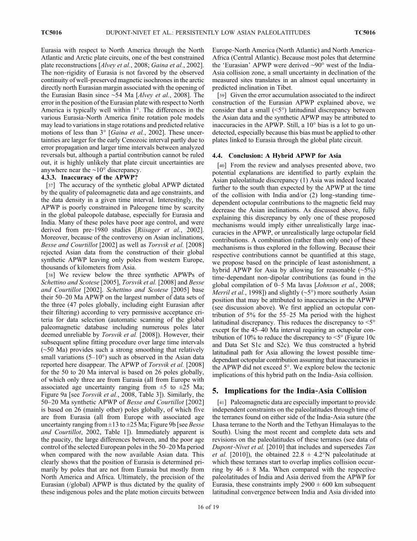
APWP and Asian poles, it has been previously proposed thatnon‐rigidity of Eurasia may explain the discrepancy betweenAsian and European paleomagnetic inclinations [Cognéet al., 1999; Hankard et al., 2007a]. To fully resolve theAsian inclination discrepancy presented here, this hypothesisrequires that central Asia rotated 12.5° southward withrespect to Europe (accommodating a total ∼1400 kmrespective latitudinal motion) between ∼60 and ∼40 Ma, andthen moved back northward since ∼40 Ma over a similarangular distance (Figure 10a). To accommodate thesemotions fully, it has been suggested that they can be dis-tributed in multiple Cenozoic reactivations of ancient strike‐slip zones such as the Tornquist‐Tesseyre line in Europe, andthe Ural mountain ranges [Cogné et al., 1999;Hankard et al.,2007a]. We find difficult to envisage that the requiredCenozoic motions would not have been noticed until now.For comparison, the extensive Gobi Altai and MongolianAltai mountain belts were probably produced by onlysome tens of kilometers of cumulative strike‐slip motion[Cunningham, 2005]. Eurasian non‐rigidity would alsorequire the plate circuit to be inaccurate.4.3.2. Inaccuracy of Plate Circuits?[36] Inaccuracies in plate circuits could allow (1) non‐
rigidity of Eurasia (unlikely, see above) or (2) repositioningthe entire Eurasian plate with respect to other plates [Gordon,1998]. Two studies have recently investigated the position of
Figure 10. Same as Figure 9 with addition of APWP forIndia and paleolatitudes provided by paleomagnetic resultsfrom Paleogene rocks of the Tethyan Himalaya and the Lhasaterranes found today on either side of the suture zone. Dashedline extrapolations indicate most likely locus of collisionbetween these terranes. (a) Assuming the full latitudinaldiscrepancy between the Asian average and the APWP forEurasia is associated to Asian latitudinal motion (unlikely,see text). (b) Assuming the full discrepancy is due to time‐dependant octopular field contribution (G3) to Asian dataoptimized to fit the APWP in 5 Myr windows (unlikely, seetext). (c) Hybrid latitudinal path for Asia optimized with thelowest possible time‐dependant octopular contribution as-suming that inaccuracies in the APWP did not exceed 5°.
DUPONT-NIVET ET AL.: PERSISTENTLY LOW ASIAN PALEOLATITUDES TC5016TC5016
15 of 19
Eurasia with respect to North America through the NorthAtlantic and Arctic plate circuits, one of the best constrainedplate reconstructions [Alvey et al., 2008; Gaina et al., 2002].The non‐rigidity of Eurasia is not favored by the observedcontinuity of well‐preservedmagnetic isochrones in the arcticdirectly north Eurasian margin associated with the opening ofthe Eurasian Basin since ∼54 Ma [Alvey et al., 2008]. Theerror in the position of the Eurasian plate with respect to NorthAmerica is typically well within 1°. The differences in thevarious Eurasia‐North America finite rotation pole modelsmay lead to variations in stage rotations and predicted relativemotions of less than 3° [Gaina et al., 2002]. These uncer-tainties are larger for the early Cenozoic interval partly due toerror propagation and larger time intervals between analyzedreversals but, although a partial contribution cannot be ruledout, it is highly unlikely that plate circuit uncertainties areanywhere near the ∼10° discrepancy.4.3.3. Inaccuracy of the APWP?[37] The accuracy of the synthetic global APWP dictated
by the quality of paleomagnetic data and age constraints, andthe data density in a given time interval. Interestingly, theAPWP is poorly constrained in Paleogene time by scarcityin the global paleopole database, especially for Eurasia andIndia. Many of these poles have poor age control, and werederived from pre‐1980 studies [Riisager et al., 2002].Moreover, because of the controversy on Asian inclinations,Besse and Courtillot [2002] as well as Torsvik et al. [2008]rejected Asian data from the construction of their globalsynthetic APWP leaving only poles from western Europe,thousands of kilometers from Asia.[38] We review below the three synthetic APWPs of
Schettino and Scotese [2005], Torsvik et al. [2008] and Besseand Courtillot [2002]. Schettino and Scotese [2005] basetheir 50–20 Ma APWP on the largest number of data sets ofthe three (47 poles globally, including eight Eurasian aftertheir filtering) according to very permissive acceptance cri-teria for data selection (automatic scanning of the globalpaleomagnetic database including numerous poles laterdeemed unreliable by Torsvik et al. [2008]). However, theirsubsequent spline fitting procedure over large time intervals(∼50 Ma) provides such a strong smoothing that relativelysmall variations (5–10°) such as observed in the Asian datareported here disappear. The APWP of Torsvik et al. [2008]for the 50 to 20 Ma interval is based on 26 poles globally,of which only three are from Eurasia (all from Europe withassociated age uncertainty ranging from ±5 to ±25 Ma;Figure 9a [see Torsvik et al., 2008, Table 3]). Similarly, the50–20 Ma synthetic APWP of Besse and Courtillot [2002]is based on 26 (mainly other) poles globally, of which fiveare from Eurasia (all from Europe with associated ageuncertainty ranging from ±13 to ±25Ma; Figure 9b [seeBesseand Courtillot, 2002, Table 1]). Immediately apparent isthe paucity, the large differences between, and the poor agecontrol of the selected European poles in the 50–20Ma periodwhen compared with the now available Asian data. Thisclearly shows that the position of Eurasia is determined pri-marily by poles that are not from Eurasia but mostly fromNorth America and Africa. Ultimately, the precision of theEurasian (/global) APWP is thus dictated by the quality ofthese indigenous poles and the plate motion circuits between
Europe‐North America (North Atlantic) and North America‐Africa (Central Atlantic). Because most poles that determinethe ‘Eurasian’ APWP were derived ∼90° west of the India‐Asia collision zone, a small uncertainty in declination of themeasured sites translates in an almost equal uncertainty inpredicted inclination in Tibet.[39] Given the error accumulation associated to the indirect
construction of the Eurasian APWP explained above, weconsider that a small (<5°) latitudinal discrepancy betweenthe Asian data and the synthetic APWP may be attributed toinaccuracies in the APWP. Still, a 10° bias is a lot to go un-detected, especially because this bias must be applied to otherplates linked to Eurasia through the global plate circuit.
4.4. Conclusion: A Hybrid APWP for Asia
[40] From the review and analyses presented above, twopotential explanations are identified to partly explain theAsian paleolatitude discrepancy (1) Asia was indeed locatedfurther to the south than expected by the APWP at the timeof the collision with India and/or (2) long‐standing time‐dependent octopular contributions to the magnetic field maydecrease the Asian inclinations. As discussed above, fullyexplaining this discrepancy by only one of these proposedmechanisms would imply either unrealistically large inac-curacies in the APWP, or unrealistically large octupolar fieldcontributions. A combination (rather than only one) of thesemechanisms is thus explored in the following. Because theirrespective contributions cannot be quantified at this stage,we propose based on the principle of least astonishment, ahybrid APWP for Asia by allowing for reasonable (∼5%)time‐dependant non‐dipolar contributions (as found in theglobal compilation of 0–5 Ma lavas [Johnson et al., 2008;Merril et al., 1998]) and slightly (∼5°) more southerly Asianposition that may be attributed to inaccuracies in the APWP(see discussion above). We first applied an octopular con-tribution of 5% for the 55–25 Ma period with the highestlatitudinal discrepancy. This reduces the discrepancy to <5°except for the 45–40 Ma interval requiring an octupolar con-tribution of 10% to reduce the discrepancy to <5° (Figure 10cand Data Set S1c and S2c). We thus constructed a hybridlatitudinal path for Asia allowing the lowest possible time‐dependant octopular contribution assuming that inaccuracies inthe APWP did not exceed 5°. We explore below the tectonicimplications of this hybrid path on the India‐Asia collision.
5. Implications for the India‐Asia Collision[41] Paleomagnetic data are especially important to provide
independent constraints on the paleolatitudes through time ofthe terranes found on either side of the India‐Asia suture (theLhasa terrane to the North and the Tethyan Himalayas to theSouth). Using the most recent and complete data sets andrevisions on the paleolatitudes of these terranes (see data ofDupont‐Nivet et al. [2010] that includes and supersedes Tanet al. [2010]), the obtained 22.8 ± 4.2°N paleolatitude atwhich these terranes start to overlap implies collision occur-ring by 46 ± 8 Ma. When compared with the respectivepaleolatitudes of India and Asia derived from the APWP forEurasia, these constraints imply 2900 ± 600 km subsequentlatitudinal convergence between India and Asia divided into
DUPONT-NIVET ET AL.: PERSISTENTLY LOW ASIAN PALEOLATITUDES TC5016TC5016
16 of 19

1100 ± 500 km within Asia and 1800 ± 700 km within India.However, we show here that the APWP is not consistent withAsian data sets. Using the hybrid path proposed aboveimplies lower latitudes for Asia (27.4 ± 7.1°N at 50Ma) in thehybrid path (Data Set S1c and Figure 10c) rather than 32.9 ±2.6°N for the APWP for Eurasia (Data Set S1a andFigure 10a). To estimate intra‐Asian convergence, this iscompared to the latitude of the Lhasa terrane at 54–47 Ma ofDupont‐Nivet et al. [2010] that is corrected from 22.8° ±4.2°N to 25.1 ± 4.2°N with the 5%G3 contribution accordingto our hybrid model (Figure 10c and Data Set S1c). In turn,this implies only 200 ± 900 km of latitudinal convergencenorth of the suture zone within Asia since 50 Ma. This is inmuch better agreement with documented deformation of thecollision zone accounting for no more than 200–300 km ofMiocene and younger N‐S shortening found essentially in theperiphery of the Tibetan Plateau in the Tien Shan, Qilian Shan‐Nan Shan andKunlun Shan [Avouac and Tapponnier, 1993;Métivier et al., 1999;Meyer et al., 1998; Ritts et al., 2008]. Inaddition, there is growing evidence for early deformationwithin the central and northern Tibetan Plateau that couldaccount for an additional 100–200 km of N–S shortening[Kapp et al., 2007, 2005]. Because the latitude of the Lhasaterrane is shifted slightly to theNorth due correction of the 5%G3 contribution, the age of the collision based on the overlapwith the Tethyan Himalaya latitude becomes slightly younger(Figure 10c) but not statistically different than previouslyestimated (46 ± 8 Ma) byDupont‐Nivet et al. [2010]. Finally,the total India‐Asia convergence and the post collisionalconvergence within India are difficult to assess in our hybridmodel because it is not clear how much of the Asian lowlatitude bias can be attributed to inaccuracy in the APWP or inthe plate circuit respectively (a maximum of ∼5° after the G3correction has been applied). It is important to realize herethat the relative convergence between Asia and India isdetermined through the plate circuit, and is independent ofpaleomagnetic poles obtained from these continents. There-fore, the India‐Asia convergence remains the same if the 5°bias is attributed only to inaccuracy in the APWP but willchange if the plate circuit is inaccurate. In effect, whenAli andAitchison [2006] propose a new pole for Eurasia to estimatethe age of the collision by comparing to the APWP for India,they infer that the plate circuit is inaccurate but not theAPWP. In contrast, assuming that the 5° bias in Asia is fullyfrom APWP inaccuracy implies that this 5° must also beapplied to India. In that case, the India‐Asia convergencewould remains the same but this would make the latitudinaldistance between India and the Tethyan Himalayas 5°(550 km) larger than the previously estimated 1800 ± 600 kmwhich can therefore be considered a minimum estimate. Thisis much larger than can be accounted for by crustal shorteningestimates along the Himalayan arc from Pakistan to Sikkimsumming up to a total ∼700 km minimum shortening in thefold‐thrust belt occurring mostly after 25–20 Ma [DeCelleset al., 2002; Long et al., 2010]. This has led previousresearchers to suggest that Greater India (between theTethyan Himalayas and India) may have consisted ofthinned continental [Acton, 1999] or even oceanic lithosphereallowing for lithosphere bypassing the subduction zone[Dupont‐Nivet et al., 2010]. Alternatively, the mismatch
between Indian convergence and Himalayan shortening hasled to proposals that the 50 Ma event is related to collision ofan island arc with Asia preceding a much younger (<35 Ma)India‐Asia collision, and that a large portion of oceanic crustbeing preserved north of Greater India at 50 Ma [Aitchisonet al., 2007]. Evidently, more paleomagnetic data north andsouth of the suture zone, notably from the Himalayas, arerequired to further test these hypotheses and reduce the errorbars on these estimates.
6. Conclusions[42] Asian paleolatitudes are consistently lower than pre-
dicted by Apparent Polar Wander Paths (APWPs). We pro-vide new paleomagnetic results from volcanic rocks fromMongolia, and sedimentary data sets fromChina corrected forinclination shallowing, which together with compiled reliableAsian data sets (including only results from volcanic rocksand inclination‐corrected sediments) confirm that Asianpaleolatitudes are 5–10° lower than predicted by the APWP inthe 50–20 Ma period. Two explanations are investigated: (1)Asian was indeed >1000 km further south than predicted bythe APWP (due to Eurasian non‐rigidity, inaccurate platecircuit for Eurasia, or inaccurate global APWP) or (2) largeand long‐standing time dependent octupolar contributions(up to 16%) to the geomagnetic field. We conclude thatneither option can realistically explain the observed inclina-tion anomaly. However, a combination of octupolar con-tributions and inaccuracies in the global APWP canreasonably have produced the observed latitudinal discrep-ancy taking the typical APWP uncertainties (<5°) and G3values (5%) into account. We therefore constructed a hybridpaleolatitudinal path for Asia, allowing the lowest possibletime‐dependant octopular contributions under the assump-tion that the APWP inaccuracy on Asian latitudinal motiondoes not exceed 5°. Reconstruction of the India‐Asia colli-sion according to this hybrid path, together with the selectedpaleomagnetic data from the collision zone imply Asianintracontinental shortening occurred since the collision inagreement with crustal shortening estimates.
7. Epilogue[43] In this paper, we illustrate how APWPs are used to
place very important quantitative constraints on amounts andrates of shortening accommodated in orogens, as well as toidentify ages of major tectonic events. These argumentseventually lie at the basis of spectacular geodynamic andtectonic processes, such as tectonic extrusion, the possibil-ity of many hundreds of kilometers of continental subduc-tion, and consumption of well over 1000 km of a continentaloverriding plate during ocean closure and continent‐continent collision. However, the synthetic APWP is basedon quite low amounts of data, for, in the last few decades,paleomagnetic research has mainly focused on resolvingmore detailed tectonic problems concerning rotations, orpaleopositions of small terranes incorporated in orogens, andmuch less on stable cratons, the position and motion of whichis assumed as well‐constrained. Therefore, APWPs arelargely based on old data sets, the age and paleomagnetic
DUPONT-NIVET ET AL.: PERSISTENTLY LOW ASIAN PALEOLATITUDES TC5016TC5016
17 of 19

analysis reported in which to an increasingly smaller degreedo no longer fit the standards we require today. As a result,sliding windows of 10, 20 or even 50 Ma are used, filteringout ‘details’ in plate motions. In this paper, we compileexisting and report new data for the early Cenozoic of Asiaand show that these strongly differ from the syntheticAPWPs. As we presented here, this difference has majorrepercussions for the Indo‐Asia collision, and thus also for thegeodynamic and tectonic scenarios that were developed here.The main conclusion we have to draw is that the existingsynthetic APWPs do not provide reliable quantitative con-straints on a ‘detailed’ time‐scale of 10 to 20 Ma, which is anessential timescale in the analysis of orogenic processes andassociated geodynamics. We therefore would like to interestthe paleomagnetic community to focus at least part of their
future efforts on the collection of high‐resolution, well‐datedpaleomagnetic data from the stable cratons, as identificationand further analysis of (here: tectonic) anomalies stronglyrelies on a reliable reference frame.
[44] Acknowledgments. This research was funded by the NetherlandOrganization for Scientific Research (NWO) to G.D.‐N. and D.J.J.v.H.,the UK NERC grant NER/D/S/2003/00671NERC to D.J.J.v.H., and NFRPetromaks grant to T.H.T. We thank Dickson W. Cunningham for discus-sions, Gijs Straathof for the precious help in the field and lab, and AhmetPeynircioğlu for drafting figures. We thank two anonymous and insightfulreviewers and Todd Ehlers (Editor) for their comments and suggestions.D.J.J.v.H. and T.H.T. acknowledge financial support of StatOil (SPlatesProject).
ReferencesActon, G. D. (1999), Apparent polar wander of India
since the Cretaceous with implications for regionaltectonics and true polar wander, in The IndianSubcontinent and Gondwana: A Palaeomagneticand Rock Magnetic Perspective, Memoir, vol. 44,edited by T. Radhakrishna and J. D. A. Piper,pp. 129–175, Geol. Soc. of India, Bangalore, India.
Aitchison, J. C., J. R. Ali, and A. M. Davis (2007),When and where did India and Asia collide?,J. Geophys. Res., 112, B05423, doi:10.1029/2006JB004706.
Aitchison, J. C., J. R. Ali, and A. M. Davis (2008),Reply to comment by Eduardo Garzanti on “Whenand where did India and Asia collide?,” J. Geophys.Res., 113, B04412, doi:10.1029/2007JB005431.
Ali, J. R., and J. C. Aitchison (2006), Positioning Paleo-gene Eurasia problem: Solution for 60–50 Ma andbroader tectonic implications, Earth Planet. Sci.Lett., 251, 148–155, doi:10.1016/j.epsl.2006.09.003.
Alvey, A., C. Gaina, N. J. Kusznir, and T. H. Torsvik(2008), Integrated crustal thickness mapping andplate reconstructions for the high Arctic, EarthPlanet. Sci. Lett., 274, 310–321, doi:10.1016/j.epsl.2008.07.036.
Avouac, J. P., and P. Tapponnier (1993), Kinematicmodel of active deformation in central Asia, Geo-phys. Res. Lett., 20(10), 895–898, doi:10.1029/93GL00128.
Barry, T. L., A. D. Saunders, P. D. Kempton, B. F.Windley, M. S. Pringle, D. Dorjnamjaa, and S.Saandar (2003), Petrogenesis ofCenozoic basalts fromMongolia: Evidence for the role of asthenosphericversus metasomatized lithospheric mantle sources,J. Petrol., 44, 55–91, doi:10.1093/petrology/44.1.55.
Bayasgalan, A., J. Jackson, J.‐F. Ritz, and S. Carretier(1999), Field examples of strike‐slip fault terminationsin Mongolia and their tectonic significance, Tectonics,18, 394–411, doi:10.1029/1999TC900007.
Bazhenov, M. L., and A. V. Mickolaichuck (2002),Paleomagnetism of Paleogene basalts from the TienShan, Kyrgyzstan: Rigid Eurasia and dipole geo-magnetic field, Earth Planet. Sci. Lett., 195, 155–166, doi:10.1016/S0012‐821X(01)00586‐6.
Besse, J., and V. Courtillot (2002), Apparent and truepolar wander and the geometry of the geomagneticfield in the last 200 Myr, J. Geophys. Res. ,107(B11), 2300, doi:10.1029/2000JB000050.
Biggin, A. J., D. J. J. van Hinsbergen, C. G. Langereis,G. B. Straathof, and M. H. L. Deenen (2008),Geomagnetic secular variation in the CretaceousNormal Superchron and in the Jurassic, Phys. EarthPlanet. Inter., 169, 3–19, doi:10.1016/j.pepi.2008.07.004.
Butler, R. F. (1992), Paleomagnetism: MagneticDomains to Geologic Terranes, 238 pp., BlackwellSci., Boston, Mass.
Chauvin, A., H. Perroud, and M. L. Bazhenov (1996),Anomalous low palaeomagnetic inclinations fromOligocene‐Lower Miocene red beds of the south–west Tien Shan, central Asia, Geophys. J. Int.,126, 303–313, doi:10.1111/j.1365‐246X.1996.tb05293.x.
Cogné, J. P., N. Halim, Y. Chen, and V. Courtillot(1999), Resolving the problem of shallow magneti-zations of Tertiary age in Asia: Insights from paleo-magnetic data from the Qiangtang, Kunlun, andQaidam blocks (Tibet, China), and a new hypothe-sis, J. Geophys. Res., 104(B8), 17,715–17,734,doi:10.1029/1999JB900153.
Copley, A., J.‐P. Avouac, and J.‐Y. Royer (2010), India‐Asia collision and the Cenozoic slowdown of theIndian plate: Implications for the forces drivingplate motions, J. Geophys. Res., 115, B03410,doi:10.1029/2009JB006634.
Cox, A., and R. B. Hart (1986), Plate Tectonics: How ItWorks, Blackwell Sci., Palo Alto, Calif.
Cunningham, W. D. (2005), Active intracontinentaltranspressional mountain building in the MongolianAltai: Defining a new class of orogen, Earth Planet.Sci. Lett., 240, 436–444, doi:10.1016/j.epsl.2005.09.013.
Cunningham, W. D. (2007), Structural and topographiccharacteristics of restraining bend mountain rangesof the Altai, Gobi Altai and easternmost Tien Shan,in Tectonics of Strike‐Slip Restraining and ReleasingBends, edited by W. D. Cunningham and P. Mann,Geol. Soc. Spec. Publ., 290, 219–237.
Cunningham, W. D., B. F. Windley, D. Dornjnamjaa,D. Badamgarav, and M. Saander (1996), Late Ceno-zoic transpression in southwestern Mongolia and theGobi‐Altai–Tien Shan connection, Earth Planet. Sci.Lett., 140, 67–81, doi:10.1016/0012‐821X(96)00048‐9.
Cunningham, W. D., B. F. Windley, L. A. Owen,T. Barry, D. Dornjnamjaa, and J. Badamgarav(1997), Geometry and style of partitioned deforma-tion within a late Cenozoic transpressional zone inthe eastern Gobi Altai Mountains, Mongolia, Tecto-nophysics, 277, 285–306, doi:10.1016/S0040‐1951(97)00034‐6.
Dai, S., X. Fang, G. Dupont‐Nivet, C. Song, J. Gao,W. Krijgsman, C. Langereis, and W. Zhang (2006),Magnetostratigraphy of Cenozoic sediments fromthe Xining Basin: Tectonic implications for thenortheastern Tibetan Plateau, J. Geophys. Res.,111, B11102, doi:10.1029/2005JB004187.
Dankers, P. H. M., and J. D. A. Zijderveld (1981),Alternating field demagnetization of rocks, and theproblem of gyromagnetic remanence, Earth Planet.Sci. Lett., 53, 89–92, doi:10.1016/0012‐821X(81)90029‐7.
DeCelles, P. G., D. M. Robinson, and G. Zandt (2002),Implications of shortening in the Himalayan fold‐
thrust belt for uplift of the Tibetan Plateau, Tecton-ics, 21(6), 1062, doi:10.1029/2001TC001322.
Devyatkin, Y. V., and S. B. Smelov (1980), Position ofbasalts in the Cenozoic sedimentary sequence ofMongolia, Int. Geol. Rev. , 22(3), 307–317,doi:10.1080/00206818209466888.
Dunlop, D., and Ö. Özdemir (1997), Rock Magnetism:Fundamentals and Frontiers, 573 pp., doi:10.1017/CBO9780511612794, Cambridge Univ. Press,Cambridge, U. K.
Dupont‐Nivet, G., Z. Guo, R. F. Butler, and C. Jia(2002), Discordant paleomagnetic direction inMiocene rocks from the central Tarim Basin: Evi-dence for local deformation and inclination shallow-ing, Earth Planet. Sci. Lett., 199, 473–482,doi:10.1016/S0012‐821X(02)00566‐6.
Dupont‐Nivet, G., W. Krijgsman, C. G. Langereis,H. A. Abels, S. Dai, and X. Fang (2007), Tibetanplateau aridification linked to global coolingat the Eocene‐Oligocene transition, Nature, 445,635–638, doi:10.1038/nature05516.
Dupont‐Nivet, G., S. Dai, X. Fang, W. Krijgsman,V. Erens, M. Reitsma, and C. Langereis (2008),Timing and distribution of tectonic rotations in thenortheastern Tibetan Plateau, in Investigations Intothe Tectonics of the Tibetan Plateau, edited byB. C. Burchfiel and E. Wang, Spec. Pap. Geol.Soc. Am., 444, 73–87.
Dupont‐Nivet, G., P. C. Lippert, D. J. J. van Hinsbergen,M. J. M. Meijers, and P. Kapp (2010), Palaeolatitudeand age of the Indo‐Asia collision: Palaeomagneticconstraints, Geophys. J. Int., 182, 1189–1198,doi:10.1111/j.1365‐246X.2010.04697.x.
Fisher, R. A. (1953), Dispersion on a sphere, Proc. R.Soc. London, Ser. A, 217, 295–305, doi:10.1098/rspa.1953.0064.
Gaina, C., W. R. Roest, and R. D. Müller (2002), LateCretaceous‐Cenozoic deformation of northeastAsia, Earth Planet. Sci. Lett., 197, 273–286,doi:10.1016/S0012‐821X(02)00499‐5.
Garzanti, E. (2008), Comment on “When and where didIndia and Asia collide?” by Jonathan C. Aitchison,Jason R. Ali, and Aileen M. Davis, J. Geophys.Res., 113, B04411, doi:10.1029/2007JB005276.
Gilder, S., Y. Chen, and S. Sen (2001), Oligo‐Miocenemagnetostratigraphy and rock magnetism of theXishuigou section, Subei (Gansu Province, westernChina) and implications for shallow inclinations incentral Asia, J. Geophys. Res., 106(B12), 30,505–30,521, doi:10.1029/2001JB000325.
Gilder, S., Y. Chen, J.‐P. Cogné, X. Tan, V. Courtillot,D. Sun, and Y. Li (2003), Paleomagnetism of UpperJurassic to Lower Cretaceous volcanic and sedimen-tary rocks from the western Tarim Basin and impli-cations for inclination shallowing and absolutedating of the M‐0 (ISEA?) chron, Earth Planet.Sci. Lett., 206, 587–600, doi:10.1016/S0012‐821X(02)01074‐9.
DUPONT-NIVET ET AL.: PERSISTENTLY LOW ASIAN PALEOLATITUDES TC5016TC5016
18 of 19

Gordon, R. G. (1998), The plate tectonic approxima-tion: Plate nonrigidity, diffuse plate boundaries,and global plate reconstructions, Annu. Rev. EarthPlanet. Sci., 26(1), 615–642, doi:10.1146/annurev.earth.26.1.615.
Hankard, F., J.‐P. Cogné, and V. Kravchinsky (2005),A new Late Cretaceous paleomagnetic pole for thewest of Amuria block (Khurmen Uul, Mongolia),Ear t h P lane t . S c i . Le t t . , 236 , 3 59–373 ,doi:10.1016/j.epsl.2005.05.033.
Hankard, F., J.‐P.Cogné,V.A.Kravchinsky, L. Carporzen,A. Bayasgalan, and P. Lkhagvadorj (2007a), NewTertiary paleomagnetic poles from Mongoliaand Siberia at 40, 30, 20, and 13 Ma: Clues onthe inclination shallowing problem in central Asia,J. Geophys. Res., 112, B02101, doi:10.1029/2006JB004488.
Hankard, F., J.‐P. Cogné, X. Quidelleur, A. Bayasgalan,and P. Lkhagvadorj (2007b), Paleomagnetism andK‐Ar dating of Cretaceous basalts from Mongolia,Geophys. J. Int., 169, 898–908, doi:10.1111/j.1365‐246X.2007.03292.x.
Hankard, F., J.‐P. Cogné, F. Lagroix, X. Quidelleur,V.A.Kravchinksy, A. Bayasgalan, and P. Lkhagvadorj(2008), Palaeomagnetic results from Palaeocene basaltsfrom Mongolia reveal no inclination shallowing at60 Ma in central Asia, Geophys. J. Int., 172, 87–102,doi:10.1111/j.1365‐246X.2007.03619.x.
Höck, V., G. Daxner‐Höck, H. P. Schmid, D.Badamgarav, W. Frank, G. Furtmüller, O. Montag,R. Barsbold, Y. Khand, and J. Sodov (1997),Oligocene‐Miocene sediments, fossils and basaltsfrom the Valley of Lakes (central Mongolia)—An integrated study, Mitt. Oesterr. Geol. Ge., 90,83–125.
Huang, B., J. D. A. Piper, Y. Wang, H. He, and R. Zhu(2005), Paleomagnetic and geochronologicalconstraints on the post‐collisional northward con-vergence of the southwest Tian Shan, NW China,Tectonophysics, 409, 107–124, doi:10.1016/j.tecto.2005.08.018.
Johnson, C. L., et al. (2008), Recent investigations ofthe 0–5 Ma geomagnetic field recorded by lavaflows, Geochem. Geophys. Geosyst., 9, Q04032,doi:10.1029/2007GC001696.
Jolivet, M., et al. (2007), Mongolian summits:An uplifted, flat, but still preserved erosion surface,Geology , 35 (10 ) , 871–874 , do i :10 .1130 /G23758A.1.
Kapp, P., A. Yin, T. M. Harrison, and L. Ding (2005),Cretaceous‐Tertiary shortening, basin development,and volcanism in central Tibet, Geol. Soc. Am.Bull., 117, 865–878, doi:10.1130/B25595.1.
Kapp, P., P. G. DeCelles, A. L. Leier, J. M. Fabijanic,S. He, A. Pullen, G. E. Gehrels, and L. Ding(2007), The Gangdese retroarc thrust belt revealed,GSA Today, 17, 4–9, doi:10.1130/GSAT01707A.1.
Kirschvink, J. L. (1980), The least squares lineand plane and the analysis of paleomagnetic data,Geophys. J. R. Astron. Soc., 62, 699–718.
Long, S. P., N. McQuarrie, T. Tobgay, and D. Grujic(2010), Geometry and crustal shortening of theHimalayan fold‐thrust belt, eastern and centralBhutan, Geol. Soc. Am. Bull., in press.
McFadden, P. L., and F. J. Lowes (1981), The discrim-ination of mean directions drawn from Fisher distri-butions, Geophys. J. R. Astron Soc., 67, 19–33.
McFadden, P. L., and M. W. McElhinny (1988), Thecombined analysis of remagnetization circles anddirect observations in palaeomagnetism, EarthPlanet. Sci. Lett., 87, 161–172, doi:10.1016/0012‐821X(88)90072‐6.
Merril, R. T., M. W. McElhinny, and P. L. McFadden(1998), The Magnetic Field of the Earth, Int. Geo-phys. Ser., vol. 63, Academic, London.
Métivier, F., Y. Gaudemer, P. Tapponnier, and M. Klein(1999), Mass accumulation rates in Asia during
the Cenozoic, Geophys. J. Int., 137, 280–318,doi:10.1046/j.1365‐246X.1999.00802.x.
Meyer, B., P. Tapponnier, L. Bourjot, F. Metivier,Y. Gaudemer, G. Peltzer, G. Shummin, and C. Zhitai(1998), Crustal thickening in the Gansu‐Qinghai,lithospheric mantle, oblique and strike‐slip con-trolled growth of the Tibetan Plateau, Geophys. J.Int., 135, 1–47, doi:10.1046/j.1365‐246X.1998.00567.x.
Molnar, P., and J. M. Stock (2009), Slowing of India’sconvergence with Eurasia since 20 Ma and itsimplications for Tibetan mantle dynamics, Tectonics,28, TC3001, doi:10.1029/2008TC002271.
Moreau, M.‐G., J. Besse, F. Fluteau, and M. Greff‐Lefftz (2007), A new global Paleocene‐Eoceneapparent polar wandering path loop by “stacking”magnetostratigraphies: Correlations with highlatitude climatic data, Earth Planet. Sci. Lett., 260,152–165, doi:10.1016/j.epsl.2007.05.025.
Patzelt, A., H. Li, J. Wang, and E. Appel (1996),Palaeomagnetism of Cretaceous to Tertiary sedi-ments from southern Tibet: Evidence for the extentof the northern margin of India prior to the collisionwith Eurasia, Tectonophysics, 259, 259–284.
Riisager, P., J. Riisager, N. Abrahamsen, and R. Waagstein(2002), New paleomagnetic pole and magnetostrati-graphy of Faroe Islands flood volcanics, NorthAtlan-tic igneous province, Earth Planet. Sci. Lett., 201,261–276, doi:10.1016/S0012‐821X(02)00720‐3.
Ritts, B. D., Y. Yue, S. A. Graham, E. R. Sobel, O. A.Abbink, and D. Stockli (2008), From sea level tohigh elevation in 15 million years: Uplift historyof the northern Tibetan Plateau margin in the AltunShan, Am. J. Sci., 308(5), 657–678, doi:10.2475/05.2008.01.
Ruddiman, W. F., J. E. Kutzbach, and I. C. Prentice(1997), Testing climatic effects of orography andCO2 with general circulation and biome models,in Tectonic Uplift and Climate Change, edited byW. F. Ruddiman, pp. 203–235, Plenum, New York.
Schettino, A., and C. R. Scotese (2005), Apparent polarwander paths for the major continents (200 Ma tothe present day): A palaeomagnetic reference framefor global tectonic reconstructions, Geophys. J. Int.,163, 727–759, doi:10.1111/j.1365‐246X.2005.02638.x.
Si, J., and R. Van der Voo (2001), Too‐low magneticinclinations in central Asia: An indication of along‐term Tertiary non‐dipole field?, Terra Nova,13(6), 471–478, doi:10.1046/j.1365‐3121.2001.00383.x.
Tan, X., K. P. Kodama, H. Chen, D. Fang, D. Sun, andY. Li (2003), Paleomagnetism and magnetic anisot-ropy of Cretaceous red beds from the Tarim basin,northwest China: Evidence for a rock magneticcause of anomalously shallow paleomagnetic incli-nations from central Asia, J. Geophys. Res.,108(B2), 2107, doi:10.1029/2001JB001608.
Tan, X., S. Gilder, K. P. Kodama, W. Jiang, Y. Han,H. Zhang, H. Xu, and D. Zhou (2010), New paleo-magnetic results from the Lhasa block: Revisedestimation of latitudinal shortening across Tibetand implications for dating the India‐Asia collision,Earth Planet. Sci. Lett., 293, 396–404.
Tapponnier, P., Z. Xu, F. Roger, B. Meyer, N. Arnaud,G. Wittlinger, and J. Yang (2001), Oblique stepwiserise and growth of the Tibetan Plateau, Science,294, 1671–1677, doi:10.1126/science.105978.
Tauxe, L. (2005), Inclination flattening and the geocen-tric axial dipole hypothesis, Earth Planet. Sci. Lett.,233, 247–261, doi:10.1016/j.epsl.2005.01.027.
Tauxe, L., and D. V. Kent (2004), A simplified statisti-cal model for the geomagnetic field and the detec-tion of shallow bias in paleomagnetic inclinations:Was the ancient magnetic field dipolar?, in Time-scales of the Paleomagnetic Field, Geophys.Monogr. Ser., vol. 145, edited by J. E. T. Channellet al., pp. 101–115, AGU, Washington, D. C.
Torsvik, T. H., and R. Van der Voo (2002), RefiningGondwana and Pangea Palaeogeography: Estimatesof Phanerozoic non‐dipole (octupole) fields,Geophys. J. Int., 151, 771–794, doi:10.1046/j.1365‐246X.2002.01799.x.
Torsvik, T. H., J. Mosar, and E. A. Eide (2001),Cretaceous‐Tertiary geodynamics: A North Atlanticexercise , Geophys. J . Int . , 146 , 850–866,doi:10.1046/j.0956‐540x.2001.01511.x.
Torsvik, T. H., R. Van der Voo, and T. F. Redfield(2002), Frontier—Relative hotspot motions versustrue polar wander, Earth Planet. Sci. Lett., 202,185–200, doi:10.1016/S0012‐821X(02)00807‐5.
Torsvik, T. H., R. D. Müller, R. Van der Voo,B. Steinberger, and C. Gaina (2008), Global platemotion frames: Toward a unified model, Rev. Geo-phys., 46, RG3004, doi:10.1029/2007RG000227.
Vandamme, D. (1994), A new method to determinepaleosecular variation, Phys. Earth Planet. Inter.,85, 131–142, doi:10.1016/0031‐9201(94)90012‐4.
Van der Voo, R. (1990), The reliability of paleomagnet-ic data, Tectonophysics, 184, 1–9, doi:10.1016/0040‐1951(90)90116‐P.
Van der Voo, R., and T. H. Torsvik (2001), Evidencefor late Paleozoic and Mesozoic non‐dipole fieldsprovides an explanation for the Pangea reconstruc-tion problems, Earth Planet. Sci. Lett., 187, 71–81,doi:10.1016/S0012‐821X(01)00285‐0.
Van der Voo, R., W. Spakman, and H. Bijwaard (1999),Mesozoic subducted slabs under Siberia, Nature,397, 246–249, doi:10.1038/16686.
van Hinsbergen, D. J. J., G. B. Straathof, K. F. Kuiper,W. D. Cunningham, and J. R. Wijbrans (2008), Norotations during transpressional orogeny in the GobiAltai: Coinciding Mongolian and Eurasian apparentpolar wander paths, Geophys. J. Int., 173, 105–126,doi:10.1111/j.1365‐246X.2007.03712.x.
Vassallo, R.,M. Jolivet, J.‐F.Ritz, R.Braucher, C. Larroque,C. Sue, M. Todbileg, and D. Javkhlanbold (2007),Uplift age and rates of the Gurvan Bogd system(Gobi‐Altay) by apatite fission track analysis, EarthPlanet. Sci. Lett., 259, 333–346, doi:10.1016/j.epsl.2007.04.047.
Wang, X., B. Wang, Z. Qiu, G. Xie, J. Xie, W. Downs,Z. Qiu, and T. Deng (2003), Danghe area (westernGansu, China) biostratigraphy and implications fordepositional history and tectonics of northern TibetanPlateau, Earth Planet. Sci. Lett., 208, 253–269,doi:10.1016/S0012‐821X(03)00047‐5.
Whitford‐Stark, J. L. (1987), A Survey of CenozoicVolcanism on Mainland Asia, 74 pp., Geol. Soc.of Am., Boulder, Colo.
Yan, M., R. Van der Voo, X. Fang, J. M. Parés, andD. K. Rea (2006), Paleomagnetic evidence for amid‐Miocene clockwise rotation of about 25° ofthe Guide Basin area in NE Tibet, Earth Planet.Sci. Lett., 241, 234–247, doi:10.1016/j.epsl.2005.10.013.
Yin, A., et al. (2002), Tectonic history of the AltynTagh fault system in northern Tibet inferred fromCenozoic sedimentation, Geol. Soc. Am. Bull.,114, 1257–1295, doi:10.1130/0016‐7606(2002)114<1257:THOTAT>2.0.CO;2.
Zijderveld, J. D. A. (1967), A. C. demagnetization ofrocks: Analysis of results, in Methods in Palaeo-magnetism, edited by D. W. Collinson, K. M. Creer,and S. K. Runcorn, pp. 254–286, Elsevier,Amsterdam.
G. Dupont‐Nivet, Paleomagnetic Laboratory “FortHoofddijk ,” Facul ty of Geosciences , UtrechtUniversity, Budapestlaan 17, NL‐3584 CD Utrecht,Netherlands. ([email protected])
T. H. Torsvik and D. J. J. van Hinsbergen, Physics ofGeological Processes, University of Oslo, Sem Sælandsvei 24, N‐0316 Oslo, Norway. ([email protected])
DUPONT-NIVET ET AL.: PERSISTENTLY LOW ASIAN PALEOLATITUDES TC5016TC5016
19 of 19