permitted materials - ridesmart.com · web view2.recreational area is defined as the common area...
TRANSCRIPT
2015 Development Code
PDB 1. Section 4.125. V – Village Zone
(.01) Purpose.The Village (V) zone is applied to lands within the Residential Village Comprehensive Plan Map designation. The Village zone is the principal implementing tool for the Residential Village Comprehensive Plan designation. It is applied in accordance with the Villebois Village Master Plan and the Residential Village Comprehensive Plan Map designation as described in the Comprehensive Plan.
A. The Village zone provides for a range of intensive land uses and assures the most efficient use of land.
B. The Village zone is intended to assure the development of bicycle and pedestrian-sensitive, yet auto-accommodating, communities containing a range of residential housing types and densities, mixed-use buildings, commercial uses in the Village Center and Neighborhood Centers, and employment opportunities.
C. The Village zone, together with the Architectural Pattern Book and Community Elements Book, is intended to provide quantitative and objective review guidelines.
(.02) Permitted Uses. Examples of principle uses that are typically permitted:
A. Single Family Dwellings
B. Accessory Dwelling Units, subject to the standards of Section 4.113 (.11)
C. Duplexes
D. Row Houses
E. Multi-Family Dwellings
F. Cluster Housing
G. Residential Facilities, Residential Homes, and Community Housing developed to implement ORS 426.508
H. Non-commercial parks, plazas, playgrounds, recreational facilities, community buildings and grounds, tennis courts, and other similar recreational and community uses owned and operated either publicly or by an owners association.
I. Commercial uses within the Village Center, subject to the standards of (.06) Standards Applying to Commercial Uses and similar to the following:1. Sales and servicing of consumer goods:
Bicycle shopBookstoreClothing storeElectronics and appliances storeFloristFurniture store
CHAPTER 4 - PLANNING AND LAND DEVELOPMENT PAGE B – 1.ZONING UPDATED JULY 2013
Error! No text of specified style in document.
JewelerPet shop
2. Food and sundries:BakeryButcher shopConvenience storeDelicatessenDrugstoreGifts StoreHardware store
3. Lifestyle and recreation:Art galleryBarbershop or hair salonBoutique shops and other specialty retailCoffee shops including outdoor eating areasHealth club or gymnasiumRestaurants and pubs including outdoor eating areasDance or martial arts studio
4. Service Commercial:Banking and investment servicesChild day careCustom tailoringDry cleanersPhoto processingPostal serviceReproduction servicesLaundromatLocksmithTelecommunications servicesUpholstery shop
5. General Office:Computer and technology companiesGovernmental servicesHealth servicesInsurance agenciesNonprofit organizationsProfessional-type servicesReal estate officesSecretarial servicesTravel agencies
J. Commercial uses within a Neighborhood Center, subject to the standards of (.06) Standards Applying to Commercial Uses, and similar to the following:
CHAPTER 4 - PLANNING AND LAND DEVELOPMENT PAGE B – 2.ZONING UPDATED JULY 2013
Error! No text of specified style in document.
BakeryBarbershop and/or hair salonBookstoreCoffee shop including outdoor eating areasConvenience storeDry cleanersFloristNewsstandPostal servicesService oriented officesWine bar
K. Group Living Facility
(.03) Permitted Accessory Uses
A. Uses, buildings and structures customarily incidental to any of the principal permitted uses and located on the same lot
B. Home Occupations
C. Structured parking, garages, and parking areas
D. Temporary Uses per Section 4.163.
E. Signs subject to the standards of (.12) Signage and Wayfinding.
F. Temporary buildings for uses incidental to construction work, which buildings shall be removed immediately upon completion or abandonment of the construction work. In no case shall such buildings remain on the premises longer than ten (10) days after the receipt of a Certificate of Occupancy or the expiration of construction permits.
(.04) Conditional Uses Applications for the following conditional uses shall be processed in accordance with the procedures listed in Section 4.512:
A. Public and semi-public buildings and/or structures essential to the physical and economic welfare of an area, such as fire stations, utility sub-stations and pump stations
B. Public or private clubs, lodges or meeting halls
C. Public or private libraries and museums
D. Religious institutions.
E. Transit Stations
F. Community Centers
G. Conference Centers
CHAPTER 4 - PLANNING AND LAND DEVELOPMENT PAGE B – 3.ZONING UPDATED JULY 2013
Error! No text of specified style in document.
H. Non-commercial community buildings and grounds, and other similar community uses, owned and operated either publicly or by an owners association.
I. Commercial parks, plazas, playgrounds, recreational facilities, community buildings and grounds, tennis courts, and other similar recreational and community uses owned and operated privately.
J. Schools (public, private, or commercial)
K. Theaters
L. Home Business
M. Commercial Parking Facility
N. Light Manufacturing / Research and Development located within the Village Center.
O. Overnight Lodging Facility
P. Grocery Store or Specialty Grocery Store
(.05) Development Standards Applying to All Developments in the Village Zone. In addition to other applicable provisions of the Wilsonville Planning and Land Development Ordinance, all development in the Village zone shall be subject to Tables V-1 through V-4, and to the following. If there is a conflict between the provisions of the Village zone and other portions of the Code, then the provisions of this section shall apply.
A. Block, Alley, Pedestrian and Bicycle Standards:1. Maximum Block Perimeter: 1,800 feet, unless the Development Review
Board makes a finding that barriers such as existing buildings, topographic variations, or designated Significant Resource Overlay Zone areas will prevent a block perimeter from meeting this standard.
2. Maximum spacing between streets or private drive for local access: 530 feet, unless the Development Review Board makes a finding that barriers such as existing buildings, topographic variations, or designated Significant Resource Overlay Zone areas will prevent street extensions from meeting this standard. Under such circumstances, intervening pedestrian and bicycle access shall be provided, with a maximum spacing of 330 feet from those local streets or private drives, unless the Development Review Board makes a finding that barriers such as existing buildings, topographic variations, or designated Significant Resource Overlay Zone areas will prevent pedestrian and bicycle facility extensions from meeting this standard. [Amended by Ord. 682, 9/9/10]
B. Access: All lots with access to a public street, and an alley, shall take vehicular access from the alley to a garage or parking area, except as determined by the City Engineer.
CHAPTER 4 - PLANNING AND LAND DEVELOPMENT PAGE B – 4.ZONING UPDATED JULY 2013
Error! No text of specified style in document.
C. Trailers, travel trailers, mobile coaches, or any altered variation thereof shall not be used for the purpose of conducting a trade or calling, or for storage of material, unless approved for such purpose as a temporary use.
D. Fences:1. General Provisions:
a. Fencing in the Village Zone shall be in compliance with the Master Fencing Program in the adopted Architectural Pattern Book for the appropriate SAP. [Section 4.125(.09)(D)(1)(a) amended by Ord. No. 596, 10/3/05.]
b. When two or more properties with different setbacks abut, the property with the largest front yard setback requirement shall be used to determine the length and height of the shared side yard fence, as required by Section 4.125(.05)(D)(1)(a), above.Example: Building ‘A’ has 20’ front yard setback and Building ‘B’ has zero front yard setback. Since Building ‘A’ has the larger front yard setback, it shall be used to determine the height and length of the shared side yard fence. It is 6’ tall, but is reduced to 3’ in front of Building ‘A’s building line.
c. The Development Review Board may, in their discretion, require such fencing as deemed necessary to promote and provide traffic safety, noise mitigation, and nuisance abatement, and the compatibility of different uses permitted on adjacent lots of the same zone and on adjacent lots of different zones.
2. Residential:a. The maximum height of any fence located in the required front yard of a
residential development shall not exceed three (3) feet.b. Fences on residential lots shall not include chain link, barbed wire, razor
wire, electrically charged wire, or be constructed of sheathing material such as plywood or flake board. Fences in residential areas that protect wetlands, or other sensitive areas, may be chain link.
E. Recreational Area in Multi-family Residential and Mixed Use Developments 1. The Recreational Area requirement is intended to provide adequate recreational amenities for occupants of multiple family developments and mixed use developments where the majority of the developed square footage is to be in residential use. 2. Recreational Area is defined as the common area of all lawns, community gardens, play lots, plazas, court yards, interior and exterior swimming pools, ball courts, tennis courts, exercise rooms, health and exercise facilities, libraries, internet/electronic media rooms, decks and other similar areas for common recreational uses. Recreational Area may include Parks required under the Villebois Village Master Plan, and any usable park areas not shown
CHAPTER 4 - PLANNING AND LAND DEVELOPMENT PAGE B – 5.ZONING UPDATED JULY 2013
Error! No text of specified style in document.
in such plan. Private areas under this definition, defined as those areas that are accessible only by a single owner or tenant, or commercial or retail recreation facilities serving the general public, shall not constitute or contribute to the measurement of Recreational Area.3. A variety of age appropriate facilities shall be included in the mix of Recreational Area facilities. 4. Recreational Area shall be calculated at the following ratios:a. At the SAP Level – 195 square feet per residential unit.b. At the PDP level – an additional 30 square feet per residential unit
3. Outdoor Living Area shall be considered to be part of the Open Space requirement in Section 4.125(.08). [Section 4.125(.05)(E.) amended by Ord. 606, 4/3/06.]
F. Fire Protection:1. All structures shall include a rated fire suppression system (i.e., sprinklers), as
approved by the Fire Marshal.
CHAPTER 4 - PLANNING AND LAND DEVELOPMENT PAGE B – 6.ZONING UPDATED JULY 2013
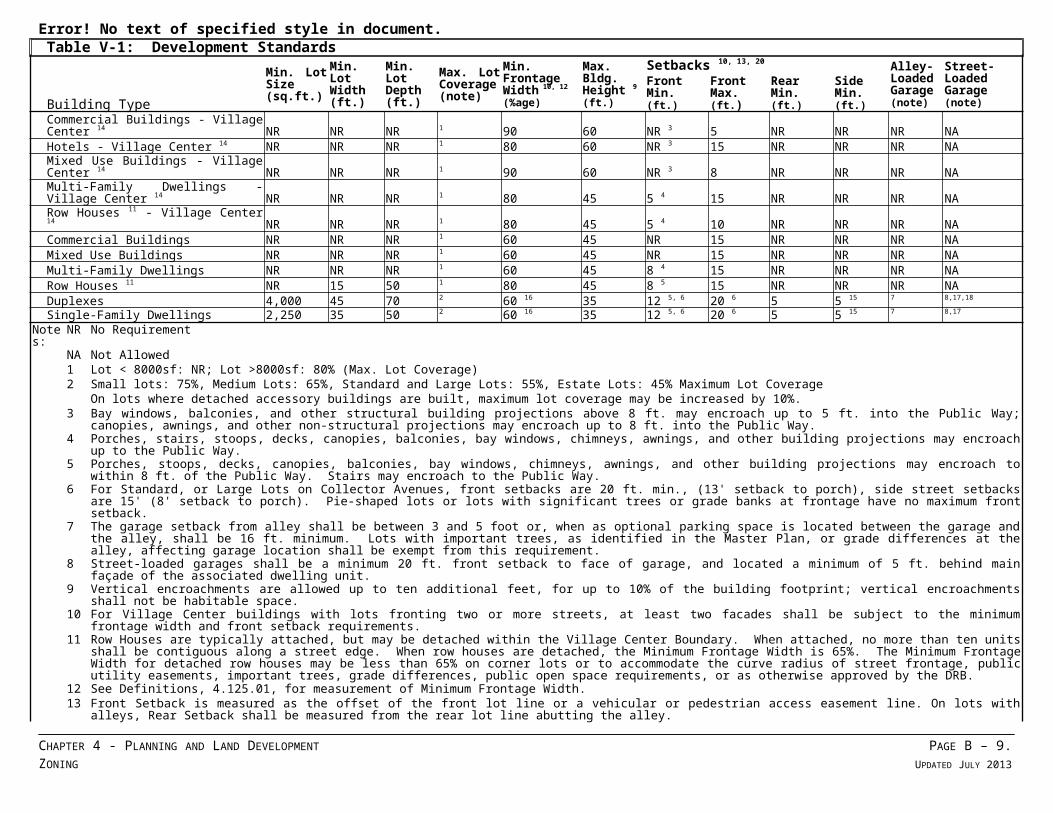
Error! No text of specified style in document.Table V-1: Development Standards
Building Type
Min. Lot Size(sq.ft.)
Min. Lot Width(ft.)
Min. Lot Depth(ft.)
Max. Lot Coverage(note)
Min. Frontage Width 10, 12
(%age)
Max. Bldg. Height 9
(ft.)
Setbacks 10, 13, 20 Alley-Loaded Garage(note)
Street-Loaded Garage(note)
Front Min. (ft.)
Front Max. (ft.)
RearMin. (ft.)
Side Min.(ft.)
Commercial Buildings - Village Center 14 NR NR NR 1 90 60 NR 3 5 NR NR NR NAHotels - Village Center 14 NR NR NR 1 80 60 NR 3 15 NR NR NR NAMixed Use Buildings - Village Center 14 NR NR NR 1 90 60 NR 3 8 NR NR NR NAMulti-Family Dwellings - Village Center 14 NR NR NR 1 80 45 5 4 15 NR NR NR NARow Houses 11 - Village Center 14 NR NR NR 1 80 45 5 4 10 NR NR NR NACommercial Buildings NR NR NR 1 60 45 NR 15 NR NR NR NAMixed Use Buildings NR NR NR 1 60 45 NR 15 NR NR NR NAMulti-Family Dwellings NR NR NR 1 60 45 8 4 15 NR NR NR NARow Houses 11 NR 15 50 1 80 45 8 5 15 NR NR NR NADuplexes 4,000 45 70 2 60 16 35 12 5, 6 20 6 5 5 15 7 8,17,18
Single-Family Dwellings 2,250 35 50 2 60 16 35 12 5, 6 20 6 5 5 15 7 8,17
Notes:
NR No Requirement
NA Not Allowed1 Lot < 8000sf: NR; Lot >8000sf: 80% (Max. Lot Coverage)2 Small lots: 75%, Medium Lots: 65%, Standard and Large Lots: 55%, Estate Lots: 45% Maximum Lot Coverage
On lots where detached accessory buildings are built, maximum lot coverage may be increased by 10%.3 Bay windows, balconies, and other structural building projections above 8 ft. may encroach up to 5 ft. into the Public Way; canopies, awnings, and other non-structural projections may
encroach up to 8 ft. into the Public Way.4 Porches, stairs, stoops, decks, canopies, balconies, bay windows, chimneys, awnings, and other building projections may encroach up to the Public Way.5 Porches, stoops, decks, canopies, balconies, bay windows, chimneys, awnings, and other building projections may encroach to within 8 ft. of the Public Way. Stairs may encroach to the Public
Way.6 For Standard, or Large Lots on Collector Avenues, front setbacks are 20 ft. min., (13' setback to porch), side street setbacks are 15' (8' setback to porch). Pie-shaped lots or lots with significant
trees or grade banks at frontage have no maximum front setback.7 The garage setback from alley shall be between 3 and 5 foot or, when as optional parking space is located between the garage and the alley, shall be 16 ft. minimum. Lots with important
trees, as identified in the Master Plan, or grade differences at the alley, affecting garage location shall be exempt from this requirement.8 Street-loaded garages shall be a minimum 20 ft. front setback to face of garage, and located a minimum of 5 ft. behind main façade of the associated dwelling unit.9 Vertical encroachments are allowed up to ten additional feet, for up to 10% of the building footprint; vertical encroachments shall not be habitable space.10 For Village Center buildings with lots fronting two or more streets, at least two facades shall be subject to the minimum frontage width and front setback requirements.11 Row Houses are typically attached, but may be detached within the Village Center Boundary. When attached, no more than ten units shall be contiguous along a street edge. When row
houses are detached, the Minimum Frontage Width is 65%. The Minimum Frontage Width for detached row houses may be less than 65% on corner lots or to accommodate the curve radius of street frontage, public utility easements, important trees, grade differences, public open space requirements, or as otherwise approved by the DRB.
12 See Definitions, 4.125.01, for measurement of Minimum Frontage Width.13 Front Setback is measured as the offset of the front lot line or a vehicular or pedestrian access easement line. On lots with alleys, Rear Setback shall be measured from the rear lot line abutting
the alley.14 See Figure 2A - Village Center Boundary & Land Use Plan in the Villebois Village Master Plan for areas included within the Village Center.15 On Estate Lots and Large Lots with frontage 70 ft. or wider, the minimum combined side yard setbacks shall total 15 ft. with a minimum of 5 ft. On Small and Medium Lots, minimum side
setback shall be 0 ft. or as required by Building Code.16 For cluster housing with lots arranged on a courtyard, frontage shall be measured at the front door face of the building adjacent to a public right of way or a public pedestrian access easement
linking the courtyard with the Public Way.17 Dwellings on lots without alley access shall be at least 36 feet wide.18 Duplexes with front-loaded garages are limited to one shared standard-sized driveway/apron.19 Maximum setbacks may be increased as necessary to accommodate deeper porches, building code, public utility easements or public open space requirements.20 Lots are categorized as small, medium, standard, large or estate as shown in the Pattern Book. [Table V-1 amended by Ord. 667 on 8/17/09; Ord. 682, 9/9/10]
CHAPTER 4 - PLANNING AND LAND DEVELOPMENT PAGE B – 7.ZONING UPDATED JULY 2013
Error! No text of specified style in document.
(.06) Standards Applying To Commercial Uses
A. All commercial uses shall be subject to the following:1. A Neighborhood Center shall only be located at a Neighborhood Commons2. The total area of all commercial uses in a Neighborhood Center shall not
exceed 3,500 sq. ft. (excluding residential uses, home occupations, or home businesses).
3. Commercial use shall not include “drive-through” facilities.4. A commercial use shall be adjacent to a street. 5. All businesses, service or processing, shall be conducted wholly within a
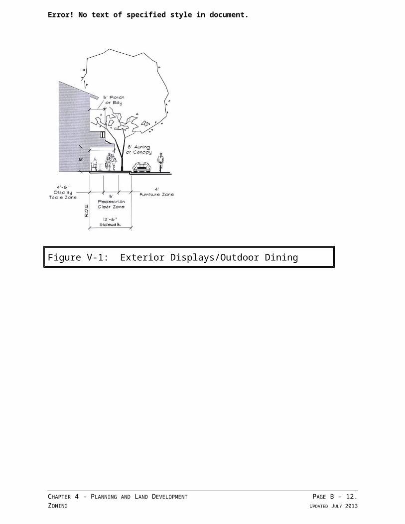
completely enclosed building; except for off-street parking and off-street loading. Except, however, that exterior displays, outdoor dining areas, or exterior sales may be specifically authorized through temporary use permit or development permit approval, subject to conditions of approval. Exterior sales that may be permitted are those that are limited in time duration, such as sidewalk sales, grand openings, or farmers’ markets. Said areas must maintain the minimum required clear space accessible to pedestrian movement on pathways and/or sidewalks. See the following figure:
CHAPTER 4 - PLANNING AND LAND DEVELOPMENT PAGE B – 8.ZONING UPDATED JULY 2013
Error! No text of specified style in document.
Figure V-1: Exterior Displays/Outdoor Dining
CHAPTER 4 - PLANNING AND LAND DEVELOPMENT PAGE B – 9.ZONING UPDATED JULY 2013
Error! No text of specified style in document.
6. Except as may be approved through the processes noted in Section (.07)(A)(5), above, all commercial uses shall meet the performance standards specified in Section 4.135(.05).
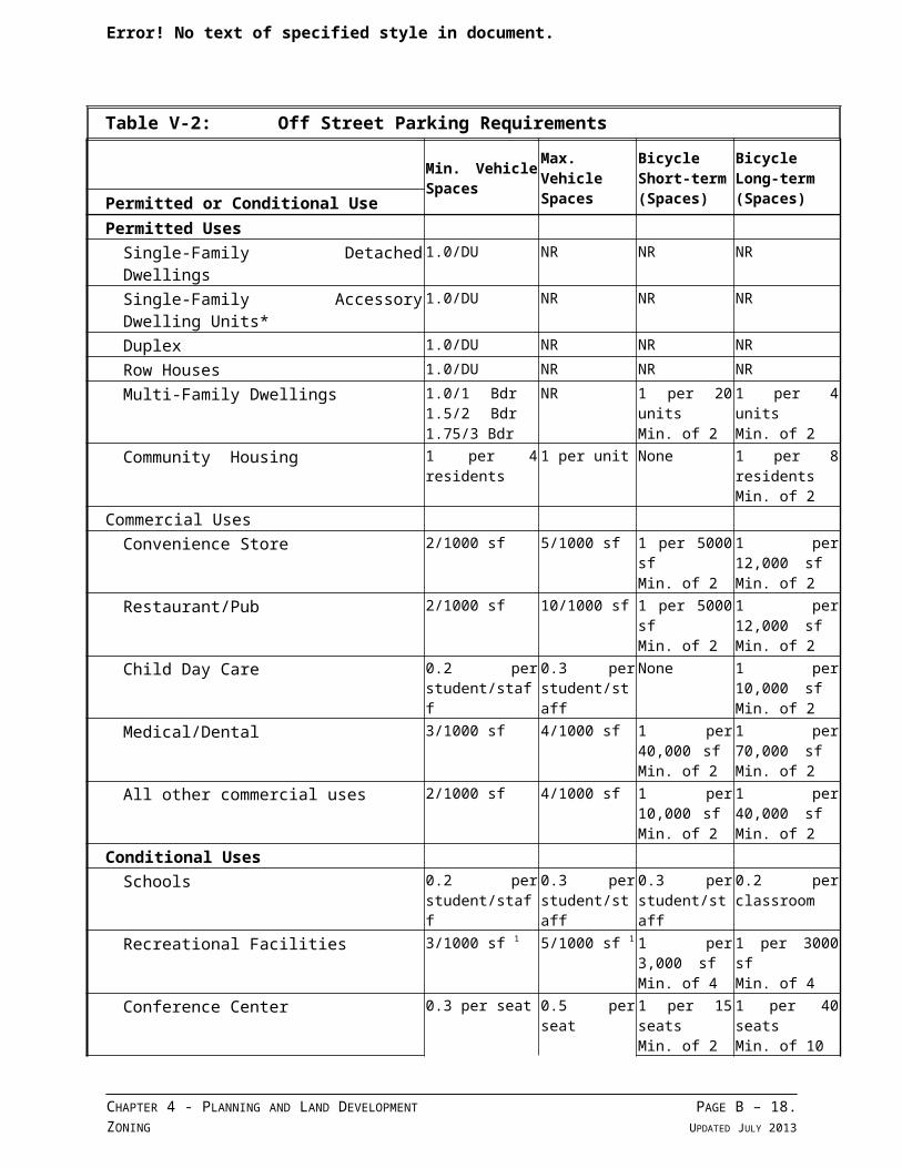
(.07) General Regulations - Off-Street Parking, Loading and Bicycle Parking Except as required by Subsections (A) through (D), below, the requirements of Section 4.155 shall apply within the Village zone.
A. General Provisions:1. The provision and maintenance of off-street parking spaces is a continuing
obligation of the property owner. The standards set forth herein shall be considered by the Development Review Board as minimum criteria.
2. The Board shall have the authority to grant variances or refinements to these standards in keeping with the purposes and objectives set forth in this zone.
B. Minimum and Maximum Off-Street Parking Requirements:1. Table V-2, Off-Street Parking Requirements, below, shall be used to
determine the minimum and maximum parking standards for noted land uses. The minimum number of required parking spaces shown in Table V-2 shall be determined by rounding to the nearest whole parking space. For example, a use containing 500 square feet, in an area where the standard is one space for each 400 square feet of floor area, is required to provide one off-street parking space. If the same use contained more than 600 square feet, a second parking space would be required.
2. Minimum parking requirements may be met by dedicated off-site parking, including surfaced parking areas and parking structures.
3. Except for detached single-family dwellings and duplexes, on-street parking spaces, directly adjoining and on the same side of the street as the subject property, may be counted towards meeting the minimum off-street parking requirements.
4. Minimum parking requirements may be reduced under the following conditions:a. When complimentary, shared parking availability can be demonstrated,
or;b. Bicycle parking may substitute for up to 25% of required Mixed-Use or
Multi-Family Residential parking. For every five non-required bicycle parking spaces that meet the short or long-term bicycle parking standards, the motor vehicle parking requirement for compact spaces may be reduced by one space.
C. Minimum Off-Street Loading Requirements:1. Loading facilities shall be sited at the rear or side whenever practicable, and
if adjacent to a residential use, shall be screened. Screening shall match the adjacent residential development in terms of quality of materials and design.
CHAPTER 4 - PLANNING AND LAND DEVELOPMENT PAGE B – 10.ZONING UPDATED JULY 2013
Error! No text of specified style in document.
Such screening shall minimize light glare and noise levels affecting adjacent residential uses. See also Section 4.155(.03)(B).
D. Bicycle Parking Requirements:1 Purpose: Bicycle parking is required for most use categories to encourage the
use of bicycles by providing safe and convenient places to park bicycles for short and long stays. a. Short-term bicycle parking is intended to encourage shoppers,
customers, messengers, and other visitors to use bicycles by providing a convenient and readily accessible place to park bicycles.
b. Long-term bicycle parking is intended to provide employees, students, residents, commuters and others who generally stay at a site for several hours, a secure and weather-protected place to park bicycles. The intent of the long-term standards is to provide bicycle parking within a reasonable distance in order to encourage bicycle use.
2. General Provisionsa. Required Bicycle Parking:
i. The required minimum number of bicycle parking spaces for each use category is shown in Table V-2, Parking Requirements, below. Bicycle parking is not required for uses not listed.
ii. Bicycle parking spaces are not required for accessory uses. If a primary use is listed in Table V-2, bicycle parking is not required for the accessory use.
iii. When there are two or more primary uses on a site, the required bicycle parking for the site is the sum of the required bicycle parking for the individual primary uses.
3. Bicycle Parking Standards:a. Short-term bicycle parking. Required short-term bicycle parking shall
meet the following standards: i. Short-term bicycle parking shall be provided in lockers or racks that
meet the standards of this section.ii. Short-term bicycle parking shall be located either within 30 feet of
the main entrance to the building; or inside a building, in a location that is easily accessible for bicycles.
iii. If 10 or more short-term bicycle spaces are required, then at least 50 percent of the required short-term bicycle spaces shall be covered and meet the standards of this section.
b. Long-term bicycle parking. Required long-term bicycle parking shall meet the following standards: i. Long-term bicycle parking shall be provided in racks or lockers that
meet the standards of this section.
CHAPTER 4 - PLANNING AND LAND DEVELOPMENT PAGE B – 11.ZONING UPDATED JULY 2013
Error! No text of specified style in document.
ii. Long-term bicycle parking shall be located on the site or in an area where the closest point is within 300 feet of the site
iii. At least 50 percent of required long-term bicycle parking shall be covered in compliance with the standards of this section
iv. To provide security, long-term bicycle parking shall be in at least one of the following locations: In a locked room or locker In an area that is enclosed by a fence with a locked gate. The
fence shall be either eight (8) feet high, or be floor-to-ceiling, subject to review and approval of a building permit;
In an area that is visible from employee work areas or within view of an attendant or security guard;
In a dwelling unit or dormitory unit. If long-term bicycle parking is provided in a dwelling unit or dormitory unit, neither racks nor lockers shall be required.
c. Bicycle Lockers, Racks and Cover (Weather Protection):i. Where required bicycle parking is provided in lockers, the lockers
shall be securely anchored. ii. Covered bicycle parking, as required by this section, shall be provided
inside buildings, under roof overhangs or awnings, in bicycle lockers, or within or under other structures. Where required covered bicycle parking is not within a building or locker, the cover must be permanent, designed to protect the bicycle from rainfall and provide seven (7) foot minimum overhead clearance.
CHAPTER 4 - PLANNING AND LAND DEVELOPMENT PAGE B – 12.ZONING UPDATED JULY 2013
Error! No text of specified style in document.
Table V-2: Off Street Parking Requirements
Min. Vehicle Spaces
Max. Vehicle Spaces
BicycleShort-term(Spaces)
BicycleLong-term(Spaces)Permitted or Conditional Use
Permitted UsesSingle-Family Detached Dwellings 1.0/DU NR NR NR
Single-Family Accessory Dwelling Units* 1.0/DU NR NR NR
Duplex 1.0/DU NR NR NR
Row Houses 1.0/DU NR NR NR
Multi-Family Dwellings 1.0/1 Bdr 1.5/2 Bdr 1.75/3 Bdr
NR 1 per 20 units Min. of 2
1 per 4 unitsMin. of 2
Community Housing 1 per 4 residents 1 per unit None 1 per 8 residentsMin. of 2
Commercial UsesConvenience Store 2/1000 sf 5/1000 sf 1 per 5000 sf
Min. of 21 per 12,000 sf Min. of 2
Restaurant/Pub 2/1000 sf 10/1000 sf 1 per 5000 sf Min. of 2
1 per 12,000 sf Min. of 2
Child Day Care 0.2 per student/staff
0.3 per student/staff
None 1 per 10,000 sf Min. of 2
Medical/Dental 3/1000 sf 4/1000 sf 1 per 40,000 sf Min. of 2
1 per 70,000 sf Min. of 2
All other commercial uses 2/1000 sf 4/1000 sf 1 per 10,000 sf Min. of 2
1 per 40,000 sf Min. of 2
Conditional UsesSchools 0.2 per
student/staff0.3 per student/staff
0.3 per student/staff
0.2 per classroom
Recreational Facilities 3/1000 sf 1 5/1000 sf 1 1 per 3,000 sf Min. of 4
1 per 3000 sf Min. of 4
Conference Center 0.3 per seat 0.5 per seat 1 per 15 seats Min. of 2
1 per 40 seats Min. of 10
Library/Museum 2/1000 sf 4/1000 sf 1 per 1000 sf Min. of 6
1 per 1000 sf Min. of 6
Religious Institution .25 per seat .5 per seat 1 per 2,000 sf Min. of 2
1 per 4,000 sf Min. of 2
Theater .25 per seat .5 per seat 1 per 20 seats Min. of 2
1 per 50 seats Min. of 4
Overnight Lodging Facility 1 per room 1.5 per room 1 per 20 rooms Min. of 2
1 per 20 rooms Min. of 2
Light Manufacturing/Research and Development
2/1000 sf 4/1000 sf 1 per 10,000 sf Min. of 2
1 per 40,000 sf Min. of 2
All other Conditional Uses 2/1000 sf 4/1000 sf 1 per 10,000 sf Min. of 2
1 per 40,000 sf Min. of 2
Notes: 1 1/1000 sf min. for court facilitiesNR No requirement* See WC Section 4.113(.11) Assessory Dwelling Units
CHAPTER 4 - PLANNING AND LAND DEVELOPMENT PAGE B – 13.ZONING UPDATED JULY 2013
Error! No text of specified style in document.
[Table 4-2 amended by Ord. 677, 3/1/10]
CHAPTER 4 - PLANNING AND LAND DEVELOPMENT PAGE B – 14.ZONING UPDATED JULY 2013
Error! No text of specified style in document.
(.08) Open Space. Open space shall be provided as follows:
A. In all residential developments and in mixed-use developments where the majority of the developed square footage is to be in residential use, at least twenty-five percent (25%) of the area shall be open space, excluding street pavement and surface parking. In multi-phased developments, individual phases are not required to meet the 25% standard as long as an approved Specific Area Plan demonstrates that the overall development shall provide a minimum of 25% open space. Required yard areas shall not be counted towards the required open space area.
B. Open space area required by this Section may, at the discretion of the Development Review Board, be protected by a conservation easement or dedicated to the City, either rights in fee or easement, without altering the density or other development standards of the proposed development. Provided that, if the dedication is for public park purposes, the size and amount of the proposed dedication shall meet the criteria of the City of Wilsonville standards. The square footage of any land, whether dedicated or not, which is used for open space shall be deemed a part of the development site for the purpose of computing density or allowable lot coverage. See SROZ provisions, Section 4.139.10.
C. The Development Review Board may specify the method of assuring the long-term protection and maintenance of open space and/or recreational areas. Where such protection or maintenance are the responsibility of a private party or homeowners’ association, the City Attorney shall review and approve any pertinent bylaws, covenants, or agreements prior to recordation.
(.09) Street and Access Improvement Standards
A. Except as noted below, the provisions of Section 4.177 shall apply within the Village zone:1. General Provisions:
a. All street alignment and access improvements shall conform to Figures 7, 8, 9A, and 9B of the Villebois Village Master Plan, or as refined in an approved Specific Area Plan, Preliminary Development Plan, or Final Development Plan, and the following standards:i. All street improvements shall conform to the Public Works Standards
and the Transportation Systems Plan, and shall provide for the continuation of streets through proposed developments to adjoining properties or subdivisions, according to the Master Plan.
ii. All streets shall be developed according to the Master Plan.2. Intersections of streets:
a. Angles: Streets shall intersect one another at angles not less than 90 degrees, unless existing development or topography makes it impractical.
CHAPTER 4 - PLANNING AND LAND DEVELOPMENT PAGE B – 15.ZONING UPDATED JULY 2013
Error! No text of specified style in document.
b. Intersections: If the intersection cannot be designed to form a right angle, then the right-of-way and paving within the acute angle shall have a minimum of a thirty (30) foot centerline radius and said angle shall not be less than sixty (60) degrees. Any angle less than ninety 90 degrees shall require approval by the City Engineer after consultation with the Fire District.
c. Offsets: Opposing intersections shall be designed so that no offset dangerous to the traveling public is created. Intersections shall be separated by at least:i. 1000 ft. for major arterialsii. 600 ft. for minor arterialsiii. 100 ft. for collectorsiv. 50 ft. for local streets[Amended by Ord. #719, 6/17/13.]
d. Curb Extensions:i. Curb extensions at intersections shall be shown on the Specific Area
Plans required in Subsection 4.125(.18)(C) through (F), below, and shall: Not obstruct bicycle lanes on collector streets. Provide a minimum 20 foot wide clear distance between curb
extensions at all local residential street intersections, meet minimum turning radius requirements of the Public Works Standards, and shall facilitate fire truck turning movements as required by the Fire District.
3. Street Grades: Street grades shall be a maximum of 6% on arterials and 8% for collector and local streets. Where topographic conditions dictate, grades in excess of 8%, but not more than 12%, may be permitted for short distances, as approved by the City Engineer, where topographic conditions or existing improvements warrant modification of these standards.
4. Centerline Radius Street Curves: The minimum centerline radius street curves shall be as follows:a. Arterial streets: 600 feet, but may be reduced to 400 feet in commercial
areas, as approved by the City Engineer.b. Collector streets: 600 feet, but may be reduced to conform with the
Public Works Standards, as approved by the City Engineer. c. Local streets: 75 feet
5. Rights-of-way:a. See Section 4.125(.09)(A), above.
6. Access drives:a. See Section 4.125(.09)(A), above.b. 16 feet for two-way traffic
CHAPTER 4 - PLANNING AND LAND DEVELOPMENT PAGE B – 16.ZONING UPDATED JULY 2013

Error! No text of specified style in document.
7. Clear Vision Areasa. See Section 4.125(.09)(A), above.
8. Vertical Clearance:a. See Section 4.125(.09)(A), above.
9. Interim Improvement Standard:a. See Section 4.125(.09)(A), above.
(.10) Sidewalk and Pathway Improvement Standards
A. The provisions of Section 4.154 and 4.177(.03) shall apply within the Village zone. [Amended by Ord. #719, 6/17/13.]
(.11) Landscaping, Screening and Buffering
A. Except as noted below, the provisions of Section 4.176 shall apply in the Village zone:1. Streets in the Village zone shall be developed with street trees as described
in the Community Elements Book.
(.12) Master Signage and Wayfinding
A. All signage and wayfinding elements within the Village Zone shall be in compliance with the adopted Signage and wayfinding Master Plan for the appropriate SAP.
B. Provisions of Sections 4.156.01 through 4.156.11 shall apply in the Village Zone except Sections 4.156.07 and 4.156.08. Portions of Section 4.156.08 pertaining to Town Center may be used for comparison purposes to assess conceptually whether signage is allowed in an equitable manner throughout the City. Sections 4.156.01 through 4.156.11 are not to be used for direct comparison of sign standards. [Amended by Ord. No. 704, 6/18/12]
C. The Master Signage and Wayfinding Plan is the Master Sign Plan for the applicable SAP.
D. In the event of conflict between the applicable standards of Sections 4.156.01 through 4.156.11 and this subsection or the applicable Master Signage and Wayfinding Plan, this subsection and the Master Signage and Wayfinding Plan shall take precedence. [Amended by Ord. No. 704, 6/18/12]
E. The following signs may be permitted in the Village Zone, subject to the conditions in this Section.1. Site Signs
a. Signs that capture attention establishing a sense of arrival to Villebois and to areas within Villebois.
2. Site Directional
CHAPTER 4 - PLANNING AND LAND DEVELOPMENT PAGE B – 17.ZONING UPDATED JULY 2013
Error! No text of specified style in document.
a. Permanent mounted signs informing and directing the public to major destinations within Villebois.
3. Retail Signsa. Signs which identify the retail uses, including bulkhead signs, blade signs,
temporary window signs and permanent window signs designed to identify storefronts an provide information regarding the retail uses.
4. Informational Signsa. Permanent mounted signs located along and adjacent to travel ways
providing information to residents and visitors traveling within Villebois.
CHAPTER 4 - PLANNING AND LAND DEVELOPMENT PAGE B – 18.ZONING UPDATED JULY 2013
Error! No text of specified style in document.
5. Flags and Bannersa. Permanent and temporary pole mounted signage intended to identify the
graphic identity of Villebois and to identify seasonal events taking place within the Villebois Community.
F. Dimensions and square footage of signs are defined in the Master Signage and Wayfinding Plan for the appropriate SAP.
G. Signage locations are specified in the Master Signage and Wayfinding Plan for the appropriate SAP.
H. The number of signs permitted is specified in the Master Signage and wayfinding Plan for he appropriate SAP.
[Section 4.125(.12) amended by Ord. No. 596, 10/3/05.]
(.13) Design Principles Applying to the Village Zone
A. The following design principles reflect the fundamental concepts, and support the objectives of the Villebois Village Master Plan, and guide the fundamental qualities of the built environment within the Village zone.1. The design of landscape, streets, public places and buildings shall create a
place of distinct character.2. The landscape, streets, public places and buildings within individual
development projects shall be considered related and connected components of the Villebois Village Master Plan.
3. The design of buildings shall functionally relate to adjacent open space, gateways, street orientation, and other features as shown in the Villebois Village Master Plan.
4. The design of buildings and landscape shall functionally relate to sunlight, climate, and topography in a way that acknowledges these conditions as particular to the Willamette Valley.
5. The design of buildings shall incorporate regional architectural character and regional building practices.
6. The design of buildings shall include architectural diversity and variety in its built form.
7. The design of buildings shall contribute to the vitality of the street environment through incorporation of storefronts, windows, and entrances facing the sidewalk.
8. The design of streets and public spaces shall provide for and promote pedestrian safety, connectivity and activity.
9. The design of buildings and landscape shall minimize the visual impact of, and screen views of off-street parking from streets.
CHAPTER 4 - PLANNING AND LAND DEVELOPMENT PAGE B – 19.ZONING UPDATED JULY 2013
Error! No text of specified style in document.
10. The design of exterior lighting shall minimize off-site impacts, yet enable functionality.
CHAPTER 4 - PLANNING AND LAND DEVELOPMENT PAGE B – 20.ZONING UPDATED JULY 2013
Error! No text of specified style in document.
(.14) Design Standards Applying to the Village Zone
A. The following Design Standards implement the Design Principles found in Section 4.125(.13), above, and enumerate the architectural details and design requirements applicable to buildings and other features within the Village (V) zone. The Design Standards are based primarily on the features, types, and details of the residential traditions in the Northwest, but are not intended to mandate a particular style or fashion. All development within the Village zone shall incorporate the following:.1. General Provisions:
a. Flag lots are not permitted.b. The minimum lot depth for a single-family dwelling with an accessory
dwelling unit shall be 70 feet.c. Village Center lots may have multiple front lot lines.d. For Village Center lots facing two or more streets, two of the facades
shall be subject to the minimum frontage width requirement. Where multiple buildings are located on one lot, the facades of all buildings shall be used to calculate the Minimum Building Frontage Width.
e. Neighborhood Centers shall only be located within a Neighborhood Commons.
f. Commercial Recreation facilities shall be compatible with surrounding residential uses.
g. Convenience Stores within the Village zone shall not exceed 4,999 sq. ft., and shall provide pedestrian access.
h. Specialty Grocery Stores within the Village zone shall not be more 19,999 square feet in size.
i. A Grocery Store shall not be more than 40,000 square feet in size.2. Building and site design shall include:
a. Proportions and massing of architectural elements consistent with those established in an approved Architectural Pattern Book or Village Center Architectural Standards.
b. Materials, colors and architectural details executed in a manner consistent with the methods included in an approved Architectural Pattern Book, Community Elements Book or approved Village Center Architectural Standards.
c. Protective overhangs or recesses at windows and doors.d. Raised stoops, terraces or porches at single-family dwellings.e. Exposed gutters, scuppers, and downspouts, or approved equivalent.f. The protection of existing significant trees as identified in an approved
Community Elements Book.g. A landscape plan in compliance with Sections 4.125(.07) and (.11), above.
CHAPTER 4 - PLANNING AND LAND DEVELOPMENT PAGE B – 21.ZONING UPDATED JULY 2013
Error! No text of specified style in document.
h. Building elevations of block complexes shall not repeat an elevation found on an adjacent block.
i. Building elevations of detached buildings shall not repeat an elevation found on buildings on adjacent lots.
j. A porch shall have no more than three walls.k. A garage shall provide enclosure for the storage of no more than three
motor vehicles, as described in the definition of Parking Space.3. Lighting and site furnishings shall be in compliance with the approved
Architectural Pattern Book, Community Elements Book, or approved Village Center Architectural Standards.
4. Building systems, as noted in Tables V-3 and V-4 (Permitted Materials and Configurations), below, shall comply with the materials, applications and configurations required therein. Design creativity is encouraged. The LEED Building Certification Program of the U.S. Green Building Council may be used as a guide in this regard.
[Section 4.125(.14) amended by Ord. No. 595, 12/5/05.]
CHAPTER 4 - PLANNING AND LAND DEVELOPMENT PAGE B – 22.ZONING UPDATED JULY 2013
Error! No text of specified style in document.
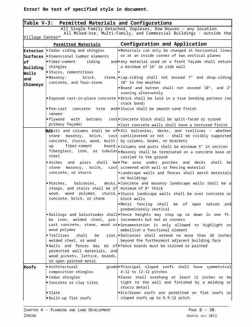
Table V-3: Permitted Materials and Configurations All Single Family Detached, Duplexes, Row Houses - any location All Mixed-Use, Multi-Family, and Commercial Buildings - outside the Village Center*
Permitted Materials Configuration and ApplicationExterior Surfaces of Building Walls and Chimneys
Cedar siding and shingles Materials can only be changed at horizontal lines or at an inside corner of two vertical planes Dimensional lumber elements
Fiber-cement siding and shingles Any material used on a front façade shall return a minimum of 16" on side wall Stucco, cementitious
Masonry: brick, stone, concrete, and faux-stone
Lap-siding shall not exceed 7" and drop-siding 10" to the weather Board and batten shall not exceed 10", and 2" running alternately
Exposed cast-in-place concrete Brick shall be laid in a true bonding pattern (no stack bond) Pre-cast concrete trim and veneer Stucco shall be smooth sand finish Plywood with battens (not primary façade) Concrete block shall be split-faced or scored
Cast concrete walls shall have a textured finishBuil Posts and columns shall be of stone masonry,
brick, cast concrete, stucco, wood, built-up fiber-cement board, fiberglass, iron, or tubular steel
All balconies, decks, and trellises - whether cantilevered or not - shall be visibly supported by columns, beams, or brackets
Columns and posts shall be minimum 5" in section Masonry shall be terminated on a concrete base or carried to the ground
Arches and piers shall be stone masonry, brick, cast concrete, or stucco
The area under porches and decks shall be screened with wall or fencing material
Landscape walls and fences shall match materials on buildings Porches, balconies, decks, stoops, and stairs
shall be of wood, wood polymer, stucco, concrete, brick, or stone
Concrete and masonry landscape walls shall be a minimum of 8" thick Stucco landscape walls shall be over concrete or block walls Metal fencing shall be of open nature and predominately vertical
Railings and balustrades shall be iron, welded steel, pre-cast concrete, stone, wood or wood polymer
Fence heights may step up or down in one ft. increments but not at corners
Ornamentation is only allowed to highlight or embellish a functional element
Trellises shall be iron, welded steel, or wood Balconies shall extend no more than 36 inches beyond the furthermost adjacent building face
Walls and fences may be of permitted wall materials, and wood pickets, lattice, boards, or open painted metal
Fence boards must be stained or painted
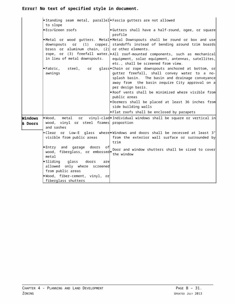
Roofs Architectural grade composition shingles Principal sloped roofs shall have symmetrical 4:12 to 12:12 pitches Cedar shingles Eaves shall overhang at least 12 inches or be tight to the wall and
finished by a molding or stucco detail Concrete or clay tiles Slate Eco/Green roofs are permitted on flat roofs or sloped roofs up to 6.9:12
pitch. Built-up flat roofs Standing seam metal, parallel to slope Fascia gutters are not allowed Eco/Green roofs Gutters shall have a half-round, ogee, or square profile Metal or wood gutters. Metal downspouts or
(1) copper, brass or aluminum chain, (2) rope, or (3) freefall water, in lieu of metal downspouts.
Metal Downspouts shall be round or box and use standoffs instead of bending around trim boards or other elements.
All roof-mounted components, such as mechanical equipment, solar equipment, antennas, satellites, etc., shall be screened from view.
Fabric, steel, or glass awnings Chain or rope downspouts anchored at bottom, or gutter freefall, shall convey water to a no-splash basin. The basin and drainage conveyance away from the basin require City approval on a per design basis.
Roof vents shall be minimized where visible from public areas
Dormers shall be placed at least 36 inches from side building walls
Flat roofs shall be enclosed by parapets
Windows & Doors
Wood, metal or vinyl-clad wood, vinyl or steel frames and sashes
Individual windows shall be square or vertical in proportion
Clear or Low-E glass where visible from public areas
Windows and doors shall be recessed at least 3" from the exterior wall surface or surrounded by trim
Entry and garage doors of wood, fiberglass, or embossed metal Door and window shutters shall be sized to cover the window
Sliding glass doors are allowed only where screened from public areas
CHAPTER 4 - PLANNING AND LAND DEVELOPMENT PAGE B – 23.ZONING UPDATED JULY 2013
Error! No text of specified style in document. Wood, fiber-cement, vinyl, or fiberglass
shutters
CHAPTER 4 - PLANNING AND LAND DEVELOPMENT PAGE B – 24.ZONING UPDATED JULY 2013
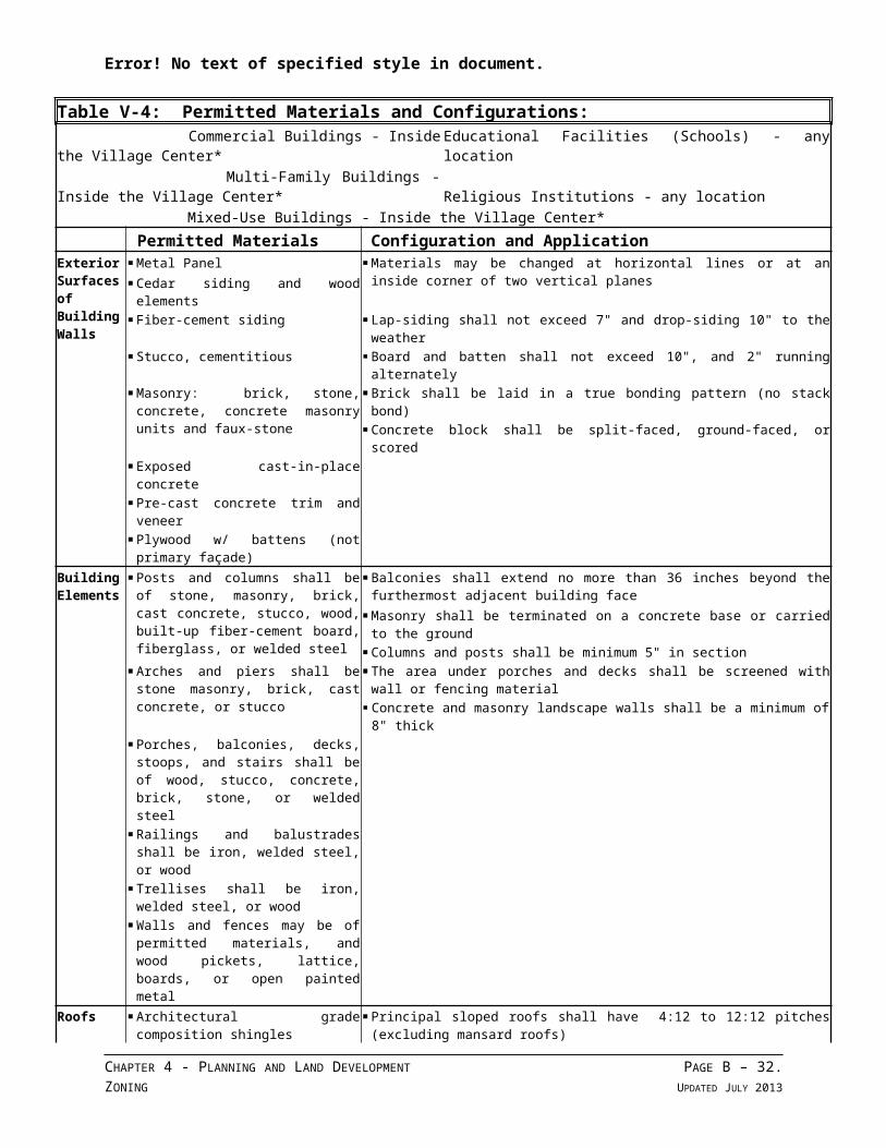
Error! No text of specified style in document.
Table V-4: Permitted Materials and Configurations: Commercial Buildings - Inside the Village Center* Educational Facilities (Schools) - any location Multi-Family Buildings - Inside the Village Center* Religious Institutions - any location Mixed-Use Buildings - Inside the Village Center*
Permitted Materials Configuration and ApplicationExterior Surfaces of Building Walls
Metal Panel Materials may be changed at horizontal lines or at an inside corner of two vertical planes Cedar siding and wood elements
Fiber-cement siding Lap-siding shall not exceed 7" and drop-siding 10" to the weather Stucco, cementitious Board and batten shall not exceed 10", and 2" running alternately Masonry: brick, stone, concrete, concrete
masonry units and faux-stone Brick shall be laid in a true bonding pattern (no stack bond) Concrete block shall be split-faced, ground-faced, or scored
Exposed cast-in-place concrete
Pre-cast concrete trim and veneer
Plywood w/ battens (not primary façade)
Building Elements
Posts and columns shall be of stone, masonry, brick, cast concrete, stucco, wood, built-up fiber-cement board, fiberglass, or welded steel
Balconies shall extend no more than 36 inches beyond the furthermost adjacent building face
Masonry shall be terminated on a concrete base or carried to the ground Columns and posts shall be minimum 5" in section
Arches and piers shall be stone masonry, brick, cast concrete, or stucco
The area under porches and decks shall be screened with wall or fencing material Concrete and masonry landscape walls shall be a minimum of 8" thick
Porches, balconies, decks, stoops, and stairs shall be of wood, stucco, concrete, brick, stone, or welded steel
Railings and balustrades shall be iron, welded steel, or wood
Trellises shall be iron, welded steel, or wood
Walls and fences may be of permitted materials, and wood pickets, lattice, boards, or open painted metal
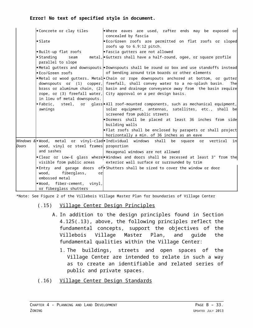
Roofs Architectural grade composition shingles Principal sloped roofs shall have 4:12 to 12:12 pitches (excluding mansard roofs) Concrete or clay tiles Where eaves are used, rafter ends may be exposed or concealed by fascia Slate Eco/Green roofs are permitted on flat roofs or sloped roofs up to 6.9:12 pitch. Built-up flat roofs Fascia gutters are not allowed Standing seam metal, parallel to slope Gutters shall have a half-round, ogee, or square profile Metal gutters and downspouts Downspouts shall be round or box and use standoffs instead of bending around trim
boards or other elements Eco/Green roofs Metal or wood gutters. Metal
downspouts or (1) copper, brass or aluminum chain, (2) rope, or (3) freefall water, in lieu of metal downspouts.
Chain or rope downspouts anchored at bottom, or gutter freefall, shall convey water to a no-splash basin. The basin and drainage conveyance away from the basin require City approval on a per design basis.
Fabric, steel, or glass awnings All roof-mounted components, such as mechanical equipment, solar equipment, antennas, satellites, etc., shall be screened from public streets
Dormers shall be placed at least 36 inches from side building walls
Flat roofs shall be enclosed by parapets or shall project horizontally a min. of 36 inches as an eave
Windows & Doors
Wood, metal or vinyl-clad wood, vinyl or steel frames and sashes
Individual windows shall be square or vertical in proportionHexagonal windows are not allowed
Clear or Low-E glass where visible from public areas
Windows and doors shall be recessed at least 3" from the exterior wall surface or surrounded by trim
Entry and garage doors of wood, fiberglass, or embossed metal
Shutters shall be sized to cover the window or door
Wood, fiber-cement, vinyl, or fiberglass shutters
CHAPTER 4 - PLANNING AND LAND DEVELOPMENT PAGE B – 25.ZONING UPDATED JULY 2013
Error! No text of specified style in document.
*Note: See Figure 2 of the Villebois Village Master Plan for boundaries of Village Center
(.15) Village Center Design Principles
A. In addition to the design principles found in Section 4.125(.13), above, the following principles reflect the fundamental concepts, support the objectives of the Villebois Village Master Plan, and guide the fundamental qualities within the Village Center:1. The buildings, streets and open spaces of the Village Center are intended to
relate in such a way as to create an identifiable and related series of public and private spaces.
(.16) Village Center Design Standards
A. In addition to the design standards found in Section 4.125(.14), above, the following Design Standards are applicable to the Village Center, exclusive of single-family detached dwellings and row houses:1. Off-street parking areas shall not be located between buildings and the
street.2. The design of off-street parking areas shall include pedestrian connections to
the buildings they serve, sidewalks, and adjacent parking areas.3. The design of buildings and public spaces shall include interior (through-
buildings) and exterior public pedestrian accessways, as required, to facilitate pedestrian connections.
4. The design of buildings shall include rear and side entrances in addition to primary street front entrances when necessary to facilitate pedestrian connections.
5. Building facades shall be broken into multiple vertical elements.6. Canopies and awnings should be provided as specified in the Village Center
Architectural Standards. [Section 4.125(.16)(A)(6) amended by Ord. No. 595, 12/5/05.]
7. The design of buildings and landscapes shall provide opportunities for public art at a minimum of one location per block.
(.17) Village Center Plaza Design Standards
A. In addition to the design standards found in Section 4.125(.16), above, the following Design Standards are specific to the design of the Village Center Plaza:1. The Village Center Plaza shall be measured as all space enclosed by the
surrounding buildings.2. The Village Center Plaza landscape shall consist of textured paving
differentiated from typical street pavement. Vehicular movement and on-street parking within the Village Center Plaza is encouraged to have similar paving treatments and occur at the same elevation as the sidewalk and the Village Center Plaza.
CHAPTER 4 - PLANNING AND LAND DEVELOPMENT PAGE B – 26.ZONING UPDATED JULY 2013
Error! No text of specified style in document.
3. The Village Center Plaza shall include the following:a. Incorporation of existing significant trees, street furniture, bollards or
similar elements, and exterior lighting.b. One vertical tower element facing the Village Center Plaza with
proportions, massing, and architectural elements consistent with the Village Center Architectural Standards.
[Section 4.125(.17) amended by Ord. No. 595, 12/5/05.]
(.18) Village Zone Development Permit Process. Except as noted below, the provision of Sections 4.140(.02) through (.06) shall apply to development in the Village zone.
A. Purpose and Intent. It is the purpose of this subsection to describe the process by which development plans are proposed, reviewed and adopted and to provide the procedures and criteria for development permit application, review and approval.
B. Unique Features and Processes of the Village (V) Zone : To be developed, there are three (3) phases of project approval. Some of these phases may be combined, but generally the approvals move from the conceptual stage through to detailed architectural, landscape and site plan review in stages. All development within the Village zone shall be subject to the following processes:1. Specific Area Plan (SAP) approval by the Development Review Board, as set
forth in Sections 4.125(.18)(C) through (F), below (Stage I equivalent). To be developed, a site must be included in an approved SAP.
2. Preliminary Development Plan (PDP) approval by the Development Review Board, as set forth in Sections 4.125(.18)(G) through (K) (Stage II equivalent), below. Following SAP approval, an applicant may file applications for Preliminary Development Plan approval (Stage II equivalent) for an approved phase in accordance with the approved SAP, and any conditions attached thereto. Land divisions may also be preliminarily approved at this stage. Except for land within the Central SAP or multi-family dwellings outside the Central SAP, application for a Zone Change and Final Development Plan (FDP) shall be made concurrently with an application for PDP approval. The SAP and PDP/FDP may be reviewed simultaneously when a common ownership exists.Final Development Plan (FDP) approval by the Development Review Board or the Planning Director, as set forth in Sections 4.125(.18)(L) through (P) (Site Design Review equivalent), below, may occur as a separate phase for lands in the Central SAP or multi-family dwellings outside the Central SAP.
3. Administrative Review approvals, by the Planning Director, as set forth in Section 4.030. Prior to commencement of development, final approval for land divisions, tree removal permits, grading permits, and compliance with prior approvals must be received. Development permit issuance follows completion of the foregoing stages.
[Section 4.125(.18)(B) amended by Ord. No. 587, 5/16/05.]
CHAPTER 4 - PLANNING AND LAND DEVELOPMENT PAGE B – 27.ZONING UPDATED JULY 2013
Error! No text of specified style in document.
C. Specific Area Plan (SAP) Application Procedures.1. Purpose – A SAP is intended to advance the design of the Villebois Village
Master Plan.2. If not initiated by the City Council, Planning Commission or Development
Review Board, an application for SAP approval shall be submitted by the Master Planner, or by landowners pursuant to subsection C.3 below. The application shall be accompanied by payment of a fee established in accordance with the City’s fee schedule.
3. The owners of property representing at least 80 percent of a SAP area may request in writing that the Master Planner submit a SAP application. The Master Planner must provide a written response within thirty days. If the Master Planner agrees to submit a request, the Master Planner shall have 180 days to submit the SAP application. If the Master Planner denies the request, fails to respond within 30 days, or fails as determined by the Planning Director to diligently pursue the application after agreeing to submit it, by providing drafts of a pattern book and all other SAP elements within 60 days and thereafter pursuing approval in good faith, the property owners may submit a SAP application for review and approval. A copy of a SAP application submitted by property owners must be provided to the Master Planner. Once the application has been deemed complete by the City, the Master Planner shall have 30 days to review and comment in writing before the proposed SAP is scheduled for public hearing by the DRB.
D. SAP Application Submittal Requirements:1. Existing Conditions – An application for SAP approval shall specifically and
clearly show the following features and information on maps, drawings, application form or attachments. The SAP shall be drawn at a scale of 1" = 100' (unless otherwise indicated) and may include multiple sheets depicting the entire SAP area, as follows:a. Date, north arrow and scale of drawing.b. The boundaries of the Specific Area Plan as may be refined and in keeping
with the intent of the Villebois Village Master Plan's conceptual location of SAPs. (See Figure 3 "Conceptual Specific Area Plan Boundaries" of the Villebois Village Master Plan.) [Amended by Ord. 565, adopted 6/21/04.]
c. A vicinity map showing the location of the SAP sufficient to define its location and boundaries and Clackamas County Tax Assessor's map numbers of the tract boundaries. The vicinity map shall clearly identify the nearest cross streets.
d. An aerial photograph (at 1" = 500') of the proposed site and properties within 50 feet of the SAP boundary.
e. The size, dimensions, and zoning of each lot or parcel tax lot and Tax Assessor's map designations for the SAP and properties within 50 feet of the SAP boundary.
CHAPTER 4 - PLANNING AND LAND DEVELOPMENT PAGE B – 28.ZONING UPDATED JULY 2013
Error! No text of specified style in document.
f. The location, dimensions and names, as appropriate, of existing and platted streets and alleys on and within 50 feet of the perimeter of the SAP, together with the location of existing and planned easements, sidewalks, bike routes and bikeways, trails and the location of other important features such as section lines, section corners, and City boundary lines. The plan shall also identify all trees 6 inches and greater d.b.h. on the project site only in that SAP .
g. Contour lines shall relate to North American Vertical Datum of 1988 and be at minimum intervals as follows:i. One (1) foot contours for slopes of up to five percent (5%);ii. Two (2) foot contours for slopes of from six percent (6%) to twelve
percent (12%);iii. Five (5) foot contours for slopes of from twelve percent (12%) to
twenty percent (20%). These slopes shall be clearly identified, andiv. Ten (10) foot contours for slopes exceeding twenty percent (20%).
h. The location of areas designated Significant Resource Overlay Zone (SROZ), and associated 25-foot Impact Areas, within the SAP and within 50 feet of the SAP boundary, as required by Section 4.139.
2. SAP Development Information – The following information shall also be shown at a scale of 1" = 100' and may include multiple sheets depicting the entire SAP area:a. A site circulation plan showing the approximate location of proposed
vehicular, bicycle and pedestrian access points and circulation patterns, and parking and loading areas.
b. The approximate location of all proposed streets, alleys, other public ways, curb extensions, sidewalks, bicycle and pedestrian accessways, neighborhood commons, and easements. The map shall identify existing subdivisions and development and un-subdivided land ownerships adjacent to the proposed SAP site.
c. The approximate project location, acreage, type, preliminary lot lines and density of the proposed development. For the residential portions of the SAP, the master planner shall identify: 1) the overall minimum and maximum number of housing units to be provided; and 2) the overall minimum and maximum number of housing units to be provided, by housing type.
d. The approximate locations of proposed parks, playgrounds or other outdoor play areas, outdoor common areas, usable open spaces, and natural resource areas or features proposed for preservation. This information shall include identification of areas proposed to be dedicated or otherwise preserved for public use and those open areas to be maintained and controlled by the owners of the property and their successors in interest for private use. This information shall be provided in tabular form, and shall reconcile all such areas as may have been adjusted through prior approvals.
CHAPTER 4 - PLANNING AND LAND DEVELOPMENT PAGE B – 29.ZONING UPDATED JULY 2013
Error! No text of specified style in document.
e. A composite utility plan illustrating existing and proposed water, sanitary sewer, and storm drainage facilities necessary to serve the SAP.
f. A grading plan illustrating existing and proposed contours as prescribed previously in this section.
g. A development sequencing planh. A utilities sequencing plani. A bicycle and pedestrian circulation planj. A tree removal, preservation and protection plank. A property ownership list, as required by Section 4.035(.04)(A)(6)(j).l. At the applicant’s expense, the City shall have a Traffic Impact Analysis
prepared, as required by Section 4.030(.02)(B), to review the anticipated traffic impacts of the proposed development. This traffic report shall include an analysis of the impact of the SAP on the local street and road network, and shall specify the maximum projected average daily trips and maximum parking demand associated with buildout of the entire SAP, and it shall meet Subsection 4.140(.09)(J)(2).
m. A master signage and wayfinding plann. A rainwater management program
3. Architectural Pattern Book – An Architectural Pattern Book shall be submitted with a SAP application. The Architectural Pattern Book shall apply to all development outside of the Village Center Boundary, as shown on Figure 1 of the currently adopted Villebois Village Master Plan. An Architectural Pattern Book shall address the following: [Section 4.125(.18)(D)(3) was amended by Ord. No. 595, 12/5/05.]a. Illustrate areas within the Specific Area Plan covered by the Architectural
Pattern Book.b. An explanation of how the Architectural Pattern Book is organized, and
how it is to be used.c. Define specific standards for architecture, color, texture, materials, and
other design elements.d. Include a measurement or checklist system to facilitate review of
development conformity with the Architectural Pattern Book.e. Include the following information for all row houses, duplexes, and
single-family detached housing inside and outside of the Village Center, and for all other buildings outside of the Village Center, including Neighborhood Center(s) within the SAP:i. Illustrate and describe the Regional and Climatic conditions affecting
the SAP, and the proposed building types including: Relationship of indoor and outdoor spaces. Design for rainwater paths including roof forms, gutters, scuppers
and downspouts. Design for natural day-lighting. Massing and materials.
CHAPTER 4 - PLANNING AND LAND DEVELOPMENT PAGE B – 30.ZONING UPDATED JULY 2013
Error! No text of specified style in document.
f. Illustrate and describe examples of appropriate architectural styles and how they would be applied to specific land use types, including the definitions (i.e., specifications) of the elements, massing, and facade composition for each style including:i. Architectural precedent and/or historic relevance of each style.ii. Massing, proportions, and roof forms, including details.iii. Doors, windows and entrances showing trim types and details.iv. Porches, chimneys and unique features and details.v. Materials, colors, light fixtures and accents.vi. Downspouts and gutters.
g. Illustrate and describe examples of appropriate exterior lighting types, and how their design:i. Minimizes glare.ii. Minimizes emission of light beyond the boundaries of a development
site.iii. Conserves energy.iv. Maintains nighttime safety, utility, security, and productivity.v. Minimizes the unnatural brightening of the night sky.
h. A Master Fencing Program illustrating and describing the specifications and materials for fencing within the SAP. [Section 4.125(.18)(D)(3.)(h) added by Ord. No. 596, 10/305.]
4. Community Elements Book – A Community Elements Book shall be submitted, including the following:a. Lighting Master Plan and Specifications, which address the requirements
of Section 4.125(.18)(D)(3)(g), above.b. Lighting Master Plan and Specificationsc. Site Furnishings Master Plan and Specificationsd. Curb Extensions Master Plan and Specificationse. Street Tree Master Plan and Specificationsf. Post Box Specificationsg. Bollard Specificationsh. Trash Receptacle Specificationsi. Recycling Receptacle Specificationsj. Bench Specificationsk. Bicycle Rack and Locker Specificationsl. Playground Equipment Specificationsm. Master Plant List and Specificationsn. For SAP Central, provide additional information regarding the elements
within the Address Overlay Areas.[Section 4.125(.18)(D)(4) amended by Ord. No. 595, 12/5/05.]
5. Rainwater Management Program – A Rainwater Management Program shall be submitted, addressing the following:
CHAPTER 4 - PLANNING AND LAND DEVELOPMENT PAGE B – 31.ZONING UPDATED JULY 2013
Error! No text of specified style in document.
a. Provision for opportunities to integrate water quality, detention, and infiltration into the SAP's natural features and proposed development areas;
b. Provision of methods reducing the increase in runoff from the 90 th
percentile of all rain events and meet pre-development hydrology to the greatest extent practicable;
c. Identification of guidelines and standards for the design of all Rainwater Management Systems within the SAP, that:i. Manage the ¼-inch, 24-hour rainfall event at pre-development levels.ii. Mitigate 100% of impervious area from private areas within public
areas and/or private areas (i.e., parks and open space areas, public street rights-of-way).
iii. Mitigate 100% of impervious area from all public areas within public areas (i.e., parks and open space areas, public street rights-of-way).
iv. Remove 70% of Total Suspended Solids (TSS) for ¼-inch, 24-hour storm event for all development areas.
v. Remove 65% of Phosphorous for ¼-inch, 24-hour storm event for all development areas.
vi. Integrate compost-amended topsoil in all areas to be landscaped to help detain runoff, reduce irrigation and fertilizer needs, and create a sustainable, low-maintenance landscape.
vii. Treatment associated with stormwater runoff will be considered in meeting Total Suspended Solids (TSS) and Phosphorus removal requirements.
[Section 4.125(.18)(D)(5)(c) amended by Ord. No. 579, 3/7/05]
6. Master Signage and Wayfinding – A Master Signage and Wayfinding Plan shall be submitted with an SAP application and shall address the following:a. Illustrate the boundaries of the SAP covered by the Master Signage and
Wayfinding Plan.b. An explanation of how the Master Signage and Wayfinding Plan is
organized and how it is to be used.c. Define specific standards for signage and wayfinding elements within the
subject SAP.d. Define specifications for logo, typography, symbols and color palette.e. Narrative shall be submitted as part of the application to adopt the
Master Signage and Wayfinding Plan showing how the proposed Master Signage and Wayfinding Plan meets the Purpose statement of W.C. Section 4.156.01 and how the proposed Plan is consistent with site signs, sited directional signs and information signs in other Villebois SAPs. Narrative shall also be provided describing how the proposed Master Signage and Wayfinding Plan compares conceptually with the signage allowed in the Wilsonville Town Center, as described in Section 4.156.08, to ensure that signage is allowed in a equitable manner throughout the
CHAPTER 4 - PLANNING AND LAND DEVELOPMENT PAGE B – 32.ZONING UPDATED JULY 2013
Error! No text of specified style in document.
City. Section 4.156.08 is not to be used for a direct comparison of sign standards. [Section 4.125(18)(D)(6) added by Ord. No. 596, 10/3/05. Subsequent subsection numbering adjusted.] [Amended by Ord. No. 704, 6/18/12]
7. Village Center Architectural Standards – Village Center Architectural Standards shall be submitted with an application for the Central SAP. The Village Center Architectural Standards shall apply to the portion of SAP Central within the Village Center boundary. This area is shown on Figure 1 of the currently adopted Master Plan. The Village Center Architectural Standards shall address the following:a. Provide an explanation of how the Village Center Architectural Standards
is organized, and how it is to be used.b. Include a measurement or checklist system to facilitate review of
development conformity with the Village Center Architectural Standards.c. The Village Center Architectural Standards shall address Village Center
Design Standards required by Sections 4.125(.16) and (.17), above.d. Illustrate the boundaries of all Address Overlay Areas.e. For each Address Overlay Area, the Village Center Architectural Standards
shall include a narrative describing the intended characteristics.f. The Village Center Architectural Standards shall include standards for all
buildings regarding the following elements:i. Building massing and proportionsii. Roof forms, including typical componentsiii. Building components, including but not limited to:
Doors and primary entrances Canopies and awnings Windows Porches, balconies, bay windows.
iv. Exterior materials and color paletteg. The Village Center Architectural Standards shall work in coordination with
the following SAP documents:i. The Parks and Open Space Planii. The Site Circulation Planiii. Composite Utility Planiv. The Master Signage and Wayfinding Planv. The Community Elements Bookvi. The Rainwater Management Program[Section 4.125(.18)(D)(6) amended by Ord. No 595, 12/5/05.]
8. SAP Narrative Statement – A narrative statement shall be submitted, addressing the following:a A description, approximate location and timing of each proposed phase
of development within the SAP.
CHAPTER 4 - PLANNING AND LAND DEVELOPMENT PAGE B – 33.ZONING UPDATED JULY 2013
Error! No text of specified style in document.
b. An explanation of how the proposed development complies with the applicable standards of this section.
c. A statement describing the impacts of the proposed development on natural resources within the SAP and how the proposed development complies with the applicable requirements of Chapter 4.
d. Includes a description of the goals and objectives of the Villebois Village Master Plan and the Design Principles of the V-Zone, and how they will be met for the specified land use area.
e. Includes information demonstrating how the Architectural Pattern Book satisfies the goals and concepts of the Villebois Village Master Plan, the Design Principles and Design Standards of the Village zone.
f. Where applicable, a written description of the proposal’s conformance with the Village Center Design Principles and Standards.
E. SAP Approval Process and Review Criteria1. An application for SAP approval shall be reviewed using the following
procedures:a. Notice of a public hearing before the Development Review Board
regarding a proposed SAP shall be made in accordance with the procedures contained in Section 4.012.
b. The Development Review Board may approve an application for SAP approval only upon finding the following approval criteria are met:i. That the proposed SAP:
Is consistent with the standards identified in this section. Complies with the applicable standards of the Planning and Land
Development Ordinance, and Is consistent with the Villebois Village Master Plan. Those
elements of the Village Master Plan with which the SAP must be consistent are the Plan’s Goals, Policies, and Implementation Measures, and, except as the text otherwise provides, Figures 1, 5, 6A, 7, 8, 9A, and 9B.
ii. If the SAP is to be phased, as enabled by Sections 4.125(.18)(D)(2)(g) and (h), that the phasing sequence is reasonable.
iii. The Development Review Board may require modifications to the SAP, or otherwise impose such conditions, as it may deem necessary to ensure conformance with the Villebois Village Master Plan, and compliance with applicable requirements and standards of the Planning and Land Development Ordinance, and the standards of this section.
F. Refinements to Approved Villebois Village Master Plan 1. In the process of reviewing a SAP for consistency with the Villebois Village
Master Plan, the Development Review Board may approve refinements, but not amendments, to the Master Plan. Refinements to the Villebois Village
CHAPTER 4 - PLANNING AND LAND DEVELOPMENT PAGE B – 34.ZONING UPDATED JULY 2013
Error! No text of specified style in document.
Master Plan may be approved by the Development Review Board, upon the applicant's detailed graphic demonstration of compliance with the criteria set forth in Section 4.125(.18)(F)(2), below. Amendments to the Villebois Village Master Plan may be approved by the Planning Commission as set forth in Section 4.032(.01)(B).a. Refinements to the Master Plan are defined as:
i. Changes to the street network or functional classification of streets that do not significantly reduce circulation system function or connectivity for vehicles, bicycles or pedestrians.
ii. Changes to the nature or location of park type, trails, or open space that do not significantly reduce function, usability, connectivity, or overall distribution or availability of these uses in the Specific Area Plan.
iii. Changes to the nature or location of utilities or storm water facilities that do not significantly reduce the service or function of the utility or facility.
iv. Changes to the location or mix of land uses that do not significantly alter the overall distribution or availability of uses in the affected SAP. For purposes of this subsection, “land uses” or “uses” are defined in the aggregate, with specialty condos, mixed use condos, urban apartments, condos, village apartments, neighborhood apartments, row houses and small detached uses comprising a land use group and medium detached, standard detached, large and estate uses comprising another.
v. A change in density that does not exceed ten percent, provided such density change does not result in fewer than 2,300 dwelling units in the Village.
vi. Changes that are significant under the above definitions, but necessary to protect an important community resource or substantially improve the function of collector or minor arterial streets. [Amended by Ord. 682, 9/9/10]
b. As used herein, “significant” means:i. More than ten percent of any quantifiable matter, requirement, or
performance measure, as specified in (.18)(F)(1)(a), above, or,ii. That which negatively affects an important, qualitative feature of the
subject, as specified in (.18)(F)(1)(a), above.2. Refinements meeting the above definition may be approved by the DRB
upon the demonstration and finding that:a. The refinements will equally or better meet the Goals, Policies and
Implementation Measures of the Villebois Village Master Planb. The refinement will not result in significant detrimental impacts to the
environment or natural or scenic resources of the SAP and Village area, and
CHAPTER 4 - PLANNING AND LAND DEVELOPMENT PAGE B – 35.ZONING UPDATED JULY 2013
Error! No text of specified style in document.
c. The refinement will not preclude an adjoining or subsequent SAP area from development consistent with the Master Plan.
3. Amendments are defined as changes to elements of the Master Plan not constituting a refinement. Amendments to the Master Plan must follow the same procedures applicable to adoption of the Master Plan itself.
G. Preliminary Development Plan Approval Process (Equivalent to Stage II): 1. An application for approval of a Preliminary Development Plan for a
development in an approved SAP shall:a. Be filed with the City Planning Division for the entire SAP, or when
submission of the SAP in phases has been authorized by the Development Review Board, for a phase in the approved sequence.
b. Be made by the owner of all affected property or the owner's authorized agent; and
c. Be filed on a form prescribed by the City Planning Division and filed with said division and accompanied by such fee as the City Council may prescribe by resolution; and
d. Set forth the professional coordinator and professional design team for the project; and
e. State whether the development will include mixed land uses, and if so, what uses and in what proportions and locations.
f. Include a preliminary land division (concurrently) per Section 4.200, as applicable.
g. Include a concurrent application for a Zone Map Amendment (i.e., Zone Change) for the subject phase.
2. The application for Preliminary Development Plan approval shall include conceptual and quantitatively accurate representations of the entire development sufficient to demonstrate conformance with the approved SAP and to judge the scope, size and impact of the development on the community and shall be accompanied by the following information:
a. A boundary survey or a certified boundary description by a surveyor licensed in the State of Oregon.
b. Topographic information sufficient to determine direction and percentage of slopes, drainage patterns, and in environmentally sensitive areas, (e.g., flood plain, wetlands, forested areas, steep slopes or adjacent to stream banks). Contour lines shall relate to North American Vertical Datum of 1988and be at minimum intervals as follows:i. One (1) foot contours for slopes of up to five percent (5%);ii. Two (2) foot contours for slopes of from six percent (6%) to twelve
percent (12%);iii. Five (5) foot contours for slopes of from twelve percent (12%) to
twenty percent (20%). These slopes shall be clearly identified, andiv. Ten (10) foot contours for slopes exceeding twenty percent (20%).
CHAPTER 4 - PLANNING AND LAND DEVELOPMENT PAGE B – 36.ZONING UPDATED JULY 2013
Error! No text of specified style in document.
c. The location of areas designated Significant Resource Overlay Zone (SROZ), and associated 25-foot Impact Areas, within the PDP and within 50 feet of the PDP boundary, as required by Section 4.139.
d. A tabulation of the land area to be devoted to various uses, and a calculation of the average residential density per net acre.
e. The location, dimensions and names, as appropriate, of existing and platted streets and alleys on and within 50 feet of the perimeter of the SAP, together with the location of existing and planned easements, sidewalks, bike routes and bikeways, trails, and the location of other important features such as section lines, section corners, and City boundary lines. The plan shall also identify all trees 6 inches and greater d.b.h. on the project site only.
f. Conceptual drawings, illustrations and building elevations for each of the listed housing products and typical non-residential and mixed-use buildings to be constructed within the Preliminary Development Plan boundary, as identified in the approved SAP and where required, the approved Village Center Architectural Standards. [Section 4.125(.18)(G)(2)(f) amended by Ord. No. 595, 12/5/05.]
g. A composite utility plan illustrating existing and proposed water, sanitary sewer, and storm drainage facilities necessary to serve the SAP.
h. If it is proposed that the Preliminary Development Plan will be executed in phases, the sequence thereof shall be provided.
i. A commitment by the applicant to provide a performance bond or other acceptable security for the capital improvements required by the project.
j. At the applicant’s expense, the City shall have a Traffic Impact Analysis prepared, as required by Section 4.030(.02)(B), to review the anticipated traffic impacts of the proposed development. This traffic report shall include an analysis of the impact of the SAP on the local street and road network, and shall specify the maximum projected average daily trips and maximum parking demand associated with buildout of the entire SAP, and it shall meet Subsection 4.140(.09)(J)(2).
H. PDP Application Submittal Requirements:1. The Preliminary Development Plan shall conform with the approved Specific
Area Plan, and shall include all information required by Sections 4.125(.18)(D)(1) and (2), plus the following:a. The location of water, sewerage and drainage facilities;b. Conceptual building and landscape plans and elevations, sufficient to
indicate the general character of the development;c. The general type and location of signs;d. Topographic information as set forth in Section 4.035;e. A map indicating the types and locations of all proposed uses; andf. A grading and erosion control plan illustrating existing and proposed
contours as prescribed previously in this section.
CHAPTER 4 - PLANNING AND LAND DEVELOPMENT PAGE B – 37.ZONING UPDATED JULY 2013
Error! No text of specified style in document.
2. In addition to this information, and unless waived by the City’s Community Development Director as enabled by Section 4.008(.02)(B), at the applicant’s expense, the City shall have a Traffic Impact Analysis prepared, as required by Section 4.030(.02)(B), to review the anticipated traffic impacts of the proposed development. This traffic report shall include an analysis of the impact of the PDP on the local street and road network, and shall specify the maximum projected average daily trips and maximum parking demand associated with buildout of the entire PDP, and it shall meet Subsection 4.140(.09)(J)(2) for the full development of all five SAPs.
3. The Preliminary Development Plan shall be sufficiently detailed to indicate fully the ultimate operation and appearance of the phase of development. However, approval of a Final Development Plan is a separate and more detailed review of proposed design features, subject to the standards of Section 4.125(.18)(L) through (P), and Section 4.400 through Section 4.450.
4. Copies of legal documents required by the Development Review Board for dedication or reservation of public facilities, or for the creation of a non-profit homeowner’s association, shall also be submitted.
I. PDP Approval Procedures1. An application for PDP approval shall be reviewed using the following
procedures:a. Notice of a public hearing before the Development Review Board
regarding a proposed PDP shall be made in accordance with the procedures contained in Section 4.012.
b. A public hearing shall be held on each such application as provided in Section 4.013.
c. After such hearing, the Development Review Board shall determine whether the proposal conforms to the permit criteria set forth in this Code, and shall approve, conditionally approve, or disapprove the application.
J. PDP Refinements to an Approved Specific Area Plan 1. In the process of reviewing a PDP for consistency with the approved Specific
Area Plan, the DRB may approve refinements, but not amendments, to the SAP. Refinements to the SAP may be approved by the Development Review Board, upon the applicant's detailed graphic demonstration of compliance with the criteria set forth in Section (.18)(J)(2), below.a. Refinements to the SAP are defined as:
i. Changes to the street network or functional classification of streets that do not significantly reduce circulation system function or connectivity for vehicles, bicycles or pedestrians.
ii. Changes to the nature or location of park type, trails, or open space that do not significantly reduce function, usability, connectivity, or
CHAPTER 4 - PLANNING AND LAND DEVELOPMENT PAGE B – 38.ZONING UPDATED JULY 2013
Error! No text of specified style in document.
overall distribution or availability of these uses in the Preliminary Development Plan.
iii. Changes to the nature or location of utilities or storm water facilities that do not significantly reduce the service or function of the utility or facility.
iv. Changes to the location or mix of land uses that do not significantly alter the overall distribution or availability of uses in the Preliminary Development Plan. For purposes of this subsection, “land uses” or “uses” are defined in the aggregate, with specialty condos, mixed use condos, urban apartments, condos, village apartments, neighborhood apartments, row houses and small detached uses comprising a land use group and medium detached, standard detached, large and estate uses comprising another.
v. A change in density that does not exceed ten percent, provided such density change has not already been approved as a refinement to the underlying SAP or PDP, and does not result in fewer than 2,300 dwelling units in the Village.
vi. Changes that are significant under the above definitions, but necessary to protect an important community resource or substantially improve the functioning of collector or minor arterial streets. [Amended by Ord. 682, 9/9/10]
b. As used herein, “significant” means:i. More than ten percent of any quantifiable matter, requirement, or
performance measure, as specified in (.18)(J)(1)(a), above, or,ii. That which negatively affects an important, qualitative feature of the
subject, as specified in (.18)(J)(1)(a), above.2. Refinements meeting the above definition may be approved by the DRB
upon the demonstration and finding that:a The refinements will equally or better meet the conditions of the
approved SAP, and the Goals, Policies and Implementation Measures of the Villebois Village Master Plan.
b. The refinement will not result in significant detrimental impacts to the environment or natural or scenic resources of the PDP and Village area, and
c. The refinement will not preclude an adjoining or subsequent PDP or SAP areas from development consistent with the approved SAP or the Master Plan.
3. Amendments to the SAP, not including SAP amendments for phasing, must follow the same procedures applicable to adoption of the SAP itself. Amendments are defined as changes to elements of the SAP not constituting a refinement.
CHAPTER 4 - PLANNING AND LAND DEVELOPMENT PAGE B – 39.ZONING UPDATED JULY 2013
Error! No text of specified style in document.
4. Amendments to the SAP for phasing will be processed as a Class II administrative review proposal. [Section 4.125(.18)(J)(1) amended by Ord. No. 587, 5/16/05.]
K. PDP Approval Criteria. The Development Review Board may approve an application for a PDP only upon finding that the following approval criteria are met:1. That the proposed PDP:
a. Is consistent with the standards identified in this section.b. Complies with the applicable standards of the Planning and Land
Development Ordinance, including Sections 4.140(.09)(J)(1) – (3).c. Is consistent with the approved Specific Area Plan in which it is located.d. Is consistent with the approved Architectural Pattern Book and, where
required, the approved Village Center Architectural Standards. [Section 4.125(.18)(K)(1)(d) amended by Ord. No. 595, 9/19/05.]
2. If the PDP is to be phased, that the phasing schedule is reasonable and does not exceed two years between commencement of development of the first, and completion of the last phase, unless otherwise authorized by the Development Review Board.
3. Parks within each PDP or PDP phase shall be constructed prior to occupancy of 50% of the dwelling units in the PDP or PDP phase, unless weather or other special circumstances prohibit completion, in which case bonding for the improvements shall be permitted.
4. In the Central SAP, parks shall be constructed within each PDP as provided above, and that pro rata portion of the estimated cost of Central SAP parks not within the PDP, calculated on a dwelling unit basis, shall be bonded or otherwise secured to the satisfaction of the city.
5. The Development Review Board may require modifications to the PDP, or otherwise impose such conditions as it may deem necessary to ensure conformance with the approved SAP, the Villebois Village Master Plan, and compliance with applicable requirements and standards of the Planning and Land Development Ordinance, and the standards of this section. [Section 4.125(.18)(K.) amended by Ord. 607, 4/3/06]
L. Final Development Plan Approval Procedures (Equivalent to Site Design Review):1. Unless an extension has been granted by the Development Review Board as
enabled by Section 4.023, an application for FDP approval on lands within the Central SAP or multi-family dwellings outside of the Central SAP shall be filed within two (2) years after the approval of a PDP. All applications for approval of a FDP shall:a. Be filed with the City Planning Division for the entire FDP, or when
submission of the PDP in phases has been authorized by the Development Review Board, for a phase in the approved sequence.
CHAPTER 4 - PLANNING AND LAND DEVELOPMENT PAGE B – 40.ZONING UPDATED JULY 2013
Error! No text of specified style in document.
b. Be made by the owner of all affected property or the owner's authorized agent.
c. Be filed on a form prescribed by the City Planning Division and filed with said division and accompanied by such fee as the City Council may prescribe by resolution.
d. Set forth the professional coordinator and professional design team for the project. [Section 4.125(.18)(L) amended by Ord. No. 587, 5/16/05]
M. FDP Application Submittal Requirements:1. An application for approval of a FDP shall be subject to the provisions of
Section 4.034.
N. FDP Approval Procedures1. An application for approval of a FDP shall be subject to the provisions of
Section 4.421
O. FDP Refinements to an Approved Preliminary Development Plan1. In the process of reviewing a FDP for consistency with the underlying
Preliminary Development Plan , the DRB may approve refinements, but not amendments, to the PDP. Refinements to the PDP may be approved by the Development Review Board, upon the applicant's detailed graphic demonstration of compliance with the criteria set forth in Section 4.125(.18)(O)(2), below.a. Refinements to the PDP are defined as:
i. Changes to the street network or functional classification of streets that do not significantly reduce circulation system function or connectivity for vehicles, bicycles or pedestrians.
ii. Changes to the nature or location of park type, trails, or open space that do not significantly reduce function, usability, connectivity, or overall distribution or availability of these uses in the PDP.
iii. Changes to the nature or location of utilities or storm water facilities that do not significantly reduce the service or function of the utility or facility.
iv. Changes to the location or mix of land uses that do not significantly alter the overall distribution or availability of uses in the affected PDP. For purposes of this subsection, “land uses” or “uses” are defined in the aggregate, with specialty condos, mixed use condos, urban apartments, condos, village apartments, neighborhood apartments, row houses and small detached uses comprising a land use group and medium detached, standard detached, large and estate uses comprising another. [Section 4.125(.18)(O)(1)(a)(iv) amended by Ord. No. 587, 5/16/05.]
v. Changes that are significant under the above definitions, but necessary to protect an important community resource or
CHAPTER 4 - PLANNING AND LAND DEVELOPMENT PAGE B – 41.ZONING UPDATED JULY 2013
Error! No text of specified style in document.
substantially improve the functioning of collector or minor arterial streets. [Amended by Ord. 682, 9/9/10]
b. As used herein, “significant” means:i. More than ten percent of any quantifiable matter, requirement, or
performance measure, as specified in (.18)(O)(1)(a), above, or,ii. That which negatively affects an important, qualitative feature of the
subject, as specified in (.18)(F)(1)(a), above.2. Refinements meeting the above definition may be approved by the DRB
upon the demonstration and finding that:a. The refinements will equally or better meet the approved conditions of
approval of the PDPb. The refinement will not result in significant detrimental impacts to the
environment or natural or scenic resources of the PDP, the associated SAP, and
c. The refinement will not preclude adjoining or subsequent PDPs, associated or adjoining SAPs from development consistent with an approved SAP or the Villebois Village Master Plan.
3. Amendments to the PDP must follow the same procedures applicable to adoption of the PDP itself. Amendments are defined as changes to elements of the PDP not constituting a refinement.
CHAPTER 4 - PLANNING AND LAND DEVELOPMENT PAGE B – 42.ZONING UPDATED JULY 2013
Error! No text of specified style in document.
P. FDP Approval Criteria1. An application for approval of a FDP shall be subject to the provisions of
Section 4.421.2. An application for an FDP shall demonstrate that the proposal conforms to
the applicable Architectural Pattern Book, Community Elements Book, Village Center Architectural Standards and any conditions of a previously approved PDP. [Section 4.125(.18)(P)(2) amended by Ord. No. 595, 9/19/05.]
(.19) Expiration of SAP, PDP and FDP Approvals
A SAP approval shall not expire. A PDP or FDP approval shall expire two years after its approval date, if substantial development has not occurred on the property prior to that time. Provided, however, that the Development Review Board may extend these expiration times for up to three (3) additional periods of not more than one (1) year each. Applicants seeking time extensions shall make their requests in writing at least thirty (30) days in advance of the expiration date. Requests for time extensions shall only be granted upon a showing that the applicant has in good faith attempted to develop or market the property in the preceding year or that development can be expected to occur within the next year. For purposes of this section, “substantial development” is deemed to have occurred if the subsequently-required development approval, building permit or public works permit has been submitted for the development, and the development has been diligently pursued, including the completion of all conditions of approval established for the permit.
(.20) Adherence to Approved Plan and Modification Thereof: The applicant shall agree in writing to be bound, for her/himself and her/his successors in interest, by the conditions prescribed for approval of a FDP. The approved FDP and phase development sequence shall control the issuance of all building permits and shall restrict the nature, location and design of all uses. Minor changes in an approved FDP may be approved by the Planning Director if such changes are consistent with the purposes and general character of the approved development plan. All other modifications, excluding revision of the phase development sequence, shall be processed in the same manner as the original application and shall be subject to the same procedural requirements. [Section 4.125(.20) amended by Ord. No. 587, 5/16/05.]
(.21) In the event of a failure to comply with the approved FDP, or any prescribed condition of approval, including failure to comply with the phase development schedule, the Development Review Board may, after notice and hearing, revoke a FDP. General economic conditions that affect all in a similar manner may be considered as a basis for an extension of a development schedule.
[Section 4.125 V-Village Zone, added by Ord 557, adopted 9/5/03.]
CHAPTER 4 - PLANNING AND LAND DEVELOPMENT PAGE B – 43.ZONING UPDATED JULY 2013