permanente quarry€¦ · conceptual design” sheet 2, ,“rock plant haul road conceptual design...
TRANSCRIPT

P E R M A N E N T E Q U A R R Y RECLAMATION PLAN MINOR AMENDMENT FOR ROCK PLANT HAUL ROAD RECLAMATION AND BOUNDARY ADJUSTMENT CALIFORNIA MINE ID: 91-43-004 NOVEMBER 2018 Lead Agency: Santa Clara County Department of Planning and Development 70 West Hedding Street, East Wing, 7th Floor, San Jose, CA 95110
Operator: Lehigh Southwest Cement Company 24001 Stevens Creek Blvd., Cupertino, CA 95104
i
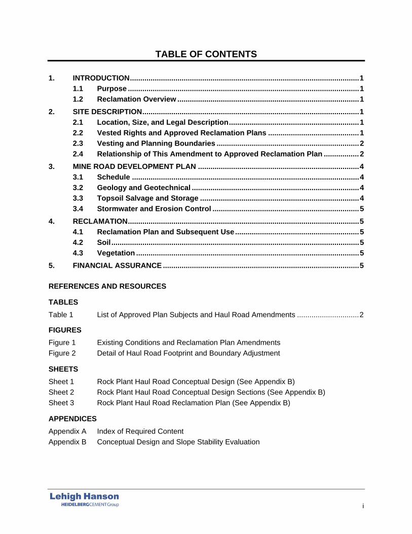
TABLE OF CONTENTS
1. INTRODUCTION ............................................................................................................... 1 1.1 Purpose ................................................................................................................ 1 1.2 Reclamation Overview ........................................................................................ 1
2. SITE DESCRIPTION ......................................................................................................... 1 2.1 Location, Size, and Legal Description ............................................................... 1 2.2 Vested Rights and Approved Reclamation Plans ............................................ 1 2.3 Vesting and Planning Boundaries ..................................................................... 2 2.4 Relationship of This Amendment to Approved Reclamation Plan ................. 2
3. MINE ROAD DEVELOPMENT PLAN .............................................................................. 4 3.1 Schedule .............................................................................................................. 4 3.2 Geology and Geotechnical ................................................................................. 4 3.3 Topsoil Salvage and Storage ............................................................................. 4 3.4 Stormwater and Erosion Control ....................................................................... 5
4. RECLAMATION ................................................................................................................ 5 4.1 Reclamation Plan and Subsequent Use ............................................................ 5 4.2 Soil ........................................................................................................................ 5 4.3 Vegetation ............................................................................................................ 5
5. FINANCIAL ASSURANCE ............................................................................................... 5
REFERENCES AND RESOURCES
TABLES Table 1 List of Approved Plan Subjects and Haul Road Amendments .............................. 2
FIGURES Figure 1 Existing Conditions and Reclamation Plan Amendments Figure 2 Detail of Haul Road Footprint and Boundary Adjustment
SHEETS Sheet 1 Rock Plant Haul Road Conceptual Design (See Appendix B) Sheet 2 Rock Plant Haul Road Conceptual Design Sections (See Appendix B) Sheet 3 Rock Plant Haul Road Reclamation Plan (See Appendix B)
APPENDICES Appendix A Index of Required Content Appendix B Conceptual Design and Slope Stability Evaluation

Name and Address of Owner/Operator
Hanson Permanente Cement, Inc. Lehigh Southwest Cement Company 24001 Stevens Creek Blvd Cupertino, California 95014 Contact: Erika Guerra Telephone: (408) 996-4269 E-mail: [email protected]
Name and Address of Agent
Lehigh Southwest Cement Company 24001 Stevens Creek Blvd Cupertino, California 95014 Contact: Erika Guerra Telephone: (408) 996-4269 E-mail: [email protected]
STATEMENT OF RECLAMATION RESPONSIBILITY I certify that the information in this reclamation plan is correct, to the best of my knowledge, and that all of the owners of possessory interest in the property in question have been notified of the planned operation and potential uses of the land after reclamation. I also certify that I am authorized on behalf of Lehigh Southwest Cement Company to accept responsibility for reclaiming the mined lands described and submitted herein, with any modification required by Santa Clara County and agreed to as conditions of approval.
Signed this ______ day of _________________, 2018. Erika Guerra for Lehigh Hanson, Inc. (Owner/Operator)
9 November

Permanente Quarry Rock Plant Haul Road Reclamation Reclamation Plan Amendment and Boundary Adjustment
1
1. INTRODUCTION
1.1 Purpose
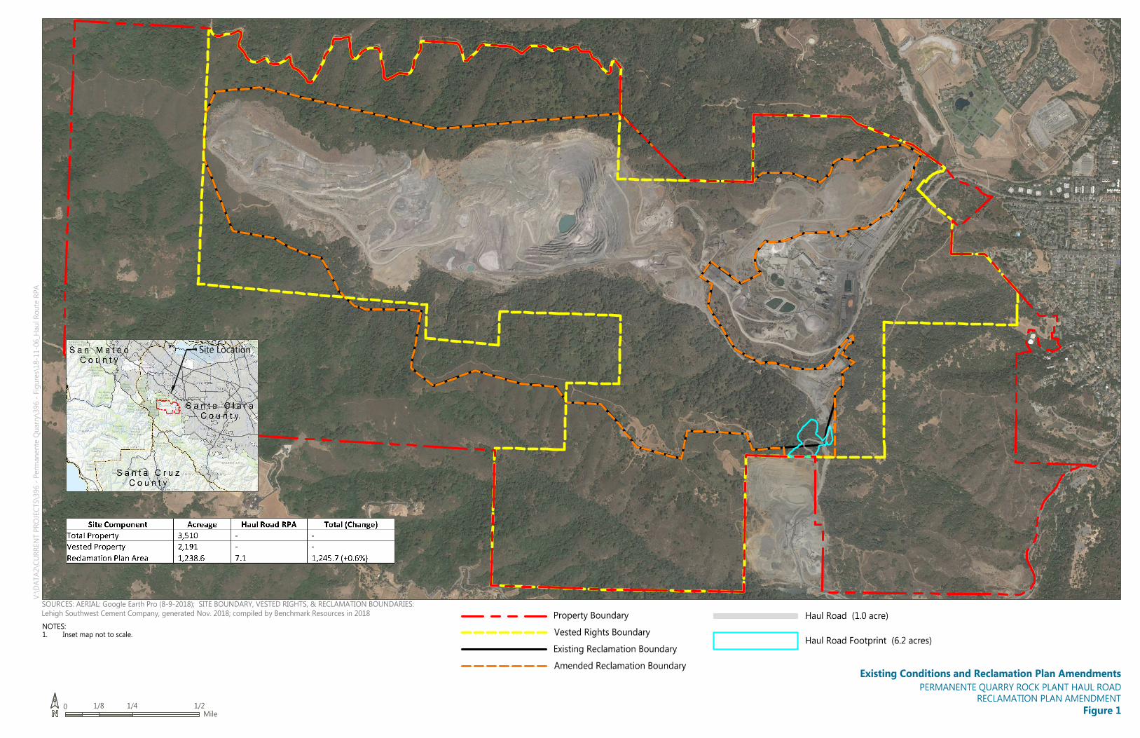
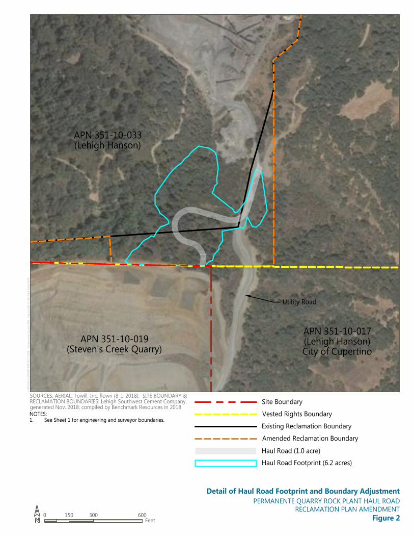
Lehigh Southwest Cement Company (Lehigh) has prepared this minor reclamation plan amendment (Minor Amendment) to amend the approved June 26, 2012, reclamation plan. The makes minor modifications to the reclamation plan to add 7.1 acres of land to the existing 1,238.6-acre reclamation plan boundary to incorporate a new haul road and an existing utility access road. The resulting reclamation plan boundary will encompass 1,245.7 acres. The additional mining-related disturbance incorporated within this area totals 7.2 acres. The Minor Amendment will not expand the area in which mineral deposits are harvested.
1.2 Reclamation Overview
The adjustment to the reclamation plan boundary will add 7.1 acres to the existing 1,238.6 reclamation plan boundary. The Rock Plant haul-road construction will involve approximately 7.2 acres of surface disturbance, of which 6.2 acres would be reclaimed at the completion of construction. The remaining approximately 1-acre area is the road surface, which will remain following mining operations to provide long-term access to the adjacent property. This use is consistent with the applicable land-use policies, zoning requirements, and approved reclamation plan’s postreclamation land condition suitable for open space uses.
The utility access road is a preexisting roadway that was previously limited to general-purpose access and utility company (currently Pacific Gas and Electric Company [PG&E]) access to power lines in the area. In spring 2018, the road was improved to support off-road haul trucks to transport aggregate material from the Permanente Quarry aggregate plant to the neighboring Stevens Creek Quarry. The County has directed Lehigh to cease using the road because the approved 2012 reclamation plan must be amended to include the haul road disturbance area. Lehigh stopped using the road for mining operations and installed a gate across the road’s southern end to prevent further use by haul trucks. The road will continue to be used only for intermittent light-duty vehicle access and utility company access (i.e., road use will revert to historical uses). Reclamation specifications applied to the haul-road construction are based on the provisions of the approved 2012 reclamation plan. Where site-specific standards apply, they are described in this amendment.
2. SITE DESCRIPTION
2.1 Location, Size, and Legal Description
The Permanente Quarry property includes 3,510 acres and 11 parcels. Of the total site acreage, 2,656 acres are subject to Santa Clara County’s (the “County’s”) land use jurisdiction (Santa Clara County 2011).
The subject haul road falls entirely within the 159.42-acre parcel (Accessor’s Parcel Number 351-10-033) located in the southeastern portion of the property and is within the County’s unincorporated jurisdiction. This parcel is vested and the majority of the parcel is currently within the reclamation plan boundaries. It is in an area of the site that has not been mined.
2.2 Vested Rights and Approved Reclamation Plans
Permanente Quarry is a “vested mine” operation, as determined following a County Board of Supervisors public hearing on February 8, 2011. The vested right, therefore, includes the right
Permanente Quarry Rock Plant Haul Road Reclamation Reclamation Plan Amendment and Boundary Adjustment
2
to continue operations within the vested rights. The planned haul road falls within this vested area.
The initial reclamation plan for Permanente Quarry was approved in 1985. It was comprehensively updated in 2012 to comply with all current standards under the California Surface Mining and Reclamation Act (SMARA). The approved plan provides for a postreclamation land condition suitable for open space uses. This use is consistent with the applicable land-use policies and zoning requirements.
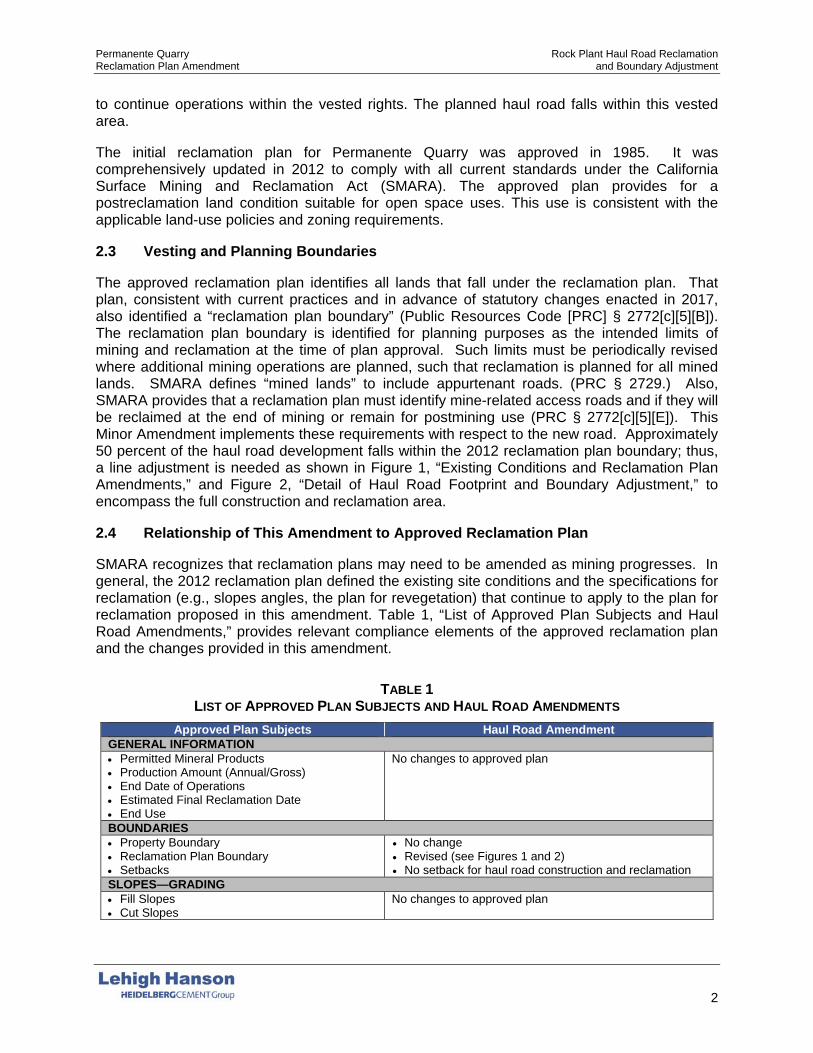
2.3 Vesting and Planning Boundaries
The approved reclamation plan identifies all lands that fall under the reclamation plan. That plan, consistent with current practices and in advance of statutory changes enacted in 2017, also identified a “reclamation plan boundary” (Public Resources Code [PRC] § 2772[c][5][B]). The reclamation plan boundary is identified for planning purposes as the intended limits of mining and reclamation at the time of plan approval. Such limits must be periodically revised where additional mining operations are planned, such that reclamation is planned for all mined lands. SMARA defines “mined lands” to include appurtenant roads. (PRC § 2729.) Also, SMARA provides that a reclamation plan must identify mine-related access roads and if they will be reclaimed at the end of mining or remain for postmining use (PRC § 2772[c][5][E]). This Minor Amendment implements these requirements with respect to the new road. Approximately 50 percent of the haul road development falls within the 2012 reclamation plan boundary; thus, a line adjustment is needed as shown in Figure 1, “Existing Conditions and Reclamation Plan Amendments,” and Figure 2, “Detail of Haul Road Footprint and Boundary Adjustment,” to encompass the full construction and reclamation area.
2.4 Relationship of This Amendment to Approved Reclamation Plan
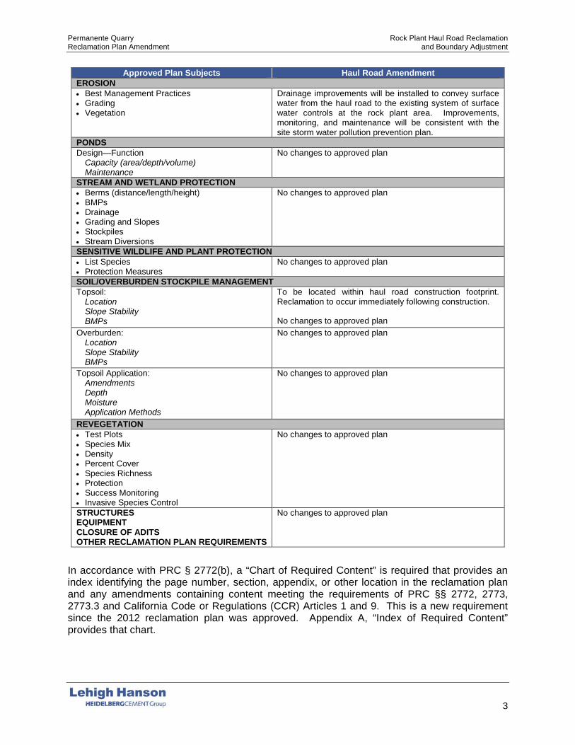
SMARA recognizes that reclamation plans may need to be amended as mining progresses. In general, the 2012 reclamation plan defined the existing site conditions and the specifications for reclamation (e.g., slopes angles, the plan for revegetation) that continue to apply to the plan for reclamation proposed in this amendment. Table 1, “List of Approved Plan Subjects and Haul Road Amendments,” provides relevant compliance elements of the approved reclamation plan and the changes provided in this amendment.
TABLE 1 LIST OF APPROVED PLAN SUBJECTS AND HAUL ROAD AMENDMENTS
Approved Plan Subjects Haul Road Amendment GENERAL INFORMATION • Permitted Mineral Products • Production Amount (Annual/Gross) • End Date of Operations • Estimated Final Reclamation Date • End Use
No changes to approved plan
BOUNDARIES • Property Boundary • Reclamation Plan Boundary • Setbacks
• No change • Revised (see Figures 1 and 2) • No setback for haul road construction and reclamation
SLOPES—GRADING • Fill Slopes • Cut Slopes
No changes to approved plan
Permanente Quarry Rock Plant Haul Road Reclamation Reclamation Plan Amendment and Boundary Adjustment
3
Approved Plan Subjects Haul Road Amendment EROSION • Best Management Practices • Grading • Vegetation
Drainage improvements will be installed to convey surface water from the haul road to the existing system of surface water controls at the rock plant area. Improvements, monitoring, and maintenance will be consistent with the site storm water pollution prevention plan.
PONDS Design—Function
Capacity (area/depth/volume) Maintenance
No changes to approved plan
STREAM AND WETLAND PROTECTION • Berms (distance/length/height) • BMPs • Drainage • Grading and Slopes • Stockpiles • Stream Diversions
No changes to approved plan
SENSITIVE WILDLIFE AND PLANT PROTECTION • List Species • Protection Measures
No changes to approved plan
SOIL/OVERBURDEN STOCKPILE MANAGEMENT Topsoil:
Location Slope Stability BMPs
To be located within haul road construction footprint. Reclamation to occur immediately following construction.
No changes to approved plan Overburden:
Location Slope Stability BMPs
No changes to approved plan
Topsoil Application: Amendments Depth Moisture Application Methods
No changes to approved plan
REVEGETATION • Test Plots • Species Mix • Density • Percent Cover • Species Richness • Protection • Success Monitoring • Invasive Species Control
No changes to approved plan
STRUCTURES EQUIPMENT CLOSURE OF ADITS OTHER RECLAMATION PLAN REQUIREMENTS
No changes to approved plan
In accordance with PRC § 2772(b), a “Chart of Required Content” is required that provides an index identifying the page number, section, appendix, or other location in the reclamation plan and any amendments containing content meeting the requirements of PRC §§ 2772, 2773, 2773.3 and California Code or Regulations (CCR) Articles 1 and 9. This is a new requirement since the 2012 reclamation plan was approved. Appendix A, “Index of Required Content” provides that chart.
Permanente Quarry Rock Plant Haul Road Reclamation Reclamation Plan Amendment and Boundary Adjustment
4
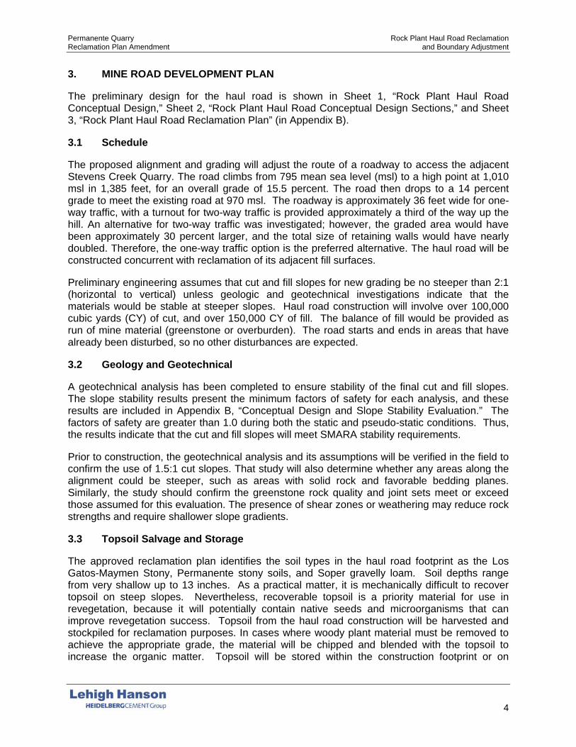
3. MINE ROAD DEVELOPMENT PLAN
The preliminary design for the haul road is shown in Sheet 1, “Rock Plant Haul Road Conceptual Design,” Sheet 2, “Rock Plant Haul Road Conceptual Design Sections,” and Sheet 3, “Rock Plant Haul Road Reclamation Plan” (in Appendix B).
3.1 Schedule
The proposed alignment and grading will adjust the route of a roadway to access the adjacent Stevens Creek Quarry. The road climbs from 795 mean sea level (msl) to a high point at 1,010 msl in 1,385 feet, for an overall grade of 15.5 percent. The road then drops to a 14 percent grade to meet the existing road at 970 msl. The roadway is approximately 36 feet wide for one-way traffic, with a turnout for two-way traffic is provided approximately a third of the way up the hill. An alternative for two-way traffic was investigated; however, the graded area would have been approximately 30 percent larger, and the total size of retaining walls would have nearly doubled. Therefore, the one-way traffic option is the preferred alternative. The haul road will be constructed concurrent with reclamation of its adjacent fill surfaces.
Preliminary engineering assumes that cut and fill slopes for new grading be no steeper than 2:1 (horizontal to vertical) unless geologic and geotechnical investigations indicate that the materials would be stable at steeper slopes. Haul road construction will involve over 100,000 cubic yards (CY) of cut, and over 150,000 CY of fill. The balance of fill would be provided as run of mine material (greenstone or overburden). The road starts and ends in areas that have already been disturbed, so no other disturbances are expected.
3.2 Geology and Geotechnical
A geotechnical analysis has been completed to ensure stability of the final cut and fill slopes. The slope stability results present the minimum factors of safety for each analysis, and these results are included in Appendix B, “Conceptual Design and Slope Stability Evaluation.” The factors of safety are greater than 1.0 during both the static and pseudo-static conditions. Thus, the results indicate that the cut and fill slopes will meet SMARA stability requirements.
Prior to construction, the geotechnical analysis and its assumptions will be verified in the field to confirm the use of 1.5:1 cut slopes. That study will also determine whether any areas along the alignment could be steeper, such as areas with solid rock and favorable bedding planes. Similarly, the study should confirm the greenstone rock quality and joint sets meet or exceed those assumed for this evaluation. The presence of shear zones or weathering may reduce rock strengths and require shallower slope gradients.
3.3 Topsoil Salvage and Storage
The approved reclamation plan identifies the soil types in the haul road footprint as the Los Gatos-Maymen Stony, Permanente stony soils, and Soper gravelly loam. Soil depths range from very shallow up to 13 inches. As a practical matter, it is mechanically difficult to recover topsoil on steep slopes. Nevertheless, recoverable topsoil is a priority material for use in revegetation, because it will potentially contain native seeds and microorganisms that can improve revegetation success. Topsoil from the haul road construction will be harvested and stockpiled for reclamation purposes. In cases where woody plant material must be removed to achieve the appropriate grade, the material will be chipped and blended with the topsoil to increase the organic matter. Topsoil will be stored within the construction footprint or on

Permanente Quarry Rock Plant Haul Road Reclamation Reclamation Plan Amendment and Boundary Adjustment
5
established mine surfaces. It will be marked and protected for use in haul road fill slope reclamation. Some of the topsoil could be directly hauled and placed.
3.4 Stormwater and Erosion Control
Stormwater and erosion controls during construction of the haul road would be consistent with the approved reclamation plan (see Attachment F of the approved reclamation plan) and current storm water pollution prevention plan. Stormwater will generally be contained to the road by ditches and MSHA berms, and it will flow into the existing stormwater management systems. Best management practices include use of straw wattles, drainage channels, swales, silt fencing, revegetation, monitoring, and maintenance.
4. RECLAMATION
4.1 Reclamation Plan and Subsequent Use
The reclamation areas of the haul-road footprint are indicated on Sheet 3. The exposed cut and fill areas created on either side of the utility access roadway during road improvements will be hydroseeded.
The Rock Plant haul road will connect adjacent properties and is a property improvement that will therefore remain following reclamation of this area and the overall quarry. The roadway is located on private properties and is not intended for public use. Long-term safety is integrated into the engineered design for stability.
4.2 Soil
Salvaged soil will be placed on the graded and compacted fill surfaces adjacent to the haul road. The depth of soil placed will depend on the amount recovered from the steep slopes. Assuming 6 inches of growth media cover, reclamation would require approximately 4,920 CY.
4.3 Vegetation
Reclamation treatments shall consist of revegetation, erosion control best management practices, monitoring, and maintenance as specified in the approved reclamation plan. For both roads, revegetation will consist of the general hydroseeding mix listed in Table 4 of the approved reclamation plan. This seed mix will be applied to exposed areas of cut and fill created on either side of the utility access roadway during road improvements, and to exposed cut and fill areas created during construction of the haul road.
Hydroseeding would occur pursuant to the timing requirements in the reclamation plan, generally between September 1 and December 1 in the first year following road development. Should road development occur after December 1 but before the end of the rainy season, hydroseeding will occur immediately.
Revegetation monitoring and maintenance would be consistent with the approved reclamation plan.
5. FINANCIAL ASSURANCE
Permanente Quarry has an existing financial assurance posted with Santa Clara County and the Division of Mine Reclamation in the amount of $53,861,976. This haul road reclamation plan amendment will result in an additional 6.2 acres of surfaces requiring the following tasks:
Permanente Quarry Rock Plant Haul Road Reclamation Reclamation Plan Amendment and Boundary Adjustment
6
• Fill and grading: – Place growth media over final surfaces.
• Revegetation: – Seed final surfaces.
• Monitoring/maintenance: – Inspect revegetation surfaces. – Implement maintenance tasks and weeding, as needed. – Create a replanting contingency.
Financial assurance for these tasks will be calculated subsequent to approval of this reclamation plan amendment. The County reviews financial assurances annually. They are adjusted, if necessary, to reflect changes in the estimated cost of reclamation activities and lands reclaimed the previous year.

FIGURES

APPENDICES

APPENDIX A INDEX OF REQUIRED CONTENT

A-1
APPENDIX A INDEX TO REQUIRED CONTENT
Mine Name: Permanente Quarry
Amendments: Rock Plant Haul Road Reclamation and Boundary Adjustment (RPA)
Reclamation Plan:
Permanente Quarry Reclamation Plan Amendment (approved 2012) (RP)
End Use: Open space Date: 2018
Authority Requirements/Practices/Standards Applicable Source/Page or
Explanation GENERAL CONSIDERATIONS
PRC 2772(b)
Required contents chart: A chart identifying the location (e.g. page number, chapter, appendix, or other location in the reclamation plan) of content that meets the requirements of PRC Sections 2772, 2773, 2773.3 and CCR Articles 1 and 9 (as delineated in this checklist).
X This table
PRC 2772(c)(1)
Contact information: Name and address of the surface mining operator and any person designated by the operator as an agent for service of process (must reside in CA).
X RP: Section 3.1,
pg. 25 RPA: pg. ii
PRC 2772(c)(2)
Material quantity and type: The anticipated total quantity and type of minerals to be mined (see Annual Report Instructions, Exhibit B, for mineral types and units of measure).
X RP: Section 3.2, pg. 25
PRC 2772(c)(3) Dates: The initiation and termination dates of mining (be as specific as possible, e.g. December 31, 2030).
X RP: Section 3.2, pg. 25
PRC 2772(c)(4)
Depth of mining: The maximum anticipated depth of surface mining in relation to a verifiable benchmark such as Mean Sea Level.
X RP: Section 3.2, pg. 26
PRC 2772(c)(5) (A-F)
Reclamation plan maps shall include: Size and legal description of lands affected by surface mining operations;
X
RP: Attachment A;
Figure 1.0-4, pg. 5
Names and addresses of owners of all surface interests and mineral interests; X
RP: Section 3.1, pg. 25
RPA: pg. ii Property lines, setbacks, and the reclamation plan boundary; X RP: Figures 1.0-
5, 1.0-6, pgs. 6–7
Existing and final topography with contour lines at appropriate intervals; X
RP: Existing—RP: Figure 2.7-1, Final—3.61-14
Detailed geologic description of the area of the surface mining operation; X RP: Figure 2.6-1,
pg. 22 Locations of railroads, utility features, and roads (access roads, temporary roads to be reclaimed, and any roads remaining for the end use).
X RP: Figure 3.13-1, pg. 39
All maps, diagrams, or calculations that are required to be prepared by a California-licensed professional shall include the preparer’s name, license number, signature & seal.
X
RP: Not applicable in
2012 RPA: Sheets 1–3

Permanente Quarry Rock Plant Haul Road Reclamation Reclamation Plan Amendment and Boundary Adjustment Appendix A Index to Required Content
A-2
Authority Requirements/Practices/Standards Applicable Source/Page or
Explanation
PRC 2772(c)(6)
Mining method and schedule: A description of the mining methods and a time schedule that provides for completion of mining on each segment so that reclamation can be concurrent or phased.
X RP: Section 3.3, page 26; Section
3.16, pg. 43
PRC 2772(c)(7)
Subsequent use(s): A description of the proposed subsequent use(s) after reclamation
X RP: Section 3.15, page 40
Evidence that all landowners have been notified of the proposed use. X RPA: Pg.iv
PRC 2772(c)(9) Impact on future mining: A statement regarding the impact of reclamation on future mining on the site.
X RP: Section 3.22, pg. 104
PRC 2772(c)(10)
Signed statement: Statement signed by the operator accepting responsibility for reclamation of the mined lands per the reclamation plan.
X RP: Pg. 105 RPA: Pg.ii
PRC 2776(b-c)
Pre-SMARA areas: Reclamation plans shall apply to operations conducted after January 1, 1976 or to be conducted in the future. Mined lands disturbed prior to January 1, 1976 and not disturbed after that date may be excluded from the reclamation plan.
X RP: Section 3.3, pg. 28; Section
3.16, pg. 80
CCR 3502(b)(2)
Public health and safety: A description of how any potential public health and safety concerns that may arise due to exposure of the public to the site will be addressed.
X
RP: Section 3.5, pg. 31; Section
3.11, pg. 37; Section 3.21, pg.
104
CCR 3709(a)
Equipment storage and waste disposal: Designate areas for equipment storage and show on maps.
X
RP: Figures 3.3-1, pg. 29; 3.3-2, pg. 30; 3.7-1, pg. 34; 3.7-2, pg. 35; 3.7-3 pg. 36;
3.16-12, pg. 58; Waste: Figure 3.3-1, pg. 29
All waste shall be disposed of in accordance with state and local health and safety ordinances. X RP: Section 3.20,
pg. 104
CCR 3709(b)
Structures and equipment removed: Structures and equipment should be dismantled and removed at closure, except as demonstrated to be necessary for the proposed end use.
X RP: Section 3.20, pg. 104
CCR 3713(a)
Well closures: Drill holes, water wells, monitoring wells will be completed or abandoned in accordance with laws, unless demonstrated necessary for the proposed end use.
X RP: 3.20, pg. 104

Permanente Quarry Rock Plant Haul Road Reclamation Reclamation Plan Amendment and Boundary Adjustment Appendix A Index to Required Content
A-3
Authority Requirements/Practices/Standards Applicable Source/Page or
Explanation
CCR 3713(b)
Underground openings: Any portals, shafts, tunnels, or openings will be gated or protected from public entry, and to preserve access for wildlife (e.g. bats).
X RP: Section 3.15, pg. 46 (conveyor
tunnel)
GEOLOGY AND GEOTECHNICAL
PRC 2772(c)(5)
A description of the general geology of the area X RP: Section 2.5, pg. 9
A detailed description of the geology of the mine site. X RP: Section 2.5,
pg. 9; Attachment C
PRC 2773.3
If a metallic mine is located on, or within one mile of, any “Native American sacred site” and is located in an “area of special concern, ” the reclamation plan shall require that all excavations and/or excess materials be backfilled and graded to achieve the approximate original contours of the mined lands prior to mining.
— Not applicable (NA)
CCR 3502(b)(4)
The source and disposition of fill materials used for backfilling or grading shall be considered in the reclamation plan. X
RP: Section 3.17.2, pg. 62
RPA: Section 3.2, pg. 4
CCR 3502(b)(3)
The designed steepness and treatment of final slopes must consider the physical properties of slope materials, maximum water content, and landscaping.
X
RP: Section 3.17.2, pg. 62; Attachment C
RPA: Section 3.2, pg. 4
The reclamation plan shall specify slope angles flatter than the critical gradient for the type of slope materials. X
RP: Section 3.17.2, pg. 62; Attachment C
RPA: Section 3.2, pg. 4
When final slopes approach the critical gradient, a Slope Stability Analysis will be required. X
RP: Section 3.17.2, pg. 62; Attachment C
RPA: Section 3.2, pg. 4
CCR 3704.1 Backfilling required for surface mining operations for metallic minerals. — NA
CCR 3704(a) For urban use, fill shall be compacted in accordance with Uniform Building Code, local grading ordinance, or other methods approved by the lead agency.
— NA
CCR 3704(b) For resource conservation, compact to the standards required for that end use. X RP: Attachment
C
CCR 3704(d)
Final reclamation fill slopes shall not exceed 2:1 (H:V), except when allowed by site-specific engineering analysis, and the proposed final slope can be successfully revegetated. See also Section 3502(b)(3).
X
RP: Section 3.17.2, pg. 62; Attachment C
RPA: Section 3.2, pg. 4
CCR 3704(e)
At closure, all fill slopes shall conform with the surrounding topography or approved end use. X
RP: Section 3.17.2, pg. 62; Figure 3.16-13,
pg. 59

Permanente Quarry Rock Plant Haul Road Reclamation Reclamation Plan Amendment and Boundary Adjustment Appendix A Index to Required Content
A-4
Authority Requirements/Practices/Standards Applicable Source/Page or
Explanation
CCR 3704(f)
Final cut slopes must have a minimum slope stability factor of safety that is suitable for the end use and conforms with the surrounding topography or end use. X
RP: Section 3.17.2, pg. 62; Figure 3.16-13,
pg. 59 RPA: Section 3.2,
pg. 4 HYDROLOGY AND WATER QUALITY
PRC 2770.5
For operations within the 100-year flood plain (defined by FEMA) and within one mile up- or downstream of a state highway bridge, Caltrans must be notified and provided a 45-day review period by the lead agency.
— NA
PRC 2772(c)(8)(A) Description of the manner in which contaminants will be controlled and mine waste will be disposed. X RP: Section 3.15,
pg. 40
PRC 2772(c)(8)(B) The reclamation plan shall include a description of the manner in which stream banks/beds will be rehabilitated to minimize erosion and sedimentation.
X RP: 3.19, pg. 80
PRC 2773(a) The reclamation plan shall establish site-specific sediment and erosion control criteria for monitoring compliance with the reclamation plan.
RP: Section 3.9, pg. 37; Section
3.18, pg. 76; Attachment F
CCR 3502(b)(6) Temporary stream and watershed diversions shall be detailed in the reclamation plan. X RP: 3.19, pg. 80
CCR 3503(a)(2) Stockpiles of overburden and minerals shall be managed to minimize water and wind erosion. X RP: Section
3.17.3.1, pg. 65
CCR 3503(b)(2) Operations shall be conducted to substantially prevent siltation of groundwater recharge areas. X
RP: Section 3.9, pg. 37; Section
3.18, pg. 76; Attachment E, F
CCR 3503(a)(3) Erosion control facilities shall be constructed and maintained where necessary to control erosion. X
RP: Section 3.9, pg. 37; Section
3.18, pg. 76; Attachment F
CCR 3503(b)(1) Settling ponds shall be constructed where they will provide a significant benefit to water quality. X
RP: Section 3.9, pg. 37; Section
3.18, pg. 76; Attachment F
CCR 3503(d) Disposal of mine waste and overburden shall be stable and shall not restrict natural drainage without suitable provisions for diversion.
X
RP: Section 3.9, pg. 37; Section
3.18, pg. 76; Attachment F
CCR 3503(e)
Grading and revegetation shall be designed to minimize erosion and convey surface runoff to natural drainage courses or interior basins.
X
RP: Section 3.9, pg. 37; Section
3.18, pg. 76; Attachment F
Spillway protection shall be designed to prevent erosion. X RP: Section 3.18,
pg. 76; Attachment F
CCR 3706(a) Surface mining and reclamation activities shall be conducted to protect on-site and downstream beneficial uses of water.
X
RP: Section 2.8, pg. 15; RP:
Section 3.18, pg. 76; Attachment F

Permanente Quarry Rock Plant Haul Road Reclamation Reclamation Plan Amendment and Boundary Adjustment Appendix A Index to Required Content
A-5
Authority Requirements/Practices/Standards Applicable Source/Page or
Explanation
CCR 3706(b) Water quality, recharge potential, and groundwater storage that is accessed by others shall not be diminished.
X
RP: Section 2.8, pg. 15; RP:
Section 3.18, pg. 76; Attachment F
CCR 3706(c)
Erosion and sedimentation shall be controlled during all phases of construction, operation, reclamation, and closure of surface mining operations to minimize siltation of lakes and water courses as per RWQCB/SWRCB.
X
RP: Section 3.9, pg. 37; Section
3.18, pg. 76; Attachment F
CCR 3706(d)
Surface runoff and drainage shall be controlled to protect surrounding land and water resources. X
RP: Section 3.9, pg. 37; Section
3.18, pg. 76; Attachment F
Erosion control methods shall be designed for not less than 20 year/1 hour intensity storm event. X
RP: Section 3.9, pg. 37; Section
3.18, pg. 76; Attachment F
CCR 3706(e) Impacted drainages shall not cause increased erosion or sedimentation. Mitigation alternatives shall be proposed in the reclamation plan.
X
RP: Section 3.9, pg. 37; Section
3.18, pg. 76; Attachment F
CCR 3706(f)(1)
Stream diversions shall be constructed in accordance with the Lake and Streambed Alteration Agreement (LSAA) between the operator and the Department of Fish and Wildlife.
X RP: 3.19, pg. 80
CCR 3706(f)(2) Stream diversions shall also be constructed in accordance with Federal Clean Water Act and the Rivers and Harbors Act of 1899.
X RP: 3.19, pg. 80
CCR 3706(g) All temporary stream diversions shall eventually be removed and the affected land reclaimed. X RP: 3.19, pg. 80
CCR 3710(a)
Surface and groundwater shall be protected from siltation and pollutants in accordance with the Porter-Cologne Act, the Federal Clean Water Act, and RWQCB/SWRCB requirements.
X
RP: Section 3.9, pg. 37; Section
3.18, pg. 76; Attachment F
CCR 3710(b)
In-stream mining shall be conducted in accordance with Section 1600 et seq. of the California Fish and Game Code, Section 404 of the Clean Water Act, and Section 10 of the Rivers and Harbors Act of 1899.
— NA
CCR 3710(c)
In-stream mining shall be regulated to prevent impacts to structures, habitats, riparian vegetation, groundwater levels, and banks.
— NA
In-stream channel elevations and bank erosion shall be evaluated annually using extraction quantities, cross-sections, and aerial photos.
— NA
CCR 3712
Mine waste and tailings and mine waste disposal units are governed by SWRCB waste disposal regulations and shall be reclaimed in accordance with this article: CCR Article 1. Surface Mining and Reclamation Practice. Section 3500 et seq.
X RP: Section 3.15, pg. 40

Permanente Quarry Rock Plant Haul Road Reclamation Reclamation Plan Amendment and Boundary Adjustment Appendix A Index to Required Content
A-6
Authority Requirements/Practices/Standards Applicable Source/Page or
Explanation SENSITIVE SPECIES AND HABITAT
CCR 3502(b)(1)
A description of the environmental setting (identify sensitive species, wildlife habitat, sensitive natural communities, e.g. wetlands).
X RP: Section 2.9,
pg. 15, Attachment D
Impacts of reclamation on surrounding land uses. X RP: Section 2.3, pg. 8
CCR 3503(c) Fish and wildlife habitat shall be protected by all reasonable measures. X
RP: Section 3.17.1, pg. 61, Attachment D
CCR 3703(a) Sensitive species shall be conserved or mitigated as prescribed by the federal and California Endangered Species Acts.
X RP: Section
3.17.1, pg. 61, Attachment D
CCR 3703(b) Wildlife habitat shall be established on disturbed land at least as good as pre-project, unless end use precludes its use as wildlife habitat.
— NA
CCR 3703(c) Wetlands shall be avoided or mitigated at 1:1 minimum for both acreage and habitat value. X
RP: Section 3.17.1, Section 18, pg. 76; pg.
61, Attachment D
CCR 3704(g) Piles or dumps shall not be placed in wetlands without mitigation. X
RP: Section 3.15, pg. 40; Section 3.17.3.1, pg. 65
CCR 3710(d) In-stream mining shall not cause fish to be trapped in pools or off-channel pits, or restrict migratory or spawning activities.
— NA
TOPSOIL
CCR 3503(a)(1) Removal of vegetation and overburden preceding mining shall be kept to a minimum. X RP: Section 3.4,
pg. 31
CCR 3503(f)
When the reclamation plan calls for resoiling, mine waste shall be leveled and covered with a layer of finer material. A soil layer shall then be placed on this prepared surface.
X
RP: Section 3.17.3, pg. 64; Attachment B
RPA: Section 3.3, pg. 4
The use of soil conditioners, mulches, or imported topsoil shall be considered where such measures appear necessary.
X RP: Section
3.17.3, pg. 64; Attachment B
CCR 3704(c) Mine waste shall be stockpiled to facilitate phased reclamation and kept separate from topsoil or other growth media.
X
RP: Section 3.17.3, pg. 64; Attachment B;
Section 3.16, pg. 43
CCR 3705(e) If soil is altered or other than native topsoil, soil analysis is required. Add fertilizers or soil amendments if necessary.
X RP: Section
3.17.3, pg. 64; Attachment B
CCR 3711(a) All salvageable topsoil shall be removed as a separate layer. X
RP: Section 3.17.3, pg. 64; Attachment B
RPA: Section 3.3, pg. 4

Permanente Quarry Rock Plant Haul Road Reclamation Reclamation Plan Amendment and Boundary Adjustment Appendix A Index to Required Content
A-7
Authority Requirements/Practices/Standards Applicable Source/Page or
Explanation
CCR 3711(a) (continued from above)
Topsoil and vegetation removal should not precede mining by more than one year. X
RP: Section 3.4, pg. 31,
Attachment B
CCR 3711(b)
Topsoil resources shall be mapped prior to stripping and location of topsoil stockpiles shown on map included in the reclamation plan.
X
RP: Section 3.4, pg. 31, Section 3.17.3, pg. 64; Attachment B
Topsoil and other growth media shall be maintained in separate stockpiles. X
RP: Section 3.4, pg. 31, Section 3.17.3, pg. 64; Attachment B
RPA: Section 3.3, pg. 4
Test plots may be required to determine the suitability of growth media for revegetation purposes. X RP: Section
3.17.3.3, pg. 72
CCR 3711(c)
Soil salvage operations and phases of reclamation shall be set forth in the reclamation plan to minimize the area disturbed and to achieve maximum revegetation success.
X
RP: Section 3.4, pg. 31; Section 3.17.3, pg. 64; Attachment B
RPA: Section 3.3, pg. 4
CCR 3711(d)
Topsoil and growth media shall be used to phase reclamation as soon as can be accommodated following the mining of an area.
X
RP: Section 3.4, pg. 31; Section
3.16, pg. 43; Section 3.17.3,
pg. 64; Attachment B
RPA: Section 3.3, pg. 4, Section
4.2, pg. 5
Topsoil stockpiles shall not be disturbed until needed for reclamation. X
RP: Section 3.4, pg. 31; Section 3.17.3, pg. 64; Attachment B
Topsoil stockpiles shall be clearly identified with signs. X
RP: Section 3.4, pg. 31; Section 3.17.3, pg. 64; Attachment B
Topsoil shall be planted with vegetation or otherwise protected to prevent erosion and discourage weeds. X
RP: Section 3.4, pg. 31; Section 3.17.3, pg. 64; Attachment B
CCR 3711(e) Topsoil shall be redistributed in a manner resulting in a stable, uniform thickness consistent with the end use. X
RP: Section 3.4, pg. 31; Section 3.17.3, pg. 64; Attachment B

Permanente Quarry Rock Plant Haul Road Reclamation Reclamation Plan Amendment and Boundary Adjustment Appendix A Index to Required Content
A-8
Authority Requirements/Practices/Standards Applicable Source/Page or
Explanation REVEGETATION
PRC 2773(a)
The reclamation plan shall be specific to the property and shall establish site-specific criteria for evaluating compliance with the reclamation plan with respect to revegetation.
X
RP: Section 3.17.3, pg. 64; Attachment B
RPA: Section 4.3, pg. 5
CCR 3503(g)
Available research regarding revegetation methods and selection of species given the topography, resoiling characteristics, and climate of the mined areas shall be used.
X
RP: Section 3.17.3, pg. 64; Attachment B
RPA: Section 4.3, pg. 5
CCR 3705(a)
Baseline studies shall be conducted prior to mining activities to document vegetative cover, density, and species richness.
X RP: Section
3.17.3, pg. 64; Attachment B
Vegetative cover shall be similar to surrounding habitats and self-sustaining. X
RP: Section 3.17.3, pg. 64; Attachment B
RPA: Section 4.3, pg. 5
CCR 3705(b) Test plots shall be conducted simultaneously with mining to ensure successful implementation of the proposed revegetation plan.
X RP: Section
3.17.3, pg. 64; Attachment B
CCR 3705(c) Decompaction methods, such as ripping and disking, shall be used in areas to be revegetated to establish a suitable root zone for planting.
X RP: Section
3.17.3, pg. 64; Attachment B
CCR 3705(d) Roads shall be stripped of roadbase materials, resoiled, and revegetated, unless exempted. X RP: Section 3.15,
pg. 40
CCR 3705(f)
Temporary access shall not disrupt the soil surface on arid lands except where necessary for safe access. Barriers shall be installed to keep unauthorized vehicles out.
X
RP: Section 3.15, pg. 40; Section 3.17.3, pg. 64; Attachment B
CCR 3705(g)
Use local native plant species (unless non-native species meet the end use). X
RP: Section 3.17.3, pg. 64; Attachment B
RPA: Section 4.3, pg. 5
Areas to be developed for industrial, commercial, or residential shall be revegetated for the interim period to control erosion.
— NA
CCR 3705(h) Planting shall be conducted during the most favorable period of the year for plant establishment. X
RP: Section 3.17.3, pg. 64; Attachment B
RPA: Section 4.3, pg. 5
CCR 3705(i) Use soil stabilizing practices and irrigation when necessary to establish vegetation. X RP: Section 3.18,
pg. 76
CCR 3705(j) If irrigation is used, demonstrate that revegetation has been self-sustaining without irrigation for two years prior to the release of financial assurance.
X RP: Section
3.17.3, pg. 64; Attachment B

Permanente Quarry Rock Plant Haul Road Reclamation Reclamation Plan Amendment and Boundary Adjustment Appendix A Index to Required Content
A-9
Authority Requirements/Practices/Standards Applicable Source/Page or
Explanation
CCR 3705(k) Weeds shall be monitored and managed. X RP: Section
3.17.3, pg. 64; Attachment B
CCR 3705(l)
Plant protection measures such as fencing and caging shall be used where needed for revegetation success. Protection measures shall be maintained until revegetation efforts are successfully completed and the lead agency authorizes removal.
X RP: Section
3.17.3, pg. 64; Attachment B
CCR3705(m)
Quantitative success standards for vegetative cover, density, and species richness shall be included in the reclamation plan.
X RP: Section
3.17.3, pg. 64; Attachment B
Monitoring to occur until success standards have been achieved. X
RP: Section 3.17.3, pg. 64; Attachment B
Sampling techniques for measuring success shall be specified. Sample size must be sufficient to provide at least an 80 percent statistical confidence level.
X RP: Section
3.17.3, pg. 64; Attachment B
AGRICULTURE
CCR 3707(a) Where the end use will be agriculture, prime agricultural land shall be returned to a fertility level specified in the reclamation plan.
— NA
CCR 3707(b) Segregate and replace topsoil in proper sequence by horizon in prime agricultural soils. — NA
CCR 3707(c)
Post reclamation productivity rates for prime agricultural land must be equal to pre-project condition or to a similar site for two consecutive years.
— NA
Productivity rates shall be specified in the reclamation plan. — NA
CCR 3707(d) If fertilizers and amendments are applied, they shall not cause contamination of surface or groundwater. X RP: Attachment
B
CCR 3708
For sites where the end use is to be agricultural, non-prime agricultural land must be reclaimed to be capable of sustaining economically viable crops common to the area.
— NA

APPENDIX B CONCEPTUAL DESIGN
AND SLOPE STABILITY EVALUATION

Technical Memo
To: Talia Flagan From: Paul S. Carey Lehigh Hanson San Bernardino CA Office File: Stevens Creek Quarry Access Road
Stantec PN 233001289 Date: October 19, 2018
Preliminary Alignment Stevens Creek Quarry Access Road
Background
The Stevens Creek Quarry is currently accessed by a roadway that climbs southerly from the Permanente aggregate plant and continues along a ridge toward the neighboring Stevens Creek Quarry property. The alignment has been in use for 50 plus years and does not represent an engineered design. This roadway began as a narrow, bulldozed exploration road, and recently was modified to allow for use by 45-ton off-highway haul trucks. Recently Stevens Creek Quarry has been picking up rock at the Lehigh aggregate plant and transporting it to their crushing facility on this road.
It has recently been discovered that the current alignment crosses into the jurisdictional boundary of the City of Cupertino as well as crossing outside of the current Reclamation Permit Boundary on file with Santa Clara County. Permanente quarry operations do not include entitlement to operate within the City of Cupertino. In addition, a Notice of Violation (NOV) was issued during a SMARA inspection directing Lehigh to seek alternative alignment or modify the current reclamation permit boundary. Lehigh Hanson contracted Stantec to design a road that meets current mining standards and does not cross the jurisdictional boundary of the City of Cupertino. This design memorandum includes the design criteria and conceptual design of a realigned road from the Permanente Quarry to the Stevens Creek Quarry.
Design Criteria
Compared to the existing access road, the haul road alignment will be shifted to the west from its current alignment. The upper portion of this alignment will be climbing an existing hillside that rises at a rate of 1 foot vertically for every 1.5 feet of horizontal distance traveled (referred to as a 1.5:1 slope). For most cases, preliminary engineering would assume that cut and fill slopes for new grading be no steeper than 2:1 unless geologic and geotechnical investigations indicate that the materials would be stable at steeper slopes. Given that the natural slope is at a 1.5:1 inclination and cut slopes throughout the site are generally stable at slopes with gradients steeper or equal to a 1.5:1 inclination, we are assuming that 1.5:1 slope is stable (see recommendations for further geotechnical investigation below). To enhance slope stability and limit erosion potential, a bench was added to slopes with heights greater than 200 feet. Fill slopes will be designed at the standard 2:1 inclination.
The proposed roadway will be utilized primarily by 45-ton off-highway articulated haul trucks transporting material from Lehigh’s aggregate plant to the Stevens Creek operation. For this design, the Caterpillar 745C articulated truck will be used as the representative vehicle. The figure below shows the dimensions of this vehicle:

October 19, 2018 Talia Flagan Page 2 of 7
Preliminary Alignment Stevens Creek Quarry Access Road

October 19, 2018 Talia Flagan Page 3 of 7
Preliminary Alignment Stevens Creek Quarry Access Road
And the following figure shows the turning radius and wheel tracking for this vehicle:
To accommodate this vehicle, we assume that the clear road width will need to be 42 feet for two-way traffic, and 24 feet for one-way traffic. These road widths are consistent with Mine Safety and Health Administration (MSHA) regulations, which require one-half the truck width on each side of the road and between the lanes. The trucks are approximately 12 feet wide.
MSHA regulations for mining roads also require that safety berms or guardrails be provided and maintained on the banks of roadways where a drop-off of sufficient grade or depth exists that could cause a vehicle to overturn or endanger persons in equipment. Berms or guardrails are required to be at least mid-axel height of the largest self-propelled mobile equipment which usually travels the roadway. For the design vehicle, the safety berms would be 3 feet in height, and an additional 6-feet in road width will be provided where downslope conditions exist.
Maximum road grade is assumed to be 20%, but ideally should be less where possible.
The above table indicates that the design vehicle has an inside turning radius of about 15-feet, with a drive aisle width of about 20-feet. For purposes of this design, we will assume that roadway curve radii of 100-feet can be implemented without widening of the roadway. Any tighter curves will require widening to allow for the expected wheel tracking.
Proposed Roadway Alignment and Grading
The attached exhibit shows the proposed alignment and grading for a roadway to access the Stevens Creek Quarry. The road climbs from an elevation of 795 to a high point at elevation 1010 over a length of 1,385 feet, for an overall grade of 15.5%. The road then drops at a 14% grade to meet the existing road at elevation 970.
October 19, 2018 Talia Flagan Page 4 of 7
Preliminary Alignment Stevens Creek Quarry Access Road
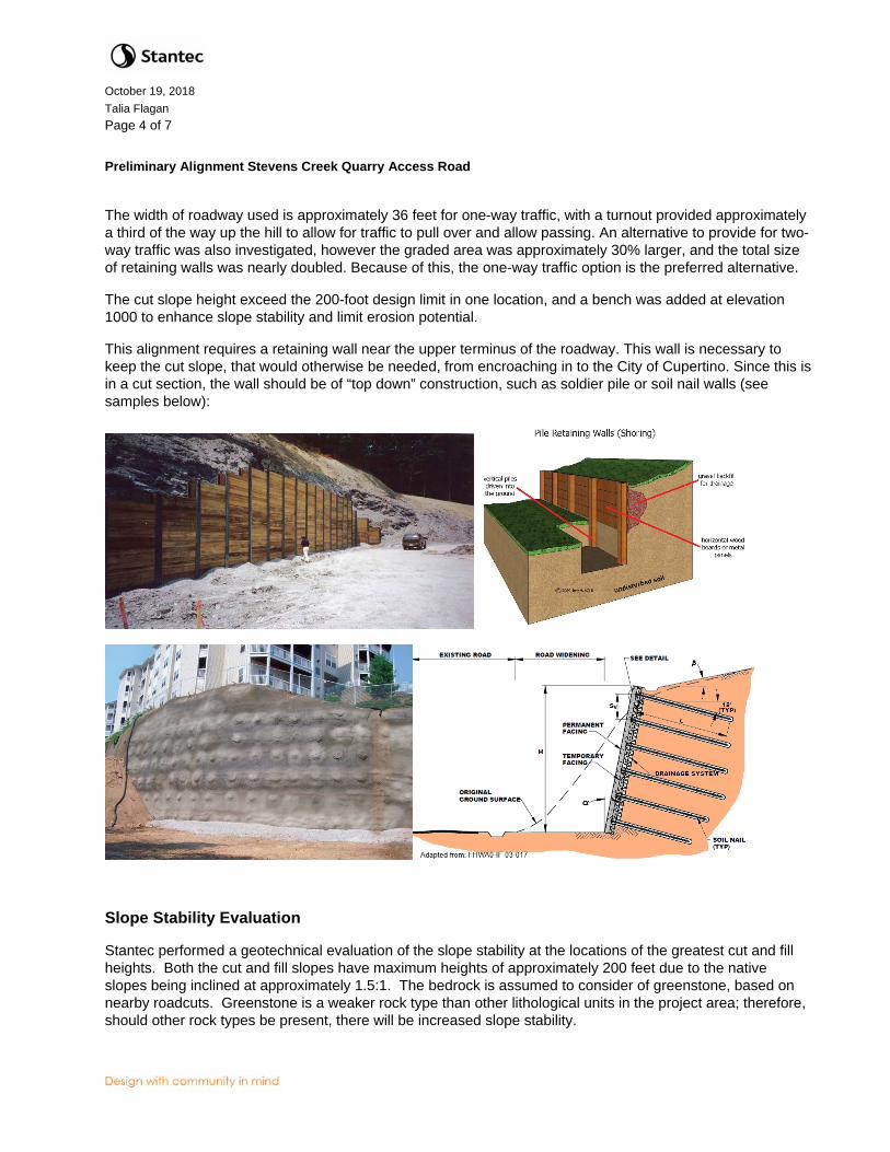
The width of roadway used is approximately 36 feet for one-way traffic, with a turnout provided approximately a third of the way up the hill to allow for traffic to pull over and allow passing. An alternative to provide for two-way traffic was also investigated, however the graded area was approximately 30% larger, and the total size of retaining walls was nearly doubled. Because of this, the one-way traffic option is the preferred alternative.
The cut slope height exceed the 200-foot design limit in one location, and a bench was added at elevation 1000 to enhance slope stability and limit erosion potential.
This alignment requires a retaining wall near the upper terminus of the roadway. This wall is necessary to keep the cut slope, that would otherwise be needed, from encroaching in to the City of Cupertino. Since this is in a cut section, the wall should be of “top down” construction, such as soldier pile or soil nail walls (see samples below):
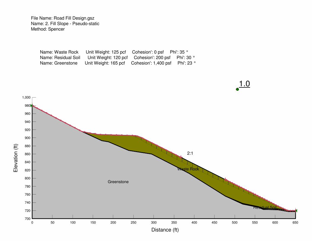
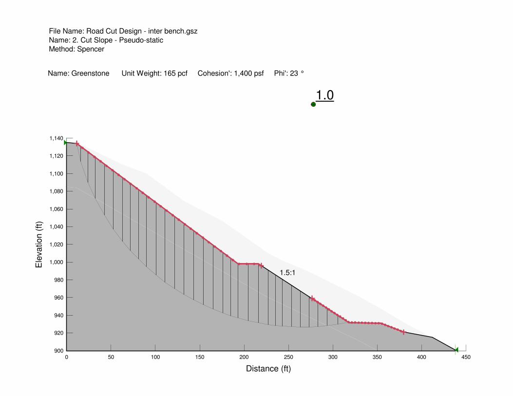
Slope Stability Evaluation
Stantec performed a geotechnical evaluation of the slope stability at the locations of the greatest cut and fill heights. Both the cut and fill slopes have maximum heights of approximately 200 feet due to the native slopes being inclined at approximately 1.5:1. The bedrock is assumed to consider of greenstone, based on nearby roadcuts. Greenstone is a weaker rock type than other lithological units in the project area; therefore, should other rock types be present, there will be increased slope stability.
October 19, 2018 Talia Flagan Page 5 of 7
Preliminary Alignment Stevens Creek Quarry Access Road
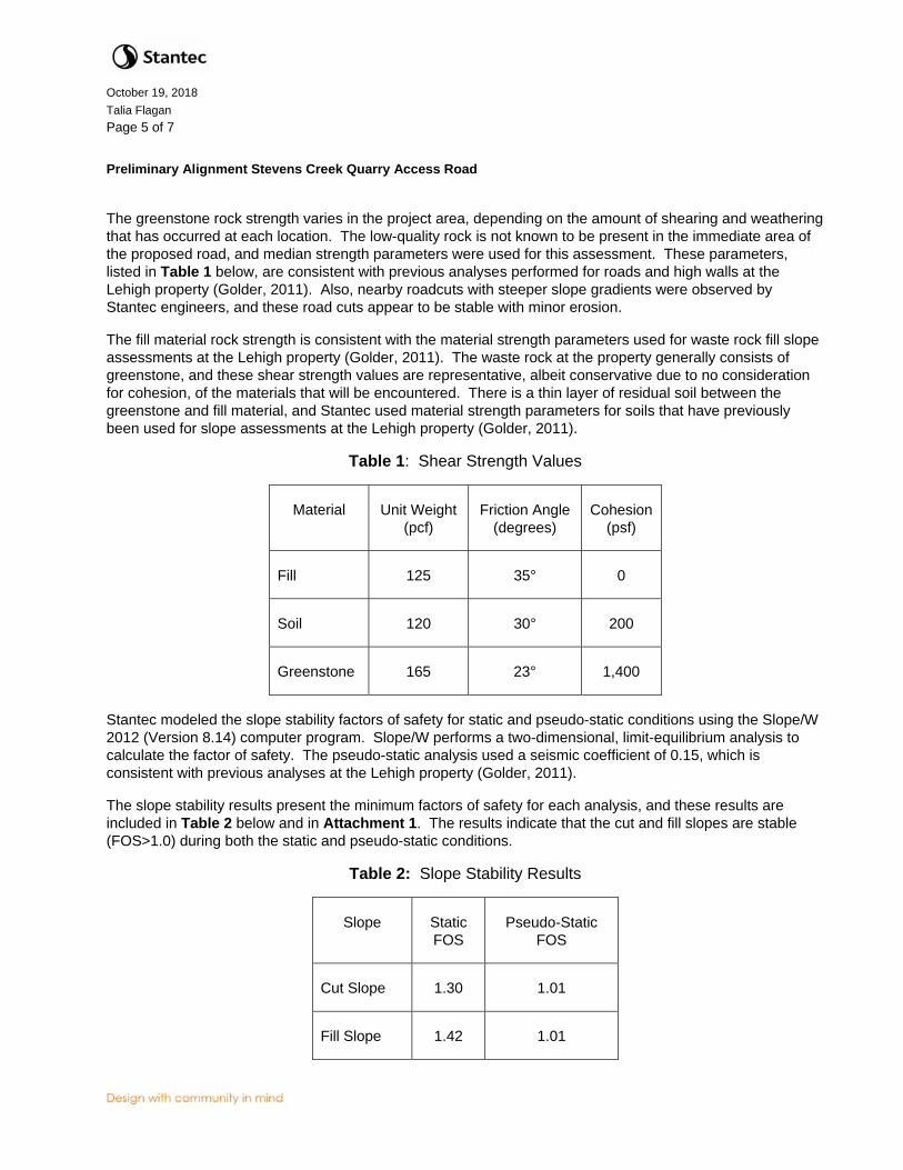
The greenstone rock strength varies in the project area, depending on the amount of shearing and weathering that has occurred at each location. The low-quality rock is not known to be present in the immediate area of the proposed road, and median strength parameters were used for this assessment. These parameters, listed in Table 1 below, are consistent with previous analyses performed for roads and high walls at the Lehigh property (Golder, 2011). Also, nearby roadcuts with steeper slope gradients were observed by Stantec engineers, and these road cuts appear to be stable with minor erosion.
The fill material rock strength is consistent with the material strength parameters used for waste rock fill slope assessments at the Lehigh property (Golder, 2011). The waste rock at the property generally consists of greenstone, and these shear strength values are representative, albeit conservative due to no consideration for cohesion, of the materials that will be encountered. There is a thin layer of residual soil between the greenstone and fill material, and Stantec used material strength parameters for soils that have previously been used for slope assessments at the Lehigh property (Golder, 2011).
Table 1: Shear Strength Values
Material Unit Weight (pcf)
Friction Angle (degrees)
Cohesion (psf)
Fill 125 35° 0
Soil 120 30° 200
Greenstone 165 23° 1,400
Stantec modeled the slope stability factors of safety for static and pseudo-static conditions using the Slope/W 2012 (Version 8.14) computer program. Slope/W performs a two-dimensional, limit-equilibrium analysis to calculate the factor of safety. The pseudo-static analysis used a seismic coefficient of 0.15, which is consistent with previous analyses at the Lehigh property (Golder, 2011).
The slope stability results present the minimum factors of safety for each analysis, and these results are included in Table 2 below and in Attachment 1. The results indicate that the cut and fill slopes are stable (FOS>1.0) during both the static and pseudo-static conditions.
Table 2: Slope Stability Results
Slope Static FOS
Pseudo-Static FOS
Cut Slope 1.30 1.01
Fill Slope 1.42 1.01

October 19, 2018 Talia Flagan Page 6 of 7
Preliminary Alignment Stevens Creek Quarry Access Road
Recommendations for Further Investigations
As mentioned above, a geologic and geotechnical investigation should be performed to verify the use of 1.5:1 cut slopes. This study should also determine if there are any areas along the alignment that could potentially be allowed to go even steeper, such as areas with solid rock and favorable bedding planes. Similarly, this study should confirm the greenstone rock quality and joint sets meet or exceed those assumed for this evaluation. The presence of shear zones or weathering may reduce rock strengths and require shallower slope gradients.
Potential Methods to Reduce Disturbance Area
This road design requires a large amount of disturbance to construct the road from the Permanente Aggregate plant to the Stevens Creek Quarry due to the steep gradients of the native slopes. This section discusses potential methods to reduce these disturbances. As discussed with each method, additional studies and analysis is required to confirm that these methods are feasibletting.
Increasing the cut and fill slope gradients is the simplest method to reducing the disturbance area. Evaluation of existing roads on site suggest that steeper slopes can be constructed. The cut slopes of 1.5:1 could potentially be increased depending on the rock type, strength, and quality. Pit wall designs for the quarry areas have established that 62° slopes are generally stable in limestone material on a bench to bench level with overall slopes of 45o, and 37° slopes are generally stable in greenstone material. However, weathered rock and shear zones may reduce these slopes significantly. During the initial road cutting, the rock should be evaluated for structure, rock type, and rock strength.
The road is an internal road with little potential for offsite impacts; therefore, it could be constructed to lower design standards than an offsite road. This would allow the cut and fill slopes to be steepened, regardless of the material, thus reducing the disturbance area. A key consideration with this method is that there will likely be increased maintenance requirements. As mentioned above, existing site roads typically have steeper cut and fill slopes that have performed adequately for numerous years. The geologic and geotechnical evaluation is still recommended for this option to minimize the potential for erosion on the slopes. It is also recommended that vegetation be established, and runoff controls be implemented to minimize erosion.
Additional civil structures could be incorporated to reduce the graded area, such as retaining walls similar to the one mentioned above in cut sections. In fill sections, reinforced earth type walls, such as welded wire mesh walls (see samples below) could be introduced to reduce the footprint of fill slopes. There would be a trade off to cost versus graded area in determining if additional walls are justified.
The attached exhibit utilized a constant cross section road width of 36 feet (24-foot clear width and 6-foot allowance for safety berms on each side). The width for safety berms can be eliminated for the portions of the roadway in cut. This may slightly reduce the graded area, but the impact is expected to be minor.
The current design assumes that all the drainage from the roadway will remain within the road section (no overside drains). With the steep grade of the roadway, this may create a maintenance issue with erosion of road surface. Future studies should assess the amount and velocity of flow and make recommendations as to the need for measures to control erosion.

October 19, 2018 Talia Flagan Page 7 of 7
Preliminary Alignment Stevens Creek Quarry Access Road
Closure
This report has been prepared for Lehigh Hanson to provide them with a conceptual road to transport aggregate material from the Permanente Aggregate plant to the neighboring Stevens Creek Quarry. Future studies are expected to verify the assumed conditions, and this should be confirmed prior to the commencement of any construction activities. As mutual protection to Lehigh, the public, and Stantec, this memorandum and its figures are submitted for exclusive use by Lehigh Hanson. We specifically disclaim any responsibility for losses or damages incurred through the use of our work for a purpose other than as described in this memorandum. Our memorandum and recommendations should not be reproduced, except in whole, without our express written permission.
Stantec Consulting Services Inc.
Paul S. Carey, P.E. Paul J. Kos, P.E. Senior Project Manager Senior Geological Engineer Phone: (909) 255-8214 Phone: (720) 889-6122 [email protected] [email protected]
Attachment: Stevens Creek Quarry Access Road Alignment and Grading Study Slope Stability Assessment

CUPERTINO CITY LIMITS
830
8
6
0
8
6
0
8
6
0
8
9
0
8
9
0
8
9
0
9
5
0
9
5
0
9
7
0
9
7
0
9
8
0
9
8
0
9
8
0
820
8
5
0
8
5
0
8
5
0
8
7
0
8
7
0
8
7
0
8
7
0
8
8
0
8
8
0
8
8
0
9
0
0
9
0
0
9
0
0
9
2
0
9
2
0
9
4
0
9
4
0
9
6
0
9
6
0
1
0
6
0
1
0
0
0
1030
1
0
3
0
1
0
3
0
1
0
4
0
1
0
4
0
1
0
4
0
990
9
9
0
9
9
0
9
3
0
9
3
0
9
1
0
9
1
0
810
8
4
0
8
4
0
810
8
3
0
8
3
0
820
8
0
0
7
9
0
7
8
0
7
7
0
7
6
0
7
5
0
2:1 F
ILL
T
U
R
N
O
U
T
1
.
5
:
1
C
U
T
2
:1
F
IL
L
2
:
1
F
I
L
L
BDY
BDY
BDY
BDY
BDY
BDY
BDY
BDY
BDY
BD
Y
BD
Y
BD
Y
BD
Y
BD
Y
BD
Y
CUPERTINO CITY LIMITS
800
1
0
5
0
1
0
5
0
1
0
2
0
1
0
2
0
1
0
2
0
1
.
5
:
1
C
U
T
1
0
1
0
1
0
1
0
1
0
1
0
1
0
1
0
1
.
5
:
1
C
U
T
B
E
N
C
H
1000
1000
1
0
0
0
DW
G:
Plo
tte
d:
O
ct 1
1, 2
01
8 - 1
0:5
0a
m
ta
lm
gre
n
By:
V:\2
04
2\a
ctive
\2
33
00
12
89
_P
erm
an
en
te
_Q
ua
rry\d
ra
win
g\E
xh
ib
it_
File
s\0
12
89
_P
erm
an
en
te
_Q
ua
rryC
-E
X7
00
2.d
wg
Know what's below.before you dig.Call
R
735 East Carnegie Drive Suite 280San Bernardino CA 92408-3588 909.335-6116 stantec.com
1 1
STEVENS CREEK QUARRY
ACCESS ROAD ALIGNMENT AND
GRADING STUDY

Technical Memo
Attachment 1 Slope Stability Assessment

Greenstone
Waste Rock
Residual Soil
1.4
Name: Waste Rock Unit Weight: 125 pcf Cohesion': 0 psf Phi': 35 °
Name: Residual Soil Unit Weight: 120 pcf Cohesion': 200 psf Phi': 30 °
Name: Greenstone Unit Weight: 165 pcf Cohesion': 1,400 psf Phi': 23 °
File Name: Road Fill Design.gsz
Name: 1. Fill Slope
Method: Spencer
2:1
Distance (ft)
0 50 100 150 200 250 300 350 400 450 500 550 600 650
Ele
vation (
ft)
700
720
740
760
780
800
820
840
860
880
900
920
940
960
980
1,000
Greenstone
Waste Rock
Residual Soil
1.0
Name: Waste Rock Unit Weight: 125 pcf Cohesion': 0 psf Phi': 35 °
Name: Residual Soil Unit Weight: 120 pcf Cohesion': 200 psf Phi': 30 °
Name: Greenstone Unit Weight: 165 pcf Cohesion': 1,400 psf Phi': 23 °
File Name: Road Fill Design.gsz
Name: 2. Fill Slope - Pseudo-static
Method: Spencer
2:1
Distance (ft)
0 50 100 150 200 250 300 350 400 450 500 550 600 650
Ele
vation (
ft)
700
720
740
760
780
800
820
840
860
880
900
920
940
960
980
1,000

1.3
Name: Greenstone Unit Weight: 165 pcf Cohesion': 1,400 psf Phi': 23 °
File Name: Road Cut Design - inter bench.gsz
Name: 1. Cut Slope
Method: Spencer
1.5:1
Distance (ft)
0 50 100 150 200 250 300 350 400 450
Ele
vation (
ft)
900
920
940
960
980
1,000
1,020
1,040
1,060
1,080
1,100
1,120
1,140
1.0
Name: Greenstone Unit Weight: 165 pcf Cohesion': 1,400 psf Phi': 23 °
File Name: Road Cut Design - inter bench.gsz
Name: 2. Cut Slope - Pseudo-static
Method: Spencer
1.5:1
Distance (ft)
0 50 100 150 200 250 300 350 400 450
Ele
vation (
ft)
900
920
940
960
980
1,000
1,020
1,040
1,060
1,080
1,100
1,120
1,140