perception, history, and science: coherence or disparity ... · timing of the little ice age...
TRANSCRIPT

Polar Record 41 (219) 319ndash334 (2005) Printed in the United Kingdom doi101017S0032247405004687 319
Perception history and science coherence or disparity in thetiming of the Little Ice Age maximum in southeast IcelandKrista M McKinzeyInstitute of Geography School of GeoSciences University of EdinburghDrummond Street Edinburgh EH8 9XP (KristaMcKinzeyedacuk)
Rannveig OlafsdottirUniversity of Iceland HornafjorDur University Centre NyheimarLitlubru 2 780 Hofn Iceland (rannyhiis)Andrew J DugmoreInstitute of Geography School of GeoSciences University of EdinburghDrummond Street Edinburgh EH8 9XP (ajdgeoedacuk)Received March 2005
ABSTRACT In Iceland studies that integrate local perceptions about the landscape with scientific evidence ofchange have been few This article presents a case study from southeast Iceland that has two main objectives Firstlyethnographic data is used to explore the human dimension of the Little Ice Age through perceptions of landscape andclimatic change and to describe the impacts that these changes had on life and livelihood Secondly the paper criticallyassesses the coherence of the scientific record regarding the Little Ice Age glacial maximum with evidence gained fromthe ethnographic survey and the local historical record Although climatic deterioration from the seventeenth throughnineteenth centuries ultimately affected farming viability it was the interplay of climate with concomitant culturaland socio-economic factors that ensured effective strategies were emplaced to preserve life and livelihood in southeastIceland Furthermore despite different trajectories of perception emanating from either the scientific or the local pointsof view data from all sources are strongly coherent and point to a Little Ice Age maximum during the late eighteenthto early nineteenth centuries This study also illustrates that sensitive landscapes can lsquostore memoriesrsquo through thecumulative accumulation of disturbances during periods of climatic variability eventually reaching a critical thresholdand inducing landscape instability such as occurred during the nineteenth century
Contents
Introduction 319Methods 322Evidence for the LIA glacial maximum 322Synthesis of environmental indicators 325Life in the seventeenth through nineteenth
centuries 329The LIA maximum in southeast Iceland
coherence or disparity 332Conclusions 332Acknowledgements 333References 333
Introduction
The lsquoLittle Ice Agersquo (LIA) is a widely used termfor the period c AD 1300ndash1900 which was notablefor worldwide glacier expansion (Grove 2004) Acrosshistorical archaeological and environmental sciencesthe LIA term has been used with differing emphasis anddifferent connotations A fundamental reason is that theLIA was not a time of uniform cold at either the regional orthe hemispheric scale (see Jones and Mann 2004) Ratherthe period encompassed considerable climatic variabilityand as a consequence glacier termini fluctuated aroundadvanced positions for several centuries although thetiming and magnitude of expansion were not necessarilysynchronous worldwide (for example Gellatly and others
1988 Karlen 1988 McKinzey and others 2004a) Thevariability of climate during the LIA commonly featuresin studies of historical climatology (Ladurie 1971 Lamb1977) and lsquovariabilityrsquo rather than simply lsquocoldrsquo maybe seen as a key characteristic In addition the temporaland spatial variations in climate combined with differentenvironmental response rates and sensitivities to climatechange indicate that the LIA record is complex (Bradwell2001a Kirkbride and Dugmore 2001 McKinzey andothers 2004b)
When attempting to gauge the potential cultural socio-economic impact of LIA climate change on human beingsa number of issues are brought to light Firstly theissue of significance which may be linked to problemsof circularity historical records of certain events (suchas harvest times) may be used to reconstruct details ofLIA climate although these proxy records could alsobe used to argue for a climatic role in the developmentof such events mdash for example the harvest timingwhich may actually be determined by other non-climaticfactors Secondly the issue of quality illustrated by statusgiven to either an environmental proxy record of pastchanges or human experience of the past In this contexttravellersrsquo tales or farmersrsquo diaries noting past glacialpositions may be argued to be lsquosuperiorrsquo or lsquoinferiorrsquoto records derived from other methodologies such aslichenometrically dated geomorphology People socio-economic systems and facets of the natural environment
httpswwwcambridgeorgcoreterms httpsdoiorg101017S0032247405004687Downloaded from httpswwwcambridgeorgcore Columbia University - Law Library on 01 Mar 2017 at 025747 subject to the Cambridge Core terms of use available at
320 MCKINZEY OLAFSDOTTIR AND DUGMORE
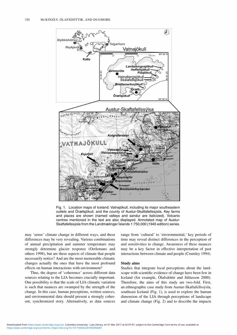
Fig 1 Location maps of Iceland Vatnajokull including its major southeasternoutlets and Oraeligfajokull and the county of Austur-Skaftafellssysla Key farmsand places are shown (named valleys and sandur are italicized) Volcaniccentres mentioned in the text are also displayed Annotated map of Austur-Skaftafellssysla from the Landmaeliglinger Islands 1750000 (1945 edition) series
may lsquosensersquo climate change in different ways and thesedifferences may be very revealing Various combinationsof annual precipitation and summer temperature maystrongly determine glacier response (Oerlemans andothers 1998) but are these aspects of climate that peoplenecessarily notice And are the most memorable climaticchanges actually the ones that have the most profoundeffects on human interactions with environment
Thus the degree of lsquocoherencersquo across different datasources relating to the LIA becomes crucially importantOne possibility is that the scale of LIA climatic variationis such that nuances are swamped by the strength of thechange In this case human perceptions written sourcesand environmental data should present a strongly coher-ent synchronized story Alternatively as data sources
range from lsquoculturalrsquo to lsquoenvironmentalrsquo key periods oftime may reveal distinct differences in the perception ofand sensitivities to change Awareness of these nuancesmay be a key factor in effective interpretation of pastinteractions between climate and people (Crumley 1994)
Study aimsStudies that integrate local perceptions about the land-scape with scientific evidence of change have been few inIceland (for example Olafsdottir and Julıusson 2000)Therefore the aims of this study are two-fold Firstan ethnographic case study from Austur-Skaftafellssyslasoutheast Iceland (Fig 1) is used to explore the humandimension of the LIA through perceptions of landscapeand climate change (Fig 2) and to describe the impacts
httpswwwcambridgeorgcoreterms httpsdoiorg101017S0032247405004687Downloaded from httpswwwcambridgeorgcore Columbia University - Law Library on 01 Mar 2017 at 025747 subject to the Cambridge Core terms of use available at
PERCEPTION HISTORY AND SCIENCE THE LITTLE ICE AGE MAXIMUM IN ICELAND 321
Fig 2 A conceptual model that illustrates how perceived climatic and landscapechanges result from two different trajectories of perception The farmerrsquos percep-tions are formed through personal experiences that may become incorporatedinto the historical record and from which the sea-ice record has been extractedCollectively this information provides a meaningful interpretation of past climatethat has been passed down through written and oral transmissions In contrastthe scientific method utilizes the physical environment including sea-ice recordsas indicators of change This study presents an holistic approach that integratesall sources of information relevant to the impact and magnitude of LIA changes insoutheast Iceland in order to assess whether these different perception trajectoriesdo in fact corroborate one another
that these changes had on life and livelihood Second thispaper critically assesses the coherence of environmentalrecords of glacier expansion instrumental records oftemperature and precipitation proxy records of sea-iceextent based on written sources reconstructions of con-temporaneous synoptic conditions the historical recordand results from the ethnographic survey Additionallyenvironmental changes not directly related to climatesuch as volcanic eruptions which may have impactedpersonal welfare in the region are also discussed Thissecond objective not only permits an analysis of theintegration of the scientific record with mostly qualitativeindications of change but also examines the way inwhich different trajectories of perception may convergeon similar conclusions regarding both the LIA climate andenvironment (Fig 2)
Study areaDue to its position astride the atmospheric Arctic Front(the convergence zone between temperate maritime andcold polar air masses) and the oceanic Polar Front (theboundary between warm waters of the Atlantic and coldArctic waters Bjornsson 1979 Ogilvie 1992) Icelandis well placed to experience climatic shifts of the scale
typical of the late Holocene These climate changesare registered in the fluctuations of Icelandic glaciersAccurate age-dating of glaciogenic deposits associatedwith the former extent of ice margins provides a means ofestablishing the timing of maximum terminus positionsand allows inferences about the prevailing climate to bemade
Vatnajokull the largest European ice cap(sim8100 km2) is located in southeast Iceland (Fig 1)and has been the focus of much geomorphologicallybased research into the timing and magnitude of LIAglacier fluctuations (for example GuDmundsson 1997Evans and others 1999 Bradwell 2001b 2004 Kirkbrideand Dugmore 2001 McKinzey and others 2004b inpress) Although these studies have narrowed the windowregarding the timing of the LIA glacier maximumin southeast Iceland to the late eighteenth to earlynineteenth centuries little emphasis has been placedon local knowledge of the environment and humanperception of LIA climatic changes since Rorarinssonrsquospioneering study in 1943 Austur-Skaftafellssysla whichuntil recent decades was one of the more isolatedlocations in the country due to fluctuations of the largeVatnajokull outlet glaciers jokulhlaups and frequent
httpswwwcambridgeorgcoreterms httpsdoiorg101017S0032247405004687Downloaded from httpswwwcambridgeorgcore Columbia University - Law Library on 01 Mar 2017 at 025747 subject to the Cambridge Core terms of use available at
322 MCKINZEY OLAFSDOTTIR AND DUGMORE
Table 1 Major environmental indications obtained from questionnaires interviews and literature study
AD 1600ndash1700 environment lsquostablersquoBreiDamerkursandur inhabitedRivers navigableGlaciers begin to expand and slowly advance
AD 1700ndash1750 environment lsquomoderately stablersquoRivers remain relatively navigableGlaciers continue to grow larger and advance quickens
AD 1750ndash1800 environment lsquounstablersquoBreiDamerkursandur abandoned in AD 1750Jokulhlaups noted for the first time as a hazard (details regarding where they emanated from are lacking)Widespread and major glacier advance during later part of period (sim1780sndash1790s) some reach LIA maximumBreiDamerkurjokull is 75 km from the coastline in AD 1756 although by AD 1794 it is 1880 m from the coastline
AD 1800ndash1850 environment lsquounstablersquoGlacier retreat and obvious glacier moraines are noted for the first timeMilder climateViDidalur inhabited AD 1835ndash38 and AD 1847ndash49
AD 1850ndash1900 environment lsquoextremely unstablersquoWidespread glacier fluctuations with major advance during second half of the period others reach their LIA
maximum or extend to nearly the same length as in the late eighteenth century
The farm Fell is destroyed by flooding and subsequently buried by BreiDamerkurjokull in AD 1869In AD 1874 BreiDamerkurjokull is 228 m from the coastlineIce-dammed lakes Dalvatn and Vatnsdalur form and frequent jokulhlaups In AD 1894 Heinabergsjokull extends
onto the sandur but still significant land between the glacier terminus and the older (eighteenth-century)moraines
Flaajokull almost crosses Kolgrafardalur The farm Haukafell is moved because of steady advance during the lastdecade of the twentieth century
volcanic activity has long experienced an intimaterelationship between its occupants and the marginalland on which humans have depended for their survival(Rorarinsson 1956)
Methods
During autumn 2003 a questionnaire was distributedto 100 farmers in the county of Austur-Skaftafellssysla(Fig 1) This sample represented 50 of all farmers in thecounty selected as every second name on the register listThe questionnaire was made up of open-ended questionsaimed to focus on the recipientsrsquo own comments andperceptions It consisted of three sections of which thefirst asked seven questions regarding interpretation ofclimate-change indicators (for example lsquowhat makes aldquobad seasonrdquo badrsquo) the second asked four questionsregarding interpretation of historical (environmental)events (for example the timing of the maximum historicaladvance of Vatnajokull glaciers) and the third had oneentry (lsquoother informationrsquo) Twenty-five of the question-naires were returned All respondents were subsequentlyinterviewed during summer 2004 The interview involveda more detailed discussion about individual interpretationand memories of historical environmental changes insoutheast Iceland Each interview was conducted inIcelandic and responses were later translated into EnglishThe interview was structured around five questionsalthough any description concerning the glaciers mdash suchas extent distribution outlook or difficulties of crossingor climbing mdash was also noted Information collected fromeach technique was then assessed for reliability through
comparison with each relevant questionnaire or interviewas well as across all questionnaires and interviews
Subsequently an investigation into local Icelandicliterature was undertaken to compare the farmersrsquo know-ledge and perceptions to an independent study of historicaldocuments and data The literature studied included travelbooks biographies parish records and local researchesAll of the data (questionnaire interview and literature)were classified into time periods from AD 1600 to1900 in order to recognize any lsquosynchroneityrsquo in thediverse range of qualitative sources as well as to collateimplications regarding climate environmental changesand fluctuations of the glaciers during the most criticalLIA period (Table 1) Overall this plethora of informationwas then compared to the scientific record available forthe same time period
Evidence for the LIA glacial maximum
Human perception of climate-change indicatorsAs expected the farmersrsquo interpretation of climate-changeindicators suggests a deep understanding that climateultimately determined survival in Austur-SkaftafellssyslaHence lsquobad seasonsrsquo included any factor that reducedtheir personal well-being and economic wealth partic-ularly with regard to haymaking and livestock suchas prolonged winters chilly springs with severe frostsand rainy or cool summers Critically they perceivedlsquochangeable weatherrsquo (variability) during all seasons tobe responsible for lsquobad seasonsrsquo and lsquobad yearsrsquo
Farmers noted changes to the landscape after periodsof lsquobad weatherrsquo These changes included frost damageto grass swards that had a direct impact on the quantity
httpswwwcambridgeorgcoreterms httpsdoiorg101017S0032247405004687Downloaded from httpswwwcambridgeorgcore Columbia University - Law Library on 01 Mar 2017 at 025747 subject to the Cambridge Core terms of use available at
PERCEPTION HISTORY AND SCIENCE THE LITTLE ICE AGE MAXIMUM IN ICELAND 323
and quality of haymaking and changes in the glacialrivers directly associated with fluctuations of the glaciersAlthough not a direct result of lsquobad weatherrsquo climaticconditions that were responsible for jokulhlaups (glacieroutburst floods) became a significant hazard to life andlivelihood in Austur-Skaftafellssysla in terms of propertydestruction caused by the flood itself and river channelmovements In particular changes across the countylowlands after a jokulhlaup from BreiDamerkurjokullHeinabergsjokull and Skalafellsjokull (Fig 1) wereremembered Sandar (glacier outwash plains singularlsquosandurrsquo) in the county are riddled with palaeochannelsglaciofluvial terraces and old lake shorelines that area reminder to the farmers of the destructive power ofjokulhlaups
lsquoBad yearsrsquo of prolonged extreme weather impactedfarmers mostly in terms of changing wealth and mortalitySuccessive years of lsquobad [cold]rsquo winters and springswere deadly for young livestock and wet summers orcool autumns decreased the fodder yield thus threateningsocial status and the regional economy Furthermore lsquobadyearsrsquo were also characterized as successive short coldsummers and long cold stormy winters One respondentmentioned that this part of Iceland (due to its extremeenvironment) was traditionally poor during the historicalperiod lsquoPeople were poor had little clothing hypothermiaand pneumonia were common rsquo hence populationmortality was also perceived to increase during lsquobadyearsrsquo
The farmers believe that they have lsquogood knowledgersquoof the landscape primarily because of their constantinteraction with the environment (for example annualsheep gathering) Images of landscape are remembered byfarmers as a mixture of mental lsquomapsrsquo and oral descrip-tions of the land and travel routes throughout the county
Ethnographic survey and local written sourcesAD 1600ndash1900
AD 1600ndash1700The respondentsrsquo knowledge of this period mostly comesfrom oral transmittance and historical travel books writtenabout BreiDamerkursandur (Fig 1 Eythornorsson 1952Rorarinsson 1956 Bjornsson 1998) During the seven-teenth century farms and vegetation were widespreadon sandar and glacial rivers could usually be crossedTherefore the environment seems to have mainly beenlsquostablersquo However noticeable glacier advances begansimAD 1650 and ice began to block previously usedmountain roads and traditional grazing routes that hadbeen in existence since before AD 1600
Overall most of the historical accounts describe thelandscape around BreiDamerkurjokull (Fig 1) probablybecause of its role as a barrier to the only route betweenwest and east (Eythornorsson 1952) Travelers into Austur-Skaftafellssysla either had to cross the glacial riverJokulsa or hike across the glacier itself Either optionwas daunting as Jokulsa was reputed to be one ofthe most difficult and dangerous rivers to cross in thecountry although during periods of glacier advance
glacial rivers are usually smaller or of less volumethan during periods of retreat when substantial flowsof meltwater occur Traversing BreiDamerkurjokull tookseveral hours due to the development of crevasses acommon characteristic of glacial advance Therefore themore advanced BreiDamerkurjokull became the moredifficult it became to cross and farmersrsquo trade that tookplace in the villages of Papos or Djupivogur on the eastcoast was hindered By AD 1695 and 1698 the farms Fjalland BreiDa established shortly after the Viking settlement(AD 874) on the western part of BreiDamerkursandurwere abandoned along with their grazing lands due toencroaching ice (Rorarinsson 1956 Bjornsson 1998)Fjall was located at the southeast foot of the mountainBreiDamerkurfjall and BreiDa somewhat farther eastBreiDamerkurfjall is recorded to have been surroundedby ice around AD 1700 (for example Bjornsson 1998)
AD 1700ndash1750According to the survey and literature investigationsthe environment seems to have been lsquomoderately stablersquoduring the first half of the eighteenth century Most farmsremained intact and according to the first populationcensus taken in Iceland in AD 1703 the remaining farmsin BreiDamerkursandur contained 39 residents (StatisticalBureau of Iceland 1960) However it appears that glacieradvance as indicated by BreiDamerkurjokull quickenedduring this period For example BreiDamerkurjokullwas seen for the first time in simAD 1730 from thefarm Reynivellir (Fig 1 RorDarson 1993) and a countydescription of the area dating to AD 1744ndash49 describedBreiDamerkurjokull as lsquolarge and horriblersquo (Syslulysingar1744ndash49) The registry clerk also noted that the glacialrivers were not so dangerous or difficult to cross aslater became dominant in the area descriptions Fur-thermore prominent or notable moraines did not existon BreiDamerkursandur during this time and indicationswere given of moraines being absent from elsewhere onthe sandar in Austur-Skaftafellssysla Overall it does notseem as though the glaciers had much social or economicimpact on the residents of southeast Iceland during the firsthalf of the eighteenth century apart from the difficultiesof glacier crossings and the knock-on effects in trade withthe smaller communities farther east
AD 1750ndash1800Overall a transition to environmental lsquoinstabilityrsquo may beinferred during this period Firstly the respondents con-sidered that glaciers in the region were at their lsquogreatestrsquoduring the second half of the eighteenth century Thisinterval included a visit of the Icelandic pioneers in naturalsciences Eggert Olafsson and Bjarni Palsson to Austur-Skaftafellssysla in AD 1756 (Olafsson and Palsson1981) who described the edge of BreiDamerkurjokull asvery steep but crevasse-free Such conditions indicatecontinuing advance from earlier in the centuryBreiDamerkursandur had already been abandoned by AD1750 which implies reduced viability of the previouslyprosperous farms Olafsson and Palsson also confirmedthe lack of notable or prominent moraines around the
httpswwwcambridgeorgcoreterms httpsdoiorg101017S0032247405004687Downloaded from httpswwwcambridgeorgcore Columbia University - Law Library on 01 Mar 2017 at 025747 subject to the Cambridge Core terms of use available at
324 MCKINZEY OLAFSDOTTIR AND DUGMORE
edge of the glacier Additionally they mentioned a glaciercalled Kalfafellsjokull (this name no longer exists) whichterminated close to the church farm KalfafellsstaDur inKalfafellsdalur (Fig 1) They may have been referring tothe present-day small ice tongue Brokarjokull which cur-rently hangs over a spur sim15 km distant at the valley heador Sultartungnajokull (also called Eyvindstungnajokull)a small lobe that diverges from the south margin ofSkalafellsjokull Olafsson and Palsson further noted thatHeinabergsjokull (then coalesced with Skalafellsjokull)terminated adjacent to the farm Heinaberg in AD 1756(Fig 1)
During the summers of AD 1793 and 1794 thegeologist Sveinn Palsson travelled throughout Austur-Skaftafellssysla (Palsson 1983) During his first visit heobserved that part of BreiDamerkursandur was vegetatedand that these fields were used for grazing by the farmersin the districts of HornafjorDur and Oraeligfi He also notedthat most of the rivers were lsquocalm and smallrsquo However hementioned that this situation had changed dramatically ayear later during the summer of AD 1794 and his writingsimply significant climatic variability For example hedescribed lsquoturbulencersquo (crevasses) in many glaciers thussuggesting rapid advance especially at Kvıarjokull nearthe farm Kvısker and at BreiDamerkurjokull (Fig 1)More specifically BreiDamerkurjokull probably advanced57 km between Olafsson and Palssonrsquos reference inAD 1756 (terminus 75 km from the coastline) andPalssonrsquos description in AD 1794 (terminus 1880 mfrom the coastline) However distances measured usingthe coastline as a reference must be interpreted withcaution because it is formed from lsquosoft sedimentrsquopotentially subject to either aggradation (from glacialoutwash) or erosion (from coastal process) Howeverdespite this caveat BreiDamerkurjokull clearly advanced aconsiderable distance between the mid and late eighteenthcentury Brennholar a tenant farm of Fell was alsoabandoned in AD 1794 due to advancing ice (Bjornsson1998 Fig 1) Additionally Palsson noted that localresidents complained about increasingly cold and foggyconditions in the time that BreiDamerkurjokull underwentrapid advance towards the end of the century
The second half of the eighteenth century also yieldsthe first mention of jokulhlaups in Austur-Skaftafellssyslaby the respondents Additionally some referred to thelsquogreat sea-ice yearsrsquo at the end of the eighteenth centurywhen for example it was possible to walk on ice to theoffshore island Papey A story has also been passed downfrom the respondents that tells of a man who killed a polarbear with a home-made gun during this period
AD 1800ndash1850It appears that the environment continued to be lsquounstablersquoand variable during the early nineteenth century Overallrespondents referred to a period of milder weather thatthey said allowed previously uninhabitable locations mdashsuch as VıDidalur an isolated valley near Vatnajokull(Fig 1) mdash to be occupied and farmed during AD 1835ndash38
and again in 1847ndash49 (Geirsson 1995) The literature alsoindicates that the glaciers generally retreated during thefirst half of the nineteenth century Ebenezer Hendersona traveller to Austur-Skaftafellssysla during AD 1814 and1815 (Henderson 1957) specifically referred to morainesobserved for the first time which indicates glacier retreatfrom the late eighteenth-century advance Hendersondescribed them as lsquolarge loads of clay sand and grassroots[that] have been mounded up and thus formed a chain ofsmall hills along the glacier edgersquo
AD 1850ndash1900Environmental lsquoinstabilityrsquo appears to have been at itspeak during the last half of the nineteenth century Glaciertermini in Austur-Skaftafellssysla apparently fluctuatedbetween AD 1850 and 1870 thus causing havoc forfarmers and their fields due to the constantly changingglaciers rivers and sandar For instance Nils OhlssonGadde who travelled across the area during summerAD 1857 described BreiDamerkursandur as lsquoa vast sanddesertrsquo and stated that the BreiDamerkurjokull terminuschanged position lsquoabout every fifth yearrsquo (Gadde 1983)
However another period of major advance seems tohave begun along the southeastern margin of VatnajokullsimAD 1870 to 1900 All respondents believed that withfew exceptions lsquothe glaciers reached the furthermostmorainesrsquo during this period thus referring to olderoutermost moraines deposited before the end of thenineteenth century BreiDamerkurjokull apparently wasone exception and it seems to have reached its greatestextent simAD 1870 The site of the farm Fell was destroyedby the glacier in AD 1869 as the glacial river brokethrough the older moraines and thus was moved higherupslope for safety The tenant farms were also destroyedand the grazing lands were then subsequently inundatedby ice (Bjornsson 1998) Additionally William LordWatts who visited Austur-Skaftafellssysla in AD 1874recorded that BreiDmerkurjokull was only 228 m from thecoastline and farmers were anxious that the glacier wouldfinally reach the coast and lsquocompletely cut off access fromwest to eastrsquo (Watts 1962)
Rorvaldur Thoroddsen an Icelandic naturalist who tra-versed Austur-Skaftafellssysla in AD 1894 (Thoroddsen1959) wrote that Flaajokull had reached the outermostglacier moraines by this time (Fig 1) This clearlyindicates that Flaajokull had been just as extensivesometime prior to the late nineteenth century and contra-dicts recent investigations using lichenometrically datedmoraines (for example Dabski 2002) Furthermore alocal farmer informed Thoroddsen that Flaajokull hadadvanced and retreated on three occasions between AD1882 and 1894 and had reached approximately the sameextent each time During this time the farm Haukafellwas moved farther west and to a higher elevation tolsquoescapersquo the advancing Flaajokull which nearly closed theentrance to Kolgrafardalur simAD 1900 (Benediktsson1977 Fig 1)
httpswwwcambridgeorgcoreterms httpsdoiorg101017S0032247405004687Downloaded from httpswwwcambridgeorgcore Columbia University - Law Library on 01 Mar 2017 at 025747 subject to the Cambridge Core terms of use available at
PERCEPTION HISTORY AND SCIENCE THE LITTLE ICE AGE MAXIMUM IN ICELAND 325
Thoroddsen (1959) also noted that in AD 1894Heinabergsjokull (still coalesced with Skalafellsjokull)extended onto the sandur although it was a considerabledistance from the outermost moraines which werelikely deposited around the abandoned farm Heinabergsometime during the late eighteenth century Rorarinsson(1943) also recorded accounts by local farmers thatHeinabergsjokull was close to these lsquooutwash morainesrsquoduring the 1860s and 1870s This implies that theglacier had advanced to similar but subsequently less-extended limits during the waning stages of the LIAand does not corroborate a late nineteenth-century LIAmaximum (Evans and others 1999) During the end ofthe nineteenth century Heinabergsjokull had also createdan ice-dammed lake Dalvatn in Heinabergsdalur andanother one in Vatnsdalur (Fig 1) the latter full of waterup to the col at 464 m asl As the glacier thinned andbegan to retreat during the late nineteenth and earlytwentieth centuries either or both of these lakes wouldburst as a jokulhlaup (sim1 per year in the late summeror early autumn) One respondent stated that lsquoMyrar [adistrict of Austur-Skaftafellssysla] was like an oceanrsquoThese floods lasted for a couple of days with a maximumrunoff sim3000 m3 sec1 and obviously caused much damageto the surrounding farms (Rorarinsson 1956) Floodsemanating from Vatnsdalur rather than those spawnedby a burst from Dalvatn were perceived as the mostdangerous
Overall the evidence for the last half of the nine-teenth century implies an extremely variable climateFor instance VıDidalur was resettled in AD 1883ndash97 when grazing was possible in the highland valleyalthough cold years such as in AD 1884 resulted insea ice that reached all the way to the village of Vıkon the south coast and persisted until late summer(Jonsson 1954) Glacier retreat was extensive by the turnof the twentieth century as one resident recalled thatfishermen off the coast of Kvısker told of seeing lsquoblackmountain topsrsquo (the nunataks of Esjufjol Fig 1) forthe first time protruding from BreiDamerkurjokull in AD1907
Synthesis of environmental indicators
Environmental data derived from proxy sources includ-ing glacier chronology instrumental climate records
Table 2 Summary of environmental-change indicators AD 1600ndash1900 Ranks (italicized) were provided equally foreach indicator (1 = lowestleast extreme to 5 = highestmost extreme) Numbers in brackets exclude ranks for thelandscape stability indicator to illustrate the extent to which local perceptions modify the scientific view of changedaggerDenotes the period with the coldest temperatures during the LIA (1780s) according to the sea-ice record DaggerDenotesthe period with the coldest temperatures after instrumental records began (1870s and 1880s)
Period NAO index Glacier extent Landscape(years AD) Volcanic frequency Sea-ice index (negative) or advance rate stability Totallowast
1600ndash1700 013 2 2 0606 5 2 1 12(11)1700ndash1750 024 5 1 0571 2 3 2 13(11)1750ndash1800 018 3 5 0592 4 5 3 20(17)dagger1800ndash1850 008 1 3 0531 1 1 4 10(6)1850ndash1900 020 4 4 0580 3 4 5 20(15)Dagger
sea-ice indices reconstructions of the North AtlanticOscillation (NAO) and volcanic frequency have beencollated to present a new synthesis of environmentaland climatic changes during the past few hundred years(Figs 3 4 5) Previous glacier chronologies basedon tephrochronologically constrained lichenometry (forexample Bradwell 2001a McKinzey and others 2004b)suggest a late eighteenth- or early nineteenth-century LIAglacier maximum in Austur-Skaftafellssysla Howeverthe instrumental climate record which began in AD1823 shows significant climatic variability during thewaning stages of the LIA in the late nineteenth centuryReconstructions of Icelandic sea-ice extent based onindices unequivocally sourced from documentary recordsand annals that span the last sim1000 years indicate astrong correlation between sea-ice incidence and landsurface temperature (Bergthornorsson 1969 Ogilvie 1984)Cold periods involving extreme sea-ice conditions seemto develop most readily during negative NAO years whenwesterly winds decrease due to a weakened pressuregradient across the North Atlantic Hence Iceland be-comes colder and more arid as the Polar Front moves south(Glueck and Stockton 2001 Bradwell 2001a) During theLIA residents of Austur-Skaftafellssysla also had to copewith frequently occurring volcanic eruptions that oftendeposited tephra (volcanic ash) across the area Tephramay act as an agent of environmental and cultural changeeither directly from fallout onto settlements (for examplethe Oraeligfajokull eruption in AD 1362 Rorarinsson 1956)or indirectly such as large-scale animal mortality andrelated famine caused by fluorosis (for example theKatla eruption in AD 1755 and Laki in AD 1783 Vasey1996)
To permit quantitative assessment of the most to leastextreme periods of environmental change between AD1600 and 1900 environmental indicators were rankedand divided by their relevant period (for example 50or 100 years Table 2) Ranks were provided equallyfor each indicator (that is 1 = lowestleast extreme to5 = highestmost extreme) so that all indicators main-tained equal importance For indicators that could not becalculated rank was based on qualitative interpretationThe following sections describe LIA environmentalchange in southeast Iceland based on the collectiveinformation gained from a consideration of all indicators
httpswwwcambridgeorgcoreterms httpsdoiorg101017S0032247405004687Downloaded from httpswwwcambridgeorgcore Columbia University - Law Library on 01 Mar 2017 at 025747 subject to the Cambridge Core terms of use available at
326 MCKINZEY OLAFSDOTTIR AND DUGMORE
Fig 3 Trends in Stykkisholmur and Teigarhorn mean annual temperature for AD1823ndash1999 and 1873ndash1999 respectively along with the cumulative departures fromthe means Note that the early 1920s was a critical lsquoturnaroundrsquo period that is the endof the lsquoLittle Ice Agersquo after which climate in southeast Iceland became significantlywarmer However significant and widespread glacier retreat had already begun by theend of the nineteenth century Data from the Icelandic Meteorological Office
used in this study separated into the same periods as thatof the previous section
AD 1600ndash1700Sea-ice incidence gradually increased towards the end ofthe seventeenth century (Ogilvie 1992) Additionally theNAO index was mostly negative during this period andreached its lowest value in the LIA simAD 1695 (Cookand others 2002) However positive indices also occurredaround the 1650s These proxies indicate cold and dryconditions for most of the century which when summerswere short and cool were conducive to glacier expan-
sion Dendrochronologically reconstructed mean AprilndashSeptember temperatures by Briffa and others (2002) alsogenerally show that the seventeenth century was coldacross northern Europe with the most negative anomalies(ndash1C below the AD 1961ndash90 mean) simAD 1640 1660ndash70 and sim1700 Ethnographic and historical evidencesupports the idea of a landscape that although beginningto change remained relatively lsquostablersquo throughout mostof the century and the main indication of LIA climaticdeterioration pertained to slow expansion and advance ofglaciers in Austur-Skaftafellssysla Eruption frequency ofthe Vatnajokull volcanic system was moderate (Larsen
httpswwwcambridgeorgcoreterms httpsdoiorg101017S0032247405004687Downloaded from httpswwwcambridgeorgcore Columbia University - Law Library on 01 Mar 2017 at 025747 subject to the Cambridge Core terms of use available at
PERCEPTION HISTORY AND SCIENCE THE LITTLE ICE AGE MAXIMUM IN ICELAND 327
Fig 4 Trends in Stykkisholmur and Teigarhorn mean annual precipitation for AD1857ndash1980 and 1873ndash1970 respectively along with the cumulative departures fromthe means Note that subsequent to the critical lsquoturnaroundrsquo period signalling the end ofthe lsquoLittle Ice Agersquo in the 1920s the climate in southeast Iceland became significantlywetter Data from the Icelandic Meteorological Office
and others 1998) although the impact of the Grımsvotneruption during AD 1619 was widespread (Rorarinsson1958) A tephra layer sim05 to 1 cm thick relating tothis event is found throughout the county as is a layerof the same thickness from the Katla eruption in AD1625 (McKinzey and others in press) However fromthe farmersrsquo point of view tephra deposition in this orderof magnitude was not detrimental to their livelihood asfluorosis was not mentioned as a hazard to livestockCrucially tephra fallout in Austur-Skaftafellssysla mayhave occurred at a time that minimized potential problemswith fluorosis
AD 1700ndash1750Sea-ice incidence remained low early in this periodalthough it increased simAD 1740ndash50 (Ogilvie 1992) TheNAO index was also variable until it reached a negativephase simAD 1750 (Cook and others 2002) This suggestsa further shift in the climate since the previous centuryand according to ethnographic and historical evidencewas manifested as an increase in the rate of glacierexpansion and advance across the county during thefirst half of the eighteenth century Northern Europeantemperatures also remained cool during this period(Briffa and others 2002) Thus according to ethnographic
httpswwwcambridgeorgcoreterms httpsdoiorg101017S0032247405004687Downloaded from httpswwwcambridgeorgcore Columbia University - Law Library on 01 Mar 2017 at 025747 subject to the Cambridge Core terms of use available at
328 MCKINZEY OLAFSDOTTIR AND DUGMORE
Fig 5 Combined environmental data between AD 1600 and 1900 Italicizedinformation inferred from contemporary local perspectives and historical documentsPanel (A) eruption frequency per 20-year interval within the Vatnajokull system (blackdotsline = verified reports grey dotshash = unverified reports) from Larsen and others(1998) Panel (B) Solid line shows reconstructed sea-ice index from Ogilvie (1992)and hashed line from Bergthornorsson (1969) Panel (C) NAO reconstruction (Decemberthrough March) AD 1600ndash1900 by Cook and others (2002) The period shown has beenextracted from the original data set which included the entire period AD 1400ndash2001A five-year running mean has been calculated for the subset of data Data availableonline through IGBP PAGESWorld Data Center for Paleoclimatology (NOAANGDCPaleoclimatology Program Boulder CO) Data Contribution Series 2002-059 Greyvertical columns indicate LIA maxima at various glaciers along the southeast margin ofVatnajokull either geomorphologically dated and constrained by tephrochronology ordated using unequivocal historical sources
and historical records the landscape was perceived tobe lsquomoderately stablersquo although an increasing trendtowards change was observed Eruption frequency fromthe Vatnajokull system reached its peak during theLIA in this period (Larsen and others 1998) althoughtephra relating to these events was not found in the
Austur-Skaftafellssysla soils (McKinzey and others inpress)
AD 1750ndash1800The latter half of the eighteenth century was charac-terized by more variable temperatures across northern
httpswwwcambridgeorgcoreterms httpsdoiorg101017S0032247405004687Downloaded from httpswwwcambridgeorgcore Columbia University - Law Library on 01 Mar 2017 at 025747 subject to the Cambridge Core terms of use available at
PERCEPTION HISTORY AND SCIENCE THE LITTLE ICE AGE MAXIMUM IN ICELAND 329
Europe although by the 1780s another cold peakof similar magnitude to those during the seventeenthcentury occurred (Briffa and others 2002) Accordingto Ogilvie (1992) sea-ice incidence around Icelandreached its maximum value during the 1780s (highestin AD 1782) thus indicating extremely cold years TheNAO index was also negative throughout the periodespecially during the 1780s (Cook and others 2002)Together these proxies suggest that the sub-polar stormtrack was displaced southward due to a blocking high-pressure system across the GreenlandndashIceland sectorThis scenario would have induced cold temperatures andan expanded sea-ice cover thus allowing most glaciersin Austur-Skaftafellssysla including LambatungnajokullSkalafellsjokull Heinabergsjokull possibly Flaajokulland outlets of Oraeligfajokull to have reached their LIAmaxima between the late eighteenth and early nineteenthcenturies (Bradwell 2001a 2004 McKinzey and others2004 in press) Additionally ethnographic and historicalevidence implies that a threshold of landscape stabilitywas crossed during the late eighteenth century and gla-ciers underwent a period of major expansion and advanceJokulhlaups caused by an expanded Heinabergsjokullare documented for the first time during this period(Rorarinsson 1943) Despite moderate volcanic activityemanating from the Vatnajokull system during the secondhalf of the eighteenth century (Larsen and others 1998)and the massive Laki eruption in AD 1783 tephrafrom these sources do not appear within the countyHowever tephra relating to the Katla eruption in 1755appears within Austur-Skaftafellssysla soils (McKinzeyand others in press)
AD 1800ndash1850This period encompasses the beginning of the Icelandicinstrumental climate record and the Stykkisholmurseries shows that temperatures were extremely variablethroughout the first half of the nineteenth century whichpeaked sim1C above the AD 1823ndash1999 average sim1830The dendrochronologic record across northern Europealso records extremely rapid change from a very coldperiod at AD 1810ndash20 (ndash1C departure from the AD1961ndash90 mean) to a warmer spell slightly above thelong-term average simAD 1830 (Briffa and others 2002)The Icelandic sea-ice index also indicates variability andtrends towards a minimum by the middle of the nineteenthcentury (Bergthornorsson 1969) This evidence is supportedby the NAO index which fluctuated throughout theperiod with the only significant negative phase occurringsimAD 1830 (Cook and others 2002) The ethnographicand historical record implies that landscape instabilityreached extreme levels and was related to the variabilityin climate Glaciers underwent significant retreat duringthe first part of the nineteenth century releasing increasedvolumes of meltwater onto the sandur then seemed tohave experienced a short-lived climatic equilibrium asthey fluctuated around their reduced extents for some time
Volcanic frequency from the Vatnajokull system was lowduring the period (Larsen and others 1998)
AD 1850ndash1900The Stykkisholmur and Teigarhorn series show thattemperatures were below the long-term means throughoutthe entire second half of the nineteenth century andreached their maximum departure during the early 1870s(Stykkisholmur) and simAD 1880 and 1890 (Teigarhorn)Precipitation varied according to both series althoughthe Stykkisholmur record shows generally dry conditionsespecially during simAD 1880ndash82 and the Teigarhornrecord displays wet years during the 1880s NorthernEurope as a whole also experienced a prolonged cool spell(ndash05C below the AD 1961ndash90 mean) between simAD1860 and 1890 (Briffa and others 2002) Sea-ice incidencearound Iceland was variable and peaked during the 1860sand 1880s (Bergthornorsson 1969) The NAO index alsocharacterizes variability throughout the period althoughnegative indices of shorter duration and lesser magnitudecompared to the 1780s negative phase occurred duringthe 1870s (Cook and others 2002) A rapid transition to aprolonged positive NAO phase occurred during the 1880sAn increase in storminess during the late nineteenthcentury is also apparent in the NA+ records from theGISP2 ice-core (Dawson and others 2002) and marinesedimentation records (for example Hass 1996) acrossthe North Atlantic which corroborates the NAO recordEthnographic and historical evidence implies a peak inlandscape instability between the 1870s and simAD 1894related to another major advance at BreiDamerkurjokull(LIA maximum) Lambatungnajokull SkalafellsjokullHeinabergsjokull and Flaajokull The Stykkisholmur andTeigarhorn time series were analysed using the cumulativedeviation from the long-term mean (Bell 1981) and reveala rapid turning point in Icelandic climate to warmerand wetter conditions simAD 1920 (Figs 3 4) althoughwidespread and significant glacier retreat was underwayby the late nineteenth century As a consequence of glacierthinning and related weakening of ice impounding ice-marginal lakes jokulhlaups became a significant hazard tolife and livelihood in Austur-Skaftafellssysla Previouslyprominent farms were abandoned as a result of jokulhlaupdestruction to homesteads and grazing land Eruptionfrequency from the Vatnajokull system again increasedand tephra from the Grımsvotn eruption in AD 1873is found throughout the county as a layer sim1 cm thick(McKinzey and others in press) However this eruptionseemed to have had little impact on human welfare asfarmers do not mention the fallout to have had any seriousconsequences
Life in the seventeenth through nineteenth centuries
The availability and quality of summer grazing and winterfodder are key factors in determining the number andproductivity of domestic animals in the North AtlanticThroughout the last few centuries sheep-grazing hasbeen the dominant land-use strategy (Statistics Iceland
httpswwwcambridgeorgcoreterms httpsdoiorg101017S0032247405004687Downloaded from httpswwwcambridgeorgcore Columbia University - Law Library on 01 Mar 2017 at 025747 subject to the Cambridge Core terms of use available at
330 MCKINZEY OLAFSDOTTIR AND DUGMORE
Table 3 Critical periods apparent in census data throughout Skaftafellssysla AD 1695ndash1901 Most of the data werenot divided into Austur- and Vestur- Skaftafellssysla until the late nineteenth century Thus to maintain consistencydata are only used from the entire region as a whole daggerLand holdings were subdivided in the original census dataSubdivisions have been added together to show overall change
Period Change in Population Change in number(years AD) livestock numbers change changelowast change of land holdingsdagger change
1770ndash1801 ndash267 ndash101783ndash1784 ndash12473 (sheep) ndash95
ndash873 (cattle) ndash48ndash1717 (horses) ndash76
1785ndash1795 ndash266 ndash531801ndash1802 ndash4973 (sheep) ndash371809ndash1810 ndash3990 (sheep) ndash241816ndash1817 ndash5408 (sheep) ndash311835ndash1836 ndash8953 (sheep) ndash411835ndash1840 ndash235 ndash71858ndash1859 ndash3461 (sheep) ndash151861ndash1872 ndash288 ndash541881ndash1882 ndash12693 (sheep) ndash371880ndash1890 ndash299 ndash9
Fig 6 Collated census data for the county of Skaftafellssysla (both Vestur- and Austur-) for the years AD 1695ndash1901Black bars denote periods of major glacial advance Data obtained from Statistics Iceland (1997)
1997) and although other livestock numbers sometimesdeclined sheep numbers in Austur-Skaftafellssysla variedthe most during the LIA probably due to losses ofgrazing land and culling in times of hunger (Table 3Fig 6) Mild conditions that preceded the LIA may haveinduced a misleading sense of security for traditionalfarming practices which meant that grazing regimespreviously used for generations may have been poorlysuited to LIA climatic extremes (Simpson and others2001) Climatic changes particularly during the springand autumn would have significantly impacted the length
of the growing season and dictated grazing pressure(Kirkbride and Dugmore 2005) A number of differentstrategies were possible to help cope during periodsof unpredictable climate such as manuring to enhancesoil fertility although others such as exploitation ofmarine resources may have been crucially dependenton the wider socio-political situation Although the localcommunity perceives climatic variability as difficult tomanage it is the times of prolonged extremes thatmost severely restrict their efforts to farm and surviveeffectively
httpswwwcambridgeorgcoreterms httpsdoiorg101017S0032247405004687Downloaded from httpswwwcambridgeorgcore Columbia University - Law Library on 01 Mar 2017 at 025747 subject to the Cambridge Core terms of use available at
PERCEPTION HISTORY AND SCIENCE THE LITTLE ICE AGE MAXIMUM IN ICELAND 331
Decreased mean annual temperatures such as duringthe end of the eighteenth and nineteenth centuries reducedgrass growth and potential grazing area An approximate1C decline in mean annual temperature may initiate a10ndash20 decrease in the grazing viability of rangelands(Haraldsson and Olafsdottir 2003) and reduce livestockcarrying capacity by 30 (Bergthornorsson 1985) Recentreconstructions of glacier equilibrium line altitude atSolheimajokull (an outlet of the Myrdalsjokull ice cap)indicate that the overall cold peak between the 1780s and1790s corresponded to a temperature decrease of 16Ccompared to the 1960ndash90 mean (Mackintosh and others2002) Therefore grazing potential and livestock carryingcapacity may have been reduced by sim15ndash30 andsim45 respectively during the late eighteenth centuryand this change is apparent in the census data (Table 3)Recent vegetation simulations suggest that the reductionof biological activity may have even been as high as 40(Rannveig Olafsdottir unpublished data)
Among other factors climatic deterioration duringthe LIA is known to have been associated with farmabandonment throughout Iceland In the eastern fjordsfarms located farthest inland and at highest elevationswere the first to be abandoned as conditions becameincreasingly harsh and access to wider resources from thelowlands was potentially diminished (Sveinbjarnardottir1992) As temperatures decline during cold periodsincreased cryogenic (freezendashthaw) processes at higherelevations disturb vegetation and expose topsoil thatis then susceptible to erosion Highland solifluction isknown to have increased during the LIA (Kirkbrideand Dugmore 2005) This effect is eventually trans-mitted downslope if the period is prolonged and ofsevere duration (Olafsdottir and GuDmundsson 2002Haraldsson and Olafsdottir 2003) Scars from thesecryogenic processes are still visible in lowland sitesaround Skalafellsjokull and Heinabergsjokull (McKinzeyand others 2004b) Likewise glacier advances during theLIA period intermittently decreased the area of potentiallyusable farmland across Austur-Skaftafellssysla Howeverby the late nineteenth century when climate was generallymore mild and glaciers undergoing retreat in addition tofewer epidemics and increasing trade routes isolated landformerly underused for grazing and habitation in easternand southeastern districts such as VıDidalur had beenresettled (Sveinbjarnardottir 1992)
Critically the effectiveness of socially constructedbuffering strategies during the LIA became paramountduring times of climatic and environmental stress insoutheast Iceland Humans were at most risk fromstarvation when strategies failed possibly triggered bycold summers when food stores had dwindled and peoplebecame dependent on new pasturage to revive milkproduction Animals were culled to alleviate malnutritionand disease during prolonged years of hunger followingthe Laki eruption in AD 1783 as well as during AD1802ndash05 and during the 1880s (Table 3 Vasey 2001Grove 2004) However food shortages were generally
lower by the second half of the nineteenth century due tothe availability of new technologies increasing importsor sowing of recently introduced crops like potatoesThus buffering mechanisms and coping strategies hadsignificantly changed towards the end of the LIA periodAdditionally the possibility of emigration to NorthAmerica during simAD 1890 also provided another meansof coping during times of hunger (Vasey 2001)
Climate change is also intertwined with the devel-opment of social economic and political structuresbetween the seventeenth and nineteenth centuries Forexample political power land ownership farm sizelivestock mixes trade policies and the relative advantagesthey could be used to promote acted to gather wealthinto the hands of an elite This tendency seems tohave been exacerbated when interplayed with climaticdeterioration Thus increased pressure was put on the lesseconomically independent and tenant farmers and powersof the elite were extended However wealthier farmsand their holdings created a critical buffer (for examplereplacement livestock and dairy produce) to those lessfortunate during short-term resource crises If the crisespersisted the more likely it became that the recipientslost their economic independence thus causing the widerpattern of landholdings to change such as during the endof the eighteenth and mid-nineteenth centuries (Table 3Fig 6) Overall a local economy was created that involvedtenant farmers becoming increasingly reliant upon a fewmajor households Initially lsquobad seasonsrsquo would havefirst impoverished lower- and middle-ranking farmersand their social mechanisms to cope whereas successivelsquobad yearsrsquo during the LIA would have elevated theeconomic and political status of a few major farmsand church holdings and combined with potentiallydeliberate strategies of the elite reduced the levels of themost vulnerable tenant farmers and paupers (McGovern1994 Vasey 2001) However even large long-establishedfarms such as BreiDa and Fjall eventually succumbedto LIA glacier expansion whilst others like Fell andHaukafell were moved to safer ground that ensured pre-servation of economy
Overall LIA climatic deterioration increased pressureon the peoples of southeast Iceland primarily through itsimpact on the land either by reducing its extent or itsproductivity Temperature decreases in particular actedto reduce the length of the growing season and thussignificantly increased the pressure on vegetation growingin marginal areas (Olafsdottir and others 2001) By theend of the LIA the landscape in southeast Iceland can beperceived as being both reduced in area and lsquoexhaustedrsquo inthat formerly viable areas for grazing and hay productionhad either been directly eroded by changes in theglaciers and rivers themselves (jokulhlaups distinguishedas the most threatening physical hazard) or had beeninadvertently degraded due to increasing pressure onlimited farming resources that promoted soil erosionand loss of natural capital From the scientific pointof view environmental variability is usually discussed
httpswwwcambridgeorgcoreterms httpsdoiorg101017S0032247405004687Downloaded from httpswwwcambridgeorgcore Columbia University - Law Library on 01 Mar 2017 at 025747 subject to the Cambridge Core terms of use available at
332 MCKINZEY OLAFSDOTTIR AND DUGMORE
from a negative standpoint that is that all changesare detrimental to human beings Yet from a positiveperspective people survive despite the hardships Evenduring the most extreme years during the LIA concurrentcultural and socio-economic trends ensured that peopleliving in Austur-Skaftafellssysla survived with little lossof human life (Table 3) Moreover they were able to builda successful society
The LIA maximum in southeast Iceland coherenceor disparity
According to implications regarding landscape stabilityderived from the ethnographic survey the timing ofthe LIA maximum in southeast Iceland appears to haveoccurred at the end of the nineteenth century (Table 2)This is not an issue of data quality as respondentsprovided as much detailed and relevant informationregarding environmental and climatic changes from theeighteenth as from the nineteenth centuries Thereforeit seems that the landscape in southeast Iceland retainsenvironmental lsquomemoryrsquo of cumulative impacts Pastclimate is recorded in the landscape as a record ofaccumulated physical effects to a greater or lesser extentFor example the landscape in southeast Iceland did nothave enough time to lsquorecoverrsquo from severe environmentalstress in terms of climate and glaciological responsethat occurred during the late eighteenthndashearly nineteenthcenturies before it had to lsquocopersquo with another pulseof extreme climatic variability during the latter half ofthe nineteenth century This suggests that landscape orenvironmental responses in an already marginal locationsuch as Austur-Skaftafellssysla are in the order ofdecades to centuries Thus the sum total of environmentalimpact accumulated during the previous sim100 yearscaused the landscape to reach a threshold of lsquoextremeinstabilityrsquo during the waning stages of the LIA andexplains the emphasis of cultural memory and oral historyon changes that occurred during that time
However if the entire range of scientific and ethno-graphic evidence is included then coherence exists acrossall of the sources of data and the timing of the LIAmaximum shifts to the late eighteenthndashearly nineteenthcenturies (Table 2) Residents in Austur-Skaftafellssysladisplayed an exceptional understanding of the scientificliterature and previous research in their region and mostacknowledged that glacier expansion during the latenineteenth century might not have been quite as extensiveas sim100 years previous Hierarchical classification of datasources may lead to the misunderstanding of environ-mental change (Crumley 1994) such as the confusionregarding the timing of the LIA glacier maximum insoutheast Iceland This has apparently resulted fromthe misinterpretation of historical information retold inRorarinssonrsquos (1943) compendium regarding fluctuationsof Vatnajokull glaciers Rorarinsson (1943) implied thatthe spatial extent of both the late eighteenth to earlynineteenth century and late nineteenth century advanceswere similar in most places thus raising the question
whether or not the true LIA maximum limit in manyareas of southeast Iceland is identifiable Informationderived from the current ethnographic survey and localliterature sources supports Rorarinssonrsquos (1943) conclu-sion although it also indicates that the earlier period ofglacier advance pertained to the maximum LIA glacierlimit Moreover it highlights the importance of localknowledge and careful assessment of all types of datawhen reconstructing former glacier limits
Conclusions
The people of southeast Iceland have developed strategiesto contend with both climatic variability and accumulatedclimate change as expressed through glacier fluctuationsthroughout their history This study has highlighted thevalue of ethnographic research in combination with fieldscience when exploring the human dimension of extremeenvironmental variability such as during the seventeenthndashnineteenth centuries Despite recent arguments regardingthe validity of the LIA term (for example Jones and Mann2004) it is crucial that we do not forget that this periodhad real and significant impacts on everyday life for thosehaving to live through it especially in places like IcelandGlobal compilations of data may show little significanttemperature change throughout the LIA period but glacierand associated environmental changes were a reality thatthe people of Austur-Skaftafellssysla had to manageFurthermore the perceptions memories and histories oflocal people living in sensitive environments like Austur-Skaftafellssysla provide a rich and critically underusedresource for the numerous scientific investigations thatdraw conclusions about the timing of the LIA maximumin Iceland An exploration in the coherence of data frommany sources both from the scientific record and theethnographic point of view has shown that the morevaried and integrated the sources of information the morecomplete the understanding and reconstructions of pastchange
Therefore the main conclusions from this study are1 LIA climatic deterioration significantly increased
the pressure on vegetation growing in marginalareas which affected grazing capacity and thusfarming viability hence causing stress to farmersliving in Austur-Skaftafellssysla
2 However it was the interplay of climate withconcurrent cultural social and economic factorsthrough the past few centuries which determinedthe strategies that ensured effective survival andpreservation of economy among the local com-munity
3 Landscape in southeast Iceland retains envir-onmental lsquomemoryrsquo which reached a criticalinstability threshold during the late nineteenthcentury and explains the emphasis of culturalmemory and oral history on changes that occurredduring that time
4 An holistic approach that integrates all sources ofinformation relevant to the impact and magnitude
httpswwwcambridgeorgcoreterms httpsdoiorg101017S0032247405004687Downloaded from httpswwwcambridgeorgcore Columbia University - Law Library on 01 Mar 2017 at 025747 subject to the Cambridge Core terms of use available at
PERCEPTION HISTORY AND SCIENCE THE LITTLE ICE AGE MAXIMUM IN ICELAND 333
of LIA changes shows coherence in the differenttrajectories of perception and indicates that theLIA maximum in southeast Iceland occurred dur-ing the late eighteenthndashearly nineteenth centuries
Acknowledgements
We are grateful to the Institute of Geography at the Uni-versity of Edinburgh the Mackay Fund the QuaternaryResearch Association and the Leverhulme Trust for fund-ing this research We thank the HornafjorDur MunicipalityGuDny Svarvarsdottir and the HornafjorDur Library staffNina Sigurjonsdottir Flatey Farm and Skalafell FarmFinally we are indebted to the residents of Austur-Skaftafellssysla for their interest in this research mdashwithout their participation and kindness this researchcould not have taken place KMM is especially gratefulfor the wisdom and friendship of the people of Austur-Skaftafellssysla which made this work a very rewardingexperience
References
Bell B 1981 Analysis of viticultural data by cumulativedeviation In Rotberg RI and TK Rabb (editors)Climate and history Princeton NJ Princeton Univer-sity Press 271ndash278
Benediktsson G 1977 I flaumi lıfsins fljota Bernsku- ogaeligskuminningar Reykjavık Orn og Orlygur
Bergthornorsson P 1969 An estimate of drift ice and temp-erature in Iceland in 1000 years Jokull 19 94ndash101
Bergthornorsson P 1985 Sensitivity of Icelandic agricultureto climatic variations Climatic Change 7 111ndash127
Bjornsson H 1979 Glaciers in Iceland Jokull 29 74ndash80Bjornsson H 1998 Fra BreiDumork til jokulsands motun
lands ı thornusund ar [From BreiDamork to glacier sandsgeomorphology in thousand years] In Arnason GS(editor) Kvıskerjabok HornafjorDur Syslusafn Austur-Skaftafellssyslu 164ndash176
Bradwell T 2001a Glacier fluctuations lichenometry andclimate change in Iceland Unpublished PhD thesisEdinburgh Department of Geography University ofEdinburgh
Bradwell T 2001b A new lichenometric dating curve forsoutheast Iceland Geografiska Annaler 83A 91ndash101
Bradwell T 2004 Lichenometric dating in southeastIceland the size-frequency approach GeografiskaAnnaler 86 31ndash42
Briffa KR TJ Osborn FH Schweingruber PD JonesSG Shiyatov and EA Vaganov 2002 Tree-ring widthand density data around the Northern Hemispherepart 1 local and regional climate signals The Holo-cene 12 737ndash757
Cook ER RD DrsquoArrigo and ME Mann 2002 A well-verified multiproxy reconstruction of the winter NorthAtlantic Oscillation Index since AD 1400 Journal ofClimate 15 1754ndash1764
Crumley CL 1994 Historical ecology a multidimen-sional ecological orientation In Crumley CL (editor)Historical ecology cultural knowledge and changinglandscapes Santa Fe School of American ResearchPress 1ndash16
Dabski M 2002 Dating of the Flaajokull moraine ridgesSE Iceland comparison of the glaciological carto-graphic and lichenometrical data Jokull 51 17ndash24
Dawson AG K Hickey T Holt L Elliott S DawsonIDL Foster P Wadhams I Jonsdottir J WilkinsonJ McKenna NR Davis and DE Smith 2002Complex North Atlantic Oscillation (NAO) Index signalsof historic North Atlantic storm-track changes TheHolocene 12 363ndash369
Evans DJA S Archer and DJH Wilson 1999 Acomparison of the lichenometric and Schmidt hammerdating techniques based on data from the proglacialareas of some Icelandic glaciers Quaternary ScienceReviews 18 13ndash41
Eythornorsson J 1952 thornaeligttir ur sogu BreiDar [Brief historyof BreiDa] Jokull 5 17ndash20
Gadde NO 1983 IslandsferD sumariD 1857 ur min-nisbloDum og brefum fra Nils Ohlsson Gadde [Atrip to Iceland in the summer 1857 from memorynotes and letters from Nils Ohlsson Gadde] ReykjavıkHorpuutgafan
Geirsson R 1995 Gamla hugljufa sveit II af monnumog malefnum ı Austur-Skaftafellssyslu [Old loveddistrict II stories of men and issues in Austur-Skaftafellssysla] Reydara ı Loni thornorsteinn Geirsson
Gellatly AF TJH Chinn and F Rothlisberger 1988Holocene glacier variations in New Zealand a reviewQuaternary Science Reviews 7 227ndash242
Glueck MF and CW Stockton 2001 Reconstruction ofthe North Atlantic Oscillation 1429ndash1983 InternationalJournal of Climatology 21 1453ndash1465
Grove JM 2004 Little Ice Ages ancient and modernSecond edition London Routledge
GuDmundsson HJ 1997 A review of the Holoceneenvironmental history of Iceland Quaternary ScienceReviews 16 81ndash92
Haraldsson HV and R Olafsdottir 2003 Simulatingvegetation cover dynamics with regards to long-termclimatic variations in sub-Arctic landscapes Globaland Planetary Change 38 313ndash325
Hass HC 1996 Northern Europe climate variationsduring the late Holocene evidence from marineSkagerrak Palaeogeography Palaeoclimatology Pa-laeoecology 123 121ndash145
Henderson E 1957 FerDabok frasagnir um ferDalog umRvert og endilangt Island arin 1814 og 1815 meDvetursetu ı Reykjavık [Iceland or the journal of aresidence in that island during the years 1814 and1815] Reykjavık Snaeligbjorn Jonsson amp Co
Jones PD and ME Mann 2004 Climate over the pastmillennia Reviews of Geophysics 42 1ndash42
Jonsson R 1954 Rorleifur ı Holum AEligvisaga[Bibliography] Reykjavık Bokautgafa GuDjons OGuDjonssonar
Karlen W 1988 Scandinavian glacial and climatic fluc-tuations during the Holocene Quaternary ScienceReviews 7 199ndash209
Kirkbride MP and AJ Dugmore 2001 Canlichenometry be used to date the Little Ice Age glacialmaximum in IcelandClimatic Change 48 151ndash167
Kirkbride MP and AJ Dugmore 2005 Late Holocenesolifluction history reconstructed using tephrochrono-logy In Harris C and JB Murton (editors) Cryo-spheric systems glaciers and permafrost LondonGeological Society (Special Publication 242) 145ndash155
Ladurie ELeR 1971 Times of feast times of famine ahistory of climate since the year 1000 London GeorgeAllen amp Unwin
httpswwwcambridgeorgcoreterms httpsdoiorg101017S0032247405004687Downloaded from httpswwwcambridgeorgcore Columbia University - Law Library on 01 Mar 2017 at 025747 subject to the Cambridge Core terms of use available at
334 MCKINZEY OLAFSDOTTIR AND DUGMORE
Lamb HH 1977 Climate present past and futureLondon Methuen amp Co
Larsen G MT GuDmundsson and H Bjornsson 1998Eight centuries of periodic volcanism at the center ofthe Iceland hotspot revealed by glacier tephrostrati-graphy Geology 26 943ndash946
Mackintosh AD AJ Dugmore and AL Hubbard 2002Holocene climatic changes in Iceland evidence frommodeling glacier length fluctuations at SolheimajokullQuaternary International 91 39ndash52
McGovern TH 1994 Management for extinction InCrumley CL (editor) Historical ecology culturalknowledge and changing landscapes Santa FeSchool of American Research Press 127ndash154
McKinzey KM W Lawson D Kelly and A Hubbard2004a A revised Little Ice Age chronology of the FranzJosef Glacier Westland New Zealand Journal of theRoyal Society of New Zealand 34 381ndash394
McKinzey KM JF Orwin and T Bradwell 2004bRe-dating the moraines of Skalafellsjokull andHeinabergsjokull using different lichenometric meth-ods implications for the timing of their LittleIce Age maxima Geografiska Annaler 86A 319ndash335
McKinzey KM JF Orwin T Bradwell and AJ DugmoreIn press A revised chronology of key Vatnajokulloutlet glaciers during the Little Ice Age Annals ofGlaciology
Oerlemans J B Anderson A Hubbard P Huybrechts TJohannesson WH Knap M Schmeits AP StroevenRSW van de Wal J Wallinga and Z Zuo 1998Modeling the response of glaciers to climate warmingClimate Dynamics 14 267ndash274
Ogilvie AEJ 1984 The past climate and sea-ice recordfrom Iceland Climatic Change 6 131ndash152
Ogilvie AEJ 1992 Documentary evidence for changesin the climate of Iceland AD 1500 to 1800 In BradleyRS and PD Jones (editors) Climate since AD 1500London Routledge 92ndash117
Olafsdottir R and AD Julıusson 2000 Farmersrsquo per-ception of land-cover changes in NE Iceland LandDegradation and Development 11 439ndash458
Olafsdottir R and HJ GuDmundsson 2002 Holoceneland degradation and climatic change in northeasternIceland The Holocene 12 159ndash167
Olafsdottir R P Schlyter and HV Haraldsson 2001Simulating Icelandic vegetation cover during the Holo-cene implications for long-term land degradationGeografiska Annaler 83(A) 203ndash215
Olafsson E and B Palsson 1981 FerDabok EggertsOlafssonar og Bjarna Palssonar um ferDir thorneirra aIslandi arin 1752ndash1757 [The travel book of EggertOlafsson and Bjarni Palsson about their travel aroundIceland in the years 1752ndash1757] Reykjavık Orn ogOrlygur
Palsson S 1983 FerDabok Sveins Palssonar Dagbaeligkurog ritgerDir 1791ndash1797 [The travel book of SveinnPalsson diaries and essays 1791ndash1797] Secondedition Reykjavık Orn og Orlygur
Simpson IA AJ Dugmore A Thomson and OVesteinsson 2001 Crossing the thresholds humanecology and historical patterns of landscape degrada-tion Catena 42 175ndash192
Statistical Bureau of Iceland 1960 Population census1703 Statistics of Iceland II21
Statistics Iceland 1997 In Jonsson J and MSMagnusson (editors) Hagskinna Sogulegar hagtolurum Island [Icelandic historical statistics] ReykjavıkHagstofa Islands
Sveinbjarnardottir G 1992 Farm abandonment in me-dieval and post-medieval Iceland an interdisciplinarystudy Oxford Oxbow (Monograph 17)
Syslulysingar 1744ndash1749 [County description 1744ndash1749] Sogurit XXVIII SogufelagiD Isafoldarprent-smiDja
Thoroddsen thorn 1959 FerDabok Skyrslur um rannsoknira Islandi 1882ndash1889 2 utgafa III bindi [Travelbook reports about researches in Iceland 1882ndash1889]Second edition Reykjavık PrentsmiDjan Oddi
Vasey DE 1996 Population regulation ecology andpolitical economy in pre-industrial Iceland AmericanEthnologist 23 366ndash392
Vasey DE 2001 A quantitative assessment of buffersamong temperature variations livestock and the hu-man population of Iceland 1784 to 1900 ClimaticChange 48 243ndash263
Watts WL 1962 NorDur yfir Vatnajokul eDa um okunnastigu a Islandi [Wattsrsquo trip to Iceland 1874] ReykjavıkBokfellsutgafan
Rorarinsson S 1943 Vatnajokull scientific results ofthe SwedishndashIcelandic investigations 1936ndash37ndash38Geografiska Annaler 1ndash2 1ndash54
Rorarinsson S 1956 The thousand year struggle againstice and fire Reykjavık Bokautgafa MenningarsjoDs
Rorarinsson S 1958 The Oraefajokull eruption of 1362Acta Naturalia Islandica 2 1ndash99
RorDarson thorn 1993 I SuDursveit [In SuDursveit] Reyk-javık Mal og Menning
httpswwwcambridgeorgcoreterms httpsdoiorg101017S0032247405004687Downloaded from httpswwwcambridgeorgcore Columbia University - Law Library on 01 Mar 2017 at 025747 subject to the Cambridge Core terms of use available at
320 MCKINZEY OLAFSDOTTIR AND DUGMORE
Fig 1 Location maps of Iceland Vatnajokull including its major southeasternoutlets and Oraeligfajokull and the county of Austur-Skaftafellssysla Key farmsand places are shown (named valleys and sandur are italicized) Volcaniccentres mentioned in the text are also displayed Annotated map of Austur-Skaftafellssysla from the Landmaeliglinger Islands 1750000 (1945 edition) series
may lsquosensersquo climate change in different ways and thesedifferences may be very revealing Various combinationsof annual precipitation and summer temperature maystrongly determine glacier response (Oerlemans andothers 1998) but are these aspects of climate that peoplenecessarily notice And are the most memorable climaticchanges actually the ones that have the most profoundeffects on human interactions with environment
Thus the degree of lsquocoherencersquo across different datasources relating to the LIA becomes crucially importantOne possibility is that the scale of LIA climatic variationis such that nuances are swamped by the strength of thechange In this case human perceptions written sourcesand environmental data should present a strongly coher-ent synchronized story Alternatively as data sources
range from lsquoculturalrsquo to lsquoenvironmentalrsquo key periods oftime may reveal distinct differences in the perception ofand sensitivities to change Awareness of these nuancesmay be a key factor in effective interpretation of pastinteractions between climate and people (Crumley 1994)
Study aimsStudies that integrate local perceptions about the land-scape with scientific evidence of change have been few inIceland (for example Olafsdottir and Julıusson 2000)Therefore the aims of this study are two-fold Firstan ethnographic case study from Austur-Skaftafellssyslasoutheast Iceland (Fig 1) is used to explore the humandimension of the LIA through perceptions of landscapeand climate change (Fig 2) and to describe the impacts
httpswwwcambridgeorgcoreterms httpsdoiorg101017S0032247405004687Downloaded from httpswwwcambridgeorgcore Columbia University - Law Library on 01 Mar 2017 at 025747 subject to the Cambridge Core terms of use available at
PERCEPTION HISTORY AND SCIENCE THE LITTLE ICE AGE MAXIMUM IN ICELAND 321
Fig 2 A conceptual model that illustrates how perceived climatic and landscapechanges result from two different trajectories of perception The farmerrsquos percep-tions are formed through personal experiences that may become incorporatedinto the historical record and from which the sea-ice record has been extractedCollectively this information provides a meaningful interpretation of past climatethat has been passed down through written and oral transmissions In contrastthe scientific method utilizes the physical environment including sea-ice recordsas indicators of change This study presents an holistic approach that integratesall sources of information relevant to the impact and magnitude of LIA changes insoutheast Iceland in order to assess whether these different perception trajectoriesdo in fact corroborate one another
that these changes had on life and livelihood Second thispaper critically assesses the coherence of environmentalrecords of glacier expansion instrumental records oftemperature and precipitation proxy records of sea-iceextent based on written sources reconstructions of con-temporaneous synoptic conditions the historical recordand results from the ethnographic survey Additionallyenvironmental changes not directly related to climatesuch as volcanic eruptions which may have impactedpersonal welfare in the region are also discussed Thissecond objective not only permits an analysis of theintegration of the scientific record with mostly qualitativeindications of change but also examines the way inwhich different trajectories of perception may convergeon similar conclusions regarding both the LIA climate andenvironment (Fig 2)
Study areaDue to its position astride the atmospheric Arctic Front(the convergence zone between temperate maritime andcold polar air masses) and the oceanic Polar Front (theboundary between warm waters of the Atlantic and coldArctic waters Bjornsson 1979 Ogilvie 1992) Icelandis well placed to experience climatic shifts of the scale
typical of the late Holocene These climate changesare registered in the fluctuations of Icelandic glaciersAccurate age-dating of glaciogenic deposits associatedwith the former extent of ice margins provides a means ofestablishing the timing of maximum terminus positionsand allows inferences about the prevailing climate to bemade
Vatnajokull the largest European ice cap(sim8100 km2) is located in southeast Iceland (Fig 1)and has been the focus of much geomorphologicallybased research into the timing and magnitude of LIAglacier fluctuations (for example GuDmundsson 1997Evans and others 1999 Bradwell 2001b 2004 Kirkbrideand Dugmore 2001 McKinzey and others 2004b inpress) Although these studies have narrowed the windowregarding the timing of the LIA glacier maximumin southeast Iceland to the late eighteenth to earlynineteenth centuries little emphasis has been placedon local knowledge of the environment and humanperception of LIA climatic changes since Rorarinssonrsquospioneering study in 1943 Austur-Skaftafellssysla whichuntil recent decades was one of the more isolatedlocations in the country due to fluctuations of the largeVatnajokull outlet glaciers jokulhlaups and frequent
httpswwwcambridgeorgcoreterms httpsdoiorg101017S0032247405004687Downloaded from httpswwwcambridgeorgcore Columbia University - Law Library on 01 Mar 2017 at 025747 subject to the Cambridge Core terms of use available at
322 MCKINZEY OLAFSDOTTIR AND DUGMORE
Table 1 Major environmental indications obtained from questionnaires interviews and literature study
AD 1600ndash1700 environment lsquostablersquoBreiDamerkursandur inhabitedRivers navigableGlaciers begin to expand and slowly advance
AD 1700ndash1750 environment lsquomoderately stablersquoRivers remain relatively navigableGlaciers continue to grow larger and advance quickens
AD 1750ndash1800 environment lsquounstablersquoBreiDamerkursandur abandoned in AD 1750Jokulhlaups noted for the first time as a hazard (details regarding where they emanated from are lacking)Widespread and major glacier advance during later part of period (sim1780sndash1790s) some reach LIA maximumBreiDamerkurjokull is 75 km from the coastline in AD 1756 although by AD 1794 it is 1880 m from the coastline
AD 1800ndash1850 environment lsquounstablersquoGlacier retreat and obvious glacier moraines are noted for the first timeMilder climateViDidalur inhabited AD 1835ndash38 and AD 1847ndash49
AD 1850ndash1900 environment lsquoextremely unstablersquoWidespread glacier fluctuations with major advance during second half of the period others reach their LIA
maximum or extend to nearly the same length as in the late eighteenth century
The farm Fell is destroyed by flooding and subsequently buried by BreiDamerkurjokull in AD 1869In AD 1874 BreiDamerkurjokull is 228 m from the coastlineIce-dammed lakes Dalvatn and Vatnsdalur form and frequent jokulhlaups In AD 1894 Heinabergsjokull extends
onto the sandur but still significant land between the glacier terminus and the older (eighteenth-century)moraines
Flaajokull almost crosses Kolgrafardalur The farm Haukafell is moved because of steady advance during the lastdecade of the twentieth century
volcanic activity has long experienced an intimaterelationship between its occupants and the marginalland on which humans have depended for their survival(Rorarinsson 1956)
Methods
During autumn 2003 a questionnaire was distributedto 100 farmers in the county of Austur-Skaftafellssysla(Fig 1) This sample represented 50 of all farmers in thecounty selected as every second name on the register listThe questionnaire was made up of open-ended questionsaimed to focus on the recipientsrsquo own comments andperceptions It consisted of three sections of which thefirst asked seven questions regarding interpretation ofclimate-change indicators (for example lsquowhat makes aldquobad seasonrdquo badrsquo) the second asked four questionsregarding interpretation of historical (environmental)events (for example the timing of the maximum historicaladvance of Vatnajokull glaciers) and the third had oneentry (lsquoother informationrsquo) Twenty-five of the question-naires were returned All respondents were subsequentlyinterviewed during summer 2004 The interview involveda more detailed discussion about individual interpretationand memories of historical environmental changes insoutheast Iceland Each interview was conducted inIcelandic and responses were later translated into EnglishThe interview was structured around five questionsalthough any description concerning the glaciers mdash suchas extent distribution outlook or difficulties of crossingor climbing mdash was also noted Information collected fromeach technique was then assessed for reliability through
comparison with each relevant questionnaire or interviewas well as across all questionnaires and interviews
Subsequently an investigation into local Icelandicliterature was undertaken to compare the farmersrsquo know-ledge and perceptions to an independent study of historicaldocuments and data The literature studied included travelbooks biographies parish records and local researchesAll of the data (questionnaire interview and literature)were classified into time periods from AD 1600 to1900 in order to recognize any lsquosynchroneityrsquo in thediverse range of qualitative sources as well as to collateimplications regarding climate environmental changesand fluctuations of the glaciers during the most criticalLIA period (Table 1) Overall this plethora of informationwas then compared to the scientific record available forthe same time period
Evidence for the LIA glacial maximum
Human perception of climate-change indicatorsAs expected the farmersrsquo interpretation of climate-changeindicators suggests a deep understanding that climateultimately determined survival in Austur-SkaftafellssyslaHence lsquobad seasonsrsquo included any factor that reducedtheir personal well-being and economic wealth partic-ularly with regard to haymaking and livestock suchas prolonged winters chilly springs with severe frostsand rainy or cool summers Critically they perceivedlsquochangeable weatherrsquo (variability) during all seasons tobe responsible for lsquobad seasonsrsquo and lsquobad yearsrsquo
Farmers noted changes to the landscape after periodsof lsquobad weatherrsquo These changes included frost damageto grass swards that had a direct impact on the quantity
httpswwwcambridgeorgcoreterms httpsdoiorg101017S0032247405004687Downloaded from httpswwwcambridgeorgcore Columbia University - Law Library on 01 Mar 2017 at 025747 subject to the Cambridge Core terms of use available at
PERCEPTION HISTORY AND SCIENCE THE LITTLE ICE AGE MAXIMUM IN ICELAND 323
and quality of haymaking and changes in the glacialrivers directly associated with fluctuations of the glaciersAlthough not a direct result of lsquobad weatherrsquo climaticconditions that were responsible for jokulhlaups (glacieroutburst floods) became a significant hazard to life andlivelihood in Austur-Skaftafellssysla in terms of propertydestruction caused by the flood itself and river channelmovements In particular changes across the countylowlands after a jokulhlaup from BreiDamerkurjokullHeinabergsjokull and Skalafellsjokull (Fig 1) wereremembered Sandar (glacier outwash plains singularlsquosandurrsquo) in the county are riddled with palaeochannelsglaciofluvial terraces and old lake shorelines that area reminder to the farmers of the destructive power ofjokulhlaups
lsquoBad yearsrsquo of prolonged extreme weather impactedfarmers mostly in terms of changing wealth and mortalitySuccessive years of lsquobad [cold]rsquo winters and springswere deadly for young livestock and wet summers orcool autumns decreased the fodder yield thus threateningsocial status and the regional economy Furthermore lsquobadyearsrsquo were also characterized as successive short coldsummers and long cold stormy winters One respondentmentioned that this part of Iceland (due to its extremeenvironment) was traditionally poor during the historicalperiod lsquoPeople were poor had little clothing hypothermiaand pneumonia were common rsquo hence populationmortality was also perceived to increase during lsquobadyearsrsquo
The farmers believe that they have lsquogood knowledgersquoof the landscape primarily because of their constantinteraction with the environment (for example annualsheep gathering) Images of landscape are remembered byfarmers as a mixture of mental lsquomapsrsquo and oral descrip-tions of the land and travel routes throughout the county
Ethnographic survey and local written sourcesAD 1600ndash1900
AD 1600ndash1700The respondentsrsquo knowledge of this period mostly comesfrom oral transmittance and historical travel books writtenabout BreiDamerkursandur (Fig 1 Eythornorsson 1952Rorarinsson 1956 Bjornsson 1998) During the seven-teenth century farms and vegetation were widespreadon sandar and glacial rivers could usually be crossedTherefore the environment seems to have mainly beenlsquostablersquo However noticeable glacier advances begansimAD 1650 and ice began to block previously usedmountain roads and traditional grazing routes that hadbeen in existence since before AD 1600
Overall most of the historical accounts describe thelandscape around BreiDamerkurjokull (Fig 1) probablybecause of its role as a barrier to the only route betweenwest and east (Eythornorsson 1952) Travelers into Austur-Skaftafellssysla either had to cross the glacial riverJokulsa or hike across the glacier itself Either optionwas daunting as Jokulsa was reputed to be one ofthe most difficult and dangerous rivers to cross in thecountry although during periods of glacier advance
glacial rivers are usually smaller or of less volumethan during periods of retreat when substantial flowsof meltwater occur Traversing BreiDamerkurjokull tookseveral hours due to the development of crevasses acommon characteristic of glacial advance Therefore themore advanced BreiDamerkurjokull became the moredifficult it became to cross and farmersrsquo trade that tookplace in the villages of Papos or Djupivogur on the eastcoast was hindered By AD 1695 and 1698 the farms Fjalland BreiDa established shortly after the Viking settlement(AD 874) on the western part of BreiDamerkursandurwere abandoned along with their grazing lands due toencroaching ice (Rorarinsson 1956 Bjornsson 1998)Fjall was located at the southeast foot of the mountainBreiDamerkurfjall and BreiDa somewhat farther eastBreiDamerkurfjall is recorded to have been surroundedby ice around AD 1700 (for example Bjornsson 1998)
AD 1700ndash1750According to the survey and literature investigationsthe environment seems to have been lsquomoderately stablersquoduring the first half of the eighteenth century Most farmsremained intact and according to the first populationcensus taken in Iceland in AD 1703 the remaining farmsin BreiDamerkursandur contained 39 residents (StatisticalBureau of Iceland 1960) However it appears that glacieradvance as indicated by BreiDamerkurjokull quickenedduring this period For example BreiDamerkurjokullwas seen for the first time in simAD 1730 from thefarm Reynivellir (Fig 1 RorDarson 1993) and a countydescription of the area dating to AD 1744ndash49 describedBreiDamerkurjokull as lsquolarge and horriblersquo (Syslulysingar1744ndash49) The registry clerk also noted that the glacialrivers were not so dangerous or difficult to cross aslater became dominant in the area descriptions Fur-thermore prominent or notable moraines did not existon BreiDamerkursandur during this time and indicationswere given of moraines being absent from elsewhere onthe sandar in Austur-Skaftafellssysla Overall it does notseem as though the glaciers had much social or economicimpact on the residents of southeast Iceland during the firsthalf of the eighteenth century apart from the difficultiesof glacier crossings and the knock-on effects in trade withthe smaller communities farther east
AD 1750ndash1800Overall a transition to environmental lsquoinstabilityrsquo may beinferred during this period Firstly the respondents con-sidered that glaciers in the region were at their lsquogreatestrsquoduring the second half of the eighteenth century Thisinterval included a visit of the Icelandic pioneers in naturalsciences Eggert Olafsson and Bjarni Palsson to Austur-Skaftafellssysla in AD 1756 (Olafsson and Palsson1981) who described the edge of BreiDamerkurjokull asvery steep but crevasse-free Such conditions indicatecontinuing advance from earlier in the centuryBreiDamerkursandur had already been abandoned by AD1750 which implies reduced viability of the previouslyprosperous farms Olafsson and Palsson also confirmedthe lack of notable or prominent moraines around the
httpswwwcambridgeorgcoreterms httpsdoiorg101017S0032247405004687Downloaded from httpswwwcambridgeorgcore Columbia University - Law Library on 01 Mar 2017 at 025747 subject to the Cambridge Core terms of use available at
324 MCKINZEY OLAFSDOTTIR AND DUGMORE
edge of the glacier Additionally they mentioned a glaciercalled Kalfafellsjokull (this name no longer exists) whichterminated close to the church farm KalfafellsstaDur inKalfafellsdalur (Fig 1) They may have been referring tothe present-day small ice tongue Brokarjokull which cur-rently hangs over a spur sim15 km distant at the valley heador Sultartungnajokull (also called Eyvindstungnajokull)a small lobe that diverges from the south margin ofSkalafellsjokull Olafsson and Palsson further noted thatHeinabergsjokull (then coalesced with Skalafellsjokull)terminated adjacent to the farm Heinaberg in AD 1756(Fig 1)
During the summers of AD 1793 and 1794 thegeologist Sveinn Palsson travelled throughout Austur-Skaftafellssysla (Palsson 1983) During his first visit heobserved that part of BreiDamerkursandur was vegetatedand that these fields were used for grazing by the farmersin the districts of HornafjorDur and Oraeligfi He also notedthat most of the rivers were lsquocalm and smallrsquo However hementioned that this situation had changed dramatically ayear later during the summer of AD 1794 and his writingsimply significant climatic variability For example hedescribed lsquoturbulencersquo (crevasses) in many glaciers thussuggesting rapid advance especially at Kvıarjokull nearthe farm Kvısker and at BreiDamerkurjokull (Fig 1)More specifically BreiDamerkurjokull probably advanced57 km between Olafsson and Palssonrsquos reference inAD 1756 (terminus 75 km from the coastline) andPalssonrsquos description in AD 1794 (terminus 1880 mfrom the coastline) However distances measured usingthe coastline as a reference must be interpreted withcaution because it is formed from lsquosoft sedimentrsquopotentially subject to either aggradation (from glacialoutwash) or erosion (from coastal process) Howeverdespite this caveat BreiDamerkurjokull clearly advanced aconsiderable distance between the mid and late eighteenthcentury Brennholar a tenant farm of Fell was alsoabandoned in AD 1794 due to advancing ice (Bjornsson1998 Fig 1) Additionally Palsson noted that localresidents complained about increasingly cold and foggyconditions in the time that BreiDamerkurjokull underwentrapid advance towards the end of the century
The second half of the eighteenth century also yieldsthe first mention of jokulhlaups in Austur-Skaftafellssyslaby the respondents Additionally some referred to thelsquogreat sea-ice yearsrsquo at the end of the eighteenth centurywhen for example it was possible to walk on ice to theoffshore island Papey A story has also been passed downfrom the respondents that tells of a man who killed a polarbear with a home-made gun during this period
AD 1800ndash1850It appears that the environment continued to be lsquounstablersquoand variable during the early nineteenth century Overallrespondents referred to a period of milder weather thatthey said allowed previously uninhabitable locations mdashsuch as VıDidalur an isolated valley near Vatnajokull(Fig 1) mdash to be occupied and farmed during AD 1835ndash38
and again in 1847ndash49 (Geirsson 1995) The literature alsoindicates that the glaciers generally retreated during thefirst half of the nineteenth century Ebenezer Hendersona traveller to Austur-Skaftafellssysla during AD 1814 and1815 (Henderson 1957) specifically referred to morainesobserved for the first time which indicates glacier retreatfrom the late eighteenth-century advance Hendersondescribed them as lsquolarge loads of clay sand and grassroots[that] have been mounded up and thus formed a chain ofsmall hills along the glacier edgersquo
AD 1850ndash1900Environmental lsquoinstabilityrsquo appears to have been at itspeak during the last half of the nineteenth century Glaciertermini in Austur-Skaftafellssysla apparently fluctuatedbetween AD 1850 and 1870 thus causing havoc forfarmers and their fields due to the constantly changingglaciers rivers and sandar For instance Nils OhlssonGadde who travelled across the area during summerAD 1857 described BreiDamerkursandur as lsquoa vast sanddesertrsquo and stated that the BreiDamerkurjokull terminuschanged position lsquoabout every fifth yearrsquo (Gadde 1983)
However another period of major advance seems tohave begun along the southeastern margin of VatnajokullsimAD 1870 to 1900 All respondents believed that withfew exceptions lsquothe glaciers reached the furthermostmorainesrsquo during this period thus referring to olderoutermost moraines deposited before the end of thenineteenth century BreiDamerkurjokull apparently wasone exception and it seems to have reached its greatestextent simAD 1870 The site of the farm Fell was destroyedby the glacier in AD 1869 as the glacial river brokethrough the older moraines and thus was moved higherupslope for safety The tenant farms were also destroyedand the grazing lands were then subsequently inundatedby ice (Bjornsson 1998) Additionally William LordWatts who visited Austur-Skaftafellssysla in AD 1874recorded that BreiDmerkurjokull was only 228 m from thecoastline and farmers were anxious that the glacier wouldfinally reach the coast and lsquocompletely cut off access fromwest to eastrsquo (Watts 1962)
Rorvaldur Thoroddsen an Icelandic naturalist who tra-versed Austur-Skaftafellssysla in AD 1894 (Thoroddsen1959) wrote that Flaajokull had reached the outermostglacier moraines by this time (Fig 1) This clearlyindicates that Flaajokull had been just as extensivesometime prior to the late nineteenth century and contra-dicts recent investigations using lichenometrically datedmoraines (for example Dabski 2002) Furthermore alocal farmer informed Thoroddsen that Flaajokull hadadvanced and retreated on three occasions between AD1882 and 1894 and had reached approximately the sameextent each time During this time the farm Haukafellwas moved farther west and to a higher elevation tolsquoescapersquo the advancing Flaajokull which nearly closed theentrance to Kolgrafardalur simAD 1900 (Benediktsson1977 Fig 1)
httpswwwcambridgeorgcoreterms httpsdoiorg101017S0032247405004687Downloaded from httpswwwcambridgeorgcore Columbia University - Law Library on 01 Mar 2017 at 025747 subject to the Cambridge Core terms of use available at
PERCEPTION HISTORY AND SCIENCE THE LITTLE ICE AGE MAXIMUM IN ICELAND 325
Thoroddsen (1959) also noted that in AD 1894Heinabergsjokull (still coalesced with Skalafellsjokull)extended onto the sandur although it was a considerabledistance from the outermost moraines which werelikely deposited around the abandoned farm Heinabergsometime during the late eighteenth century Rorarinsson(1943) also recorded accounts by local farmers thatHeinabergsjokull was close to these lsquooutwash morainesrsquoduring the 1860s and 1870s This implies that theglacier had advanced to similar but subsequently less-extended limits during the waning stages of the LIAand does not corroborate a late nineteenth-century LIAmaximum (Evans and others 1999) During the end ofthe nineteenth century Heinabergsjokull had also createdan ice-dammed lake Dalvatn in Heinabergsdalur andanother one in Vatnsdalur (Fig 1) the latter full of waterup to the col at 464 m asl As the glacier thinned andbegan to retreat during the late nineteenth and earlytwentieth centuries either or both of these lakes wouldburst as a jokulhlaup (sim1 per year in the late summeror early autumn) One respondent stated that lsquoMyrar [adistrict of Austur-Skaftafellssysla] was like an oceanrsquoThese floods lasted for a couple of days with a maximumrunoff sim3000 m3 sec1 and obviously caused much damageto the surrounding farms (Rorarinsson 1956) Floodsemanating from Vatnsdalur rather than those spawnedby a burst from Dalvatn were perceived as the mostdangerous
Overall the evidence for the last half of the nine-teenth century implies an extremely variable climateFor instance VıDidalur was resettled in AD 1883ndash97 when grazing was possible in the highland valleyalthough cold years such as in AD 1884 resulted insea ice that reached all the way to the village of Vıkon the south coast and persisted until late summer(Jonsson 1954) Glacier retreat was extensive by the turnof the twentieth century as one resident recalled thatfishermen off the coast of Kvısker told of seeing lsquoblackmountain topsrsquo (the nunataks of Esjufjol Fig 1) forthe first time protruding from BreiDamerkurjokull in AD1907
Synthesis of environmental indicators
Environmental data derived from proxy sources includ-ing glacier chronology instrumental climate records
Table 2 Summary of environmental-change indicators AD 1600ndash1900 Ranks (italicized) were provided equally foreach indicator (1 = lowestleast extreme to 5 = highestmost extreme) Numbers in brackets exclude ranks for thelandscape stability indicator to illustrate the extent to which local perceptions modify the scientific view of changedaggerDenotes the period with the coldest temperatures during the LIA (1780s) according to the sea-ice record DaggerDenotesthe period with the coldest temperatures after instrumental records began (1870s and 1880s)
Period NAO index Glacier extent Landscape(years AD) Volcanic frequency Sea-ice index (negative) or advance rate stability Totallowast
1600ndash1700 013 2 2 0606 5 2 1 12(11)1700ndash1750 024 5 1 0571 2 3 2 13(11)1750ndash1800 018 3 5 0592 4 5 3 20(17)dagger1800ndash1850 008 1 3 0531 1 1 4 10(6)1850ndash1900 020 4 4 0580 3 4 5 20(15)Dagger
sea-ice indices reconstructions of the North AtlanticOscillation (NAO) and volcanic frequency have beencollated to present a new synthesis of environmentaland climatic changes during the past few hundred years(Figs 3 4 5) Previous glacier chronologies basedon tephrochronologically constrained lichenometry (forexample Bradwell 2001a McKinzey and others 2004b)suggest a late eighteenth- or early nineteenth-century LIAglacier maximum in Austur-Skaftafellssysla Howeverthe instrumental climate record which began in AD1823 shows significant climatic variability during thewaning stages of the LIA in the late nineteenth centuryReconstructions of Icelandic sea-ice extent based onindices unequivocally sourced from documentary recordsand annals that span the last sim1000 years indicate astrong correlation between sea-ice incidence and landsurface temperature (Bergthornorsson 1969 Ogilvie 1984)Cold periods involving extreme sea-ice conditions seemto develop most readily during negative NAO years whenwesterly winds decrease due to a weakened pressuregradient across the North Atlantic Hence Iceland be-comes colder and more arid as the Polar Front moves south(Glueck and Stockton 2001 Bradwell 2001a) During theLIA residents of Austur-Skaftafellssysla also had to copewith frequently occurring volcanic eruptions that oftendeposited tephra (volcanic ash) across the area Tephramay act as an agent of environmental and cultural changeeither directly from fallout onto settlements (for examplethe Oraeligfajokull eruption in AD 1362 Rorarinsson 1956)or indirectly such as large-scale animal mortality andrelated famine caused by fluorosis (for example theKatla eruption in AD 1755 and Laki in AD 1783 Vasey1996)
To permit quantitative assessment of the most to leastextreme periods of environmental change between AD1600 and 1900 environmental indicators were rankedand divided by their relevant period (for example 50or 100 years Table 2) Ranks were provided equallyfor each indicator (that is 1 = lowestleast extreme to5 = highestmost extreme) so that all indicators main-tained equal importance For indicators that could not becalculated rank was based on qualitative interpretationThe following sections describe LIA environmentalchange in southeast Iceland based on the collectiveinformation gained from a consideration of all indicators
httpswwwcambridgeorgcoreterms httpsdoiorg101017S0032247405004687Downloaded from httpswwwcambridgeorgcore Columbia University - Law Library on 01 Mar 2017 at 025747 subject to the Cambridge Core terms of use available at
326 MCKINZEY OLAFSDOTTIR AND DUGMORE
Fig 3 Trends in Stykkisholmur and Teigarhorn mean annual temperature for AD1823ndash1999 and 1873ndash1999 respectively along with the cumulative departures fromthe means Note that the early 1920s was a critical lsquoturnaroundrsquo period that is the endof the lsquoLittle Ice Agersquo after which climate in southeast Iceland became significantlywarmer However significant and widespread glacier retreat had already begun by theend of the nineteenth century Data from the Icelandic Meteorological Office
used in this study separated into the same periods as thatof the previous section
AD 1600ndash1700Sea-ice incidence gradually increased towards the end ofthe seventeenth century (Ogilvie 1992) Additionally theNAO index was mostly negative during this period andreached its lowest value in the LIA simAD 1695 (Cookand others 2002) However positive indices also occurredaround the 1650s These proxies indicate cold and dryconditions for most of the century which when summerswere short and cool were conducive to glacier expan-
sion Dendrochronologically reconstructed mean AprilndashSeptember temperatures by Briffa and others (2002) alsogenerally show that the seventeenth century was coldacross northern Europe with the most negative anomalies(ndash1C below the AD 1961ndash90 mean) simAD 1640 1660ndash70 and sim1700 Ethnographic and historical evidencesupports the idea of a landscape that although beginningto change remained relatively lsquostablersquo throughout mostof the century and the main indication of LIA climaticdeterioration pertained to slow expansion and advance ofglaciers in Austur-Skaftafellssysla Eruption frequency ofthe Vatnajokull volcanic system was moderate (Larsen
httpswwwcambridgeorgcoreterms httpsdoiorg101017S0032247405004687Downloaded from httpswwwcambridgeorgcore Columbia University - Law Library on 01 Mar 2017 at 025747 subject to the Cambridge Core terms of use available at
PERCEPTION HISTORY AND SCIENCE THE LITTLE ICE AGE MAXIMUM IN ICELAND 327
Fig 4 Trends in Stykkisholmur and Teigarhorn mean annual precipitation for AD1857ndash1980 and 1873ndash1970 respectively along with the cumulative departures fromthe means Note that subsequent to the critical lsquoturnaroundrsquo period signalling the end ofthe lsquoLittle Ice Agersquo in the 1920s the climate in southeast Iceland became significantlywetter Data from the Icelandic Meteorological Office
and others 1998) although the impact of the Grımsvotneruption during AD 1619 was widespread (Rorarinsson1958) A tephra layer sim05 to 1 cm thick relating tothis event is found throughout the county as is a layerof the same thickness from the Katla eruption in AD1625 (McKinzey and others in press) However fromthe farmersrsquo point of view tephra deposition in this orderof magnitude was not detrimental to their livelihood asfluorosis was not mentioned as a hazard to livestockCrucially tephra fallout in Austur-Skaftafellssysla mayhave occurred at a time that minimized potential problemswith fluorosis
AD 1700ndash1750Sea-ice incidence remained low early in this periodalthough it increased simAD 1740ndash50 (Ogilvie 1992) TheNAO index was also variable until it reached a negativephase simAD 1750 (Cook and others 2002) This suggestsa further shift in the climate since the previous centuryand according to ethnographic and historical evidencewas manifested as an increase in the rate of glacierexpansion and advance across the county during thefirst half of the eighteenth century Northern Europeantemperatures also remained cool during this period(Briffa and others 2002) Thus according to ethnographic
httpswwwcambridgeorgcoreterms httpsdoiorg101017S0032247405004687Downloaded from httpswwwcambridgeorgcore Columbia University - Law Library on 01 Mar 2017 at 025747 subject to the Cambridge Core terms of use available at
328 MCKINZEY OLAFSDOTTIR AND DUGMORE
Fig 5 Combined environmental data between AD 1600 and 1900 Italicizedinformation inferred from contemporary local perspectives and historical documentsPanel (A) eruption frequency per 20-year interval within the Vatnajokull system (blackdotsline = verified reports grey dotshash = unverified reports) from Larsen and others(1998) Panel (B) Solid line shows reconstructed sea-ice index from Ogilvie (1992)and hashed line from Bergthornorsson (1969) Panel (C) NAO reconstruction (Decemberthrough March) AD 1600ndash1900 by Cook and others (2002) The period shown has beenextracted from the original data set which included the entire period AD 1400ndash2001A five-year running mean has been calculated for the subset of data Data availableonline through IGBP PAGESWorld Data Center for Paleoclimatology (NOAANGDCPaleoclimatology Program Boulder CO) Data Contribution Series 2002-059 Greyvertical columns indicate LIA maxima at various glaciers along the southeast margin ofVatnajokull either geomorphologically dated and constrained by tephrochronology ordated using unequivocal historical sources
and historical records the landscape was perceived tobe lsquomoderately stablersquo although an increasing trendtowards change was observed Eruption frequency fromthe Vatnajokull system reached its peak during theLIA in this period (Larsen and others 1998) althoughtephra relating to these events was not found in the
Austur-Skaftafellssysla soils (McKinzey and others inpress)
AD 1750ndash1800The latter half of the eighteenth century was charac-terized by more variable temperatures across northern
httpswwwcambridgeorgcoreterms httpsdoiorg101017S0032247405004687Downloaded from httpswwwcambridgeorgcore Columbia University - Law Library on 01 Mar 2017 at 025747 subject to the Cambridge Core terms of use available at
PERCEPTION HISTORY AND SCIENCE THE LITTLE ICE AGE MAXIMUM IN ICELAND 329
Europe although by the 1780s another cold peakof similar magnitude to those during the seventeenthcentury occurred (Briffa and others 2002) Accordingto Ogilvie (1992) sea-ice incidence around Icelandreached its maximum value during the 1780s (highestin AD 1782) thus indicating extremely cold years TheNAO index was also negative throughout the periodespecially during the 1780s (Cook and others 2002)Together these proxies suggest that the sub-polar stormtrack was displaced southward due to a blocking high-pressure system across the GreenlandndashIceland sectorThis scenario would have induced cold temperatures andan expanded sea-ice cover thus allowing most glaciersin Austur-Skaftafellssysla including LambatungnajokullSkalafellsjokull Heinabergsjokull possibly Flaajokulland outlets of Oraeligfajokull to have reached their LIAmaxima between the late eighteenth and early nineteenthcenturies (Bradwell 2001a 2004 McKinzey and others2004 in press) Additionally ethnographic and historicalevidence implies that a threshold of landscape stabilitywas crossed during the late eighteenth century and gla-ciers underwent a period of major expansion and advanceJokulhlaups caused by an expanded Heinabergsjokullare documented for the first time during this period(Rorarinsson 1943) Despite moderate volcanic activityemanating from the Vatnajokull system during the secondhalf of the eighteenth century (Larsen and others 1998)and the massive Laki eruption in AD 1783 tephrafrom these sources do not appear within the countyHowever tephra relating to the Katla eruption in 1755appears within Austur-Skaftafellssysla soils (McKinzeyand others in press)
AD 1800ndash1850This period encompasses the beginning of the Icelandicinstrumental climate record and the Stykkisholmurseries shows that temperatures were extremely variablethroughout the first half of the nineteenth century whichpeaked sim1C above the AD 1823ndash1999 average sim1830The dendrochronologic record across northern Europealso records extremely rapid change from a very coldperiod at AD 1810ndash20 (ndash1C departure from the AD1961ndash90 mean) to a warmer spell slightly above thelong-term average simAD 1830 (Briffa and others 2002)The Icelandic sea-ice index also indicates variability andtrends towards a minimum by the middle of the nineteenthcentury (Bergthornorsson 1969) This evidence is supportedby the NAO index which fluctuated throughout theperiod with the only significant negative phase occurringsimAD 1830 (Cook and others 2002) The ethnographicand historical record implies that landscape instabilityreached extreme levels and was related to the variabilityin climate Glaciers underwent significant retreat duringthe first part of the nineteenth century releasing increasedvolumes of meltwater onto the sandur then seemed tohave experienced a short-lived climatic equilibrium asthey fluctuated around their reduced extents for some time
Volcanic frequency from the Vatnajokull system was lowduring the period (Larsen and others 1998)
AD 1850ndash1900The Stykkisholmur and Teigarhorn series show thattemperatures were below the long-term means throughoutthe entire second half of the nineteenth century andreached their maximum departure during the early 1870s(Stykkisholmur) and simAD 1880 and 1890 (Teigarhorn)Precipitation varied according to both series althoughthe Stykkisholmur record shows generally dry conditionsespecially during simAD 1880ndash82 and the Teigarhornrecord displays wet years during the 1880s NorthernEurope as a whole also experienced a prolonged cool spell(ndash05C below the AD 1961ndash90 mean) between simAD1860 and 1890 (Briffa and others 2002) Sea-ice incidencearound Iceland was variable and peaked during the 1860sand 1880s (Bergthornorsson 1969) The NAO index alsocharacterizes variability throughout the period althoughnegative indices of shorter duration and lesser magnitudecompared to the 1780s negative phase occurred duringthe 1870s (Cook and others 2002) A rapid transition to aprolonged positive NAO phase occurred during the 1880sAn increase in storminess during the late nineteenthcentury is also apparent in the NA+ records from theGISP2 ice-core (Dawson and others 2002) and marinesedimentation records (for example Hass 1996) acrossthe North Atlantic which corroborates the NAO recordEthnographic and historical evidence implies a peak inlandscape instability between the 1870s and simAD 1894related to another major advance at BreiDamerkurjokull(LIA maximum) Lambatungnajokull SkalafellsjokullHeinabergsjokull and Flaajokull The Stykkisholmur andTeigarhorn time series were analysed using the cumulativedeviation from the long-term mean (Bell 1981) and reveala rapid turning point in Icelandic climate to warmerand wetter conditions simAD 1920 (Figs 3 4) althoughwidespread and significant glacier retreat was underwayby the late nineteenth century As a consequence of glacierthinning and related weakening of ice impounding ice-marginal lakes jokulhlaups became a significant hazard tolife and livelihood in Austur-Skaftafellssysla Previouslyprominent farms were abandoned as a result of jokulhlaupdestruction to homesteads and grazing land Eruptionfrequency from the Vatnajokull system again increasedand tephra from the Grımsvotn eruption in AD 1873is found throughout the county as a layer sim1 cm thick(McKinzey and others in press) However this eruptionseemed to have had little impact on human welfare asfarmers do not mention the fallout to have had any seriousconsequences
Life in the seventeenth through nineteenth centuries
The availability and quality of summer grazing and winterfodder are key factors in determining the number andproductivity of domestic animals in the North AtlanticThroughout the last few centuries sheep-grazing hasbeen the dominant land-use strategy (Statistics Iceland
httpswwwcambridgeorgcoreterms httpsdoiorg101017S0032247405004687Downloaded from httpswwwcambridgeorgcore Columbia University - Law Library on 01 Mar 2017 at 025747 subject to the Cambridge Core terms of use available at
330 MCKINZEY OLAFSDOTTIR AND DUGMORE
Table 3 Critical periods apparent in census data throughout Skaftafellssysla AD 1695ndash1901 Most of the data werenot divided into Austur- and Vestur- Skaftafellssysla until the late nineteenth century Thus to maintain consistencydata are only used from the entire region as a whole daggerLand holdings were subdivided in the original census dataSubdivisions have been added together to show overall change
Period Change in Population Change in number(years AD) livestock numbers change changelowast change of land holdingsdagger change
1770ndash1801 ndash267 ndash101783ndash1784 ndash12473 (sheep) ndash95
ndash873 (cattle) ndash48ndash1717 (horses) ndash76
1785ndash1795 ndash266 ndash531801ndash1802 ndash4973 (sheep) ndash371809ndash1810 ndash3990 (sheep) ndash241816ndash1817 ndash5408 (sheep) ndash311835ndash1836 ndash8953 (sheep) ndash411835ndash1840 ndash235 ndash71858ndash1859 ndash3461 (sheep) ndash151861ndash1872 ndash288 ndash541881ndash1882 ndash12693 (sheep) ndash371880ndash1890 ndash299 ndash9
Fig 6 Collated census data for the county of Skaftafellssysla (both Vestur- and Austur-) for the years AD 1695ndash1901Black bars denote periods of major glacial advance Data obtained from Statistics Iceland (1997)
1997) and although other livestock numbers sometimesdeclined sheep numbers in Austur-Skaftafellssysla variedthe most during the LIA probably due to losses ofgrazing land and culling in times of hunger (Table 3Fig 6) Mild conditions that preceded the LIA may haveinduced a misleading sense of security for traditionalfarming practices which meant that grazing regimespreviously used for generations may have been poorlysuited to LIA climatic extremes (Simpson and others2001) Climatic changes particularly during the springand autumn would have significantly impacted the length
of the growing season and dictated grazing pressure(Kirkbride and Dugmore 2005) A number of differentstrategies were possible to help cope during periodsof unpredictable climate such as manuring to enhancesoil fertility although others such as exploitation ofmarine resources may have been crucially dependenton the wider socio-political situation Although the localcommunity perceives climatic variability as difficult tomanage it is the times of prolonged extremes thatmost severely restrict their efforts to farm and surviveeffectively
httpswwwcambridgeorgcoreterms httpsdoiorg101017S0032247405004687Downloaded from httpswwwcambridgeorgcore Columbia University - Law Library on 01 Mar 2017 at 025747 subject to the Cambridge Core terms of use available at
PERCEPTION HISTORY AND SCIENCE THE LITTLE ICE AGE MAXIMUM IN ICELAND 331
Decreased mean annual temperatures such as duringthe end of the eighteenth and nineteenth centuries reducedgrass growth and potential grazing area An approximate1C decline in mean annual temperature may initiate a10ndash20 decrease in the grazing viability of rangelands(Haraldsson and Olafsdottir 2003) and reduce livestockcarrying capacity by 30 (Bergthornorsson 1985) Recentreconstructions of glacier equilibrium line altitude atSolheimajokull (an outlet of the Myrdalsjokull ice cap)indicate that the overall cold peak between the 1780s and1790s corresponded to a temperature decrease of 16Ccompared to the 1960ndash90 mean (Mackintosh and others2002) Therefore grazing potential and livestock carryingcapacity may have been reduced by sim15ndash30 andsim45 respectively during the late eighteenth centuryand this change is apparent in the census data (Table 3)Recent vegetation simulations suggest that the reductionof biological activity may have even been as high as 40(Rannveig Olafsdottir unpublished data)
Among other factors climatic deterioration duringthe LIA is known to have been associated with farmabandonment throughout Iceland In the eastern fjordsfarms located farthest inland and at highest elevationswere the first to be abandoned as conditions becameincreasingly harsh and access to wider resources from thelowlands was potentially diminished (Sveinbjarnardottir1992) As temperatures decline during cold periodsincreased cryogenic (freezendashthaw) processes at higherelevations disturb vegetation and expose topsoil thatis then susceptible to erosion Highland solifluction isknown to have increased during the LIA (Kirkbrideand Dugmore 2005) This effect is eventually trans-mitted downslope if the period is prolonged and ofsevere duration (Olafsdottir and GuDmundsson 2002Haraldsson and Olafsdottir 2003) Scars from thesecryogenic processes are still visible in lowland sitesaround Skalafellsjokull and Heinabergsjokull (McKinzeyand others 2004b) Likewise glacier advances during theLIA period intermittently decreased the area of potentiallyusable farmland across Austur-Skaftafellssysla Howeverby the late nineteenth century when climate was generallymore mild and glaciers undergoing retreat in addition tofewer epidemics and increasing trade routes isolated landformerly underused for grazing and habitation in easternand southeastern districts such as VıDidalur had beenresettled (Sveinbjarnardottir 1992)
Critically the effectiveness of socially constructedbuffering strategies during the LIA became paramountduring times of climatic and environmental stress insoutheast Iceland Humans were at most risk fromstarvation when strategies failed possibly triggered bycold summers when food stores had dwindled and peoplebecame dependent on new pasturage to revive milkproduction Animals were culled to alleviate malnutritionand disease during prolonged years of hunger followingthe Laki eruption in AD 1783 as well as during AD1802ndash05 and during the 1880s (Table 3 Vasey 2001Grove 2004) However food shortages were generally
lower by the second half of the nineteenth century due tothe availability of new technologies increasing importsor sowing of recently introduced crops like potatoesThus buffering mechanisms and coping strategies hadsignificantly changed towards the end of the LIA periodAdditionally the possibility of emigration to NorthAmerica during simAD 1890 also provided another meansof coping during times of hunger (Vasey 2001)
Climate change is also intertwined with the devel-opment of social economic and political structuresbetween the seventeenth and nineteenth centuries Forexample political power land ownership farm sizelivestock mixes trade policies and the relative advantagesthey could be used to promote acted to gather wealthinto the hands of an elite This tendency seems tohave been exacerbated when interplayed with climaticdeterioration Thus increased pressure was put on the lesseconomically independent and tenant farmers and powersof the elite were extended However wealthier farmsand their holdings created a critical buffer (for examplereplacement livestock and dairy produce) to those lessfortunate during short-term resource crises If the crisespersisted the more likely it became that the recipientslost their economic independence thus causing the widerpattern of landholdings to change such as during the endof the eighteenth and mid-nineteenth centuries (Table 3Fig 6) Overall a local economy was created that involvedtenant farmers becoming increasingly reliant upon a fewmajor households Initially lsquobad seasonsrsquo would havefirst impoverished lower- and middle-ranking farmersand their social mechanisms to cope whereas successivelsquobad yearsrsquo during the LIA would have elevated theeconomic and political status of a few major farmsand church holdings and combined with potentiallydeliberate strategies of the elite reduced the levels of themost vulnerable tenant farmers and paupers (McGovern1994 Vasey 2001) However even large long-establishedfarms such as BreiDa and Fjall eventually succumbedto LIA glacier expansion whilst others like Fell andHaukafell were moved to safer ground that ensured pre-servation of economy
Overall LIA climatic deterioration increased pressureon the peoples of southeast Iceland primarily through itsimpact on the land either by reducing its extent or itsproductivity Temperature decreases in particular actedto reduce the length of the growing season and thussignificantly increased the pressure on vegetation growingin marginal areas (Olafsdottir and others 2001) By theend of the LIA the landscape in southeast Iceland can beperceived as being both reduced in area and lsquoexhaustedrsquo inthat formerly viable areas for grazing and hay productionhad either been directly eroded by changes in theglaciers and rivers themselves (jokulhlaups distinguishedas the most threatening physical hazard) or had beeninadvertently degraded due to increasing pressure onlimited farming resources that promoted soil erosionand loss of natural capital From the scientific pointof view environmental variability is usually discussed
httpswwwcambridgeorgcoreterms httpsdoiorg101017S0032247405004687Downloaded from httpswwwcambridgeorgcore Columbia University - Law Library on 01 Mar 2017 at 025747 subject to the Cambridge Core terms of use available at
332 MCKINZEY OLAFSDOTTIR AND DUGMORE
from a negative standpoint that is that all changesare detrimental to human beings Yet from a positiveperspective people survive despite the hardships Evenduring the most extreme years during the LIA concurrentcultural and socio-economic trends ensured that peopleliving in Austur-Skaftafellssysla survived with little lossof human life (Table 3) Moreover they were able to builda successful society
The LIA maximum in southeast Iceland coherenceor disparity
According to implications regarding landscape stabilityderived from the ethnographic survey the timing ofthe LIA maximum in southeast Iceland appears to haveoccurred at the end of the nineteenth century (Table 2)This is not an issue of data quality as respondentsprovided as much detailed and relevant informationregarding environmental and climatic changes from theeighteenth as from the nineteenth centuries Thereforeit seems that the landscape in southeast Iceland retainsenvironmental lsquomemoryrsquo of cumulative impacts Pastclimate is recorded in the landscape as a record ofaccumulated physical effects to a greater or lesser extentFor example the landscape in southeast Iceland did nothave enough time to lsquorecoverrsquo from severe environmentalstress in terms of climate and glaciological responsethat occurred during the late eighteenthndashearly nineteenthcenturies before it had to lsquocopersquo with another pulseof extreme climatic variability during the latter half ofthe nineteenth century This suggests that landscape orenvironmental responses in an already marginal locationsuch as Austur-Skaftafellssysla are in the order ofdecades to centuries Thus the sum total of environmentalimpact accumulated during the previous sim100 yearscaused the landscape to reach a threshold of lsquoextremeinstabilityrsquo during the waning stages of the LIA andexplains the emphasis of cultural memory and oral historyon changes that occurred during that time
However if the entire range of scientific and ethno-graphic evidence is included then coherence exists acrossall of the sources of data and the timing of the LIAmaximum shifts to the late eighteenthndashearly nineteenthcenturies (Table 2) Residents in Austur-Skaftafellssysladisplayed an exceptional understanding of the scientificliterature and previous research in their region and mostacknowledged that glacier expansion during the latenineteenth century might not have been quite as extensiveas sim100 years previous Hierarchical classification of datasources may lead to the misunderstanding of environ-mental change (Crumley 1994) such as the confusionregarding the timing of the LIA glacier maximum insoutheast Iceland This has apparently resulted fromthe misinterpretation of historical information retold inRorarinssonrsquos (1943) compendium regarding fluctuationsof Vatnajokull glaciers Rorarinsson (1943) implied thatthe spatial extent of both the late eighteenth to earlynineteenth century and late nineteenth century advanceswere similar in most places thus raising the question
whether or not the true LIA maximum limit in manyareas of southeast Iceland is identifiable Informationderived from the current ethnographic survey and localliterature sources supports Rorarinssonrsquos (1943) conclu-sion although it also indicates that the earlier period ofglacier advance pertained to the maximum LIA glacierlimit Moreover it highlights the importance of localknowledge and careful assessment of all types of datawhen reconstructing former glacier limits
Conclusions
The people of southeast Iceland have developed strategiesto contend with both climatic variability and accumulatedclimate change as expressed through glacier fluctuationsthroughout their history This study has highlighted thevalue of ethnographic research in combination with fieldscience when exploring the human dimension of extremeenvironmental variability such as during the seventeenthndashnineteenth centuries Despite recent arguments regardingthe validity of the LIA term (for example Jones and Mann2004) it is crucial that we do not forget that this periodhad real and significant impacts on everyday life for thosehaving to live through it especially in places like IcelandGlobal compilations of data may show little significanttemperature change throughout the LIA period but glacierand associated environmental changes were a reality thatthe people of Austur-Skaftafellssysla had to manageFurthermore the perceptions memories and histories oflocal people living in sensitive environments like Austur-Skaftafellssysla provide a rich and critically underusedresource for the numerous scientific investigations thatdraw conclusions about the timing of the LIA maximumin Iceland An exploration in the coherence of data frommany sources both from the scientific record and theethnographic point of view has shown that the morevaried and integrated the sources of information the morecomplete the understanding and reconstructions of pastchange
Therefore the main conclusions from this study are1 LIA climatic deterioration significantly increased
the pressure on vegetation growing in marginalareas which affected grazing capacity and thusfarming viability hence causing stress to farmersliving in Austur-Skaftafellssysla
2 However it was the interplay of climate withconcurrent cultural social and economic factorsthrough the past few centuries which determinedthe strategies that ensured effective survival andpreservation of economy among the local com-munity
3 Landscape in southeast Iceland retains envir-onmental lsquomemoryrsquo which reached a criticalinstability threshold during the late nineteenthcentury and explains the emphasis of culturalmemory and oral history on changes that occurredduring that time
4 An holistic approach that integrates all sources ofinformation relevant to the impact and magnitude
httpswwwcambridgeorgcoreterms httpsdoiorg101017S0032247405004687Downloaded from httpswwwcambridgeorgcore Columbia University - Law Library on 01 Mar 2017 at 025747 subject to the Cambridge Core terms of use available at
PERCEPTION HISTORY AND SCIENCE THE LITTLE ICE AGE MAXIMUM IN ICELAND 333
of LIA changes shows coherence in the differenttrajectories of perception and indicates that theLIA maximum in southeast Iceland occurred dur-ing the late eighteenthndashearly nineteenth centuries
Acknowledgements
We are grateful to the Institute of Geography at the Uni-versity of Edinburgh the Mackay Fund the QuaternaryResearch Association and the Leverhulme Trust for fund-ing this research We thank the HornafjorDur MunicipalityGuDny Svarvarsdottir and the HornafjorDur Library staffNina Sigurjonsdottir Flatey Farm and Skalafell FarmFinally we are indebted to the residents of Austur-Skaftafellssysla for their interest in this research mdashwithout their participation and kindness this researchcould not have taken place KMM is especially gratefulfor the wisdom and friendship of the people of Austur-Skaftafellssysla which made this work a very rewardingexperience
References
Bell B 1981 Analysis of viticultural data by cumulativedeviation In Rotberg RI and TK Rabb (editors)Climate and history Princeton NJ Princeton Univer-sity Press 271ndash278
Benediktsson G 1977 I flaumi lıfsins fljota Bernsku- ogaeligskuminningar Reykjavık Orn og Orlygur
Bergthornorsson P 1969 An estimate of drift ice and temp-erature in Iceland in 1000 years Jokull 19 94ndash101
Bergthornorsson P 1985 Sensitivity of Icelandic agricultureto climatic variations Climatic Change 7 111ndash127
Bjornsson H 1979 Glaciers in Iceland Jokull 29 74ndash80Bjornsson H 1998 Fra BreiDumork til jokulsands motun
lands ı thornusund ar [From BreiDamork to glacier sandsgeomorphology in thousand years] In Arnason GS(editor) Kvıskerjabok HornafjorDur Syslusafn Austur-Skaftafellssyslu 164ndash176
Bradwell T 2001a Glacier fluctuations lichenometry andclimate change in Iceland Unpublished PhD thesisEdinburgh Department of Geography University ofEdinburgh
Bradwell T 2001b A new lichenometric dating curve forsoutheast Iceland Geografiska Annaler 83A 91ndash101
Bradwell T 2004 Lichenometric dating in southeastIceland the size-frequency approach GeografiskaAnnaler 86 31ndash42
Briffa KR TJ Osborn FH Schweingruber PD JonesSG Shiyatov and EA Vaganov 2002 Tree-ring widthand density data around the Northern Hemispherepart 1 local and regional climate signals The Holo-cene 12 737ndash757
Cook ER RD DrsquoArrigo and ME Mann 2002 A well-verified multiproxy reconstruction of the winter NorthAtlantic Oscillation Index since AD 1400 Journal ofClimate 15 1754ndash1764
Crumley CL 1994 Historical ecology a multidimen-sional ecological orientation In Crumley CL (editor)Historical ecology cultural knowledge and changinglandscapes Santa Fe School of American ResearchPress 1ndash16
Dabski M 2002 Dating of the Flaajokull moraine ridgesSE Iceland comparison of the glaciological carto-graphic and lichenometrical data Jokull 51 17ndash24
Dawson AG K Hickey T Holt L Elliott S DawsonIDL Foster P Wadhams I Jonsdottir J WilkinsonJ McKenna NR Davis and DE Smith 2002Complex North Atlantic Oscillation (NAO) Index signalsof historic North Atlantic storm-track changes TheHolocene 12 363ndash369
Evans DJA S Archer and DJH Wilson 1999 Acomparison of the lichenometric and Schmidt hammerdating techniques based on data from the proglacialareas of some Icelandic glaciers Quaternary ScienceReviews 18 13ndash41
Eythornorsson J 1952 thornaeligttir ur sogu BreiDar [Brief historyof BreiDa] Jokull 5 17ndash20
Gadde NO 1983 IslandsferD sumariD 1857 ur min-nisbloDum og brefum fra Nils Ohlsson Gadde [Atrip to Iceland in the summer 1857 from memorynotes and letters from Nils Ohlsson Gadde] ReykjavıkHorpuutgafan
Geirsson R 1995 Gamla hugljufa sveit II af monnumog malefnum ı Austur-Skaftafellssyslu [Old loveddistrict II stories of men and issues in Austur-Skaftafellssysla] Reydara ı Loni thornorsteinn Geirsson
Gellatly AF TJH Chinn and F Rothlisberger 1988Holocene glacier variations in New Zealand a reviewQuaternary Science Reviews 7 227ndash242
Glueck MF and CW Stockton 2001 Reconstruction ofthe North Atlantic Oscillation 1429ndash1983 InternationalJournal of Climatology 21 1453ndash1465
Grove JM 2004 Little Ice Ages ancient and modernSecond edition London Routledge
GuDmundsson HJ 1997 A review of the Holoceneenvironmental history of Iceland Quaternary ScienceReviews 16 81ndash92
Haraldsson HV and R Olafsdottir 2003 Simulatingvegetation cover dynamics with regards to long-termclimatic variations in sub-Arctic landscapes Globaland Planetary Change 38 313ndash325
Hass HC 1996 Northern Europe climate variationsduring the late Holocene evidence from marineSkagerrak Palaeogeography Palaeoclimatology Pa-laeoecology 123 121ndash145
Henderson E 1957 FerDabok frasagnir um ferDalog umRvert og endilangt Island arin 1814 og 1815 meDvetursetu ı Reykjavık [Iceland or the journal of aresidence in that island during the years 1814 and1815] Reykjavık Snaeligbjorn Jonsson amp Co
Jones PD and ME Mann 2004 Climate over the pastmillennia Reviews of Geophysics 42 1ndash42
Jonsson R 1954 Rorleifur ı Holum AEligvisaga[Bibliography] Reykjavık Bokautgafa GuDjons OGuDjonssonar
Karlen W 1988 Scandinavian glacial and climatic fluc-tuations during the Holocene Quaternary ScienceReviews 7 199ndash209
Kirkbride MP and AJ Dugmore 2001 Canlichenometry be used to date the Little Ice Age glacialmaximum in IcelandClimatic Change 48 151ndash167
Kirkbride MP and AJ Dugmore 2005 Late Holocenesolifluction history reconstructed using tephrochrono-logy In Harris C and JB Murton (editors) Cryo-spheric systems glaciers and permafrost LondonGeological Society (Special Publication 242) 145ndash155
Ladurie ELeR 1971 Times of feast times of famine ahistory of climate since the year 1000 London GeorgeAllen amp Unwin
httpswwwcambridgeorgcoreterms httpsdoiorg101017S0032247405004687Downloaded from httpswwwcambridgeorgcore Columbia University - Law Library on 01 Mar 2017 at 025747 subject to the Cambridge Core terms of use available at
334 MCKINZEY OLAFSDOTTIR AND DUGMORE
Lamb HH 1977 Climate present past and futureLondon Methuen amp Co
Larsen G MT GuDmundsson and H Bjornsson 1998Eight centuries of periodic volcanism at the center ofthe Iceland hotspot revealed by glacier tephrostrati-graphy Geology 26 943ndash946
Mackintosh AD AJ Dugmore and AL Hubbard 2002Holocene climatic changes in Iceland evidence frommodeling glacier length fluctuations at SolheimajokullQuaternary International 91 39ndash52
McGovern TH 1994 Management for extinction InCrumley CL (editor) Historical ecology culturalknowledge and changing landscapes Santa FeSchool of American Research Press 127ndash154
McKinzey KM W Lawson D Kelly and A Hubbard2004a A revised Little Ice Age chronology of the FranzJosef Glacier Westland New Zealand Journal of theRoyal Society of New Zealand 34 381ndash394
McKinzey KM JF Orwin and T Bradwell 2004bRe-dating the moraines of Skalafellsjokull andHeinabergsjokull using different lichenometric meth-ods implications for the timing of their LittleIce Age maxima Geografiska Annaler 86A 319ndash335
McKinzey KM JF Orwin T Bradwell and AJ DugmoreIn press A revised chronology of key Vatnajokulloutlet glaciers during the Little Ice Age Annals ofGlaciology
Oerlemans J B Anderson A Hubbard P Huybrechts TJohannesson WH Knap M Schmeits AP StroevenRSW van de Wal J Wallinga and Z Zuo 1998Modeling the response of glaciers to climate warmingClimate Dynamics 14 267ndash274
Ogilvie AEJ 1984 The past climate and sea-ice recordfrom Iceland Climatic Change 6 131ndash152
Ogilvie AEJ 1992 Documentary evidence for changesin the climate of Iceland AD 1500 to 1800 In BradleyRS and PD Jones (editors) Climate since AD 1500London Routledge 92ndash117
Olafsdottir R and AD Julıusson 2000 Farmersrsquo per-ception of land-cover changes in NE Iceland LandDegradation and Development 11 439ndash458
Olafsdottir R and HJ GuDmundsson 2002 Holoceneland degradation and climatic change in northeasternIceland The Holocene 12 159ndash167
Olafsdottir R P Schlyter and HV Haraldsson 2001Simulating Icelandic vegetation cover during the Holo-cene implications for long-term land degradationGeografiska Annaler 83(A) 203ndash215
Olafsson E and B Palsson 1981 FerDabok EggertsOlafssonar og Bjarna Palssonar um ferDir thorneirra aIslandi arin 1752ndash1757 [The travel book of EggertOlafsson and Bjarni Palsson about their travel aroundIceland in the years 1752ndash1757] Reykjavık Orn ogOrlygur
Palsson S 1983 FerDabok Sveins Palssonar Dagbaeligkurog ritgerDir 1791ndash1797 [The travel book of SveinnPalsson diaries and essays 1791ndash1797] Secondedition Reykjavık Orn og Orlygur
Simpson IA AJ Dugmore A Thomson and OVesteinsson 2001 Crossing the thresholds humanecology and historical patterns of landscape degrada-tion Catena 42 175ndash192
Statistical Bureau of Iceland 1960 Population census1703 Statistics of Iceland II21
Statistics Iceland 1997 In Jonsson J and MSMagnusson (editors) Hagskinna Sogulegar hagtolurum Island [Icelandic historical statistics] ReykjavıkHagstofa Islands
Sveinbjarnardottir G 1992 Farm abandonment in me-dieval and post-medieval Iceland an interdisciplinarystudy Oxford Oxbow (Monograph 17)
Syslulysingar 1744ndash1749 [County description 1744ndash1749] Sogurit XXVIII SogufelagiD Isafoldarprent-smiDja
Thoroddsen thorn 1959 FerDabok Skyrslur um rannsoknira Islandi 1882ndash1889 2 utgafa III bindi [Travelbook reports about researches in Iceland 1882ndash1889]Second edition Reykjavık PrentsmiDjan Oddi
Vasey DE 1996 Population regulation ecology andpolitical economy in pre-industrial Iceland AmericanEthnologist 23 366ndash392
Vasey DE 2001 A quantitative assessment of buffersamong temperature variations livestock and the hu-man population of Iceland 1784 to 1900 ClimaticChange 48 243ndash263
Watts WL 1962 NorDur yfir Vatnajokul eDa um okunnastigu a Islandi [Wattsrsquo trip to Iceland 1874] ReykjavıkBokfellsutgafan
Rorarinsson S 1943 Vatnajokull scientific results ofthe SwedishndashIcelandic investigations 1936ndash37ndash38Geografiska Annaler 1ndash2 1ndash54
Rorarinsson S 1956 The thousand year struggle againstice and fire Reykjavık Bokautgafa MenningarsjoDs
Rorarinsson S 1958 The Oraefajokull eruption of 1362Acta Naturalia Islandica 2 1ndash99
RorDarson thorn 1993 I SuDursveit [In SuDursveit] Reyk-javık Mal og Menning
httpswwwcambridgeorgcoreterms httpsdoiorg101017S0032247405004687Downloaded from httpswwwcambridgeorgcore Columbia University - Law Library on 01 Mar 2017 at 025747 subject to the Cambridge Core terms of use available at
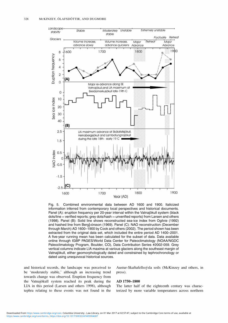