pequonnock river watershed management plan - … · pequonnock river watershed management plan ....
TRANSCRIPT

Pequonnock RiverWatershed Management Plan
July 2011
Prepared by
Pequonnock River Watershed Management Plan
Acknowledgements We would like to thank the following individuals and organizations for their contributions of time and effort to the development of this plan: Pequonnock River Initiative – Steering Committee Ron Bunovsky, Conservation & Water Resources Commission, Monroe Karen Burnaska, Conservation & Water Resources Commission, Monroe Gregg Dancho, Executive Director, Beardsley Zoo Michael Dietz, Program Director, CT Nonpoint Education for Municipal Officials Ted Grabarz, Sustainability Director, Bridgeport Steve Hladun, Bridgeport Parks & Recreation John Lauria, Inland Wetlands and Watercourses Commission, Trumbull Mary Ellen Lemay, Chair, Conservation Commission, Trumbull Bill Levin, Town Planner, Trumbull Marven Moss, Monroe Land Trust & Tree Conservancy Bill Quinn, Department of Health, Bridgeport Michael O’Reilly, Chair, Conservation & Water Resources Commission, Monroe Keith Rodgerson, City of Bridgeport Office of Planning & Economic Development Rich Rosen, Trout Unlimited Stephen Savarese, Town Engineer, Trumbull Scott Schatzlein, Town Engineer, Monroe Lois Spence, Inland Wetlands & Watercourses Commission, Monroe Lisa Trachtenburg, City Attorney, Bridgeport Jon Urquidi, City Engineer, Bridgeport Don Watson, Conservation Commission, Trumbull Pequonnock River Initiative – Agency Representatives MaryAnn Nusom-Haverstock, Connecticut Department of Energy and Environmental Protection Christopher Malik, Connecticut Department of Energy and Environmental Protection Roman Mrozinski, Southwest Conservation District Pequonnock River Initiative – Sub-Committees/Volunteers Christine Cook, Resident, Landscape Designer, Bridgeport Jack Dillon, Executive Director, Groundwork Bridgeport Chris German, CT Community Boating Association, Bridgeport Mary Keane, Trumbull Land Trust Sheri Neely, Fairfield County Environmental Justice Network Tony Pappantoniou, Housatonic Community College Julio Reinoso, Fairfield County Environmental Justice Network Volunteer Maggie Sackrider, Beardsley Zoo Paul Timpanelli, Executive Director, Bridgeport Regional Business Council David Wilgan, Trout Unlimited Gian Morresi, Trout Unlimited Jeanne Yuckienuz, Beardsley Zoo

Pequonnock River Watershed Management Plan
Pequonnock River Initiative – Coordinator Chris Cryder, Save the Sound/Connecticut Fund for the Environment Consultants/Contractors Erik Mas and Daniel Buttrick, Fuss & O’Neill Peter Fraboni and Dick Harris, Harbor Watch/River Watch program of EarthPlace Funding support for this plan was provided by the U.S. Environmental Protection Agency and Connecticut Department of Energy and Environmental Protection through a Nonpoint Source Management Grant under Section 319(h) of the Federal Clean Water Act and a Water Quality Management Planning Grant under section 604(b) of the Federal Clean Water Act, and by the City of Bridgeport. .

Table of Contents
Pequonnock River
Watershed Management Plan
Pequonnock River Watershed Management Plan i
Executive Summary .............................................................................1
1 Introduction .................................................................................1 1.1 Background ..................................................................................................1 1.2 Plan Development Process .........................................................................8 1.3 Public Outreach .........................................................................................11
2 Watershed Management Goals and Objectives ..................15 2.1 Watershed Management Goals ...............................................................15 2.2 Watershed Management Objectives ......................................................15
2.2.1 Goal 1 – Capacity Building for Plan Implementation .................16 2.2.2 Goal 2 – Water Quality .....................................................................16 2.2.3 Goal 3 – Habitat Protection and Restoration...............................17 2.2.4 Goal 4 – Sustainable Land Use and Open Space.......................17 2.2.5 Goal 5 – Education and Stewardship............................................17
3 Plan Recommendations ...........................................................18 3.1 Capacity Building for Plan Implementation ............................................19
3.1.1 Endorse the Plan and Establish a Watershed Organization ......19 3.1.2 Identify and Secure Funding ...........................................................21 3.1.3 Promote Regional Collaboration ...................................................21 3.1.4 Continue Watershed Field Assessments ........................................22
3.2 Water Quality..............................................................................................23 3.2.1 Continue Water Quality Monitoring...............................................23 3.2.2 Promote Low Impact Development and Green Infrastructure 24 3.2.3 Implement Stormwater Retrofits .....................................................32 3.2.4 Implement MS4 Stormwater Management Programs................37 3.2.5 Restore and Protect Riparian Buffers .............................................38 3.2.6 Reduce the Impacts of Subsurface Sewage Disposal Systems 41 3.2.7 Reduce Nuisance Waterfowl ..........................................................42 3.2.8 Identify and Eliminate Illicit Discharges .........................................43 3.2.9 Reduce Impacts from Hotspot Land Uses.....................................45
3.3 Habitat Protection and Restoration ..........................................................46 3.3.1 Protect and Restore Aquatic and Stream Corridor Habitat......46 3.3.2 Protect and Restore Forests and Watershed Tree Canopy .......50 3.3.3 Manage Invasive Plant Species......................................................51 3.3.4 Conduct Cleanups and Discourage Illegal Dumping................52
3.4 Sustainable Land Use and Open Space..................................................54 3.4.1 Strengthen Land Use Regulations...................................................54 3.4.2 Promote Sustainable Development...............................................64

Table of Contents
Pequonnock River
Watershed Management Plan
Pequonnock River Watershed Management Plan ii
3.4.3 Address Flooding ...............................................................................65 3.4.4 Preserve and Protect Open Space................................................66 3.4.5 Link Green Spaces ............................................................................68 3.4.6 Increase Public Access to the River ...............................................70
3.5 Education and Stewardship ......................................................................71 3.5.1 Create Pequonnock River Initiative Web Site ..............................72 3.5.2 Improve Local Government Awareness of Municipal Practices and Opportunities for Watershed Protection...............................72 3.5.3 Provide Outreach and Education to the Business Community 74 3.5.4 Conduct Outreach and Education for Parks and Institutional Land Owners......................................................................................75 3.5.5 Conduct Homeowner Outreach and Education........................76 3.5.6 Enhance School Education and Stewardship Programs ...........79
4 Site-Specific Project Concepts ................................................81 4.1 Wolfe Park Stormwater and Buffer Improvements ..................................81 4.2 Stepney Elementary School Greenscaping ............................................86 4.3 Bart Shopping Center LID Retrofits ............................................................89 4.4 Beardsley Park LID Retrofits .......................................................................91 4.5 Bridgeport City Hall LID Retrofits ...............................................................94 4.6 Green/Complete Streets ...........................................................................97 4.7 Trumbull Public Library LID.........................................................................99 4.8 Old Mine Park Restoration.......................................................................100 4.9 Knowlton Park...........................................................................................102 4.10 Regional Stormwater Retrofits .................................................................104 4.11 Water Street Green Infrastructure...........................................................106
5 Pollutant Load Reductions......................................................108
6 Schedule, Milestones, and Evaluation Criteria ....................116
7 Funding Sources ......................................................................116
8 References ...............................................................................116

Table of Contents
Pequonnock River
Watershed Management Plan
Pequonnock River Watershed Management Plan iii
Tables Page 3-1 Green Infrastructure Practices 25 3-2 Potential Stormwater Retrofit Opportunities 33 3-3 Potential Buffer Restoration Opportunities 39 3-4 Potential Stream Restoration Opportunities 48 3-5 Focus Areas for Potential Stream Cleanups 53 5-1 Anticipated Annual Pollutant Load Reductions 111 5-2 Anticipated Annual Pollutant Load Reductions of Varying Levels of Green
Infrastructure/LID Retrofits 111 5-3 Summary of Modeled Pollutant Loads and Load Reductions 112 Figures Page 1-1 Pequonnock River Watershed 3 1-2 Watershed Aerial Photograph 4 1-3 Water Quality Impairments 5 1-4 Priority Subwatersheds Targeted for Field Inventories` 10 3-1 Examples of Low Impact Development Practices 27 3-2 Examples of Green Infrastructure Practices 28 3-3 High Priority Potential Stormwater Retrofits and Target Areas 35 3-4 Lower Priority Potential Stormwater Retrofit Areas 36 3-5 Open Space Priority Parcels 69 4-1 Wolfe Park LID Retrofit Concept Plan 82 4-2 Existing Conditions at the Westerly Stream Entering Great Hollow Lake 84 4-3 Proposed Stream Restoration Concept 85 4-4 Existing Conditions and Proposed Concept for Great Hollow Lake Shoreline
Restoration 85 4-5 Typical Bank Restoration Planting for Small Streams 86 4-6 Stepney Elementary School Greening Concept 87 4-7 Diagram of Selected Permeable Pavement Systems 88 4-8 Bart Shopping Center LID Retrofit Concept 89 4-9 Typical Green Gutter Cross Section 90 4-10 Typical Pervious Parking Row Cross Section 90 4-11 LID Retrofit Concept for Beardsley Park 92 4-12 Typical Tree Box Filter 93 4-13 Beardsley Zoo Rain Gardens and Tree Box Filter Retrofit Concept 94 4-14 Bridgeport City Hall Green Roof Retrofit Concept 95 4-15 Modular Green Roof System Installation 95 4-16 Bridgeport City Hall LID Retrofit Concept 96 4-17 Typical Pervious Pavement Parking Stall 97 4-18 Green/Complete Street Concept Site Plan 97
Table of Contents
Pequonnock River
Watershed Management Plan
Pequonnock River Watershed Management Plan iv
Figures Page 4-19 Green/Complete Street Concept for Lincoln Boulevard 98 4-20 Green/Complete Street Cross Section 98 4-21 Trumbull Library LID Concept 99 4-22 Old Mine Park Restoration Concept Site Plan 101 4-23 Old Mine Park Restoration Concept Rendering 101 4-24 Knowlton Park – Existing Conditions 102 4-25 Knowlton Park Proposed Concept Plan 103 4-26 Slawson Street and Hawley Avenue Retrofit Areas 104 4-27 Route 8 and Housatonic Avenue Retrofit Areas 105 4-28 Water Street Green Infrastructure Concept Plan 106 4-29 Water Street Green Infrastructure Concept Rendering 107 5-1 Anticipated Nitrogen Loads and Load Reductions 113 5-2 Anticipated Phosphorus Loads and Load Reductions 113 5-3 Anticipated Sediment (TSS) Loads and Load Reductions 114 5-4 Anticipated Fecal Coliform Loads and Load Reductions 114 5-5 Anticipated Runoff Volumes and Volume Reductions 115 Appendices End of Document A Baseline Watershed Assessment Report (on CD) B Watershed Field Assessment Report (on CD) C Maps of Subwatershed Recommendations D Open Space Priority Parcel Assessment E Site-Specific Project Cost Estimates F Pollutant Load Reduction Model Results G Implementation Schedule, Milestones, and Evaluation Criteria H Potential Funding Sources
Pequonnock River Watershed Management Plan ES-1
Executive Summary The Pequonnock River watershed is an approximately 29 square-mile drainage area in the southwestern portion of Connecticut. The watershed is located within five communities, with the majority of the watershed located within the Town of Monroe, the Town of Trumbull, and the City of Bridgeport. The Pequonnock River begins at its headwaters in Monroe and flows in a south-southeasterly direction through the center of Trumbull and the northern neighborhoods of the City of Bridgeport on its way to inner Bridgeport Harbor. The river becomes tidal just upstream of its confluence with Island Brook and continues flowing along the East Side and Downtown Bridgeport neighborhoods until converging with Yellow Mill Channel within Bridgeport Harbor and ultimately Long Island Sound. Land use within the watershed varies from undeveloped or lightly developed areas near the headwaters in Monroe, portions of which serve as a backup drinking water supply; transitioning to low- and medium-density residential and commercial uses through Trumbull and the northern portions of Bridgeport; and finally to the City center and former industrial and manufacturing uses near the mouth of the river at Bridgeport Harbor. Issues Facing the Watershed The water quality in approximately 80% of the Pequonnock River currently does not meet minimum standards for recreation or habitat for fish, other aquatic life, and wildlife. These “impaired” reaches of the Pequonnock River include an approximately 2.4-mile segment in Monroe between Stepney Pond and Great Hollow Lake in Wolfe Park, impaired due to elevated levels of indicator bacteria, and approximately the lower two-thirds of the river through most of Trumbull and Bridgeport, which does not meet standards for supporting a healthy macroinvertebrate community due to unknown causes and sources. The poor water quality in these impaired segments of the Pequonnock River is generally the result of historical land use and urbanization within the watershed. The tidal portions of the river and Bridgeport Harbor also do not currently meet current standards for commercial shellfish harvesting, recreational uses, and habitat due to elevated levels of indicator bacteria resulting from discharges of combined sewer overflows, urban stormwater runoff, historical sediment contamination of former industrial uses in the lower watershed, waterfowl, marina/boating sanitary on-vessel discharges, and other nonpoint sources (CT DEEP, 2011). The degraded water quality conditions in Bridgeport Harbor currently prevent harvesting of shellfish for most uses. Flooding is also common along the Pequonnock River and many of its tributaries. In the City of Bridgeport, most areas adjacent to the river are subject to recurring flooding problems due to dense urban development. Flooding along the river corridor in Trumbull is exacerbated by the steep topography and limited floodplain storage in this portion of the river valley, while the lowlands adjacent to the upper reaches of the Pequonnock River in Monroe are also subject to frequent flooding during major storms.

Pequonnock River Watershed Management Plan ES-2
The Need for a Comprehensive Watershed-Based Plan The watershed communities and the Connecticut Department of Energy and Environmental Protection (CT DEEP) recognize the need to address the water resource issues of the Pequonnock River and its tributaries using a watershed-based approach. A primary way to do this is by developing and implementing a comprehensive watershed management plan to protect and restore water resource conditions throughout the watershed. During the summer of 2010 the Pequonnock River Initiative (PRI) was formed as a partnership between the City of Bridgeport and the Towns of Monroe and Trumbull to develop a watershed plan for the Pequonnock River watershed. The City of Bridgeport, through a Section 319 grant from the CT DEEP, retained Fuss & O’Neill, Inc. to perform the technical components of the watershed plan development. The CT DEEP also awarded a Section 604(b) grant of the American Recovery and Reinvestment Act to Save the Sound, a program of Connecticut Fund for the Environment, Inc. and the Southwest Conservation District. Save the Sound led the formation of a watershed coalition, organizing workshop meetings, assisting in the development of the watershed plan recommendations, and performing public education and outreach. The primary objective of this watershed management plan is to identify specific, measurable actions that will address the water quality impairments in the Pequonnock River and Bridgeport Harbor in order to restore the recreation and habitat uses that have been lost due to degraded water quality. While water quality is a primary focus of this plan, flooding is also addressed as a related issue, along with habitat protection and restoration. Plan Development Process The Watershed Action Plan has been developed consistent with State and Federal guidance for the development of watershed-based plans. Following this approach will enable implementation projects under this plan to be considered for funding under Section 319 of the Clean Water Act and improve the chances for funding through other State and Federal sources. Development of the watershed management plan consisted of the following major tasks.
• Steering Committee – A steering committee consisting of representatives of the PRI was formed to guide the plan development. The watershed management plan reflects the combined efforts of the PRI, watershed municipalities, the Save the Sound and Fuss & O’Neill project team, the CT DEEP, and other stakeholders.
• Baseline Watershed Assessment – A baseline assessment was performed to develop an
understanding of the current water resource conditions in the Pequonnock River watershed. The baseline assessment serves as a basis for the watershed management plan recommendations and also provides a background reference document to support future implementation activities within the watershed.
• Watershed Field Inventories – Field inventories were conducted in approximately eight
miles of stream corridors, potential hotspot land use locations, representative residential neighborhoods, and associated streets and storm drainage systems. The field inventories

Pequonnock River Watershed Management Plan ES-3
identified a number of common issues and problems, as well as potential candidate sites for stormwater retrofits, stream restoration, and other targeted projects. The Watershed Field Assessment Report also serves as a basis for watershed plan recommendations, as well as a background reference document to support future plan implementation activities.
• Land Use Regulatory Review – The project team also reviewed the land use regulations
and planning documents of Monroe, Trumbull, and Bridgeport. The land use regulatory review identified a number of recommendations to improve stormwater management, promote green infrastructure and Low Impact Development (LID), reduce the amount of impervious cover generated by future development, and better protect watercourses, wetlands, and riparian areas.
• Plan Goals and Objectives – The project team developed a series of goals and
objectives for the watershed based upon the findings of the baseline watershed assessment, field inventories, and land use regulatory review. The goals and objectives were further refined by the PRI Steering Committee with input from each of the watershed municipalities.
• Plan Recommendations – Potential management actions were identified for each of the
plan goals and objectives and subsequently refined based upon input from the PRI Steering Committee through workshop meetings and coordination with municipal staff and boards, culminating in the plan recommendations that are presented in this document. Management actions included ongoing, short, medium and long-term recommendation, as well as watershed-wide and site-specific actions. Site-specific retrofit and restoration concepts were developed based on the baseline assessment and watershed field inventories.
• Public Outreach – Significant public outreach was conducted during the watershed
planning process to increase public understanding of issues affecting the watershed and to encourage participation in the development of the watershed plan.
Watershed Management Goals The watershed management goals for the Pequonnock River watershed are:
• Goal 1 – Capacity Building for Plan Implementation. Build a foundation for successful implementation of the watershed management plan by the watershed municipalities, non-governmental organizations (environmental groups and non-profits), residents, local businesses, and other stakeholders.
• Goal 2 – Water Quality. Improve the water quality of the Pequonnock River and its
tributaries so that impaired reaches of the river will consistently meet their designated uses for fish and wildlife habitat and recreational use, along with improving the downstream water bodies of Bridgeport Harbor and Long Island Sound. Maintain and enhance the water quality of water bodies that are not impaired.

Pequonnock River Watershed Management Plan ES-4
• Goal 3 – Habitat Protection and Restoration. Protect and improve terrestrial, riparian, and aquatic habitat in the watershed to maintain and increase the watershed’s diversity of plant and animal species.
• Goal 4 – Sustainable Land Use and Open Space. Promote sustainable growth and
appropriate development in the watershed while preserving and improving the watershed’s natural resources, providing public access to open space, and addressing current and future flooding problems.
• Goal 5 – Education and Stewardship. Promote stewardship of the Pequonnock River
watershed through education and outreach. Target appropriate messages to specific audiences, and promote stewardship opportunities through citizen involvement in science, conservation, and restoration activities.
Summary of Recommendations A set of specific objectives and recommended actions were developed to satisfy the management goals for the watershed. The plan recommendations include watershed-wide recommendations that can be implemented throughout the Pequonnock River watershed, targeted recommendations that are tailored to issues within specific subwatersheds or areas, and site-specific recommendations to address issues at selected sites that were identified during the watershed field inventories. Recommendations are classified according to their timeframe and overall implementation priority.
• Ongoing Actions are actions that should occur annually or more frequently such as routine water quality monitoring, as well as actions that occur on an ongoing basis such as fundraising, education and outreach, and coordination between watershed stakeholders.
• Short-Term Actions are initial actions to be accomplished within the first one to two
years of plan implementation. These actions have the potential to demonstrate immediate progress and success and/or help establish the framework for implementing subsequent plan recommendations. Such actions include adoption of the plan by the watershed municipalities and formation of a watershed organization; revising local land use regulations; outfall inventories and illicit discharge investigations; and field inventories within previously unassessed subwatersheds. Small demonstration projects could be completed during this phase, with volunteer service events. Construction of larger retrofits and restoration projects requiring extensive design, engineering, and permitting should be planned for later implementation.
• Mid-Term Actions involve continued programmatic and operational measures, delivery
of educational and outreach materials, and construction of larger retrofit and/or restoration projects over the next two to five years. Progress on land conservation, especially the protection of headwaters and unique landscapes, LID and green infrastructure implementation, and discharge investigation follow-up activities should be completed during this period, as well as project monitoring and tracking. A sustainable funding and maintenance program should also be established for watershed-wide green

Pequonnock River Watershed Management Plan ES-5
infrastructure programs and implementation of stormwater retrofits through regional collaboration.
• Long-Term Actions consist of continued implementation of additional projects
necessary to meet watershed objectives, as well as an evaluation of progress, accounting of successes and lessons learned, and an update of the watershed management plan. Long-term recommendations are intended to be completed during the next 5- to 10-year timeframe and beyond. The feasibility of long-term project recommendations, many of which involve significant infrastructure improvements, depends upon the availability of sustainable funding programs and mechanisms.
Priority Actions for the Pequonnock River Watershed The actions in the following table are a subset of the over 100 recommended actions that have been identified in this watershed management plan. These “priority” recommendations are actions that are most critical to the success of this watershed plan and will have the greatest benefit to water resource conditions in the Pequonnock River and its watershed. The table lists the related plan goals and includes references to specific sections of the plan for more information on each recommendation.
Priority Action Related Goal For More Information
1. Adopt the watershed plan through a formal agreement between the municipalities. Form a watershed organization with representatives from Monroe, Trumbull, and Bridgeport.
Capacity Building Section 3.1.1
2. Actively seek and obtain funding to implement plan recommendations. Capacity Building Section 3.1.2
3. Establish an ongoing water quality monitoring program for the watershed. Water Quality Section 3.2.1 4. Continue to implement the City of Bridgeport Long Term Control Plan to
reduce Combined Sewer Overflow discharges to the river and harbor. Water Quality Section 3.2.2
5. Promote green infrastructure and low impact development for private development and municipal infrastructure. Incorporate green infrastructure approaches in the City’s CSO control efforts.
Water Quality Section 3.2.2
6. Implement priority stormwater retrofits, beginning with high-profile demonstration sites in each watershed community. Water Quality Section 3.2.3
Section 4
7. Implement priority stream buffer restoration projects, and adopt local stream buffer regulations.
Water Quality; Land Use and Open Space
Section 3.2.5 Section 3.4.1
8. Protect and restore aquatic and stream corridor habitat by implementing priority fish passage and stream restoration projects.
Habitat Protection
and Restoration
Section 3.3.1
9. Pursue the creation of a regional sewer authority to establish a regional framework for addressing septic system impacts and potential stormwater funding mechanisms.
Water Quality Section 3.2.6
10. Strengthen municipal land use regulations to improve stormwater management using low impact development, riparian buffer protection, and tree canopy preservation.
Land Use and Open Space Section 3.4.1

Pequonnock River Watershed Management Plan ES-6
Priority Action Related Goal For More Information
11. Increase public access to the river to enhance recreational opportunities and stewardship of the river. Recapture the riverfront along the Lower Pequonnock River through redevelopment efforts such as Knowlton Street Park, which can serve as a catalyst for broader economic development.
Land Use and Open Space Section 3.4.6
12. Promote public education and stewardship of the watershed through continuing engagement activities, such as clean-ups, stream condition assessments, invasive plant removals, streambank buffer plantings, and river festivals/events. Create an interactive web-site and social media tools to inform the public about the watershed plan, watershed issues, and stewardship opportunities.
Education and Outreach Section 3.5

Pequonnock River Watershed Management Plan 1
1 Introduction 1.1 Background
Watershed Overview The Pequonnock River watershed1 is an approximately 29 square-mile sub-regional basin within the Southwest Coast major basin in the southwestern portion of Connecticut (Figure 1-1). The watershed is located within five communities, with the majority of the watershed (approximately 96%) located within the Town of Monroe, the Town of Trumbull, and the City of Bridgeport. The watershed includes all of the land area that drains to the non-tidal and tidal portions of the Pequonnock River upstream of the Interstate 95 bridge crossing over Bridgeport Harbor. The Pequonnock River begins at its headwaters in Monroe and flows in a south-southeasterly direction through the center of Trumbull and the northern neighborhoods of the City of Bridgeport on its way to inner Bridgeport Harbor. The river becomes tidal just upstream of its confluence with Island Brook and continues flowing along the East Side and Downtown Bridgeport neighborhoods until converging with Yellow Mill Channel within Bridgeport Harbor and ultimately Long Island Sound. Land use within the watershed trends from undeveloped or lightly developed areas near the headwaters in Monroe, portions of which serve as a backup drinking water supply; to low- and medium-density residential and commercial uses along with protected open space through
Trumbull and the northern portions of Bridgeport; and finally to the City center and former industrial and manufacturing uses near the mouth of the river at Bridgeport Harbor (Figure 1-2). Transportation corridors within the watershed include several heavily-travelled state routes (State Routes 8, 25, and 15) as well as Interstate 95 and U.S. Route 1. These transportation corridors are generally located in the lower third of the watershed, although Route 25 follows the Pequonnock River for much of its length, with several river crossings.
1 A watershed is the area of land that contributes runoff to a specific receiving water body such as a lake, river, stream, wetland, estuary, or bay.

Pequonnock River Watershed Management Plan 2
Issues Facing the Watershed Based on water quality monitoring conducted by the Connecticut Department of Energy and Environmental Protection (CT DEEP, formerly the Connecticut Department of Environmental Protection or CT DEEP) and the Harbor Watch/River Watch program, the water quality in approximately 80% of the Pequonnock River currently does not meet minimum standards for recreation or habitat for fish, other aquatic life, and wildlife. These “impaired” reaches of the Pequonnock River include an approximately 2.4-mile segment in Monroe between Stepney Pond and Great Hollow Lake in Wolfe Park, impaired due to elevated levels of indicator bacteria, and approximately the lower two-thirds of the river through most of Trumbull and Bridgeport, which does not meet standards for supporting a healthy macroinvertebrate community (Figure 1-3) due to unknown causes and sources. The poor water quality in these impaired segments of the Pequonnock River is generally the result of historical land use and urbanization within the watershed. It is important to note that not all segments of the Pequonnock River have been assessed for support of aquatic life or recreation due to limited data; segments of the river that have not been formally assessed by the CT DEEP may also not meet Water Quality Standards. The tidal portions of the river and Bridgeport Harbor (Figure 1-3) also do not currently meet current standards for commercial shellfish harvesting, recreational uses, and habitat due to elevated levels of indicator bacteria resulting from discharges of combined sewer overflows (CSO), urban stormwater runoff, historical sediment contamination of former industrial uses in the lower watershed, waterfowl, marina/boating sanitary on-vessel discharges, and other nonpoint sources (CT DEEP, 2011). The degraded water quality conditions in Bridgeport Harbor currently prohibit harvesting of shellfish for uses other than depuration in other waters or aquaculture purposes. A primary focus of this watershed-based management plan is to address the water quality impairments in the Pequonnock River and Bridgeport Harbor in order to restore the recreation and habitat uses that have been lost due to degraded water quality. Similar to watershed-based plans, Total Maximum Daily Loads (TMDLs) provide a quantitative framework to restore impaired waters by establishing the maximum amount of a pollutant that a water body can assimilate without adverse impact to aquatic life, recreation, or other public uses. For impaired waters, the TMDL also establishes pollutant load reduction targets for the water body to attain water quality standards. The CT DEEP has identified the need to develop TMDLs to address the impairments in the Pequonnock River and Bridgeport Harbor. The end result of the TMDL process is a water quality management plan with quantitative goals to reduce pollutant loadings to the impaired water body. Future TMDL implementation for the Pequonnock River and Bridgeport Harbor can build upon the recommendations of this watershed-based management plan. Ultimately, the goal of both the watershed-based plan and future TMDLs is to improve water quality of the impaired segments to meet water quality standards and remove the Pequonnock River and Bridgeport Harbor from the impaired waters list.

Figure 1-1. Pequonnock River Watershed

Figure 1-2. Watershed Aerial Photograph

Figure 1-3. Water Quality Impairments

Pequonnock River Watershed Management Plan 6
Flooding is also common along the Pequonnock River and many of its tributaries. In the City of Bridgeport, most areas adjacent to the river are subject to recurring flooding problems due to dense urban development. Flooding along the river corridor in Trumbull is exacerbated by the steep topography and limited floodplain storage in this portion of the river valley, while the lowlands adjacent to the upper reaches of the Pequonnock River in Monroe are also subject to frequent flooding during major storms. While water quality is the primary focus of this watershed management plan, flooding is also addressed as a related issue, along with habitat protection and restoration. Watershed Stewardship Efforts The City of Bridgeport, the Towns of Trumbull and Monroe, the CT DEEP, and other groups, through the Pequonnock River Initiative (PRI), have begun to address the water resource issues facing the Pequonnock River and its watershed. Notable ongoing and planned water resource-related stewardship efforts, including conservation and restoration projects, within the Pequonnock River watershed are summarized below.
• An Alaskan steep-pass fishway was constructed by the City of Bridgeport at the Bunnell’s Pond dam in 2002 to allow fish passage along the lower Pequonnock River upstream of Bunnell’s Pond dam. The dam is currently owned by the State of Connecticut and operated by the CT DEEP and is reported to be the tallest steep-pass fishway on the east coast. Thousands of blueback and river herring are estimated to use the fishway each year. Pending the availability of future funding, the CT DEEP plans to install a camera at the fishway to count and identify fish and educate the general public. Bunnell’s Pond dam also has an eel pass. Eels are captured in a holding tank and are then transported upstream by CT DEEP staff to the pond. CT DEEP is working to modify the eel pass configuration to improve eel passage at this location.
• Save the Sound in conjunction with the CT DEEP and U.S. Fish and Wildlife Service
received funding to address a significant obstruction to fish passage in the lower portion of the Pequonnock River in Bridgeport, just downstream of Bunnell’s Pond. When the highway was constructed, approximately 12 feet of the river was turned into a smooth concrete channel below the Route 8 bridge. The flow in the river is so shallow that river herring and blueback herring cannot pass safely below the bridge at times. The objective of this project is to create a fish ladder in the existing concrete apron to restore safe passage of river herring and other resident fish species to the Bunnell’s Pond fishway and upstream reaches within the watershed. Construction of the project, referred to as the Pequonnock River Apron Fishway, is anticipated to begin in 2011.
• The City of Bridgeport is implementing an ambitious city-wide sustainability initiative
through its BGreen 2020 sustainability master plan. The plan includes a number of water resource-related programs including the use of green infrastructure to address combined sewer overflows and stormwater management through stormwater retrofits at vacant or underutilized parcels, water conservation as well as stormwater harvesting and reuse, and integration of stormwater management and public infrastructure improvements through the City’s “complete streets” policy.

Pequonnock River Watershed Management Plan 7
• The City of Bridgeport is undertaking a “complete streets” program as part of its city-wide sustainability initiatives. Complete streets or “green streets” integrate bicycle and pedestrian opportunities, along with automobile lanes, as well as incorporate landscaping and green infrastructure stormwater management elements into public infrastructure projects. Complete streets projects are planned along Park Avenue and the Park Avenue/Railroad Avenue areas of the City. The plan also promotes related programs that will benefit the Pequonnock River watershed including a street tree and urban forestry initiative, programs to increase and enhance open spaces and recreation, and enhanced public access to the river through waterfront redevelopment.
• Connecticut Fund for the Environment, in partnership with the Natural Resources
Defense Council, has received funding through a CT DEEP Supplemental Environmental Project to assess the feasibility of green infrastructure implementation in two Connecticut cities, including Bridgeport. The project seeks to identify real-world green infrastructure opportunities, determine the cost of implementing those improvements, and align the potential stormwater flow control solutions with needed CSO flow reduction to determine the overall benefit green infrastructure could provide. The study would include a cost-benefit analysis and identify financing options, incentives, and disincentives that could be specifically employed. The goal is to assess the actual financial savings and environmental enhancement green infrastructure could support.
• The City of Bridgeport is embarking on developing a new parks or “green spaces”
master plan to provide for linkages between green spaces, and at the same time protect the integrity of Bridgeport’s natural resources and natural systems.
• A key component of the City of Bridgeport’s revitalization efforts is increasing
waterfront access opportunities along its coastline including the Pequonnock River. The City is pursuing several opportunities along the lower Pequonnock River to provide public access to the river by redeveloping vacant or underutilized former industrial sites for passive recreation and other mixed-uses.
• The City of Bridgeport is exploring opportunities to integrate green infrastructure
approaches into its combined sewer overflow (CSO) control plan. The Bridgeport Water Pollution Control Authority has developed plans for capital improvements to separate combined sanitary/stormwater system in certain areas to limit CSO discharges into the city’s waterways. Implementation of green infrastructure approaches within the public realm (i.e., expansion of the urban tree canopy, incorporation of rain gardens and swales into street design, and the use of permeable pavement) is also being considered to reduce the frequency and volume of overflows and mitigate some of the need for high-cost sewer separation.
• The Regional Bicycle Plan for the Greater Bridgeport Planning Region includes a
concept to develop a continuous and interconnected multi-use trail for bicyclists and pedestrians from the Water Street Dock in Bridgeport to the Newtown town line. The approximate 15-mile trail includes a section along the Pequonnock River Valley through

Pequonnock River Watershed Management Plan 8
Monroe and Trumbull as well as Glenwood Park, Beardsley Park, and Waterfront Park in Bridgeport. Portions of the trail system have been completed, while others are in deign or construction.
• Researchers at Yale University School of Architecture, School of Forestry &
Environmental Studies are working on a green infrastructure demonstration project in the Seaside Village section of Bridgeport. The project is exploring ways to integrate Low Impact Development stormwater management practices such as water quality swales and bioretention into the existing streetscape and yards of this planned community. Concepts that are developed as part of this project could potentially be applied elsewhere in the City and in the Pequonnock River watershed.
The Need for a Comprehensive Watershed Plan The watershed communities and the CT DEEP recognize the need to address the water resource issues of the Pequonnock River and its tributaries using a watershed-based approach. A primary way to do this is by developing and implementing a comprehensive watershed management plan to protect and restore water resource conditions throughout the watershed. During the summer of 2010 the Pequonnock River Initiative (PRI) was formed as a partnership between the City of Bridgeport and the Towns of Monroe and Trumbull to develop a watershed plan for the Pequonnock River watershed. The City of Bridgeport, through a Section 319 grant from the CT DEEP, retained Fuss & O’Neill, Inc. to perform the technical components of the watershed plan development. The CT DEEP also awarded a Section 604(b) grant of the American Recovery and Reinvestment Act to Save the Sound, a program of Connecticut Fund for the Environment, Inc. and the Southwest Conservation District. Save the Sound led the formation of a watershed coalition, organizing workshop meetings, assisting in the development of the watershed plan recommendations, and performing public education and outreach. The objective of this watershed management plan is to characterize the watershed conditions, identify, investigate, and address the current and emerging issues facing the watershed, and have the clear potential to affect on-the-ground change within the watershed by recommending specific, measurable actions to protect and improve water resource conditions.
1.2 Plan Development Process
The Pequonnock River Watershed Management Plan is the culmination of desktop analyses and field assessments performed by the project team under the direction of the PRI and the project Steering Committee. The plan synthesizes information from earlier studies and reports on the watershed, Geographical Information System (GIS) mapping and analyses, review of land use regulations, and detailed field assessments to document baseline watershed conditions, the potential impacts of future development in the watershed, and recommended actions to protect and restore water resource conditions.

Pequonnock River Watershed Management Plan 9
The watershed management plan has been developed consistent with the U.S. Environmental Protection Agency (EPA) and CT DEEP guidance for the development of watershed-based plans. The guidance outlines nine key elements that establish the structure of the plan, including specific goals, objectives, and strategies to protect and restore water quality; methods to build and strengthen working partnerships; a dual focus on addressing existing problems and preventing new ones; a strategy for implementing the plan; and a feedback loop to evaluate progress and revise the plan as necessary. Following this approach will enable implementation projects under this plan to be considered for funding under Section 319 of the Clean Water Act and improve the chances for funding through other State and Federal sources. Development of the watershed management plan consisted of the following major tasks.
• Steering Committee – A steering committee consisting of representatives of the PRI was formed to guide the plan development. Municipal liaisons from each of the three watershed communities were identified to interface with municipal staff and boards during the plan development process. A series of workshop meetings were held with the PRI Steering Committee to reach consensus on watershed planning goals and objectives and to discuss specific recommended actions. The steering committee also guided the plan development process by providing review comments on draft deliverables. The watershed management plan reflects the combined efforts of the PRI, watershed municipalities, the Save the Sound and Fuss & O’Neill project team, the CT DEEP, and other stakeholders. Members of the PRI Steering Committee and others involved in the plan development process are listed in the Acknowledgments section at the beginning of this document.
• Baseline Watershed Assessment – A baseline assessment was performed to develop an
understanding of the current water resource conditions in the Pequonnock River watershed. The project team reviewed existing watershed data, studies, and reports; compiled and analyzed GIS mapping of the watershed and various subwatersheds; and developed pollutant loading and impervious cover models to evaluate areas in the watershed that are at-risk from future development. A comparative subwatershed analysis was also performed to identify the subwatersheds that 1) are more sensitive to future development and should be the focus of watershed conservation efforts to maintain existing high-quality resources and conditions and 2) are likely to have been impacted and have greater potential for restoration to improve or enhance existing conditions. The baseline assessment serves as a basis for the watershed management plan recommendations and also provides a background reference document to support future implementation activities within the watershed. A copy of the Baseline Watershed Assessment Report is provided on CD in Appendix A of this plan.
• Watershed Field Inventories – The results of the comparative subwatershed analysis
were used to target individual subwatersheds for detailed field inventories (Figure 1-4). Using screening-level assessment procedures developed by the Center for Watershed Protection and EPA, field crews assessed approximately eight miles of stream corridors, eighteen potential hotspot locations, thirteen representative residential neighborhoods, and associated streets and storm drainage systems. The field inventories identified a number of common issues and problems, as well as potential candidate sites for

Figure 1-4. Priority Subwatersheds Targeted for Field Inventories

Pequonnock River Watershed Management Plan 11
stormwater retrofits, stream restoration, and other targeted projects. The Watershed Field Assessment Report also serves as a basis for watershed plan recommendations, as well as a background reference document to support future implementation activities. A copy of the report is provided on CD in Appendix B of this plan.
• Land Use Regulatory Review – The project team also reviewed the land use regulations
and planning documents of the three watershed communities that comprise the majority of the land area in the watershed – Monroe, Trumbull, and Bridgeport. The land use regulatory review identified a number of recommendations to improve stormwater management, promote green infrastructure and Low Impact Development (LID), reduce the amount of impervious cover generated by future development, and better protect watercourses, wetlands, and riparian areas. Land use regulatory review recommendations are identified for each of the three watershed municipalities in Section 3 of this watershed management plan.
• Plan Goals and Objectives – The project team developed a series of goals and
objectives for the watershed based upon the findings of the baseline watershed assessment, field inventories, and land use regulatory review. The goals and objectives were further refined by the PRI Steering Committee with input from each of the watershed municipalities.
• Plan Recommendations – Potential management actions were identified for each of the
plan goals and objectives and subsequently refined based upon input from the PRI Steering Committee through workshop meetings and coordination with municipal staff and boards, culminating in the plan recommendations that are presented in Section 3 of this document. Management actions included ongoing, short, medium and long-term recommendation, as well as watershed-wide and site-specific actions. Site-specific retrofit and restoration concepts were developed based on the baseline assessment and watershed field inventories.
1.3 Public Outreach
Significant public outreach was conducted during the watershed planning process to increase public understanding of issues affecting the watershed and to encourage participation in the development of the watershed plan. Monthly Steering Committee meetings were held and were open to the public. A web page about the PRI was created on the Southwest Conservation District’s web site. A database of approximately 200 volunteers and interested citizens was developed, and e-mail blasts about Pequonnock River news and happenings were sent out over the course of the project. The public meetings, events, and activities are outlined below:
• June, 2010 – The Pequonnock River Initiative kick-off meeting was held at the Bridgeport City Hall Annex with 42 people in attendance representing Bridgeport, Trumbull, and Monroe, several community organizations, as well as representatives from the EPA, Connecticut Department of Environmental Protection, and the Natural Resources Conservation Service.

Pequonnock River Watershed Management Plan 12
• August, 2010 – The Steering Committee was formed consisting of representatives from each of the three watershed towns, people from various town commissions ( Conservation, Inland/Wetlands, Planning), and also a number of other organizations (Save the Sound, Beardsley Zoo, Housatonic Community College, Bridgeport Regional Business Council, CT NEMO, EarthPlace of Westport)
• September, 2010
o Professors from Sacred Heart University, and students from Southern Connecticut State University and Yale, worked with Fuss & O’Neill to complete on-the-ground stream assessments of selected reaches of the Pequonnock River and its tributaries.
o The Harbor Watch/River Watch program of EarthPlace, using a number of college and local high school students, completed their 2010 water quality testing of the main stem of the Pequonnock River.
• October, 2010
o On October 9th, two clean-ups of the Pequonnock River in Bridgeport occurred, one at Bunnell’s Pond and one at the “swimming hole” adjacent to Quarry Road. Ninety-five (95) volunteers participated in these clean-ups, including the Bridgeport Chargers football team, Builders Beyond Borders, Public Ally, Bridgeport Rotary, Bridgeport Aquaculture School, Trout Unlimited, and members of the Pequonnock River Initiative. Over 450 lbs. of trash were collected.
o The Trumbull Historical Society and the Pequonnock River Initiative hosted a Pequonnock River walk and 60 people attended.
o As a result of the stream assessments, an active dry weather discharge was detected on a stormwater outfall pipe on Island Brook, a tributary of the Pequonnock. EarthPlace collected a water sample of this pipe and identified a very high E. Coli count, indicating the possibility of illegal sewage connections. The City of Bridgeport was notified, and they discovered that 7 homes on Lindley Street had illegal connections to the stormwater system. The City has taken action with the homeowners to rectify these connections.
o Members of the Pequonnock River Initiative met with State Representative T.R. Rowe at Twin Brooks Park in Trumbull to discuss the proposed streamflow protection regulations, which would have implications for certain rivers in the State of Connecticut.
• November, 2010
o On November 6th, a team of 18 hard-working volunteers from Trumbull, Central High in Bridgeport, and Trout Unlimited, along with teachers from Monroe and New Haven, and other volunteers from Easton, Cos Cob, and Stamford hoisted 1,000 pounds of trash out of the Pequonnock River from behind Trumbull Center on Route 127. Members of Trumbull's Town Council and Conservation Commission discovered a huge mound of beer cans and liquor bottles on the streambank directly adjacent to a condominium unit, and then called the police to perform an investigation.
Pequonnock River Watershed Management Plan 13
o On November 9th, a boat tour of the lower Pequonnock River, Bridgeport Harbor, Yellow Mill River, and Johnson’s Creek was organized for representatives of the Environmental Protection Agency, Connecticut’s Brownfield Remediation department, and Save the Sound, citizens of the East Side and East End, as well employees of Bridgeport and members of the Pequonnock River Initiative. The Harbormaster provided police boats for the tour. Following the tour, problematic issues facing the rivers and harbor were discussed, and a plan was developed to create a conference focusing on waterfront land use issues in Bridgeport.
• January, 2011 – A presentation about the Pequonnock River Initiative was given by Chris Cryder, Coordinator of the PRI, to the Conservation Commission of the Town of Trumbull.
• April, 2011 – The Coordinator of the PRI attended a meeting in Monroe to discuss the
purpose and outcomes of the PRI. Members of the Planning and Inland/Wetlands Commissions were in attendance, as well as various town employees.
• June, 2011
o Bridgeport waterfront land use workshops were held on June 3rd and June 29th. The workshops were sponsored by EPA Region 1, in partnership with Save the Sound, the City of Bridgeport, the Connecticut Department of Environmental Protection, the East End Community Council, and the Neighborhood Revitalization Committees of the East End and East Side. Business owners, concerned residents, not-for-profit groups, academic institution, and Bridgeport City employees were in attendance.
o On June 4th, a clean-up was performed of Island Brook, a tributary of the Pequonnock River and a common location for illegal dumping. Over a ton of trash and recycled materials were removed from Island Brook. Thirty five volunteers, including Mayor Finch, BuildOn students from Central High School, Beardsley Zoo’s Conservation Discovery Corps crew, and employees from AT&T helped to haul out tires, school desks, shopping carts, building materials, electronic equipment, and car parts
o On June 7th, the Pequonnock River Initiative, Groundwork Bridgeport, and the EPA Region 1 New England Regional Laboratory conducted water quality testing at 5 sites on the lower Pequonnock River. Groundwork students from Harding and Central High Schools, and the Bridgeport Aquaculture School, along with Jack Dillon, Executive Director of Groundwork, collected water samples and performed various measurements. Water samples were tested in the EPA’s mobile laboratory, and the students measured levels of dissolved oxygen, conductivity, ammonia, chlorine, and surfactants.
o On June 3-5, one hundred and fifty sophomore high school students from across Connecticut came together at the University of Bridgeport for the Hugh O’Brian Youth Leadership conference. A student from each of Connecticut’s school districts is chosen to participate in this 3-day conference in which they develop their leadership skills. Save the Sound discussed the challenges that face Bridgeport’s rivers and harbor and Long Island Sound. The students learned

Pequonnock River Watershed Management Plan 14
about combined sewer overflows, marine debris, and the importance of habitat restoration. The river herring run on the Pequonnock River was highlighted. Each student wrote a letter to their congressional representative on a topic related to Long Island Sound. Finally, the students converged on Seaside Park for a beach clean-up.
o On June 18th, Trout Unlimited led a cleanup of the Pequonnock River in Trumbull.

Pequonnock River Watershed Management Plan 15
2 Watershed Management Goals and Objectives
This section presents overall management goals for the watershed and specific objectives to achieve these goals. The goals and objectives were developed in conjunction with the Pequonnock River Initiative (PRI) Steering Committee. The goals and objectives reflect specific priorities identified by the watershed municipalities and other stakeholder groups based upon the results of the watershed assessment and evaluation phases of the project. Recommended actions to achieve these goals and objectives are presented in Section 3 of this plan.
2.1 Watershed Management Goals
The watershed management goals for the Pequonnock River watershed are: • Goal 1 – Capacity Building for Plan Implementation. Build a foundation for successful
implementation of the watershed management plan by the watershed municipalities, non-governmental organizations (environmental groups and non-profits), residents, local businesses, and other stakeholders.
• Goal 2 – Water Quality. Improve the water quality of the Pequonnock River and its
tributaries so that impaired reaches of the river will consistently meet their designated uses for fish and wildlife habitat and recreational use, along with improving the downstream water bodies of Bridgeport Harbor and Long Island Sound. Maintain and enhance the water quality of water bodies that are not impaired.
• Goal 3 – Habitat Protection and Restoration. Protect and improve terrestrial, riparian,
and aquatic habitat in the watershed to maintain and increase the watershed’s diversity of plant and animal species.
• Goal 4 – Sustainable Land Use and Open Space. Promote sustainable growth and
appropriate development in the watershed while preserving and improving the watershed’s natural resources, providing public access to open space, and addressing current and future flooding problems.
• Goal 5 – Education and Stewardship. Promote stewardship of the Pequonnock River
watershed through education and outreach. Target appropriate messages to specific audiences, and promote stewardship opportunities through citizen involvement in science, conservation, and restoration activities.
2.2 Watershed Management Objectives
Specific objectives associated with the watershed management goals are described below. Recommended management strategies to achieve the plan objectives, including implementation priority, schedule, costs, funding sources, and implementation responsibilities, are presented in later sections of this plan.

Pequonnock River Watershed Management Plan 16
2.2.1 Goal 1 – Capacity Building for Plan Implementation
• Objective 1-1. Establish a watershed organization to coordinate and oversee the implementation of the watershed management plan and promote inter-municipal coordination.
• Objective 1-2. Identify and secure funding to implement the recommendations outlined
in this plan.
• Objective 1-3. Promote regional collaboration with other watershed organizations in Connecticut and around Long Island Sound to share ideas and strengthen regional watershed management efforts.
• Objective 1-4. Continue watershed field assessments to document future changes in
watershed conditions, evaluate previously unassessed areas, identify additional retrofit/restoration opportunities, and involve the public and volunteers as a form of outreach.
2.2.2 Goal 2 – Water Quality
• Objective 2-1. Continue water quality monitoring programs to identify pollution sources, follow long-term trends in water quality, and track the progress of the watershed management plan.
• Objective 2-2. Reduce the impacts of stormwater on hydrology and water quality
through the use of Low Impact Development (LID) practices and Green Infrastructure approaches.
• Objective 2-3. Implement municipal stormwater management programs to comply with
state and federal permit requirements. • Objective 2-4. Protect existing and restore degraded riparian buffers.
• Objective 2-5. Reduce the impacts of pollutant loadings from failing or malfunctioning
subsurface sewage disposal systems.
• Objective 2-6. Reduce overpopulation of nuisance waterfowl in key areas
• Objective 2-7. Identify and remove illicit wastewater and non-stormwater discharges into the Pequonnock River and its tributaries.
• Objective 2-8. Reduce the threats to water quality from land uses with higher pollution
potential and hotspot sites.

Pequonnock River Watershed Management Plan 17
2.2.3 Goal 3 – Habitat Protection and Restoration
• Objective 3-1. Protect and restore in-stream and riparian habitat along the Pequonnock River and its tributaries.
• Objective 3-2. Protect and restore forested areas and urban tree canopy within the
watershed.
• Objective 3-3. Locate, control or diminish the prevalence of invasive species.
• Objective 3-4. Identify problem illegal dumping locations, increase enforcement, and encourage compliance.
2.2.4 Goal 4 – Sustainable Land Use and Open Space
• Objective 4-1. Promote sustainable growth and economic development through smart growth principles and improved land use regulatory controls.
• Objective 4-2. Address flooding issues along Island Brook, the Pequonnock River,
Canoe Brook and other notable areas of concern.
• Objective 4-3. Preserve and protect existing open space and continue to protect/acquire open space that meets resource protection and recreational goals.
• Objective 4-4. Continue development of a greenway network within the watershed and
the region without adversely impacting water quality and natural resources.
• Objective 4-5. Increase public access to the river corridor to enhance recreational opportunities and improve public appreciation and stewardship of the river.
2.2.5 Goal 5 – Education and Stewardship
• Objective 5-1. Create an interactive web-site and social media tools to inform the public about watershed management plan, watershed issues, and stewardship opportunities.
• Objective 5-2. Advance local government and community business awareness of the
Pequonnock River through pollution prevention education and watershed restoration outreach activities.
• Objective 5-3. Build awareness of land stewardship and management practices and
reduce nonpoint source impacts in residential areas. • Objective 5-4. Enhance school education and stewardship programs.

Pequonnock River Watershed Management Plan 18
3 Plan Recommendations This section describes recommended actions to meet the watershed management goals and objectives outlined in Section 2. The recommendations include watershed-wide and targeted actions:
• Watershed-wide Recommendations are those recommendations that can be implemented throughout the Pequonnock River watershed. These basic measures can be implemented in each of the watershed municipalities, are applicable in most areas of the watershed, and are intended to address nonpoint source pollution through municipal land use regulations and planning, green infrastructure and smart growth, public education and outreach, urban watershed forestry, and watershed monitoring. The water quality and natural resource benefits of these measures are primarily long-term and cumulative in nature resulting from runoff reduction, source control, pollution prevention, and improved stormwater management for new development and redevelopment projects.
• Targeted Recommendations are tailored to address issues within specific
subwatersheds or areas, rather than watershed-wide. Targeted recommendations also include actions to address common types of problems that were identified at representative locations throughout the watershed, but where additional studies or evaluations are required to develop site-specific recommendations. Targeted recommendations can have both short and long-term benefits. The subwatershed maps in Appendix C show the locations of many of the targeted actions recommended in this plan.
Additional site-specific watershed retrofit and restoration concepts are described in Section 4 of this plan. The recommendations presented in this section are classified according to their timeframe and overall implementation priority. Recommendations can be viewed as ongoing, short-term, mid-term, and long-term actions:
• Ongoing Actions are actions that should occur annually or more frequently such as routine water quality monitoring, as well as actions that occur on an ongoing basis such as fundraising, education and outreach, and coordination between watershed stakeholders.
• Short-Term Actions are initial actions to be accomplished within the first one to two
years of plan implementation. These actions have the potential to demonstrate immediate progress and success and/or help establish the framework for implementing subsequent plan recommendations. Such actions include adoption of the plan by the watershed municipalities and formation of a watershed organization; revising local land use regulations; outfall inventories and illicit discharge investigations; and field inventories within previously unassessed subwatersheds. Small demonstration projects could be completed during this phase, with volunteer service events. Construction of

Pequonnock River Watershed Management Plan 19
larger retrofits and restoration projects requiring extensive design, engineering, and permitting should be planned for later implementation.
• Mid-Term Actions involve continued programmatic and operational measures, delivery
of educational and outreach materials, and construction of larger retrofit and/or restoration projects over the next two to five years. Progress on land conservation, especially the protection of headwaters and unique landscapes, LID and green infrastructure implementation, and discharge investigation follow-up activities should be completed during this period, as well as project monitoring and tracking. A sustainable funding and maintenance program should also be established for watershed-wide green infrastructure programs and implementation of stormwater retrofits through regional collaboration.
• Long-Term Actions consist of continued implementation of any additional projects
necessary to meet watershed objectives, as well as an evaluation of progress, accounting of successes and lessons learned, and an update of the watershed management plan. Long-term recommendations are intended to be completed during the next 5- to 10-year timeframe and beyond. The feasibility of long-term project recommendations, many of which involve significant infrastructure improvements, depends upon the availability of sustainable funding programs and mechanisms.
The remainder of this section describes the recommended actions presented in this watershed management plan. The recommended actions are categorized according to the five major goals of this plan – (1) capacity building for plan implementation, (2) water quality, (3) habitat protection and restoration, (4) sustainable land use and open space, and (5) education and outreach. Many of the plan recommendations, where applicable, are also organized by the three municipalities that comprise most of the Pequonnock River Watershed – Monroe, Trumbull, and Bridgeport – since all three municipalities will play a key role in the plan implementation.
3.1 Capacity Building for Plan Implementation
Goal Statement: Build a foundation for successful implementation of the watershed management plan by the watershed municipalities, non-governmental organizations (environmental groups and non-profits), residents, local businesses, and other stakeholders. 3.1.1 Endorse the Plan and Establish a Watershed Organization
The success of the watershed management plan will depend on local adoption of the plan and active participation by the individual watershed municipalities, as well as cooperation between the municipalities during implementation. Endorsement of the watershed management plan by the Pequonnock River Initiative (PRI) Steering Committee and each of the three major watershed municipalities is an important first step in implementing the plan recommendations.

Pequonnock River Watershed Management Plan 20
During the planning process, the PRI Steering Committee provided direction and local knowledge of the watershed in guiding the watershed assessments, determining priorities, and developing the watershed management plan. As the focus of the planning process moves towards implementation, the PRI Steering Committee should transition to a formal watershed organization that will take a leadership role in implementing the plan. Many of the recommendations in this watershed management plan – like the construction of stormwater retrofit projects in each of the towns, ongoing stream assessment and water quality monitoring, and watershed education efforts – can benefit from a partnership among the watershed municipalities. Applying jointly for grants to fund the implementation of these activities allows the sharing of grant-writing assistance, and the leveraging of match and in-kind services. Additionally, a watershed partnership permits the sharing of technical and human resources, volunteers, equipment, and materials. The watershed organization should therefore consist of a partnership between the watershed municipalities, with representatives from each municipality serving as liaisons responsible for leading the implementation of the watershed plan action items in their respective communities. Recommended Actions
• The PRI Steering Committee should endorse the Pequonnock River Watershed Plan and present it to the governing bodies of Bridgeport, Trumbull, and Monroe for municipal adoption.
• Encourage adoption of the watershed management plan by the watershed municipalities through a Memorandum of Agreement (MOA), inter-municipal agreement, compact or similar mechanism to encourage inter-municipal coordination and accountability and to formalize the municipalities’ agreement to support the watershed planning effort through funding, staff, or other resources.
• The PRI Steering Committee should consider the formation of a watershed organization such as a partnership or coalition. This entity could be organized in a number of ways; as a formal public/private organization or an ad hoc entity to regularly meet and collaborate on the implementation of specific aspects of the watershed management plan. The PRI Steering Committee should explore the possibility of “housing” the watershed organization within the structure of the Greater Bridgeport Regional Planning Agency, which may also assist in coordinating the watershed organization and implementing the watershed plan.
• Consider appointing representatives (e.g., co-chairs) from each of the municipalities who would act as town liaisons, responsible for leading the implementation of the watershed plan recommendations in their respective communities. The watershed organization should also include representatives from regional, state, federal and local environmental organizations, businesses, institutions, neighborhood groups, and interested members of the public.
• Develop a mission statement describing its vision, mission, and core values, consistent with the goals and objectives of the watershed management plan.
• Develop a work plan that will assign priorities and responsibilities for recommended actions and work tasks. The work plan should be updated regularly as responsibilities and priorities change and actions are completed.

Pequonnock River Watershed Management Plan 21
• Other potential activities of the watershed organization could include: o Identify funding sources, as well as pursuing grant funding for projects
identified in the watershed plan. o Coordinate and lead public outreach activities. o Host periodic public meetings to celebrate accomplishments, recognize
participants, review lessons learned, and solicit feedback on plan updates and next steps.
o Develop a web site dedicated to the Pequonnock River watershed and management plan to disseminate information, present meeting schedules, solicit feedback, and facilitate education and outreach. The use of social media tools is also recommended to enhance the online presence. See recommended actions in Section 3.5.1 for additional information.
3.1.2 Identify and Secure Funding
Many actions in this plan are only achievable with sufficient funding and staffing. Therefore, a variety of funding opportunities should be pursued to implement the recommendations outlined in this plan. Recommended Actions
• Review and prioritize potential funding sources that have been preliminarily identified in this watershed management plan (see Section 6), and prepare and submit grant applications for projects identified in this plan on an ongoing basis.
• Pursue funding for an ongoing, long-term water quality monitoring program within the Pequonnock River watershed.
• Actively advocate for state and federal funding, working jointly with other watershed organizations in Connecticut and around Long Island Sound.
3.1.3 Promote Regional Collaboration
Many watershed organizations and municipalities in Connecticut are involved in watershed management planning to meet common resource protection objectives and are faced with similar water quality issues. Lessons learned from other watershed planning efforts in Connecticut and throughout Long Island Sound can help to improve the effectiveness of the Pequonnock River Watershed Management Plan. This objective is to strengthen coordination of water quality planning activities with those of other watershed organizations to share ideas and strengthen regional watershed management efforts. Recommended Actions
• Coordinate with other watershed organizations in Connecticut and on Long Island to share information on ongoing activities, new advances in science and technology, and outreach materials, and to discuss lessons learned. Such a regional collaboration could complement the work of the Long Island Sound Study Citizens Advisory Committee and other existing groups with a similar regional focus.

Pequonnock River Watershed Management Plan 22
• Initiate contact with other municipalities, agencies, organizations and communities who have experience with similar watershed management efforts. Facilitate broad support of the Pequonnock River Initiative from public and private economic and business sectors.
3.1.4 Continue Watershed Field Assessments
Watershed field assessments are a screening level tool for locating potential pollutant sources and environmental problems in a watershed along with possible locations where restoration opportunities and mitigation measures can be implemented. Field assessments, including stream corridor and upland assessments, were performed in selected areas of the watershed by Fuss & O’Neill and volunteers in 2010, as described in the Baseline Assessment Report. The targeted and site-specific project concepts presented in this plan are based, in part, on the findings of these assessments. The field assessments that have been performed to date within the watershed were not exhaustive and did not address all potential pollutant sources or retrofit/restoration opportunities. Conditions in the watershed also change over time. Therefore, ongoing field assessments are recommended to document future changes in watershed conditions, evaluate previously unassessed areas and identify additional retrofit/restoration opportunities, and involve the public and volunteers as a form of outreach. Recommended Actions
• Assess additional areas of the Pequonnock River watershed. Not all of the subwatersheds were assessed during the development of this plan. In some subwatersheds that were assessed, not all reaches, neighborhoods, and potential hotspots were examined. As time and funding becomes available, field assessments could be extended into these areas to identify new potential retrofit or restoration projects and areas to target for outreach activities. Targeted (i.e., previously unassessed) subwatersheds that should be the focus of future field assessments include:
o Upper Pequonnock River (Monroe) o Lower West Branch Pequonnock River (Monroe) o Lower Booth Hill Brook (Trumbull, Pinewood Lake downstream to confluence
with the Pequonnock River) o Middle Pequonnock River (Trumbull, Bridgeport upstream of Bunnell’s Pond)
• Expand the scope of the field assessments to include Bridgeport Harbor. • Perform ongoing field assessments to document future changes in watershed
conditions. Stream corridor, neighborhood, and hotspot assessments should be updated every five to ten years to help guide plan implementation activities. Annual field assessments could be performed on a rotating basis for selected subwatersheds.
• Involve the public in watershed field assessments by encouraging citizen volunteers to assist individuals trained and experienced in watershed and stream assessment methods, possibly in collaboration with the Natural Resources Conservation Service, Trout Unlimited, or the Southwest Conservation District.

Pequonnock River Watershed Management Plan 23
3.2 Water Quality
Goal Statement: Improve the water quality of the Pequonnock River and its tributaries so that impaired reaches of the river will consistently meet their designated uses for fish and wildlife habitat and recreational use, along with improving the downstream water bodies of Bridgeport Harbor and Long Island Sound. Maintain and enhance the water quality of water bodies that are not impaired. 3.2.1 Continue Water Quality Monitoring
Ongoing water quality monitoring is recommended for the Pequonnock River watershed to refine the understanding of water quality impacts from potential point and non-point pollution sources in the watershed, to continue developing a water quality database for the watershed to guide environmental decision-making, to measure the progress toward meeting watershed management goals, and ultimately support removal of the Pequonnock River from the impaired waters list.
Over half of the river miles along the Pequonnock and its major tributaries have not been assessed for either aquatic life (healthy macroinvertebrate community) or recreation (indicator bacteria levels). Additional monitoring within these reaches would provide the information necessary to evaluate whether these segments support their designated uses. The monitoring program could build upon the recent CT DEEP-funded monitoring of the Pequonnock River performed by the Harbor Watch/River Watch program, as well as other monitoring conducted by the CT DEEP, EPA, and the City of Bridgeport through its CSO abatement program. Recommended Actions
• Establish an ongoing water quality (chemical and biological) monitoring program for the Pequonnock River watershed.
• Consider establishing volunteer monitoring through the state-wide Rapid Bioassessment in Wadeable Streams & Rivers by Volunteer Monitors (RBV) program or other groups such as the USDA Natural Resources Conservation Service and the Southwest Conservation District. The RBV program is a citizen-based water quality-monitoring program developed by the CT DEEP's ambient monitoring program. The RBV program is a standardized screening method that allows citizen volunteers to assist in performing stream assessments to identify sections of streams with pollution sensitive organisms.
• Involve students and research faculty from local schools and universities. • Perform monitoring in previously unassessed portions of the river (see Figure 1-3).
Bioassessments should be performed at common chemical monitoring locations, where

Pequonnock River Watershed Management Plan 24
feasible. Monitoring for this purpose should be performed under an EPA and CT DEEP-approved Quality Assurance Project Plan (QAPP) to ensure that the data collected is of sufficient quality for regulatory decision-making.
• Coordinate monitoring with wet and dry weather conditions to assist in assessing potential causes and sources of water quality impacts.
• Continue monitoring at the Harbor Watch/River Watch and CT DEEP ambient monitoring locations for comparison with previously collected data. Consider monitoring at additional locations in the following areas of the watershed, where limited or no monitoring data has been collected previously:
o Ouflow of Stepney Pond along the upper Pequonnock River in Monroe o Inflow to Great Hollow Lake along the upper Pequonnock River in Wolfe Park,
Monroe o North Farrars Brook, a tributary of the Pequonnock River in the northern
portion of Trumbull o Upper and lower Booth Hill Brook, upstream and downstream of Pinewood
Lake in Trumbull o Island Brook in Bridgeport
• Conduct ongoing monitoring in the Lower Pequonnock River and Bridgeport Harbor as part of the City of Bridgeport CSO Long-Term Control Plan to assess the effectiveness of CSO abatement and watershed management efforts.
• The watershed municipalities should consider developing a reporting system for water quality monitoring data and develop an action matrix based on water quality results.
• Seek dedicated funding to finance future monitoring efforts. 3.2.2 Promote Low Impact Development and Green
Infrastructure
Since much of the watershed was developed prior to the adoption of stormwater quality regulatory requirements, most of the existing drainage infrastructure consists of traditional storm drains/catch basin and storm pipes that discharge directly to surface waters without treatment, other than detention to maintain peak rates of discharge. Uncontrolled stormwater runoff from impervious surfaces is a significant source of impacts to surface waters and water quality within the watershed. An important objective of this watershed management plan is to reduce the impacts of stormwater runoff on water quality through the use of Low Impact Development and Green Infrastructure. What is Low Impact Development and Green Infrastructure? Low Impact Development (LID) and green infrastructure are the preferred approaches by EPA and CT DEEP for stormwater management in urban and suburban areas. The two terms are often used interchangeably, but are generally used in different contexts. LID is an approach to land development (or re-development) that works with nature to manage stormwater as close to its source as possible. LID employs principles such as preserving and recreating natural landscape features, minimizing effective imperviousness to create functional and appealing site drainage that treats stormwater as a resource rather than a waste product.

Pequonnock River Watershed Management Plan 25
The goal of LID is to mimic a site’s pre-development hydrology by using design techniques that infiltrate, filter, store, evaporate, and detain runoff close to its source. Instead of conveying and managing/treating stormwater in large, costly end-of-pipe facilities located at the bottom of drainage areas, LID addresses stormwater through small, cost-effective landscape features located at the lot level. LID is a versatile approach that can be applied equally well to new development, urban retrofits, and redevelopment projects. Green infrastructure refers to systems and practices that use or mimic natural processes to infiltrate, evapotranspire, or reuse stormwater. In an urban context, green infrastructure includes decentralized stormwater management practices such as rain gardens, permeable pavement, green roofs, green streets, infiltration planters, trees and tree boxes, and rainwater harvesting, for example. These practices capture, manage, and/or reuse rainfall close to where it falls, thereby reducing stormwater runoff and keeping it out of combined sewer systems so it does not contribute to sewer overflows. While LID is generally used to describe development approaches and practices at the site level, the term “green infrastructure” is typically used in a broader range of contexts and scales. At the largest scale, the preservation and restoration of natural landscape features (such as forests, floodplains and wetlands) are components of green infrastructure. On a smaller scale, green infrastructure practices also include rain gardens, permeable pavement, green roofs, green streets, infiltration planters, trees and tree boxes, and rainwater harvesting for non-potable uses such as toilet flushing and landscape irrigation (EPA Green Infrastructure Website, Accessed June 24, 2010). Table 3-1 summarizes various types of green infrastructure practices approaches and the scales at which they are typically applied. Many of the site and neighborhood-scale practices are also considered LID techniques.
Table 3-1. Green Infrastructure Practices
Scale Green Infrastructure Practices
Site Green Roofs and Blue Roofs Green Walls Rain Harvesting Downspout Disconnection Planter Boxes Rain Gardens/Bioretention Permeable Pavement Vegetated Swales Stormwater Wetlands Stormwater Infiltration Systems Brownfield Redevelopment Infill and Redevelopment
Neighborhood Green Parking Green Streets & Highways Trees & Urban Forestry
Watershed Wetland/Riparian Buffers Urban Forests
Source: Adapted from EPA Green Infrastructure Website, Accessed June 24, 2010.

Pequonnock River Watershed Management Plan 26
In addition to reducing polluted runoff and improving water quality, green infrastructure has been shown to provide other social and economic benefits relative to reduced energy consumption, improved air quality, carbon reduction and sequestration, improved property values, recreational opportunities, overall economic vitality, and adaptation to climate change. For these reasons, a number of cities have explored the use of and are adopting green infrastructure within their municipal infrastructure programs. Green Infrastructure and CSO Control Bridgeport, like many large cities and urban areas, has combined sewers that convey sewage and stormwater runoff to water pollution control facilities for treatment. Combined sewers are designed to convey sewage and a limited amount of stormwater runoff. When runoff exceeds available system capacity, combined sewer overflows (CSOs) occur as direct discharges of untreated sewage to water bodies, contributing to degraded water quality and habitat conditions. CSOs are a significant source of water quality impairment in urban areas throughout the United States, including a significant source of impairment in the lower portions of the Pequonnock River and Bridgeport Harbor. Conventional approaches to CSO abatement generally seek to increase storage or conveyance capacity within the sewer system. Two common designs are in-line storage systems and CSO tanks. In-line storage systems add storage volume within the sewer system, while CSO tanks are large underground chambers situated at CSO discharge points. Both systems avert discharges by storing and, in some cases, also treating excess sewer flow before releasing it slowly back to the sewer system. These approaches can be effective but are often expensive and difficult to site, especially in urban areas where the availability of land is limited and land acquisition costs can be relatively high.
Green infrastructure can be both a cost effective and an environmentally beneficial approach to reduce stormwater and other excess flows entering combined or separate sewer systems in combination with centralized hard infrastructure solutions. Other U.S. cities have incorporated green infrastructure approaches into their CSO control programs and are using green infrastructure to reduce stormwater pollution for compliance with municipal stormwater permit requirements (NRDC, 2006).
Perceived Obstacles to Green Infrastructure Although many cities have begun to embrace green infrastructure for addressing sewer overflows and stormwater pollution, concerns still persist over the feasibility of green infrastructure in highly urbanized areas. This is in part because of a perception that insufficient land is available for green infrastructure implementation in cities. However, the major perceived obstacle is that green infrastructure is costly to retrofit or introduce into urban landscapes.

Pequonnock River Watershed Management Plan 27
Figure 3-1. Examples of Low Impact Development Practices
Source: Larry Coffman, Low Impact Development Center (a through f), University of Connecticut (g).
a. Site Planning b. Reduced Clearing Limits
c. Vegetated Swales
e. Parking Lot Bioretention
d. Increased Flow Travel Time
f. Stormwater Planters
g. Permeable Pavement

Pequonnock River Watershed Management Plan 28
Figure 3-2. Examples of Green Infrastructure Practices
Source: University of Connecticut (c) and EPA, 2008.
f. Urban Forestry e. Rain Harvesting
b. Stormwater Planters a. Stormwater Curb Extensions
d. Blue Roofs
c. Green Roofs

Pequonnock River Watershed Management Plan 29
Although green infrastructure is in many cases less costly than traditional methods of stormwater and sewer overflow control, some municipalities persist in investing only in conventional controls rather than trying an alternative approach (NRDC, 2006). Additionally, public agencies generally do not pay for green infrastructure or LID retrofits on private property. Private property owners may marginally benefit from onsite green infrastructure in terms of increased real estate value, reduced risk of flooding, etc., but usually bear most of the cost of installation and maintenance of green infrastructure and LID practices (Montalto et al., 2007). Cities and towns that have developed successful green infrastructure programs have incentives (or perceived dis-incentives), such as stormwater utility fees. Comprehensive green infrastructure programs depend upon research to determine appropriate basin-specific water management objectives. Fortunately, such work is a meaningful evolution of green jobs. Ongoing CSO Control and Green Infrastructure Efforts As described in the baseline assessment report, a number of larger cities in Connecticut are working to address CSOs and improve water quality in local receiving waters and Long Island Sound. Bridgeport is at the forefront of these efforts, having developed a Long-Term Control Plan to reduce or eliminate the frequency of CSO events and the discharge of untreated CSOs. Since the 1980s, the City of Bridgeport has implemented a number of major facility upgrades and CSO separation projects throughout the portions of the City with combined sewers. More recently, the City prepared a new Long-Term Control Plan in response to a CT DEEP Administrative Order. The LTCP identified a number of traditional grey infrastructure CSO abatement projects (e.g., illicit connection elimination, sewer separation, and CSO storage tanks and tunnels), as well as potentially cost-effective green infrastructure technologies including pervious pavement, rain barrels and cisterns, infiltration basins, rain gardens, tree planting, and green roofs. The City has also expressed a clear desire, through several of its major planning documents and initiatives, to implement green infrastructure for meeting overall sustainability and planning objectives. The City of Bridgeport is currently partnering with Save the Sound, the Natural Resources Defense Council (NRDC), and the CT DEEP to evaluate the economic and technical feasibility of implementing green infrastructure in Bridgeport. The feasibility study will assess the effectiveness of green infrastructure stormwater control measures for addressing CSO issues, including the use of green infrastructure as an alternative to or to augment CSO abatement strategies that rely on traditional grey infrastructure approaches. Recommended Actions Recommended actions relative to the implementation of LID and green infrastructure in the watershed municipalities include: Watershed-wide (Monroe, Trumbull, and Bridgeport)
• Develop mapping of the municipal stormwater drainage system as the basis for implementing a municipal green infrastructure program. This may be performed as part of the MS4 Permit program activities.

Pequonnock River Watershed Management Plan 30
• Implement LID and green infrastructure demonstration projects at highly visible locations in the watershed to demonstrate the feasibility and multiple benefits of these approaches to the public and elected officials. The watershed municipalities should take a leadership role by implementing green infrastructure retrofits at municipal facilities and in roadway projects using “green street” approaches. Private development projects that implement LID or green infrastructure should also be highlighted through a recognition program that could consist of public awards, websites, meetings, media, and other methods. Such a program could be led by the PRI or future watershed coalition.
• Green infrastructure demonstration sites should be regularly monitored and actively used for educational purposes, including interpretive signs to inform and inspire the public about responsible watershed management practices.
• Provide education and outreach programs (seminars, training workshops, web resources, volunteer service events, etc.) for developers, designers, land use commissioners, municipal staff, and the public on green infrastructure and LID stormwater management approaches.
• Incorporate LID and green infrastructure stormwater requirements into local land use plans regulations to: 1) satisfy existing and future Phase II Stormwater Program regulatory requirements, 2) provide incentives, for example funding or simply accelerated permitting, and require LID practices and green infrastructure approaches to be implemented for new development and redevelopment projects, and 3) address other local drainage and natural resource protection issues identified by the municipalities.
• In order to effectively manage and minimize stormwater runoff with green infrastructure, municipalities must establish sustainable, long-term funding sources to move beyond the pilot phase and create a comprehensive green infrastructure program (EPA, 2011). The watershed municipalities, working through the Pequonnock River Initiative, should assess potential long-term green infrastructure funding options, including stormwater fees. Bridgeport, Monroe and Trumbull are exploring the possibility of creating a regional water pollution control authority (see Section 3.2.6) that would be modeled after the Greater New Haven WPCA. Such an authority could facilitate the implementation of a regional stormwater utility.
Bridgeport
• The City of Bridgeport should continue its city-wide green infrastructure initiatives, as identified in its BGreen 2020 sustainability master plan, including the use of green infrastructure to address CSO overflows and stormwater management through stormwater retrofits at vacant or underutilized parcels, stormwater harvesting and reuse, and integration of stormwater management and public infrastructure improvements through the City’s “complete streets” policy.

Pequonnock River Watershed Management Plan 31
• Ultimately, the existing CSO discharges to the Pequonnock River and Bridgeport Harbor must be significantly reduced or eliminated to realize improvements in water quality in these water bodies. The City of Bridgeport should continue to implement its CSO LTCP, and consider green infrastructure and LID alternatives in combination with traditional grey infrastructure solutions to further reduce runoff volume and stormwater pollution from existing outfalls and new outfalls that result from sewer separation efforts.
• The City should work with Save the Sound, NRDC, and CT DEEP to complete and implement the recommendations of the ongoing green infrastructure feasibility study. The objectives of the study are to:
o Evaluate the feasibility of using green infrastructure technologies to significantly reduce stormwater runoff in Bridgeport.
o Develop a framework for replacing or pairing grey infrastructure with green technologies to reduce CSO discharges, including plans for developing a neighborhood scale project and small-scale demonstration projects for short-term implementation.
o Evaluate the costs and benefits of implementing green technologies in place of or in concert and synergy with traditional grey infrastructure.
• The ongoing feasibility study is limited in its scope due to limited funding. Follow-up work may be required prior to large-scale implementation of the study findings. Potential additional work may include:
o Hydrologic and hydraulic modeling to quantify the potential benefits of green infrastructure in terms of reductions in runoff volume, stormwater pollutant loads, and sewer overflow discharges.
o A cost-benefit analysis for comparison of the cost-effectiveness of green infrastructure with traditional stormwater management approaches, including a Triple Bottom Line (TBL) analysis evaluating the economic, social and environmental benefits of green infrastructure.
o Further refinement of public and privately-owned land areas available for long-term green infrastructure management such as municipal property, vacant parcels, residential neighborhoods, institutional properties, and other available municipal and state properties within the watershed.
o More detailed evaluation of various green build-out scenarios similar to approaches taken by other cities in the U.S.
o Evaluation of long-term program costs and financing alternatives, including incentive mechanisms for implementation of LID and green infrastructure on private property (stormwater fee discounts, development incentives, grants, and rebates and installation financing).
o Further evaluation of the feasibility of a stormwater utility, relying on the ongoing efforts by the City of New Haven to establish a stormwater utility and borrowing from lessons learned the from the recent CT DEEP stormwater utility pilot projects, including the potential for a regional stormwater utility.

Pequonnock River Watershed Management Plan 32
3.2.3 Implement Stormwater Retrofits
Stormwater retrofits are structural practices installed in upland areas to capture, treat, and store or infiltrate stormwater runoff before it is discharged to a water body or wetlands. Stormwater retrofits include end-of-pipe treatment measures installed in the downgradient portion of a storm drainage system to treat flows prior to discharge, as well as structural practices that can be added to existing, developed sites including LID and green infrastructure approaches. End-of-pipe stormwater retrofits tend to be
larger and more expensive, but they generally provide treatment for a larger area and can be more cost-effective when installed as a retrofit (although recent research, including the Jordan Cove Urban Watershed Project in Waterford, Connecticut, has shown them to be less cost-effective than LID measures when installed as part of new construction). In contrast, LID and green infrastructure retrofits are distributed practices that can often be integrated into the existing landscape with minor infrastructure modifications. LID practices typically place maintenance responsibilities on individual property owners. Opportunities for stormwater retrofits exist throughout the Pequonnock River watershed. The most promising retrofit opportunities are generally located on publicly-owned land and include:
• Parking lot upgrades (bioretention, pervious pavement, vegetated buffers, water quality swales)
• Municipal and institutional properties (bioretention, pervious pavement green roofs, blue roofs, tree planting, stormwater harvesting)
• Athletic fields at parks and educational institutions (water quality swales, vegetated buffers, infiltration, bioretention, stormwater reuse for irrigation)
• Road repair/upgrades (green or “complete” streets – bioretention, water quality swales, tree planters, below-ground infiltration chambers)
• Roadway stormwater outfalls, particularly at or near roadway stream crossings • New stormwater outfalls resulting from separation of combined sewers (distributed
LID practices, end-of-pipe stormwater wetlands) • Vacant or underutilized parcels owned by the watershed municipalities
Residential lots offer opportunities for small-scale LID retrofits such as roof leader and downspout disconnection, rain barrels, and rain gardens, but typically require homeowner incentives and outreach/education for widespread implementation. Commercial and industrial facility retrofits can also be effective as these sites are typically characterized by high impervious cover and pollutant sources. However, commercial and industrial retrofits also require incentives and cooperation of private land owners if they are not regulated through a local, state, or federal permit program.

Pequonnock River Watershed Management Plan 33
Recommended Actions
• Initially consider implementing the potential retrofit opportunities that were identified during the watershed field inventories (see Table 3-2). This list is not intended to be all-inclusive, as only several representative subwatersheds and target areas were included in the field inventories. Rather, the identified potential retrofit sites are representative of the types of retrofit opportunities that exist throughout the watershed. The potential retrofit locations are also shown on the watershed mapping in Appendix C.
• Further evaluate the feasibility of potential retrofits based on consideration of site-specific factors including hydraulic head, available space, soil conditions, land ownership, and site access. Section 4 of this plan provides examples of LID and green infrastructure retrofits that could be implemented at these and other locations in the watershed.
Table 3-2. Potential Stormwater Retrofit Opportunities
Map ID Location/
Stream Reach ID
Site ID Description
R-1 Upland RRI-LPR-01 Stormwater retrofit demonstration project at Knowlton Street Parcels
R-2 Upland RRI-LPR-02 Stormwater retrofit demonstration project at the vacant lot near Riverfront Park
R-3 Upland RRI-LPR-03 Green streets demonstration project along Housatonic Avenue in Bridgeport
R-4 Upland RRI-LPR-04 Stormwater retrofit project at Greyhound Park parking lot
R-5 Upland RRI-ISL-01 Potential retrofit of the stormwater collection system in the Grove Street neighborhood.
R-6 Upland RRI-ISL-02 Stormwater retrofit demonstration project at Frenchtown Elementary School
R-7 Upland RRI-UBH-01 Stormwater retrofit for Capewell Park Soccer Fields
R-8 Upland RRI-MRP-01 Stormwater retrofit demonstration project at Trumbull Library, parking lot expansion
R-9 Upland RRI-MPT-01 Stormwater retrofit for the commuter lot at the intersection of Route 111 and Route 25
R-10 Upland RRI-UPR-01 Stormwater retrofit demonstration project at Wolfe Park. This location is highly visible and there are many opportunities for retrofits throughout the park
R-11 Upland RRI-UWB-01 Stormwater retrofit project at Stepney Elementary School
R-12 LPR-07 OT-01 Retrofit near intersection on town park property.
R-13 LPR-07 OT-04 & OT-06
Outfalls have iron bacteria due to iron pipes as evidenced by iron precipitate in the stream up to 50 feet downstream of the outfalls. Although the iron bacteria are not harmful, it is unsightly and the pipes could be replaced with non-corrosive pipe.
R-14 LPR-07 OT-05 Water is discharging from beneath and through the outfall pipe producing substantial dry-weather flow.

Pequonnock River Watershed Management Plan 34
Table 3-2. Potential Stormwater Retrofit Opportunities
Map ID Location/
Stream Reach ID
Site ID Description
R-15 ISL-03 OT-02
Milky white, substantial dry weather flow from the outfall at the corner of Hart & Hawley Streets. A discharge investigation was conducted here, and the City of Bridgeport was able to remediate the illicit discharge from residences.
R-16 ISL-04 OT-04 Substantial dry weather flow at this outfall off of Pond Street
R-17 ISL-06 OT-01 Possible retrofit to infiltrate stormwater - Erosion around outfall & pool
R-18 ISL-12 OT-04 Good retrofit candidate - sand eroded around outfall in Island Brook Park
R-19 THR-02 OT-02 Good retrofit candidate for local stream repair at the end of Forestview Street
R-20 MPT-09 OT-02 Restore bank above outfall from residential neighborhood
R-21 MPT-09 OT-04 There is scour below the outfall, and it is not properly graded to enter wetland. There may also be collapsed outfalls at this location that are still connected to the storm drainage system.
R-22 MPT-24 OT-01 The stream has been channelized with a gabion wall in the commercial/industrial park
Refer to subwatershed maps in Appendix C and the watershed field assessment report (Appendix B) for explanation of IDs and additional information. • Identify other areas of the watershed for potential retrofit locations by focusing on
impaired segments of the Pequonnock River and Bridgeport Harbor and their associated subwatersheds. In Bridgeport, also focus on sewersheds and sites where CSO events are most frequent and/or result in the largest volume of CSO discharges (West side of the Pequonnock River and Ash Creek/Yellow Mill Channel). Figures 3-3 and 3-4 identify potential stormwater retrofit target areas within subwatersheds of the impaired segments of the Pequonnock River or within CSO sewersheds. These target areas are categorized into two tiers:
o High Priority – Potential redevelopment parcels including vacant land and public land (municipal, institutional, and transportation land uses)
o Lower Priority - Residential areas and potential hotspots (commercial and industrial land uses)
• Inventory target areas for potential retrofit locations using the following screening criteria.
o Large impervious areas o Soils (well-drained, permeable soils have the greatest potential for infiltration
practices, initially based on NRCS soils mapping) o Land ownership (municipal and vacant parcels provide the greatest
opportunities) o In Bridgeport, locations of CSO discharges o Layout and configuration of stormwater drainage systems and combined sewers

Figure 3-3. High Priority Potential Stormwater Retrofits and Target Areas

Figure 3-4. Lower Priority Potential Stormwater Retrofit Areas

Pequonnock River Watershed Management Plan 37
• Refine and select projects based on the following criteria: o Capital cost o Maintenance o Public perception o Homeowner impact o Pollutant load reduction (pollutant concentrations and runoff volumes) o Stormwater quality improvement o Infrastructure reduction
• Consider implementing stormwater retrofits by identifying “seed” funding for the initial design phases, followed by the development of subwatershed plans with conceptual designs for specific structural BMPs, which will increase the chances of state and federal funding for these projects.
3.2.4 Implement MS4 Stormwater Management Programs
The stormwater collection and drainage systems within the watershed consist of drainage infrastructure operated and maintained by the watershed municipalities and the Connecticut Department of Transportation. Each of these entities is a regulated small Municipal Separate Storm Sewer System (MS4) under the CT DEEP General Permit for the Discharge of Stormwater from Small Municipal Separate Storm Sewer Systems (MS4 Permit). Through their MS4 Permit stormwater management programs and other planning initiatives, the watershed municipalities have developed and implemented a variety of Best Management Practices to address stormwater quality and quantity issues associated with municipal activities as well as land development and redevelopment projects. The municipalities have also begun to address historical development and nonpoint source pollution impacts in the watershed by identifying potential sites for stormwater retrofits. Recommended Actions The watershed municipalities should continue to work cooperatively through the Pequonnock River Initiative or future Pequonnock River watershed coalition to implement municipal stormwater management programs for their regulated MS4s as required by the MS4 Permit. The six minimum control measures of the MS4 Permit include public education, public involvement, illicit discharge, detection and elimination, construction site runoff control, post-construction runoff control, and pollution prevention and good housekeeping. Inter-municipal coordination is recommended to cost-effectively comply with the MS4 Permit and achieve meaningful pollutant load reductions. The watershed municipalities should work cooperatively to satisfy the following basic minimum control measure requirements of the MS4 Permit:

Pequonnock River Watershed Management Plan 38
• Public education and outreach programs • Street sweeping and catch basin cleaning through resource sharing • Outfall mapping and illicit discharge investigations • Development and implementation of regulatory mechanisms for construction and post-
construction runoff controls and new development/redevelopment, including procedures for plan reviews, inspections, and enforcement
• Good housekeeping and pollution prevention The CT DEEP is currently in the process of revising and reissuing the MS4 General Permit, which represents an opportunity for the watershed municipalities to review and update their municipal stormwater management programs relative to current and future MS4 Permit requirements. 3.2.5 Restore and Protect Riparian Buffers
Riparian buffers are naturally vegetated areas adjacent to streams, ponds, and wetlands. Vegetative buffers help encourage infiltration of rainfall and runoff, and provide absorption for high stream flows, which helps reduce flooding and drought. The buffer area provides a living cushion between upland land use and water, protecting water quality, the hydrologic regime of the waterway and stream structure. The naturally vegetated buffer filters out pollutants, captures sediment, regulates stream water temperature and processes many contaminants through vegetative uptake. The vegetative community of riparian buffers provides habitat for plants and animals, many of which are dependent on riparian habitat features for survival. Since, in many areas, riparian buffers are becoming reduced in size and impacted by roadways and development, many species of plants and animals that are dependent on the unique blend of characteristics that
buffers provide are threatened or endangered species. As discussed in the Baseline Assessment Report, stream buffer encroachments are prevalent along stream corridors in many areas of the Pequonnock River watershed and are most often associated with residential, commercial, and industrial development and roads. Residential lawns and some commercial lawns extend down to the banks of the stream in many areas. Industrial facilities along the Lower Pequonnock River have parking lots and fencing to the streambank. The high degree of stream buffer encroachment along the watercourses in the Pequonnock River watershed has a significant impact on overall stream and habitat conditions. A recent LISS-funded study, conducted by the Center for Land Use Education and Research (CLEAR), characterized Connecticut’s watersheds and their riparian areas through the use of remotely-sensed land cover during the 1985 to 2006 time period. Results of this study indicate that the Pequonnock River watershed is within one of the two major “hot spots” of clustered

Pequonnock River Watershed Management Plan 39
subregional basins identified along the Connecticut coast as having high relative riparian vegetation loss within both a 100-foot and 300-foot riparian corridor. An objective of this plan is to protect and restore degraded riparian buffers in the watershed to protect and improve water quality. Related recommendations for protection and restoration of riparian habitat, including in-stream habitat, are addressed in Section 3.3.1 of this plan. Recommended Actions
• Implement priority buffer restoration projects. Priority buffer restoration projects identified during watershed field inventories are recommended to restore degraded stream and wetland buffers in the watershed. Table 3-3 lists potential buffer restoration candidates based on the field inventories. These locations are also shown on the subwatershed mapping in Appendix C. Site-specific concepts for several of these potential opportunities are presented in Section 4 of this plan.
Table 3-3. Potential Buffer Restoration Opportunities
Map ID Location/
Stream Reach ID
Site ID Description
B-1 LPR-04 IB-01 There is only an approx. 10-foot buffer along the Pequonnock River near the strip mall, warehouse, residential, and construction equipment lot.
B-2 LPR-07 IB-01 The buffer is only 3 to 5 feet in most areas along this entire stream reach adjacent to the ice rink.
B-3 ISL-04 IB-01 Impacted buffer along Island Brook for the entire stream reach on the left bank. The land use is residential.
B-4 ISL-06 IB-01 The buffer is impacted due to stone walls on private property in the vicinity of Pond Street.
B-5 ISL-12 IB-01 Impacted buffer near Melrose Road in Island Brook Park.
B-6 ISL-12 IB-02 Good candidate for additional buffer plantings; open space land/recreational land use in Island Brook Park.
B-7 THR-01 IB-01 Japanese knotweed at this location
B-8 THR-04 IB-01 Lawn encroachment and invasive plants are prevalent along the bank upstream of Thrushwood Lake.
B-9 THR-04 IB-02 Lawn encroachment and invasive plants along the streambank, including multiflora rose upstream of Thrushwood Lake.
B-10 UBH-01 IB-01 Lack of vegetation, however this area has low restoration potential.
B-11 UBH-01 IB-02 There is impacted buffer due to residential lawns
B-12 UBH-01 IB-04 Impacted buffer due to English Ivy and lawn/turf grass between Old Dyke Rd and Pinewood Lake.
B-13 UBH-02 IB-01 Turf lawns and pachysandra groundcover

Pequonnock River Watershed Management Plan 40
Table 3-3. Potential Buffer Restoration Opportunities
Map ID Location/
Stream Reach ID
Site ID Description
B-14 UBH-02 IB-02 Residential lawn; the stream is approx. 90 ft from house.
B-15 MPR-01/02 IB-01 Impacted buffer along the entrance road to Beach Memorial Park.
B-16 MPR-01/02 IB-02
There is an approx. 10-foot vegetated buffer with shrubs and emergents, with turf along Bunnell's Pond. Good restoration candidate since this is publicly-owned land.
B-17 MPT-09 IB-01
Boulders line the channel on both sides of the stream prior to entering large man-made pond at Governors Ridge. The left bank is approx. 20 feet high. This is a steep slope of boulder rip rap which has low potential for restoration.
B-18 MPT-19 IB-01 Impacted buffer on commercial property.
B-19 MPT-24 IB-01
Invasive plant species problem at this location. Good restoration candidate to plant a stream buffer and remove invasive species to lower water temperatures of the stream.
B-20 MPT-24 IB-02 Impacted Buffer along Spring Hill Rd near solid waste transfer station.
B-21 MPT-25 IB-01 Impacted buffer upstream of the vicinity of Technology Drive.
B-22 UPR-05 IB-01 Impacted buffer in the William Wolfe park area with good retrofit potential since there is lots of space in the buffer zone on both sides.
B-23 UWB-03 IB-01 Good restoration candidate and willing landowner. Reported flooding at the location.
B-24 UWB-03 IB-02 Adequate space for restoration in the field
B-25 UWB-03 IB-03 Milk crate "rip rap" bank armoring in residential yard. The crates should be removed and the bank should be stabilized.
Refer to subwatershed maps in Appendix C and the watershed field assessment report (Appendix B) for explanation of IDs and additional information.
In general, riparian buffers are most effective along smaller, headwater streams, although larger streams, ponds, and areas along the tidal portion of the Lower Pequonnock River could also benefit from buffer enhancements. Potential buffer restoration approaches for the watershed include:
o Installation of new buffers o Widening existing buffers o Invasive species removal/management o Tree planting/reforestation
• Further evaluate the feasibility of buffer restoration at specific sites based on consideration of site-specific factors including site access, available land area, land ownership, soil conditions, appropriate buffer width, and native plant species.

Pequonnock River Watershed Management Plan 41
• Consider implementing buffer restoration projects by identifying “seed” funding for the initial design phases, followed by the development of subwatershed plans with more detailed designs, which will increase the chances of state and federal funding for these projects.
• Preserve and enhance riparian buffers for projects that provide public access to the Pequonnock and its tributaries.
• Adopt or strengthen local riparian buffer regulations, with the goal of establishing a contiguous vegetated riparian area on either side of the Pequonnock River and its tributaries (rivers and perennial streams). Also refer to the land use regulatory recommendations in Section 3.4.1 of this plan.
• Engage volunteers in riparian buffer implementation projects. • Educate designers, neighborhood residents, and local businesses along the Pequonnock
River waterfront about the value and importance of riparian buffers. • Develop riparian corridor workshops for officials of the watershed municipalities in
close partnership with members of the PRI and the municipal environmental planners. The workshops would address, at a minimum: (a) roles and functions of riparian areas, emphasizing both coastal and inland habitats; (b) factors affecting the health and function of riparian areas; (c) status of riparian areas within the Pequonnock River watershed; (d) planning methods for protecting riparian zones (targeted toward local land use officials); and, (e) an overview of methods for restoring damaged or cleared riparian areas with suggestions for both coastal and inland plantings. These workshops would incorporate results from the CLEAR study of the status of riparian corridors in Connecticut. The workshops would build on the recent success we had last year creating riparian corridor programming in the Niantic River Watershed towns of Waterford, East Lyme, Salem and Montville.
3.2.6 Reduce the Impacts of Subsurface Sewage Disposal
Systems
The portion of the watershed in Bridgeport and large portions of the watershed in Trumbull are served by sanitary sewers, with ongoing additions to the sewer service in Trumbull. Currently, some portions of Trumbull and all of Monroe are served by private septic systems. Many of these systems are old and not inspected frequently or maintained properly. Failing or malfunctioning systems can impact surface water and groundwater quality. An objective of this plan is to reduce the water quality impacts of failing or malfunctioning on-site wastewater disposal systems in the watershed. Recommended Actions The following recommendations apply to the Town of Monroe and the Town of Trumbull to address areas in both communities with private on-site wastewater disposal systems.
• The Towns of Monroe and Trumbull should work with the Trumbull-Monroe Health District to identify and map areas with failing or malfunctioning septic systems and other potential problem areas, particularly areas that could result in system discharge to the storm sewer system or directly to surface water bodies. The assessment should
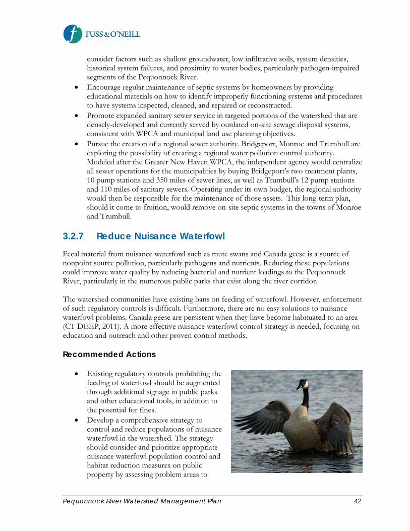
Pequonnock River Watershed Management Plan 42
consider factors such as shallow groundwater, low infiltrative soils, system densities, historical system failures, and proximity to water bodies, particularly pathogen-impaired segments of the Pequonnock River.
• Encourage regular maintenance of septic systems by homeowners by providing educational materials on how to identify improperly functioning systems and procedures to have systems inspected, cleaned, and repaired or reconstructed.
• Promote expanded sanitary sewer service in targeted portions of the watershed that are densely-developed and currently served by outdated on-site sewage disposal systems, consistent with WPCA and municipal land use planning objectives.
• Pursue the creation of a regional sewer authority. Bridgeport, Monroe and Trumbull are exploring the possibility of creating a regional water pollution control authority. Modeled after the Greater New Haven WPCA, the independent agency would centralize all sewer operations for the municipalities by buying Bridgeport's two treatment plants, 10 pump stations and 350 miles of sewer lines, as well as Trumbull's 12 pump stations and 110 miles of sanitary sewers. Operating under its own budget, the regional authority would then be responsible for the maintenance of those assets. This long-term plan, should it come to fruition, would remove on-site septic systems in the towns of Monroe and Trumbull.
3.2.7 Reduce Nuisance Waterfowl
Fecal material from nuisance waterfowl such as mute swans and Canada geese is a source of nonpoint source pollution, particularly pathogens and nutrients. Reducing these populations could improve water quality by reducing bacterial and nutrient loadings to the Pequonnock River, particularly in the numerous public parks that exist along the river corridor. The watershed communities have existing bans on feeding of waterfowl. However, enforcement of such regulatory controls is difficult. Furthermore, there are no easy solutions to nuisance waterfowl problems. Canada geese are persistent when they have become habituated to an area (CT DEEP, 2011). A more effective nuisance waterfowl control strategy is needed, focusing on education and outreach and other proven control methods. Recommended Actions
• Existing regulatory controls prohibiting the feeding of waterfowl should be augmented through additional signage in public parks and other educational tools, in addition to the potential for fines.
• Develop a comprehensive strategy to control and reduce populations of nuisance waterfowl in the watershed. The strategy should consider and prioritize appropriate nuisance waterfowl population control and habitat reduction measures on public property by assessing problem areas to
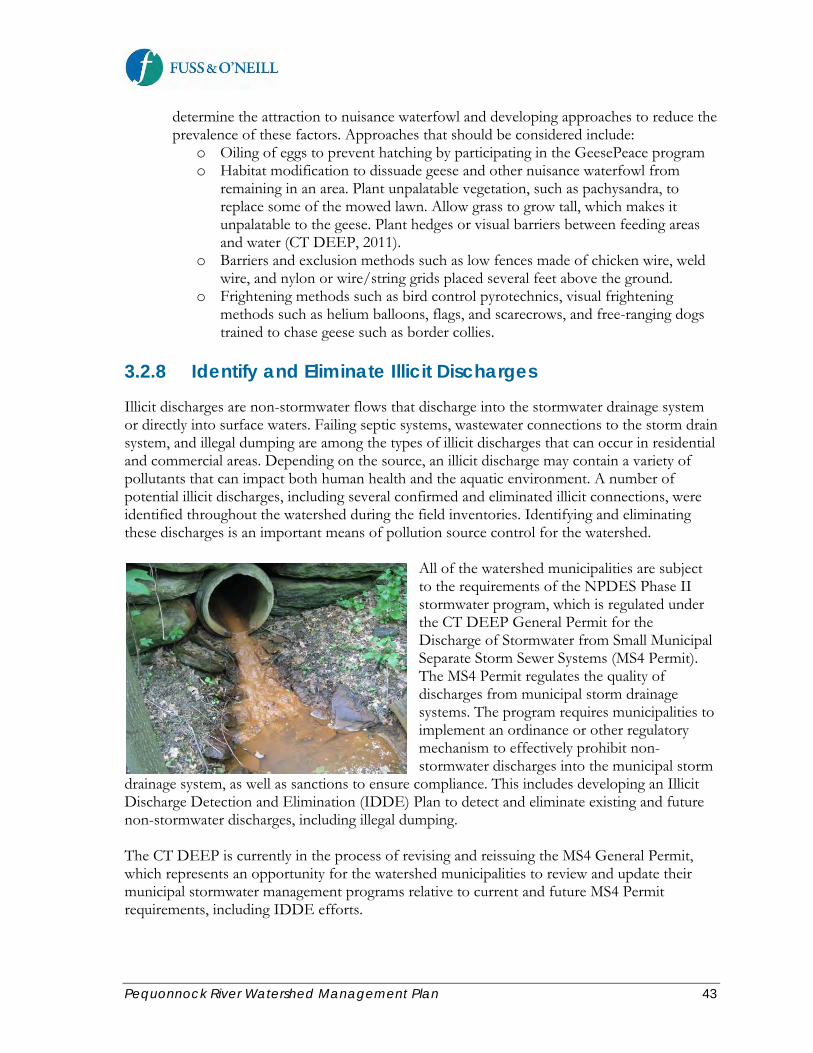
Pequonnock River Watershed Management Plan 43
determine the attraction to nuisance waterfowl and developing approaches to reduce the prevalence of these factors. Approaches that should be considered include:
o Oiling of eggs to prevent hatching by participating in the GeesePeace program o Habitat modification to dissuade geese and other nuisance waterfowl from
remaining in an area. Plant unpalatable vegetation, such as pachysandra, to replace some of the mowed lawn. Allow grass to grow tall, which makes it unpalatable to the geese. Plant hedges or visual barriers between feeding areas and water (CT DEEP, 2011).
o Barriers and exclusion methods such as low fences made of chicken wire, weld wire, and nylon or wire/string grids placed several feet above the ground.
o Frightening methods such as bird control pyrotechnics, visual frightening methods such as helium balloons, flags, and scarecrows, and free-ranging dogs trained to chase geese such as border collies.
3.2.8 Identify and Eliminate Illicit Discharges
Illicit discharges are non-stormwater flows that discharge into the stormwater drainage system or directly into surface waters. Failing septic systems, wastewater connections to the storm drain system, and illegal dumping are among the types of illicit discharges that can occur in residential and commercial areas. Depending on the source, an illicit discharge may contain a variety of pollutants that can impact both human health and the aquatic environment. A number of potential illicit discharges, including several confirmed and eliminated illicit connections, were identified throughout the watershed during the field inventories. Identifying and eliminating these discharges is an important means of pollution source control for the watershed.
All of the watershed municipalities are subject to the requirements of the NPDES Phase II stormwater program, which is regulated under the CT DEEP General Permit for the Discharge of Stormwater from Small Municipal Separate Storm Sewer Systems (MS4 Permit). The MS4 Permit regulates the quality of discharges from municipal storm drainage systems. The program requires municipalities to implement an ordinance or other regulatory mechanism to effectively prohibit non-stormwater discharges into the municipal storm
drainage system, as well as sanctions to ensure compliance. This includes developing an Illicit Discharge Detection and Elimination (IDDE) Plan to detect and eliminate existing and future non-stormwater discharges, including illegal dumping.
The CT DEEP is currently in the process of revising and reissuing the MS4 General Permit, which represents an opportunity for the watershed municipalities to review and update their municipal stormwater management programs relative to current and future MS4 Permit requirements, including IDDE efforts.

Pequonnock River Watershed Management Plan 44
Recommended Actions The following recommendations apply to each of the watershed municipalities:
• Review and update municipal stormwater management plans to ensure that IDDE efforts of the watershed municipalities (required by the MS4 Permit) include their respective areas of the Pequonnock River watershed.
• Review and update municipal stormwater management plans to ensure that the watershed municipalities implement IDDE programs as required by the existing and future MS4 Permit, including an ordinance or other regulatory mechanism to effectively prohibit non-stormwater discharges into the regulated municipal separate storm sewer system and an IDDE Plan to detect and eliminate existing and future non-stormwater discharges, including illegal dumping.
• Implement priority stream cleanup projects identified during the watershed field inventories.
• Educate municipal staff and the public on the topic of illicit discharges. • Conduct follow-up illicit discharge investigations at priority outfall locations identified
during the watershed inventories. Methods for identifying illicit discharges can vary widely in the level of effort and cost required for implementation. The following field-based methods are typically used to identify illicit discharges:
o Testing of Dry Weather Discharges – Flows from stormwater outfalls during dry weather may indicate an illicit discharge. A combination of visual inspection and chemical analysis of dry weather discharges can aid in identifying potential discharge sources.
o Visual Inspection – Examination of piping connections by either physical examination or closed-circuit camera can be used to identify possible illicit connections.
o Review of Piping Schematics – Examination of architectural plans and plumbing details can reveal potential sites of improper connections.
o Smoke Testing – Injection of a non-toxic vapor (smoke) into the facility plumbing system and following its path of travel can be used to locate connections.
o Dye Testing – In this method, appropriate colored dyes are added into the drain water of suspect piping. Appearance of the dyed water in the storm drainage system indicates an illicit discharge. As mentioned in the discussion of septic system discharges, testing for optical brighteners can provide an indication of the presence of domestic wastewater flows.
o Infrared, Aerial, and Thermal Photography – Use of aerial, infrared, and thermal photography to locate patterns of stream temperature, land surface moisture, and vegetative growth are emerging techniques to identify potential illicit discharges to stormwater systems.

Pequonnock River Watershed Management Plan 45
Other sources of information on performing illicit discharge investigations include:
• Illicit Discharge Detection and Elimination Manual - A Handbook for Municipalities, New England Interstate Water Pollution Control Commission (2003) http://www.neiwpcc.org/neiwpcc_docs/iddmanual.pdf
• Illicit Discharge Detection and Elimination - A Guidance Manual for Program Development and Technical Assessments, Center for Watershed Protection (2004)
3.2.9 Reduce Impacts from Hotspot Land Uses
Hotspot land uses are land uses with higher potential pollutant loads due to the nature of the activities and pollutant sources associated with these land uses. Hotspot land uses within the Pequonnock River watershed include commercial land use, existing and former industrial sites, municipal public works facilities, gas stations and automotive repair facilities, and high-use parking lots. An objective of this watershed management plan is to reduce the threat to water quality from land uses with higher potential pollutant loads through good housekeeping and pollution prevention, improved compliance at regulated facilities, and cleanup and sustainable re-use of contaminated (i.e., brownfield) sites. Related education and outreach recommendations are addressed in Section 3.5 of this plan. Recommended Actions
• With the future re-issuance of the CT DEEP MS4 Permit, the watershed municipalities have an opportunity to re-evaluate and improve upon the effectiveness of their municipal stormwater management programs. The watershed municipalities should review the current compliance of their respective facilities (public works/maintenance facilities, parks, schools, public safety facilities, etc.) in the watershed with pollution prevention BMPs and applicable regulatory requirements. “Good housekeeping” at municipal facilities should serve as demonstration sites for comparable private operations, many of which are also subject to stormwater pollution prevention and other similar state and federal regulatory programs (oil pollution prevention, hazardous waste, air emissions). Examples of good practices should be recognized and modeled. The Pequonnock River Initiative should provide guidance (e.g., visits, group training, and/or printed materials) and develop incentives to encourage local businesses to adopt these model practices.
• Limit the use of fertilizers and pesticides at parks and other large intensively managed
lawn areas within the watershed by promoting integrated pest management (IPM), the use of stormwater BMPs, and wetland and riparian buffer restoration and protection.
Pequonnock River Watershed Management Plan 46
Limiting fertilizer and pesticide use is most critical in areas within several hundred feet of a stream, pond, wetland, or the harbor.
• A number of industrial and commercial facilities in the watershed have permitted water
and/or stormwater discharges that are regulated by the CT DEEP. Although the CT DEEP routinely evaluates facility compliance with discharge permit requirements, the permits and associated facility compliance should be reviewed during permit reissuance. Discharge permits should contain provisions for TMDL implementation, runoff volume reduction using LID or green infrastructure approaches, and water quality protection.
• There are many former industrial sites in the lower portion of the watershed with legacy
environmental contamination. Re-use or re-development of these sites presents an opportunity to cleanup historic contamination, which poses a long-term threat to the Pequonnock River and Bridgeport Harbor, and to implement LID and green infrastructure stormwater management approaches to further reduce potential water quality and overall environmental impacts of these sites. Redevelopment of several former industrial parcels along Knowlton Street in Bridgeport into a waterfront park is an example of the type of sustainable re-use that should be considered for other contaminated or former industrial sites in the watershed.
• Identify and map the locations of Underground Storage Tanks (USTs) in the watershed
and consider prohibition of new USTs within the watershed or river corridor.
3.3 Habitat Protection and Restoration
Goal Statement: Protect and improve terrestrial, riparian, and aquatic habitat in the watershed to maintain and increase the watershed’s diversity of plant and animal species. As described in the baseline assessment report, the Pequonnock River and its watershed and Bridgeport Harbor provide abundant and significant habitat that supports a variety of fish and wildlife. Various estuarine, riverine, and upland areas provide habitat to finfish, shellfish, mammals, amphibians, reptiles and birds. Notable tracts of protected or preserved parkland in the watershed, and in particular along the river corridor, provide valuable habitat or unique natural resources in an otherwise developed suburban and urban watershed. The following objectives and recommended actions will serve to protect and restore the various habitats that exist within the watershed. 3.3.1 Protect and Restore Aquatic and Stream Corridor Habitat
The Pequonnock River and several of its tributaries are an important urban coastal fishery for certain anadromous (migrating upriver to spawn during spring) and resident fish species, including brook, brown, and rainbow trout (mix of native and stocked), largemouth and rock bass (non-native), bluegill and redbreast sunfish (mix of native and stocked), American eel

Pequonnock River Watershed Management Plan 47
(native), and yellow perch (native). River herring and blueback herring, both anadromous fish species, are present in the lower Pequonnock River and have been the focus of cooperative management and restoration efforts. Stream continuity for fish passage has been severely compromised in many areas of the watershed, preventing fish passage to the middle and upper reaches of the watershed. The first obstruction encountered in the Lower Pequonnock River is the concrete-lined channel that has very shallow flow during low-flow periods, located just downstream of Bunnell’s Pond. The Pequonnock River Apron Fishway project will create a fish ladder in the existing concrete apron to restore safe passage of river herring and other resident fish species to the Bunnell’s Pond fishway and upstream reaches within the watershed.
Thousands of blueback and river herring are estimated to use the Bunnell’s Pond fishway each year. Pending the availability of future funding, the CT DEEP plans to install a camera at the fishway to count and identify fish and educate the general public. Bunnel’s Pond dam also has an eel pass. Eels are captured in a holding tank and are then transported upstream by CT DEEP staff to the pond. CT DEEP is working to modify the eel pass configuration to improve eel passage at this location.
Many of the upper portions of the Pequonnock River and its tributaries have long reaches of unobstructed stream. However, in other areas of the upper watershed, obstructions such as road crossings, dams, and long culvertized reaches exist along the river that limit or prevent passage of fish and other aquatic organisms. These obstructions could be modified to improve passage of eel and resident fish species. Additionally, several of the dams no longer serve a purpose, and removal could benefit in-stream habitat and fish passage. A key objective of this plan is to protect and restore naturally reproducing fish populations in the watershed by removing barriers to fish passage as well as restoring or enhancing in-stream and riparian habitat. Recommended Actions
• Construct the Pequonnock River Apron Fishway project. • Install a camera at the Bunnell’s Pond fishway to count and identify fish and to educate
the public. • Modify the Bunnell’s Pond dam eel pass configuration to improve eel passage. • Some existing or potential barriers to fish passage were identified during the field
inventories. A more comprehensive fish passage evaluation is recommended in the upper portions of the watershed to refine the understanding of fish passage barriers and opportunities for restoring fish passage and aquatic habitat along the majority of the river system. The evaluation should consider overall site-specific feasibility (land

Pequonnock River Watershed Management Plan 48
ownership, upstream and downstream conditions, infrastructure constraints, construction access, etc.) and ecological benefits, and should include geomorphic assessments to identify specific stream reaches in need of habitat restoration.
• Revise local storm drainage design standards and regulations such that new or modified stream crossings are designed following the Connecticut Stream Crossing Guidelines.
• Implement priority stream restoration projects. A significant amount of stream channel modification has occurred throughout the watershed. Segments of some streams in the watershed are buried in underground conduits, resulting from historical development and past storm drainage practices and flood control practices. Areas of moderate to severe streambank erosion also exist in many areas of the watershed. Several of these reaches offer good opportunities for stream restoration projects. Table 3-4 lists stream reaches with modified stream channels and significant bank erosion that were identified during the watershed field inventories. These reaches are potential stream restoration candidates, and their locations are shown on the subwatershed mapping in Appendix C. Typical stream restoration techniques that could be implemented in the watershed include:
o Slope stabilization techniques o Redirective or flow changing techniques o Toe protection techniques o Bioengineering techniques o Grade control techniques o Riparian buffer improvement
Several proposed stream restoration concepts are also presented in Section 4 of this plan.
Access to many of the potential stream restoration sites is limited; therefore, potential candidate sites should be evaluated further for overall feasibility including land ownership, erosion severity, upstream and downstream conditions, infrastructure constraints, and construction access to the stream. In general, stream restoration and other habitat improvement projects should be implemented by identifying “seed” funding for the initial design phases, followed by the development of subwatershed plans with more detailed designs, which will increase the chances of state and federal funding for these projects.
Table 3-4. Potential Stream Restoration Opportunities
Map ID
Location/ Stream
Reach ID Site ID Description
S-1 LPR-04 CM-01 The stream channel has been modified and has stone bank armoring.
S-2 LPR-05/06 CM-01 The entire stream segment is a concrete channel
S-3 LPR-07 CM-01 This segment is entirely concrete and has a concrete apron to control grade and stabilize the stream bed prior to entering the underground culvert.
S-4 LPR-07 CM-02 Low flow channel inlet to fish ladder at Bunnell's Pond Dam.
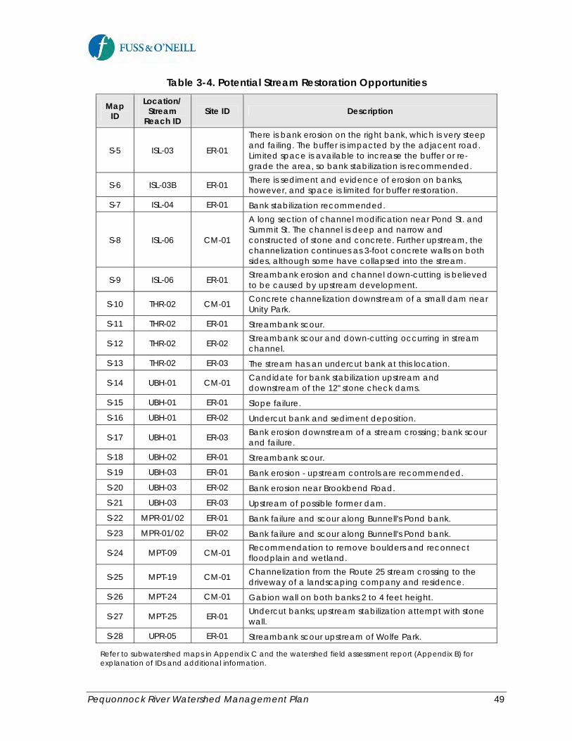
Pequonnock River Watershed Management Plan 49
Table 3-4. Potential Stream Restoration Opportunities
Map ID
Location/ Stream
Reach ID Site ID Description
S-5 ISL-03 ER-01
There is bank erosion on the right bank, which is very steep and failing. The buffer is impacted by the adjacent road. Limited space is available to increase the buffer or re-grade the area, so bank stabilization is recommended.
S-6 ISL-03B ER-01 There is sediment and evidence of erosion on banks, however, and space is limited for buffer restoration.
S-7 ISL-04 ER-01 Bank stabilization recommended.
S-8 ISL-06 CM-01
A long section of channel modification near Pond St. and Summit St. The channel is deep and narrow and constructed of stone and concrete. Further upstream, the channelization continues as 3-foot concrete walls on both sides, although some have collapsed into the stream.
S-9 ISL-06 ER-01 Streambank erosion and channel down-cutting is believed to be caused by upstream development.
S-10 THR-02 CM-01 Concrete channelization downstream of a small dam near Unity Park.
S-11 THR-02 ER-01 Streambank scour.
S-12 THR-02 ER-02 Streambank scour and down-cutting occurring in stream channel.
S-13 THR-02 ER-03 The stream has an undercut bank at this location.
S-14 UBH-01 CM-01 Candidate for bank stabilization upstream and downstream of the 12" stone check dams.
S-15 UBH-01 ER-01 Slope failure.
S-16 UBH-01 ER-02 Undercut bank and sediment deposition.
S-17 UBH-01 ER-03 Bank erosion downstream of a stream crossing; bank scour and failure.
S-18 UBH-02 ER-01 Streambank scour.
S-19 UBH-03 ER-01 Bank erosion - upstream controls are recommended.
S-20 UBH-03 ER-02 Bank erosion near Brookbend Road.
S-21 UBH-03 ER-03 Upstream of possible former dam.
S-22 MPR-01/02 ER-01 Bank failure and scour along Bunnell's Pond bank.
S-23 MPR-01/02 ER-02 Bank failure and scour along Bunnell's Pond bank.
S-24 MPT-09 CM-01 Recommendation to remove boulders and reconnect floodplain and wetland.
S-25 MPT-19 CM-01 Channelization from the Route 25 stream crossing to the driveway of a landscaping company and residence.
S-26 MPT-24 CM-01 Gabion wall on both banks 2 to 4 feet height.
S-27 MPT-25 ER-01 Undercut banks; upstream stabilization attempt with stone wall.
S-28 UPR-05 ER-01 Streambank scour upstream of Wolfe Park.
Refer to subwatershed maps in Appendix C and the watershed field assessment report (Appendix B) for explanation of IDs and additional information.

Pequonnock River Watershed Management Plan 50
3.3.2 Protect and Restore Forests and Watershed Tree Canopy
Forest cover provides numerous benefits at both the site and watershed scales. In addition to providing habitat for terrestrial and aquatic wildlife, watershed forest cover also reduces storm water runoff and flooding, improves regional air quality, reduces stream and channel erosion, improves soil and water quality, and reduces summer air and water temperatures (USDA Forest Service, 2005). Traditional approaches to restoring urban watersheds that have relied on structural solutions have failed to protect and restore urban streams. Through green infrastructure approaches, vegetation and natural systems are now considered a key tool in the protection and restoration of urban watersheds.
Approximately 36% of the Pequonnock River watershed consists of deciduous and coniferous forest cover. The percent forest cover in each subwatershed ranges from a low of approximately 1% in the Lower Pequonnock River subwatershed to a high of approximately 58% in the Upper West Branch Pequonnock River subwatershed. While significant, healthy forest cover exists in many areas of the upper watershed, additional forest cover and tree canopy could provide substantial benefits in the lower, urban areas of the watershed. Recent and
ongoing development activities in the watershed continue to threaten forest cover and contribute to fragmentation of existing forest cover in the watershed. The following actions are recommended to protect and enhance forested areas and tree canopy within the watershed. Recommended Actions Watershed-wide (Monroe, Trumbull, and Bridgeport)
• Protect existing forests through land acquisition and conservation easements. • Amend site development regulations and zoning to encourage tree retention and
maintenance, restrict tree removal, and require landscaping and parking lot shading. • Reforest public lands, beginning with priority sites. • Encourage large trees wherever possible. • Encourage reforestation of private land by developing education, stewardship and
incentive programs. For larger parcels, contact a state forester or private consulting forester to developing specific goals and objectives for that property.
• Identify priority sites for reforestation. • Encourage native rather than non-native species and educate the public, municipalities,
and landowners about the importance and identification of native tree species. Work with the municipalities to require the use of native tree species in land development and redevelopment projects and to use native tree species in municipal projects.

Pequonnock River Watershed Management Plan 51
• Engage the tree wardens in the watershed municipalities, particularly as relates to tree health, tree retention and canopy cover goals.
• Demonstrate the importance of trees and vegetation as a critical component of green infrastructure and the related water quality benefits through local tree canopy demonstration projects.
• Consider developing a tree ordinance, especially for canopy protection along the river corridor.
Bridgeport
• Conduct a detailed Urban Tree Canopy (UTC analysis. A planning-level watershed tree canopy analysis was conducted as part of the baseline assessment report. Forest cover was estimated based on relatively coarse-resolution satellite land cover data for the watershed, which is limited in its ability to capture individual trees or stands of trees which are common in developed areas. The City of Bridgeport, in conjunction with the CT DEEP Division of Forestry and the U.S. Forest Service, has received an America the Beautiful Grant to conduct a more detailed analysis of the City’s UTC and develop an urban forest effects model. The analysis will utilize high-resolution aerial imagery, field evaluations, and GIS analysis techniques (including the i-Tree software tool) to provide detailed estimates of the extent and distribution of UTC within the City. The results of the analysis will be used to establish UTC goals and target priority areas and recommendations for additional tree protection and reforestation efforts.
• Identify areas where local regulations/ordinances pertaining to tree canopy may need to be strengthened.
• Implement local tree planting demonstration projects within the Pequonnock River watershed, including a work plan and schedule.
3.3.3 Manage Invasive Plant Species
Native vegetation plays an important role in ecosystem biodiversity. Invasive plants have displaced native species and threaten local biodiversity and ecosystem function in the watershed. Invasive plants and invasive aquatic plants have been identified in many areas of the watershed. The most common and visible plant species include Phragmites australis, purple loostrife, and Japanese knotweed. Invasive aquatic plants are also prevalent in some water bodies in the watershed. Invasive species management efforts should focus on site-specific and targeted stream corridor improvements. Recommended Actions
• Implement priority invasive species management projects identified during the watershed field inventories.
• Develop an invasive species management plan for targeted and accessible areas of the watershed or targeted subwatersheds, including prevention and education efforts to preempt arrivals, early detection and citizen monitoring efforts, rapid response measures for successful eradication, and when a species cannot be eradicated, continued control efforts that are necessary to minimize ecological and economic impacts. The plan could identify prevention and education efforts to preempt arrivals, early detection and citizen

Pequonnock River Watershed Management Plan 52
monitoring efforts, response measures for successful eradication, and when a species cannot be eradicated, continued control efforts that are necessary to minimize ecological and economic impacts. The invasive species management plan should borrow from the successes of other local or regional invasive species control programs elsewhere in Connecticut. Information on invasive plant species planning and management can be obtained from:
o U.S. Fish and Wildlife Service: (http://www.fws.gov/invasives/staffTrainingModule/planning/introduction.html),
o The Connecticut Department of Environmental Protection o The Nature Conservancy (TNC) o Connecticut Invasive Plant Working Group (CIPWG)
• Educate residents, facility maintenance personnel, landscapers and local nurseries, and land use commissions about the negative effects of non-native invasive species, pathways of introduction, and alternatives to invasive ornamental plants.
• Involve volunteers and neighborhood groups in invasive species removal and stream corridor improvements.
3.3.4 Conduct Cleanups and Discourage Illegal Dumping
Dumping of trash and debris in and adjacent to the stream is a significant problem, especially in the Island Brook subwatershed. In more urbanized areas of the watershed, widespread areas of trash and associated debris were observed within the stream corridor, whereas in more suburban settings, trash and illegal dumping appears to be more isolated such as near hotspot locations with poor visibility from roadways and buildings. Stream clean-ups and trash removal are often cosmetic and temporary. However, they are
an effective tool for involving and educating the public about stream degradation. In addition, some trash and debris accumulation may present risks to infrastructure and increased flooding, such as when outfalls and culverts become clogged with trash. Several successful stream cleanup events were performed as part of the education and outreach efforts led by the PRI during the development of this watershed plan. Recommended Actions Watershed-wide (Monroe, Trumbull, and Bridgeport)
• Continue to conduct regular stream and beach cleanup projects throughout the watershed. The cleanup events should be publicized to involve citizen volunteers. The
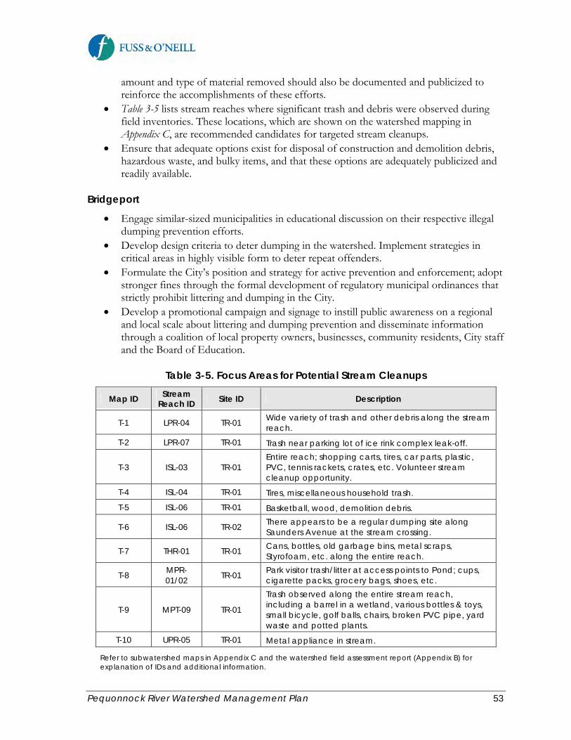
Pequonnock River Watershed Management Plan 53
amount and type of material removed should also be documented and publicized to reinforce the accomplishments of these efforts.
• Table 3-5 lists stream reaches where significant trash and debris were observed during field inventories. These locations, which are shown on the watershed mapping in Appendix C, are recommended candidates for targeted stream cleanups.
• Ensure that adequate options exist for disposal of construction and demolition debris, hazardous waste, and bulky items, and that these options are adequately publicized and readily available.
Bridgeport
• Engage similar-sized municipalities in educational discussion on their respective illegal dumping prevention efforts.
• Develop design criteria to deter dumping in the watershed. Implement strategies in critical areas in highly visible form to deter repeat offenders.
• Formulate the City’s position and strategy for active prevention and enforcement; adopt stronger fines through the formal development of regulatory municipal ordinances that strictly prohibit littering and dumping in the City.
• Develop a promotional campaign and signage to instill public awareness on a regional and local scale about littering and dumping prevention and disseminate information through a coalition of local property owners, businesses, community residents, City staff and the Board of Education.
Table 3-5. Focus Areas for Potential Stream Cleanups
Map ID Stream Reach ID Site ID Description
T-1 LPR-04 TR-01 Wide variety of trash and other debris along the stream reach.
T-2 LPR-07 TR-01 Trash near parking lot of ice rink complex leak-off.
T-3 ISL-03 TR-01 Entire reach; shopping carts, tires, car parts, plastic, PVC, tennis rackets, crates, etc. Volunteer stream cleanup opportunity.
T-4 ISL-04 TR-01 Tires, miscellaneous household trash.
T-5 ISL-06 TR-01 Basketball, wood, demolition debris.
T-6 ISL-06 TR-02 There appears to be a regular dumping site along Saunders Avenue at the stream crossing.
T-7 THR-01 TR-01 Cans, bottles, old garbage bins, metal scraps, Styrofoam, etc. along the entire reach.
T-8 MPR-01/02 TR-01 Park visitor trash/litter at access points to Pond; cups,
cigarette packs, grocery bags, shoes, etc.
T-9 MPT-09 TR-01
Trash observed along the entire stream reach, including a barrel in a wetland, various bottles & toys, small bicycle, golf balls, chairs, broken PVC pipe, yard waste and potted plants.
T-10 UPR-05 TR-01 Metal appliance in stream.
Refer to subwatershed maps in Appendix C and the watershed field assessment report (Appendix B) for explanation of IDs and additional information.

Pequonnock River Watershed Management Plan 54
3.4 Sustainable Land Use and Open Space
Goal Statement: Promote sustainable growth and appropriate development in the watershed while preserving and improving the watershed’s natural resources, providing public access to open space, and addressing current and future flooding problems. 3.4.1 Strengthen Land Use Regulations
Municipal land use plans and regulations help shape the development patterns within a watershed and can play a significant role in protecting water quality and other natural resources at the watershed scale. These commonly include municipal plans of conservation and development, zoning regulations, subdivision regulations, inland wetland and watercourses regulations, and stormwater regulations, all of which influence the type and density of development that can occur within a watershed. Local land use regulations often vary by municipality within a watershed, and regulations are periodically revised in response to development pressure, shifts in attitude toward natural resource protection, and political and socioeconomic factors. Because a watershed management plan encompasses multiple municipalities, a watershed-based regulations review also provides an opportunity for towns or cities to compare their regulatory mechanisms to those of neighboring municipalities. By doing so, they can evaluate the relative merits of different approaches, adopt the best models, and improve region-wide consistency in how the common water resource is managed. This review of land use regulations and land use plans by municipality and other entities in the Pequonnock River watershed is, therefore, a tool that can be used to achieve several objectives. The land use regulatory review that was performed as part of the plan development process identified areas for improvements in municipal local land use regulations and related land use planning documents to protect water resources throughout the watershed. The following sections summarize recommendations for the three primary municipalities in the watershed – Monroe, Trumbull, and Bridgeport. All three communities have expressed a desire for strengthened land use regulatory controls related to stormwater management, riparian buffers and riverfront development, and tree protection and preservation. Projects recently completed by a number of Farmington River watershed communities to remove barriers to and implement Low Impact Development (LID) regulations can serve as a model for implementation of similar recommendations in the Pequonnock River watershed municipalities. Recommended Actions Bridgeport The City of Bridgeport has begun to embrace sustainability in its local planning efforts and through its land use regulations. The City is implementing an ambitious city-wide sustainability initiative through its BGreen 2020 sustainability master plan. The plan includes a number of water resource-related programs including the use of green infrastructure to address combined sewer overflows and stormwater management through stormwater retrofits at vacant or

Pequonnock River Watershed Management Plan 55
underutilized parcels, water conservation as well as stormwater harvesting and reuse, integration of stormwater management and public infrastructure improvements through the City’s “complete streets” program, and an urban forestry initiative. The City of Bridgeport is also developing a comprehensive parks master plan and has begun waterfront revitalization efforts along the Lower Pequonnock River by redeveloping vacant or underutilized former industrial sites for passive recreation and other mixed-uses. Consistent with these initiatives, the City recently revised its zoning, subdivision and inland wetlands regulations in 2010 and its comprehensive master plan of conservation and development in 2008. The City’s Engineering Department and Water Pollution Control Authority also developed a stormwater management manual in 2008, which outlines design standards and stormwater management criteria for projects that are subject to the local land use review and approval process. As indicated above, the City completed its BGreen 2020 sustainability plan in 2010. Recommendations for additional improvements to Bridgeport’s land use regulations and planning documents to further the goals of this watershed management plan include: River Corridor and Wetlands
• Maintain comprehensive on-line mapping of critical water resources including, but not limited to, watercourses, wetlands, and flood hazard zones.
• Promote preservation and restoration of wetlands and watercourses in City plans and policies.
• Adopt local riparian buffer regulations, with the goal of establishing a contiguous vegetated riparian area on either side of the Pequonnock River and its tributaries (rivers and perennial streams). Recommended elements of a riparian buffer regulation include:
o Establish regulated riparian zones, which may vary in width depending on the resource type (stream, pond, or wetlands) and nature of the land use. Larger buffer widths could be required for land uses with the potential to contribute significant pathogen and other pollutant loads to receiving waters such as hot spot land uses. Refer to the CT DEEP’s Upland Review Area Guide.
o Establish maximum disturbance and include vegetation replacement and mitigation for various activities.
o Limit the area of vegetation that can be disturbed for various regulated activities. A permit for activity involving disturbance of the riparian zone would be issued only if specific conditions are met, such as:
The basic purpose of the project cannot be accomplished on site without disturbing vegetation in the riparian zone.
Disturbance to the riparian zone is eliminated where possible and minimized where not possible by relocating the project, reducing the size of the project, or situating the project in portions of the riparian zone where previous development or disturbance has occurred.
Any temporarily cleared area of vegetation must be replanted with indigenous, non-invasive vegetation.
Limits on the amount of disturbance allowed for specific activities. o Limit disturbance within specified distances from the top of bank for certain
activities.

Pequonnock River Watershed Management Plan 56
o Where the standards cannot be met, providing greater than 1:1 compensation in the form of re-vegetation and placing a deed restriction on the compensation area.
• Include standards for stream crossings which provide for consistency with Connecticut Department of Environmental Protection’s Stream Crossing Guidelines.
• Develop and implement appropriate waterfront zoning regulations through the Office of Planning and Economic Development that conform to the goals and objectives of this watershed management plans and the City’s other land use planning documents. The regulations should address public access to the waterfront and other land use issues, while promoting resource protection.
• Establish a formal process to streamline review and enforcement of non-compliance and poor practices that are identified through field inventories and assessments.
Stormwater Management
• Consider incentives to promote the use of LID for private development such as increased development densities, reduced review time or expedited review, reduced application fees, and reduced property taxes.
• Consider relatively minor changes to the City’s existing stormwater manual requirements, including:
o Reference the LID addendum to the CT DEEP Stormwater Quality Manual, which is expected to be issued later in 2011. The addendum is expected to contain updated LID and green infrastructure standards and design guidance.
o The City’s existing stormwater manual allows an exemption from flow control (peak rate of runoff and runoff volume) for certain projects that discharge stormwater runoff directly into the Yellow Mill River, Pequonnock River, or Long Island Sound and have a surface area less than 5% of the watershed area upstream of the developed site. Pollution reduction requirements still apply to these projects. However, because pollutant loads are affected both by runoff pollutant concentrations and runoff volume, the City should consider revising the exemption such that runoff volume reduction is required for projects that discharge stormwater runoff directly into the Yellow Mill River, Pequonnock River, or Long Island Sound. This would also better promote more consistent use of infiltration-based LID and green infrastructure techniques for projects within the Pequonnock River corridor.
• Consider the development of a stormwater utility district (or fee similar to that discussed in the plan of conservation and development) at the municipal level or through a regional effort such as a regional water pollution control authority for the watershed municipalities, modeled after the Greater New Haven WPCA, as is currently being considered (note: regional stormwater districts may also require changes in state legislation). The feasibility of a stormwater utility should be informed by lessons learned from the recent CT DEEP stormwater utility pilot projects, the ongoing work by the CT DEEP to incorporate LID into state permits and policy, the ongoing “green scan” project led by Save the Sound and Connecticut Fund for the Environment in Bridgeport and New Haven, and ongoing efforts by the City of New Haven to establish a stormwater utility.

Pequonnock River Watershed Management Plan 57
• Review the municipal code and regulations for potential regulatory barriers to implementing downspout disconnection and revise the ordinances/regulations accordingly.
• Revise the City’s Phase II Stormwater Management Plan for consistency with the MS4 Permit, when reissued.
• In addition to the strategies discussed in the plan of conservation and development and BGreen 2020:
o Review current setbacks and lot dimensions in subdivisions for potential to relax side yard setbacks and allow narrower frontages to reduce road length and site imperviousness, and to relax front setback requirements to reduce driveway length and lot imperviousness.
o Review existing parking ratios to see if lower ratios are warranted and feasible. The required parking ratio for a particular land use (other than commercial retail) should be enforced as both a maximum and minimum to limit excess parking space construction and impervious cover.
o Consider allowing the Commission to approve parking lots with more spaces than the allowed maximum provided all of the spaces above the maximum number are composed of a pervious surface, and where adequate stormwater management is provided.
o Consider parking spaces held in reserve for phased developments, thereby avoiding the situation where unnecessary parking is not constructed if future phases of development do not occur.
o Modify the parking area landscaped area requirements in the zoning regulations to promote parking lot bioretention and other LID practices.
• As discussed in the plan of conservation and development and BGreen 2020: o Encourage infill development and development of brownfield sites
(contaminated sites) and greyfield sites (underutilized or abandoned sites) through such tools as density bonuses, tax incentives, and streamlined permitting.
o Consider allowing offsite treatment of stormwater and wastewater at brownfield and greyfield sites to reduce overall development costs.
Tree Protection
• Strengthen the landscape provisions of the zoning and subdivision regulations by requiring maximum tree preservation, replacement and diversity of tree species; requiring that public trees damaged during construction are removed and replaced; and adopting tree protection rules for public trees during construction projects.
• Alternatively, adopt a stand-alone tree ordinance, informed by the results of the City’s upcoming urban tree canopy study. The City of Hartford recently adopted a similar tree ordinance that could be used as a model. New York City also has an ambitious tree planting and preservation program (“Million Trees” initiative http://www.milliontreesnyc.org/html/home/home.shtml, elements of which could be adapted for the City of Bridgeport.

Pequonnock River Watershed Management Plan 58
Other Issues • Adopt this watershed management plan in the City’s Plan of Conservation and
Development and BGreen Sustainability Plan. • Integrate the goals, objectives, and recommendations of this watershed management
plan into the City’s ongoing comprehensive parks master planning efforts. Consider establishing an administrative process or public funding to support open space planning and acquisition.
• Consider establishing an advisory Conservation Commission to focus on open space planning, park expansion, community gardens, urban forestry, green spaces master plan and linkages.
• Consider amending the zoning regulations to prohibit or restrict new USTs within the Pequonnock River watershed or river corridor.
• Adopt regulations or make specific recommendations concerning the use of pesticides such as discussed in the Plan of Conservation and Development.
Monroe The Town of Monroe recently revised its inland wetlands regulations in August 2010 for consistency with the CT DEEP model regulations. The Town also amended its zoning regulations in June 2010. The amendments primarily addressed flood damage prevention requirements. Monroe’s zoning and subdivision regulations are somewhat dated with respect to stormwater management, Low Impact Development, riparian buffers, and tree protection, with many section of the regulations having been developed or last revised in the 1980s and 1990s. The Town revised its Plan of Conservation and Development in December 2010, which recommends significant changes to the Town’s land use regulations to achieve resource protection, open space, and sustainability objectives. Specific land use regulatory and planning recommendations for Monroe to further the goals of this watershed management plan include: River Corridor and Wetlands
• Consistent with Chapter 8 of Monroe’s Plan of Conservation and Development, adopt local riparian buffer regulations, with the goal of establishing a contiguous vegetated riparian area on either side of the Pequonnock River and its tributaries (rivers and perennial streams). Recommended elements of a riparian buffer regulation are described in similar recommendations for Bridgeport.
• Include standards for stream crossings which provide for consistency with Connecticut Department of Environmental Protection’s Stream Crossing Guidelines.
• Retain and maintain a maximum amount of natural vegetation on slopes over 15%, particularly those within the Upland Review Area of a watercourse or wetland. Prevent clear-cutting or tree removal beyond the established limits of disturbance.
• Establish no-build setback areas from wetlands and watercourses for new development of structures, pools, septic systems, etc.
• Consider the following additions to the zoning and/or subdivision regulations to help prevent potential pollution of the town’s wetlands, watercourses, and groundwater:
o Maintain minimum distance between manure piles and wetlands/watercourses (manure management), as well as natural barriers, such as earthen berms.

Pequonnock River Watershed Management Plan 59
o Maintain undisturbed buffer zones between wetlands/watercourses and agricultural uses, increasing buffer size for uses requiring fertilizer, pesticides and other pollutants.
Stormwater Management
• Revise the zoning, subdivision, and inland wetlands regulations to strengthen stormwater management requirements and require the use of LID site planning and design approaches. Consider developing local LID design guidance and standards or reference the forthcoming LID addendum to the CT DEEP Stormwater Quality Manual. The regulations could then reference the local design guidance or state guidance.
• Consider adopting a stormwater runoff volume control standard in addition to peak flow rate control for most new development and redevelopment projects (i.e., zero net increase in runoff volume and peak flow rate).
• Create standards for retrofitting existing commercial properties for stormwater management adjacent to the wetlands and other environmentally sensitive areas, especially for properties along Routes 25 and 111.
• Consider incentives to promote the use of LID for private development such as increased development densities, reduced review time or expedited review, reduced application fees, and reduced property taxes.
• Consider the development of a stormwater utility district at the municipal level or through a regional effort such as a regional water pollution control authority for the watershed municipalities. See similar recommendation for Bridgeport.
• Revise the City’s Phase II Stormwater Management Plan for consistency with the MS4 Permit, when reissued.
• Incorporate LID site planning and design principles and stormwater management systems into redevelopment plans for vacant parcels along the Route 25 and 111 corridors in the watershed, as recommended in the latest Plan of Conservation and Development. Address drainage needs along Routes 25 and 111 by coordinating improvements with proposed CTDOT plans.
• Review the zoning and subdivision regulations for potential opportunities to reduce impervious cover in new development and redevelopment projects:
o Review current setbacks and lot dimensions in subdivisions for potential to relax side yard setbacks and allow narrower frontages to reduce road length and site imperviousness, and to relax front setback requirements to reduce driveway length and lot imperviousness.
o Review existing parking ratios to see if lower ratios are warranted and feasible. The required parking ratio for a particular land use (other than commercial retail) should be enforced as both a maximum and minimum to limit excess parking space construction and impervious cover.
o Consider allowing the Commission to approve parking lots with more spaces than the allowed maximum provided all of the spaces above the maximum number are composed of a pervious surface, and where adequate stormwater management is provided.

Pequonnock River Watershed Management Plan 60
o Consider parking spaces held in reserve for phased developments, thereby avoiding the situation where unnecessary parking is not constructed if future phases of development do not occur.
o Modify the parking area landscaped area requirements in the zoning regulations to promote parking lot bioretention and other LID practices.
o Establish requirements for maximum lot coverage for all new development and redevelopment.
o Review Town road standards to reduce the amount of impervious surfaces by reducing road widths whenever appropriate and promote LID approaches in roadway design (i.e., green/complete streets).
• Update Town stormwater drainage maps for use by the Town Departments. • Develop an illicit discharge ordinance that prohibits improper water discharges to the
Town’s regulated municipal storm drainage system (MS4), which is a requirement of the CT DEEP MS4 Permit.
• Encourage the use of pervious paving materials to the maximum extent practicable and minimize impervious surfaces in recreation and open space areas.
• Within subdivisions, design open areas to serve as filters, buffers, swales, wet and dry ponds, and detention and retention areas.
• Within public open areas such as parks and playgrounds, design for filtering polluted runoff from adjacent impervious areas.
Tree Protection
• Consider adopting a tree preservation, protection, and clearance ordinance, especially for canopy protection along the river corridor. See recommendation for Bridgeport.
• The Monroe Zoning Enforcement Officer (acting as a tree warden) should review and approve tree plantings in any new development application that comes before the Planning and Zoning Commission for consistency and adherence to a local tree ordinance, and to prevent invasive/non-native plantings.
Groundwater and Drinking Water Supply Protection
• Review current regulations for groundwater and surface water protection and encourage measures to enhance local recharge, including dry wells, downspout disconnection, rain gardens, and permeable pavement.
• Consistent with recommendations of the Plan of Conservation and Development, evaluate and map the Town’s aquifers for potential inclusion in the State’s Aquifer Protection Area Program.
• Strengthen drinking water quality protection in areas of high groundwater availability and water supply watersheds.
• Consider amending the zoning regulations to prohibit or restrict new USTs within the Pequonnock River watershed or river corridor.
Open Space
• Consider the water quality and natural resource benefits of open space development in the open space study recommended by the Plan of Conservation and Development.
• Adopt open space provisions in the subdivision regulations. Consider increasing minimum open space requirements for new residential subdivisions, including a

Pequonnock River Watershed Management Plan 61
suggested minimum of 20% open space in all subdivisions and 30% in cluster subdivisions. Wetlands and steep slopes greater than 20% should not be counted toward the total open space percentage.
• Consider requiring conservation easements to be placed on Upland Review Areas of new subdivisions.
• Establish reduced lot size (“cluster”) subdivision regulations to preserve open space on development sites.
• Offer incentives to developers to protect open space and environmentally sensitive areas. Consider density or building height bonuses, tax incentives, streamlined permitting, and Transfer of Development Rights (TDR) to protect natural resources and encourage infill development in densely developed areas with appropriate existing infrastructure.
Other Issues
• Adopt this watershed management plan in the Town’s Plan of Conservation and Development.
• Consider developing a steep slope ordinance and hillside protection ordinance. • Implement the recommendations of the Town’s Water Pollution Control Plan and
Sewer Service Area Map, including sewer infrastructure needs along the Route 25 and 11 corridors. Continue to explore possible formation of a regional WPCA with the other watershed communities.
Trumbull The Town of Trumbull revised its inland wetlands regulations in 2010 for consistency with the CT DEEP model regulations. Trumbull also revised its zoning regulations in 2008 and again in 2010. The Town’s subdivision regulations were last amended in 2000, and the Trumbull Plan of Conservation and Development was last revised in 2006. Trumbull also developed an administrative stormwater policy in 2007, which was subsequently revised in 2009. The policy outlines stormwater management and drainage design standards and is consistent with the stormwater management requirements in the Town zoning regulations. While the zoning regulations and stormwater policy address stormwater quality and quantity requirements, both could be revised to require or better promote the use of LID approaches and practices. Specific land use regulatory and planning recommendations for Monroe to further the goals of this watershed management plan include: River Corridor and Wetlands
• Work with the Trumbull Inland Wetlands and Watercourses Commission to adopt local riparian buffer regulations, including application process, management practices, and enforcement mechanisms. Recommended elements of a riparian buffer regulation are described in similar recommendations for Monroe and Bridgeport.
• Include standards for stream crossings which provide for consistency with Connecticut Department of Environmental Protection’s Stream Crossing Guidelines.
• Retain and maintain a maximum amount of natural vegetation on slopes over 15%, particularly those within the Upland Review Area of a watercourse or wetland. Prevent clear-cutting or tree removal beyond the established limits of disturbance.

Pequonnock River Watershed Management Plan 62
• Establish no-build setback areas from wetlands and watercourses for new development of structures, pools, septic systems, etc.
Stormwater Management
• Revise the zoning, subdivision, inland wetlands regulations, and the Town’s stormwater management and drainage design standards to place greater emphasis on the use of Low Impact Development. Consider incorporating elements of the forthcoming LID addendum to the CT DEEP Stormwater Quality Manual.
o Clarify the “Zero Incremental Runoff” requirement in the existing zoning regulations and stormwater management and drainage design standards to include peak runoff rate, runoff volume, or both. A stormwater runoff volume control standard in addition to peak flow rate control for most new development and redevelopment projects.
o Include a recommended process for incorporating LID site planning and design approaches.
o Include a list of recommended LID stormwater practices such as bioretention, water quality swales, pervious pavement, downspout disconnection, amended soils, rain barrels and rain gardens, etc. and associated design guidance.
o Create standards for retrofitting existing commercial properties for stormwater management adjacent to the wetlands and other environmentally sensitive areas, especially for properties along Routes 25 and 111.
• Consider incentives to promote the use of LID for private development such as increased development densities, reduced review time or expedited review, reduced application fees, and reduced property taxes.
• Consider the development of a stormwater utility district at the municipal level or through a regional effort such as a regional water pollution control authority for the watershed municipalities. See similar recommendations for Monroe and Bridgeport.
• Revise the City’s Phase II Stormwater Management Plan for consistency with the MS4 Permit, when reissued.
• Review the zoning and subdivision regulations (particularly the older subdivision regulations) for potential opportunities to reduce impervious cover in new development and redevelopment projects.
o Review current setbacks and lot dimensions in subdivisions for potential to relax side yard setbacks and allow narrower frontages to reduce road length and site imperviousness, and to relax front setback requirements to reduce driveway length and lot imperviousness.
o Review existing parking ratios to see if lower ratios are warranted and feasible. The required parking ratio for a particular land use (other than commercial retail) should be enforced as both a maximum and minimum to limit excess parking space construction and impervious cover.
o Consider allowing the Commission to approve parking lots with more spaces than the allowed maximum provided all of the spaces above the maximum number are composed of a pervious surface, and where adequate stormwater management is provided.
o Modify the parking area landscaped area requirements in the zoning regulations to specifically promote parking lot bioretention and other LID practices.
Pequonnock River Watershed Management Plan 63
o Review Town road standards to reduce the amount of impervious surfaces by reducing road widths whenever appropriate and promote LID approaches in roadway design (i.e., green/complete streets).
• Update Town stormwater drainage maps for use by the Town Departments. • Develop an illicit discharge ordinance that prohibits improper water discharges to the
Town’s regulated municipal storm drainage system (MS4), which is a requirement of the CT DEEP MS4 Permit.
• Encourage the use of pervious paving materials to the maximum extent practicable and minimize impervious surfaces in recreation and open space areas.
• Within subdivisions, design open areas to serve as filters, buffers, swales, wet and dry ponds, and detention and retention areas.
• Within public open areas such as parks and playgrounds, design for filtering polluted runoff from adjacent impervious areas.
Tree Protection
• Work with Trumbull officials, including Public Works Department, Tree Warden and related Commissions, to adopt a tree preservation, protection, and clearance ordinance, especially for canopy protection along the river corridor. See recommendation for Monroe and Bridgeport.
Open Space
• Consider requiring conservation easements to be placed on Upland Review Areas of new subdivisions.
• Offer incentives to developers to protect open space and environmentally sensitive areas. Consider density or building height bonuses, tax incentives, streamlined permitting, and Transfer of Development Rights (TDR) to protect natural resources and encourage infill development in densely developed areas with appropriate existing infrastructure.
Other Issues
• Adopt this watershed management plan in the Town’s Plan of Conservation and Development.
• Consider developing a steep slope ordinance and hillside protection ordinance. • Continue to explore possible formation of a regional WPCA with the other watershed
communities.

Pequonnock River Watershed Management Plan 64
3.4.2 Promote Sustainable Development
Sustainable development or smart growth includes a range of development and conservation strategies that help protect natural resources and make communities more attractive, economically stronger, and more socially diverse. Sustainable development practices have a number of benefits including lessening the environmental impacts of development with techniques that include compact development, reduced impervious surfaces and runoff generation, safeguarding of environmentally sensitive areas, mixing of land uses, transit accessibility, and better pedestrian and bicycle amenities. Sustainable or smart growth approaches can benefit developed areas through infill redevelopment and redevelopment of underutilized sites. An objective of this plan is to promote sustainable principles in ongoing and future development and redevelopment in the watershed, and to ensure that growth is appropriate and incorporates measures to minimize impacts on water resources. Recommended Actions Consider modifying municipal land development codes, ordinances, and land use plans (see recommendations in Section 3.4.1) to remove common barriers to implementing smart growth principles. General recommendations include: Watershed-wide (Monroe, Trumbull, and Bridgeport)
• Allow or require mixed-use zones • Use urban dimensions in urban places to allow for more compact development • Adjust parking requirements to reduce unnecessary impervious cover • Promote density in centers • Modernize street standards • Designate and support preferred growth areas and development sites • Use green infrastructure and LID to manage stormwater • Establish a water budget based on site conditions before development and preserve pre-
development site hydrology Bridgeport
• Engage BGreen Sustainability Plan membership to play an active role in assisting and supporting the implementation of this watershed management plan. Encourage representatives from similar “Green Teams” in the other watershed municipalities to play an active role in supporting the implementation of this plan.

Pequonnock River Watershed Management Plan 65
3.4.3 Address Flooding
As described in the baseline assessment report, the Pequonnock River has a history of chronic flooding problems and flood control efforts. The river routinely overtops its banks in many locations, and stormwater runoff commonly exceeds the capacity of the existing drainage systems within the more heavily-developed portions of the watershed. In the City of Bridgeport, areas adjacent to the Pequonnock River are subject to recurring flooding problems due to the highly urbanized nature of the watershed within the City. Flash-flooding can occur in these areas throughout the year including spring rains and thaw and heavy rains associated with tropical storms in the summer and fall. The lowlands adjacent to the upper reach of the Pequonnock River in Monroe are subject to frequent flooding during major storms. Flooding is also common in the Town of Trumbull due to the steep topography and limited valley storage along the Pequonnock River valley. Other sections of the Pequonnock River in Trumbull have flat gradients, which may increase the duration of flooding in these areas. Although water quality is the primary focus of this watershed management plan, flooding is also an important related issue common to all three of the watershed municipalities. A number of studies have been completed over the years to understand and address the flooding problems in the watershed. Several notable flood control projects have been implemented or proposed. The flooding-related recommendations in this watershed plan are intended to supplement previous and ongoing flood-related efforts in the watershed. Recommended Actions
• Revisit previous flood studies to assess the areas of concern and address the root causes. Assess whether implementation of green infrastructure and LID retrofits recommended in this plan could help reduce the frequency and magnitude of flooding in affected areas.
• Conduct a watershed-wide flood management study, and determine whether more stringent development controls are required in flood-prone areas. Incorporate revised design storm rainfall amounts and streamflow data to account for the influence of climate change. If a watershed-wide flood management study is not feasible, each municipality should consider conducting a town-wide flooding/drainage study and developing a master plan to address drainage and flooding issues.
• Ensure that future flood control projects include design provisions to protect and/or restore water quality and riparian/aquatic habitat.
• Engage federal and state agencies on available assistance and resources in order to develop and implement engineering solutions to address current flood problems.

Pequonnock River Watershed Management Plan 66
3.4.4 Preserve and Protect Open Space
Open space plays a critical role in protecting and preserving the health of a watershed by limiting development and impervious coverage, preserving natural pollutant attenuation characteristics, and supporting other planning objectives such as farmland preservation, community preservation, and passive recreation. Open space includes preserved natural areas as well as lightly developed parks and playgrounds. There are several common methods that undeveloped land can be preserved and protected as open space. These include outright purchase, conservation easements, restrictive covenants, purchase or transfer of development rights, tax lien procedures, and land donations. Regardless of the mechanism, critical to the success of protecting open space land is the ability to readily leverage financing when windows of opportunity arise to acquire or preserve significant parcels. Approximately 16% of the watershed consists of protected open space, consisting primarily of conservation land and public parks. Much of this open space is located in sensitive headwaters and along the Pequonnock River corridor. A key objective of this plan is to manage, maintain, and promote existing open space and continue to protect and acquire open space that meets resource protection and recreational goals. The watershed communities have identified open space protection goals and priorities within the watershed primarily through their Plans of Conservation and Development. Recommended Actions Watershed-wide (Monroe, Trumbull, and Bridgeport)
• The watershed municipalities should work closely with land owners to protect and/or acquire unprotected open space as recommended in this watershed management plan, the municipal Plans of Conservation and Development, and related open space planning efforts.
• Plan and provide for public access to open space areas, and connect existing open spaces to avoid open space fragmentation.
• Ensure that open spaces remain available for passive recreation. • Assess, improve, and restore parcels already acquired. Develop management plans for
the use of acquired parcels. • Create a watershed-wide “green” map of environmental features and recreational
amenities. Promote awareness and appropriate use of existing open space by publicizing parks, trails, community gardens, and historic landscapes as well as educational events on open space parcels.
• Update open space planning documents at least every five years. • Work with property owners to permanently protect more sensitive portions of their
properties with conservation easements and/or the purchase/donation of development rights.
• A variety of open space preservation techniques should be pursued. Financing for open space acquisitions should be leveraged through a coordinated effort between the public and private sectors. Seek alternative funding sources and approaches for open space acquisition such as state grants, limited market rate development on a parcel to help

Pequonnock River Watershed Management Plan 67
fund the acquisition of the remainder of the parcel as open space, transferring development rights from sensitive locations to locations better suited for development.
• Proposed open space acquisitions should be evaluated based on a set of criteria that considers the environmental and physical characteristics of each property proposed for acquisition. In general, priority for open space protection should be given to properties that meet one or more of the following environmental criteria, in addition to multiple public benefits:
o Size – Larger parcels provide greater opportunity for contiguous undeveloped areas to benefit wildlife, water quality and provide recreation.
o Water Resources – Parcels that provide buffers for rivers and streams and associated riparian communities, headwater streams, and coastal areas.
o Wetlands and Wildlife Habitat – Parcels that provide upland buffers around high quality wetlands and habitat areas that supports, enhances or protects biodiversity.
o Floodplain Protection – Parcels in floodplain areas to provide habitat, protect or improve water quality, and preserve natural flood storage or function (to the 500-year flood level).
o Streamflow Protection – Parcels that provide protection of groundwater recharge areas and headwater streams or parcels whose protection would prevent fragmentation of large forest tracts.
o Recreation – Parcels that provide water and land-based recreational opportunities including swimming, fishing, boating, hunting, other water-access, or could accommodate multi-use trails as part of an existing or planned greenway, trail or linear park or provide connectivity of existing trail systems.
Undeveloped and underdeveloped parcels in the watershed were assessed based upon the above factors to help identify open space protection priorities. Two types of protection were considered – acquisition or protection through a conservation easement or restriction. Parcels that are currently undeveloped were given higher priority for acquisition, while those parcels that are partially developed but have potential for future development are assigned higher priority for a conservation restriction. Figure 3-5 summarizes the results of the screening-level assessment, identifying parcels in the watershed that are recommended for acquisition or a conservation restriction and their relative priorities. Details of the assessment method and results are provided in Appendix D of this watershed management plan.
Bridgeport
• Using the City’s GIS, develop a database of parcel owners and usage to guide open space planning efforts.
• Integrate “green” map and layer of amenities into the City’s Park Master Planning process and as a layer in City’s GIS.
• Promote open spaces and amenities on the City’s website. • Promote urban agriculture. Promote and establish community gardens in or near denser
population areas of the watershed.

Pequonnock River Watershed Management Plan 68
3.4.5 Link Green Spaces
The communities of the Greater Bridgeport Planning Region are working to implement a regional bikeway plan, Pequonnock Valley to the Sound, which includes the development of a continuous and interconnected 16-mile multi-use trail from the Newtown/Monroe town line to Bridgeport’s Water Street Dock. This plan was introduced in 1992, and some sections have already been completed and are in use by bicyclists, pedestrians, and other users. Much of the trail follows the abandoned and inactive Housatonic Railway line and the Pequonnock River (see Figure 3-5). Greenways and recreational trails along river systems can impact riparian vegetation, water quality, wildlife, and other important ecological functions provided by the riparian corridor. Careful design of greenways and recreational trails within the river corridor and wetlands is critical to avoiding or minimizing impacts on these sensitive natural resources. Locating recreational trails in urban settings can also be challenging due to potential conflicts between the needs of local residents and regional recreation interests. A goal of this watershed management plan is to continue development of a greenway network within the watershed and the region without adversely impacting water quality and natural resources. Recommended Actions
Watershed-wide (Monroe, Trumbull, and Bridgeport)
• Complete key links in the Pequonnock Valley regional bikeway. • Implement trail system recommendations identified in local and regional plans, such as
the Monroe Greenbelt recommended in the Monroe Plan of Conservation and Development.
• Distinguish between the needs of residents, and the interests of regional recreational projects as well as water quality and habitat values. Concerns of local residents and abutters on both sides of the trail should be accommodated in the trail alignment and design.
• Route future links of the trail to avoid disturbing ecologically sensitive areas of the river corridor including wetlands, floodplains, sensitive wildlife areas and existing or planned open space.
• Incorporate LID and other sensitive design elements into the designs for the remaining bikeway links, including maintaining and/or restoring natural riparian buffer along the streambanks, designating access points to scenic areas to maintain as much natural riparian habitat as possible, and using permeable pavement or other materials for the trail and parking areas to reduce runoff.
Bridgeport
• Integrate green space linkages with bike lanes and public streets through the City’s Complete Streets initiatives. Establish bicycle and pedestrian friendly linkages in the City throughout the watershed.

Figure 3-5. Open Space Priority Parcels

Pequonnock River Watershed Management Plan 70
3.4.6 Increase Public Access to the River
An objective of this watershed management plan is to increase public access to the Pequonnock River and its tributaries to enhance recreational opportunities as well as public appreciation and stewardship of the river, while balancing the interests of competing uses. Recapturing the riverfront and regaining recreational opportunities and public access along the Lower Pequonnock River is also a key element of the City of Bridgeport’s economic development efforts. Recommended Actions Watershed-wide (Monroe, Trumbull, and Bridgeport)
• Develop a public access area inventory for the Pequonnock River and its tributaries that includes a map and listing of the areas summarizing location, size, current and potential uses, and ownership.
• Enhance or provide river access at existing public open spaces, focusing on areas where the river corridor is currently inaccessible.
• Target acquisition of new access points or areas at locations that are underserved by open space or access to the river and with dense residential development within walking distance. Good candidates may include additional non-productive industrial sites in Bridgeport immediately adjacent to the river corridor.
• Public access areas should not adversely affect sensitive areas. • Assess ongoing maintenance in existing open space areas to identify areas that may be
inappropriately-maintained based on their level of use. Examples include: o Large expanses of maintained lawn in locations that are infrequently used for
active recreation o Trash, debris, and vandalism in locations that could otherwise serve as ideal
locations for river access. • Incorporate LID and other sensitive design elements into access area designs, such as
the proposed waterfront park on Knowlton Street in Bridgeport. • Introduce educational signage, interpretive stations, maps and online resources in the
design of new or modified public access to waterways and open space areas. Educational signage and informational resources should provide information about the history and natural environment, including water quality and ecological resources, of the Pequonnock River and its watershed.
Bridgeport
• Continue the ongoing redevelopment of Knowlton Park, using this project as a catalyst for further riverfront development along the Lower Pequonnock River and broader economic development in the City.
• Include public access in future waterfront development and redevelopment projects, where feasible. Permanent shore-side easements should be encouraged for riverfront development and redevelopment projects.
• Engage existing owners and future developers constructively in the Pequonnock River Initiative. Develop promotional media to show the consensus on behalf of PRI, the

Pequonnock River Watershed Management Plan 71
community, and Neighborhood Revitalization Zones to protect the river and reconnect citizens to the water’s edge.
• Engage progressive clean commercial uses along the Lower Pequonnock River. • Draft and implement appropriate waterfront zoning regulations (see Section 3.4.1)
consistent with the goals and objectives of this watershed management plans and other City planning initiatives.
3.5 Education and Stewardship
Goal Statement: Promote stewardship of the Pequonnock River watershed through education and outreach. Target appropriate messages to specific audiences, and promote stewardship opportunities through citizen involvement in science, conservation, and restoration activities. An overarching goal of this watershed management plan is to modify the behaviors of individuals and the public to affect a positive change in the watershed. Often, the public is not aware of the critical role they have in protecting water resources. Public education is critical to the long-term success of watershed management, especially in urban areas, because it raises awareness of both personal responsibilities and the responsibilities of others relative to environmental protection and teaches people about individual actions they can take to protect and improve water resource conditions in their watershed. This increased understanding has the additional benefit of fostering support for watershed management efforts and cultivating a long-term environmental watershed stewardship ethic, particularly with respect to the benefits of green infrastructure. The public education and stewardship recommendations of this plan are an extension of the education and outreach efforts that were conducted during the plan development process. Each of the three municipalities produced a priority list of education and outreach objectives. Although each list is different due to the unique watershed management issues in each municipality, there were several commonalities. First, each municipality stressed the common need and importance of education, for: a) the general public and youth in particular; b) municipal boards, commissions and employees; and c) business and landowners. A second commonality is to promote public stewardship of the watershed by continuing engagement activities, such as clean-ups, stream condition assessments, invasive plant removals, streambank buffer plantings, and river festivals/events. Another universal recommendation is to create an interactive web-site and social media tools to inform the public about watershed quality issues and accomplishments, and to advertise public stewardship opportunities. In distilling the priority education and stewardship objective lists of each community, four primary target audiences emerge as having the greatest potential to affect long-term change and improve water resource conditions in the Pequonnock River watershed:
• Municipalities • Businesses • Homeowners and residential land use • Students (K-12)/higher education

Pequonnock River Watershed Management Plan 72
Education and outreach recommendations that are tailored to each of these audiences are described in the following sections, including actions specific to each municipality. Watershed public outreach and educational programs will coordinate with existing education and outreach programming of the U.S. Environmental Protection Agency, Connecticut Department of Energy and Environmental Protection, Southwest Conservation District, Connecticut Nonpoint education for Municipal Officials (NEMO), Connecticut Sea Grant, Trout Unlimited, Beardsley Zoo, Groundwork Bridgeport, Bridgeport Conservation Corps, and other state and local non-profit education and outreach programming. 3.5.1 Create Pequonnock River Initiative Web Site
An important objective of the Pequonnock River watershed management plan is to create an interactive web site in combination with the use of social media tools to inform the public about watershed quality issues, restoration activities and accomplishments, plus advertise public engagement and education opportunities. Identify a Web Site Designer/Administrator The creation of the Pequonnock River Initiative web site, and where the web site will reside, is partially dependent on the route the Pequonnock River Initiative chooses to take relative to its ongoing organizational structure. For example, the web site could be a fully independent site should the PRI form a separate 501(c)(3) organization, or it could be part of an existing web site should the PRI become a part of a regional planning agency. An objective is to determine the volunteers(s) or person(s) willing and responsible for the creation and administration of the site and associated social media platforms within 6 months of the completion and acceptance of the watershed plan. A further objective is to complete and have an operational web site within 9 months of the completed watershed plan. Build Master List of Volunteers, Advocates, and Interested Followers Over the formative year of the Pequonnock River Initiative a database of names and e-mail addresses of members, volunteers, and interested followers of the Initiative was created. The creation of a web site will help generate additional supporters, and the web site should have an application to allow people to sign-up for electronic newsletters and informational blasts.
3.5.2 Improve Local Government Awareness of Municipal
Practices and Opportunities for Watershed Protection
A key objective of the this plan is to advance local government awareness, understanding, and stewardship of the Pequonnock River watershed through pollution prevention, best management practices education, regulatory enhancements, and involvement in watershed restoration activities. Municipal operations and facilities such as public works yards, street and bridge maintenance, winter road maintenance, stormwater system maintenance, vehicle and fleet maintenance, parks and open space maintenance, and municipal building maintenance can impact water quality by contributing pollutants to the storm drainage system or directly to surface waters or groundwater. Improving the awareness of municipal employees about the

Pequonnock River Watershed Management Plan 73
potential impact of their operations on the water quality and environmental resources of the Pequonnock River and its watershed is an important objective. Additionally, the science of watershed protection and management, and regulatory mechanisms that promote and protect watershed resources, have advanced significantly over the past decade. Several cities and towns in Connecticut have adopted, for example, regulations promoting, and sometimes requiring, the use of Low Impact Development techniques. Volunteer members of land use commissions within the watershed should be provided educational opportunities to learn about advancements in watershed science and protection, and the regulatory enhancements being implemented in other towns in Connecticut. Develop Watershed-Wide Drainage Infrastructure Mapping Develop GIS mapping of the drainage infrastructure throughout the entire watershed. While each municipality/MS4 is required to map their respective stormwater outfalls and associated drainage infrastructure, a single consistent drainage infrastructure map does not exist for the entire watershed. The mapping should identify municipal jurisdictions; MS4 versus non-MS4 areas; areas that drain directly into surface waters with no treatment; and areas that drain directly to sensitive resources, such as wetlands and unique habitat areas. The drainage infrastructure maps would provide a tool for enhanced inter-municipal coordination relative to the MS4 stormwater management requirements. Provide Annual Municipal Pollution Prevention Training Municipalities should provide annual pollution prevention and good housekeeping training for all municipal employees whose activities potentially impact stormwater and water quality. The training should include municipal personnel with responsibility for public works, parks and recreation, building maintenance, lakes and pond management, and water/wastewater. Provide Training for Municipal Reviewers and Designers Implementation of the proposed regulatory modifications described under the Sustainable Land Use and Open Space goal of this plan requires effective education and outreach to both municipal reviewers (municipal land use commissions and boards, planners, etc.) of land development projects and designers (developers, architects, engineers, contractors, etc.) The focus of training topics will be different from municipality to municipality due to the differing characteristics of existing development and infrastructure in each town, as well as contrasts in the types and amounts of natural resources. Suggested training topics include riparian buffer protection, Low Impact Development and green infrastructure, and construction erosion and sediment control and post-construction stormwater standards. Juliana Barrett of Connecticut Sea Grant (a program of the University of Connecticut and the National Oceanic and Atmospheric Administration) has developed a training program centered on the importance of riparian buffers. She submitted a grant application in the spring of 2011 to the Long Island Sound Futures Fund (of the National Fish & Wildlife Foundation) for proposed training for land use commissioners in the towns of Trumbull and Monroe, and the City of Bridgeport. Announcement of the awardees will be made during the fall of 2011, and if successful, Juliana will be able to provide the training course during 2012.

Pequonnock River Watershed Management Plan 74
The Watershed Management Program of the Connecticut Department of Energy and Environmental Protection has been recently involved with ten grant projects under the Municipal Land Use SEP fund from towns in the Farmington River Watershed. The final product for these grant projects are revisions to local regulations and ordinances that remove barriers to Low Impact Development (LID). Additionally, the towns were required to submit revisions to regulations that incorporated LID into their regulations/ordinances. MaryAnn Nusom Haverstock and Chris Malik of the CT DEEP Watershed Management Program have offered to present an overview of these projects in a workshop for the three watershed municipalities. It is recommended that the Pequonnock River Initiative work to coordinate a workshop in the fall of 2011 inviting MaryAnn Nusom-Haverstock and Chris Malik to provide a presentation for the land use commission members of the watershed municipalities, as well as designers from the greater watershed area. Additionally, Michael Deitz, Connecticut NEMO Program Director, and Roman Mrozinski, Executive Director of the Southwest Conservation District, are available as excellent local resources to provide educational programming for municipal reviewers and designers. Require Training for Municipal Building Inspectors Building inspectors in Connecticut must complete a certain amount of continuing education each year. Existing training programs often do not address stormwater, LID, green infrastructure or erosion and sedimentation control methods. Building inspectors in each watershed municipality should be required to receive regular training on these topics. Additionally, training should also be required on sanitary sewer and stormwater connection inspections, septic system inspections, and design standards for new and replacement septic systems. Involve Municipalities in Restoration Activities Continue to invite and involve the municipal staff and land use commission members in upcoming Pequonnock River restoration projects, outreach events, and clean-ups. 3.5.3 Provide Outreach and Education to the Business
Community
Various businesses are located within the Pequonnock River watershed. Some are located directly adjacent to the river like the commercial areas in Monroe along the Route 25 corridor, the Trumbull Center area along Route 127, and the many business operations along the lower Pequonnock and Island Brook tributary. Other businesses are located throughout the upland areas of the watershed. All businesses contribute in some way to stormwater runoff that ultimately reaches the Pequonnock River. An objective is to advance local business awareness, understanding, and stewardship of the Pequonnock River watershed through pollution prevention and best management practices education, and involvement in watershed restoration activities. Conduct Outreach for Targeted Businesses

Pequonnock River Watershed Management Plan 75
Focus education and outreach efforts on the types of businesses in the watershed whose activities have the potential to impact water quality (e.g., heavy and light industry, commercial retail centers, landscaping companies, and restaurants). The education and outreach programs could consist of a variety of printed and electronic media, seminars and workshops, and training opportunities such as a training and certification program for local landscapers in the use of environmentally-sensitive lawn care practices. The City of Bridgeport provided training for area landscapers in 2010 using resources from the EPA GreenScapes program. It is recommended that this program be continued and broadened to reach landscapers and landscape designers throughout the watershed. Additionally, there are a number of metal finishing operations and other similar businesses in the watershed that are likely to use potentially caustic chemicals. It is recommended that the Pequonnock River Initiative coordinate a training workshop using resources from the EPA Green Chemistry program to help educate targeted businesses about the possible use of alternative, less caustic, and less costly chemicals in their business operations. Improve Practices of Businesses Identified in the Upland Review Process The Pequonnock River Initiative should begin working during the fall of 2011 with the municipalities of Bridgeport and Monroe to ensure proper action is taken to improve the stormwater management practices of the two (2) businesses identified during the upland reviews performed by Fuss & O’Neill during the fall of 2010. Involve Businesses in Restoration Activities Continue to invite and involve businesses in upcoming Pequonnock River restoration projects, outreach events, and clean-ups.
3.5.4 Conduct Outreach and Education for Parks and
Institutional Land Owners
Management and maintenance practices at parks and institutional facilities with large intensively managed lawn areas and expansive parking lots can have a significant impact on the water quality within the Pequonnock River watershed. Large institutional land owners, therefore, play an important collective role in protecting water quality. Also, there are over 10 parks that abut the Pequonnock River and its tributaries, and positive action taken within these parks will have a significant impact on water quality improvement. Develop and Host Workshop Series The Pequonnock River Initiative should develop and host a series of seminars or hands-on workshops to discuss best practices and local resources regarding management and maintenance practices at parks and institutional facilities. Topics could include:
• Integrated Pest Management (IPM) • Turf management and low fertilizer usage • Grass clippings management and leaf/brush waste management • Restoration of riparian buffer areas • Parking lot and road maintenance (deicing, snow management)

Pequonnock River Watershed Management Plan 76
• Drainage system maintenance (catch basins, storm drains, stormwater BMPs) • Water quantity and flooding issues • Low Impact Development and green infrastructure approaches
A wealth of local, state, and national resources and educational materials already exists on many of these topics. Workshop content should be developed in coordination with the Southwest Conservation District, Connecticut Sea Grant, Connecticut NEMO, Natural Resources Conservation Service, EPA-Long Island Sound Study, and the Connecticut Nursery and Landscape Association. Consideration should be given to provide funding and/or project assistance incentives for facility and park managers who complete the program. Share Results of Bridgeport Parks Master Planning Process The City of Bridgeport is embarking upon a comprehensive parks master plan. It is expected that the consultant hired will be incorporating recommendations for park enhancements that will better protect watershed resources. It is recommended that the results of this master planning process be shared with the towns of Trumbull and Monroe. Consider Replication of the Old Mine Park Streambank Restoration Project Save the Sound and the Pequonnock River Initiative, with assistance from members of the Conservation Commission of Trumbull, have applied for a grant to the Anne Richardson Foundation to complete a streambank restoration and buffer planting project along the Pequonnock River at Old Mine Park. Notification of the award is expected by the end of August 2011. If awarded, this project will move forward in the fall of 2011 and could serve as a demonstration project for riparian buffer restoration in a park setting, which could be replicated in other parks throughout the watershed. 3.5.5 Conduct Homeowner Outreach and Education
An objective of the Pequonnock Watershed Plan is to build awareness of land stewardship and management practices and reduce nonpoint source impacts associated with residential land use, which comprises approximately 53 percent of the watershed land area. Homeowner education and outreach efforts should be tailored to the most common types of residential activities in the watershed that pose a risk to water quality. These activities include failing or malfunctioning septic systems (Monroe and Trumbull), lawn and landscape maintenance, fertilizer and pesticide use, alteration of backyard riparian areas, rooftop runoff connections to the storm drainage system, and pet waste. Provide Outreach on Septic System Maintenance Much of the upper Pequonnock watershed area is currently served by on-site wastewater disposal systems. Many of these systems are old and not inspected frequently, and failing or malfunctioning systems have a high potential to impact surface water and groundwater quality. Maintenance of these systems is the responsibility of the homeowner, which emphasizes the need for homeowner education on the importance of septic system maintenance.

Pequonnock River Watershed Management Plan 77
As required by the MS4 Permit, local municipalities should disseminate educational materials and messages for septic systems including homeowner responsibility for septic system maintenance, how septic systems function and proper care, specific septic system maintenance procedures and recommended frequencies, and action to take when system failure or malfunction are suspected. The CT DEEP, USEPA, and the Connecticut Southwest Conservation District have extensive educational materials on septic management. In addition to public education, a successful septic management program also requires strengthened local septic system regulations to require new and replacement systems to meet minimum design standards and to require periodic septic system inspection and maintenance. Recently, the Town of Old Saybrook adopted new septic system ordinances, which may be useful to help form new septic system regulations for the towns of Trumbull and Monroe. The web site for the Old Saybrook WPCA regulations is: http://www.oswpca.org/ As described in Section 3 of this plan, Bridgeport, Monroe and Trumbull are exploring the possibility of creating a regional water pollution control authority. Modeled after the Greater New Haven WPCA, the independent agency would centralize all sewer operations for the municipalities. Operating under its own budget, the regional authority would then be responsible for the maintenance of those assets. This long-term plan, should it come to fruition, would remove on-site septic systems in the towns of Monroe and Trumbull. Promote Rooftop Disconnection Residential areas in the watershed contribute significant quantities of rooftop runoff to the storm drainage system. Opportunities exist to disconnect residential rooftop runoff from the storm drainage system and reduce the quantity of runoff by redirecting the runoff to pervious areas or through the use of rain barrels or rain gardens. Downspout disconnection (also referred to as “roof leader disconnection”) is a cost-effective on-site option for reducing the volume and cost of stormwater that requires public management. Downspout disconnection has a number of economic and environmental benefits to the municipality and the property owner. The major benefits include:
• Reduces volumes of flows conveyed and resulting loads to watercourses • Reduces the volume of flow to the municipal storm drainage system (MS4) and
combined sewer systems • Increases infiltration and groundwater recharge • Provides options to reuse rainwater
Individual rooftop retrofits target a small area, requiring the participation of many homeowners to make a measurable difference across a watershed. As a result, a coordinated effort is required for widespread participation in such a program, which typically includes a combination of targeted education, technical assistance, and financial subsidies to homeowners or the business community. Examples of effective local downspout disconnection programs are presented in Urban Stormwater Retrofit Practices (CWP, 2007). Recommended actions include:
• Encourage disconnection of rooftop runoff from the storm drainage system and impervious areas to reduce the quantity of runoff by redirecting the runoff to pervious

Pequonnock River Watershed Management Plan 78
areas, through the use of dry wells, compost-amended soils (in areas with poorly-drained soils), or through the use of rain barrels or rain gardens.
• Disseminate educational materials on designing, constructing or installing, and maintaining residential rain gardens and rain barrels. The Connecticut NEMO web site provides a wealth of information about rain gardens: http://nemo.uconn.edu/tools/stormwater/rain_garden.htm
• Consider rain barrel incentive program options for residents and business owners for those who purchase a rain barrel, such as monetary credit toward a utility bill or subsidized give-away programs, through grant funding or other revenue sources. The City of Bridgeport, through its BGreen initiative, has begun a free rain barrel roll-out program, using its Conservation Corps to disseminate information to City residents about the benefits of rain barrel installation. It is recommended that this program be continued and refined for potential replication throughout the watershed area.
Promote Sustainable Lawn and Landscape Maintenance Promote sustainable lawn care and landscape maintenance practices. Educate homeowners about the impacts of lawn care practices on water quality and encourage the use of residential lawn care BMPs such as reducing or eliminating fertilizer and pesticide usage through the use of slow release fertilizers and fertilizer application timing; utilizing alternative landscaping that decreases maintenance; soil testing and non-chemical lawn care measures. Extensive educational materials are available on these topics, including several brochures and resources that can be found on the local Connecticut Southwest Conservations District’s web site: http://conservect.org/southwest/Education/tabid/267/itemid/121/Default.aspx Other resources include the EPA’s GreenScape program, and more locally, the UCONN Cooperative Extension System’s Home & Garden Education Center. The Home & Garden Education Center’s web site, along with information on their soil testing services can be found at: http://www.ladybug.uconn.edu/index.html Also work with and provide outreach to local landscapers regarding alternative landscaping and lawn care practices. Potential outreach programs, which can be developed in partnership with local land trusts and garden clubs, could include:
• Identifying and promoting sustainable landscape provider certification programs • Developing a placard campaign to identify lawns that implement preferred practices • Develop a sustainable lawn care and gardening recognition and incentive program, with
landscapers and homeowners highlighted on a rotating basis, or institute an alternative landscape competition. The Environmental Concerns Coalition of Milford, Connecticut, has developed a very successful organic lawn care competition and incentive program called “Freedom Lawns”, and their brochure and program can be found at: http://www.milfordecc.com/freedom_lawn/info.html. Another successful homeowner incentive program has been developed by Lake Champlain International called the BLUE® Certification Program, which can be found at: http://www.mychamplain.net/blue-program

Pequonnock River Watershed Management Plan 79
Promote Backyard Habitat Encourage the creation of backyard habitat in residential areas near stream corridors, including the importance of maintaining healthy vegetated buffers to streams, ponds, and wetlands, and recognize the efforts of the public. Take advantage of existing programs, such as Audubon’s backyard program, and programs from the EPA- Long Island Sound Study and Connecticut Sea Grant. Foster Neighborhood Stewardship Foster a neighborhood “block by block” approach for the restoration and conservation of streams, ponds, and shoreline areas by providing educational materials and technical guidance. A neighborhood stewardship approach encourages neighbors to “self-organize” around shared interests, such as removing invasive species and restore native vegetation that serves as habitat for migratory birds. Homeowners are often willing to undertake environmental improvement projects – and assist with the labor – yet recognize the need for technical guidance. Continue to promote public stewardship of the watershed by continuing public engagement activities, such as clean-ups, stream condition assessments, invasive plant removals, streambank buffer plantings, and river festivals/events. Increase Watershed Stewardship Signage Stewardship signage can be an effective way of educating the public on the importance of preserving natural resources and common ways in which they may be impacting these resources. The general public is often unaware of the cumulative effects of their every-day activities. Signage can play an important role in making the connection between every-day activities and their sometimes harmful results. Educational signage can take the form of kiosks in public areas, storm drain markers or stencils, anti-dumping signs, proper pet waste management signs, and roadside/stream side signage (examples include “adopt a stream/roadway” programs). Storm drain stenciling and other watershed stewardship signage is already present in many areas of the watershed. Storm drain stenciling or other forms of stewardship signage could be expanded to other areas of the watershed, targeting commercial and additional residential areas that are currently under-served. Interpretive educational signage is also recommended in highly-visible public areas of the watershed such as municipal facilities (schools, town offices, parks, libraries, etc.), in public access areas along the river, and along the existing and planned greenway/bike trails. Note: Educational signs are planned to be installed at the Pequonnock fish ramp restoration project in Glenwood Park in Bridgeport. Also, an educational sign will be installed at the streambank buffer project at Old Mine Park in Trumbull. 3.5.6 Enhance School Education and Stewardship Programs
The Park River Watershed Revitalization Initiative in the Hartford metro area has embarked on an initiative to create a new and comprehensive watershed-based educational curriculum for its watershed school districts. Certain Connecticut magnet schools have also incorporated

Pequonnock River Watershed Management Plan 80
watershed-based programming into their curriculums. Such programs should be used as models for new or expanded educational programs for schools throughout the Pequonnock River watershed that don’t currently provide comprehensive, watershed-based programs. Identify Target Schools for Educational Programs Work with the Bridgeport, Trumbull, and Monroe school districts to identify specific schools and grade levels that would benefit from new or expanded watershed or related environmental education programs. Develop a Watershed-Based Curriculum Using existing educational materials available through the EPA-Long Island Sound Study, Connecticut Sea Grant, CT DEP, Southwest Conservation District, and area colleges, develop a watershed place-based K-12 curriculum that emphasizes the ecology of the Long Island Sound – Bridgeport Harbor estuary complex and the inter-relationship between the estuary complex and its watershed(s). The curriculum could combine lessons, field activities, classroom experiments, and regional networking into learning activities that build shared scientific knowledge and stewardship experiences. Individual curricula could be tailored to specific age groups. The program should focus on issues of relevance in the watershed, such as the impacts of pathogens and other point and nonpoint source pollutants on water bodies and management/restoration techniques to address these problems. Develop a Place-Based Toolkit to Accompany the Curriculum Work with K-12 educators within the watershed as well as with area higher-education teacher training programs to build a place-based educational “toolkit” to accompany the watershed-based curriculum. The “toolkit” could include recommendations for field research and documentation (photographs and GIS mapping) that can link into an online network, allowing for both internal and external (public) postings. Activities would provide opportunities for students to experience the watershed resources first-hand by getting their feet wet and hands dirty. Guidelines for learning activities would conform to state curriculum standards. Establish a Stewardship Work Program Establish a formal program for high school and college students to participate in watershed stewardship efforts such as beach and stream cleanups, invasive species removal, trail and park maintenance, and ecological restoration projects. In Bridgeport, high school students have few job opportunities in the summer months and youth unemployment is high. Explore opportunities where youth job creation can be facilitated and focused on environmental stewardship and maintenance of the Pequonnock River watershed. A partnership with Groundwork Bridgeport could be created for this purpose.
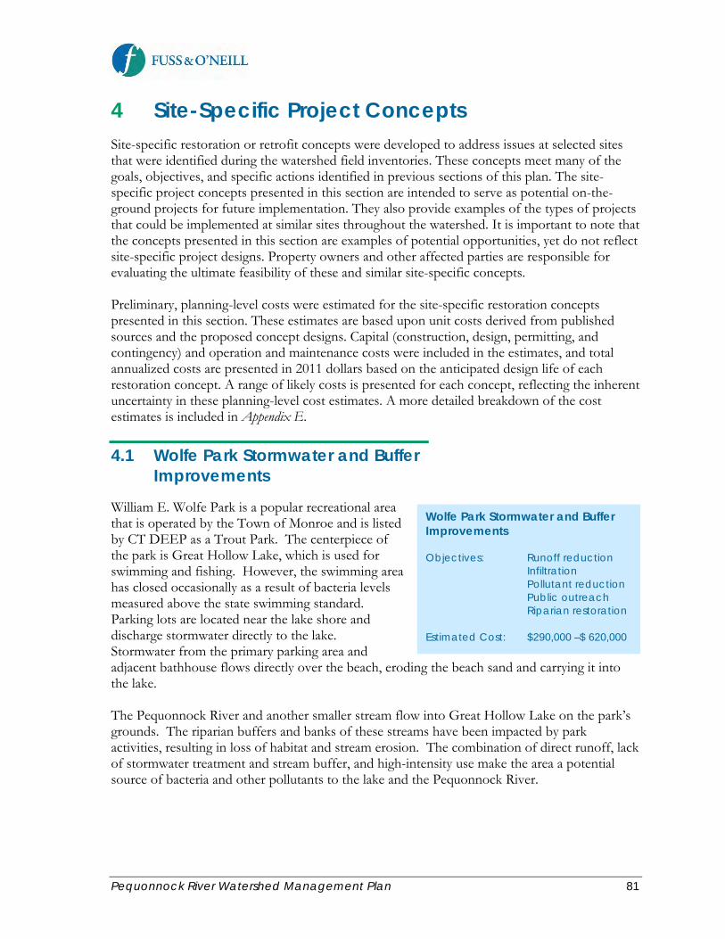
Pequonnock River Watershed Management Plan 81
4 Site-Specific Project Concepts Site-specific restoration or retrofit concepts were developed to address issues at selected sites that were identified during the watershed field inventories. These concepts meet many of the goals, objectives, and specific actions identified in previous sections of this plan. The site-specific project concepts presented in this section are intended to serve as potential on-the-ground projects for future implementation. They also provide examples of the types of projects that could be implemented at similar sites throughout the watershed. It is important to note that the concepts presented in this section are examples of potential opportunities, yet do not reflect site-specific project designs. Property owners and other affected parties are responsible for evaluating the ultimate feasibility of these and similar site-specific concepts. Preliminary, planning-level costs were estimated for the site-specific restoration concepts presented in this section. These estimates are based upon unit costs derived from published sources and the proposed concept designs. Capital (construction, design, permitting, and contingency) and operation and maintenance costs were included in the estimates, and total annualized costs are presented in 2011 dollars based on the anticipated design life of each restoration concept. A range of likely costs is presented for each concept, reflecting the inherent uncertainty in these planning-level cost estimates. A more detailed breakdown of the cost estimates is included in Appendix E.
4.1 Wolfe Park Stormwater and Buffer Improvements
William E. Wolfe Park is a popular recreational area that is operated by the Town of Monroe and is listed by CT DEEP as a Trout Park. The centerpiece of the park is Great Hollow Lake, which is used for swimming and fishing. However, the swimming area has closed occasionally as a result of bacteria levels measured above the state swimming standard. Parking lots are located near the lake shore and discharge stormwater directly to the lake. Stormwater from the primary parking area and adjacent bathhouse flows directly over the beach, eroding the beach sand and carrying it into the lake. The Pequonnock River and another smaller stream flow into Great Hollow Lake on the park’s grounds. The riparian buffers and banks of these streams have been impacted by park activities, resulting in loss of habitat and stream erosion. The combination of direct runoff, lack of stormwater treatment and stream buffer, and high-intensity use make the area a potential source of bacteria and other pollutants to the lake and the Pequonnock River.
Wolfe Park Stormwater and Buffer Improvements Objectives: Runoff reduction Infiltration Pollutant reduction Public outreach Riparian restoration Estimated Cost: $290,000 –$ 620,000
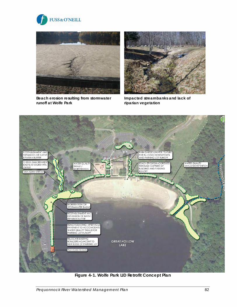
Pequonnock River Watershed Management Plan 82
Beach erosion resulting from stormwater runoff at Wolfe Park
Impacted streambanks and lack of riparian vegetation
Figure 4-1. Wolfe Park LID Retrofit Concept Plan

Pequonnock River Watershed Management Plan 83
Additionally, the reach of the Pequonnock River between Stepney Pond and Great Hollow Lake is designated in the 2010 Connecticut Integrated Water Quality Report as not meeting recreational uses as a result of E. Coli bacteria, but with no known source. As discussed in the Baseline Watershed Assessment Report, the Pequonnock River riparian area upstream of Wolfe Park contains a mixture of forest and forested wetlands. Development encroachments along this reach are generally limited to residential development around Stepney Pond, Cutler’s Farm Road and agricultural land uses located immediately north of the road, and Wolfe Park itself. Wolfe Park is one of the only publically-owned sites along this impaired reach of the Pequonnock River and is therefore a good retrofit/restoration candidate to address the bacteria impairment. The proposed concept for addressing the stormwater and riparian buffer issues at the Great Hollow Lake area of Wolfe Park, shown in Figure 4-1, include the use of LID elements to treat and infiltrate stormwater runoff near the Pequonnock River inflow at Great Hollow Lake. An existing leaching field for an on-site wastewater system at the park is located between the parking lot and the beach and may limit the available area for some of the proposed rain gardens and water quality swales. The proposed Wolfe Park concept consists of the following elements: Boat Ramp Pervious Pavers. Boat ramps tend to be intensively-used on weekends and holidays during the summer but sparsely-used at other times. They also serve as direct sources of runoff into the adjacent water bodies. The existing boat ramp at Great Hollow Lake could be replaced with concrete grid pavers, which are interlocking concrete blocks that have relatively large openings between blocks to allow water to infiltrate into the subsurface. The openings could be vegetated or, if the intensity of use is such that vegetation would not adequately establish, filled with stone of a relatively uniform particle size. Pervious pavers would reduce the quantity of direct runoff to the lake and provide filtering action in the subsurface to reduce stormwater pollutant loads. Bath House Rain Gardens. Rain gardens, also known as bioretention areas, are landscape features that are designed to capture, infiltrate, and treat stormwater from adjacent developed areas. They generally consist of a planting bed, set a few inches to a few feet below the surrounding ground surface, constructed of a mulch layer, an engineered soil media planted with water-tolerant native plant species, and a subsurface drainage layer. During and immediately following a rainstorm, stormwater accumulates in the planting bed, forming a pool, and drains into the soil media. The soil media is designed to allow stormwater to infiltrate into the underlying native soil, while filtering out particulate pollutants, adsorbing other pollutants (adsorption is the bonding of compounds to a surface, while absorption is the intake of a compound into a matrix), encouraging beneficial bacteria to degrade hydrocarbons, and allowing the plant roots to take up dissolved nutrients and other pollutants. This combination of processes makes bioretention areas effective at reducing the quantity of runoff and removing pollutants, including pathogenic bacteria. If the permeability of the native underlying soils is too low to allow adequate infiltration rates, an underdrain can be included in the design to convey treated stormwater to a larger infiltration gallery or to a surface drain.

Pequonnock River Watershed Management Plan 84
The bath house grounds and adjacent parking lots provide opportunities for rain garden retrofits to capture runoff from the building and paved areas, as shown in Figure 4-1. Infiltrating this runoff would address the ongoing beach erosion that may be carrying bacteria and contributing to beach closures. Water Quality Swale Enhancement. A ditch surrounds portions of the beach at Great Hollow Lake to divert runoff from lawn areas around the beach and help reduce erosion of the sand. However, the ditches could be upgraded to grass drainage channels or water quality swales to improve their function. Upgrading the ditches to a grassed drainage channel would require widening the ditches and improving the soils to allow vegetation to grow. Grass drainage channels are not intended to provide infiltration, but rather provide non-erosive conveyance, which is an improvement over the existing ditches. Upgrading the ditches to water quality swales, which are wider than grass drainage channels, would provide infiltration and treatment of stormwater for smaller storms, reducing the frequency of direct discharges to the Pequonnock River and Great Hollow Lake.
Figure 4-2. Existing Conditions at the Westerly Stream Entering Great Hollow Lake
Riparian Restoration. The two watercourses that feed Great Hollow Lake within Wolfe Park – the Pequonnock River and an unnamed stream – have severely impacted banks and riparian areas within the park resulting from landscaping practices that did not consider the function and value of riparian areas. Restoration of the bank and riparian areas would likely include removal of some of the existing hard armoring, such as the boulders that line the Pequonnock River reach upstream from the lake, and installing dense plantings of native shrubs and herbaceous plants that would stabilize the bank’s soils with a network of roots and grow up to shade the stream.

Pequonnock River Watershed Management Plan 85
Figure 4-3. Proposed Stream Restoration Concept
Figure 4-4. Existing Conditions and Proposed Concept for Great Hollow Lake Shoreline Restoration
It may be necessary to leave some of the existing stones in place below the river’s mean annual high water line to prevent erosion in areas where establishing plants may be difficult. While plants are establishing, coir fiber rolls staked to the banks would prevent erosion on steeper slopes. Upslope from the bank, a riparian buffer of native trees and shrubs could replace the existing grass to better slow direct stormwater runoff and provide improved stormwater

Pequonnock River Watershed Management Plan 86
treatment and infiltration. Additionally, areas of the Great Hollow Lake shoreline have been impacted in the same manner as the riparian buffers. These shore areas could be restored in a similar manner.
Figure 4-5. Typical Bank Restoration Planting for Small Streams In the impacted portion of the unnamed stream entering Great Hollow Lake from the north, a stormwater outfall discharges adjacent to the stream. Small check dam sediment basins could be added at the outfall to capture and remove larger particles from the stormwater discharge prior to entering the stream.
4.2 Stepney Elementary School Greenscaping
Stepney Elementary School in Monroe is a three-wing structure with a loop road for school bus drop-off, a faculty parking lot, paved play yard, and small athletic fields. The area surrounding the school grounds are well-forested. The Housatonic Valley Rail Trail is located approximately 250 yards to the east, and the East Branch of the Pequonnock River is located approximately ¼ mile to the west. The school building is large and low, and, combined with the parking areas and roads, the site has relatively high impervious coverage. The condition of the grass in the school’s yard areas is generally poor, with large bare patches and signs of erosion. Stormwater is managed through a traditional curb and gutter drainage system with no detention, infiltration, or water quality treatment.
Stepney Elementary School Greenscaping Objectives: Runoff reduction Infiltration Pollutant reduction Education Habitat improvement Estimated Cost: $320,000 –$ 680,000

Pequonnock River Watershed Management Plan 87
A proposed concept for improving stormwater management and habitat conditions at the school includes the following elements. Bioretention and Water Quality Swales. Construct bioretention areas in traffic islands between parking areas and the bus drop-off loop to capture, treat, and infiltrate stormwater. Construct water quality swales at the perimeter of the school’s yard areas to capture runoff and sediment from the school’s grounds.
Figure 4-6. Stepney Elementary School Greening Concept Pervious Pavement. A variety of materials are available to replace conventional paved surfaces (roadway, driveway, and parking) with pervious pavement. Interlocking concrete grid pavers are described in the previous section. Pervious pavement material should be selected based on the characteristics of the application. The block pavers described previously are easy to install and relatively inexpensive, but are suitable for applications where vehicle traffic is relatively light.

Pequonnock River Watershed Management Plan 88
Figure 4-7. Diagrams of Selected Permeable Pavement Systems
Parking spaces in urban areas can be paved with open-jointed block pavers, which are more attractive than pervious asphalt or concrete, but provide a smoother surface and are somewhat more suited to constant vehicle use, although at slow speeds. For areas where heavier traffic loads are anticipated, pervious asphalt or pervious concrete may be more appropriate. These pavements are similar to common asphalt and concrete but are much more permeable and can be used for roadway surfaces. These materials could be used at the school’s entrance and exit to intercept and infiltrate stormwater that currently discharges to the Old Newtown Road drainage system.

Pequonnock River Watershed Management Plan 89
Bart Shopping Center LID Retrofits Objectives: Runoff reduction Infiltration Pollutant reduction Education Habitat improvement Estimated Cost: $340,000 –$ 730,000
Woodland Edge Planting. Since the school grounds are surrounded by a dense wooded area, the edge of the woods along the less-intensively used portion of the school grounds provides an opportunity to create woodland edge habitat. Woodland edge habitat consists of early successional plants, typically consisting of shrubs and vines and young forest tree species. Planned and maintained woodland edges can prevent establishment of invasive species and nuisance species that can thrive in the conditions provided at the edges of fields. Establishment of the woodland edge along the school grounds could also serve as an educational feature that could be incorporated into the school’s science and environmental curriculum.
4.3 Bart Shopping Center LID Retrofits
The Bart Shopping Center is a typical suburban-commercial strip mall along Main Street in Monroe. The shopping center buildings and parking lots form a large contiguous impervious area with no treatment or infiltration of stormwater runoff. The proposed retrofit concept for this site, shown in Figure 4-8, is intended to treat and infiltrate stormwater using the limited area available.
Figure 4-8. Bart Shopping Center LID Retrofit Concept

Pequonnock River Watershed Management Plan 90
Pervious pavement aprons could be constructed along Main Street to infiltrate parking lot runoff prior to leaving the site. Bioretention areas could be constructed at the northern and southern limits of the site’s developed area to treat and infiltrate additional runoff. The concept also includes a green gutter along Main Street and a combined pervious pavement parking strip and water quality swale along the back of the facility. Green Gutters (Figure 4-9) can help capture and slow stormwater runoff within narrow and shallow landscaped areas in parking lots or along a street’s edge. Green gutters are designed to be very shallow with little or no water retention. Their primary purpose is to help filter out pollutants and slow the flow of water. The strip within the gutter serves as a compact bioretention area, providing stormwater treatment and infiltration. If underlying soils are slow-draining, an underdrain can be installed to convey filtered stormwater to the storm drainage system.
Figure 4-9. Typical Green Gutter Cross Section Pervious Pavement in parking rows can be enhanced through the use of a water quality swale or bioretention if underlying soils are not conducive to infiltration (see Figure 4-10). The swale can receive infiltrated water flowing below the pavement subgrade, increasing the volume of stormwater storage in the system above the native soil.
Figure 4-10. Typical Pervious Parking Row Cross Section

Pequonnock River Watershed Management Plan 91
4.4 Beardsley Park LID Retrofits
Beardsley Park and Beardsley Zoo, which attracts thousands of visitors annually from throughout Connecticut and the region, offers numerous opportunities for LID retrofits that could benefit water quality in Bunnell’s Pond on the Lower Pequonnock River and provide far-reaching educational and outreach benefits. The zoo grounds already include a rain garden that was constructed as part of a NEMO workshop. The site has several heavily-used parking lots that discharge untreated stormwater to Bunnell’s Pond or the Pequonnock River. The park also has a network of slow-speed, scenic roadways that make up a large amount of impervious cover and encroach on the river. Maintained lawn areas along the river and pond provide poor riparian habitat, encouraging use by nuisance waterfowl such as geese and seagulls.
Waterfowl are attracted by the poor understory along a wooded section of the Bunnell’s Pond bank
A traffic island in the Beardsley Zoo parking lot provides an excellent opportunity for an LID retrofit
A proposed retrofit concept for Beardsley Park and Zoo includes the following elements. Implementation of these types of retrofits should be consistent with the City’s parks master planning efforts. Riparian Restoration. The riparian fringe along Bunnell’s Pond and the Pequonnock River could be significantly improved by replacing some of the existing lawn areas with shrubs and taller herbaceous material to deter gulls and geese from these areas, as well as improve habitat for other species. Riparian enhancements should be designed to balance water quality and habitat benefits with park usage.
Beardsley Park LID Retrofits Objectives: Runoff reduction Infiltration Pollutant reduction Public outreach Habitat improvement Waterfowl deterrence Estimated Cost: Park Component: $540,000 –$1,150,000 Zoo Component: $130,000 - $280,000
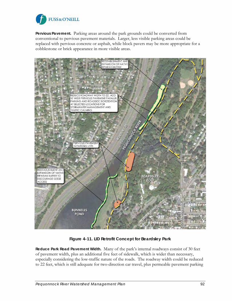
Pequonnock River Watershed Management Plan 92
Pervious Pavement. Parking areas around the park grounds could be converted from conventional to pervious pavement materials. Larger, less visible parking areas could be replaced with pervious concrete or asphalt, while block pavers may be more appropriate for a cobblestone or brick appearance in more visible areas.
Figure 4-11. LID Retrofit Concept for Beardsley Park Reduce Park Road Pavement Width. Many of the park’s internal roadways consist of 30 feet of pavement width, plus an additional five feet of sidewalk, which is wider than necessary, especially considering the low-traffic nature of the roads. The roadway width could be reduced to 22 feet, which is still adequate for two-direction car travel, plus permeable pavement parking

Pequonnock River Watershed Management Plan 93
lanes if necessary in certain areas. Such a modification could reduce the amount of impervious surface by approximately 1 acre per mile of roadway. Bioretention. A circular traffic island is located within the Beardsley Zoo main parking area. This island, which is currently raised, could be converted into a bioretention area to capture, treat, and infiltrate runoff from the adjacent parking lot. If an underdrain is needed, a nearby catch basin within the existing drainage system could be used to receive the discharge. A second catch basin is located adjacent to a landscaped area near the circular traffic island. The catch basin could be converted to a tree box filter. A typical schematic of a tree box filter is shown in Figure 4-12. Tree box filters are a form of bioretention, consisting of precast concrete planters with tops that install flush with the sidewalk to provide a continuous walking surface and a side inlet that replaces the curb along the street. The majority of the device is below ground and includes a soil media to support tree growth and for pollutant removal via filtration. The curb inlet allows stormwater to enter the tree box filter. Trash and debris is deposited on top of the soil media and can be removed, while stormwater is treated as it passes through the soil media. The system can be configured to infiltrate the treated stormwater depending on soil and groundwater conditions.
Source: Hydro International, Inc.
Figure 4-12. Typical Tree Box Filter

Pequonnock River Watershed Management Plan 94
Figure 4-13. Beardsley Zoo Rain Garden and Tree Box Filter Retrofit Concept
4.5 Bridgeport City Hall LID Retrofits
Bridgeport City Hall is a high-traffic location on a constrained site where parking is often near-capacity. City Hall is located in an area that is served by combined sewers. Combined Sewer Overflows (CSOs) from this area discharge to an impaired tidal segment of the Pequonnock River. Retrofitting this site with LID and green infrastructure measures has multiple benefits, including reducing the quantity of stormwater discharging to combined sewers, which would in turn lead to a reduction in the quantity and frequency of CSO discharges to the river, plus providing educational outreach opportunities for municipal employees and the public. A green roof concept for Bridgeport City Hall is shown in Figure 4-14 and 4-15, and an overall LID retrofit concept for Bridgeport City Hall and the surrounding area is shown in Figure 4-16. These proposed concepts could be modeled after the recently constructed Green Capitols project at the Connecticut State Capitol Building in Hartford. Green Roof. Bridgeport City Hall, and other public buildings with large flat roofs, are potential candidates for green roof retrofits. Green roofs are engineered planting systems that can be installed on buildings to absorb and retain rainwater, reducing peak stormwater flows and runoff volumes. Green roofs are more costly than conventional roofs but they are capable of
Bridgeport City Hall LID Retrofits Objectives: Runoff reduction Infiltration Pollutant reduction Public outreach Estimated Cost: $210,000 - $460,000 Excluding green roof

Pequonnock River Watershed Management Plan 95
absorbing and retaining large amounts of stormwater. In addition, green roofs provide sustainability benefits such as absorbing air and noise pollution, rooftop cooling by reducing ultraviolet radiation absorption, creating living environments for birds, and increasing the quality-of-life for residents. If the City pursues installation of other green measures on the City Hall building roof, such as photovoltaic panels, a green roof of reduced size could be incorporated on remaining roof areas. Blue roofs are non-vegetated rooftop source controls that detain stormwater. Weirs at the roof drain inlets and along the roof can create temporary ponding and gradual release of stormwater. Blue roofs are less costly than green roofs. Coupled with light colored roofing material they can provide sustainability benefits through rooftop cooling. New York City has begun to use blue roofs as part of its green infrastructure strategy for addressing CSOs and stormwater management.
Figure 4-14. Bridgeport City Hall Green Roof Retrofit Concept
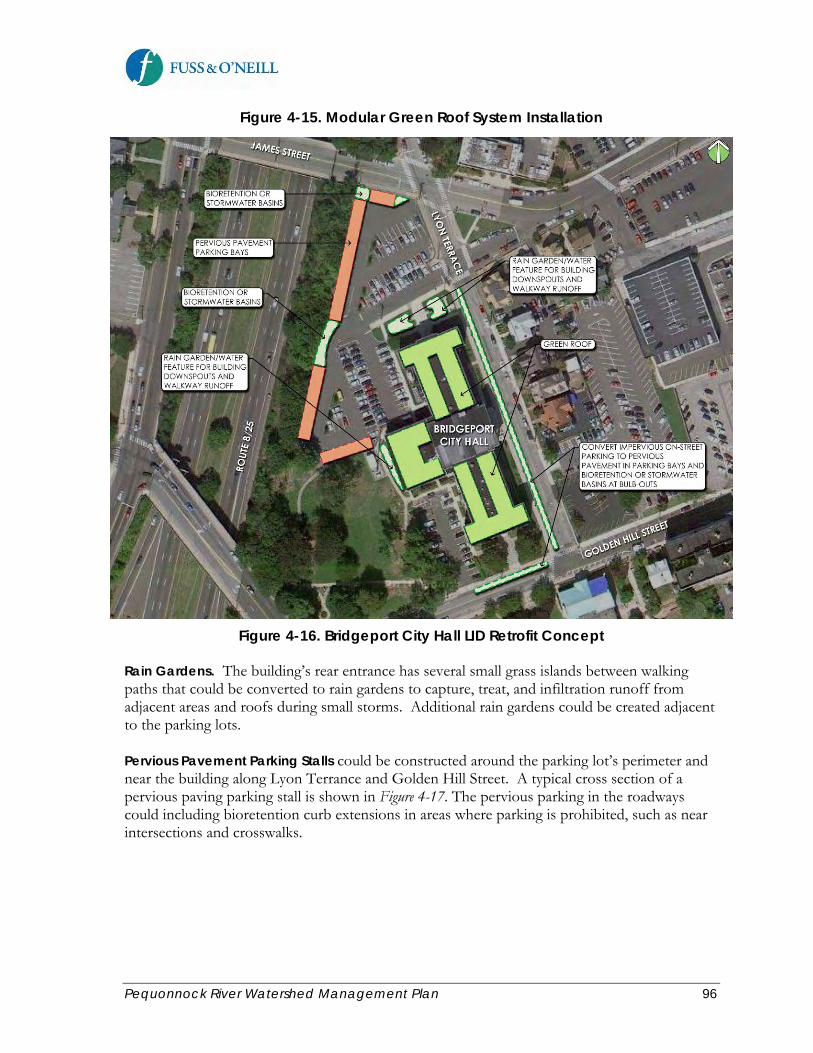
Pequonnock River Watershed Management Plan 96
Figure 4-15. Modular Green Roof System Installation
Figure 4-16. Bridgeport City Hall LID Retrofit Concept Rain Gardens. The building’s rear entrance has several small grass islands between walking paths that could be converted to rain gardens to capture, treat, and infiltration runoff from adjacent areas and roofs during small storms. Additional rain gardens could be created adjacent to the parking lots. Pervious Pavement Parking Stalls could be constructed around the parking lot’s perimeter and near the building along Lyon Terrance and Golden Hill Street. A typical cross section of a pervious paving parking stall is shown in Figure 4-17. The pervious parking in the roadways could including bioretention curb extensions in areas where parking is prohibited, such as near intersections and crosswalks.
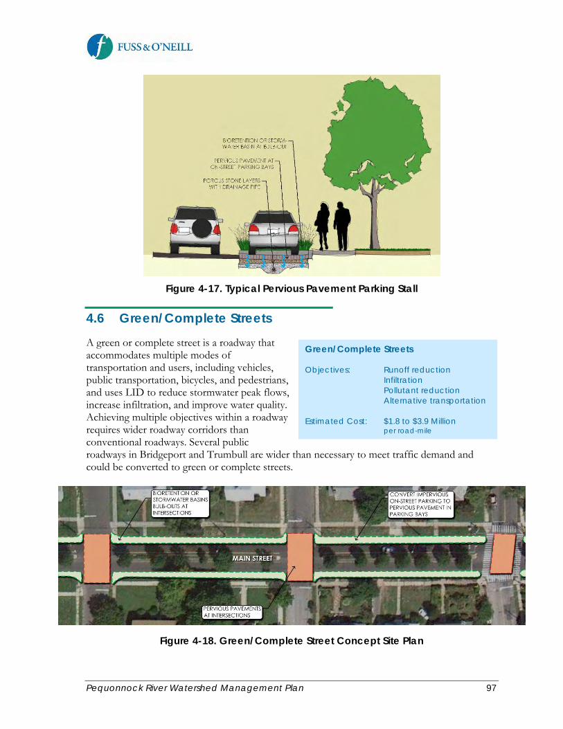
Pequonnock River Watershed Management Plan 97
Figure 4-17. Typical Pervious Pavement Parking Stall
4.6 Green/Complete Streets
A green or complete street is a roadway that accommodates multiple modes of transportation and users, including vehicles, public transportation, bicycles, and pedestrians, and uses LID to reduce stormwater peak flows, increase infiltration, and improve water quality. Achieving multiple objectives within a roadway requires wider roadway corridors than conventional roadways. Several public roadways in Bridgeport and Trumbull are wider than necessary to meet traffic demand and could be converted to green or complete streets.
Figure 4-18. Green/Complete Street Concept Site Plan
Green/Complete Streets Objectives: Runoff reduction Infiltration Pollutant reduction Alternative transportation Estimated Cost: $1.8 to $3.9 Million per road-mile

Pequonnock River Watershed Management Plan 98
Figure 4-19. Green/Complete Street Concept for Lincoln Boulevard
Figure 4-20. Green/Complete Street Cross Section
The green/complete street concept developed for this watershed management plan includes a combination of pervious pavement at intersections, bicycle lanes, retention of sidewalks,

Pequonnock River Watershed Management Plan 99
bioretention curb extensions or “bulb-outs” and pervious parking bays, green gutters, and retaining or adding a planted median island. The City of Bridgeport is undertaking a green/complete streets program as part of its city-wide sustainability initiatives. Green streets have been constructed along Park Avenue. Additional green/complete streets projects are planned along Park Avenue and the Park Avenue/Railroad Avenue areas of the City.
4.7 Trumbull Public Library LID
The Town of Trumbull is undertaking a parking lot expansion project at the Trumbull Public Library. This project will increase the impervious cover at the site, as well as require removal of several mature shade trees. Funding for the initial phase of the project is limited, but later phases could include LID retrofits such as those shown in Figure 4-21.
Figure 4-21. Trumbull Library LID Concept
Trumbull Public Library LID Objectives: Mitigation Runoff reduction Infiltration Pollutant reduction Public outreach Estimated Cost: $275,000 - $590,000 Including proprietary Tree box filters

Pequonnock River Watershed Management Plan 100
The Town of Trumbull has evaluated the use of tree box filters along the edge of the parking lot to capture, treat, and infiltrate stormwater runoff from the additional impervious area and for the planting of new shade trees. Due to the relatively high cost of proprietary tree box filters, the Town is considering an adaptation of this concept using readily-available landscape materials. Pervious pavement will also be considered for future retrofits. The new parking area will have a landscaped island in between parking rows. The Town has proposed planting shade trees in this island. Since only a narrow space is available between the parking rows, structural soil is proposed to accommodate larger trees by allowing for deeper root growth without damaging the overlying pavement. In addition to these LID measures, there are also opportunities at this site to construct water quality swales or bioretention areas along Church Hill Road to manage and runoff from the adjacent roads.
4.8 Old Mine Park Restoration
Old Mine Park, also known as Tungsten Mine Park, in Trumbull is a large open space area located between Route 25 to the south, a residential neighborhood to the east, and a commercial area to the north. The park is mostly wooded but includes a small run-of-river impoundment along the Pequonnock River’s main stem with parking to the south, an athletic field to the north, and a small footbridge over the river. The impoundment was once a popular swimming hole but was closed in the 1980s due to high bacteria levels. The impoundment is at the upstream end of a reach that is impaired for aquatic habitat, with the cause of the impairment being unknown. In 2010, the impoundment was dredged without the use of appropriate best management practices, resulting in impacts to the river’s banks and the discharge of sediment downstream. Within the park, the river’s banks and riparian area are in poor condition, with lawn to the water’s edge. A retrofit concept (Figure 4-22) was developed for Old Mine Park to address the degraded riparian habitat, to capture, treat, and infiltrate stormwater, and to restore the banks impacted by the recent dredging. The concept maintains public access to the river at selected locations. The concept includes construction of a grass drainage swale to intercept runoff from the parking area and convey it to a proposed rain garden. The banks of the Pequonnock River would be restored with native shrubs and herbaceous plants to stabilize the soils and improve habitat. A combination of shrubs and meadow grasses would be planted in the riparian area of the stream, and walking paths would be constructed to promote access at limited locations to establish and maintenance the vegetation. The value of a riparian buffer will be explained as part of the interpretive sign that would be installed at the site. Figure 4-23 provides a rendering of the concept.
Old Mine Park Restoration Objectives: Stream restoration Runoff reduction Infiltration Pollutant reduction Public outreach Public access Estimated Cost: $200,000 - $425,000

Pequonnock River Watershed Management Plan 101
Figure 4-22. Old Mine Park Restoration Concept Site Plan
Figure 4-23. Old Mine Park Restoration Concept Rendering

Pequonnock River Watershed Management Plan 102
4.9 Knowlton Park
The City of Bridgeport is developing a master plan for redevelopment of a former industrial area on Knowlton Street into a waterfront park along the Lower Pequonnock River. The site contains a number of abandoned or under-utilized former industrial properties along the east side of the Pequonnock River. The site is within an area served by combined sanitary and storm sewers. Figure 4-24 depicts existing conditions at the site. The proposed concept for the Knowlton Park developed by the City (Figure 4-25) includes a variety of uses that are appropriate for the park’s location. The park’s location is adjacent to a densely-developed inner city area where residents have little access to open space, so the park will include a basketball court, playground, and lawn area.
Source: Bing Maps
Figure 4-24. Knowlton Park – Existing Conditions
Knowlton Park Objectives: Public access Stream restoration Runoff reduction Infiltration Mitigation Pollutant reduction Public outreach Estimated Cost: $310,000 – $650,000 LID elements only

Pequonnock River Watershed Management Plan 103
Figure 4-25. Knowlton Park Proposed Concept Plan Under the proposed master plan concept, the site would be redeveloped in phases. An existing derelict dock would be restored to provide fishing access to the river. Access to the river would also be provided via an overlook pavilion and surrounding plaza. LID stormwater management elements, such as rain gardens, would be incorporated into the park’s grounds to manage runoff. The portion of Knowlton Street along the park would be converted to a green street with pervious pavement parking bays, reduced pavement width, and bioretention curb extensions at the crosswalk leading to the park’s main entrance. Pavement at the intersection with Arctic Street would be converted to pervious pavement. The bank of the river would be restored with riparian plantings, while maintaining lawn areas for recreational use. The park design would and operation would incorporate nuisance waterfowl control measures. Future phases of the project include providing continuous access along the river via a mixed use trail that would pass over the water at intervals on a pile-supported boardwalk.

Pequonnock River Watershed Management Plan 104
4.10 Regional Stormwater Retrofits
Utility mapping obtained from the City of Bridgeport was used to identify potential locations for larger, regional stormwater retrofits that could be installed at the downstream end of an existing drainage system that serves multiple sites or neighborhoods. Several drainage areas were identified based on the following criteria: (1) within areas of separated storm sewer (i.e., not in areas of combined storm and sanitary sewers), (2) near or within the Pequonnock River corridor, and (3) upgradient from vacant or underutilized parcels where a stormwater retrofit could be constructed. The following describes the identified areas, which are shown in Figure 4-26 and Figure 4-27, and the potential types of retrofits that could be implemented in these locations.
Figure 4-26. Slawson Street and Hawley Avenue Retrofit Areas
Slawson Street is an underused street in a residential area that leads into a vacant parcel. Upgradient from this parcel is a drainage area of approximately 56 acres that City mapping indicates is drained through separate storm sewers. A diversion structure could be installed in the existing storm drainage line, sending flows to a new stormwater basin on the vacant parcel to detain, treat, and potentially infiltrate stormwater. The diversion structure would be designed
Regional Stormwater Retrofits Objectives: Stormwater treatment Peak flow control Infiltration Estimated Costs: Slawson Street: $1.3 - $2.8 million Hawley Ave: $1.7 - $3.5 million Route 8: $0.8 – 1.7 million Housatonic Ave: $0.6 – 1.4 million

Pequonnock River Watershed Management Plan 105
to bypass stormwater from precipitation events greater than the design storm could bypass the diversion so as not to mobilize accumulated sediment. A storm drainage line on Hawley Avenue receives stormwater from an area of approximately 59 acres that currently discharges directly to the Pequonnock River. A former vacant parcel is located nearby. The parcel has recently been cleared for use as a contractor storage yard. A diversion structure could be installed in the existing Hawley Avenue drainage system and a new segment of pipe added to convey stormwater to the former vacant parcel, where an extended detention basin or constructed wetland could be constructed to receive and treat stormwater, and riparian vegetation restored. The contractor yard would need to be relocated to another parcel.
Figure 4-27. Route 8 and Housatonic Avenue Retrofit Areas Route 8 through Bridgeport is drained through a CTDOT-operated separate drainage system that discharges directly to the Pequonnock River, likely via Washington Avenue. Two parcels are located adjacent to the river on the north and south sides of Washington Avenue. The parcel on the south side is vacant, while the parcel on the north side serves as an outdoor material storage area for a commercial business. Drainage could be diverted from the storm drainage line to an extended detention basin, constructed wetland, or underground detention system on the vacant parcel or an underground detention system on the northern parcel.

Pequonnock River Watershed Management Plan 106
A large vacant parcel on Housatonic Avenue may also provide opportunity to infiltrate stormwater from an upgradient drainage system, although this location is less preferable since it is located somewhat upgradient in the drainage system and the parcel has a cross-slope.
4.11 Water Street Green Infrastructure
The City of Bridgeport is developing an intermodal transportation center along Water Street that integrates commuter rail, high speed rail, ferry, bus, passenger vehicle, and pedestrian transportation modes. A pedestrian connection below the Interstate 95 overpass was recently constructed to connect these uses. Drainage from the overpass is discharged into the area of the pedestrian connection.
Figure 4-28. Water Street Green Infrastructure Concept Plan The City prepared a design concept to improve the pedestrian area and include management of stormwater from the downspouts as a landscape feature. Proposed measures included “weeping walls,” over which stormwater would cascade (Figure 4-29), and a stone biofiltration swale that would capture and treat runoff. Ultimately, limited funds were available for implementation of the project and some of these components were not included in the final design. Future phases of the project could incorporate these or similar green infrastructure elements.
Water Street Green Infrastructure Objectives: Public outreach Stormwater treatment Estimated Cost: $320,000 additional

Pequonnock River Watershed Management Plan 107
4-29. Water Street Green Infrastructure Concept Rendering

Pequonnock River Watershed Management Plan 108
5 Pollutant Load Reductions Pollutant load reductions were estimated for the following watershed management plan recommendations using the Watershed Treatment Model (WTM) pollutant loading model described in the baseline watershed assessment report. Anticipated pollutant load reductions were modeled using WTM for the following watershed management plan recommendations. Other recommended actions identified in this plan could not be quantified due to inherent limitations of WTM and/or the lack of reliable input data or information on the pollutant removal effectiveness of certain practices.
1. CSO Abatement. The Water Pollution Control Authority (WPCA) CSO Long Term Control Plan (LTCP) for the City of Bridgeport is designed to eliminate CSOs during storms up to the typical one-year frequency event. This will reduce the number of CSOs to approximately 1 event on an annual average basis.
2. Green Infrastructure/Low Impact Development (LID) Retrofits. Stormwater retrofits are
recommended throughout the watershed on public land (municipal, institutional, and transportation land uses), identified or potential hotspots (commercial and industrial land uses), and residential properties. Potential pollutant load and runoff reductions were estimated for a variety of green infrastructure and LID retrofit practices, including:
• Green roofs, bioretention, and infiltration – public and institutional land • Vegetated filter strips, bioretention – transportation land use • Roof disconnection and bioretention – commercial & industrial land uses • Rain barrels and roof disconnection – residential land use
Multiple scenarios were modeled to estimate the effect of varying levels of retrofit implementation across the watershed, including estimates for retrofitting 5%, 10%, 50%, and 100% of the watershed impervious area. The modeled effectiveness of the proposed retrofits was reduced to reflect system maintenance and design (system bypass during larger storms) factors.
3. Stormwater Management for New Development and Redevelopment. The watershed
management plan promotes effective stormwater management for future development and redevelopment throughout the watershed through land use regulatory mechanisms and the local site plan review process. Potential load reductions were estimated for implementation of stormwater management practices for future new development and redevelopment in the watershed, based on the watershed buildout presented in the baseline assessment report. The target effectiveness of the proposed stormwater controls were estimated from the Rhode Island Stormwater Design And Installation Standards Manual (RIDEM, 2010) as a 30% reduction in nutrients (TN and TP), an 85% reduction in TSS, a 60% reduction in bacteria, and a 25% reduction in runoff volume. The effectiveness reflects system maintenance and design inefficiencies and assumes that 80% of new development requires stormwater management practices.
Pequonnock River Watershed Management Plan 109
4. Riparian Buffer Restoration. Potential pollutant load reductions were estimated for restoration of impacted riparian buffers in the watershed. The total length of streams within each subwatershed with impacted buffers was estimated from aerial photography. Under the modeled restoration scenario, a 100-foot vegetative riparian buffer was assumed for those areas currently with impacted buffers.
5. Reforestation. The watershed management plan promotes preservation and
enhancement of tree canopy through various urban watershed forestry approaches. Potential pollutant load reduction benefits were estimated for a watershed reforestation scenario, using the tree canopy goals presented in the baseline assessment report as a future target. The amount of land conversion required to achieve the recommended tree canopy goal was modeled by converting future anticipated institutional (including municipal) and some commercial land use to a forested condition.
6. Open Space Protection. Potential pollutant load reductions were estimated for an open
space protection scenario consistent with the open space recommendations in Section 3.4.4 of this plan. Parcels recommended for acquisition as protected open space or conservation restrictions were assumed to remain in their current land use as forest or undeveloped open space under a future watershed buildout scenario. Predicted future pollutant loads from these parcels under a “protection” scenario were compared to predicted future loads under a future buildout scenario in which the land is assumed to be developed as allowed by current zoning.
7. Public Education. Pet waste, lawn care, and other nonpoint source education programs
can change behaviors that affect pollutant loads. Pollutant load reductions were estimated for pet waste and lawn care education programs based on the number of dwellings, average fraction of pet-owners, pet-owners who already clean up after their pets, and average fraction willing to change their behavior. Conservative model assumptions were used to avoid over-estimating the load reduction benefits of these programs.
8. Illicit Discharge Detection and Elimination. Illicit stormwater connection removal was
considered in each subwatershed based on the existing estimated number of illicit connections associated with commercial and residential land uses. The illicit connection removal scenario assumes that 20% of the existing illicit discharges are detected and eliminated.
9. Septic System Repairs. Septic system repairs were considered in each subwatershed
based on the existing estimated number of households served by septic systems. The septic system repair scenario assumes that 20% of the failing septic systems are repaired. This scenario reflects short or mid-term recommendations to address existing failing or malfunctioning septic systems. Potential long-term elimination of septic systems in the watershed is addressed in Item 10 below.
10. Formation of a Regional WPCA and Elimination of Septic Systems. As described in this
plan, Bridgeport, Monroe and Trumbull are exploring the possibility of creating a regional water pollution control authority modeled after the Greater New Haven

Pequonnock River Watershed Management Plan 110
WPCA. The independent agency would centralize all sewer operations for the municipalities and extend sewer service into the unsewered portions of Trumbull and to Monroe, eventually eliminating on-site septic systems in both communities.
Annual average pollutant loads for bacteria, total suspended solids (TSS), phosphorus (P), and nitrogen (N) and average annual runoff volume were estimated for 1) existing conditions, 2) future buildout of the watershed without the proposed watershed management plan recommendations, and 3) future buildout assuming implementation of the proposed watershed management plan recommendations described in the above scenarios. Table 5-1 summarizes the anticipated pollutant load reductions for the plan recommendations for which pollutant loads can be reasonably quantified. The load reduction values presented in Table 5-1 are for the entire Pequonnock River watershed. Load reduction summaries by subwatershed are provided in Appendix F. As indicated in Table 5-1, implementation of the City of Bridgeport CSO abatement program (CSO Long-Term Control Plan or LTCP) is estimated to result in an approximately 47% reduction in fecal coliform loading to the Pequonnock River, compared to existing conditions. Load reductions for the other watershed management recommendations listed in Table 5-1 are expressed as a percentage of the remaining watershed pollutant loads following elimination of CSOs to the Pequonnock River as a result of full implementation of the CSO LTCP. Varying levels of stormwater retrofit implementation across the watershed were modeled, including estimates for retrofitting 5%, 10%, 50%, and 100% of the impervious area in residential, industrial, commercial, institutional, and transportation land uses. The results for the 5% scenario, which is considered a reasonable likely scenario, are included in Table 5-1. The results for all four scenarios are presented in Table 5-2. The 5% retrofit scenario is predicted to result in an approximately 4% reduction in annual bacteria loads and runoff volume watershed-wide. Significantly higher reductions (40% to 80%) could potentially be achieved by retrofitting a much greater percentage of the watershed, although the level of retrofits required to achieve these reductions would likely be cost-prohibitive. Estimated costs for each of the four retrofit scenarios are provided in Appendix E. Long-term elimination of septic systems through the formation of a regional WPCA and expansion of sanitary sewers in the watershed is estimated to result in an approximately 11% reduction in nitrogen loading, 8% reduction in phosphorus loading, and 1% reduction in bacteria loading. In contrast, the anticipated pollutant load reductions associated with an interim septic system repair scenario are roughly four times smaller than the predicted load reductions due to complete elimination of septic systems. Aside from elimination of CSOs, which is predicted to result in the most significant reductions in bacterial loads to the Pequonnock River, reforestation and riparian buffer restoration, stormwater retrofits, and open space protection are the most effective management plan recommendations for reducing bacteria loads. The effectiveness of the watershed management recommendations varies by pollutant, although fecal coliform, nitrogen, and phosphorus load reductions are anticipated to yield the greatest load reduction through the implementation of stormwater controls. In addition, runoff volume is anticipated to decrease significantly through

Pequonnock River Watershed Management Plan 111
the implementation of stormwater management practices, with reforestation predicted to provide the greatest potential reduction.
Table 5-1. Anticipated Annual Pollutant Load Reductions
Watershed Management Recommendation
N (lb/yr)
P (lb/yr)
TSS (lb/yr)
Fecal Coliform
(billion/yr)
Runoff Volume
(ac-in/yr)
N (%)
P (%)
TSS (%)
Fecal Coliform
(%)
Runoff Volume
(%) CSO Abatement 4,701 940 10,137 1,478,338 0 2.9% 2.6% 0.1% 46.7% 0.0% Load reductions for the following management recommendations are expressed as a percentage of the remaining watershed pollutant loads following elimination of CSOs: Green Infrastructure/ LID Retrofits (Retrofit 5% of impervious area) 8,292 1,677 339,434 74,029 12,466 5.0% 4.6% 3.4% 4.2% 4.1% Stormwater Management for New Development and Redevelopment 1,139 213 87,933 25,178 1,220 0.7% 0.6% 0.9% 1.4% 0.4% Riparian Buffer Restoration 4,133 841 169,549 31,117 5,882 2.5% 2.3% 1.7% 1.7% 2.0% Reforestation 11,467 2,722 137,285 302,193 30,337 6.9% 7.5% 1.4% 17.0% 10.1% Open Space Protection 2,356 372 129,602 44,676 4,772 1.4% 1.0% 1.3% 2.5% 1.6% Public Education 674 35 0 789 0 0.4% 0.1% 0.0% 0.0% 0.0% Illicit Discharge Detection and Elimination (IDDE) 174 101 1,631 21,718 0 0.1% 0.3% 0.0% 1.2% 0.0% Septic System Repair 3,742 624 24,948 5,662 0 2.3% 1.7% 0.3% 0.3% 0.0% Formation of a Regional WPCA and Elimination of Septic Systems 18,711 3,118 124,738 23,868 0 11.3% 8.5% 1.3% 1.3% 0.0% Total (excluding CSO Abatement and Septic System Repair) 46,945 9,081 990,172 523,568 54,678 28.4% 24.9% 9.9% 29.4% 18.2%
Total 51,646 10,021 1,000,309 2,001,906 54,678 30.4% 26.8% 10.0% 60.9% 18.2%
Note: Totals include long-term elimination of septic systems and do not include septic system repair.
Table 5-2. Anticipated Annual Pollutant Load Reductions for Varying Levels of Green
Infrastructure/LID Retrofits Green Infrastructure/ LID Retrofits
N (lb/yr)
P (lb/yr)
TSS (lb/yr)
Fecal Coliform
(billion/yr)
Runoff Volume
(ac-in/yr)
N (%)
P (%)
TSS (%)
Fecal Coliform
(%)
Runoff Volume
(%)
Retrofit 5% of Impervious Area
8,292 1,677 339,434 74,029 12,466 5.0% 4.6% 3.4% 4.2% 4.1%
Retrofit 10% of Impervious Area
16,584 3,355 678,869 148,057 24,932 9.8% 9.2% 6.8% 8.3% 8.3%
Retrofit 50% of Impervious Area
82,920 16,774 3,394,343 740,287 124,659 49.0% 46.0% 34.1% 41.6% 41.5%
Retrofit 100% of Impervious Area
165,839 33,547 6,788,686 1,480,575 249,318 98.0% 91.9% 68.2% 83.2% 82.9%
Note: Load reductions for the retrofit scenarios are expressed as a percentage of the remaining watershed pollutant loads following elimination of CSOs.

Pequonnock River Watershed Management Plan 112
Table 5-3 summarizes the anticipated combined effectiveness for all of the watershed management recommendations considered. The pollutant loadings and load reductions presented in Table 5-3 reflect a comparison of modeled future pollutant loadings for the entire Pequonnock River watershed, with and without implementation of the watershed management recommendations under future conditions. Overall, a significant reduction in bacteria loads is anticipated (60.9%), largely due to CSO abatement, with smaller reductions anticipated for nitrogen (30.4%), phosphorus (26.8%), total suspended solids (10.0%), and runoff volume (18.2%).
Table 5-3. Summary of Modeled Pollutant Loads and Load Reductions
Parameter Existing Conditions
Future Buildout without Controls
Future Buildout with
Controls Load
Reduction
Nitrogen (lb/yr) 161,534 169,859 118,214 30.4% Phosphorus (lb/yr) 35,893 37,449 27,428 26.8% TSS (lb/yr) 9,626,351 9,970,375 8,970,066 10.0% Fecal Coliform (billion/yr) 3,162,539 3,287,428 1,285,522 60.9% Runoff Volume (acre-in/year) 283,387 300,336 245,658 18.2%
Note: Totals include long-term elimination of septic systems and do not include septic system repair. Figures 5-1 through 5-5 depict the existing and anticipated future pollutant loads for the watershed, with and without implementation of the watershed management plan recommendations. The pie charts in Figures 5-1 through 5-5 show the relative contribution of the management plan recommendations to the predicted load reductions. Pollutant Load Reductions and Water Quality Impairment Status The primary objective of this watershed management plan is to address the water quality impairments in the Pequonnock River and Bridgeport Harbor in order to restore the recreation and habitat uses that have been lost due to degraded water quality. The pollutant load evaluation suggests that significant pollutant load and runoff reductions could be achieved by implementing the plan recommendations. However, a key question that arises from this evaluation is – will the pollutant load reductions that are anticipated to result from the watershed plan recommendations enable the impaired water bodies to meet their designated uses? Unfortunately, the answer to this question requires a more detailed evaluation, using a linked pollutant loading and a receiving water quality model, to assess the impact of changes in pollutant loads on the water quality of the Pequonnock River and Bridgeport Harbor. Such an evaluation or similar approach, which is beyond the scope of this project, will be required for developing a Total Maximum Daily Load (TMDL) for the impaired segments of the Pequonnock River. The CT DEEP has identified the need to develop a TMDL to address the impairments in the Pequonnock River and Bridgeport Harbor. The TMDL will establish numeric pollutant load reduction targets and recommended implementation action items for the Pequonnock River to attain water quality standards. Future TMDL implementation for the Pequonnock River and

Pequonnock River Watershed Management Plan 113
Bridgeport Harbor can build upon the recommendations of this watershed management plan. Ultimately, the goal of both the watershed-based plan and a future TMDL is to improve water quality of the impaired segments to meet water quality standards and remove the Pequonnock River and Bridgeport Harbor from the impaired waters list.
0
20,000
40,000
60,000
80,000
100,000
120,000
140,000
160,000
180,000
ExistingConditions
FutureBuildoutwithoutControls
FutureBuildout withControls
Nitrogen
(lb/yr)
CSO Abatement
Riparian Buffer Restoration
Open Space Protection
Public Education
Formation of a Regional WPCA and Elimination of Septic Systems
Reforestation
Stormwater Management for New Development and Redevelopment
Green Infrastructure/ LID Retrofits (Retrofit 5% of impervious area)
Illicit Discharge Detection and El imination (IDDE)
30.4% Load Reduction
Distribution of Load Reductions by Management Recommendation
Figure 5-1. Anticipated Nitrogen Loads and Load Reductions
CSO Abatement
Formation of a Regional WPCA and Elimination of Septic Systems
Green Infrastructure/ LID Retrofits (Retrofit 5% of impervious area)
Stormwater Management for New Development and Redevelopment
Public Education
Illicit Discharge Detection and Elimination (IDDE)
Reforestation
Riparian Buffer Restoration
Open Space Protection
0
5,000
10,000
15,000
20,000
25,000
30,000
35,000
40,000
ExistingConditions
FutureBuildoutwithoutControls
FutureBuildout with
Controls
Phosphorus (lb/yr)
26.84% Load Reduction
Distribution of Load Reductions by Management Recommendation
Figure 5-2. Anticipated Phosphorus Loads and Load Reductions

Pequonnock River Watershed Management Plan 114
Riparian Buffer Restoration
Reforestation
CSO Abatement
Green Infrastructure/ LID Retrofits (Retrofit 5% of impervious area)
Open Space Protection
Stormwater Management for New Development and Redevelopment
Illi cit Discharge Detection and Elimination (IDDE)
Formation of a Regional WPCA and Elimination of Sept ic Systems
0
2,000,000
4,000,000
6,000,000
8,000,000
10,000,000
ExistingConditions
FutureBuildoutwithoutControls
FutureBuildout with
Controls
TSS (lb/yr)
10.0% Load Reduction
Distribution of Load Reductions by Management Recommendation
Figure 5-3. Anticipated Sediment (TSS) Loads and Load Reductions
0
500,000
1,000,000
1,500,000
2,000,000
2,500,000
3,000,000
3,500,000
ExistingConditions
FutureBuildoutwithoutControls
FutureBuildout withControls
Fecal Colifo
rm (b
illion/yr) 60.9% Load
Reduction
Formation of a Regional WPCA and Elimination of Septic
Systems
Riparian Buffer Restoration
Reforestation
Green Infrastructure/ LID Retrofits (Retrofit 5% of impervious area)
Stormwater Management for New Development and Redevelopment
CSO Abatement
Public Education
Illicit Discharge Detection and
Elimination (IDDE)
Open Space Protection
Distribution of Load Reductions by Management Recommendation
Figure 5-4. Anticipated Fecal Coliform Loads and Load Reductions

Pequonnock River Watershed Management Plan 115
0
50,000
100,000
150,000
200,000
250,000
300,000
350,000
ExistingConditions
FutureBuildoutwithoutControls
FutureBuildout withControls
Runoff Volum
e (acre‐in/yr)
Reforestation
Open Space Protection
Riparian Buffer Restoration
Green Infrastructure/ LID Retrofits (Retrofit 5% of imperv ious area)
Stormwater Management for New Development and Redevelopment
18.2% Volume Reduction
Distribution of Volume Reductions by Management Recommendation
Figure 5-5. Anticipated Runoff Volumes and Volume Reductions

Pequonnock River Watershed Management Plan 116
6 Schedule, Milestones, and Evaluation Criteria Appendix G contains a proposed implementation schedule, including action items and associated lead entity, timelines, products, and evaluation criteria. This table should be revised as necessary to reflect future changes to the watershed plan and implementation activities. Many different groups will need to participate and collaborate to successfully implement the recommendations identified in this plan. The table in Appendix G identifies a designated lead group(s), which will initiate, obtain the necessary funding for, and organize the necessary resources to implement an action. The lead group is assigned based on the organization or entity whose mission or responsibilities best align with the action and, in the case of a government entity, have jurisdiction over the action or associated geographic area.
7 Funding Sources A variety of local, state, and federal sources are potentially available to provide funding for the implementation of this watershed management plan, in addition to potential funds contributed by local grassroots organizations and concerned citizens. Appendix H contains a list of potential funding sources that has been developed by the CT DEEP and NRCS, and further refined through this planning process. The table is not intended to be an exhaustive list but can be used as a starting point to seek funding opportunities for implementation of the recommendations in this watershed plan. The information presented in this watershed management plan and the supporting study documentation will support future grant proposals by demonstrating a comprehensive, scientifically-based approach for addressing identified concerns consistent with the recommended watershed-based approach. The table of potential funding sources is intended to be a living document that should be updated periodically to reflect the availability of funding or changes to the funding cycle, and to include other funding entities or grant programs.
8 References Center for Land Use Education and Research (CLEAR). 2011. Connecticut’s Changing Landscape – Statewide Land Cover. University of Connecticut. http://clear.uconn.edu/projects/landscape/statewide.htm.
Center for Watershed Protection (CWP). 2004 through 2008. Urban Subwatershed Restoration Manual Series. Ellicott City, MD.
Center for Watershed Protection (CWP). 2004. Illicit Discharge Detection and Elimination - A Guidance Manual for Program Development and Technical Assessments. Ellicott City, Maryland.
Center for Watershed Protection (CWP). 2010. Watershed Treatment Model (WTM) 2010 User’s Guide – Draft. Prepared by Deb Caraco, P.E. and the Center for Watershed Protection. June, 2010.

Pequonnock River Watershed Management Plan 117
City of Bridgeport. 2008. Storm Water Management Manual, Connecticut Department of Public Facilities. http://www.bridgeportct.gov/wpca/Documents/2008StormwaterManagementManual.pdf
City of Bridgeport. 2010. BGreen 2020 A Sustainability Plan for Bridgeport, Connecticut. http://www.bridgeportct.gov/bgreen/Documents/BGreen-2020.pdf
Department of Agriculture, U.S. (USDA). 2005. Urban Watershed Forestry Manual - Part 1: Methods for Increasing Forest Cover in a Watershed. U. S. Department of Agriculture Forest Service, Northeastern Area, State and Private Forestry, NA-TP-04-05; July 2005. Accessed at http://www.forestsforwatersheds.org/storage/completePart1ForestryManual.pdf.
Department of Environmental Protection, Connecticut (CTDEP). 2008. 2008 State Of Connecticut Integrated Water Quality Report Final – August 2008.
Department of Energy and Environmental Protection, Connecticut (CT DEEP). 2011. State of Connecticut Integrated Water Quality Report Draft – April 11, 2011. http://www.ct.gov/dep/lib/dep/water/water_quality_management/305b/draft_ct_integratedwaterqualityreport_2011.pdf
Department of Energy and Environmental Protection, Connecticut (CT DEEP). 2011. Canda Goose. http://www.ct.gov/dep/cwp/view.asp?A=2723&Q=325984
Environmental Protection Agency, U.S. (EPA). 2011. Managing Wet Weather with Green Infrastructure. http://cfpub.epa.gov/npdes/home.cfm?program_id=298.
Environmental Protection Agency, U.S. (EPA). 2008. Handbook for Developing Watershed Management Plans to Restore and Protect Our Waters. EPA 841-B-08-002, March 2008.
Greater Bridgeport Regional Planning Agency (GBRPA). 2008. Update of the Regional Bicycle Plan for the Greater Bridgeport Planning Region July 2008. http://www.gbrpa.org/
Montalto, F., C. Behr, K. Alfredo, M. Wolf. M. Arye, and M. Walsh. 2007. Rapid assessment of the cost-effectiveness of low impact development for CSO control. Landscape and Urban Planning. 82, 117-131.
Natural Resources Defense Council (NRDC). 2006. Rooftops to Rivers: Green Strategies for Controlling Stormwater and Combined Sewer Overflows. Natural Resources Defense Council. June, 2006.
New England Interstate Water Pollution Control Commission (NEIWPCC). 2003. Illicit Discharge Detection and Elimination Manual - A Handbook for Municipalities. http://www.neiwpcc.org/neiwpcc_docs/iddmanual.pdf.
Rhode Island Department of Environmental Management (RIDEM). 2010. Rhode Island Stormwater Design and Installation Standards Manual. December 2010. Accessed at: http://www.dem.ri.gov/pubs/regs/regs/water/swmanual.pdf.

Pequonnock River Watershed Management Plan
Appendix A
Baseline Watershed Assessment Report (on CD)

Pequonnock River Watershed Management Plan
Appendix B
Watershed Field Assessment Report (on CD)

Pequonnock River Watershed Management Plan
Appendix C
Maps of Subwatershed Recommendations

Pequonnock River Watershed Management Plan
Appendix D
Open Space Priority Parcel Assessment

Pequonnock River Watershed Management Plan
Appendix E
Site-Specific Project Cost Estimates

Pequonnock River Watershed Management Plan
Appendix F
Pollutant Load Reduction Model Results

Pequonnock River Watershed Management Plan
Appendix G
Implementation Schedule, Milestones, and Evaluation Criteria

Pequonnock River Watershed Management Plan
Appendix H
Potential Funding Sources