people's committee of cao bang province department … · tcvn 4054-2005, length about 28.0...
TRANSCRIPT

PEOPLE'S COMMITTEE OF CAO BANG PROVINCE DEPARTMENT OF PLANNING AND INVESTMENT OF CAO BANG PROVINCE
------------------------------------------------------------
TERM OF REFERNCE
PACKAGE CB_DED: DETAILED ENGINEERING DESIGN FOR 03 SUBPROJECTS:
NEW CONSTRUCTION AND REHABILITATION AND UPGRADING OF PROVINCIAL ROAD 206; TINH TUC - PHAN THANH - MAI LONG ROADS (NGUYEN BINH DISTRICT, CAO BANG
PROVINCE) - PAC NAM (BAC KAN PROVINCE); AND PAC MIEU DOMESTIC WATER SUPPLY SYSTEM, BAO LAM DISTRICT, CAO BANG PROVINCE
PROJECT: BASIC INFRASTRUCTURE FOR INCLUSIVE GROWTH IN THE NORTHEASTERN PROVINCES SECTOR PROJECT (LOAN NO 3633-VIE)
CAO BANG, NOVEMBER 2019

ABBRIVIATIONS
BIIG1 : Basic Infrastructure for Inclusive Growth in the Northeastern Provinces Sector Project
ADB : Asian Development Bank
PAM : Project Administration Manual
LIC : Loan Implementation Consultant
PPC : Provincial People’s Committee
DPI : Department of Planning and Investment
PMU : Project Management Unit
ADF : Asian Development Fund
FS : Feasibility Study

A. Project Background
1. The Asian Development Bank (ADB) approved a loan worth 150 million USD in December 2017 to help improve economic connectivity and improve living standards for the four Northeastern provinces of Vietnam through strengthening infrastructure facilities and basic services. This support is expected to benefit more than 212,000 people. The project closing date is 30 September 2023.
2. The four project provinces including Bac Kan, Cao Bang, Ha Giang and Lang Son all have considerable potential to become commercial nodes thanks to the strategic position in the trade network between China, Hanoi, Hai Phong port and the Greater Mekong Sub-region North-South Economic Corridor funded by ADB. However, these potentials have not been fully developed, with the average gross domestic product per capita of the four provinces in 2015 reaching only USD 1,160, approximately half of the national average of USD 2,036.
3. The Basic Infrastructure for Inclusive Growth in the Northeastern Provinces Sector Project will help remove barriers through the development of basic infrastructure in key fields including trade, transport, health service and agriculture.
4. Specifically, the project will help improve road connectivity between provinces by upgrading about 121km of provincial roads and 144km of district roads, rural water supply for about 42,300 people, and improving Agricultural and Rural Value Chain infrastructure in Lang Son province through connections from farm-to-market and support for local businesses. The project will also strengthen the capacity of provincial governments, particularly on public property management.
5. The project has four outputs: (i) Output 1: Road network connectivity improved; (ii) Output 2: Rural water supply improved; (iii) Output 3: Agriculture and Rural Values Chain infrastructure (ARVC) in Lang Son province improved; (iv) Output 4: Decentralized Public Asset Management Processes Established.
6. Cao Bang is one of 4 provinces participating in the project. For more details, please see the information in the Report and Recommendations to the President, at link: https://www.adb.org/sites/default/files/project-documents/49026/49026-002-rrp-en.pdf, Project Administration Manual-PAM, at link: https://www.adb.org/sites/default/files/projectdocuments/49026/49026-002-pam-en.pdf.
B. Cao Bang Province
7. The total investment budget for Cao Bang of 43.666 million USD includes (i) 33.75 million USD from ADB's ADF loan and (ii) 9.916 million USD from counterpart fund of Vietnamese Government. The following outputs are expected:
Component 1: Upgrading the road network:
(i) Rehabilitation and upgrading provincial roads 211 (Tra Linh - Trung Khanh), Cao Bang province: Investment scale in mountainous areas according to the standard TCVN 4054-2005, length about 28.0 km;
(ii) New construction and Rehabilitation and upgrading of provincial road 206 with a total length of about 27.0 km along the scale of mountainous road level V (According to TCVN 4054-2005);
(iii) Construction of Dong May bridge, Binh Long bridge (Provincial road 216);
(iv) Tinh Tuc - Phan Thanh - Mai Long roads (Nguyen Binh district, Cao Bang province) - Pac Nam (Bac Kan province), about 29.2 km long with a scale of mountain VI road.
Component 2: Upgrading and constructing new water supply infrastructures:
(v) Water Supply System in Xuan Hoa town and Phu Ngoc commune, Ha Quang district, Cao Bang province with a design capacity 2,000m3 / day and night. Construction level: belong to grade III works, according to 33: 2006 water supply standards;

(vi) Pac Mieu domestic water supply system, Bao Lam district, Cao Bang province with a design capacity of 1,700m3 / day and night. Construction level: belong to grade III works, according to 33: 2006 water supply standards.
8. Implementation arrangement: Cao Bang Provincial People’s Committee (CB PPC) is the Executing Agencies (EA); Cao Bang Department of Planning and Investment (CB DPI) is the Implementation Agencies (IA) and has set up BIIG1 Cao Bang PMU (Cao Bang PMU) to assist of daily project implementation and management.
9. The Cao Bang PMU will recruit consulting firm/firms (the consultant) to support it with Survey, prepare detailed engineering design and cost estimates for 3 sub-projects for an estimated duration of 24 months, which include 6 months for surveying, designing and cost estimates for the construction, and 18 months of supervising copyright until the works are handed over and put into use. The consultant will be selected in accordance with the ADB’ Guidelines on the Use of Consultants (2013, as amended from time to time), using Fixed Budget Selection (FBS) method.
C. Assignment Objectives
10. The primary objective of the consulting services are to:
(i) Carry out the construction surveys, prepare detailed engineering design and cost estimates for the above mentioned 03 civil work subprojects which shall be approved by in-charge Departments of Cao Bang Provincial People’s Committee and comply with the regulations of the Government of Vietnam.
(ii) Carrying out author supervision task of the design contractor during the construction phase is stipulated in Article 28 of Decree 46/2015/ND-CP on quality management and maintenance of construction works.
D. Scope of Services
11. The Consultant is to provide the construction surveys, detailed engineering design and cost estimates services for the three (03) sub-projects:
(i) New construction and Rehabilitation and upgrading of provincial road 206:
+ Total length: 25.454 km (Deducted the section being invested in other project according to approved FS):
- Beginning point Km0+00: Connect with new NH4A at Km183+500m, Dam Thuy commune, Trung Khanh district.
- Ending point Km25+454.00: Ly Van border gate (Ly Quoc commune, Ha Lang district); at Km67 of PR 207.
+ Road level: The part of the road is designed according to the standard of level IV road in mountainous area, according to the standard TCVN 4054-2005, the design speed Vtk = 30km/h.
+ Cross-section scale: - Width of carriage way: Bm = 3.5m. - Width of shoulder: Bl = 2x1,5 = 3.0m (with 1.0m of paved shoulder each
side, type of structure and cross-fall similar to carriage way). Paved shoulder will be used in all width of shoulder for side ditch sections.
- Width of embankment: Bn = 6.5m. - Cross-fall of pavement: im = 2%. - Cross-fall of earth shoulder: il = 4%.
(ii) Tinh Tuc - Phan Thanh - Mai Long roads (Nguyen Binh district, Cao Bang province) - Pac Nam (Bac Kan province):
+ Total length: 29.215 km. - Beginning point Km0+00: Connect with NH34 at Km186+450 (Tinh Tuc town,
Nguyen Binh district). - Ending point Km29+214.70: is the boundary between Mai Long commune,
Nguyen Binh district and Bang Thanh commune, Pac Nam district, Ban Kan province.

+ Road level: The part of the road is designed according to the standard of level VI road in mountainous area, according to the standard TCVN 4054-2005, the design speed Vtk = 30km/h.
+ Cross-section scale: - Width of carriage way: Bm = 3.5m. - Width of shoulder: Bl= 2x1.25= 2.5m (with 0.75m of paved shoulder each
side, type of structure and cross-fall similar to carriage way) - Width of embankment: Bn = 6m. - Cross-fall of pavement: im = 3%. - Cross-fall of earth shoulder: il = 4%.
(iii) Pac Mieu domestic water supply system, Bao Lam district, Cao Bang province with a design capacity of 1,700m3 / day and night:
+ Design capacity 1,700m3 / day and including construction of a clean water treatment plant with a capacity of 1,700 m3 / day and a network of water supply pipes to ensure clean water supply for people in Pac Mieu town, Bao Lam district, Cao Bang province.
+ Construction of collection and pumping stations: 1 station. + Reaction tank with central reaction compartment: 2 tanks. + Quick gravity filter tank: 3 tanks. + Clean water tank: 2 tanks. + Filter washing station: 1 station. + Chemical house: 1 house. + Pond for settling mud: 2 clusters. + Transformer station: 1 station. + Auxiliary works: garage, fence gate, green trees, internal roads ...
E. Detailed Tasks
12. The Consultant is encouraged to apply appropriate international standards and/or Vietnamese standards that are known in Vietnam and to refrain from using unknown foreign and/or national standards. The Consultant is responsible for topographical, geological and hydrographical surveys, preparation of Detailed Engineering Design, detailed cost estimates and supporting documents for cost estimates in accordance with the current standards of the Government of Vietnam. Tasks include, but not limited, to the following:
Task 1: Review and collection of documents
13. In order to take advantage of the current data on socio-economics and infrastructure (transportation, constructions of industry, agriculture and forestry, irrigation ...) in the project area under the approved subproject FS reports, the consultant shall perform the following:
(i) To investigate the types of production costs to be included under the transportation activities and clean water in Cao Bang;
(ii) Tariffs for transportation services and clean water;
(iii) Supply sources of construction materials, unit prices, and delivery distance...
(iv) Announcement of local materials unit price and production costs related to engineering construction activities;
(v) Types of cost: traffic fees, road tolls, insurances …;
(vi) To investigate locations to be landfill during the construction, to determine the location on the map with scale of at least 1/50,000, its capacity and getting agreement with the local.
(vii) The Consultant needs to makes use of the available data being surveyed during the FS phase to minimize the surveying volume under the current phase.
Task 2: Conduct surveys and prepare survey reports
14. Conduct necessary surveys for design purpose, including topographical survey, geological survey, material survey, hydrological survey and survey of existing roads with scope and quantities as follows:

a. Scope of the construction survey works for the Sub-project 2: New construction and Rehabilitation and upgrading of provincial road 206 and Sub-project 4: Tinh Tuc - Phan Thanh - Mai Long roads (Nguyen Binh district, Cao Bang province) - Pac Nam (Bac Kan province) as describe below:
(i) Control network:
+ GPS horizontal network; + Control point network class 2; + Technical leveling for GPS; + Technical leveling for Control point network class 2.
(ii) Topographic survey:
+ Based on the approved alignment in FS report, conducting additional surveys for preparation of detailed design and cost estimation.
+ Linear sketch and locate the alignment at site: - Based on the approved alignment, carefully researched, then transferred to the
field by the ribs along the center of the line and conducted as follows: Peaking, measuring angles, spreading detailed piles, measuring long, measuring high, cross section measurement;
- Make a statistical table of the route and centerline coordinates according to the design to the field, the system of the centerline is located according to the coordinate method based on the control landmarks along the route, the distance between the detail stakes of the alignment will adjust to the actual terrain and comply with the maximum distance required. The positioning of the stakes will be shown on the vertical track and later submitted records;
+ Mapping: To accurately prepare the approved feasibility study report, the consultant should supplement local plans found during field work that are appropriate for the route size. The plan of the alignment is built on the basis of utilizing the results of the cross-sectional measurement, the results of the land acquisition survey, combined with the documents that have been edited for the alignment of the scale of 1/2000, the same level of 1m for the shop drawing stage.
+ Profile: - Based on the approved alignment, Consultant should measure and arrange profile
at site which includes: SC, CS, MP of curve, Km and H stakes and all detailed stakes in curve and linear. Distance between the stakes is ≤ 20m.
- Measuring the mainline profile by total station to arrange the stakes in field and using the leveling machine to determine the elevation of stakes in detailed.
- In the mainline profile, it should be shown detail each stakes and terrain changes. - Mainline profile scale: Length scale: 1/1000, height scale: 1/100.
+ Cross-section: - The numbers of cross-section is similar to the numbers of determined profile
(including SC, CS, MP of curve, Km and H stakes and all detailed stakes in curve and linear). - Cross-section measuring scope: 15m each side from the centerline - Cross-section scale: 1/200
+ Survey of crossing road and living road: Surveying and measuring crossing road and living road along the route and summarizing by detailed table.
+ Survey for structures and intersection along the route: Reuse of mapping in the FS stage, measuring profile and cross-section 10m ÷15m/section.
+ Survey for existing road: Reuse of results in the FS stage, making additional survey and editing, standardizing the full profile of the existing road in this stage.
(iii) Hydrological survey and calculation:
+ All basic data was investigated in the FS stage, some reviewing and additional work should be done in this stage.
+ Detailed work contents: - Making a dossier for registration of water drainage works within the plan scale of
the project; - For existing culverts, the following contents should be investigated:
Measuring profile of culvert centerline: Reuse of cross-section result at culvert
location;
Determine the flow direction of each culvert;
Investigate the maximum and minimum water levels in the upper and
downstream of each culvert;
For diagonal culverts, the diagonal angle between the culvert and the flow
center should be measured.
For sluices through ditches, it is necessary to measure and trace across
ditches, the rate of 1/100, showing the maximum and minimum water level;
Make a detailed table of construction location, aperture, flow direction, inlet
and outlet;
Statistics of the entire side ditch along the route: length, flow direction,
dimensions, discharge location;
Work with local authorities on drainage planning and planned discharge outlet
locations.
- Prepare a hydrological calculation with the main contents: meteorological and hydrological characteristics of the project, determining design water level H1%, H4%, determining aperture of drainage works horizontal,...
(iv) Geotechnical survey, material and disposal area survey:
+ Geotechnical survey: - Based on the report on FS stage, the geological evaluation along the route is
fluctuated very strong; many sections go through the medium to strong fractured weathered rock. In the FS stage, a geological pit was excavated to a depth of 2m to conduct a preliminary evaluation of engineering geology. Surveying in this stage should conduct additional drilling to evaluate geological details, providing data for design.
- Drilling the road bed structure with about 2 ÷ 3 borehole/1km, the expected depth is 5m at the normal foundation position. Location of boreholes at high excavation or deep embankment locations will be provided by the HE and will accurately locate on the topographic plan;
- Taking samples of 3 samples / borehole, the number of test samples is 70% of the samples taken, the non-intact sample is expected to account for 30% of the sample of the test sample, the remaining 70% is the original sample. The collected and laboratory samples should be representative of each rock layer in the area.
(v) Material and disposal area survey: Reuse of results in FS stage.
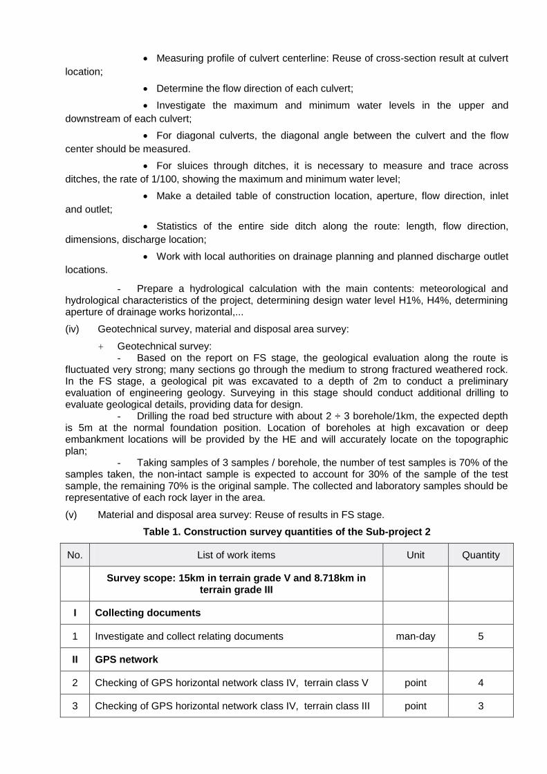
Table 1. Construction survey quantities of the Sub-project 2
No. List of work items Unit Quantity
Survey scope: 15km in terrain grade V and 8.718km in
terrain grade III
I Collecting documents
1 Investigate and collect relating documents man-day 5
II GPS network
2 Checking of GPS horizontal network class IV, terrain class V point 4
3 Checking of GPS horizontal network class IV, terrain class III point 3

No. List of work items Unit Quantity
4 Technical leveling for GPS, terrain class V km 30
5 Technical leveling for GPS, terrain class III km 18.718
6 Checking of Control point network class 2, terrain class V point 25
7 Checking of Control point network class 2, terrain class III point 20
8 Technical leveling for Control point network class 2, terrain class V
km 15
9 Technical leveling for Control point network class 2, terrain class III
km 8.718
III Topographical survey
Main alignment survey
10 Profile on-shore, terrain class V 100m 150
11 Profile on-shore, terrain class III 100m 87.18
12 Cross section on-shore, terrain class V 100m 315
13 Cross section on-shore, terrain class III 100m 183.078
Intersection survey
14 Profile on-shore, terrain class V 100m 10
15 Cross section on-shore, terrain class V 100m 20
Culvert survey
16 Profile on-shore, terrain class V 100m 8
17 Cross section on-shore, terrain class V 100m 16
Bridge survey
18 Profile on-shore, terrain class V 100m 0.8
19 Cross section on-shore, terrain class V 100m 6
IV Hydrological survey
20 Checking and collection hydrological data man-day 5
V Geotechnical investigation
21 Drilling on land, up to 30m, grade I-III m 96
22 Drilling on land, up to 30m, grade IV-VI m 64
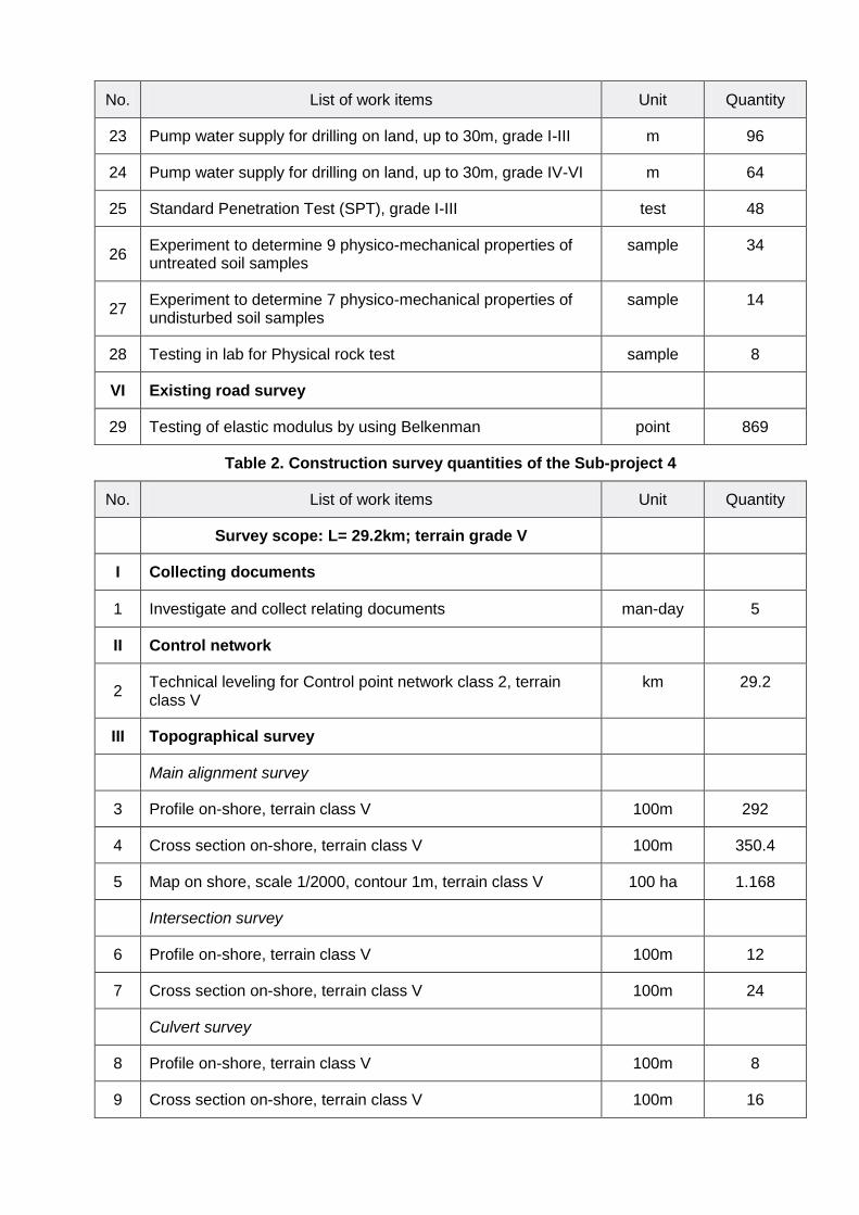
No. List of work items Unit Quantity
23 Pump water supply for drilling on land, up to 30m, grade I-III m 96
24 Pump water supply for drilling on land, up to 30m, grade IV-VI m 64
25 Standard Penetration Test (SPT), grade I-III test 48
26 Experiment to determine 9 physico-mechanical properties of untreated soil samples
sample 34
27 Experiment to determine 7 physico-mechanical properties of undisturbed soil samples
sample 14
28 Testing in lab for Physical rock test sample 8
VI Existing road survey
29 Testing of elastic modulus by using Belkenman point 869
Table 2. Construction survey quantities of the Sub-project 4
No. List of work items Unit Quantity
Survey scope: L= 29.2km; terrain grade V
I Collecting documents
1 Investigate and collect relating documents man-day 5
II Control network
2 Technical leveling for Control point network class 2, terrain class V
km 29.2
III Topographical survey
Main alignment survey
3 Profile on-shore, terrain class V 100m 292
4 Cross section on-shore, terrain class V 100m 350.4
5 Map on shore, scale 1/2000, contour 1m, terrain class V 100 ha 1.168
Intersection survey
6 Profile on-shore, terrain class V 100m 12
7 Cross section on-shore, terrain class V 100m 24
Culvert survey
8 Profile on-shore, terrain class V 100m 8
9 Cross section on-shore, terrain class V 100m 16

No. List of work items Unit Quantity
Bridge survey
10 Profile on-shore, terrain class V 100m 2
11 Cross section on-shore, terrain class V 100m 10
IV Hydrological survey
12 Checking and collection hydrological data man-day 5
V Existing road survey
13 Testing of elastic modulus by using Belkenman point 534
b. Scope of the construction survey works for the Sub-project 6: Pac Mieu domestic water supply system, Bao Lam district, Cao Bang province as describe below:
(i) Network control system:
+ Control point network class 2: Reuse of the system prepared in FS stage. Conducting the review, making additional network if required.
+ Technical leveling control point: The technical leveling mark is set to coincide with the level 2 control points. Using national elevation mark to lead and measure all point in route. By means of a leveling machine, measure by the method using a measuring device to return.
(ii) Topographic survey: Reuse of results in FS stage and make some main additional work as follows:
+ Mapping: - Measuring and drawing the plan of 1/200 scale, the contour line of 0.5m, for the
entire spillway, filter tank, regulating tank, reservoir and hydrological piles of residential areas by total method, average detailed point density from 10 to 40m. In areas with complex topography and terrain, we have to increase the mia points to ensure the accuracy of the plan.
- The content of the plan should display all of the topographic and physical factors, noting as prescribed. Terrain shape is shown by the contour 1m. Symbols used in the map comply with current regulations.
+ Profile measuring: - Steel pipes; - HDPE pipes; - Measure 30-50m each section, when the terrain changes, it is necessary to
increase the density according to the change of the terrain. - Profile scale: Height 1/500; Horizontal 1/200 or Height 1/1000; Horizontal 1/200.
+ Cross-section measuring: - Steel pipes; - HDPE pipes; - Profile scale: Height 1/100; Horizontal 1/100.
(iii) Geotechnical and Hydrological survey: Reuse of results in FS stage.
(iv) Material and disposal area survey: Reuse of results in FS stage.
(v) Land acquisition pegging: Produce, locate and insert LA stake in order to determine the area of structure such as tank, treatment plan.
Table 3. Construction survey quantities of the Sub-project 6
No. List of work items Unit Quantity
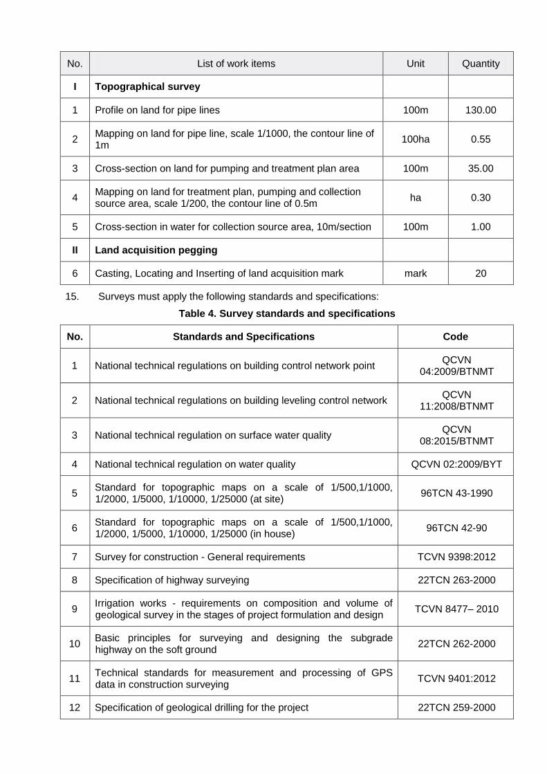
No. List of work items Unit Quantity
I Topographical survey
1 Profile on land for pipe lines 100m 130.00
2 Mapping on land for pipe line, scale 1/1000, the contour line of 1m
100ha 0.55
3 Cross-section on land for pumping and treatment plan area 100m 35.00
4 Mapping on land for treatment plan, pumping and collection source area, scale 1/200, the contour line of 0.5m
ha 0.30
5 Cross-section in water for collection source area, 10m/section 100m 1.00
II Land acquisition pegging
6 Casting, Locating and Inserting of land acquisition mark mark 20
15. Surveys must apply the following standards and specifications:
Table 4. Survey standards and specifications
No. Standards and Specifications Code
1 National technical regulations on building control network point QCVN
04:2009/BTNMT
2 National technical regulations on building leveling control network QCVN
11:2008/BTNMT
3 National technical regulation on surface water quality QCVN
08:2015/BTNMT
4 National technical regulation on water quality QCVN 02:2009/BYT
5 Standard for topographic maps on a scale of 1/500,1/1000, 1/2000, 1/5000, 1/10000, 1/25000 (at site)
96TCN 43-1990
6 Standard for topographic maps on a scale of 1/500,1/1000, 1/2000, 1/5000, 1/10000, 1/25000 (in house)
96TCN 42-90
7 Survey for construction - General requirements TCVN 9398:2012
8 Specification of highway surveying 22TCN 263-2000
9 Irrigation works - requirements on composition and volume of geological survey in the stages of project formulation and design
TCVN 8477– 2010
10 Basic principles for surveying and designing the subgrade highway on the soft ground
22TCN 262-2000
11 Technical standards for measurement and processing of GPS data in construction surveying
TCVN 9401:2012
12 Specification of geological drilling for the project 22TCN 259-2000
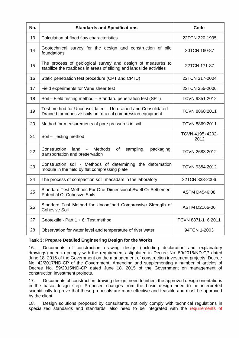
No. Standards and Specifications Code
13 Calculation of flood flow characteristics 22TCN 220-1995
14 Geotechnical survey for the design and construction of pile foundations
20TCN 160-87
15 The process of geological survey and design of measures to stabilize the roadbeds in areas of sliding and landslide activities
22TCN 171-87
16 Static penetration test procedure (CPT and CPTU) 22TCN 317-2004
17 Field experiments for Vane shear test 22TCN 355-2006
18 Soil – Field testing method – Standard penetration test (SPT) TCVN 9351:2012
19 Test method for Unconsolidated – Un-drained and Consolidated – Drained for cohesive soils on tri-axial compression equipment
TCVN 8868:2011
20 Method for measurements of pore pressures in soil TCVN 8869:2011
21 Soil – Testing method TCVN 4195÷4202-
2012
22 Construction land - Methods of sampling, packaging, transportation and preservation
TCVN 2683:2012
23 Construction soil - Methods of determining the deformation module in the field by flat compressing plate
TCVN 9354:2012
24 The process of compaction soil, macadam in the laboratory 22TCN 333-2006
25 Standard Test Methods For One-Dimensional Swell Or Settlement Potential Of Cohesive Soils
ASTM D4546:08
26 Standard Test Method for Unconfined Compressive Strength of Cohesive Soil
ASTM D2166-06
27 Geotextile - Part 1 ÷ 6: Test method TCVN 8871-1÷6:2011
28 Observation for water level and temperature of river water 94TCN 1-2003
Task 3: Prepare Detailed Engineering Design for the Works
16. Documents of construction drawing design (including declaration and explanatory drawings) need to comply with the requirements stipulated in Decree No. 59/2015/ND-CP dated June 18, 2015 of the Government on the management of construction investment projects; Decree No. 42/2017/ND-CP of the Government: Amending and supplementing a number of articles of Decree No. 59/2015/ND-CP dated June 18, 2015 of the Government on management of construction investment projects.
17. Documents of construction drawing design, need to inherit the approved design orientations in the basic design step. Proposed changes from the basic design need to be interpreted scientifically to prove that these proposals are more effective and feasible and must be approved by the client.
18. Design solutions proposed by consultants, not only comply with technical regulations in specialized standards and standards, also need to be integrated with the requirements of

improving traffic safety, enhancing likelihood responding to climate change, minimizing adverse impacts on the environment and other safeguard policies of the project to ensure the achievement of the overall objectives of the Project.
19. The entire expected plan for the construction package needs to be generalized in the document of construction drawing design, showing specific requirements on resources (materials, machines, and personnel), construction time, construction schedule for main items such as roadbed, pavement, bridges, works on the road ... The recommendations of consultants need to consider regional climate conditions of Cao Bang and the specific construction conditions of the work to ensure these proposals are feasible.
20. Risks that may affect the quality of construction, construction progress, labor safety and other social risks (if any) during the construction process also need to be analyzed, and at the same time, recommended preventive measures to ensure that risk factors in the construction phase are always strictly controlled.
21. When preparing Detailed Engineering Design of the required Works, the following standards must be applied:
Table 5. Design standards and specifications
No. Standards and Specifications Code
A Transportation works
1 Design standard for motorway designing TCVN 4054-2005
2 Design standard for bridge designing 22TCN 272 – 05
3 Loads and Effects - Design Standard TCVN 2737-1995
4 National Technical Regulation on Traffic Signs and Signals QCVN
41:2016/BGTVT
5 Geotextiles in embankment construction on soft ground 22TCN 248-1998
6 National technical Regulation on data of natural condition used in construction
QCVN 02:2009/BXD
7 Flexible pavement - standard test method for determination of elastic modulus of pavement structure using Benkelman
TCVN 8867:2011
8 Soft pavement - Determining the elastic modulus of the ground and pavement texture layers by the method of using hard pressed sheets
TCVN 8861:2011
9 Flexible Pavement – Design Requirements and Guidelines 22TCN 211 - 06
10 Rigid pavement - Design standard 22TCN 223-95
11 Temporary regulations on design of ordinary cement concrete pavement with joints in construction of traffic works
Decision No. 3230 / QD-BGTVT dated
December 14, 2012
12 Pile foundation - Specifications for design TCXD 205:1998
13 Pre-stressed concrete anchor T13, T15, D13, D15 22TCN 276-2000
14 Reinforced rubber bearings AASHTO M251-92

No. Standards and Specifications Code
15 Rubber expansion joints AASHTO M297-96
AASHTO M183-96
16 The process of designing bridges and culverts according to the limited state
22TCN 18-79
17 Urban Roads - Specifications for Design TCXDVN 104-2007
18 Procedures for formulation of the building organization design and the building works design
TCVN 4252-1988
19 Design process of temporary works and auxiliary equipment for bridge construction
22 TCN 200-1989
20 Aggregates for concrete and mortar - Sampling and Test methods TCVN 7572-1÷15:2006
21 Building structures and foundations - Basic rules for calculations TCVN 9379 : 2012
22 Steel structure - Design standards TCVN 5575 : 2012
B Electric and Water supply works
23 Specifications for design of foundation for buildings and structures TCVN 9362: 2012
24 Building structures and foundations - Basic rules for calculations TCVN 9379: 2012
25 Protection of structures against lightning - Guide for design, inspection and maintenance
TCVN 9385:2012
26 Installation of electric equipment in dwellings and public building - design standard
TCVN 9206:2012
27 Electric equipment regulations - Part I: general provisions 11 TCN 18: 2006
28 Electric equipment regulations - Part II: system of electric conducive lines
11 TCN 19: 2006
29 Electric equipment regulations - Part III: distribution equipment and transformer stations
11 TCN 20: 2006
30 Electric equipment regulations - Part IV: protection and automation
11 TCN 21: 2006
31 Water Supply - Distribution System and Facilities Design Standard TCXDVN 33-2006
32 And other Standards and Specifications ……….
Task 4: Prepare Cost estimates for the Works
22. The cost estimates for the required works shall be made in accordance with the provisions of Decree No. 32/2015/ND-CP and guiding circulars.
23. Unit prices and construction norms should be updated according to the latest documents and institutions at the time of work execution.
Task 5: Prepare Specification and maintenance procedures for the Works
24. The consultant must prepare those documents in compliance with the regulations on technical guidance and maintenance procedures for works as required in Decree 46/2015/ND-CP on construction quality management.
Task 6: Co-ordinate closely with stakeholders in the implementation process
25. Detailed designs Documents should be reviewed on the basis of compliance with ADB safeguard policies and suitable with the requirements set out in the PAM of the project.
26. Participate with supporting consultant to implement the loans in community consultation during the detailed design phase.
27. In order to ensure the approval process, the consultant should closely coordinate with BIIG1 PMU – Cao Bang subproject and related units to explain and update the changes and adjustments promptly and solve problems arising in the design phase and also in the construction phase.
Task 7: Author's supervision
28. The consultant will perform author supervision of design contractor during construction phase as specified in Article 28 of Decree 46/2015/ND-CP on quality management and maintenance of the construction work including:
(i) Explain and clarify design documents at the request of the Client, supervision consultants and construction contractors;
(ii) Coordinate with the Client when requested to solve problems arising during the construction process, adjust the design in accordance with the actual requirements, reasonably change the design as required by the client;
(iii) Promptly notify the client and propose handling measures when detecting that the construction is not in accordance with the approved design;
(iv) Participate in the acceptance of construction works when required by the Client. In case of detecting ineligible construction items or construction works for acceptance, there must be timely comments in writing to the Client.
F. Reporting Requirements and Time Schedule for Deliverables
29. The Consultants shall report to Cao Bang PMU. All reports shall be reviewed by Loan Implementing Consultant (LIC) before being submitted to the PMU. Expected key deliverables are in the table 6, and shall be prepared in English and Vietnamese, and a soft copy in format acceptable to the Project Owner. The Consultant shall be responsible for report production related costs.
Table 6. Reporting and Deliverables
No. Report Deliverables Schedule Requirement
Language VN Eng.
1 Inception Report 4 4 0.5 month from the signing date
PMU approve by letter
2 Survey report PMU approve by
letter
2.1
Provincial road 206 (Dam Thuy commune, Trung Khanh district) – Ly Van border gate (Ly Quoc commune, Ha Lang district), Cao Bang province
6 6 1.0 month from the signing date
Report for topographic, hydrolic and geological survey
is in accordance to current regulations
No. Report Deliverables Schedule Requirement
2.2
Tinh Tuc - Phan Thanh - Mai Long roads (Nguyen Binh district, Cao Bang province) - Pac Nam (Bac Kan province)
6 6 1.0 month from the signing date
and standards
2.3 Pac Mieu domestic water supply system, Bao Lam district, Cao Bang province
6 6 1.0 month from the signing date
3 Draft of detailed engineering design PMU approve by
letter
3.1
Provincial road 206 (Dam Thuy commune, Trung Khanh district) – Ly Van border gate (Ly Quoc commune, Ha Lang district), Cao Bang province
6 6 2.0 month from the signing date
Including: Statement, drawing, cost
estimation following current regulations
and standards 3.2
Tinh Tuc - Phan Thanh - Mai Long roads (Nguyen Binh district, Cao Bang province) - Pac Nam (Bac Kan province)
6 6 2.0 month from the signing date
3.3 Pac Mieu domestic water supply system, Bao Lam district, Cao Bang province
6 6 2.0 month from the signing date
4 Draft of procurement documents
4.1
Provincial road 206 (Dam Thuy commune, Trung Khanh district) – Ly Van border gate (Ly Quoc commune, Ha Lang district), Cao Bang province
4 4 2.5 month from the signing date
PMU approve by letter
4.2
Tinh Tuc - Phan Thanh - Mai Long roads (Nguyen Binh district, Cao Bang province) - Pac Nam (Bac Kan province)
4 4 2.5 month from the signing date
4.3 Pac Mieu domestic water supply system, Bao Lam district, Cao Bang province
4 4 2.5 month from the signing date
5 Final reports
5.1
Final DED and cost estimation of Provincial road 206 (Dam Thuy commune, Trung Khanh district) – Ly Van border gate (Ly Quoc commune, Ha Lang district), Cao Bang province
8 4 3.0 month from the signing date
DOT approve by decision
5.2 Final DED and cost estimation of Tinh Tuc - Phan Thanh - Mai
8 4 3.0 month from DOT approve by

No. Report Deliverables Schedule Requirement
Long roads (Nguyen Binh district, Cao Bang province) - Pac Nam (Bac Kan province)
the signing date decision
5.3
Final DED and cost estimation of Pac Mieu domestic water supply system, Bao Lam district, Cao Bang province
8 4 3.0 month from the signing date
DOC approve by decision
5.4
Final Procurement document of Provincial road 206 (Dam Thuy commune, Trung Khanh district) – Ly Van border gate (Ly Quoc commune, Ha Lang district), Cao Bang province
8 4 3.0 month from the signing date
DPI approve by decision
5.5
Final Procurement document of Tinh Tuc - Phan Thanh - Mai Long roads (Nguyen Binh district, Cao Bang province) - Pac Nam (Bac Kan province)
8 4 3.0 month from the signing date
DPI approve by decision
5.6
Final Procurement document of Pac Mieu domestic water supply system, Bao Lam district, Cao Bang province
8 4 3.0 month from the signing date
DPI approve by decision
G. Team Composition and Qualification Requirements for the Key Experts
30. The consulting firms will be recruited by Cao Bang PMU in accordance with ADB’s Guidelines on the Use of Consultant (2013, as amended from tim to time) using fixed budget selection (FBS), Biodata Technical Proposal (BTP), lump-sum contract form. Indicative total person months (PM) for Key experts are 44 PMs.
31. Consulting firm should have:
(i) minimum 8 years of experience in conducting survey and design with similar scale and
nature;
(ii) national firms should have valid certificate of survey and design of road works of class III
or higher, international firm should have comparable certificates issued by authorities in the
country of the firm;
(iii) national firms should have valid certificate of survey and design of technical
infrastructure (water supply) class III or higher, international firm should have comparable
certificates issued by authorities in the country of the firm;
(iv) experience in conducting similar assignment under ODA funded projects
(v) geographical experience in North/Northeastern provinces, Vietnam is preferable.
32. Indicative breakdown of PMs for Key experts are shown in the Table 7 below:
Table 7: Indicative team composition
No Experts Nationality Quantity Total Person
month
I Key Experts Vietnam 15 44.0
K-1 Team Leader/ Road Engineer 1 6.0
K-2 Deputy Team Leader/ Water supply
engineer
1 4.0
K-3 Topographic Engineer 1 3.0
K-4 Geotechnical Engineer 1 2.0
K-5 Hydrological Engineer 1 2.0
K-6 Road Engineers 4 12.0
K-7 Bridge/ Structure Engineers 2 6.0
K-8 Water supply Engineer 1 3.0
K-9 Civil Engineer 1 2.0
K-10 Electrical Engineer 1 1.0
K-11 Cost estimates specialist 1 3.0
Note: The list of personnel above is used for reference. Consultants are allowed to mobilize
additional personnel at their own expense to ensure the implementation of the entire amount of
consulting services according to the requirements of FBS and BTP forms.
33. Qualification requirements, assigning tasks of key and non-key experts are given as below:
K-1. Team Leader/ Road Engineer:
Qualification and experience Tasks
Qualifications: University degree in
transport, or related fields; holding the
certificate in transportation works design at
least level II or higher.
Experience: 15-year experience in
transportation designing works; Similar
experience with the position as chief of
transportation design works. Experience in
projects in similar geographic areas
(Northern mountainous region); experience in
ADB/WB funded projects will be an
advantage. Strong communication and
reporting skills. Good health.
- Responsible for the overall content of
the assignment; Coordinate general
activities of the consultant team;
- Participating in the design and
responsible for technical management of
road works;
- Working with the PPMU and other
stakeholders during the implementation
of the assignment and during
construction phase.
K-2. Deputy Team Leader/ Water supply Engineer:
Qualification and experience Tasks
Qualifications: University degree in water
supply, or related fields; holding the
certificate in designing water supply works at
least level II or higher.
Experience: 15-year experience in
designing water supply work. Similar
experience with the position as chief design
of water supply works; Experience in projects
in similar geographic areas (Northern
mountainous region); experience in ADB/WB
- Participate in the design and responsible
for technical management of water
supply works;
- Working with the Client and related
parties during the implementation of the
assignment and during construction
phase.

funded projects will be an advantage. Strong
communication and reporting skills. Good
health.
K-3. Topographic Engineer:
Qualification and experience Tasks
Qualifications: University degree
specialized in geodetic, geology works,
transport/technical infrastructure works, civil
& industrial construction or equivalent;
holding the certificate of topographic survey
at least level II or higher.
Experience: 10-year experience in survey.
Similar experience with the position as chief
surveyor; Experience in projects in similar
geographic areas (Northern mountainous
region); experience in ADB/WB funded
projects will be an advantage. Strong
communication and reporting skills. Good
health.
- Operate the overall survey work;
- Quality control of survey reports;
- Working with related parties during the
survey process.
K-4. Geotechnical Engineer:
Qualification and experience Tasks
Qualifications: University degree
specialized in geotechnical works,
transport/technical infrastructure works, civil
& industrial construction or equivalent;
holding the certificate of geological survey at
least level II or higher.
Experience: 10-year experience in survey.
Similar experience with the position as chief
surveyor; Experience in projects in similar
geographic areas (Northern mountainous
region); experience in ADB/WB funded
projects will be an advantage. Strong
communication and reporting skills. Good
health.
- Operate the overall survey work;
- Quality control of survey reports;
- Working with related parties during the
survey process.
K-5. Hydrological Engineer:
Qualification and experience Tasks
Qualifications: University degree in
construction, environment or equivalent;
holding the certificate of Hydrological survey
at least level II or higher.
Experience: 10-year experience in survey.
Similar experience with the position as chief
surveyor; Experience in projects in similar
geographic areas (Northern mountainous
- Participate in Hydrological survey;
- Quality control of Hydrological survey
report
- Responsible for integrating the result of
hydrological calculations with
consideration of climate change
adaptation;
region); experience in ADB/WB funded
projects will be an advantage. Strong
communication and reporting skills. Good
health.
- Working closely with LIC’s
environmental experts during the
implementation process.
K-6. Road Engineer
Qualification and experience Tasks
Qualifications: University degree in
transportation, or equivalent. Holding the
certificate of road construction design at least
level II or higher.
Experience: 10-year experience in road
construction design; Similar experience with
the position as road engineer; Experience in
projects in similar geographic areas
(Northern mountainous region); experience in
ADB/WB funded projects will be an
advantage. Strong communication and
reporting skills. Good health.
- Operating related road and construction
design work;
- Take responsible to the Team Leader on
the progress of the items quality under
his/her responsibility.
K-7. Bridge/ Structure Engineer
Qualification and experience Tasks
Qualifications: University degree in
transportation, or equivalent. Holding the
certificate of road construction design at least
level II or higher.
Experience: 10-year experience in bridge /
structure construction design; Similar
experience with the position as bridge /
structure engineer; Experience in projects in
similar geographic areas (Northern
mountainous region); experience in ADB/WB
funded projects will be an advantage. Strong
communication and reporting skills. Good
health.
- Operating related bridge / structure
construction design work;
- Take responsible to the Team Leader on
the progress of the items quality under
his/her responsibility.
K-8. Water supply Engineer
Qualification and experience Tasks
Qualifications: University degree
specialized in water supply and drainage.
Holding the certificate of water supply works
at least level II or higher.
Experience: 10-year experience in
designing clean water supply works; Similar
experience with the position as chief water
supply design; Experience in projects in
similar geographic areas (Northern
mountainous region); experience in ADB/WB
- Operating related water supply works;
- Take responsible to the Team Leader on
the progress of the items quality under
his/her responsibility.
funded projects will be an advantage. Strong
communication and reporting skills. Good
health.
K-9. Civil Engineer
Qualification and experience Tasks
Qualifications: University degree
specialized in civil engineering. Holding the
certificate of civil works design at least level II
or higher.
Experience: 10-year experience in
designing structure for clean water supply
works; Similar experience with the position
as chief civil design; Experience in projects in
similar geographic areas (Northern
mountainous region); experience in ADB/WB
funded projects will be an advantage. Strong
communication and reporting skills. Good
health.
- Work related water supply works;
- Take responsible to the Team Leader on
the progress of the items quality under
his/her responsibility.
K-10. Electrical Engineer
Qualification and experience Tasks
Qualifications: University degree
specialized in civil engineering. Holding the
certificate of electrical works design at least
level II or higher;
Experience: 10-year experience in
designing electric for clean water supply
works; Similar experience with the position
as chief electrical design; Experience in
projects in similar geographic areas
(Northern mountainous region); experience in
ADB/WB funded projects will be an
advantage. Strong communication and
reporting skills. Good health.
- Work related water supply works;
- Take responsible to the Team Leader on
the progress of the items quality under
his/her responsibility.
K-11. Cost Estimates Specialist
Qualification and experience Tasks
Qualifications: University degree
specialized in construction economics or
equivalent; holding the certificate of valuation
at least level II or higher;
Experience: 15-year experience in making
cost estimates, total investment for
construction investment projects; Experience
in similar position; Experience in projects in
similar geographic areas (Northern
mountainous region); experience in ADB/WB
- Responsible for construction cost
estimates;
- Take responsible to the Team Leader on
the progress of the items quality under
his/her responsibility.

funded projects will be an advantage. Strong
communication and reporting skills. Good
health.
Non-Key Experts
Qualification and experience Tasks
Qualifications: Specialized university
degree in accordance with assigned position;
Experience: At least 5 years of experience
working in the assigned areas;
Experience in projects in similar geographic
areas (Northern mountainous region);
experience in ADB/WB funded projects will
be an advantage. Strong communication and
reporting skills. Good health.
Assigned by Team Leader to complete the
assignment.
H. Client’s Input and Counterpart Personnel
34. Services, facilities and property to be made available to the Consultant by the Client: For all project-related meetings that will be held in Cao Bang PMU office: Facilities of Cao Bang PMU will be utilized.
35. Professional and support counterpart personnel to be assigned by the Client to the Consultant’s team: N/A
K. Client will provide the following inputs, project data and reports to facilitate preparation
of the Proposals:
- The Consultant documents (PPTA report, Basic design) and other necessary information to perform the service;
- Support to the Consultant for obtaining permits and related documents in accessing and entering the project area.