penobscot river - conservation gateway
TRANSCRIPT

Penobscot River Active River Area Pilot Project: Aquatic Conservation Blueprint
Daniel Kusnierz, Water Resources Program Manager Binke Wang, GIS Coordinator
Penobscot Indian Nation
Joshua Royte, Conservation Planner The Nature Conservancy in Maine

Penobscot Active River Area Project
2
Project Overview The Maine Chapter of The Nature Conservancy and the Penobscot Indian Nation entered into a joint partnership to develop a prototype aquatic conservation blueprint in conjunction with partners using the newly developed Active River Area framework. Out pilot project focuses on key sub-basins (see figure above) of the Penobscot River watershed that will benefit most from the Penobscot River Restoration Project. The goal of the Penobscot River Active River Area Pilot Project is to: 1) develop an aquatic conservation blueprint to highlight priority aquatic systems and the adjoining lands that support healthy river processes to guide more effective conservation and restoration; 2) to bring partners together in building this blueprint to increasing mutual awareness of stream processes and to leverage the prioritization process more broadly. This project will help focus conservation efforts associated with the Penobscot River Restoration Project, a large-scale restoration project that entails the removal of two main-stem hydropower dams and creation of a naturalistic fish bypass on the third. The restoration project is one of the most ambitious and ecologically significant projects in the country for migratory fish such as the endangered shortnose sturgeon, Atlantic salmon and 10 other species. The river and its restoration are also intricately connected to the ecological, spiritual, and economic health of the Penobscot Indian Nation who have lived with and depended upon the river for the past ten thousand years. The Conservancy provided $30,000 in grant funding to the Penobscot Indian Nation to support their work on this project. Key Project Objective The objectives of this project include 1) the development of an up to date aquatic biodiversity dataset, 2) a prioritization methodology, 3) a set of strategies vetted with a body of expertise, and partnerships for future implementation, and 4) the actual prototype Conservation Blueprint on behalf of freshwater in series of significant Penobscot River watersheds. The conservation blueprint allows us and partners to focus limited resources on the most strategic part of watersheds for targeted protection or restoration activities in a way that supports the natural physical, chemical, biological, and ecological processes needed for healthy, adaptive rivers and streams. Summary of Methods/Process The Penobscot River watershed is the largest in Maine covering ¼ of the state (5.5 M acres). To parse out a subset of that as a Pilot project we focused on the portions of the watershed that would most benefit from the Penobscot River Restoration Project (see study area map on Cover Page). Once the study area was defined and then delineated, the team attended a series of WebEx Meetings to learn from TNC regional staff about the GIS methods and tools used to develop the ARA base-layers and some of the ways the data could be used to prioritize areas for biodiversity protection and river restoration.

Penobscot Active River Area Project
3
The Active River Area conservation framework provides a conceptual and spatially explicit basis for the assessment, protection, management, and restoration of freshwater and riparian ecosystems. The active river area framework is based upon dominant processes and disturbance regimes to identify areas within which important physical and ecological processes of the river or stream occur. The framework identifies five key subcomponents of the active river area: 1) material contribution zones, 2) meander belts, 3) riparian wetlands, 4) floodplains and 5) terraces. These areas are defined by the major physical and ecological processes associated and explained in the context of the continuum from the upper, mid and lower watershed in the ARA framework paper (Smith et al. 2008). The framework provides a spatially explicit manner for accommodating the natural ranges of variability to system hydrology, sediment transport, processing and transport of organic materials, and key biotic interactions
Arlene Olivero, TNC Eastern Science
The ARA grid layer was developed by TNC Eastern Conservation Science Office and plotted on a series of large maps by our GIS expert before conducted both in-house and in-field reviews to parts of the Piscataquis and Passadumkeag basins to ground truth ARA components and see how they map out. We then began to compile a library of information and GIS data layers collected from the literature, State of Maine GIS Library, TNC and partner agencies databases, and some algorithms developed by partner groups that we could use to relate data layers to known and potential species habitat. Note: The ARA model at this time has only been applied at 1:100,000 scale. Therefore, we did not include intermittent streams which show up at the 1:24,000 scale. An extensive list of GIS data layers were compiled and further developed (See Appendix C) with help from partners to help fill data gaps and extend point locations to logical habitat polygons. Frequent revisions were made with the specialists to filter the large number of species and species occurrences (sites) to define the highest priority areas. Project partners were identified who had expertise in local and migratory fish, freshwater mussels and aquatic insects, plants, vertebrate animals, aquatic resource management, natural resource conservation, habitat protection, state planners, and other outreach programs. Partner Engagement To increase the quality and validity of our pilot project and to leverage broader usage of the resultant tool we would develop, we engaged over 39 staff members from the Tribe, federal and state agencies and non-governmental organizations joined one or a series of meetings to help us develop the data and tools for the development of the project. Many of these partners serve on other aquatic and conservation related workgroups and bring their collective knowledge to our project. Our interaction with these partners ranged from one-on-one expert interviews with follow-up feedback, dozens of emails and data exchanges small and large staff meeting workshops, dozens of core working group meetings, and two full day Partner Workshops.

Penobscot Active River Area Project
4
Expert meetings were held in advance of larger partner meetings to help us develop better data sets and maps using their data, making our time together more efficient. The two large partner meetings were held to familiarize people with the ARA model and solicit input regarding 1) their interest in the model, 2) data available for prioritization and how it could be used in conjunction with the ARA, for their own future use; 2) to learn about additional potential partners; 3) how optimize existing data for our use; 4) to identify potential strategies for protecting or restoring priority areas; and 6) to further develop a group of partners that could assist with the development of the aquatic conservation blueprint and take the concepts and models beyond the pilot project state. The full list of partner meetings and their participants is listed in Appendix A below. Design Criteria and Process Through the above workshops we identified the following important design criteria for developing our aquatic conservation blueprint for the pilot study area: • Rare plant populations • Rare animal populations with special focus on:
o Rare freshwater mussels and stream segments with multiple species. This is particularly important as the Penobscot has the most habitat for the rarest mussels in addition to hosting the full suite of Maine’s mussel diversity.
o Rare dragonflies, damselflies, butterflies, mayflies, snails o Rare and declining turtles o Rare bird habitat (least bittern, rusty blackbird, black tern)
• Exemplary natural communities: riverine and riparian wetland communities • Include Beginning with Habitat “Focus Areas” – those areas already identified as
significant because of the overlap of rare species, communities, and state-significant wildlife habitat (waterfowl habitat, deer wintering) and part of Maine’s Wildlife Action Plan
• Key Tribal resources areas (floodplain foraging, medicinal, and recreational areas) • Guidance to help prioritize among significant individual features and combinations
(e.g. the importance of sites with many rare species in one area, as well as a streams with no other fish (including invasives) besides brook trout)
• Guidance to select the up and downstream ARA components where they supports healthy stream function for species habitat (e.g. contribution or meander belt)
• Stream connectivity: aquatic habitats that are not obstructed by dams and other barriers will support more viable, adaptive biota (TNC Barrier Assessment Tool)
• Areas with acid buffering capacity (calcareous substrate) • Areas with high potential for coldwater discharges supporting summer refugia
(aquifer or coarse sediment) • Stream networks with high density of salmon producing habitat • Stream networks with high quantity Eastern Brook trout habitat
Penobscot Active River Area Project
5
The following processes were developed for selecting Priority Areas to derive the conservation blueprint: • Prioritize biota to map based on global and state rarity and affinity to rivers (see
details in Appendix B) • Map priority sites for above based on supporting riverine and/or riparian habitat
that capture areas with the most vital populations of one or overlapping target species
• The Active River Area up and downstream of key species habitat were evaluated for the potential to support a) additional habitat because of similar in-stream or riparian habitat based on ARA, landform or surficial geology (ELU), or NWI wetlands classification or b) support river function that would be critical for species life stages (e.g. sandy banks for turtle nesting, floodplains with sedge meadows for Tomah mayfly spawning).
• Extend upstream when tributaries likely support critical downstream habitats as well as newly mapped Atlantic salmon productive areas and mapped productive Eastern Brook Trout habitat (use headwater HUC 12 watersheds)
• Calcium-rich bedrock: tributaries draining lands with calcium-rich bedrock (ELU Grid) were weighted more heavily for inclusion when there were key proximal or downstream habitats for Atlantic salmon, brook trout, mussel, and “calcium-loving” plants and animals (e.g. Clayton’s copper butterfly feeds on shrubby cinquefoil a known calciphilic shrub)
• Cold-water discharge: tributaries was ranked higher for inclusion when it overlapped or flanking glacial sand and gravel outwash deposits (ELU Grid) and aquifers (MEGIS)
Rationale: Ground water emanating from areas with calcareous bedrock have a higher likelihood of buffering stream pH against ongoing acidification. Acidification has been blamed for developmental problems especially in young salmon. Areas with glacial outwash deposits are more likely to discharge cold water, which is a limiting factor for salmon and trout among other species during warmer climatic periods. Both geologic components are likely to be critical for species persistence as climate change increases stress on aquatic organisms already stressed by warming water, blocked access to cold-water refugia and developmental barriers.
Penobscot Active River Area Project
6
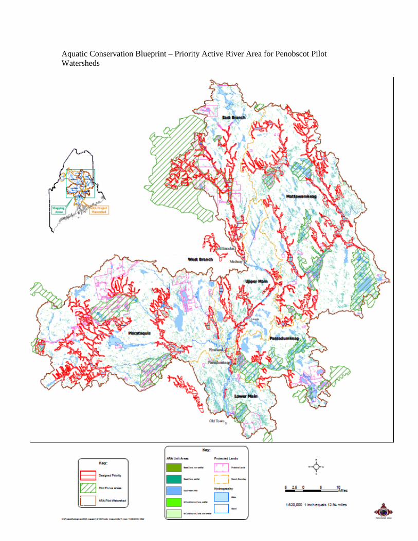
Results: Current Iteration of the Aquatic Conservation Blueprint – Priority ARA Areas The Aquatic Conservation Blueprint consists of a data layer (See ARA Priority Area Maps in attached PDF maps formatted for 2x3 feet and sample pullout detail map below)
• The Active River Area covers 28% of the Pilot Project landmass (in all cases
below, excludes lakes, ponds or rivers (4% of the watershed is mapped as open water). This part of the state is known to have very extensive wetlands.
• The Priority ARA areas cover 9% of the entire Pilot Project watersheds and which is 28% of the mapped ARA lands
• 20% of the ARA Priorities are included in existing Focus Areas • 10% of the ARA Priorities are already in Protected Lands (Gap 123) half of that in
ecological reserve (GAP 12) We found algorithms could be developed to include clusters of priority habitats and their supporting ARA landscapes, however, in the end it was critical for biologists/ecologists to delineate more logical designs that took into account the juxtaposition of critical habitats with the surrounding river and tributary configuration and the contributing watershed’s geology and ARA context. A series of steps will be taken over the coming months to streamline this process, some that may be automated, but most will require guidance from ecologists to determine Priority Area boundaries:
• Develop algorithms to exclude extensive peatlands and forested wetlands that are minimally affected/ distant from river processes and are under very minimal threat of alteration –many place-based decisions will probably be needed.
• clip out upland inclusions and broad non-floodplain wetlands (like some above bullet) >1,000 feet from the stream corridor
• Consider pond side and downstream biota when determining whether or not in to include lakes and ponds in the Priority ARA
Penobscot Active River Area Project
7
Aquatic Conservation Blueprint – Priority Active River Area for Penobscot Pilot Watersheds

Penobscot Active River Area Project
8
Detail of section of the 2’ x 3’ Blueprint with highlighted geologic and biological features that were used to delineate the Priority Area in dark purple outline.

Penobscot Active River Area Project
9
Strategies and actions for specific priority mapped areas Our large and small workshops and presentation spurred a great deal of interest in using the Active River Area base layer and for developing a broader prioritization process for use throughout the Penobscot River watershed and likely within a year Statewide. Potential uses that arose from our meetings with partner groups include: Penobscot Indian Nation:
• Review/revise riparian protection on tribal lands tied to stream processes. • Tribal Historic preservation office can determine whether these areas have
significant cultural importance. • Environmental review and site advocacy • Stream water quality sampling design • Restoration potential for floodplain in conjunction with NRCS
Maine Aquatic Connectivity Workgroup: Will use the ARA and prioritization model to help prioritize the highest value stream segments to restore connectivity to through barriers mitigation to restore flow and fish passage Maine Beginning with Habitat Program (Wildlife Action Plan): to improve the current aquatic protection recommendations which currently are uniform buffers statewide Maine Department of Environmental Protection: Stream and Lake Assessment: Prioritization for water quality protection (e.g. on impaired waters from non-point source and historic channel impairment) Maine Inland Fisheries and Wildlife: Further development of model for species habitat mapping
Maine Land Use Regulation Commission (LURC) has jurisdiction over half of Maine within the Unorganized Townships (UT). LURC is interested in the prioritization for;
• Transmission Line siting and vegetation management design for those areas it crosses,
• Application of the State Stream buffer rules in the UT, • Implementation Planning for LURC’s Comprehensive Land Use Plat (CLUP) –
much more Bang for the Buck than working on the CLUP itself. • The Location of Development Plan, • Guidance for State’s River Management Plans (there are only three now, but
could/should be more, TNC leadership could help since we are party to the St. John Plan and it’s up for renewal), and
• Working with FSC certifiers for increased aquatic protection • Plum Creek Management Committee (talk with Al Hutchinson)

Penobscot Active River Area Project
10
Regional Conservation Blueprint Efforts Provided with Base Layer • South-central Maine’s Lake Region Blueprint • Kennebec Regional Land Trust Conservation Blueprint
Next Steps for Aquatic Conservation Prioritization There has been sufficient interest and use of these data and this process for a number of partners to join in the further development of the methods and the aquatic conservation blueprint maps and application to a broader geographic area. The Nature Conservancy and the Penobscot Indian Nation will continue to work with partners to develop the ARA with our “blueprinting” tools to better map and prioritize among conservation target and supporting landscape features for protection and restoration projects. Action Steps:
• Provide Pilot Project outcome review in WebEx or live meeting format for all of the partners and additional partners that were recommended but not available
• Provide species experts a chance to review QA/QC the data layers derived from their data and help to correct and improve upon them
• Develop a Results Chain (i.e. in Miradi) to show assumptions between aquatic objectives and land protection and restoration strategies. Use ranking system to sort among this large list of actions to determine best return on investment.
• Work with IF&W and MNAP biologists and GIS managers to develop species habitat areas with greater consideration of ARA components that support species habitat for a diversity of life stages and consider ways to use GIS tools to better map existing population locations and predict new ones (e.g. floodplain overlap with sedge meadows for Tomah mayfly, Calcareous bedrock overlap with stream shore wet-flat sedge and shrub meadows for Clayton’s copper,
• Test ARA Priority areas along mapped outwash deposits and aquifers for cold-water discharge areas – how well are they predicted.
• Meet with state geologists to evaluate bedrock fracture areas that might predictably yield cold-water discharges
• Develop attribute tables for ARA Priority Area segments so there is point and click transparency of why specific stream reaches were selected and where the most efficient protection or restoration strategies might be applied
• Develop new more comprehensive ARA layer for Maine using the upcoming 1:24,000 scale NHD+ data layer and reapply the prioritization process to this new base data layer.
• Expand the prioritization system to the larger suite of rare species and exemplary natural communities that occur outside of the pilot project watersheds in Maine.

Penobscot Active River Area Project
11
• Work with the BwH steering committee to determine feasibility of using this data layer and prioritization models in a way consistent with the methods developed for existing Focus Areas and potentially modify and develop new Focus Areas that feature aquatic conservation targets not already included in their methods.
• Work with State Beginning with Habitat Steering Committee to improve the way aquatic systems protections are referenced in the online Tool Box.
• Calculate the acreage of productive forest lands in priority ARA areas for a set of ownerships starting with TNC and PIN lands, then move to friendly industrial forest managers land to calculate real-world costs of potential protection strategies such as larger and no-cut buffers, improved stream passage, floodplain restoration, etc..
• Compare ARA Priority design with existing broad (250, 500, and 1,000-foot) buffers protected on portions of some of Maine’s large rivers (e.g. St. John, Machias, W. Branch Penobscot, Moose, and Allagash Rivers).
• Identify potential restoration projects eligible for USDA Farm Bill restoration and protection funding with WHIP funds.
Conclusion: In Maine the Active River Area model and our prioritization system provides PIN, TNC and multiple state, federal and NGO partners new tools to recognize in a spatially explicit way, lands that are critical for the proper functioning of riverine processes and a process for prioritizing among them for the sake of aquatic biodiversity and cultural values. This is extremely valuable for making a quantum leap in our mapping and prioritization of biologically important habitats just as a number of state-wide and region-wide programs are developing mapping and prioritization tools to guide conservation for freshwater biodiversity. We look forward to improving this prototype and expanding to larger scales.
Penobscot Active River Area Project
12
APPENDIX A: Penobscot River Active River Area Pilot Project Meetings
• Active River Area Project Core Work Group (Regular meetings, check –in calls, and WebEx meetings between August 2009 and project completion in November 2010) • The Nature Conservancy in Maine • Penobscot Indian Nation (GIS Program and Water Resources Program)
• Maine Department of Inland Fisheries and Wildlife (ME DIFW) Bangor Office: full staff presentation Q&A (4/14/10)
• ME DIFW Bangor Office: Aquatic species biologists workshop (4/14/10) • Full Day Partner Workshop (5/13/10) with representatives from
o United States Fish and Wildlife Service (USFWS) o National Oceanic and Atmospheric Administration (NOAA) – National Marine
Fisheries Service (NMFS) o United States Department of Agriculture (USDA) – Natural Resource
Conservation Service (NRCS) o United States Geological Service (USGS) o ME DIFW o Maine Department of Marine Resources, Bureau of Searun Fish (DMR) o Maine Department of Conservation - Maine Natural Areas Program (MNAP) and
Maine Forest Service (MFS) o Maine Department of Environmental Protection (ME DEP) o Maine State Planning Office (SPO) –Maine Coastal Program o Eastern Brook Trout Joint Venture (EBTJV) o Maine Beginning with Habitat Program o Forest Society of Maine o Penobscot Indian Nation (Forestry Program and Tribal Historic Preservation
Office) o The Nature Conservancy (Community and Government Outreach staff)
• Maine Land Use Regulatory Commission (LURC) Workshop (6/8/10) with all staff planners
• The Nature Conservancy of Maine Strategic Planning Team (7/14/10) • Beginning with Habitat Steering Committee (10/14/10)
o MNAP o IF&W o Maine Audubon o SPO o TNC o ME DEP o Maine Department of Transportation (MDOT)
• Active River Area Blueprint Prioritization Workshop (11/8/10) o The Nature Conservancy o Penobscot Indian Nation o USFWS

Penobscot Active River Area Project
13
o Maine DEP o MNAP
Also Independent Blueprint Design Reviews done by IF&W rare species group, EBTJV, MNAP, MDMR, and USFWS – additional partners will join in as the project extends to broader landscapes List of Penobscot River ARA Pilot Project Participants Aga Pinnette, LURC Alex Abbott, USFWS Alex Mas, TNC, Strategic Partnerships Andy Cutko, MNAP Barbara Vickery, TNC Beth Swartz, IF&W Bethany Atkins, BwH Binke Wang, PIN Bonnie Newsom, PIN Dan Kusnierz, PIN Dan Schmidt, NRCS Dave Courtemanch, Maine DEP Ellen Jackson, LURC Gordon Moore, Maine Forest Service Jed Wright, USFWS Jeff Norment, NRCS Joan Trial, DMR Jonathan Mays, IF&W Joshua Royte, TNC Judy Gates, MDOT Keith Kanoti, Maine Forest Service Liz Hertz, SPO
Marcia Spencer-Famous, LURC Mark Whiting, DEP Merry Gallagher, EBTJV & IF&W Molly Dougherty, MNAP Nels Kramer, IF&W Peter McKinley, Forest Society of Maine Phillip DeMaynadier, IF&W Richard Dill, DMR Rob Dudley, USGS Russ Roy, PIN Sally Stockwell, Maine Audubon Society Samantha Horn-Olsen, LURC Sarah Giffen, LURC Shonene Scott, MNAP Slade Moore, SPO Coastal Program Steve Walker, BwH Sue Burns, LURC Tara King, NRCS Tara Trinko, NOAA Tim Beaucage, LURC
Tom Abello, TNC Gov’t Relations

Penobscot Active River Area Project
14
APPENDIX B: Criteria for filtering and selection of rare species sites for Aquatic Priority Area inclusion Existing species and natural community polygons, points, and arcs were used in conjunction with the ARA base-layer to delineated swaths of river and stream shores and key tributary networks vital to sustaining and recovering this biodiversity. The initial sort was freshwater mussel data to identify priority sites
• In the Pilot Project watersheds there are 225 records where Maine’s 4 rare mussel species occur, these fall into roughly in 92 sites (distinct SiteName, by Drainage Number by township)
• Maine has 10 mussel species. All occur in the Penobscot River basin and overall it is the best watershed for mussel diversity and abundance – thus a little extra attention
• Of the 92 sites, 55 have rare species as well as at least 4 other rare or non-rare species (total of 5). We did check sites with 4 or fewer species to ensure we didn’t miss any critical sites that had >1 of the rarer three of the four species.
• The richer sites were mapped including Active River Area grid cells up and downstream with an emphasis on tributaries that entered nearby upstream that drained watersheds with calcareous bedrock or overlap with other priority species (e.g. concentrations of salmon spawning or rearing habitat, connected networks of brook trout streams especially if those streams are flanked by sand and gravel aquifer areas – potential cold water discharge areas)
We then looked at other RTE Animals: • TNC has 275 records in the Pilot Area (of 2081 statewide) • 143 records after excluding mussels • 140 records after excluding Globally common (G5) AND State Status = SC (special
concern, so keeping other State Threatened or Endangered) • 78 records after excluding non-freshwater-associated species (peregrine falcon,
Katahdin arctic, Northern Bog lemming, upland sandpiper and also chose to exclude bald eagle, black crown night heron
• We compared these to existing BwH Focus Areas. 50 sites fall outside of BwH Focus Areas in roughly 39 sites. New “Priority Aquatic Areas” were mapped or dropped based on the following criteria; 1) The site was dropped if surrounded by development (e.g. several turtle sites from
roads surrounded by development, gravels pits) 2) The site was dropped if the species occurrence was completely isolated from
streams with other freshwater values (e.g. in an isolated bog) or stream stretch hemmed in by dams and no other habitat values overlapping.
3) Sites were added and delineated by proximity to similar habitat type such as extending a Priority Aquatic Area up and/or downstream from an occurrence to include salmon spawning/rearing habitat, multi-branched networks of verified brook trout streams
a. NWI wetlands (e.g. emergent floodplain marshes for Tomah mayfly based on ARA LANSAT flooded extend & NWI wetlands)
b. Aerial photographs (2009 NAIP), c. flanking deposits of sand and gravel derived from surficial geology (TNC-
ELU) data – e.g. for turtles

Penobscot Active River Area Project
15
d. upstream tributaries and stream-shore areas underlain with calcareous or somewhat calcareous bedrock (TNC-ELU)
Atlantic salmon habitat maps were queried to capture additional important salmon habitat by extending ARA Aquatic Priority Area polygons to the extent of the HUC 12 boundary where highly productive salmon spawning and rearing habitat was mapped unless
- if a lake intersects the habitat then we ended the priority area polygon at the downstream extent of the lake.
- if a known natural barrier to salmon exists the priority area boundary ends at the barrier.
Developing the Active River Area Priority Area Polygons Steps to create the layer of Priority Areas
1. From ARA grid to ARA shapefiles: a base ARA unit source layer is a grid created by Arlene Olivero to make the next steps easier the ARA is converted to a shapefile
2. ARA units dissolve: The original ARA unit layer has 5 types of polygons that were dissolved into a one-type polygon layer
3. The grid-based ARA polygon boundary are mostly zigzag due to its grid origin. We used the ArcMap “Smooth Line” tool smoothed with 100 meter tolerance to eliminate this jagged edge.
4. Tiny polygon elimination: The above polygon layer contained hundreds of small and isolated tiny polygons. The ArcMap “Eliminate” command was used to remove that “noise”. The elimination threshold here is 1 million square meters or 247 acres, which is smaller than the minimum polygon in the Draft Priority Area layer created.
5. Initial Priority Area layer creation: The ARA unit layer supported a basic raw graphic source to make a primary priority area layer. The first step is to use the Draft Priority polygons created by biologists as a template, cut/split the raw ARA source polygons which matched or intersected the draft-priority polygons. For additional areas with priority habitat overlap, those overlapping habitat features were digitized using the new ARA boundary. This included a final sort of top 10% of the watersheds and stream networks for Atlantic salmon and Eastern Brook trout as developed by species expert groups. Cut/split/merge complete Priority Area layer using polygons of priority areas developed and edited with input from Workshop Participants (Royte, Wright, Gallagher, Trial, Walker, & Cutko)
Quality Control Review from Species Experts was sought out from several salmon experts (Jed Wright, USFWS, Tara Trinko NOAA, Joan Trial, MDMR) and the state’s lead for the Eastern Brook Trout Joint Venture (Merry Gallagher) to verify the model captured at least the top ~25% priority habitat in the project areas for Atlantic salmon and wild Eastern Brook Trout.

Penobscot Active River Area Project
16
Appendix C: Data Layers and Sources Used
• Active River Area Priority Areas – Developed by Binke Wang for this project • Active River Area - Developed by Arlene Olivero, TNC Eastern Region Science • Penobscot Floodplain LANDSAT Analysis – Arlene Olivero • Priority Atlantic Salmon Production Areas – Jed Wright, USFWS based on
assessments from the USFWS and NOAA NMF • Salmon spawning and rearing habitat – USFWS with NOAA • Rare Plants and Exemplary Natural Communities [EO_Reps] – MNAP; with
derivative layers through filtering by Josh Royte, TNC • Rare Animal Sites [IF&W] – with J. Royte derivative layers • Rare Freshwater Mussel Survey Data – Beth Swartz, IF&W sorted and filtered
by Josh Royte • Wild Brook Trout Habitat 2010 – Merry Gallagher, IF&W & EBTJV • Alewife Priority Ponds – Tier I restoration ponds from DMR • Beginning with Habitat Focus Areas – State Wildlife Action Plan Sites from
the BwH Steering Committee implemented by MNAP 2010 • Penobscot Stream Crossing Survey – Alex Abbott and Jed Wright – USFWS • Waterfalls – USFWS, DMR, IF&W and TNC 2010 Regional Prioritization • Functional River Network – Barrier Assessment Tool output from Erik Martin
under TNC Eastern Region • Dams – Maine GIS data developed by TNC Eastern Region • 1:24k and 1:100k National Hydrology Layer Streams and Ponds – MEGIS from
USGS? • Lakes Base Layer – MEGIS Ponds and Lakes • National Hydrologic Unit Code Watersheds - HUC12, HUC8 for ARA and
salmon, trout, and mussel selection areas • Roads - Maine DOT • Conservation Ownership – Dan Coker, TNC Maine • Landownership – J. M. Sewall Company by permission through TNC and PIN • Maine Vegetation Classification – GAP Landcover - MEGIS • Ecological Landscape Units for bedrock and surficial geology by Mark
Anderson and Charles Ferree, TNC Eastern Region Science • Maine Aquifers – MEGIS with above for groundwater pH and Temperature
influence on priority habitats • National Wetland Inventory – statewide classified wetland coverage for
species habitat delineation and ARA overlap • Seamless Topographic map - NGS_Topo_US_2D, ArcGIS Online.com

Penobscot Active River Area Project
17
Appendix D: The world of values that could be mapped in conjunction with Active River Area model to develop Aquatic Conservation Blueprint: Draft: 8-24-09
• Cultural values of Penobscot Indian Nation – Bonnie and SHPO o Archaeological sites – Not Public o Historical sites – Potential, but will need a great deal of work o Tribal lands (Trust and Fee Lands) – PIN database o Other tribal lands – Sewall Database o Other culturally significant areas? – probably not identify any values (e.g.
would not want to see a map showing important deer, moose, muskrat, other fur-bearers, fiddlehead, birch bark, brown ash, medicinal plant areas – these are culturally sensitive, and mostly unmapped, may show area without a public label or identifier, just as “Culturally Important Area?
• Water-oriented Recreation o Boat landings – state landings (MEGIS) o Swimming holes – when identified o Popular rafting, kayaking, canoeing trips – when identified
• Beginning with Habitat Data - TNC has it o Rare, threatened, endangered species o Exemplary natural communities o Significant Wildlife Habitats
• Water Quality Limitations - Tribe has o State Classification o Special consumption advisory areas (not statewide advisories i.e. Hg) o Non-attainment areas (e.g. not attaining DO criteria)
• Active River Area Components o Floodplain – rough model for now o Terraces – rough based on DEM; kame terraces and eskers for cold water o Riparian wetlands - NWI o Meander belt - Modeled o Material contribution areas – Everywhere need to prioritize
• Migratory fish habitat – Have some o Dams with and w/o fish passage o Areas accessible with 3 or fewer dams (post PRRT project) o Connected stream networks (without dams or restrictive culverts) o Connected ponds (without dams or restrictive culverts) o Natural barriers – have some
• Heritage Brook trout stream networks (without dams or restrictive culverts) – combination of Merry and Jed’s data
Opportunity • Landownership
o Conservation Lands (fee and easement) o Large willing landowners (e.g. landowners that want to improve
connectivity or at least decrease long-term road management costs) • Watershed focused groups and/or funding

Penobscot Active River Area Project
18
o Priority Brook trout water funding opportunities o Priority salmon rivers funding o Ecoregional mitigation funding
• Feasibility o Known willing landowner or town that can also help o Timing coincides with other funding mechanisms, road work o Source of materials for restoration available o Restoration design work (e.g. USDA NRCS engineering and planting
plan development may be available from district offices) o Permitting feasibility (e.g. endangered species like salmon would kick
this into a more advanced permitting category, help may be available from DEP, NOAA, USFWS, DMR, etc.)

Penobscot Active River Area Project
19
Appendix E Priority Blueprint 8x10