pennsylvania and the ice age
TRANSCRIPT

Educational Series 6
PENNSYLVANIAAND THE ICE AGE
COMMONWEALTH OF PENNSYLVANIATom Wolf, GovernorDEPARTMENT OF
CONSERVATION AND NATURAL RESOURCESCindy Adams Dunn, Secretary
OFFICE OF CONSERVATION AND TECHNICAL SERVICESLauren Imgrund, Deputy Secretary
BUREAU OF TOPOGRAPHIC AND GEOLOGIC SURVEYGale C. Blackmer, Director
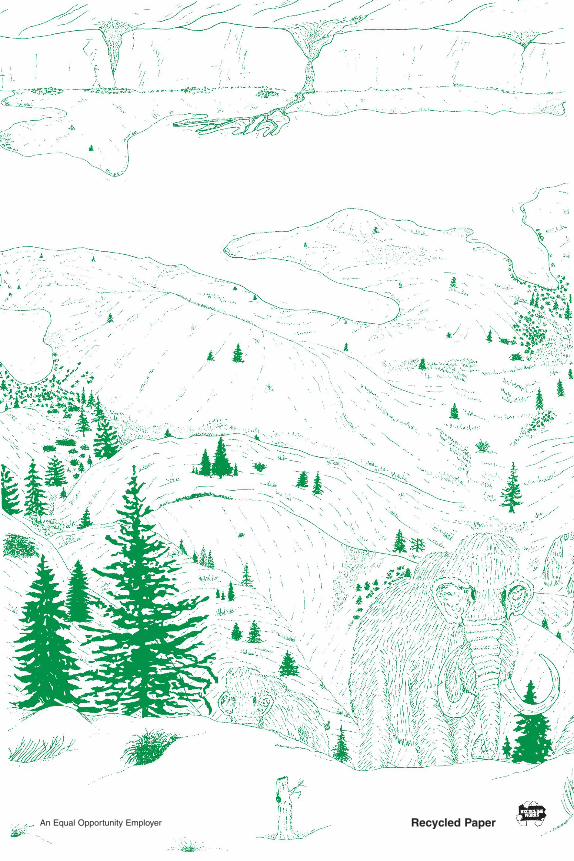
FRONT COVER: The wooly mammoth—a Pennsylvania resident during the Ice Age (modified from Thomas, D. J., and others, 1987, Pleistocene and Holocene geology of a dynamic coast: Annual Field Conference of Penn sylvania Geologists, 52nd, Erie, Pa., Guidebook, front cover).

Educational Series 6
Pennsylvaniaand theIce Age
by W. D. Sevon, Gary M. Fleeger, and Vincent C. Shepps
PENNSYLVANIA GEOLOGICAL SURVEY
FOURTH SERIES
HARRISBURG
1999
When reproducing material from this book, please cite the source as follows:
Sevon, W. D., Fleeger, G. M., and Shepps, V. C., 1999, Pennsylvania and the Ice Age (2nd ed.): Penn sylvania Geological Survey, 4th ser., Educational Series 6, 30 p.
Permission to reproduce an illustration taken from another source must be obtained from the original publisher. See credits under illustrations.
PennsylvaniaDepartment of Conservation and Natural Resources
www.dcnr.pa.gov
Bureau of Topographic and Geologic Surveywww.dcnr.pa.gov/Geology
Illustrations drafted by John G. Kuchinski
First Edition, 1962Fifth Printing, May 1978
Second Edition, May 1999Fifth Printing, Slightly Revised, March 2018

PENNSYLVANIA AND THE ICE AGE
by W. D. Sevon, Gary M. Fleeger, and Vincent C. Shepps
Have you heard the story of the Ice Age, a time when large sheets
of moving ice (glaciers) blanketed the northern half of North America?
Unbelievable though it may seem, half of our continent was once buried
beneath thousands of feet of ice. Not only that, but scientific studies by
many geologists show that there was not just one, but several ice ages, or
glaciations as they are usually called. In this booklet are descriptions of
the basic nature of glaciation, how the several glaciations affected North
America in general, and how they changed Pennsylvania in particular.
The Ice Age occurred during the Pleistocene Epoch. The Pleistocene
is a time subdivision of the Quaternary Period, which in turn is a time
subdivision of the Cenozoic Era. The Pleistocene began approximately
1.6 million years ago. Many scientists are convinced that the time in
which we are living is an interlude between ice advances and, therefore,
that the end of the Pleistocene has not yet occurred. However, we need
not worry about the return of glaciers to Pennsylvania. If ice began to
accumulate today to form an ice sheet, it would be centuries before that
ice began to move as a glacier, and then centuries more before it would
reach Pennsylvania.
We know with certainty that ice sheets of the past moved ponder-
ously out of Canada and southward into the United States for hundreds
of miles. The effects of these glaciations have significantly impacted the
historic and economic development of the United States. For example, the
Great Lakes have played a major role in determining political bounda-
ries, in the economic development of the regions that surround them,
and in the transportation and urban development of the area. Yet these
lakes did not exist prior to the Ice Age.
STUDYING GLACIERS
Investigations into the past show that glaciers existed during only a
relatively few short epochs of time within the earth’s 4.5 billion or more
years of existence. Large glaciations occurred about 600 million and 300
million years ago, but knowledge about those glaciations is limited. Gla-
ciers existing today are being studied by many scientists from all over the
world. This research receives limited attention in today’s newspapers,
magazines, or television, but it is well reported in many professional jour-
nals, some of which are dedicated entirely to the subject of glaciation.
Why study present glaciers? Because it is through studies of present
geological activities that we obtain information needed to properly inter-
pret events of the past. The more we know about the present, the better
1

we are able to evaluate the past and predict the future. From studies ofmany glaciers we have learned, for example, how glaciers form, howthey move, how they erode, and what happens when they melt and dis-appear. We know much about the material they leave behind when theyare gone. We can utilize the knowledge obtained from these many stud-ies to describe glaciers and their activities in such a manner that thereader can create a mental picture of a glacier from its birth to its death.
WHAT IS A GLACIER?
Most people have seen pictures of glaciers and know that they aremade of ice. But what more do we know about them? How do they form?Picture in your mind a high mountain with broad, deep valleys cut intoits side. During the many months of winter, snow falls on the mountainand into the valleys until a considerable depth of snow has piled up. Thishappens every year in many parts of the country, but glaciers seldomform. Why not? Because the snow in the valley melts in the summer heat.This is the first clue as to how and where glaciers form. In the northernlatitudes, such as in Alaska, and in many areas of high elevation, snowthat falls in the winter does not completely melt away in the summer.Perhaps 100 feet of snow falls, and 90 feet of snow melts away. Whenwinter comes again, there is already 10 feet of snow from the previouswinter. As this cycle of snowfall exceeding snowmelt is repeated yearafter year after year, great quantities of snow will gradually accumulate.
Snow is a form of ice. As the thickness of accumulating snow in-creases, its weight causes increased pressure at the bottom of the snowpile. The result of this pressure is that snow turns to a more dense formof ice. The pressure first turns the snow to ice granules called firn. Then,as the weight of more snow causes the pressure to increase, firn turnsto solid, blue, glacial ice. It is possible to see an example of the tran-sition from snow to firn to dense ice in any area where snow falls. Afterthe next snowfall, watch what happens to the snow. After a few days,the snowflakes will have turned to firn, particularly if the weather be-comes warmer. After a longer time, small patches of dense ice will ap-pear. When snow is melting, the last remnants are nearly always denseice. This change occurs in our climate because of temperature rather thanpressure, but the results are similar. However, one big difference be-tween the ice we observe and glacial ice is its color. Our dense ice willbe dull white or gray because it contains lots of air bubbles. In glacialice almost all of the air bubbles have been driven away because of thepressure. The color of glacial ice is blue. An accumulation of 100 feet ormore of snow that lasts throughout the year is necessary before granulesturn to glacial ice.
2 PENNSYLVANIA AND THE ICE AGE

WHAT IS A GLACIER? 3
Snowflake Transforming Firn Glacial ice
Transformation of snow to glacial ice through pressure. Modified from Flint, R. F., Glacial and Quaternary geology, Figure 3-4, p. 21, copyright © 1971 by John Wiley & Sons, Inc. Reprinted by permission of fohn Wiley & Sons, Inc.
Suppose an area has accumulated a thickness of 200 feet of glacial ice. Is this now a glacier? No. A mass of ice must be moving, or must have moved in the past, to be called a glacier. If a mass of ice has never moved, it is called a snowfield.
Movement begins whenever the ice becomes so thick that the weight of the ice is great enough to overcome the friction (resistance to movement) within the ice itself or between the ice and the underlying surface . Much of the movement of glacial ice occurs within the ice itself. However, movement of the whole mass of ice over the underlying surface also occurs. At present, the relative amounts of each type of movement are unknown. Because ice accumulation is normally greatest near the top of a mountain, ice moves out of that area and flows down the valleys of the mountain. When there is a balance between ice accumulation and melting, the glacier maintains a particular thickness, length, and terminus (end position). If ice accumulation exceeds melting, the glacier thickens and lengthens, and its terminus advances. If melting exceeds accumulation, the glacier thins and shortens, and its terminus retreats.
Two major types of glaciers exist: valley glaciers (also called mountain glaciers) and continental glaciers (also called ice sheets). Valley glaciers are those that flow down valleys in mountainous areas. The central location for Valley glaciers.

4 PENNSYLVANIA AND THE ICE AGE
snow accumulation is at the head of the valley. This area is called a cirque. When glacial ice attains the ability to flow, it moves out of the cirque and down the valley. The path that the glacier follows is controlled by the valley in which it is flowing. Several small valley glaciers may join to form a larger valley glacier in the same manner that small streams join to form larger streams.
Continental glaciers are not restricted to valleys; rather, they can flow over both hills and valleys and can cover regions encompassing thousands of square miles. Whereas valley glaciers are commonly only a few hundred feet thick, continental glaciers are thousands of feet thick. The thickness of continental glacial ice is much greater than the height of any underlying hills or the depth of any underlying valleys. Therefore, the orientation of the hills and valleys does not control the direction of
flow of continental glaciers. They move outward in all directions from that part of the glacier that either has the highest elevation or the greatest thickness of ice. This type of movement can be compared to the movement of pancake batter poured onto a griddle. The batter moves outward in all directions from the thickest mass in the middle. As the batter flows outward, it becomes thinner and eventually stops flowing. If more batter is poured onto the center of the pancake, the edges will again advance while the center flattens out. Glaciers in Greenland and Antarctica are
Flow of pancake batter. the only continental glaciers existing today.
THE ICE MOVES: EROSION
Let us think about a valley glacier that is slowly flowing down the side of a mountain. What is happening down inside the glacier and at its base? We know that valleys through which ice once flowed, such as Yosemite in California, have an entirely different appearance from valleys that have not been glaciated, such as the Grand Canyon. The glaciated valleys have steeper walls and flatter floor bottoms than stream valleys. When viewed looking up or down the valley, a glaciated valley is U-shaped. This contrasts with valleys that have been eroded by streams. These valleys are normally V-shaped. Because glaciers move down valleys originally eroded by streams, it would appear that the ice has performed a great feat of erosion in wearing away the valley and

Unglaciated valley.
THE ICE MOVES: EROSION 5
Glaciated valley.
Sandy ice scratches surface.
changing its shape. Such is indeed the case. In spite of their slow movement, and the fact that ice is much softer than rock, glaciers are powerful eroding agents. How can this be? To illustrate the reason, let us consider a clean ice cube fresh out of the tray. If you slide this block of ice across a smooth surface, the only result will be cold fingers and melt-ed ice. Try something else. Press the ice into sand and then repeat the experiment, sliding the ice across the surface. The surface would then be scratched. True, the ice did not scratch the surface, but the sand grains sticking to the ice acted as tools, and they did the scratching.
As a glacier moves across the land, loose sand and rocks of all sizes are frozen into the bottom of the ice. This happens because the bases of most glaciers, particularly continental glaciers, are constantly melting and freezing. These pieces of debris become cutting tools, just the same as the sand in the experiment. This debris, aided by the weight of the ice, scratches, scrapes, and gradually wears away the surfaces over which the glacier moves. Compare a glacier to a coarse file. The file will abrade the surface across which it is rubbed in proportion to the amount of pressure placed on the file by the user: more pressure causes more abrasion. The principal works for glaciers: greater ice thickness produces greater erosion.
Other erosional processes are also performed by glacial ice. As the glacier moves across rock material that is not loose, the glacial ice may freeze onto the material and tear it loose. Such plucked material then becomes part of the sediment load in the ice. This process of plucking is assisted by water that penetrates cracks in the rock. When this water freezes, it expands. Ice in the cracks puts pressure on the rock, making it easier for the glacier to pluck the rock from the land. A file in action.

6 PENNSYLVANIA AND THE ICE AGE
THE ICE MELTS: DEPOSITION
Melting of moving glacial ice occurs during the warmer summer months. As a glacier melts, some of its debris is dropped directly onto the ground. This deposit is called till, although many geologists today
EM End moraine IB Ice blocks OP Outwash plain BS Braided stream D Delta L Lake T Tunnel
GM Ground moraine EM End moraine CF Crevasse filling E Esker K Kettles OP Outwash plain D Delta LD Lake deposit
Continental glacier at position of maximum advance.
Glaciated area after continental glacier has melted (retreated).
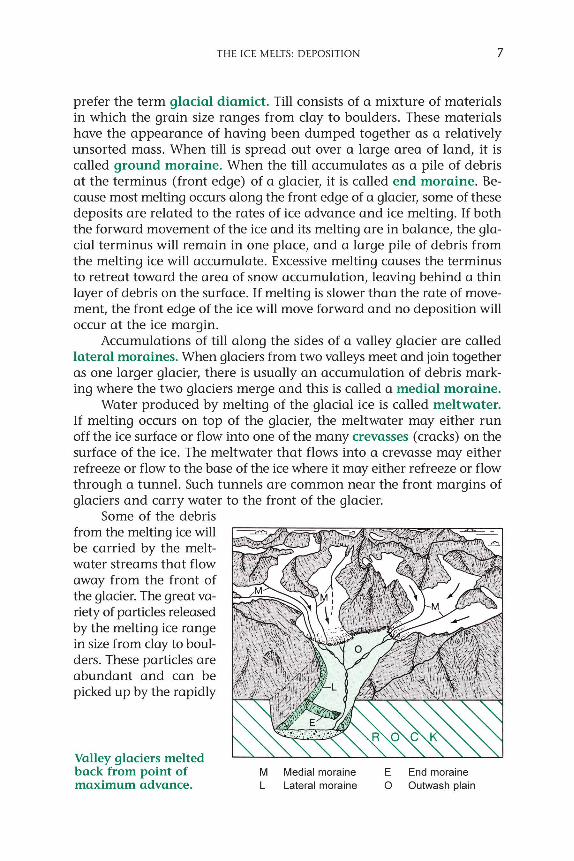
THE ICE MELTS: DEPOSITION 7
prefer the term glacial diamict. Till consists of a mixture of materials in which the grain size ranges from clay to boulders. These materials have the appearance of having been dumped together as a relatively unsorted mass. When till is spread out over a large area of land, it is called ground moraine. When the till accumulates as a pile of debris at the terminus (front edge) of a glacier, it is called end moraine. Because most melting occurs along the front edge of a glacier, some of these deposits are related to the rates of ice advance and ice melting. If both the forward movement of the ice and its melting are in balance, the glacial terminus will remain in one place, and a large pile of debris from the melting ice will accumulate. Excessive melting causes the terminus to retreat toward the area of snow accumulation, leaving behind a thin layer of debris on the surface. If melting is slower than the rate of movement, the front edge of the ice will move forward and no deposition will occur at the ice margin.
Accumulations of till along the sides of a valley glacier are called lateral moraines. When glaciers from two valleys meet and join together as one larger glacier, there is usually an accumulation of debris marking where the two glaciers merge and this is called a medial moraine.
Water produced by melting of the glacial ice is called meltwater. If melting occurs on top of the glacier, the meltwater may either run off the ice surface or flow into one of the many crevasses (cracks) on the surface of the ice. The meltwater that flows into a crevasse may either refreeze or flow to the base of the ice where it may either refreeze or flow through a tunnel. Such tunnels are common near the front margins of glaciers and carry water to the front of the glacier.
Some of the debris from the melting ice will be carried by the meltwater streams that flow away from the front of the glacier. The great variety of particles released by the melting ice range in size from clay to boulders. These particles are abundant and can be picked up by the rapidly
Valley glaciers melted back from point of maximum advance.
M Medial moraine L Lateral moraine
E End moraine 0 Outwash plain
8 PENNSYLVANIA AND THE ICE AGE
moving meltwater streams. Thus, most streams flowing from the ice carry an abundance of sediment. This is true whether the meltwater is from a valley glacier or a continental glacier. Often, the meltwater carries so much silt and clay, called glacial flour, that the water looks like milk. As a meltwater stream moves away from a glacier, its rate of flow decreases to the point where the stream can no longer carry its sediment load. When this happens, the stream "sorts" the debris by depositing different sizes of material in different places. The slowing stream will first drop the boulders, then the gravel, then the sand, and finally the silt and clay. This last fraction (the silt and clay) is dropped when the meltwater is almost standing still. Deposits of this type, called fluvial sediments, commonly have a noticeable bedded (layered) appearance.
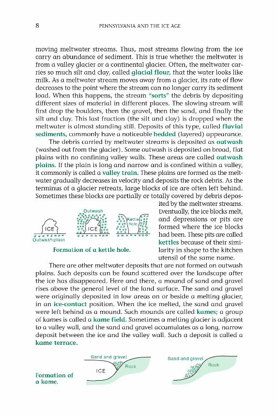
The debris carried by meltwater streams is deposited as outwash (washed out from the glacier). Some outwash is deposited on broad, flat plains with no confining valley walls. These areas are called outwash plains. If the plain is long and narrow and is confined within a valley, it commonly is called a valley train. These plains are formed as the meltwater gradually decreases in velocity and deposits the rock debris. As the terminus of a glacier retreats, large blocks of ice are often left behind. Sometimes these blocks are partially or totally covered by debris depos
oooOOOc::>O
Outwash plain
Formation of a kettle hole.
ited by the meltwater streams. Eventually, the ice blocks melt, and depressions or pits are formed where the ice blocks had been. These pits are called kettles because of their similarity in shape to the kitchen utensil of the same name.
There are other meltwater deposits that are not formed on outwash plains. Such deposits can be found scattered over the landscape after the ice has disappeared. Here and there, a mound of sand and gravel rises above the general level of the land surface. The sand and gravel were originally deposited in low areas on or beside a melting glacier, in an ice-contact position. When the ice melted, the sand and gravel were left behind as a mound. Such mounds are called kames; a group of kames is called a kame field. Sometimes a melting glacier is adjacent to a valley wall, and the sand and gravel accumulates as a long, narrow deposit between the ice and the valley wall. Such a deposit is called a kame terrace.
Formation of a kame.
Sand and gravel Rock
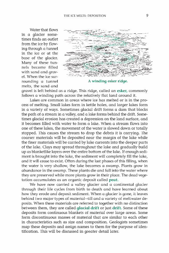
Water that flows in a glacier sometimes finds an outlet from the ice by flowing through a tunnel in the ice or at the base of the glacier. Many of these tunnels become filled with sand and gravel. When the ice sur-
THE ICE MELTS: DEPOSITION
rounding a tunnel A winding esker ridge. melts, the sand and
9
gravel is left behind as a ridge. This ridge, called an esker, commonly follows a winding path across the relatively flat land around it.
Lakes are common in areas where ice has melted or is in the process of melting. Small lakes form in kettle holes, and larger lakes form in a variety of ways. Sometimes glacial drift forms a dam that blocks the path of a stream in a valley, and a lake forms behind the drift. Sometimes glacial erosion has created a depression on the land surface, and it becomes filled with water to form a lake. When a stream flows into one of these lakes, the movement of the water is slowed down or totally stopped. This causes the stream to drop the debris it is carrying. The coarser materials will be deposited near the margin of the lake while the finer materials will be carried by lake currents into the deeper parts of the lake. Clays may spread throughout the lake and gradually build up as blanketlike layers over the entire bottom of the lake. If enough sediment is brought into the lake, the sediment will completely fill the lake, and it will cease to exist. Often during the last phases of this filling, when the water is very shallow, the lake becomes a swamp. Plants grow in abundance in the swamp. These plants die and fall into the water where they are preserved while more plants grow in their place. The dead vegetation accumulates as an organic deposit called peat.
We have now carried a valley glacier and a continental glacier through their life cycles from birth to death and have learned about how they erode and deposit sediment. When a glacier is gone, it leaves behind two major types of material-till and a variety of meltwater deposits. When these materials are referred to together with no distinction between them, they are called glacial drift or just drift. Some of these deposits form continuous blankets of material over large areas. Some form discontinuous masses of material that are similar to each other in characteristics such as size and composition. Geologists sometimes map these deposits and assign names to them for the purpose of identification. This will be discussed in greater detail later.

10 PENNSYLVANIA AND THE ICE AGE
A
Lake su rtace
Rock
c
Transitional change from a kettle lake to a peat bog to a forest.
DEVELOPMENT OF THE ICE AGE
The history of the glaciations that were so prominent in the Pleistocene Epoch starts about 16 million years ago, during the middle Miocene Epoch, about 14 million years before the start of the Pleistocene. At this time (and probably even before), the world climate began to get cooler, and ice began to accumulate in the Arctic and Antarctic. As these ice masses grew larger, they contributed to further cooling of the earth. By 1. 6 million years ago, the climate was so cool that ice began to accumulate in Canada. Eventually, the ice became a glacier and moved slowly southward.
Where did the water come from to create all of this ice? A good question. All of our water ultimately comes from the oceans that cover about 71 percent of the earth's surface. Water is evaporated from the oceans, falls to the land as rain or snow, and returns to the oceans through rivers. This cycle, called the hydrologic cycle, allows sea level to remain constant because the volume of water in the oceans remains the same. When the normal hydrologic cycle is interrupted by the formation of glacial ice, less water is returned to the oceans than is removed, and sea level drops. During the last glaciation, the Laurentide ice sheet, which was centered on Hudson Bay in Canada, became almost 2 miles thick in the Hudson Bay area. This ice and all the other glacial ice that formed at that time decreased the volume of ocean water enough to cause sea level to drop 300 feet or more. This means that about 18,000 years ago the Atlantic Ocean shoreline of eastern North America was about 60 miles east of its present position. The actual distance from its present position varied depending upon the slope of the ocean floor at any particular

DEVELOPMENT OF THE ICE AGE 11
Area of North America covered by Laurentide ice during the last glaciation.
place. At the end of the glaciation, the water returned to the oceans from melting ice caused sea level to rise gradually to its present position. Sea level is continuing to rise today at a rate of about 0.04 inch per year because glacial ice is still melting in various parts of the world.
Modified from Hint, R. F., Glacia l a nd Quaterna ry geology, Figure 18-5, p. 478, copyright © 1971 by John Wiley & Sons, Inc. Reprinted by permission of John Wiley & Sons, Inc.
Another effect of the accumulation of thick ice sheets is depression of the earth's surface. The development of an ice sheet nearly 2 miles thick in the Hudson Bay region caused that area to be depressed (sink) at least 1,500 feet and probably more. Now that the ice has all melted,
78, w w
72,
700 the depressed area has re
Boston 42 ° -----------
--·'\ ... t
bounded (risen) more than 1,000 feet and is still on the rise. The ice was much thinner in Pennsylvania, possibly no more than 2,000 to 3,000 feet thick. Therefore, the amount of depression and subsequent rebound would have been less. Evidence of depression by glacial ice and subsequent rebound in Pennsylvania occurs in beach ridges along Lake Erie. These ridges were
40°
38 '
36°
I
' > PENNSYLVAN lA / ~~r~
I
... 1 .....
Philadelp!;lia ,-
Atlantic
Ocean
SCALE 50 100 Ml
I I I 11
50 100 150 KM
Shoreline position during the last glaciation.

formed when the drainage of Lake Erie was blocked by glacial ice to thenorth and east of the Pennsylvania shoreline. At the time the beach ridgesformed, the nearby ice thickened from southwest to northeast. Thus, theland surface was depressed more in the northeast. Now that the ice isgone, the land has risen more in the northeast, and, as a result, the once-level Pennsylvania beach ridges rise 60 feet from the southwest to thenortheast.
GLACIATIONS OF THE PAST
Using the premise that the present is the key to the past, scientistsstudy modern glaciers to see how different kinds of glacial deposits areformed. They also study the deposits of now-melted glaciers to learnabout those glaciers. For example, suppose a continental glacier movedinto Pennsylvania and then melted away; the front edge of the glacierretreating north into Canada. That glacier would leave behind a varietyof deposits similar to those we have previously discussed. Suppose alsothat tens of thousands of years later the same ice mass, which had sur-vived all that time in Canada, began to grow again and and once moremoved into Pennsylvania, but not as far south as the glacier did the firsttime. Suppose also that after the glacier reached its point of farthestadvance, it melted away completely. How would we be able to tell now,many thousands of years later, that these events had occurred?
We would be able to tell that separate glaciations had occurred byexamining the deposits left by the two advances of ice and by notingthe differences between the deposits. For example, both glaciers wouldhave deposited an end moraine to mark their positions of farthest ad-vance, but the second end moraine would not be as far south as the firstend moraine. Each ice sheet also would have deposited ground moraineon top of much of the land surface. However, in some places, groundmoraine deposited by the second glacier would be piled on top of groundmoraine deposited by the first glacier. The bottom material would bethe older material, and the upper material would be the younger. Thisvertical stacking of identifiably different materials is called stratigraphy.
The study of glacial stratigraphy allows geologists to interpretmany things about now-melted glaciers, including how many times dif-ferent glaciers crossed the land surface in a particular place. The studyof glacial deposits has revealed an interesting history of the Ice Age.The story is not complete, however, for not all areas of North Americahave been studied. There are also other problems. In Pennsylvania, forexample, many of the deposits of the earliest ice advances have beeneroded away, either by younger glaciers or by the regular processes oferosion that are always working on the landscape.
12 PENNSYLVANIA AND THE ICE AGE

After the ice sheets of a particular glaciation melted away, therewould be a period of time during which the climate in North Americawas mild and there were no glaciers. This period of time is known asan interglacial period. There have been several glaciations and sub-sequent interglacial periods in North America. The present time will bepart of another interglacial period if, in the distant future, ice againaccumulates in Canada and moves south.
Each glaciation accomplished all of those things characteristic ofmoving and melting ice masses. As the ice moved along with pieces ofrock frozen to its base, it scraped the underlying surface. In places, iteroded away any loose material and, in some cases, even the hard bed-rock itself. It picked up rock pieces all the way from its starting placein Canada to its stopping place. All of these pieces were deposited as agrand mixture of rock types. In some places, the advancing ice overrodeforests, and, rarely, pieces of wood are found in glacial till. As the icemelted, it left behind all of the various types of deposits associated witha glacier. Because each ice sheet did all of these things, each younger icesheet destroyed some or all of the evidence of earlier ice sheets.
THE ICE AGE IN PENNSYLVANIA
The story of the Ice Age in Pennsylvania is fascinating and complex.The story is the result of many geologists carefully piecing together thou-sands of items of information from all parts of the Commonwealth aswell as making inferences about what happened in places where nodata exist. Let us first examine the ages of the several glaciations in Penn-sylvania, proceeding from youngest to oldest. Usually in geology, discus-sions proceed in order from oldest to youngest. We are reversing thatorder for this discussion of ages because geologists have the most infor-mation about the youngest glaciation and the least information aboutthe oldest.
The youngest glaciation is called the Wisconsinan. The glaciationis given this name because deposits from its glacier were first discovered,described, and named in Wisconsin. There were three ice advances dur-ing the Wisconsinan: the early Wisconsinan, the middle Wisconsinanand the late Wisconsinan. We are concerned only with the late Wiscon-sinan because the early and middle Wisconsinan glaciers did not reachPennsylvania. Age dating of the late Wisconsinan glaciation is easy.
There is a laboratory technique involving some sophisticated equip-ment that allows scientists to determine the age of materials that con-tain the element carbon. This technique is called radiocarbon dating.Carbon occurs in materials such as wood or charcoal, or even in minutequantities of very fine organic material present in mud. By radiocarbon
THE ICE AGE IN PENNSYLVANIA 13
14 PENNSYLVANIA AND THE ICE AGE
dating material from above and below the deposits of sediment left by the late Wisconsinan glacier, scientists have firmly established that in the United States the late Wisconsinan glaciation occurred between about 25,000 and 12,000 years ago. Local testing indicates that the ice was in Pennsylvania between about 22,000 and 17,000 years ago, reaching its maximum extent about 20,000 years ago.
It would be nice if the radiocarbon-dating technique could be used to date all glaciations, but, unfortunately, the technique cannot be used for materials more than 70,000 years old. Therefore, in order to date older glaciations, scientists use a much different and, at first glance, an apparently unrelated source of data—fossils from oceanic sediments!
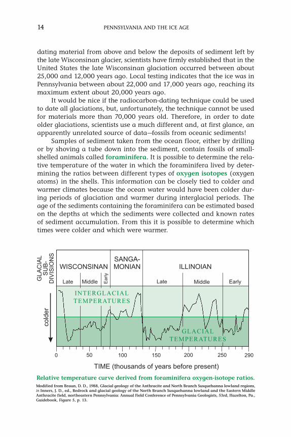
Samples of sediment taken from the ocean floor, either by drilling or by shoving a tube down into the sediment, contain fossils of small-shelled animals called foraminifera. It is possible to determine the rela-tive temperature of the water in which the foraminifera lived by deter-mining the ratios between different types of oxygen isotopes (oxygen atoms) in the shells. This information can be closely tied to colder and warmer climates because the ocean water would have been colder dur-ing periods of glaciation and warmer during interglacial periods. The age of the sediments containing the foraminifera can be estimated based on the depths at which the sediments were collected and known rates of sediment accumulation. From this it is possible to determine which times were colder and which were warmer.
Relative temperature curve derived from foraminifera oxygen-isotope ratios.Modified from Braun, D. D., 1988, Glacial geology of the Anthracite and North Branch Susquehanna lowland regions, in Inners, J. D., ed., Bedrock and glacial geology of the North Branch Susquehanna lowland and the Eastern Middle Anthracite field, northeastern Pennsylvania: Annual Field Conference of Pennsylvania Geologists, 53rd, Hazelton, Pa., Guidebook, Figure 5, p. 13.
SANGA-MONIAN ILLINOIANWISCONSINAN
Late LateMiddle Middle EarlyEarly
cold
er
GLA
CIA
LS
UB
-D
IVIS
ION
S
TIME (thousands of years before present)
0 50 100 150 200 250 290
INTERGLACIAL
TEMPERATURES
GLACIAL
TEMPERATURES

THE ICE AGE IN PENNSYLVANIA 15
We have already established with radiocarbon dating that the late Wisconsinan glaciation occurred 25,000 to 12,000 years ago, and this time period is indicated as a period of cold by the oxygen-isotope ratios. As shown on the centerfold map, the next oldest glaciation in Pennsyl-vania, the late Illinoian, advanced farther south than the late Wiscon-sinan glaciation. This means that the late Illinoian ice sheet was larger than the late Wisconsinan ice sheet, which implies that the climate was colder during the late Illinoian glaciation. The temperature curve derived from the oxygen-isoptope ratios indicates that a colder climate did occur during the late Illinoian, 191,000 to 130,000 years ago. The period was colder, but not much colder, and this fits well with the mapped extent of the late Illinoian glacier in Pennsylvania, which is 6 to 10 miles be-yond the late Wisconsinan glacial border.
Looking at the centerfold map again, we note that the next older glaciation, the pre-Illinoian, advanced much farther south than the late Illinoian. Paleotemperature estimates derived from oxygen-isotope ratios and shoreline-position data indicate that there were several glacial episodes between 191,000 and 2,400,000 years ago. Unfortunately, at present there is no technique that will allow us to determine the glacial episode to which the pre-Illinoian deposits of Pennsylvania belong. How-ever, there is a laboratory technique that allows us to establish a mini-mal age for these deposits—the analysis of magnetic polarity.
Most clay-size particles contain a small quantity of iron, which has magnetic polarity. When clay-size particles settle in a standing body of water, such as a lake, the iron orients the particles with the earth’s mag-netic field. This is of considerable value because the earth’s magnetic field occasionally reverses direction. At present the magnetic negative (north) pole is in the northern hemisphere, and the polarity is referred to as normal. Between 2,400,000 and 770,000 years ago, the magnetic negative pole was in the southern hemisphere, and the polarity was re-versed. A lake clay containing iron whose orientation indicates reversed polarity occurs in north-central Pennsylvania at Antes Fort, west of Wil-liamsport. This lake clay overlies pre-Illinoian glacial till. Because of the reversed polarity of the overlying lake clay, we know that the till was deposited at least 770,000 years ago.
Look again at the map in the center of the book. Three glaciations are indicated on the map, which shows glacial deposits that occur at the surface. In western Pennsylvania, geologists have examined materials exposed in the highwalls of many coal strip mines and along many ex-cavations for roads. These exposures contain a variety of materials that are attributed to deposition by an ice sheet. Some of these exposures show deposits from four different glaciations. Because these materials are stacked in a vertical sequence, we can assume that the oldest material is on the bottom and the youngest is on the top. With this concept in

16 PENNSYLVANIA AND THE ICE AGE
0 Yellow-brown till
~w 8 0() _Ji::t:
wa::~ !Il::JCii
16 J:(/)~ I- ~ c..O wZ o:)
24
HORIZONTAL SCALE
0 100 FT
A vertical sequence of glacial materials in a man-mode exposure is on example of stratigraphy that allows geologists to interpret post events. Modified from White, G. W., a nd others, 1969, Pleistocene stratigra phy of northwestern Pennsylvania, Pennsylvania Geological Survey, 4 th ser., General Geology Report 55 , Figure 18, p. 70.
mind, we can also examine the materials and try to locate similar materials at the surface. This is possible with the upper three of the different glacial materials, but not with the fourth, the lowermost and oldest glacial sediment. This sediment, called the Slippery Rock Till (so named because it was first discovered near the community of Slippery Rock), does not occur at the surface beyond the limits of the younger glaciations; rather, it is buried beneath younger glacial deposits everywhere it occurs. Thus, we can infer that either the ice sheet that deposited it did not extend as far as the ice sheets that came later or all Slippery Rock material that once lay beyond the limits of younger overlying deposits has been eroded. The preserved till is very weathered, which suggests that it is very old, but we really do not know anything more about the till or the glacier that deposited it.
You might wonder if the Slippery Rock Till is the same age as the till at Antes Fort. A good question. Geologists often identify glacial deposits as being the same age by using a method called correlation. When deposits separated by some distance, such as tills in northwestern and northeastern Pennsylvania, are shown to have similar characteristics, such as composition, degree of weathering, and ground location relative to other deposits, they are assumed to be related deposits. That is, they are correlated. The Slippery Rock Till and the till at Antes Fort have nothing in common that allows such a correlation; rather, the till at Antes Fort is correlated with the till that immediately overlies the Slippery Rock Till, the Mapledale Till. Thus, the best we can say is that the Slippery Rock Till is older than the till at Antes Fort.
Perhaps a bigger question in your mind is how did the Slippery Rock Till get preserved when it was overridden by subsequent ice sheets, which
THE ICE AGE IN PENNSYLVANIA 17
are known to erode the underlying material. Also, is there any evidence of this till in eastern Pennsylvania? Good questions. The ground surface of the glaciated part of northwestern Pennsylvania is relatively flat in comparison with the ground surface of northeastern Pennsylvania. Presumably, the materials at the surface, such as the Slippery Rock Till, were frozen to considerable depth before being overridden by the next ice sheet. Because the ground was frozen, and because the surface was relatively flat, there apparently was very little erosion in many places. This was a contrast to the eastern part of the state. There the land surface is very irregular, and each moving ice sheet eroded most unconsolidated material, frozen or not, and some bedrock as well.
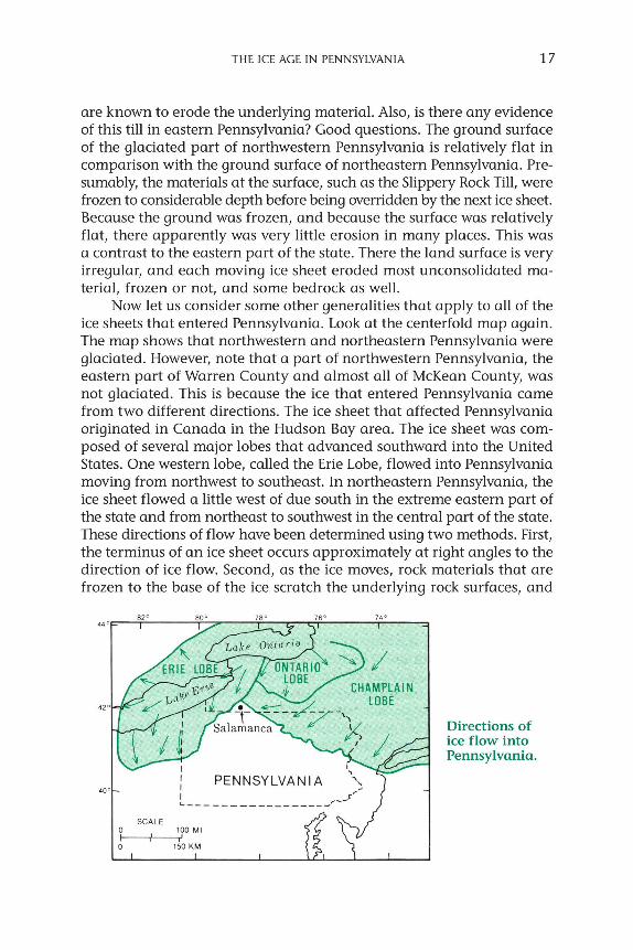
Now let us consider some other generalities that apply to all of the ice sheets that entered Pennsylvania. Look at the centerfold map again. The map shows that northwestern and northeastern Pennsylvania were glaciated. However, note that a part of northwestern Pennsylvania, the eastern part of Warren County and almost all of McKean County, was not glaciated. This is because the ice that entered Pennsylvania came from two different directions. The ice sheet that affected Pennsylvania originated in Canada in the Hudson Bay area. The ice sheet was composed of several major lobes that advanced southward into the United States. One western lobe, called the Erie Lobe, flowed into Pennsylvania moving from northwest to southeast. In northeastern Pennsylvania, the ice sheet flowed a little west of due south in the extreme eastern part of the state and from northeast to southwest in the central part of the state. These directions of flow have been determined using two methods. First, the terminus of an ice sheet occurs approximately at right angles to the direction of ice flow. Second, as the ice moves, rock materials that are frozen to the base of the ice scratch the underlying rock surfaces, and
I
' PENNSYLVANIA \ L -------- _________ ,. ___ r"'
SCALE 100 Ml
t---+----r 150 KM
Directions of ice flow into Pennsylvania.

these scratches, called glacial striae, are parallel with the direction ofice flow. The two lobes met in the area of Salamanca, N. Y., north ofBradford, Pa. (McKean County).
Deposits of the older glaciations, the late Illinoian and pre-Illinoian,have been considerably eroded where they occur beyond the limits oflater glaciations. Therefore, it is difficult to say what the surface glaciatedby those ice sheets looked like prior to the next glaciation. Because thedeposits that have survived erosion resemble in general character thoseof the late Wisconsinan glaciation, geologists generally assume that theearlier glaciations behaved in a similar fashion.
Now let us look at some of the features of the glaciated regions ofPennsylvania so that if you live in or travel to such an area you maybe able to recognize some of the evidence that glaciers once existed inPennsylvania.
Northwestern Pennsylvania
As we have already mentioned, there is evidence in northwesternPennsylvania for four different glaciations. Let us look at the appearanceof the deposits of each glaciation starting properly with the oldest andworking our way up to the youngest.
Actually, as we found out earlier, there is not much to be seen of thedeposits of the oldest glaciation. All of the preserved material of theoldest pre-Illinoian glaciation, the Slippery Rock Till, is buried beneathyounger glacial deposits. The till is reddish in color and looks ratherdrab and uninteresting. This is because the till has been deeply weath-ered, and the rocks and minerals composing it have been altered. Mosttills in northwestern Pennsylvania are a shade of gray when first de-posited and still unweathered because the till is derived primarily fromgray bedrock.
In some places, the only glacial deposits on the surface are a fewrounded boulders that are of rock types not native to northwestern Penn-sylvania. These boulders had to be transported to their present positionsby a glacier. The presence of such isolated boulders raises a questionabout the age of the glacier that deposited them. If there are glacial-sediment deposits of a known glacial age in the area, then it is assumedthat the boulders are related to that glaciation. However, where the boul-ders are found beyond any known glacial deposits, the possibility existsthat they may be remnants of Slippery Rock Till, or they may have beendeposited by an older, as yet unidentified glaciation.
The next glaciation, one geologists generally refer to as the youngerpre-Illinoian, occurred prior to 770,000 years ago. This may be the mostextensive glaciation in Pennsylvania. The boundary marking the maxi-mum extent of the glacier is not clearly defined, but there are enough
18 PENNSYLVANIA AND THE ICE AGE
deposits of till and sand and gravel that geologists have been able todevelop a fairly clear idea about where the glacier flowed.
Deposits of the younger pre-Illinoian glaciation are not abundant.Glacial till, called the Mapledale Till, and some sand and gravel com-pose the bulk of the preserved drift, but they occur only as small local de-posits scattered around the land surface. Why this spottiness of deposits?Because of erosion. During the long period of time since the materialswere deposited, there has been a lot of erosion, and most of the glacialmaterials have been carried away by water. Less than 10 percent of theland surface is covered by deposits from this ancient ice sheet. Thereare, however, more deposits of this glaciation buried beneath youngermaterials. Examination of roadcuts and strip-mine faces provides mostof the detailed information about these glacial materials.
After the Mapledale glacier melted away, the deposits that wereleft behind were weathered intensely for many thousands of years. Theoutstanding characteristic of the deposits weathered during this inter-glacial period is their reddish-yellow color. A climate that was probablywarmer and wetter than the present climate existed during this timeand weathered the glacial materials deeply. The intense color developedbecause iron minerals in the glacial deposits were altered chemicallyand stained the other materials with red.
Deposits of the next younger glaciation, the late Illinoian, are moreabundant than those of the older glaciations, and some of them coverlarge areas of ground. The materials deposited by this glaciation, mainlythe Titusville Till and ice-contact sand and gravel, are generally dullgray in color and weather brown. The late Illinoian materials are notweathered as deeply as the pre-Illinoian materials. Erosion has removedsome of these materials since they were deposited, but much of the ma-terial still remains at the surface, and much is also buried by youngerdeposits.
Most of the drift in northwestern Pennsylvania is Titusville Till andassociated deposits. These deposits contribute significantly to the topo-graphic form of the landscape of the area. During its melting, the glacierdeveloped several distinct end moraines in positions northwest of thepoint of farthest ice advance. These moraines are called recessionalmoraines because they were developed as the ice front was receding.The Titusville glacier apparently was never stable at its farthest extent,but after the ice front retreated several miles, it achieved a state ofequilibrium for a long period of time. During this time, it accumulatedlots of debris in a pile that formed the outermost recessional moraine. Inmany places, this recessional moraine is several miles wide. Eventually,melting exceeded ice advance, and the terminus retreated to the north-west. It stabilized several times after short retreats and new advances.Each time the ice stabilized, it built a recessional moraine at the ice front.
THE ICE AGE IN PENNSYLVANIA 19
20 PENNSYLVANIA AND THE ICE AGE
Younger glacial deposits subsequently buried all of these recessional moraines, but their topographic form is reflected upwards through the younger deposits so that the recessional moraines are still the prominent glacial landform in northwestern Pennsylvania.
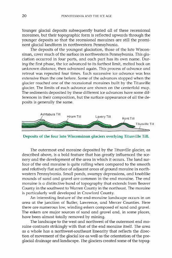
The deposits of the youngest glaciation, those of the late Wisconsinan, cover much of the surface in northwestern Pennsylvania. This glaciation occurred in four parts, and each part has its own name. During the first phase, the ice advanced to its farthest limit, melted back an unknown distance, then advanced again. This process of advance and retreat was repeated four times. Each successive ice advance was less extensive than the one before. Some of the advances stopped when the glacier reached one of the recessional moraines built by the Titusville glacier. The limits of each advance are shown on the centerfold map. The sediments deposited by these different ice advances have some differences in their composition, but the surface appearance of all the deposits is generally the same.
Ashtabula Till
Deposits of the four late Wisconsinan glaciers overlying Titusville Till.
The outermost end moraine deposited by the Titusville glacier, as described above, is a bold feature that has greatly influenced the scenery and the development of the area in which it occurs. The land surface of the end moraine is quite rolling when compared to the smooth and relatively flat surface of adjacent areas of ground moraine in northwestern Pennsylvania. Small ponds, swampy depressions, and knoblike mounds of sand and gravel are common in the end moraine. The end moraine is a distinctive band of topography that extends from Beaver County in the southwest to Warren County in the northeast. The moraine is particularly well developed in Crawford County.
An interesting feature of the end-moraine landscape occurs in an area at the junction of Butler, Lawrence, and Mercer Counties. Here there are numerous low, winding eskers composed of sand and gravel. The eskers are major sources of sand and gravel and, in some places, have been almost totally removed by mining.
The landscape to the west and northwest of the outermost end moraine contrasts strikingly with that of the end moraine itself. The area as a whole has a northwest-southeast linearity that reflects the direction of movement of the glacial ice as well as the orientation of the preglacial drainage and landscape. The glaciers created some of the topog-

THE ICE AGE IN PENNSYLVANIA 21
raphy by erosion and some of it by deposition. The landscape includes long, linear, rounded ridges, and broad uplands separated by linear valleys that are, in places, swampy. Interstate Route 79 crosses several of the distinctive valleys (e.g., Lake Wilhelm and Conneaut Marsh) between its junctions with Interstate Route 80 and Interstate Route 90. The linear valleys and surrounding areas contain a variety of deposits. The sequence of events and the resulting deposits are typically complex and may differ from one valley to the next.
As a glacier melted, the uplands became free of ice while the valleys were still filled with ice, almost in the form of valley glaciers. The melting glacier would deposit a thin layer of till on much of the uplands, although nothing would be deposited in some places. Once the ice was confined to a valley, a variety of things happened. Meltwater carried lots of sand and gravel, and deposited it in many places: holes in the ice (kames), tunnels under the ice (eskers), between the ice and the valley wall (kame terraces), and on the valley floor beyond the ice (outwash plain or valley train). Blocks of ice buried by outwash eventually melted and created kettle holes that filled with water to become lakes.
Sometimes the glacier made small readvances down the valley. During such a read vance, the ice eroded some of the previous deposits and deposited new materials, such as an end moraine confined to the valley. Some end moraines totally blocked the end of a valley, and the meltwater had no place to go. In these cases, a glacial lake formed between the end moraine and the ice. Silt and clay were deposited in these lakes.
/
Outwash plain
Diagram of deglaciation in a valley in northwestern Pennsylvania.
The landscape resulting from this process of glaciation and degla-
ciation is varied, as are the associated deposits. The uplands and upper
valley slopes are generally smooth and covered with till of variable thick-
ness. The lower valley walls and the margins of the valley bottoms com-
monly have an irregular topography composed of small knobs and un-
drained depressions. The “knobs” are kames made of sand and gravel.
Some valley walls are bordered by flat-surfaced terraces rising a few tens
of feet above the valley floor. These are kame terraces, which also are
made of sand and gravel. Small and large lakes may be found in kettle
holes. Some kettle holes that once had lakes were filled with sediments,
became swamps, and finally developed peat. Some of these peat depos-
its have been stripped away and sold as soil conditioner. Extensive, flat,
swampy areas occur above glacial-lake clays, which inhibit drainage.
There are many places one can see this type of glacial-formed scenery,
but the area around Conneaut Lake, a kettle lake in southern Crawford
County, is one of the best.
Other deposits related to the Late Wisconsinan glaciation are the
previously mentioned beach ridges that parallel the Lake Erie shoreline.
The sandy sediment of these beach ridges supports the bulk of Erie Coun-
ty’s famous grape vineyards.
One final heritage from all of the glaciations in northwestern Penn-
sylvania is drainage reversal. Prior to glaciation, all of the drainage in
northwestern Pennsylvania flowed northwest into the Lake Erie basin.
The ice sheets blocked that drainage and filled former valleys with abun-
dant amounts of debris. Meltwater from the melting ice sheets initiated
water flow to the southeast. Water that could not flow to the northwest
formed temporary lakes that overflowed old stream divides and cut
through them to form new drainage patterns. As a result, in the gla-
ciated area of northwestern Pennsylvania, streams now flow southeast
into the Allegheny River, which in turn carries the water southwestward
into the Ohio River. Gorges through which flow Slippery Rock Creek and
Oil Creek, in McConnells Mills State Park and Oil Creek State Park, re-
spectively, are the result of such drainage changes.
NNoorrtthh--CCeennttrraall aanndd NNoorrtthheeaasstteerrnn PPeennnnssyyllvvaanniiaa
The glacial deposits of north-central and northeastern Pennsylvania
are different from those in northwestern Pennsylvania in several ways.
First of all, there is little preserved vertical stratigraphy; that is, there
are very few places where older deposits are preserved under younger
deposits. This is apparently because the preglacial topography of north-
eastern Pennsylvania was quite irregular, and the advancing ice sheets
eroded the loose materials on the surface instead of overriding them.
Secondly, because of the lack of vertical stratigraphy, earlier glacial epi-
sodes can be identified only where their deposits occur beyond the limits
22 PENNSYLVANIA AND THE ICE AGE
of later glaciations. Thirdly, there is no known record of the Slippery Rockglaciation. This glaciation must have occurred in eastern Pennsylvania,but deposits either have not been preserved or have not been discovered.
Another contrast between the glacial deposits in Pennsylvania isin the materials that make up the deposits. Igneous and metamorphicmaterials from Canada are common in deposits in the northwesternarea of the state, are present to a limited extent in deposits in the north-central area, and are generally absent in deposits in the northeasternarea. A few garnet gneiss boulders from the Adirondack Mountains ofnorthern New York occur in the northeast, but not many. Most of thematerials making up the glacial deposits of north-central and northeast-ern Pennsylvania were eroded from bedrock close to where they weredeposited.
Look at the centerfold map. There is a large area of deposits in north-eastern Pennsylvania that represents a pre-Illinoian glaciation. Thedeposits of this glaciation include the till at Antes Fort and are thus allconsidered to be more than 770,000 years old. These deposits are weath-ered deeply and characteristically have an orange-red color similar tothat of the pre-Illinoian Mapledale Till in northwestern Pennsylvaniawith which they are correlated. In some places in northeastern Penn-sylvania, these old tills are called the Muncy Till, but, for the most part,the pre-Illinoian tills are unnamed. The southern boundary of this gla-ciation is poorly defined but has been located with some precision. Mostof the pre-Illinoian deposits have been eroded, and less than 10 percentof the land surface now has any materials that can be assigned to thepre-Illinoian glaciation. In addition, many of these older deposits areburied by materials that moved downslope during younger glaciations(see the section “Periglacial Phenomena” on page 25).
Between the area of pre-Illinoian deposits and the area of late Wis-consinan deposits there is a zone about 5 to 10 miles wide that has de-posits from the late Illinoian glaciation. The ice border of this glaciationapproximately parallels that of the late Wisconsinan, but it is not asclearly defined. Late Illinoian deposits are not as deeply weathered as thepre-Illinoian deposits, but they are more weathered than the late Wis-consinan deposits. The late Illinoian deposits of northeastern Pennsylva-nia are correlated with the Titusville Till of northwestern Pennsylvaniaand are locally called the Warrensville Till. As with the pre-Illinoiantills, most of the late Illinoian tills in north-central and northeasternPennsylvania are unnamed. Some of the materials deposited by the lateIllinoian glacier have been eroded since the time of deposition, and theremaining late Illinoian deposits cover less than 25 percent of the landsurface in the area where they occur.
Now let us look at the effects of the late Wisconsinan glaciation. Thepreglacial landscape in the north-central and northeastern parts of thestate was irregular and included many hills and valleys, and the gla-
THE ICE AGE IN PENNSYLVANIA 23

24 PENNSYLVANIA AND THE ICE AGE
ciated landscape that we see today reflects that topography. Most importantly, the glaciers did not blanket the land with a mass of material as in northwestern Pennsylvania. In general, the glaciers eroded the tops of the hills and deposited little or no material in those locations. Today, glacial till a few to many feet thick partially or totally fills small gullies and valleys that were cut into the hillsides prior to glaciation. Many of these filled valleys have small streams cutting new channels along the contact between the till and the bedrock wall of the valley, or in the center of the valley. Many of the larger stream valleys have till deposits along the lower parts of the valley walls, and there is commonly a noticeable change in slope at the point where the material underlying the surface changes from bedrock (steeper slope) to glacial till (shallower slope). Late Wisconsinan tills in north-central and northeastern Pennsylvania are given the name Olean Till.
Position of glacial till in small gullies and larger valleys.
Unlike northwestern Pennsylvania, north-central and northeastern Pennsylvania generally lack a linear drainage pattern parallel to the direction of ice flow. As a result, the orientations of the valleys in these glaciated areas are an important factor in the amount of outwash and other deposits that they contain. Those valleys that were more or less parallel with the direction of ice flow during glaciation were eroded deeper and now have great thicknesses of glacial deposits. The Delaware River valley between Matamoras (at the eastern tip of Pike County) and Delaware Water Gap (in southern Monroe County) was parallel to the direction of ice flow and has glacial material that, in places, is more than 200 feet thick. Most valleys that were transverse (lying crosswise) to the direction of ice flow contain only thin glacial deposits and have bedrock exposed in their streambeds. Towanda Creek valley in Bradford County and Lackawaxen Creek valley in Pike County are typical of such streams. Kames of sand and gravel occur along the margins of many valleys, both parallel and transverse, but are not abundant. Some of the larger valleys, such as those carved by Loyalsock, Lycoming, Pine, and Larrys Creeks, and some parts of the Susquehanna and Delaware
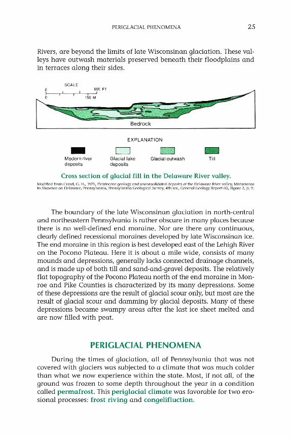
PERIGLACIAL PHENOMENA 25
Rivers, are beyond the limits of late Wisconsinan glaciation. These valleys have outwash materials preserved beneath their floodplains and in terraces along their sides.
SCALE
-Modern river deposits
EXPLANATION -Glacial lake Glacial outwash Till deposits
Cross section of glacial fill in the Delaware River valley. Modified from Crowl, G. H., 1971, Pleistocene geology and unconsolidated deposits of the Delaware River valley, Matamoras to Shawnee on Delaware, Pennsylvania, Pennsylvania Geological Survey, 4th ser., General Geology Report 60, Figure 2, p. 9.
The boundary of the late Wisconsinan glaciation in north-central and northeastern Pennsylvania is rather obscure in many places because there is no well-defined end moraine. Nor are there any continuous, clearly defined recessional moraines developed by late Wisconsinan ice. The end moraine in this region is best developed east of the Lehigh River on the Pocono Plateau. Here it is about a mile wide, consists of many mounds and depressions, generally lacks connected drainage channels, and is made up of both till and sand-and-gravel deposits. The relatively flat topography of the Pocono Plateau north of the end moraine in Monroe and Pike Counties is characterized by its many depressions. Some of these depressions are the result of glacial scour only, but most are the result of glacial scour and damming by glacial deposits. Many of these depressions became swampy areas after the last ice sheet melted and are now filled with peat.
PERIGLACIAL PHENOMENA
During the times of glaciation, all of Pennsylvania that was not covered with glaciers was subjected to a climate that was much colder than what we now experience within the state. Most, if not all, of the ground was frozen to some depth throughout the year in a condition called permafrost. This periglacial climate was favorable for two erosional processes: frost riving and congelifluction.

Frost riving is the breaking apart of a rock bythe repeated freezing and thawing of water. Whenwater freezes to form ice, its volume increases. In natu-ral fractures in a rock, this volume increase puts pressureon the sides of the fractures and forces the rock apart. If this processis repeated many times, pieces of rock are broken away from the mainrock mass. The periglacial climate was ideal for frost riving because tem-peratures rose above and fell below freezing (32°F) many times. Thepieces of rock broken from hilltop outcrops often fell down the hillsideand accumulated as blocky debris called talus or scree. All of the long,linear ridges in central Pennsylvania have debris of this type on theirslopes. Much of it is difficult to see because it is covered with vegetation.One of the best places to see talus is along U.S. Route 22/322 in the nar-rows of the Juniata River east of Lewistown. The large amount of taluscovering the slopes of many ridges indicates that frost riving must havelowered the crests of these ridges many tens of feet during the Pleistocene.Contrasting accumulations in the form of large, relatively flat fields ofpartly rounded boulders, which were also derived by frost riving, occuron very gentle slopes in numerous places in northeastern Pennsylvania.Hickory Run Boulder Field in Hickory Run State Park, Carbon County,is the finest example of such a field.
Congelifluction was an active process of debris movement duringthe summer months in the periglacial climate. It occurred on slopes cov-ered with fine-grained materials that were frozen to some depth. Whenthe ground froze, all of the available water in the ground was frozen.During the summer months, when air temperatures were warmer, theground would thaw to a depth of a few feet. The melted ice, plus anyadditional water that might have been added by the melting of snow,lubricated the soil material so that it flowed slowly, or even rapidly, downthe slope of a hillside. This process resulted in thick accumulations ofmaterial at the bases of many slopes and in small, steep gullies or valleysthat lacked streams capable of removing the debris.
26 PENNSYLVANIA AND THE ICE AGE
Water in jointsfreezes, expands,and breaks rock.
The two processes, frost riving and congelifluction, modified theappearance of the landscape to a moderate extent and produced a va-riety of sediments that are assigned the general term colluvium. Somecolluvium is present on most surfaces within the unglaciated part ofthe state. Thick colluvium (greater than 6 feet thick) occurs mainly inthe heads of small drainage basins. In other places it is frequently lessthan 3 or 4 feet thick. For the most part, the finer grained colluvial de-posits are not readily recognizable except in excavations.
In many places within the state, slopes are littered with scatteredboulders and blocks that were derived from outcrops near or at the topof the slope. Frost riving produced the pieces of rock, and congelifluc-tion moved it down the slope. The large sizes of the blocks of rock makesome of these deposits quite spectacular. One of the most sensational dis-plays is that at Rimrock Overlook in northeastern Warren County. Here,blocks of rock up to 10 to 20 feet square and 30 or more feet long havetoppled from a large rock exposure at the top of a hill and litter the slopebelow. Sometimes these processes of frost riving and congelifluction re-move a lot of rock, leaving only an isolated spire of rock called a tor. Peri-glacial processes made many modifications to the landscape during thePleistocene, but the results are not always easy to see or identify.
LIFE IN THE ICE AGE
Because of the cold climate, both animal and plant life was differ-ent in Pennsylvania during the Ice Age. Several caves containing manybones of animals that lived at that time have been discovered withinthe state, and some such bones have been recovered from sinkholes de-veloped in limestone. Pollen grains, those tiny pieces of vegetation towhich many people are allergic, are found in peat bogs and lake sedi-ments. The study of these grains gives clues about the plant life beyondthe ice during and after the late Wisconsinan glaciation.
At the height of the late Wisconsinan glaciation, about 20,000 yearsago, Pennsylvania was covered with tundra vegetation: principallygrasses, some spruce trees, and some other low shrubs. After deglacia-tion commenced, other forms of vegetation quickly started to repopulatethe state through specific plant successions that resulted in both thedeciduous (with annual leaf fall) and mixed (deciduous and evergreen)forests of today. This succession started with spruce. The spruce was firstreplaced by pine, and eventually by oak and hickory.
Of the many animals that were here during the Ice Age, some be-came extinct at the end of this glacial episode. These include the sabre-tooth cat, the mastodon, a small, three-toed horse, and the Pleistocene
LIFE IN THE ICE AGE 27
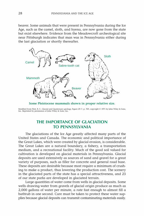
beaver. Some animals that were present in Pennsylvania during the IceAge, such as the camel, sloth, and hyena, are now gone from the statebut exist elsewhere. Evidence from the Meadowcroft archeological sitenear Pittsburgh indicates that man was in Pennsylvania either duringthe last glaciation or shortly thereafter.
THE IMPORTANCE OF GLACIATIONTO PENNSYLVANIA
The glaciations of the Ice Age greatly affected many parts of theUnited States and Canada. The economic and political importance ofthe Great Lakes, which were created by glacial erosion, is considerable.The Great Lakes are a natural boundary, a fishery, a transportationmedium, and a recreational facility. Much of the good soil valued forcultivation is developed on glacial materials in Pennsylvania. Glacialdeposits are used extensively as sources of sand and gravel for a greatvariety of purposes, such as filler for concrete and general road base.These deposits are desirable because most require a minimum of crush-ing to make a product, thus lowering the production cost. The sceneryin the glaciated parts of the state has a special attractiveness, and 23of our state parks are developed in glaciated terrain.
Large quantities of water come from wells in glacial deposits. Somewells drawing water from gravels of glacial origin produce as much as2,000 gallons of water per minute, a rate fast enough to almost fill abathtub in one second. Care must be taken to protect these water sup-plies because glacial deposits can transmit contaminating materials easily.
28 PENNSYLVANIA AND THE ICE AGE
Modified from Flint, R. F., Glacial and Quaternary geology, Figure 29–7, p. 769, copyright © 1971 by John Wiley & Sons,Inc. Reprinted by permission of John Wiley & Sons, Inc.
Some Pleistocene mammals shown in proper relative size.
CamelSabre-tooth cat
Sloth
Beaver
Mammoth
SUPPLEMENTARY READING 29
Glacial deposits are unconsolidated, loose materials that must be dealt with carefully when structures requiring firm foundations are built on them. Some glacial deposits contain abundant clay and are very sus-ceptible to slope failure in the form of landslides.
Glaciation had a profound and lasting effect on Pennsylvania. Hope-fully, this booklet has helped you to better understand some of the pro-cesses, products, and problems associated with the Ice Age.
SUPPLEMENTARY READING
Popular Reading
Glaciers, by Robert P. Sharp, 1960, Eugene, Oreg., University of Oregon Press, 78 p. An easily read discussion of glaciers, beautifully illustrated to provide the reader with visual images of the character and variation of these ice bodies.
Living ice—Understanding glaciers and glaciation, by Robert P. Sharp, 1988, New York, Cambridge University Press, 225 p. This nontechnical, well-illustrated book outlines the workings of glaciers and ice sheets, and their erosional and depositional products. Written in a readable style, this book provides the interested reader with a clear understanding of the world of moving ice.
Glaciers and the Ice Age, by Gwen Schultz, 1963, New York, Holt, Rinehart and Winston, 128 p. This small book, written for lay persons, provides a good review of the basic aspects of glaciers and emphasizes their impact upon and relationship to human interests and activities.
The world of ice, by James L. Dyson, 1962, New York, Alfred A. Knopf, Inc., 292 p. A summary of the occurrence of ice on the earth and the many forms it assumes. Considers the impact that the coming and going of the glaciers has had on man. Written in a very enjoyable style and within the grasp of the average person.
Glaciers—clues to future climate, by R. S. Williams, 1983, U.S. Geological Sur-vey, 21 p. This pamphlet provides a brief, popular, up-to-date summary on glaciers, causes of glaciation, glacial history, and climatic relationships.
Advanced Reading
Geology of the Great Lakes, by Jack L. Hough, 1958, Urbana, Ill., University of Illinois Press, 313 p. A comprehensive discussion of the history and evolu-tion of the Great Lakes.
Glaciers and landscape—A geomorphological approach, by David. E. Sugden and Brian S. John, 1976, London, Edward Arnold, 376 p. This excellent, graceful book treats glaciation and related items in a detailed and highly professional manner.
Glacial and Quaternary geology, by Richard F. Flint, 1971, New York, John Wiley and Sons, 892 p. A scholarly, dependable, and detailed compilation and
30 PENNSYLVANIA AND THE ICE AGE
discussion of data, features, and processes related to glaciation and the worldwide history of glaciation. An excellent source book of facts and ideas.
Glacial geomorphology, by Clifford Embleton and Cuchlaine A. M. King, 1975, New York, John Wiley and Sons, 573 p. This book provides a highly detailed and thoroughly professional account of most features and matters related to glaciers and their associated landscapes.
The physics of glaciers (2nd ed.), by W. S. B. Paterson, 1981, Oxford, Pergamon Press, 380 p. An excellent reference dealing with the basic mechanics of glacier formation, nourishment, structures, flow, and behavior.
Publications of the Pennsylvania Geological Survey on the Glaciation of Pennsylvania1
General Geology Report 7, Glacial deposits outside the Wisconsin terminal mo-raine in Pennsylvania, by Frank Leverett, 1934, 123 p.
General Geology Report 9, The geomorphology of the Wyoming-Lackawanna region, Pennsylvania, by H. A. Itter, 1938, 82 p.
General Geology Report 10, Recent geological history of the Delaware Valley below the Water Gap, by Freeman Ward, 1938, 76 p.
General Geology Report 23, Pleistocene terraces of the Susquehanna River, Pennsylvania, by L. C. Peltier, 1949, 158 p.
General Geology Report 32, Glacial geology of northwestern Pennsylvania, by V. C. Shepps, G. W. White, J. B. Droste, and R. F. Sitler, 1959, 59 p.
General Geology Report 55, Pleistocene stratigraphy of northwestern Pennsylva-nia, by G. W. White, S. M. Totten, and D. L. Gross, 1969, 88 p.
General Geology Report 57, Surficial geology of the Stroudsburg quadrangle, Pennsylvania-New Jersey, by J. B. Epstein, 1969, 67 p.
General Geology Report 60, Pleistocene geology and unconsolidated deposits of the Delaware Valley, Matamoras to Shawnee on Delaware, Pennsylvania, by G. H. Crowl, 1971, 40 p.
General Geology Report 64, Pleistocene beach ridges of northwestern Pennsyl-vania, by E. E. Schooler, 1974, 38 p.
General Geology Report 71, Glacial border deposits of late Wisconsinan age in northeastern Pennsylvania, by G. H. Crowl and W. D. Sevon, 1980, 68 p.
Also available are a number of surficial geologic maps that accompany atlas reports (1:24,000 scale), open-file surficial geologic map reports (1:24,000 scale), and one county report (C 52) (1:50,000 scale).
1Publications released by the Fourth Pennsylvania Geological Survey can be downloaded from links provided on a spreadsheet that is available from the Pennsylvania Depart-ment of Conservation and Natural Resource website, Geo logic Publications and Data web page: http://www.dcnr.pa.gov/Geology/PublicationsAndData/Pages/default.aspx. Look for instructions under the heading “Obtaining Geological Publications—Online.”
PENNSYLVANIA GEOLOGICAL SURVEYEDUCATIONAL SERIES
ES 1 Rocks and Minerals of Pennsylvania ES 2 Common Fossils of Pennsylvania ES 3 The Geology of Pennsylvania’s Groundwater ES 4 The Geological Story of Pennsylvania ES 5 Geology and the Gettysburg Campaign ES 6 Pennsylvania and the Ice Age ES 7 Coal in Pennsylvania ES 8 Oil and Gas in Pennsylvania ES 9 Landslides in Pennsylvania ES 10 Earthquake Hazard in Pennsylvania ES 11 Sinkholes in Pennsylvania ES 12 The Nonfuel Mineral Resources of Pennsylvania ES 13 Reading and Using Maps
COPIES OF THIS PUBLICATIONMAY BE OBTAINED FROM
PENNSYLVANIA GEOLOGICAL SURVEY3240 SCHOOLHOUSE ROAD
MIDDLETOWN, PA 17057–3534717–702–2017
Recycled PaperAn Equal Opportunity Employer
---<
~=:~;/ ~ /0:~~ . v a: ·"
II I . l,:i \
i~'N\ \ ~~~
' / ~,.~~