pedestrian corridors and bike lanes to recover public realm in mexico city
TRANSCRIPT

Connecting historic districts in Mexico City through pedestrian
corridors and bike lanes
Enrique Rebolledo

Mexico City: A country within a country
IBM. 2011. Commuter Pain Index
• Mexico City Metropolitan Area lacks enough public transit, which has impacted quality of life, investments and job creation. Travel mode is 70% transit, 30% private cars.
• Despite its large population (+21 M), it is not that spread out. Mexico City is 1495 km2 (576 sq miles).
• There is a tremendous opportunity to recover the public realm by creating and strengthening local/historic communities and landmarks within the city.
• Historic and traditional buildings abound around the city. Instead of using them as unique «community building hot-spot» they are decaying and isolated.
Traffic in Mexico City
Subway lines are limited, as well as public transit
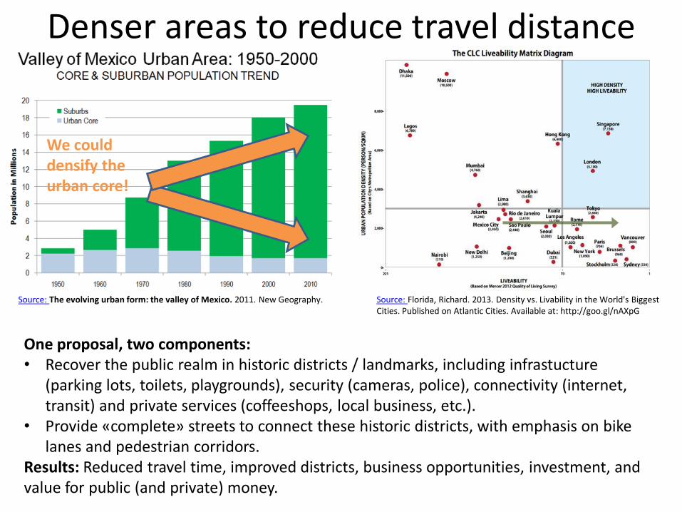
Denser areas to reduce travel distance
Source: Florida, Richard. 2013. Density vs. Livability in the World's Biggest Cities. Published on Atlantic Cities. Available at: http://goo.gl/nAXpG
Source: The evolving urban form: the valley of Mexico. 2011. New Geography.
One proposal, two components: • Recover the public realm in historic districts / landmarks, including infrastucture
(parking lots, toilets, playgrounds), security (cameras, police), connectivity (internet, transit) and private services (coffeeshops, local business, etc.).
• Provide «complete» streets to connect these historic districts, with emphasis on bike lanes and pedestrian corridors.
Results: Reduced travel time, improved districts, business opportunities, investment, and value for public (and private) money.
We could densify the urban core!

Create more micro-local areas with historic districts
• Crossing the denser part of the city is only 22km/13.7 miles on a straight line (red line). •Walking and bike lanes (3
km/1.8m lenght / blue lines) could help to connect micro-local areas, reducing congestion, noise, and air pollution.
• Instead of having only a few business /cultural districts, requiring private cars and few transit options… •We could support the
recovery of the public realm by connecting districts through walking corridors and bike lanes.
• Car average is 13 km/h (8.1m/h) •Bike lanes speed at 12
km/h (7.5 m/h). • Travel reduced to 15 min
on bike.


Affordable and easy to mantain infrastructure
Costs • Pedestrian infrastructure is
minimal, compared to those of cars. •Bike lanes are easy to
mantain. •Requires less infrastructure
(less capital and operation expenditures) than those associated with private cars. •Requires law enforcement.
Benefits • Little public works, such as
parking meters, bike lanes, and walking corridors can catalyze local investment and improve life quality, and revitalize historic districts. •Return of investment is
higher than investing on car infrastructure.
Evaluation •Districts become affordable
and accesible to all (bikes, walking, wheelchairs, strollers (baby and elderly, etc.) • Complete streets help to
recover the public realm, at a very competitive value for money, improving quality of life.

From congestion To better living conditions