pedestrian- and transit-friendly … and transit-friendly design fea-tures fall into three classes:...
TRANSCRIPT

by Reid Ewing
PEDESTRIAN-AND TRANSIT-FRIENDLY
DESIGN:A Primer for Smart Growth
Based on a manual prepared for theFlorida Department of Transportation
and published by theAmerican Planning Association

The Smart Growth Network is a coalitionof private sector, public sector, and nonprofitpartners seeking to create better neighbor-hoods, communities, and regions across theUnited States. It is coordinated by the U.S. En-vironmental Protection Agency�s Urban andEconomic Development Division.
Reid Ewing is Research Director of the Sur-face Transportation Policy Project, Washington,D.C. and Senior Associate with Fehr & PeersTransportation Consultants, Lafayette, CA.
The primer was laid out by SuzanneLambert, Multimedia Technology Programmanager at Broward Community College,Pembroke Pines, FL.
Special thanks to Tara Bartee of the FloridaDepartment of Transportation for her coop-eration and support in producing the manualupon which this primer is based.
The International City/County ManagementAssociation serves as the organizational homeof the Smart Growth Network (SGN) and runsthe SGN membership program.
For more information, contact theSmart Growth Network at 202-962-3591
or via the Smart Growth web site at www.smartgrowth.org
Table of Contents
Introduction .................................... 1
Checklist of Pedestrian- andTransit-Friendly Features ................ 2
Essential Features ........................................ 2#1 Medium-to-High Densities ................. 2
#2 Mix of Land Uses ............................. 3
#3 Short to Medium Length Blocks ..... 3
#4 Transit Routes Every Half-Mile ...... 5
#5 Two-or Four-Lane Streets (with RareExceptions) ......................................... 6
#6 Continuous Sidewalks Wide Enoughfor Couples ......................................... 6
#7 Safe Crossings .................................. 8
#8 Appropriate Buffering fromTraffic ............................................... 10
#9 Street-Oriented Buildings ................. 10
#10 Comfortable and Safe Placesto Wait .............................................. 13
Highly Desirable Features ......................... 13#11 Supportive Commercial Uses ........... 13
#12 Gridlike Street Networks .................. 13
#13 Traffic Calming along AccessRoutes ............................................... 13
#14 Closely Spaced Shade Trees alongAccess Routes .................................. 13
#15 Little Dead Space, or VisibleParking ............................................. 14
#16 Nearby Parks and Other PublicSpaces ............................................... 16
#17 Small-Scale Buildings (or ArticulatedLarger Ones) .................................... 18
#18 Classy Looking Transit Facilities ..... 18
Nice Additional Features ........................... 18#19 Streetwalls ........................................ 18
#20 Functional Street Furniture ............... 18
#21 Coherent, Small-Scale Signage ........ 18
#22 Special Pavement ............................. 20
#23 Lovable Objects, EspeciallyPublic Art .......................................... 21
Endnotes ...................................... 23

1
Urban design differs from planning in scale,orientation, and treatment of space. The scaleof design is primarily that of the street, park, ortransit stop, as opposed to the larger region, com-munity, or activity center. The orientation ofdesign is aesthetic, broadly defined. Design liessomewhere between art, whose object is beauty,and planning, whose object is functionality. Thetreatment of space in design is three-dimen-sional, with vertical elements as important ashorizontal ones in designing street space, parkspace, and other urban spaces. Planning, on the
other hand, is a singularly two-dimensional ac-tivity (as illustrated below left.)
Another primer available from the SmartGrowth Network, Best Development Practices:A Primer for Smart Growth, approaches devel-opment and redevelopment from a planning per-spective. Scant attention is paid to aesthetics,small-scale elements, and the vertical dimen-sion of development. The present primer takesthe opposite tack, giving more attention to de-
Introduction
sign than to planning. The two primers are meantto be read in tandem.
This primer is based on Pedestrian- andTransit-Friendly Design, a manual prepared forthe Florida Department of Transportation(FDOT) and the American Planning Associa-tion (APA). The primer and manual draw pri-marily on three sources�the classic urban de-sign literature, the best transit-oriented designmanuals, and our own transit-related studiesundertaken to give the manual an empirical base.
(Miami Lakes, FL)Zooming in from Planning to Design
Source: Dover & Kohl, South Miami, FL

2
Checklist of Pedestrian- and Transit-Friendly Features
Pedestrian- and transit-friendly design fea-tures fall into three classes: those deemed es-sential; those deemed highly desirable; andthose deemed nice but somewhat incidental.Even the third class will encourage street life,walking, and transit use, but for transit opera-tors, local governments, and developers, thepriorities are as indicated.
It must be acknowledged up front that sort-ing pedestrian- and transit-friendly features intothree classes involves a leap of faith. But sortwe must. Choices must be made in the align-ment of transit routes, in the amenities offeredalong walking routes, in the development prac-tices that are required rather than simply en-couraged.
From the longer list of 23 pedestrian- andtransit-friendly features in the FDOT/APAmanual, the sections that follow highlight 12.They are described in detail, and illustrated withphotos from walkable places and with graphicsreproduced from award-winning design manu-als. The other 11 features are simply acknowl-edged by name. For a detailed discussion ofthese features, see the manual upon which thisprimer is based.
The 12 highlighted features seem to relatemore to pedestrians than to transit users. Butsince virtually all transit users are pedestrians
were in the range of 40 to 80 people per acre;such densities compressed enough activitiesinto a small area to allow people to walk toalmost everything. Today, in developing ar-eas, gross densities are one-tenth the histori-cal norm. Such low densities are practical onlybecause the automobile allows us to overcomegreat distances.
People confuse high density with high rise.High densities can be achieved with small-scalebuildings by raising lot coverages to 50, 60, oreven 70 percent. Conversely, high-rise build-ings afford only moderate densities if surroundedby acres of parking and lawn. Pedestrians arecomfortable with small-scale buildings and highlot coverages. They are uncomfortable withhigh-rise towers and low lot coverages. �[M]uchof the criticism of high-rise living and its so-cially alienating effects is not due to its highdensity but to its low density at ground level,�where nearly all public interaction must occur.1
The weight of available evidence points tothe importance of density in promoting walkingand transit use.2 Higher densities mean moreresidents or employees within walking distanceof transit stops and stations. They mean morestreet life and the added interest and securitythat goes with having more people around. Theymean a greater propensity to walk or use tran-sit, and lower auto ownership rates.
at one or both ends of their trips, the distinctionis illusory. Pedestrian-friendly features are alsoinherently transit-friendly. They set the contextin which transit operates and, as transit opera-tors are discovering, have as much to do withridership as do service headways, fare levels,and other transit operating characteristics.
Interestingly, many of these 23 features arenow perceived as critical enough to the successof transit to have found their way into the newsurface transportation act, the Transportation Eq-uity Act for the 21st Century. The act earmarksfunds for bus shelters, landscaping, street fur-niture, walkways, public art, transit connectionsto parks, and other �transit enhancements.� Italso creates an entirely new program, the Trans-portation and Community and System Preser-vation Pilot Program, which provides fundingfor coordinated land use and transportation plan-ning, traffic calming, and transit-oriented de-velopment.
Essential Features
#1 Medium-to-High Densities
Densities in the United States have takena nose dive over the past 40 years. Beforemechanized transportation, gross densities

3
Low Rise with High Density vs. High Rise with Low Density at Ground Level
The old rule of thumb is that seven units peracre are required to support basic bus service.For premium bus service, the required residen-tial density rises to 15 units per acre. For railservice, it is even higher. Such high densitiesare also required for active street life and viableneighborhood businesses.
(The Kentlands, MD) (Las Colinas, TX)
As important as high residential densities,perhaps more important, are high employmentdensities. The rule of thumb in this case is that50 employees per acre are necessary to supportpremium transit service.
Ideally, the very highest densities will beclosest to transit stops. A density gradient willmaximize transit ridership. While densities maydecline with distance from stops, they will av-erage at least the threshold values within thequarter mile service area around stops.
#2 Mix of Land Uses
#3 Short to Medium Length Blocks
There has been a trend toward longer andlonger blocks, and correspondingly fewer andfewer intersections within development and re-development areas. This is true not only in thesuburbs, where superblocks are the norm, butalso in central cities where blocks plus interiorrights-of-way have been consolidated to createlarger building sites. �The practice [of block
Source: Denver Regional Council of Governments, Suburban Mobility Design Manual, Denver, CO, 1993, pp. 11-12.
Transit Productivity Thresholds (According to One Source)
Transit Ridership Maximizedby a Density Gradient
Source: Ontario Ministry of Transportation, Transit-Suppor-tive Land Use Planning Guidelines, Toronto, 1992, p. 18.
Transit
50 dwelling units/acre cansupport more bus trips thanauto trips

4
Street Maps at the Same Scale
Source: A.B. Jacobs, Great Streets, MIT Press, Cambridge, MA, 1993, pp. 221, 225, 249.
dom and control as they need not always takethe same path to a given destination; that moreintersections make a walk seem more eventful,since it is punctuated by frequent crossing ofstreets; that more intersections may shorten thesense of elapsed time on walk trips, since progressis judged to some extent against the milestone ofreaching the next intersection.5
For a high degree of walkability, blocklengths of 300 feet, more or less, are desir-able.6 Blocks of 400 to 500 feet still work well.This is typical of older urban areas. However,as blocks grow to 600 to 800 feet or, evenworse, to superblock dimensions, adjacentblocks become isolated from each other.
(Downtown Los Angeles, CA)(Venice, Italy) (Irvine, CA)
Reasons why walkability depends on blocksize are numerous. Most obviously, more inter-sections mean more places where cars must stopand pedestrians can cross. Also, short blocksand frequent cross streets create the potentialfor more direct routing; that is important to pe-destrians, much more so than to high-speedmotorists. Finally, a dense network of streetsdisperses traffic, so that each street carries lesstraffic and can be scaled accordingly; this makesstreets more pleasant to walk along and easierto cross.
There may be psychological factors at workas well. It has been suggested that more inter-sections give pedestrians more sense of free-
consolidation] contributes to a city scaled to carsand is a grave error,� assuming pedestrian-friend-liness is a goal.3
By mapping different cities at a commonscale, Allan Jacobs determined that Venice,Italy, has about 1,500 intersections in a typi-cal square mile, while the city of Irvine out-side Los Angeles, California, has 15 intersec-tions per square mile.4 Downtown Los Ange-les has about one-tenth as many intersectionsas Venice, and 10 times as many as Irvine.People familiar with these three cities woulddoubtless rank their walkability in the sameorder. Jacobs also found that downtown Bos-ton, as an example, had lost more than one-third of its intersections through block con-solidations.
5
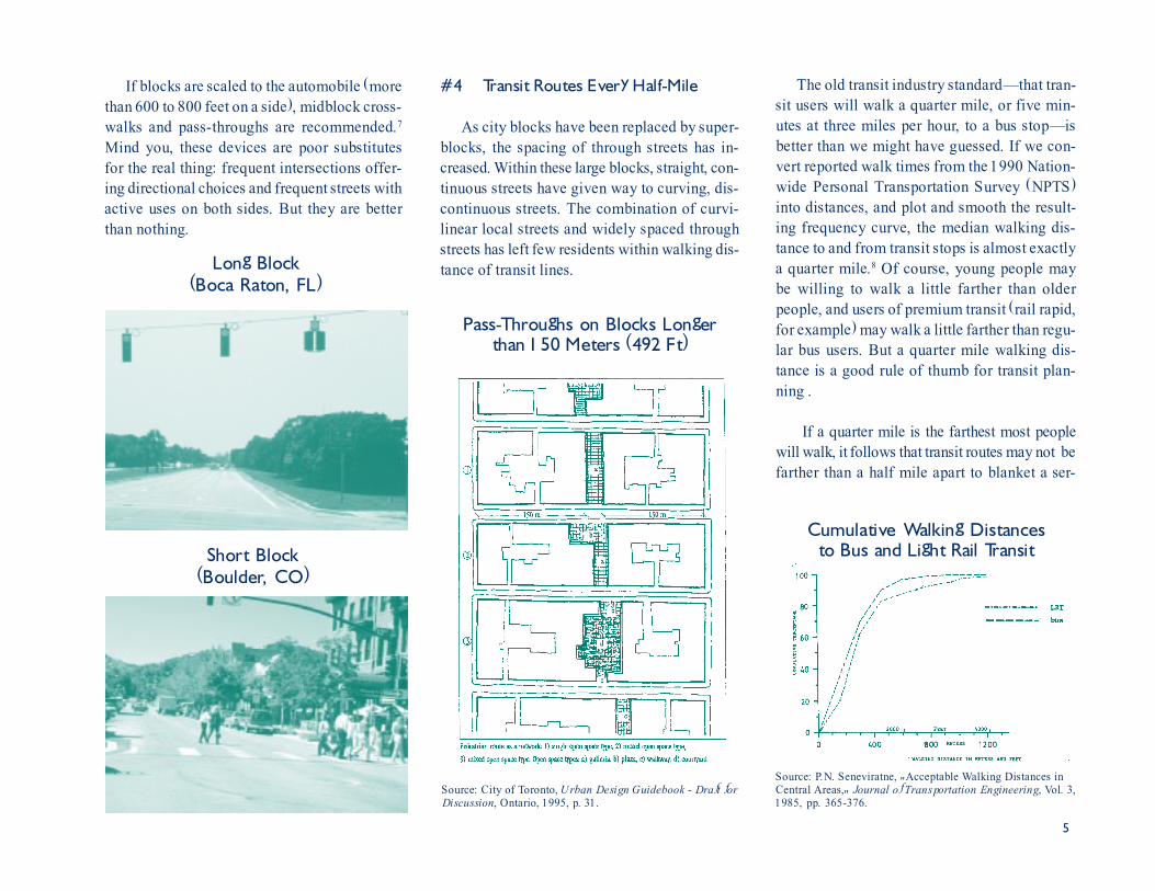
If blocks are scaled to the automobile (morethan 600 to 800 feet on a side), midblock cross-walks and pass-throughs are recommended.7
Mind you, these devices are poor substitutesfor the real thing: frequent intersections offer-ing directional choices and frequent streets withactive uses on both sides. But they are betterthan nothing.
Long Block
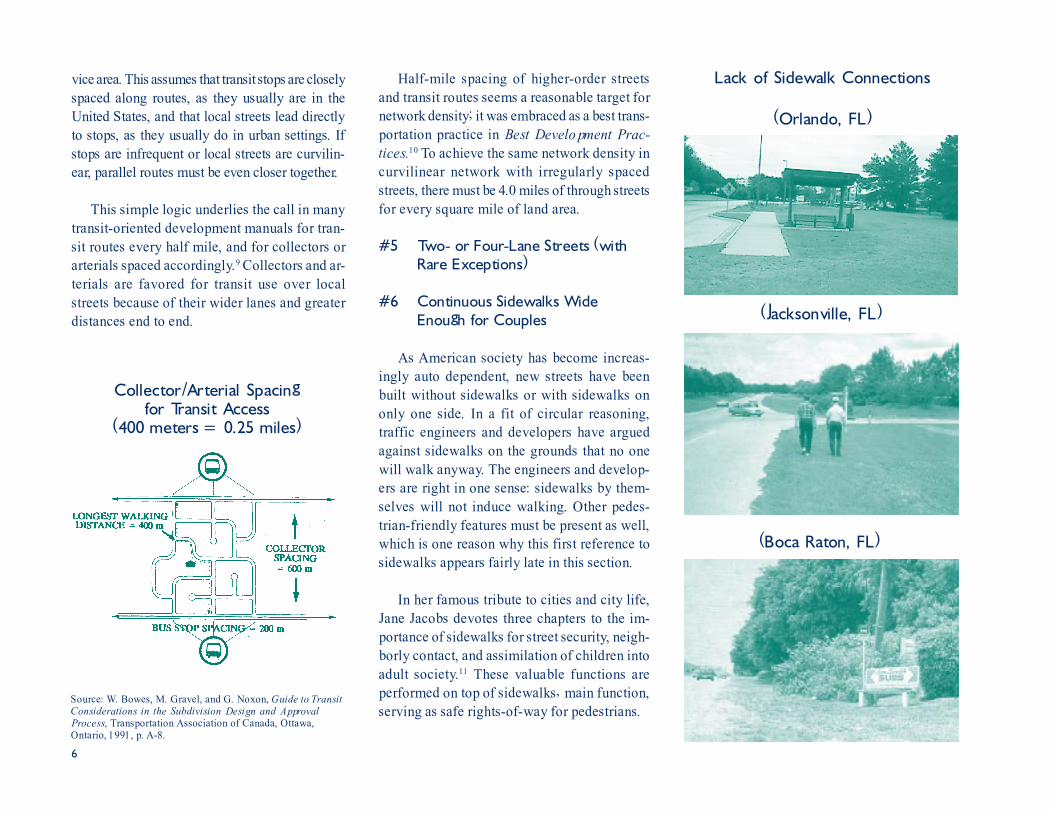
The old transit industry standard�that tran-sit users will walk a quarter mile, or five min-utes at three miles per hour, to a bus stop�isbetter than we might have guessed. If we con-vert reported walk times from the 1990 Nation-wide Personal Transportation Survey (NPTS)into distances, and plot and smooth the result-ing frequency curve, the median walking dis-tance to and from transit stops is almost exactlya quarter mile.8 Of course, young people maybe willing to walk a little farther than olderpeople, and users of premium transit (rail rapid,for example) may walk a little farther than regu-lar bus users. But a quarter mile walking dis-tance is a good rule of thumb for transit plan-ning .
If a quarter mile is the farthest most peoplewill walk, it follows that transit routes may not befarther than a half mile apart to blanket a ser-
#4 Transit Routes Every Half-Mile
As city blocks have been replaced by super-blocks, the spacing of through streets has in-creased. Within these large blocks, straight, con-tinuous streets have given way to curving, dis-continuous streets. The combination of curvi-linear local streets and widely spaced throughstreets has left few residents within walking dis-tance of transit lines.
(Boca Raton, FL)
Source: City of Toronto, Urban Design Guidebook - Draft forDiscussion, Ontario, 1995, p. 31.
Pass-Throughs on Blocks Longerthan 150 Meters (492 Ft)
(Boulder, CO)Short Block
Source: P.N. Seneviratne, "Acceptable Walking Distances inCentral Areas," Journal of Transportation Engineering, Vol. 3,1985, pp. 365-376.
Cumulative Walking Distancesto Bus and Light Rail Transit
6
vice area. This assumes that transit stops are closelyspaced along routes, as they usually are in theUnited States, and that local streets lead directlyto stops, as they usually do in urban settings. Ifstops are infrequent or local streets are curvilin-ear, parallel routes must be even closer together.
This simple logic underlies the call in manytransit-oriented development manuals for tran-sit routes every half mile, and for collectors orarterials spaced accordingly.9 Collectors and ar-terials are favored for transit use over localstreets because of their wider lanes and greaterdistances end to end.
Half-mile spacing of higher-order streetsand transit routes seems a reasonable target fornetwork density; it was embraced as a best trans-portation practice in Best Development Prac-tices.10 To achieve the same network density incurvilinear network with irregularly spacedstreets, there must be 4.0 miles of through streetsfor every square mile of land area.
#5 Two- or Four-Lane Streets (withRare Exceptions)
#6 Continuous Sidewalks WideEnough for Couples
As American society has become increas-ingly auto dependent, new streets have beenbuilt without sidewalks or with sidewalks ononly one side. In a fit of circular reasoning,traffic engineers and developers have arguedagainst sidewalks on the grounds that no onewill walk anyway. The engineers and develop-ers are right in one sense: sidewalks by them-selves will not induce walking. Other pedes-trian-friendly features must be present as well,which is one reason why this first reference tosidewalks appears fairly late in this section.
In her famous tribute to cities and city life,Jane Jacobs devotes three chapters to the im-portance of sidewalks for street security, neigh-borly contact, and assimilation of children intoadult society.11 These valuable functions areperformed on top of sidewalks� main function,serving as safe rights-of-way for pedestrians.
Source: W. Bowes, M. Gravel, and G. Noxon, Guide to TransitConsiderations in the Subdivision Design and ApprovalProcess, Transportation Association of Canada, Ottawa,Ontario, 1991, p. A-8.
Collector/Arterial Spacingfor Transit Access
(400 meters = 0.25 miles)
Lack of Sidewalk Connections
(Orlando, FL)
(Boca Raton, FL)
(Jacksonville, FL)

7
Manuals of the traffic engineering profes-sion establish minimum sidewalk widths of 4to 8 feet, depending on the functional class ofroad and the abutting land use. The state ofFlorida has adopted a standard width of 5 feet.12
A 5-foot sidewalk is wide enough for twopeople to walk comfortably abreast, and thusrepresents a good dimension where pedestriantraffic is light, street furniture is limited, andbuildings are set back from the sidewalk.13
Where these conditions are not met, as in anyrespectable downtown, wider sidewalks arewarranted.
To allow walking at near-normal speeds,sidewalks must provide at least 25 square feet
Too Empty and Too Crowded(South Miami Beach, FL)
Just as streets are scaled to vehicular trafficvolumes, so should sidewalks be scaled to pe-destrian traffic volumes. Sidewalks should bewide enough to accommodate pedestrian trafficwithout crowding, yet not be so wide as to ap-pear empty most of the time. A hint of crowd-ing may actually add to the vitality and interestof the street. It is for this reason that some ur-ban designers recommend maximum sidewalkwidths as well as minimums.
5- or 6-Foot Sidewalkfor Light Pedestrian Traffic
Source: Glatting Jackson Kercher Anglin Lopez Rinehart, Inc.,Central Florida Mobility Design Manual, Central FloridaRegional Transportation Authority, Orlando, 1994, p. 2-6.
per pedestrian at peak times.14 More space isrequired, perhaps 40 square feet per person, topermit maneuvering around slower pedestriansand complete avoidance of oncoming and cross-ing pedestrians. At 100 to 150 square feet perperson, sidewalks are still lively but give nohint of crowding.15 If strolling couples are topass one another without awkward maneuver-ing, it takes about 10 feet of clear sidewalkwidth. If street furniture (street lights, trash cans,newspaper boxes, etc.) is plentiful, an extra 2-1/2 feet of width must be allowed for clear-ance.16 If buildings run up to the sidewalk, anadditional 1 to 1-1/2 feet of width is desirabledue to the tendency of pedestrians to maintainthis clear distance from walls.17 Given suchconsiderations, it is easy to see how some lead-ing urban designers have arrived at sidewalkwidths of 10, 15, and even 20 feet as suitablefor high-volume locations.
Source: Edward D. Stone, Jr. and Associates, Riverwalk DesignGuidelines, City of Fort Lauderdale, FL, 1986, p. 3.5.
16-Foot Sidewalkfor Heavy Pedestrian Traffic

8
Sources: C. Alexander, S. Ishikawa, and M. Silverstein, A Pattern Language - Towns · Buildings · Construction, OxfordUniversity Press, New York, 1977, pp. 171 and 287; R.K. Untermann, Accommodating the Pedestrian - Adapting Towns andNeighborhoods for Walking and Bicycling, Van Nostrand Reinhold Company, New York, 1984, p. 105; S.A. Smith et al.,Planning and Implementing Pedestrian Facilities in Suburban and Developing Rural Areas - Research Report, NationalCooperative Highway Research Program Report 294A, Transportation Research Board, Washington, D.C., 1987, p. 52; W.H.Whyte, City - Rediscovering the Center, Doubleday, New York, 1988, pp. 76-78 and 93-94; P. Calthorpe, The Next AmericanMetropolis - Ecology, Community, and the American Dream, Princeton Architectural Press, New York, 1993, p. 79; and D.Sucher, City Comforts - How to Build an Urban Village, City Comforts Press, Seattle, WA, 1995, p. 142.
Alexander et al. 12 ft minimum/20 ft maximumUntermann 8-9 ft minimum/12 ft desirableSmith et al. 12-15 ftWhyte 15 ft minimum/30 ft maximumCalthorpe 15-20 ftSucher 12 ft
Recommended Sidewalk Widths at High-Volume Locations
#7 Safe Crossings
As streets have gotten wider, blocks longer,and roadway design speeds higher, street cross-ings have become treacherous. Even at suppos-edly safe signalized interactions, pedestrianscrossing with the signal are exposed to dangerfrom turning motorists. Street corners have beenrounded off; right-turn-on-red has become nearuniversal. Motorists making right turns needhardly slow down at all; they tend to look totheir left for oncoming traffic rather than theirright for crossing pedestrians. Motorists mak-ing left turns do so under protected conditionsat multiphase signals; having exclusive turn ar-rows, they tend to make turns without carefullyscanning their environment for pedestrians.
After sidewalks, the next most important pe-destrian safety feature is marked and lighted
crosswalks. Most injuries and fatalities involv-ing pedestrians occur as pedestrians attempt tocross streets, and a disproportionate number areat night.18 Accident rates are significantly lowerwhere marked crosswalks are provided andcrossings are lighted.19
Richard Untermann, a leading authority onpedestrianization, recommends marked cross-walks every 100 feet on pedestrian streets.20
To maintain such close spacing, crosswalks mustbe provided at midblock locations. While sometraffic engineers are less than enthusiastic aboutthem, midblock crosswalks have two salutaryeffects: they slow down traffic in the immedi-ate vicinity, and they discourage pedestriansfrom crossing between parked cars.21
Pedestrian crossings can be simplified, andpedestrian safety improved, by designing street
(Orlando, FL)No Midblock Crosswalk
(Orlando, FL)Midblock Crosswalk
(Williamsburg, VA)Midblock Crosswalk with Refuge Island

9
corners to be sharp rather than rounded. His-torically, corners at intersections had radii ofonly 2 to 5 feet; they are now 25 to 50 feet,often more. Untermann advocates a return tocorner radius of only 5 to 10 feet on streets withcurbside parking; with curbside parking, vehiclesturning from the travel lane have an effectivecorner radius much larger than 5 to 10 feet.22
Crossing Distances vs. Corner Radii Turning Speeds vs. Corner Radii
Source: American Association of State Highway and Transportation Officials, A Policy on Geometric Design of Highways andStreets, Washington, D.C., 1990, pp. 197, 714.
Large Corner Radiusin a Contemporary Development
Small Corner Radius in aTraditional Town(Dade City, FL)
(Orlando, FL)
He also recommends a 5- to 10-foot radius onlow-volume residential streets without parkinglanes; the occasional service or emergency ve-hicle can swing wide into the opposing travellane when traffic is light.
The smaller corner radii shorten crossing dis-tances for pedestrians (see first figure). Theyalso compel motorists to slow down as they ne-gotiate corners (see second figure). And theydiscourage dangerous rolling stops.
Pedestrian crossings can be further simpli-fied, and pedestrian safety enhanced, by flaringsidewalks at intersections and midblock cross-walks. This is the exact opposite of what is usu-ally done at intersections; corners are usuallycut back to make room for turning vehicles.Sidewalks flared in this manner form safecrosses. Safe crosses reduce crossing distancesand make waiting pedestrians more visible tomotorists.
Sidewalks Flared to Form Safe Crosses
Source: City of Toronto, Urban Design Guidebook - Draft forDiscussion, Ontario, 1995, p. 25.

10
Safe crosses are nothing more than neck-downs, chokers, or whatever you choose to callthem, combined with crosswalks. When com-bined with speed tables (raised to the level ofsidewalks), crosswalks form what are sometimescalled raised crossings or plateaus, powerful traf-fic calming devices placed where they will dothe most good for pedestrians.
#8 Appropriate Buffering from Traffic
#9 Street-Oriented Buildings
The growing dominance of the automobilehas been accompanied by changes in architec-ture and site planning that cause buildings torelate poorly to streets. Buildings have spreadout rather than up, stepped back from the street,and had their windows and doors reduced innumber, reoriented away from the street, orglazed over.
These changes have minimal effect on mo-torists as they whiz by. But pity the poor pedes-trian, who has less to look at, feels more iso-lated, and has farther to go to reach any desti-nation. Important urban design qualities havebeen lost in the process, including accessibility,safety, visual enclosure, and transparency/hu-man presence.
As a convenient rule of thumb, buildingsshould be set back no farther than 25 feet fromthe street edge, for beyond that they lose theirtangible connection to the street.23 Ideally,buildings will be flush with the sidewalk or setback just far enough for a modest yard,forecourt, or landscaped area in front. Surfaceparking will be to the side or rear of buildings;parked cars should not dominate the streetscapeby projecting beyond adjacent building fronts.If any off-street parking is allowed in front,and it is best not to allow any, it should be nodeeper than a row or two.
The principle of visual enclosure can be usedto fine tune building setbacks. Visual enclosureof streetscapes occurs when bordering build-ings are tall enough in relation to street widthto block most of a pedestrian�s cone of vision.The term �outdoor room� is sometimes appliedto streetscapes that are so visually enclosed as
Raised Crossing(Eugene, OR)
Source: Denver Regional Council of Governments, Suburban Mobility Design Manual, Denver, CO, 1993, p. 29.
Street for Pedestrians with Parking in Back
Street for Automobiles with Parking in Front
Safe Cross(San Luis Obispo, CA)

11
to be roomlike. The �walls� of the room are thevertical elements that bound and shape streetspaces, usually buildings.
By making a street more roomlike, we alsomake it more pedestrian-friendly. People likerooms; they relate to them daily in their homesand work places, and feel comfortable and se-
(San Diego, CA)
(Davis, CA)
(Santa Barbara, CA)
Strong Connections to the StreetThanks to Small Setbacksand Building Projections
cure in them. Drivers respond to the sense ofenclosure by slowing down, making the streetthat much more pedestrian-friendly.24
The experts disagree on exactly what height-to-width ratio is desirable for a sense of enclo-sure and intensely experienced three-dimensionalspace (see the height-to-width table to left).
Height-to-Width Ratiosfor Street Enclosure
Alexander et al. 1:1 ideal
Hedman 1:1 - 1:2 ideal
Lynch and Hack 1:4 minimum1:2 - 1:3 ideal
Duany and 1:6 minimumPlater-Zyberk
A. Jacobs 1:2 minimum1:1 ideal
Sources: C. Alexander, S. Ishikawa, and M. Silverstein, APattern Language - Towns · Buildings · Construction,Oxford University Press, New York, 1977, p. 490; R.Hedman, Fundamentals of Urban Design, AmericanPlanning Association, Chicago, IL, 1984, pp. 58-59; K.Lynch and G. Hack, Site Planning, MIT Press, Cambridge,MA, 1984, p. 158; A. Duany and E. Plater-Zyberk, �TheSecond Coming of the American Small Town,� WilsonQuarterly, Vol. 16, 1992, pp. 19-48; and A.B. Jacobs,Great Streets, MIT Press, Cambridge, MA, 1993, p. 280.
About Right Enclosure(San Diego, CA)
Too Little Enclosure(Sarasota, FL)
(according to different experts)

12
suburban shopping centers, office towers setback behind urban plazas, or any similar build-ing arrangements. It simply means that in suchcases, outbuildings must be placed along thestreet to create strong, positive corners and rea-
A common rule of thumb is that viewers shouldnever be farther away from the defining streetedge than three times the enclosure height; thisimplies a minimum height-to-width ratio of 1:3.
If we take a residential street with a 30-footright-of-way and place 20-foot high dwellingsalong it (spaced side by side to create a con-tinuous streetscape), the maximum front set-back for a 1:3 height-to-width ratio is 15 feet.If we take a commercial street with 60-foot right-of-way and place 20-foot storefronts along it,they must sit directly on the right-of-way line.
As streets get wider, bordering buildingsmust rise to contain street space; at some point,even tall buildings will not do the job. Streettrees must take over as imperfect substitutes.Or street vistas must be terminated by strongmarkers such as monuments or prominent build-ings; spatial definition is thus achieved bymeans of focal points rather than enclosure.
The other requirements for street-orientedbuildings are that main entries face the street,and that windows, in significant numbers, be atstreet level. For security and transparency, build-ings cannot turn their backs or blank sides tothe street.25 The best streets are replete withdoors and windows.26
This plea for street-oriented buildings doesnot preclude stores set back from the street in
Mall Intensified through the Addition of Outbuildings
Source: P. Calthorpe, The Next American Metropolis - Ecology, Community, and the American Dream, Princeton Architectural Press,New York, 1993, p. 111.
Shopping Center Redesigned to Connect to the Street
Source: Snohomish County Transportation Authority, A Guide to Land Use and Public Transportation�Volume II: Applying theConcepts, Lynnwood, WA, 1993, pp. 2-2 and 2-3.
sonably continuous streetscapes. Even regionalshopping malls with inner courtyard space canbe designed with a secondary street orientation.Malls can extend to the street on one or moresides, stores can have separate entrances and

13
display areas facing the street, and, if neces-sary, service corridors and loading docks can beprovided within the mall itself.27
#10 Comfortable and Safe Places to Wait
(end of Essential Features)
Highly Desirable Features
#11 Supportive Commercial Uses
#12 Gridlike Street Networks
#13 Traffic Calming along Access Routes
#14 Closely Spaced Shade Trees alongAccess Routes
If the �right� trees are planted at the �right�spacing in the �right� locations, they contributeto nearly all pedestrian-friendly design objec-tives. These include comfort/safety, human scale,linkage, visual enclosure, complexity, coherence,and sense of place.
Generally, the right trees are shade trees thatwill grow to 50 to 70 feet at maturity and have acanopy starting at a comfortable 15 feet or soabove the ground. In a place like Miami, shadeis always required, and wind often required, foroutdoor comfort.28 The constant movement ofbranches and leaves, and the ever-changing pat-terns of light created, add to the visual com-plexity of the streetscape. The low canopy con-trasts with the monumentality of wide spaces
(Davis, CA)
(Santa Barbara, CA)
Street Trees SpacedLess Than 30 Feet Apart
and tall buildings, creating human scale withinlarger volumes.
The right spacing of trees places them closeenough together to form a continuous canopyover the sidewalk and a buffer between streetand sidewalk. This requires spacing of 30 feetor less center to center, not the 50 to 70 feetcalled for in land development codes. When treesare first planted, they must be close together todefine street space at all. As they mature overdecades, closely spaced trees will have higher,more translucent canopies that produce an un-interrupted quality of light and shade. Nearlyall the streets cited as outstanding examples byHenry Arnold in his insightful book, Trees inUrban Design, have street trees no more than30 feet apart.29
The right location for street trees is between
the street and the sidewalk, as close to the curbas engineering standards permit. Trees plantedbetween the street and sidewalk provide a physi-cal and psychological barrier between large-mass vehicles and small-mass pedestrians. Inthis location, trees visually limit street space,thereby calming traffic; they extend pedestrianspace from buildings to the street; and they shade
Trees Mediating Scale of High-Rise Offices
( Miami, FL)

14
the entire right-of-way, both street and side-walk.30
The standard suburban practice is just the op-posite of what is recommended here. Small orna-mental and flowering trees, fruit trees, and palmssubstitute for substantial shade trees. They areplaced far apart and set on the far (building) side
of the sidewalk, where they pose less risk to er-rant vehicles. It is a perverse world, indeed, whereerrant vehicles are afforded more protection fromtrees than pedestrians are from errant vehicles.Used thus, trees may decorate a street or screenan unpleasant view, but contribute little to the fun-damentals of good design, such as spatial defini-tion and pedestrian safety.
#15 Little Dead Space, or Visible Parking
Designers promote active street-level landuses with fervor. Inactive uses, those generat-ing few pedestrian trips, are avoided like theplague. Inactive uses create dead street spaces.
Parking lots have become the principalsource of dead space in cities. No less author-ity than William H. Whyte considers them worsethan blank walls.31 Parking lots crowd out ac-tive uses, leaving people with less reason tocome to an area and park in the first place.Empty metal shells and expanses of flat blackasphalt are less interesting than almost anybuilding imaginable.
Nine percent is said to be the upper limit onthe amount of land area devoted to parking;beyond that, people sense that the environmentis no longer theirs but rather belongs to auto-mobiles.32 Downtown pedestrian counts in smallcities fall as the amount of open parking in-creases.33 None of the Great Streets featured inthe book by that name has an abundance ofparking, either off street or on.34
To meet the nine percent target, or comeclose, it is necessary to:
� set maximums on the amount ofparking supplied by developers, notjust minimums as in most landdevelopment codes;
� give credit for curb-side parkingagainst the amount of off-streetparking required;
Tree Row Expanding Motorists�Psychological Space (Coral Springs, FL)
Tree Row Limiting Motorists� Psychological Space(Ft. Lauderdale, FL)
Dead Spaces
(West Palm Beach, FL)
(Boston, MA)

15
Examples of enlightened parking policiescan be found around the United States. Guid-ance in devising such policies is available frommany sources.35
Where surface parking remains after suchpolicies are adopted, it should be placed be-hind buildings (the best) or to the side (the sec-ond best). If placed in front, surface parkingshould be limited to a row or two to preservethe street orientation of buildings. PeterCalthorpe recommends that parking lots occupyno more than one third of the frontage alongpedestrian-oriented streets, and no more than75 feet in a stretch.36 Even these figures maybe too high for pedestrian streets.
While parking lots have the potential to bealmost park- or plaza-like, it happens so sel-dom in practice that screening parking withwalls, hedges, or berms is advisable along publicstreets. If low and articulated, such screensform a nice street edge that is both complexand transparent.
The other major source of dead space incities is blank walls�windowless or reflectiveglass building facades, garage-dominated resi-dential streets, and flat security walls. Whileblank walls can define and enclose space, theresulting space is characterless. It takes archi-tectural details, surface textures, modulation oflight and shade, or changes in color to inject lifeinto space and hold pedestrian interest.37
reduce the amount of parking re-quired whenever land uses withdifferent peaking patterns shareparking lots;
� substitute parking garages for surfaceparking lots; and/or
� build satellite parking facilities to freepedestrian streets from heavy parkingdemands.
Parking Limited to a Row or Twoin Front of Buildings
Source: M.L. Hinshaw and Hough Beck & Baird, Inc., DesignObjectives Plan: Entryway Corridors - Bozeman, Montana,1992, p. 42.
Parking Placed to the Side of Buildings
Source: M.L. Hinshaw and Hough Beck & Baird, Inc., DesignObjectives Plan: Entryway Corridors - Bozeman, Montana,1992, p. 43.
Source: City of San Bernardino, Calif., Title 19 - City of SanBernardino Municipal Code, 1991, p. II-145.
Articulated and Landscaped Wallsand Wall-Fence Combinations
Wall That Screens Parkingwithout Spoiling the Street Edge
(Mount Dora, FL)
Whyte has toyed with the idea of calculatinga �blank wall index� for urban places, equal tothe percentage of blank walls up to 35 feet abovestreet level.38 If such an index were devised andmeasured over space and time, it would be high

16
in cities, even higher in suburbs, and on therise everywhere. Instead, downtowns and mainstreets should have at least 50 percent of theirground-floor frontage devoted to retail uses,and all glass fronts should be of the see-through variety.39 Where blank walls are un-avoidable, they should be articulated and/orsoftened with plantings.
Parking garages, desirable in other respects,add to the blank wall index of cities. They
should be disguised to look like neighboringbuildings, with the same proportions of verticaland horizontal elements and with the same build-ing materials. Or they should be hidden behindtrees and other landscaping so their appearancebecomes less problematic. For added interest,parking garages can have retail outlets at streetlevel or retail display cases in their stead.
#16 Nearby Parks and Other PublicSpaces
Nearby parks and other public spaces (play-grounds, plazas, gardens, squares, etc.) serve asattractions for pedestrians. People are more likelyto walk when they have some place specific,and nearby, to go. �Around the block,� or thesubdivision, is a poor substitute for a real desti-nation.
Public spaces contribute more to the streetenvironment when they appear as extensions ofstreet and sidewalk rather than as stand alones.If a good pedestrian street is an outdoor room,then a good park, playground, or plaza is an-other room just off the main room, or an alcovewithin the main room.
Used in this manner, public spaces punctu-ate the street network, break up long stretches,and grace streets with beginnings and endings.They give the streets upon which they sit a spe-cial character, something lacking in modernstreet networks.40 They add complexity, legibil-ity, and sense of place to the street environment.
Parking Neatly Hidden(San Diego, CA)
(Atlanta, GA)
William H. Whyte�s study of plazas in NewYork shows just how important connections tothe street and sidewalk can be. Well-connectedplazas generate a substantial amount of impulseuse. Sunken or elevated plazas do not. �If peopledo not see a space, they will not use it.�41
(Winter Park, FL)
Parks and Plazas as Extensions of Main Streets(Palo Alto, CA)

17
Public spaces also contribute more to thestreet environment when they draw on a vari-ety of land uses nearby rather than only one. Asingle dominant use produces patrons with simi-lar schedules (mothers in mid-afternoon, officeworkers at lunch time). Nearby spaces are de-populated at other hours.
Best Development Practices offers designguidelines for parks and other public spaces.43
Among them: Spaces should be highly acces-sible to pedestrians, linked to other spaces viasight lines, and crammed with activities and sen-suous elements: trees, water, sculpture, etc.
Generalized spaces, without any particulardraw of their own, are populated naturally onlywhere life swirls nearby.42 There is particularsynergism with shopping. Shoppers and othervisitors animate public spaces, and public spacesin turn cause people to linger. Spaces can be assmall as a flared corner or a recessed buildingentry equipped with a bench and shade tree. Infact, some of the most valued and heavily usedspaces are the smallest. A hint of crowding mayactually enhance appeal and festive character.
Plaza Created by Flaring a SidewalkAlong a Shopping Street
(Hollywood, FL)
Source: P. Calthorpe, The Next American Metropolis -Ecology, Community, and the American Dream, PrincetonArchitectural Press, New York, 1993, p. 92.
Small Park SupportingMultiple Activities
Source: Edward D. Stone, Jr. and Associates, Riverwalk DesignGuidelines, City of Fort Lauderdale, Fla., 1986, p. 2.2.
Public Space Accessiblefrom Several Directions
Source: City and County of San Francisco, Mission Bay Plan -Proposal for Adoption, 1990.
Public Spaces Linked to One Another
Plaza Built into aConventional Shopping Center
(Boca Raton, FL)

18
#17 Small-Scale Buildings (or ArticulatedLarger Ones)
#18 Classy Looking Transit Facilities
(end of Highly Desirable Features)
Nice Additional Features
#19 Streetwalls
#20 Functional Street Furniture
#21 Coherent, Small-Scale Signage
In traditional cities, buildings dominatestreetscapes with their strong vertical lines andcloseness to the street; landscaping and signageare secondary. In suburbs and suburb-like cit-ies, roles are reversed. Buildings are so low,and are set so far back, that landscaping and
signage become dominant image makers. Theimages created by suburban landscaping are gen-erally positive, if a bit monotonous. The imagescreated by signage are usually negative. �In theircompetition for the attention of the motoring pub-lic, merchants continually push the roadside vi-sual envelope to its breaking point by erectingbigger, taller, and brighter signs.�44
Local governments and large-scale devel-opers have responded to the proliferation of gar-ish highway signs by regulating the number,type, and size of signs. But while avoiding thechaos of the commercial strip, the result of zeal-ous sign regulation can be almost as bad. Signscan cease to convey information effectively orto convey a sense of community character. Theycan be so standardized as to be tedious.
Kevin Lynch and other top designers haverecognized the creative possibilities afforded by
good signage.45 If designed and applied thought-fully, signs can add several pedestrian-friendlyqualities to streetscapes: human scale, complex-ity, coherence, and sense of place.
The best signs convey a sense of place, ei-ther the place of business they advertise or thedistrict in which it is located.49 The most memo-rable places in Florida have signage to match:South Beach in Miami, Sanibel Island, Park Av-enue in Winter Park, and other tourist meccas.Signs add to the fun and novelty of being there.
(Fast Food in Las Vegas, NV)Pushing the Envelop in Both Directions
(Fast Food in Key West, FL)
Memorable Signs, Memorable Places
(South Miami Beach, FL)
(Santa Barbara, CA)
19
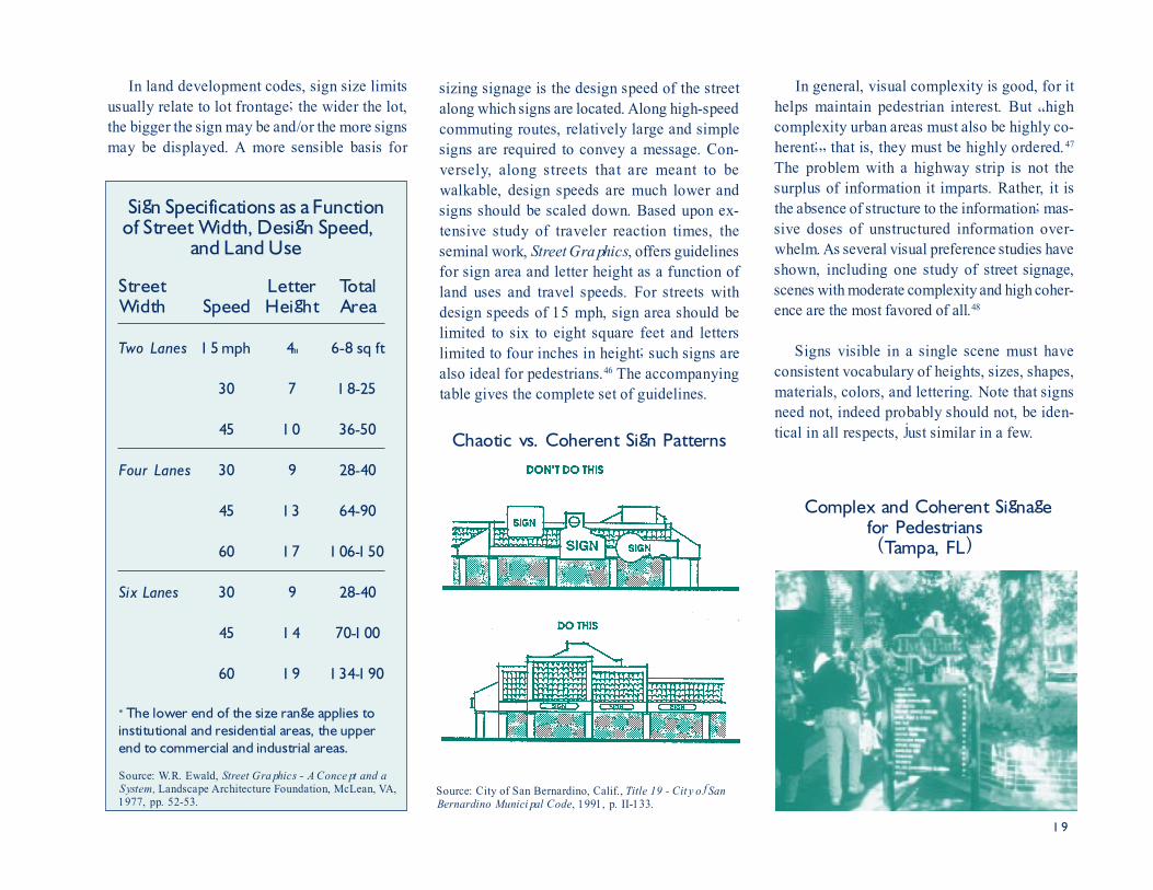
In land development codes, sign size limitsusually relate to lot frontage; the wider the lot,the bigger the sign may be and/or the more signsmay be displayed. A more sensible basis for
In general, visual complexity is good, for ithelps maintain pedestrian interest. But �highcomplexity urban areas must also be highly co-herent;� that is, they must be highly ordered.47
The problem with a highway strip is not thesurplus of information it imparts. Rather, it isthe absence of structure to the information; mas-sive doses of unstructured information over-whelm. As several visual preference studies haveshown, including one study of street signage,scenes with moderate complexity and high coher-ence are the most favored of all.48
Signs visible in a single scene must haveconsistent vocabulary of heights, sizes, shapes,materials, colors, and lettering. Note that signsneed not, indeed probably should not, be iden-tical in all respects, just similar in a few.
sizing signage is the design speed of the streetalong which signs are located. Along high-speedcommuting routes, relatively large and simplesigns are required to convey a message. Con-versely, along streets that are meant to bewalkable, design speeds are much lower andsigns should be scaled down. Based upon ex-tensive study of traveler reaction times, theseminal work, Street Graphics, offers guidelinesfor sign area and letter height as a function ofland uses and travel speeds. For streets withdesign speeds of 15 mph, sign area should belimited to six to eight square feet and letterslimited to four inches in height; such signs arealso ideal for pedestrians.46 The accompanyingtable gives the complete set of guidelines.
Sign Specifications as a Function of Street Width, Design Speed,
and Land Use
Street Letter TotalWidth Speed Height Area
Two Lanes 15 mph 4" 6-8 sq ft
30 7 18-25
45 10 36-50
Four Lanes 30 9 28-40
45 13 64-90
60 17 106-150
Six Lanes 30 9 28-40
45 14 70-100
60 19 134-190
* The lower end of the size range applies toinstitutional and residential areas, the upperend to commercial and industrial areas.
Source: W.R. Ewald, Street Graphics - A Concept and aSystem, Landscape Architecture Foundation, McLean, VA,1977, pp. 52-53.
Source: City of San Bernardino, Calif., Title 19 - City of SanBernardino Municipal Code, 1991, p. II-133.
Chaotic vs. Coherent Sign Patterns
Complex and Coherent Signagefor Pedestrians
(Tampa, FL)

20
#22 Special Pavement
When streets are conceived as outdoorrooms, the �walls� of the room are the build-ings that bound and shape the street. The �ceil-ing� is the sky itself, which if bordering build-ings are roughly the same height and close to-gether, will be perceived as a ceiling throughthe power of suggestion. The �floor� is the streetand sidewalk surface.
How important is the floor�its color, tex-ture, and pattern�in making a street space feelmore roomlike? On this the best minds dis-agree.50 Special paving can contribute somethingto at least four qualities of pedestrian-friendlydesign: human scale, linkage, complexity, andcoherence. Its contribution is necessarily lim-ited, however, by the oblique angle at whichpedestrians view pavement receding into the dis-tance; any pattern quickly becomes indiscern-
ible. Bricks, cobbles, precast pavers, and pat-terned concrete cannot compensate for other-wise poorly defined street space. And they arerelatively expensive as streetscape improve-ments go.51 Elaborate pavement is as expen-sive as large, closely spaced trees and has muchless visual impact.
Thus, special paving is probably best usedas an accent rather than as fill-in material,
(Reston, VA) (Seattle, WA)Use of Textured Surfaces for Intensive Traffic Calming
Use of Textured Surfaces as Warning Devices(Santa Barbara, CA)(Miami Lakes, FL)
Poor Street Space DespiteStreetscape Improvements
(Miami, FL)
and used mainly where it serves some pur-pose other than a purely decorative one. Traf-fic calming is one such purpose. Used in a�gateway� entering a pedestrian zone, or in acrosswalk, textured pavement warns driversto slow down and look out for pedestrians.For intensive traffic calming, an entire streetsection may be specially paved.
21
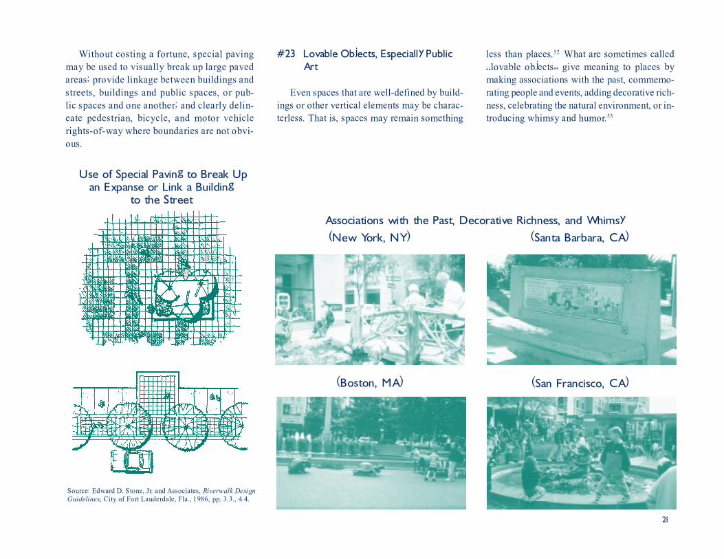
less than places.52 What are sometimes called�lovable objects� give meaning to places bymaking associations with the past, commemo-rating people and events, adding decorative rich-ness, celebrating the natural environment, or in-troducing whimsy and humor.53
#23 Lovable Objects, Especially PublicArt
Even spaces that are well-defined by build-ings or other vertical elements may be charac-terless. That is, spaces may remain something
Without costing a fortune, special pavingmay be used to visually break up large pavedareas; provide linkage between buildings andstreets, buildings and public spaces, or pub-lic spaces and one another; and clearly delin-eate pedestrian, bicycle, and motor vehiclerights-of-way where boundaries are not obvi-ous.
Use of Special Paving to Break Upan Expanse or Link a Building
to the Street
Source: Edward D. Stone, Jr. and Associates, Riverwalk DesignGuidelines, City of Fort Lauderdale, Fla., 1986, pp. 3.3., 4.4.
(New York, NY) (Santa Barbara, CA)Associations with the Past, Decorative Richness, and Whimsy
(Boston, MA) (San Francisco, CA)

22
Focal Points at Ends Compensatingfor Weakly Defined Street Space
Source: J.B. Goldsteen and C.D. Elliott, Designing America:Creating Urban Identity, Van Nostrand Reinhold, New York,1994, p. 171.
(Stuart, FL)Public Art Terminating a Street Vista
(Madison, FL)Public Art Centering a Village Green
Public Art Integratedinto a Bus Stop
(Orlando)
Source: Herbert - Halback, Inc., Lynx - Customer AmenitiesManual, Central Florida Regional Transportation Authority,Orlando, 1994, pp. 4.8,5.3.
Place Makers - Public Art That Tells YouWhere You Are profiles dozens of artworks thathelp define and enrich public places. The bookdefines public art broadly, as it should. Amongthe works it profiles are sculpture, murals, deco-ratively shaped fountains, inlaid pavements, andmosaic-covered benches.54 Anecdotal evidencesuggests that introducing public art�art in pub-lic places�can increase pedestrian activity.55
Public art has this power because it is not justartistic, like art in private collections. It is place-making.
If public art is sufficiently monumental, itcan overcome a fragmented frame of buildingsthat, by itself, could not contain space. The artmust have a vertical thrust to serve as a marker,and an open design to grasp and hold the spacearound it.56 This principle applies both to streets,whose end points can be marked with publicart, and to parks and other public spaces, whosecenters can be defined by public art.
23
1 P. Newman and T. Hogan, �A Review of Urban Den-sity Models: Toward a Resolution of the Conflict betweenPopulace and Planner,� Human Ecology, 9, 1981, pp.269-303.
2 H.S. Levinson and F.H. Wynn, �Effects of Density onUrban Transportation Requirements,� Highway ResearchRecord 2, 1963, pp. 38-64; K. Neels et al., An EmpiricalInvestigation of the Effects of Land Use on Urban Travel,The Urban Institute, Washington, D.C., 1977, pp. 60-66; G. Harvey, Relation of Residential Density to VMTPer Resident, Metropolitan Transportation Commission,Oakland, CA, 1990; R.J. Spillar and G.S. Rutherford,�The Effects of Population Density and Income on PerCapita Transit Ridership in Western American Cities,�ITE 1990 Compendium of Technical Papers, Institute ofTransportation Engineers, Washington, D.C., 1990, pp.327-331; J. Holtzclaw, Explaining Urban Density andTransit Impacts on Auto Use, Sierra Club, San Francisco,1991, pp. 18-24; P.W.G. Newman and J.R. Kenworthy,Cities and Automobile Dependence: A Sourcebook,Gower Technical, Brookfield, VT, 1991, pp. 34-68; R.Cervero, �Rail-Oriented Office Development in Califor-nia: How Successful?� Transportation Quarterly, Vol.48, 1994, pp. 33-44; L.D. Frank and G. Pivo, �Impactsof Mixed Use and Density on the Utilization of ThreeModes of Travel: Single-Occupant Vehicle, Transit, andWalking,� Transportation Research Record 1466, 1994,pp. 44-52; L.D. Frank and G. Pivo, Relationships be-tween Land Use and Travel Behavior in the Puget SoundRegion, Washington State Department of Transportation,Seattle, WA, 1994, pp. 14-34; J. Holtzclaw, Using Resi-dential Patterns and Transit to Decrease Auto Depen-dence and Costs, Natural Resources Defense Council,San Francisco, CA, 1994, pp. 20-21; R. Kitamura, P.L.Mokhtarian, and L. Laidet, �A Micro-Analysis of LandUse and Travel in Five Neighborhoods in the San Fran-cisco Bay Area,� Paper presented at the 74th AnnualMeeting, Transportation Research Board, Washington,D.C., 1994.
3 D. Sucher, City Comforts - How to Build an UrbanVillage, City Comforts Press, Seattle, WA, 1995, p. 131.
4 A.B. Jacobs, Great Streets, MIT Press, Cambridge, MA,1993, pp. 260-262.
10 For a more complete discussion, see R. Ewing, BestDevelopment Practices - Doing the Right Thing and Mak-ing Money at the Same Time, American Planning Asso-ciation, Chicago, IL, 1996.
11 J. Jacobs, The Death and Life of Great American Cit-ies, Random House, New York, 1961, pp. 29-88.
12 Florida Department of Transportation, Florida Pedes-trian Safety Plan, Tallahassee, 1992, pp. II-3 and II-4.
13 J.H. Allen, �Engineering Pedestrian Facilities,� in Get-ting There by All Means: Interrelationships of Transpor-tation Modes, 8th International Pedestrian Conference,City of Boulder, CO, 1987, pp. 213-222.
14 J.J. Fruin, Pedestrian Planning and Design, Metro-politan Association of Urban Designers and Environmen-tal Planners, Inc., New York, 1971, pp. 42 and 47-50.
15 A. Jacobs, p. 273; and B. Pushkarev and J.M. Zupan,Urban Space for Pedestrians, MIT Press, Cambridge,MA, 1975, pp. 127-129; C. Alexander et al., A NewTheory of Urban Design, Oxford University Press, NewYork, 1987, pp. 170-171 and 596-598.
16 Pushkarev and Zupan, pp. 151-152.
17 Fruin, p. 44.
18 National Safety Council, Accident Facts, Chicago, IL,1993, pp. 55, 69.
19 R.L. Knoblauch et al., pp. 38-50.
20 Untermann, 1984.
21 W.G. Berger, Urban Pedestrian Accident Countermea-sures Experimental Evaluation - Volume 1 - BehavioralEvaluation Studies, National Highway Safety Adminis-tration and Federal Highway Administration, Washing-ton, D.C., 1975, pp. 3-25 through 3-32.
22 Untermann, 1984, pp. 103 and 180-181.
23 O. Newman, Community of Interest, Anchor Press/Doubleday, Garden City, NY, 1980, p. 171.
Endnotes5 Sucher, p. 131; and R.K. Untermann, Accommodatingthe Pedestrian - Adapting Towns and Neighborhoods forWalking and Bicycling, Van Nostrand Reinhold, NewYork, 1984, p. 27.
6 A. Jacobs, p. 302; Sucher, p. 131; and W.H. Whyte,City - Rediscovering the Center, Doubleday, New York,1988, pp. 317-319.
7 S.A. Smith et al., Planning and Implementing Pedes-trian Facilities in Suburban and Developing Rural Ar-eas - Research Report, National Cooperative HighwayResearch Program Report 294A, Transportation ResearchBoard, Washington, D.C., 1987, p. 25; R.L. Knoblauchet al., Investigation of Exposure Based Pedestrian Acci-dent Areas: Crosswalks, Sidewalks, Local Streets andMajor Arterials, Federal Highway Administration, Wash-ington, D.C., 1988, p. 54; and Post, Buckley, Schuh &Jernigan and J. Fruin, Recommended Design Standardsfor the Florida Pedestrian Design Standards Develop-ment Study, Florida Department of Transportation, Tal-lahassee, 1988, p. 32. The City of Toronto is contem-plating an even stricter standard - a maximum blocklength of 150 meters (492 ft) before midblock pass-throughs are required. Planning and Development De-partment, Urban Design Guidebook, City of Toronto,October 1995 draft, p. 31.
8 Travel distances were estimated assuming everyonewalked at the National Personal Transportation Surveyaverage speed of 3.16 mph. Curves were smoothed toaccount for people�s tendency to round off travel times.
9 Snohomish County Transportation Authority, A Guideto Land Use and Public Transportation, TechnologySharing Program, U.S. Department of Transportation,Washington, D.C., 1989, p. 7-6; W. Bowes, M. Gravel,and G. Noxon, Guide to Transit Considerations in theSubdivision Design and Approval Process, Transporta-tion Association of Canada, Ottawa, Ontario, 1991, p.A-8; Ontario Ministry of Transportation, Transit-Support-ive Land Use Planning Guidelines, Toronto, 1992, pp.45-46; and Denver Regional Council of Governments,Suburban Mobility Design Manual, Denver, CO, 1993,p. 26.

24
24 D.T. Smith and D. Appleyard, Improving the Residen-tial Street Environment, Federal Highway Administration,Washington, D.C., 1981, pp. 123-130.
25 J. Jacobs, p. 35.
26 A. Jacobs, pp. 285-287.
27 See for successful examples, see T. Fisher, �Remak-ing Malls,� Progressive Architecture, 69, November 1988,pp. 96-101; D. Schwanke, T.J. Lassar, and M. Beyard,Remaking the Shopping Center, Urban Land Institute,Washington, D.C., 1994, pp. 31-59; I.F. Thomas, �Re-inventing the Regional Mall,� Urban Land, 53, Febru-ary 1994, pp. 24-27; and T. Lassar, �Shopping CentersCan Be Good Neighbors, Planning, 61, October, 1995,pp. 14-19.
28 A bioclimatic chart relates human comfort to fourmajor climate variables � temperature, relative humid-ity, sunlight, and wind. For an introduction to this sub-ject, see G.Z. Brown, Sun, Wind, and Light - Architec-tural Design Strategies, John Wiley & Sons, New York,1985, pp. 33-35 and 50-51.
29 H.F. Arnold, Trees in Urban Design, Van NostrandReinhold, New York, 1993, pp. 173-181.
30 Arnold, p. 56.
31 Whyte, pp. 314-315.
32 Alexander et al., pp. 120-125.
33 J.B. Kenyon, �A Model of Downtown Pedestrian Gen-eration,� in Getting There by All Means: Interrelation-ships of Transportation Modes, 8th International Pedes-trian Conference, City of Boulder, CO, 1987, pp. 233-237.
34 A. Jacobs, pp. 305-306
35 Barton-Aschman Associates, Inc., Shared Parking,Urban Land Institute, Washington, D.C., 1983; T.P. Smith,Flexible Parking Requirements, Planning Advisory Ser-vice Report Number 377, American Planning Associa-tion, Chicago, IL, 1983; S.J. TenHoor and S.A. Smith,Model Parking Code Provisions to Encourage
Ridesharing and Transit Use (including a Review of Ex-perience), Federal Highway Administration, Washing-ton, D.C., 1983; T.P. Smith, The Aesthetics of Parking,Planning Advisory Service Report Number 411, Ameri-can Planning Association, Chicago, 1988; and J.B.Goldsteen, �Parking Standards and Requirements: Up-date, Summary, and Literature Review,� Strategies toAlleviate Traffic Congestion, Institute of TransportationEngineers, Washington, D.C., 1993, pp. 158-192.
36 P. Calthorpe, �Pedestrian Pockets: New Strategies forSuburban Growth,� in D. Kelbaugh (ed.), The Pedes-trian Pocket Book - A New Suburban Design Strategy,Princeton Architectural Press, New York, 1989, p. 110.
37 A. Jacobs, pp. 282-284, E.N. Bacon, Design of Cities,Viking Press, New York, 1974; and R. Hedman, Funda-mentals of Urban Design, American Planning Associa-tion, Chicago, IL, 1984, p. 1-7 and 57-70.
38 Whyte, pp. 222.
39 Whyte, p. 227.
40 A. Jacobs, pp. 301 and 306-307. There is nothing spe-cial about most streets in urban areas, nothing that dif-ferentiates one from another. This has been a cause ofconcern for designers, for it makes the street networkless legible to travelers and undermines any sense ofplace. See Hedman, 1984, pp. 89-93; and W.C. Ellis,�The Spatial Structure of Streets,� in S. Anderson (ed.),On Streets, MIT Press, Cambridge, MA, 1986, pp. 115-131.
41 Whyte, p. 129.
42 J. Jacobs, pp. 89-111.
43 Ewing, 1996.
44 K.R. Bishop, Designing Urban Corridors, PlanningAdvisory Service Report Number 418, American Plan-ning Association, Chicago, 1989, p. 7.
45 K. Lynch and G. Hack, Site Planning, MIT Press, Cam-bridge, MA,1984, pp. 187-188.
46 W.R. Ewald, Street Graphics, The Landscape Archi-tecture Foundation, McLean, VA, 1977, pp. 52-53.
47 T.R. Herzog, S. Kaplan, and R. Kaplan, �The Predic-tion of Preference for Unfamiliar Urban Places,� Popu-lation and Environment, 5, 1982, pp. 43-59. Also seeJ.L. Nasar, �The Evaluative Image of the City,� Journalof the American Planning Association, 56, 1990, pp. 41-53.
48 J.L. Nasar, �The Effect of Sign Complexity and Co-herence on the Perceived Quality of Retail Scenes,� Jour-nal of the American Planning Association, 53, 1987, pp.499-509.
49 Ewald, pp. 38-40.
50 Among the designers perceiving special pavement asimportant are Lynch and Hack, p. 170; Untermann, 1984,p. 59; and R. Trancik, Finding Lost Space - Theories ofUrban Design, Van Nostrand Reinhold, New York, 1986,p. 61. Minimizing its importance are Arnold, p. 10;Hedman, 1984, p. 82; and A. Jacobs, p. 300.
51 D. Nichols, �Paving,� in Handbook of Landscape Ar-chitectural Construction - Volume IV - Materials for Land-scape Construction, Landscape Architecture Foundation,Washington, D.C., 1992, pp. 69-138.
52 Trancik, pp. 112-124.
53 R.L. Fleming and R. von Tscharner, Place Makers -Public Art That Tells You Where You Are, The TownscapeInstitute, Cambridge, MA, 1981, pp. 7-15.
54 Fleming and von Tscharner, pp. 20-109.
55 Whyte, pp. 144-148.
56 Hedman, 1984, pp. 85-87; and J.B. Goldsteen andC.D. Elliott, Designing America: Creating Urban Iden-tity, Van Nostrand Reinhold, New York, 1994, pp. 171-172.