barge transport of illinois river sediment from … river sediment from peoria to chicago ... barge...
TRANSCRIPT
WMRC ReportsWaste Management and Research Center
BarBarBarBarBarggggge e e e e TTTTTrrrrransporansporansporansporansport oft oft oft oft ofIllinois RiIllinois RiIllinois RiIllinois RiIllinois Rivvvvver er er er er SedimentSedimentSedimentSedimentSedimentFFFFFrrrrrom Pom Pom Pom Pom Peoria to Chicaeoria to Chicaeoria to Chicaeoria to Chicaeoria to Chicagggggooooo
John C. Marlin
Waste Management andResearch Center
TR-037April 2003
Printed on Recycled Paper$5

This report is part of WMRC’s Research Report Series. Mention of tradenames or commercial products does not constitute endorsement orrecommendation for use.
TR-037
Barge Transport of Illinois River
Sediment from Peoria to Chicago
John C. Marlin
The Illinois Waste Management and Research Center One E. Hazelwood Dr. Champaign, IL 61820 www.wmrc.uiuc.edu
April 2003
Printed by the Authority of the State of Illinois 2003/50

CONTENTS
Summary 1 Introduction 1 Sediment Collection 2 Transit and Unloading 2 Follow Up Visits 3 Physical Properties of Dredged Material
3
Discussion and Conclusion 4 Acknowledgements 5 Disclaimer 5 Figures 6 Appendix 12

Barge Transport of Illinois River Sediment from Peoria to Chicago
Summary. A barge load of sediment excavated by clamshell from Lower Peoria Lake was shipped to Chicago, Ill. It was loaded onto trucks with a large excavator and placed at a conservation area and the Paxton I landfill reclamation site (Figures 1 and 2). The material handled well and maintained its consistency in the barge and after placing. It readily dumped from the trucks and formed piles about 2.5 feet high. The demonstration showed that this material can be transported and handled with conventional equipment and placed on fields without the necessity of using engineered containment structures. Introduction. Beneficial use of sediment from the Peoria Lakes and other Illinois River backwaters is largely dependent upon finding ways to transport it efficiently and cost effectively over long distances. The use of dredged material as landscaping soil or cover at brownfields, mines and other locations along the waterways within the Chicago and St. Louis metropolitan areas has several distinct advantages. Given that sediment characteristics are similar to topsoil, using dredged material can provide soil for old industrial sites that does not have to be taken from rural farms or residential and commercial development sites. Perhaps more importantly, removing sediment from the backwaters restores aquatic habitat at the same time. The soil can be directly barged to many metropolitan sites without trucking it long distances over urban interstates and through neighborhoods. One barge can carry as much material as 75 semi trucks. Additionally, the characteristics of large quantities of backwater sediment are likely to be more consistent in quality than material taken from numerous urban project sites. The purpose of this demonstration was to help determine if typical fine-grained sediment from the Illinois River system can be readily excavated and transported using conventional construction equipment. As part of another project, the dredged material will be monitored as it develops soil structure. Development of cost estimates and determining the chemical quality of the sediment are parts of other projects. Sediment Collection. Sediment was collected on the afternoon of September 27, 2002 near the main channel alongside the Spindler Marina access channel in Lower Peoria Lake near the daymark at about river mile 165.5. Sedimentation has reduced water depth in this area to less than three feet. Due to the shallowness of the water, the material was collected within about
- 1 -

300 feet of the navigation channel. A conventional 3 cubic yard clamshell bucket was used to place approximately 900 tons of sediment into a standard hopper barge (Figure 3). The capacity of the barge was 1500 tons (roughly 1200 cubic yards), which was more than necessary for the demonstration. The operator tried to remove the sediment as near to in situ moisture content as possible by heaping the bucket and allowing free water to drain off prior to depositing it in the barge. The location and shallow depth of sediment removed assured that the material was sediment deposited during the recent past rather than the original bottom. The only large foreign object noted was a steel cable about 50 feet in length. Transit and Unloading. The barge was taken to Arrow Terminals at river mile 328 near Torrence Ave. in Chicago, a distance of 163 miles. The barge arrived on September 29, consistent with a normal trip time of 1.5 to two days. Four truckloads of sediment were taken to the southern end of the William W. Powers Conservation Area near the former nike missile base headquarters. This location is nearly all slag covered with low quality soil. The rest of the material went to a corner of a field at the Paxton 1 landfill site near Lake Calumet. As part of a remediation effort at this site a clay cover is being placed over a filled area. Soil or sanitary treatment plant biosolids from the Metropolitan Water Reclamation District will then be placed over the clay. The weathering of the sediment, its development of soil structure, and its ability to support plant growth will be monitored as part of a separate project. The barge was to be unloaded on October 2, 2002. A large Komatsu excavator with a three cubic yard bucket removed material from the barge and placed it into four semi trailers. However, light rainfall the night before made the clay too slippery for the trucks to operate at the landfill. The four loaded trucks went to the Powers site and operations were suspended for the day. At this point in time, very little free water was observed on the sediment in the barge and there was some evidence of crust formation on the top of the sediment (Figures 4-10). The trucks placed material in a clearing at the Powers site. Two truckloads were dumped in single piles (Figure 11) and two were unloaded while moving. The latter two made lines of sediment 18 to 12 inches deep (Figure 12). The material dumped from the trucks easily. One truck had clumps of the sediment stick to its bed near the front. This is likely due to lime residue from the prior load. The bottom lip of an endloader bucket on a small tractor was used to spread and smooth some of the line dumped material about six inches deep (Figures 13 and 14). This demonstrated that the sediment could be placed at various depths like concrete, but without requiring a rigid form. The remainder of the barge was unloaded into trucks on October 7. Each truck of the six trucks carried about 21 tons. A total of 40 loads were transported. When it was nearly empty, an endloader was placed into the barge to position sediment for more efficient excavating (Figure 8). The hauling distance was about one mile through heavy urban
- 2 -

traffic, over roads under construction and across a busy railroad track. These road conditions adversely impacted the efficiency of the trucks. The material handled well in the trucks and emptied completely without problems (Figures 15-17), although small amounts of material occasionally stuck to a truck bed corner (Figure 18). When dumped from a stationary truck it formed a circular pile about 32 inches high in the center (Figure 19). Moving the truck as it dumped allowed some control of the height and length of the pile. The 40 truckloads formed a large pile varying in depth from about 32 to 12 inches (Figures 20-22). One truckload was placed alongside the road leading to the top of the Paxton landfill. The slope at this location was measured at eight percent. The sediment poured from the moving truck in a line, and essentially stayed where it was placed. After two hours it had flowed only about two inches downhill before becoming stationary (Figure 23). The trucks and barge cleaned up without difficulty after the demonstration. While the barge was waiting at the terminal, 1.4 inches of rainfall was recorded at gauges located about 12 miles to the NW and SW most of it on October 4th and 5th. Free water was evident in the barge during unloading on October 7. The water mixed with the sediment as it was excavated from the barge. Follow Up Visits. On October 7, the sediment at the Powers site was firmer than when placed on October 2, but was still soft and not crusted enough to support a person’s weight. The piles retained their original shape (Figure 24). The weather was generally cool and cloudy since the material was placed. On January 13 the material at both sites was firm enough to walk on. The surface was dry, cracked and somewhat granular (Figure 25). When scraped with a hand or shovel the first 1.5 inches readily crumbled. The next three inches were generally frozen with ice crystals separating the sediment into layers (Figure 26). Below that level the material was moist and plastic without evidence of soil structure. Physical Properties of Dredged Material. Several samples of the material were taken at various stages of the demonstration and placed in sealed plastic bags. The samples for the demonstration were taken to a certified laboratory in Peoria. The results are in the appendix, which also contains information from a concurrent sediment handling project. The samples from the sediment transport demonstration have a “Spin” (Spindler Marina Channel), “TS” (Samples from individual trucks at the Powers site), or “PXTR” (samples from individual truckloads at the Paxton site) or “PXT” (samples from the Paxton site) designation. Two samples of the dredged material were taken from different loads in the clamshell bucket prior to being placed in the barge. These were as representative as possible of the in situ material. The moisture content on a dry weight basis was 92.8 and 91.0 percent
- 3 -

respectively. The percentage of the material passing through a standard 200-mesh sieve was 91.4 and 93.8 percent respectively. Specific gravity and Atterberg limits are given in the appendix. Six samples of the material were taken on October 1, minutes after being placed by trucks at the Powers site (TS samples). These samples had average moisture content of 97.5 % (range 92.6 to 102.3%) on a dry weight basis calculated as dried soil weight divided by weight of water. The four of these that were considered typical of each load averaged 99 %. The other two samples (TS-1B and TS-2B) were selected because they appeared drier than most of the material. They were most likely crusted sediment from the top of the barge and averaged 94.5 % moisture content. Representative samples were taken from eight truckloads shortly after dumping at the Paxton 1 site. They are labeled with a “PXTR” designation and had average moisture content of 94.7 % (range 84.6 to 99.5%). Three additional samples (PXT), selected because they appeared drier, had moisture contents of 72.6, 96.3, and 53.6%. Discussion and Conclusions. This demonstration shows that fine grained Illinois River sediments can be excavated from the river with a clamshell bucket and loaded into a hopper barge without including excessive amounts of water. The barge was moved 163 miles and waited ten days to unload. During that time the sediment retained its consistency and did not separate into a liquid and solid phase. A three cubic yard conventional excavator bucket and semi dump trucks readily handled sediment at the destination site. The material in the trucks was cohesive, but gently rocked back and forth when the vehicles stopped and started. Although no spillage was observed from moving trucks, the potential for it should be considered when trucks are loaded and routed. Sediment poured from the trucks and formed thick dome-shaped piles rather than flowing across the ground and forming shallow pools. Rainwater made the last of the sediment in the barge slightly more difficult to unload. In a major project accumulated rainwater could reduce sediment cohesiveness and negatively impact the ability to dump sediment into a pile of desired height from trucks. Covering barges would keep rainwater out, but may add to the cost. An excavator arm could make channels and a sump in the top of the sediment layer in the barge to allow excess water collect and be pumped or scooped from the barge. Either method would keep the water form mixing with sediment during unloading. The transport and placement of large quantities of dredged material on brownfields along waterways is technically feasible. Thick material can be unloaded from barges with an excavator or clamshell bucket into trucks, a positive displacement (concrete) pump hopper, or to a conveyor system for movement to a placement site. The material can be placed at a desired thickness and allowed to weather and gain soil structure.
- 4 -

Alternatively, material could be placed in thin layers that would quickly dry. The dry soil could then be piled to the desired thickness by conventional earthmoving equipment. The sediment is cohesive enough that it will not require an engineered containment dike. Other demonstrations show that grass sown on fresh sediment grows quickly and will protect the material from wind and rain erosion. For example sediment placed at Lacon, Ill., on September 26 and sown with annual rye grass, had noticeable grass cover within two weeks and was thickly covered within a month. The grass was still thick and green in January. There are other options for unloading and moving sediment to a placement site. Large off-road mining trucks could be used at sites adjacent to waterways where use of public roads is not required. It is also possible to add modest amounts of water to a barge to allow a slurry pump to move the material at a consistency similar to thick fuel oil. This would require some sort of low containment dike, as the mixture would flow. Alternatively the slurry could be sprayed in thin layers over the area and gradually built up. In Florida slurry pumps are used to empty barges filled with fine-grained sediment. Acknowledgements. This demonstration was funded as part of the Illinois River Ecosystem Restoration project authorized in Section 519 of the Water Resources Development Act of 2000, administered by the Rock District of the U. S. Army Corps of Engineers. This is the second of three reports under contract DACW25-02-M-0373. Michael J. Tarpey of the Rock Island District served as project engineer. John C. Marlin of the Illinois Waste Management and Research Center was the principal investigator. Personnel from Midwest Foundation, Artco Fleeting, Illinois Environmental Protection Agency, Waste Management and Research Center, Seneca Petroleum, Arrow terminals, Illinois Marine, Patrick Engineering, Illinois Department of Natural Resources, and University of Illinois Department of Natural Resources and Environmental Sciences contributed to this demonstration. Maps: George Krumins. Photos: John Marlin, Steve Caudle and George VanderVelde. Disclaimer. The mention or use of companies, trade names and products in this report or the sediment handling demonstration does not constitute an endorsement by the Waste Management and Research Center or the U.S. Army Corps of Engineers.
- 5 -
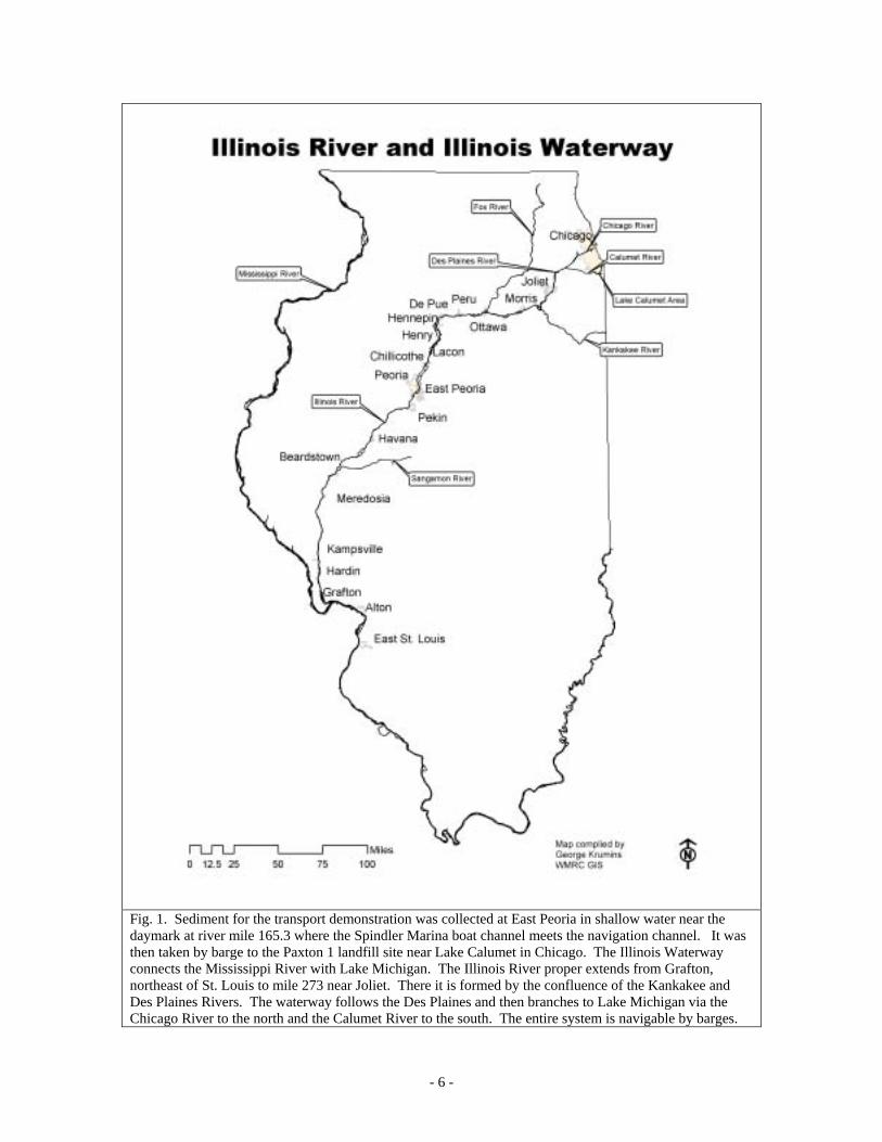
Fig. 1. Sediment for the transport demonstration was collected at East Peoria in shallow water near the daymark at river mile 165.3 where the Spindler Marina boat channel meets the navigation channel. It was then taken by barge to the Paxton 1 landfill site near Lake Calumet in Chicago. The Illinois Waterway connects the Mississippi River with Lake Michigan. The Illinois River proper extends from Grafton, northeast of St. Louis to mile 273 near Joliet. There it is formed by the confluence of the Kankakee and Des Plaines Rivers. The waterway follows the Des Plaines and then branches to Lake Michigan via the Chicago River to the north and the Calumet River to the south. The entire system is navigable by barges.
- 6 -
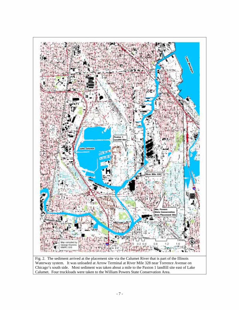
Fig. 2. The sediment arrived at the placement site via the Calumet River that is part of the Illinois Waterway system. It was unloaded at Arrow Terminal at River Mile 328 near Torrence Avenue on Chicago’s south side. Most sediment was taken about a mile to the Paxton 1 landfill site east of Lake Calumet. Four truckloads were taken to the William Powers State Conservation Area.
- 7 -

Fig. 3. Sediment is placed in a barge on Lower Peoria Lake on September 27, 2002. A clam shell bucket is used to minimize free water.
Fig. 4. In Chicago on October 2 the barge contains little free water. Four truckloads were removed that day.
Fig. 5. On October 7, after receiving 1.5 inches of rain during the week.
Fig. 6. A three cubic yard excavator removing sediment from the barge. The top layer has begun to dry and form a thin crust.
Fig. 7. The dredged material handled well in the bucket and maintained its consistency.
Fig. 8. Later in the day an endloader inside the barge pushed material into a pile to assist the excavator.
- 8 -

Fig. 9. The material readily flowed from the bucket into trucks.
Fig. 10. The sediment maintained its consistency and piled inside the trucks.
Fig. 11. Material placed at the William Powers Conservation Area made distinct piles about 30 inches high when dumped in one spot.
Fig. 12. A moving truck left a long pile with a height dependent upon the speed of the truck.
Fig. 13. The material was stiff enough to allow an endloader to spread it without using a form.
Fig. 14. Sediment spread to a depth of about six inches on the day it was deposited at the Powers site.
- 9 -
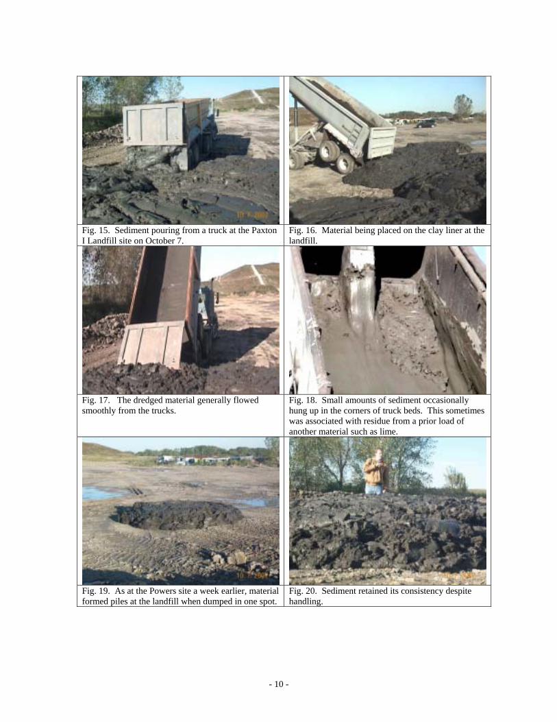
Fig. 15. Sediment pouring from a truck at the Paxton I Landfill site on October 7.
Fig. 16. Material being placed on the clay liner at the landfill.
Fig. 17. The dredged material generally flowed smoothly from the trucks.
Fig. 18. Small amounts of sediment occasionally hung up in the corners of truck beds. This sometimes was associated with residue from a prior load of another material such as lime.
Fig. 19. As at the Powers site a week earlier, material formed piles at the landfill when dumped in one spot.
Fig. 20. Sediment retained its consistency despite handling.
- 10 -

Fig. 21. Trucks were able unload sediment in contiguous piles demonstrating the ability to form a continuous layer about two feet thick.
Fig. 22. Sediment several hours after placement at the Paxton I site.
Fig. 23. Sediment stayed in place along the side of the roadway leading up the landfill flowed only a few inches downhill. The slope is 8%.
Fig. 24. Material placed at the Powers site maintained its shape, but could not support a person’s weight on October 7.
Fig. 25. Sediment at the Powers site showed evidence of soil formation on January 13. The top layer was granular and easily broken apart by hand.
Fig. 26. Ice crystals laced the sediment for about three inches below the granular material. Below that the sediment was moist and plastic.
- 11 -

APPENDIX
Sample Test Results
Documentation to Accompany Whitney & Associates Report of 11-5-02. Prepared by John C. Marlin
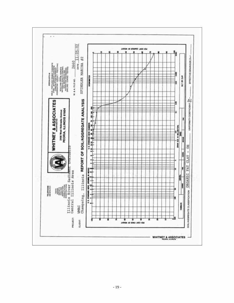
Whitney & Associates of Peoria, Illinois, when analyzing sediment samples from the Illinois River backwaters, used the following standards: Grain Size Analysis Test ASTM D-422 Atterberg Limits Test ASTM D-4318 Moisture Content Test ASTM D-2216 Specific Gravity Test ASTM D-854 Information on samples referred to in this report: Samples were placed in sealed plastic bags. SPIN-1 and 2. Samples were taken of sediment being loaded on a barge from shallow water on Sept. 27, 2002 near the main channel in Lower Peoria Lake near River Mile (RM) 165.5. The sediment was sent to the Paxton I landfill and William Powers sites. TS-1A, TS-2A. TS-3 and TS-4A. Representative samples taken October 2 of sediment placed by each of four trucks at the William powers Site. TS-2B and TS 4-B. These samples taken October 2 at the William Powers site were selected because they appeared to be firmer than the representative sediment. They may have been at the top of the barge and subject to more drying than the representative samples. PXTR-1--8. Samples with this designation are representative of material placed by eight different trucks at the Paxton I landfill site on October 7. PXT-9--11. These samples taken October 7 at the Paxton I landfill site were selected because they appeared to be firmer than the representative sediment. They may have been at the top of the barge and subject to more drying than the representative samples.
- 12 -
The following samples used for another project at Lacon, Illinois are in the same Whitney and Associates report: WTM- 8--11. Samples of sediment taken within an hour of being removed from shallow water in Wightman Lake near the main channel at RM 187.5 south of Lacon, Ill., on Sept. 25, 2002. Samples were from several areas on the deck; no two samples were from the same bucket. WTM-12, 13, and 14. Samples were taken from one spot in the sediment stockpile for the handling demonstration. Sample 12 was taken 0.1 to 0.4 inches below the top of the pile, sample 13 was taken 1.0 to 1.3 feet below the top, and sample 14 was taken 2.0 to 2.3 feet below the top of the pile near the original soil surface. They were taken to provide insight as to whether or not the sediment lost moisture to the dry ground or air while stockpiled overnight. WTM-15 and 16. Samples were taken a few inches below the surface of two sediment piles consisting of material that had been pumped and conveyed. The samples were taken at about 3 PM on Sept. 26, 2002.
- 13 -

- 14 -

- 15 -

- 16 -

- 17 -

- 18 -
- 19 -

- 20 -

- 21 -
