patterns, determinants, impacts and policy implications of
TRANSCRIPT
International Journal of Sustainable Built Environment (2013) 2, 193–208
Gulf Organisation for Research and Development
International Journal of Sustainable Built Environment
ScienceDirectwww.sciencedirect.com
Original Article/Research
Patterns, determinants, impacts and policy implications ofthe spatial expansion of an African capital city: The Greater
Gaborone example
Reuben J. Sebego ⇑, Thando D. Gwebu
Department of Environmental Science, University of Botswana, Gaborone, Botswana
Received 16 August 2013; accepted 17 December 2013
Abstract
Africa has experienced unprecedented rates of urban growth, at above 3% annually. This growth was accompanied not only byagglomeration economies and spread effects but negative externalities that impinge on the inhabitants and the natural resource basein the rural–urban transition zone. Already, cities occupy large geographical areas that are continually expanding. Botswana’s popula-tion is small with a recent urbanization history. However, it has recorded one of the highest urbanization levels (61%) and annual urbangrowth rates (2.5%). Unlike in most developed countries, the dynamics of peri-urbanization in Gaborone reflect a strong interplay ofmarket and institutional factors. Actual population growth and demand for space has always defied projected forecasts. The countrypresents unique prospects for investigating patterns and processes that characterize urban growth and their intersecting environmentaland policy implications for sustainable urbanization.
The study utilizes a developmental approach based on spatial data to describe, interpret and analyse patterns and processes that deter-mined the growth of Gaborone. It is evident that certain developments within the urban shadow of the city have been unregulated. Inspite of the apparent ecological footprints resultant from the geographical manifestation of urban growth, legislative mitigation measureshave rarely been implemented to promote sustainable urbanization.� 2014 The Gulf Organisation for Research and Development. Production and hosting by Elsevier B.V.
Keywords: Urbanization; Peri-urban; Ecological footprintOpen access under CC BY-NC-ND license.
1. Introduction
Demographic and spatial aspects of urbanization havealways held academic fascination among social scientists
2212-6090 � 2014 The Gulf Organisation for Research and Development. Prod
http://dx.doi.org/10.1016/j.ijsbe.2013.12.002
⇑ Corresponding author. Tel.: +267 3552518.E-mail address: [email protected] (R.J. Sebego).
Peer-review under responsibility of The Gulf Organisation for Researchand Development.
Production and hosting by Elsevier
and planners in Africa. The first facet relates mainly to therapid increase of the sheer numbers of urban residents. Thesecond concerns both the organization of urban space,necessitated by the demographic growth of towns and cities,and the dynamics of settlements as a hierarchical system(Geyer, 2003; Gwebu, 2006; Gwebu, 2012). Concomitantwith the above dimensions have been the sociological andeconomic processes that accompany urbanization. The firstdynamic perceives urbanization as a way of life that perme-ates and transforms the behavioural patterns of theurbanized sub-populations, for example, in terms of theirconsumption, production, reproduction and secular
uction and hosting by Elsevier B.V. Open access under CC BY-NC-ND license.
194 R.J. Sebego, T.D. Gwebu / International Journal of Sustainable Built Environment 2 (2013) 193–208
outlook. The second component views urbanization as apowerful engine for national economic growth.
The impact of the dynamic urbanization synergy of theabove dimensions can be observed both in situ, withintowns and cities and throughout the entire space economiesof the African continent, as impulses of urbanization dif-fuse from cores to the national geographical peripheries.Of practical significance is the fact that these processes gen-erate stresses and conflicts among the various stakeholders.This creates the need for coherent, systematic and equitableregulatory instruments to be put in place to manage urban-ization sustainably.
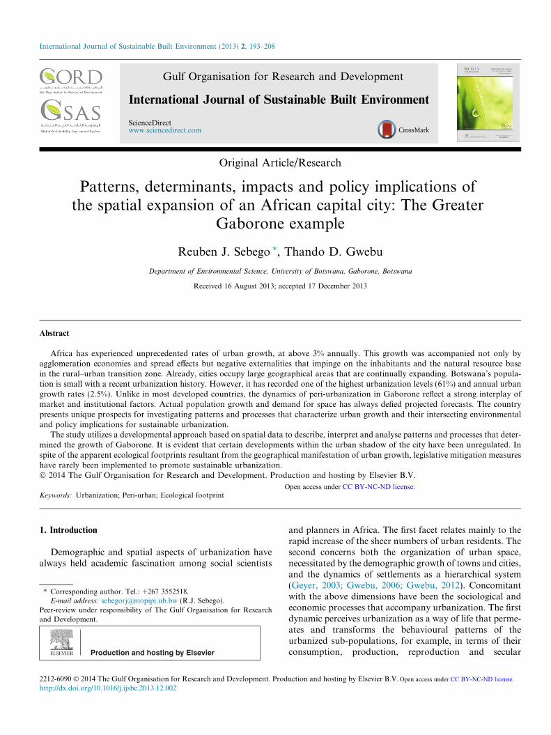
Rapid urbanization has not only brought about regionaldevelopment inequalities and over-urbanization butagglomeration economies, to the advantage of nationaleconomic development. It is in an attempt to regularizeand streamline its urbanization process that Botswanahas adopted and adapted the concept of sustainable urban-ization (ROB, 2004; Drakakis-Smith, 1996, 2000; UN,2004).Previous studies on the geographic growth of majorurban centres in Africa have only made cursory referenceto the spatial manifestation of such expansion. This paperintends to both describe and analyse, in detail, the spatialexpansion of Botswana’s national capital. The focus is onthe built- up and fringe zone of transition in land-use,social and demographic characteristics lying between thecontinuously built-up area and the rural hinterland, shownin Fig. 1.
The aim of the study is to therefore generate knowledgeon the: spatial patterns of urban growth; stresses and con-flicts that have arisen among competing resource claims;the role of public planning in resolving such conflicts;and presenting possible future scenarios on how the urban-ization process could be rationally and sustainably man-aged. The paper is organized into subsections. After thisIntroduction, the conceptual base of urban structure and
Dispersed subsystem, urban field or
City’s
Maximum commuting zone
Weekend and Seasonal lifespace
Urbannode
Concencity or
Core bup are
Fig. 1. The structural elements of the city
growth are discussed. Next, the features of the study areaare summarized. The methodology for conducting theresearch is then outlined. Fourthly, the findings from thestudy are reported and analysed. Finally, conclusions andrecommendations are made.
1.1. Conceptual basis of urban spatial structure, expansion
and response
The study examines the relationship between the built-up city and the spaces of its shadow zone shown in Fig.1.What is interesting about this study is that both marketand institutional factors seem to play an active role indetermining patterns and processes of peri-urbanizationin the study area.
Bryant et al. (1982: 34) have pointed out that a cityspreads out into the countryside like an advancing waveon a beach and land in the fringe, be it farmland, grasslandor forest, and is converted to urban use. Bryant et al. (1982:34) best captures this scenario thus:
...there is more than just the advance of the built-upedge. Likea wave braking on a rocky shore, irregular patches ofurban andurban-associated land uses develop well beyond thebuilt-up edgewith ribbons of development, at least in the early stagesofdevelopment...It is this ribbon and scattered develop-ment that canbest be labelled ‘urban sprawl’ and which generates mostland-useconflicts.
Similarly, Greene and Pick (2006) have made reference tothe bow wave analogy in explaining the processes that
Isolate Residence
trated
uilta
Inner fringeOuter fringe
Rural –Urban fringeOr urban fringe Urban
ShadowRuralhinterland
region. Source: Bryant et al. (1982).
R.J. Sebego, T.D. Gwebu / International Journal of Sustainable Built Environment 2 (2013) 193–208 195
underlie land use changes at the urban fringe. According toHart (1991, 36),
the bow wave is a standing wave that always remainsimmediately in front of the bow of a ship movingthrough water. The urban–rural fringe then is the bowwave of the built-up area of the city, that remains imme-diately in front of the expanding edge.
This conceptualization assumes the existence of a contigu-ous zone of expansion at the urban fringe. However, in cer-tain circumstances nuclei may develop, throughleapfrogging, and serve as a basis for residential, industrialor institutional use. Eventually, such nuclei may mergewith the main built-up area. This, in essence, is the basisfor the multinuclear morphogenesis of urbanization.
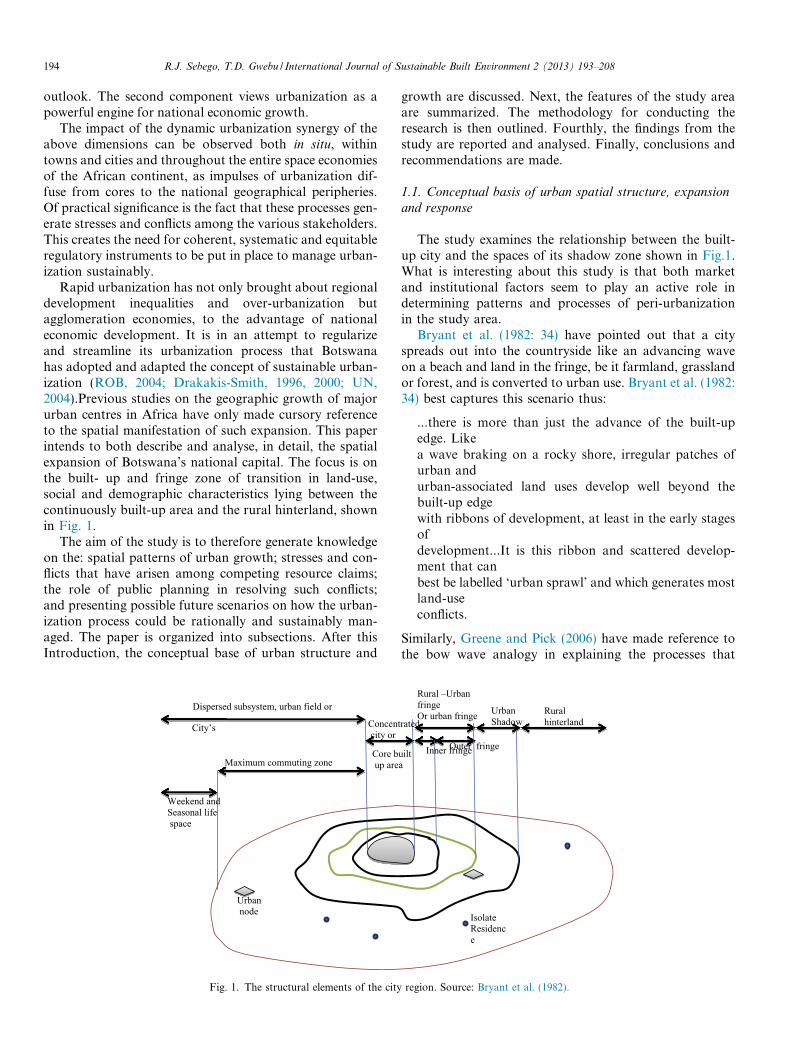
Concentrated urban markets generate demands for cer-tain resources such as food, construction materials, energyresources, land and labour from the periphery sub-region,shown in Fig. 2. The depicted Stimulus–Response compo-nents of the research problem and how they interact areillustrated. The stimulus in this case is provided by theurban core with its various types of demands shown. Thestimuli take the form of demand for agricultural products,labour and land. Various responses emanate from the peri-urban areas in the form of diverse primary and serviceactivities. The responses take the form of satisfying thedemands from the core in various ways from the periphery.
As the urbanization process unfolds, adjacent peripheralspaces become progressively integrated into the city region.Some of the earliest concepts on urban spatial structureand growth have been articulated in terms of urban ecolog-ical processes that derive from the biological analogies ofinvasion, competition, dominance and succession of natu-ral areas occupied by various land-uses (Alonso, 1964; Bur-gess, 1925). From those perspectives, there is invasion ofnatural areas by competing groups, competition betweenthe invaders and the invaded, and eventual dominance ofthe fringe areas by invaders, thus facilitating their succes-sion to and dominance of the area.
Fig. 2. Forces of urbanizat
The dynamics of the urban ecological processes havebeen rationalized in economic terms, based on basic netreturn or locational rent (Bissett, 2004; Speigel, 1971;Lipsey, 1975).
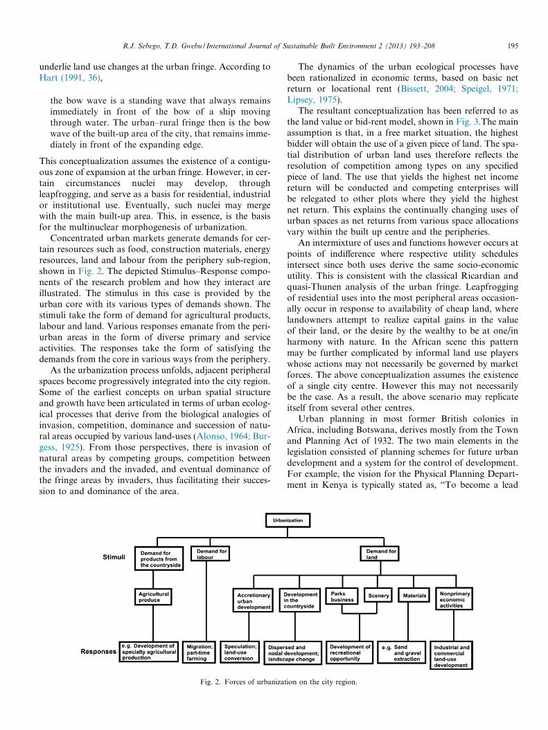
The resultant conceptualization has been referred to asthe land value or bid-rent model, shown in Fig. 3.The mainassumption is that, in a free market situation, the highestbidder will obtain the use of a given piece of land. The spa-tial distribution of urban land uses therefore reflects theresolution of competition among types on any specifiedpiece of land. The use that yields the highest net incomereturn will be conducted and competing enterprises willbe relegated to other plots where they yield the highestnet return. This explains the continually changing uses ofurban spaces as net returns from various space allocationsvary within the built up centre and the peripheries.
An intermixture of uses and functions however occurs atpoints of indifference where respective utility schedulesintersect since both uses derive the same socio-economicutility. This is consistent with the classical Ricardian andquasi-Thunen analysis of the urban fringe. Leapfroggingof residential uses into the most peripheral areas occasion-ally occur in response to availability of cheap land, wherelandowners attempt to realize capital gains in the valueof their land, or the desire by the wealthy to be at one/inharmony with nature. In the African scene this patternmay be further complicated by informal land use playerswhose actions may not necessarily be governed by marketforces. The above conceptualization assumes the existenceof a single city centre. However this may not necessarilybe the case. As a result, the above scenario may replicateitself from several other centres.
Urban planning in most former British colonies inAfrica, including Botswana, derives mostly from the Townand Planning Act of 1932. The two main elements in thelegislation consisted of planning schemes for future urbandevelopment and a system for the control of development.For example, the vision for the Physical Planning Depart-ment in Kenya is typically stated as, “To become a lead
ion on the city region.
Fig. 3. Locational rent among competing urban and peri-urban landuses.
196 R.J. Sebego, T.D. Gwebu / International Journal of Sustainable Built Environment 2 (2013) 193–208
agency in the promotion of well-planned and sustainablehuman settlements” (http://www.ardhi.go.ke/plan-ning.html). Since the mid-1990s Local Agenda 21 hasinspired the incorporation of sustainability into the plan-ning of human settlement.
The problems associated with the physical growth oftowns and cities are however worsening in spite of the factthat nearly every African country has Physical Planningand Development Control legislation in its human settle-ments planning statute books (Silitshena, 1996; Clancy,2008; Lovett, 2008). In spite of the enormous social andeconomic challenges of rapid urbanization; physical plan-ning in African countries often remains a peripheral ifnot an uncoordinated activity (Killick, 2008; Toteng,2001; Wekwete, 1995).
From a purely technical point of view, three main fac-tors could be responsible for the failure of planning anddevelopment control (Silitshena, 1996:114–115) in the con-tinent’s main cities. First is the failure to regard physicalplanning as an integral part of economic and social plan-ning. Currently it is viewed as a sectoral activity concernedwith works, housing, communications and local govern-ment. Secondly, there is a failure to retain technical andprofessional staff who are the key implementers of develop-ment control, because of low salaries and poor workingconditions. Finally, there is an absence of political willdue to lack of real power or from corruption on the partof enforcing officials. Other factors include: the failure toperceive the settlement components as functional systemselements rather than addressing systems’ elements in isola-tion; lack of meaningful communication among stakehold-ers due to centralization and lack of participatory planningand absence of coordination among the various planning
units e.g., Physical Planning, District Development Com-mittees and Land Boards.
More fundamentally, reference has been made to legalpluralism, a situation in which two or more legal land ten-ure systems co-exist at the urban fringe, each with its ownbasis of legitimacy and validity (Von Benda-Beckmann,2002). When studying peri-urban land problems from alegal pluralistic perspective, it must be appreciated thatthere is not just one legal system that applies to peri-urbanland claims nor a simple division between customary andstatutory rules, but rather overlapping legal and normativeframeworks at work. The (mis-) appropriation of commu-nal or Tribal Land and disenfranchisement of communalcitizens including those surrounding the expanding urbanareas, in East and Southern Africa (Gwebu, 2002:148–149) can be explained from this conceptualization. Thedriving factors include unreflective public policies, preda-tory governments, kleptocratic bureaucracies and, growingand shifting populations.
Wily (1999) has identified three main influences thatcould help to explain the changes that are threatening com-mon property rights within the city regions of sub-SaharanAfrica. First are social transformation factors that haveemanated from the penetration of capital and the modern-ization of previously pre-capitalist and traditional Africansocieties. Central to this dynamic has been the commodifi-cation of land as a core means of production, the provi-sions for which have been central to the essence ofmodern national land legislation (Wily, 1999:78).
Next, the thrust of colonial and present tenure ideologytowards the privatization of land-ownership through Wes-tern modes of entitlement has been coupled with a failureto institute statutory provisions for the non-European
R.J. Sebego, T.D. Gwebu / International Journal of Sustainable Built Environment 2 (2013) 193–208 197
regimes of landholding (Wily, 1999:78–79). According toWily, customary African tenure has been regarded as a par-adigm from which modern society should depart. The gen-eral expectation has therefore been that over time, throughmarket forces, and with the assistance of programmes oftenure conversion, common rights and regimes which sus-tain them would eventually disappear. They would thenbe absorbed into modern statutory forms, particularlythose providing absolute and individual rights (Wily,1999:78–79).
Thirdly, there has been a steady appropriation of muchof the most valuable local common property by colonialand post-colonial governments, based on the assumptionthat the state is the only and proper guardian of such prop-erties, and the rightful primary beneficiary of their worth.Governments have accordingly vested the ownership ofthe communally-held lands, not on their rightful inhabit-ants, but variously on the state and local authorities (Wily,1999:80). Nowadays, Councils may unilaterally allocatecustomarily occupied land for purposes which they them-selves consider beneficial to the residents. Essentially,therefore customary owners occupy and use their lands asbut tenants of state and state agencies, with their landbeing directly vulnerable to arbitrary reallocation (Wily,1999:80). Their local land rights have thus, to all intentsand purposes evaporated to that of permissive occupancy.
Unlike previous studies that have focused purely on thepolitical, legal, institutional and historical factors thatcharacterize peri-urbanization (Nkambwe , 2003; Kalab-amu and Morolong, 2004; Nkambwe and Totolo, 2005;Ikgopoleng et al., 2011) in Botswana, this systematic studywill attempt to map and explain urban fringe changes withreference to the above conceptual frameworks and the useof relevant spatial and statistical tools.
2. Description of the study area
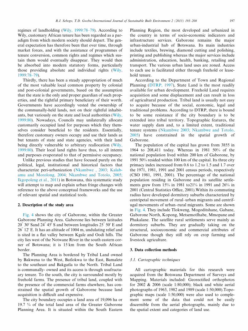
Fig. 4 shows the city of Gaborone, within the GreaterGaborone Planning Area. Gaborone lies between latitudes20� 300 Sand 24� 450 S and between longitudes 25� 500 E and26� 120 E. It has an altitude of 1004 m, undulating relief andis sited in a flat valley between Kgale and Oodi hills. Thecity lies west of the Notwane River in the south eastern cor-ner of Botswana; it is 15 km from the South Africanborder.
The Planning Area is bordered by Tribal Land ownedby Bakwena to the West, Batlokwa to the East, Bamaleteto the southeast and Bakgatla to the North. Tribal Landis communally- owned and its access is through usufructu-ary tenure. To the south, the city is surrounded mostly byfreehold farms. The presence of tribal land, coupled withthe presence of the commercial farms elsewhere, has con-strained the spatial growth of Gabororne because landacquisition is difficult and expensive.
The city boundary occupies a land area of 19,096 ha or19.7 % of the total land area of the Greater GaboronePlanning Area. It is situated within the South Eastern
Planning Region, the most developed and urbanized inthe country in terms of socio-economic indicators andinfrastructure services. Gaborone remains the majorurban-industrial hub of Botswana. Its main industriesinclude textiles, brewing, diamond cutting and polishing,printing and publishing whereas the major services includeadministration, education, health, banking, retailing andtransport. The various urban land uses are zoned. Accessto each use is facilitated either through freehold or lease-hold tenure.
According to the Department of Town and RegionalPlanning (DTRP, 1997), State Land is the most readilyavailable for urban development. Freehold Land requiresacquisition and some displacement and can result in lossof agricultural production. Tribal land is usually not easyto acquire because of the social, economic, legal andtraditional problems. According to DTRP, there is boundto be some resistance if the city boundary is to beextended into tribal territory. Topographic features, thewater supply dam and, to a limited extent, traditionaltenure systems (Nkambwe 2003; Nkambwe and Totolo,2005) have constrained in the spatial growth ofGaborone.
The population of the capital has grown from 3855 in1964 to 208,411 today. Whereas in 1981 50% of thenational population lived within 200 km of Gaborone, by1991 50% resided within 100 km of the capital. Its three cityprimacy index increased from 0.6 to 1.2 to 1.5 and 1.7 overthe 1971, 1981, 1991 and 2001 census periods, respectively(CSO 1981, 1991, 2001). The percentage of the nationalpopulation residing in Gaborone and its satellite settle-ments grew from 15% in 1981 to21% in 1991 and 26% in2001 (Central Statistics Office, 2001).Within its commutingradius have developed dormitory suburbs characterized bycentripetal movement of rural–urban migrants and centrif-ugal movements of urban–rural migrants. Some are shownin Fig. 4. They include Tlokweng, Mogoditshane, Gabane,Gaborone North, Kopong, Metsemotlhabe, Mmopane andPhakalane. The satellite rural settlements serve mainly asdormitory suburbs. They are gradually taking on thestructural, socioeconomic and commercial attributes ofGaborone though they still rely on crop farming andlivestock agriculture.
3. Data collection methods
3.1. Cartographic techniques
All cartographic materials for this research wereacquired from the Botswana Department of Surveys andMapping. Materials included: Georectified orthophotosfor 2002 & 2006 (scale 1:80,000); black and white aerialphotographs of 1963, 1982 and 1989 (scale 1:50,000).Topo-graphic maps (scale 1:50,000) were also used to comple-ment some of the data that could not be easilydiscernible from the aerial photographs, mainly due tothe spatial extent and categories of land use.
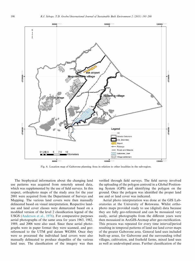
Fig. 4. Location map of Gaborone planning Area in relation to other localities in the sub-region.
198 R.J. Sebego, T.D. Gwebu / International Journal of Sustainable Built Environment 2 (2013) 193–208
The biophysical information about the changing landuse patterns was acquired from remotely sensed data,which was supplemented by the use of field surveys. In thisrespect, orthophoto maps of the study area for the year2001 were acquired from the Department of Surveys andMapping. The various land covers were then manuallydelineated based on visual interpretation. Respective land-use and land cover classes were demarcated based on amodified version of the level 2 classification legend of theUSGS (Anderson et al., 1976). For comparative purposesaerial photographs of the same area for years 1963, 1982,1989, and 2006 were also used. Since these aerial photo-graphs were in paper format they were scanned, and geo-referenced to the UTM grid datum WGS84. Once theywere so processed the individual land covers were alsomanually delineated to produce shapefiles of the variousland uses. The classification of the imagery was then
verified through field surveys. The field survey involvedthe uploading of the polygon centroid in a Global Position-ing System (GPS) and identifying the polygon on theground. Once the polygon was identified the proper landuse and or land cover was indicated.
Aerial photo interpretation was done at the GIS Lab-oratories at the University of Botswana. Whilst ortho-photo maps provided ready to use (digital) data becausethey are fully geo-referenced and can be mossaiced veryeasily, aerial photographs from the different years werethen mossaiced in ArcGIS-Arcmap after geo-rectification.This process was repeated for every time interval/periodresulting in temporal patterns of land use land cover mapsof the greater Gaborone area. General land uses includedbuilt-up areas, for Gaborone and the surrounding tribalvillages, cultivation, and freehold farms, mixed land usesas well as undeveloped areas. Further classification of the
0
5000
10000
15000
20000
25000
30000
35000
1963 1982 1989 2002 2006
Agriculture
Total
Fig. 5. Extent of agricultural and total built-up area in hectares 1963–2006.
R.J. Sebego, T.D. Gwebu / International Journal of Sustainable Built Environment 2 (2013) 193–208 199
city expanse was done on the basis of specific land usessuch as residential, commercial, industrial, etc. Thespatio-temporal variations between the time intervalswere also translated into area extent for a quantifiedcomparison.
The initial developments captured here were largely onState Land for the town of Gaborone, private lands, andmostly the titled farms and Tribal Land where the villagesof Mogoditshane and Tlokweng are located. These catego-ries were captured into individual shapefiles producing atemporal development of what is now referred to as theGreater Gaborone Planning Area. Spatial areas for tempo-ral developments were derived from the shapefiles using the‘Calculate areas’ utility in Arcmap.
Mapping change makes it possible for researchers tofirstly, show trends in city growth, secondly, indicate ormodel possibilities for outward growth and thirdly toprovide indicators for known conceptual models for citygrowth and development. With change mapping, anyproblems/challenges associated with urban sprawl anddisplacement of rural based agricultural activities canbe evaluated. Development change was made possiblemainly by the availability of air photographs of the citycovering the periods from the 1960s when there wasvirtually nothing in terms of modern developments.Change mapping was done by combining the time seriesspatial data in a GIS and subjecting them to overlayanalysis.
The landscape of Gaborone is ever changing; certainareas in the city have just been subjected to developmenthence they are not shown or reflected even on the mostrecent (2006) aerial photographs. Field observations andlocal knowledge of the city bounds and development planshave helped in this regard.
3.2. Documentary sources
Secondary data and information from the Universitylibrary, National Archives and Records, National Museumand Records, Department of Town and Regional Planning,Gaborone City Council-Department of Physical Planning,Central Statistics Office were used to assist the interpreta-tion of the spatial patterns.
The University library provided the information oncomparative studies that have been conducted on urbaniza-tion and peri-urbanization. This furnished the study with avital background on the demographic, economic and policydrivers of urbanization and peri-urbanization. The under-pinning conceptual and theoretical frameworks were alsoobtained from the library sources. Data and informationfrom the National Archives and Museum records were use-ful for reconstructing the evolutionary spatial processes ofthe study area. The Department of Town and RegionalPlanning and Gaborone City Council Physical PlanningDivision provided the maps of the study area. The CentralStatistics Office supplied the necessary socio-demographicand socio-economic data for the study.
4. Results
The following section discusses the growth of Gaboroneover time and its growth patterns over space over time,from 1963 to 2006.
4.1. The Growth of Gaborone over time
Fig. 5 presents a comparison of the areal extent of agri-cultural land to the total built-up area from 1963 to 2006.The farming area declined by 42%, from about 31,000 ha in1963 to approximately 18,000 ha, over the study period.There was a 4% increase between 1982 and 1989, attribut-able most likely to state support for the Accelerated Rain-fed Agriculture Programme. Thereafter, farming hectaragedeclined by 30% between 1989 and 2002 and by 2%between 2002 and 2006. In contrast, the total built-up areahas been on the increase recording its highest percentagechange of about 117% between 1989 and 2002. This is areflection of the economic boom that was accompaniedby the vibrancy of the construction sector that began inthe late 80s and early 90s. The relationship between thedecline of the agricultural area and the total built-up areais reflected by a strong negative rank order correlation rs
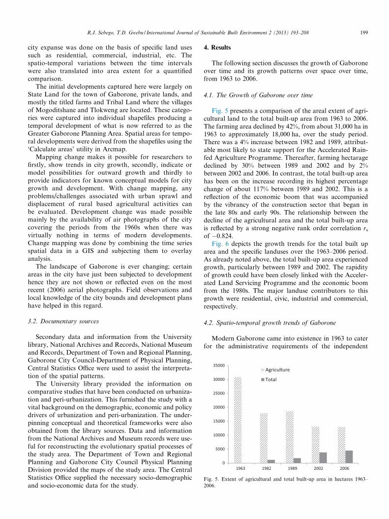
of �0.824.Fig. 6 depicts the growth trends for the total built up
area and the specific landuses over the 1963–2006 period.As already noted above, the total built-up area experiencedgrowth, particularly between 1989 and 2002. The rapidityof growth could have been closely linked with the Acceler-ated Land Servicing Programme and the economic boomfrom the 1980s. The major landuse contributors to thisgrowth were residential, civic, industrial and commercial,respectively.
4.2. Spatio-temporal growth trends of Gaborone
Modern Gaborone came into existence in 1963 to caterfor the administrative requirements of the independent
0
500
1000
1500
2000
2500
3000
3500
4000
4500
5000
Total Residen�al Civic Commercial Industrial
1963
1982
1989
2002
2006
Fig. 6. Extent of total built-up area and specific landuses in hectares1963–2006.
200 R.J. Sebego, T.D. Gwebu / International Journal of Sustainable Built Environment 2 (2013) 193–208
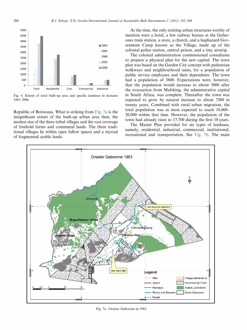
Republic of Botswana. What is striking from Fig. 7a is theinsignificant extent of the built-up urban area then, themodest size of the three tribal villages and the vast coverageof freehold farms and communal lands. The three tradi-tional villages lie within open fallow spaces and a myriadof fragmented arable lands.
Fig. 7a. Greater Ga
At the time, the only existing urban structures worthy ofmention were a hotel, a few railway houses at the Gaber-ones train station, a store, a church, and a haphazard Gov-ernment Camp known as the Village, made up of thecolonial police station, central prison, and a tiny airstrip.
The colonial administration commissioned consultantsto prepare a physical plan for the new capital. The townplan was based on the Garden City concept with pedestrianwalkways and neighbourhood units, for a population ofpublic service employees and their dependents. The townhad a population of 3800. Expectations were, however,that the population would increase to about 5000 afterthe evacuation from Mafeking, the administrative capitalin South Africa, was complete. Thereafter the town wasexpected to grow by natural increase to about 7500 intwenty years. Combined with rural urban migration, thetotal population was at most expected to reach 18,000–20,000 within that time. However, the population of thetown had already risen to 17,700 during the first 10 years.
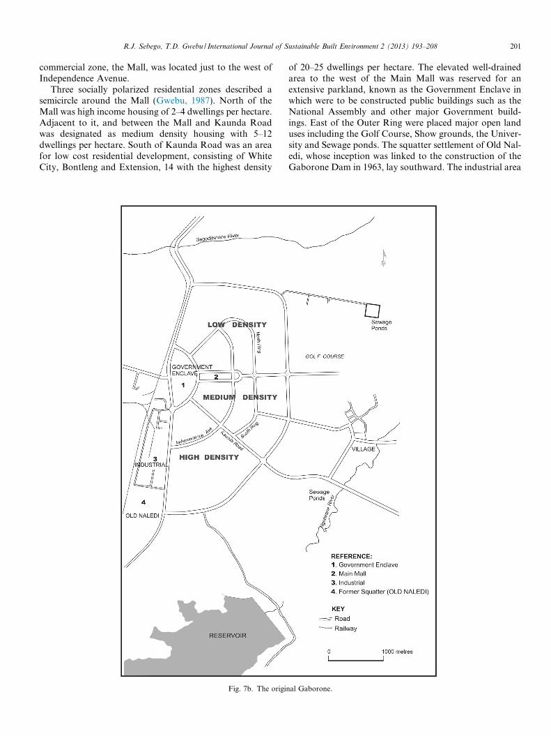
The Master Plan provided for six types of landuses,namely; residential, industrial, commercial, institutional,recreational and transportation. See Fig. 7b. The main
borone in 1963.
R.J. Sebego, T.D. Gwebu / International Journal of Sustainable Built Environment 2 (2013) 193–208 201
commercial zone, the Mall, was located just to the west ofIndependence Avenue.
Three socially polarized residential zones described asemicircle around the Mall (Gwebu, 1987). North of theMall was high income housing of 2–4 dwellings per hectare.Adjacent to it, and between the Mall and Kaunda Roadwas designated as medium density housing with 5–12dwellings per hectare. South of Kaunda Road was an areafor low cost residential development, consisting of WhiteCity, Bontleng and Extension, 14 with the highest density
Fig. 7b. The origin
of 20–25 dwellings per hectare. The elevated well-drainedarea to the west of the Main Mall was reserved for anextensive parkland, known as the Government Enclave inwhich were to be constructed public buildings such as theNational Assembly and other major Government build-ings. East of the Outer Ring were placed major open landuses including the Golf Course, Show grounds, the Univer-sity and Sewage ponds. The squatter settlement of Old Nal-edi, whose inception was linked to the construction of theGaborone Dam in 1963, lay southward. The industrial area
al Gaborone.
202 R.J. Sebego, T.D. Gwebu / International Journal of Sustainable Built Environment 2 (2013) 193–208
was to be adjacent to the railway, southwest of the publicand commercial areas closest to the lowest income highdensity area of Old Naledi.
The spatial expansion of the incipient urban area washowever constrained to the east by the airstrip, the Notw-ane river and the tribal boundary of the Batlokwa. Therailway and the tribal boundary of the Bakwena presentedbarriers to the westerly expansion of the built up area.
Gaborone was expected to grow at an annual rate of10.3% between 1975 and 1980; 8.4% between 1980 and1985 and to then stabilize around 7% in the late 1980s.Rural–urban migration was estimated at about 2500individuals per year and the need to provide housing ona sustained and substantial scale was acknowledged, inorder to forestall the re-emergence of squatting as hadoccurred in Old Naledi. The projected population was40,000 by 1980 and 72,000 by 1990. It was however soonrealized that the earlier estimates of the population werelower and that in 1980 the town population would bebetween 128 000 and 148 000.
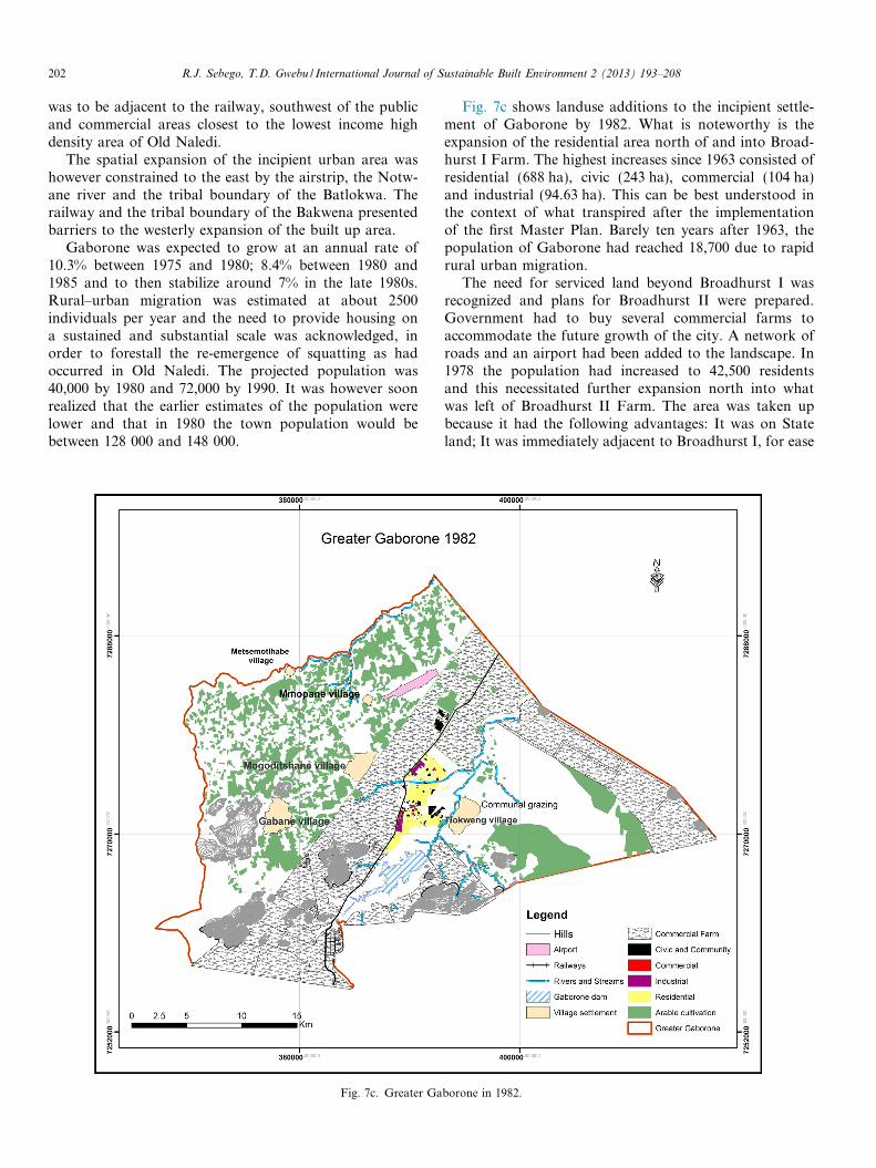
Fig. 7c. Greater Ga
Fig. 7c shows landuse additions to the incipient settle-ment of Gaborone by 1982. What is noteworthy is theexpansion of the residential area north of and into Broad-hurst I Farm. The highest increases since 1963 consisted ofresidential (688 ha), civic (243 ha), commercial (104 ha)and industrial (94.63 ha). This can be best understood inthe context of what transpired after the implementationof the first Master Plan. Barely ten years after 1963, thepopulation of Gaborone had reached 18,700 due to rapidrural urban migration.
The need for serviced land beyond Broadhurst I wasrecognized and plans for Broadhurst II were prepared.Government had to buy several commercial farms toaccommodate the future growth of the city. A network ofroads and an airport had been added to the landscape. In1978 the population had increased to 42,500 residentsand this necessitated further expansion north into whatwas left of Broadhurst II Farm. The area was taken upbecause it had the following advantages: It was on Stateland; It was immediately adjacent to Broadhurst I, for ease
borone in 1982.
R.J. Sebego, T.D. Gwebu / International Journal of Sustainable Built Environment 2 (2013) 193–208 203
of access, sharing of services and facilities. A major com-mercial centre was planned there; and, Indications werethat the area could accommodate Gaborone’s estimatedhousing needs for the next 4–5 years (DTRP, 1978:16).
Unlike the socially polarized Garden City of Gaborone,Broadhurst I and II had six socially integrated neighbour-hoods with 4200 residential of high, middle and site andservice plots, an industrial area, a central shopping areaand community facilities. Additional housing needs wereto be met by the development of State land at BroadhurstIII/Tsholofelo.
The layout made provision for 1300 integrated plotsneighbourhoods. A shortage of site and service plots in1981 further prompted the Government to approve 500plots in the Tsholofelo Extension, north of Tsholofelo.There was also the sale of unserviced residential blocks toprivate developers as well as to the Botswana Housing Cor-poration for the construction of medium and high incomehousing.
By 1982, the Village residential area had expanded fur-ther. To the south, government’s formal recognition of aformer squatter settlement of Old Naledi in 1978 wasaccompanied by upgrading in the form of providing phys-ical infrastructure and some 1600 low income site and ser-vice plots.
The traditional villages of Tlokweng, Mogoditshane andGabane had expanded in response to the peri-urban influ-ence of Gaborone.
After 1981, development of the area west of the railwayline, consisting of the freehold farm, Bonnington Farm,State Land and Broadhurst B, had been undertaken. By1989 the growth of Gaborone westwards had spilled overthe railway into Bonnington Farm, a purchased freeholdarea. See Fig. 7d.
Up to the late 1980s, urban development had beenoccurring rapidly although this growth was constrainedby shortage of serviced land. This implied constraints inthe provision of accommodation, services andinfrastructure.
In order to overcome this bottleneck, governmentlaunched the Accelerated Land Servicing Programme tospeed up the provision of serviced land for residential,commercial and industrial development. The New Policyof Allocation of State Land (1990) was directed at servicingGaborone West. The area, covering about 3000 ha, isbounded in the east by the railway line, on the west bythe boundary with Mogoditshane, on the north by Sebeleand south by Forest Hill 9-KO. See Fig. 7e. Ten superneighbourhood blocks/environmental areas accommodat-ing about 12,000 people each were earmarked. Each superBlock is a residential plot mix of all income categories witha great deal of emphasis on the provision of low incomehousing. Mixed income residential plots, local shoppingcentres, primary and secondary schools, parks and commu-nity facilities and three industrial areas were established.The latter comprise both rail and non-rail plots west ofthe railway station. Phakalane, a privately owned estate
located on the northern outskirts of Gaborone on theFrancistown–Gaborone road was developed.
There has been the development of a CBD which willconstitute the commercial heart of Gaborone, the centreof communication and the focus of business, offices, shop-ping and entertainment for the Greater Gaborone Area.Specifically, the planning concepts of the new CBD werethat it must: be compact and accessible; meet the require-ments of large and small investors, providing the state-of -the art infrastructure and technologies that are easilyaccessible to both clients and workers; provide goodexposure to potential markets; offer flexible developmentopportunities in terms of parcel size and potential build-ing types; support growing tourism in Botswana and becapable of accommodating investors within a frameworkthat allows for a logical incremental pattern of phaseddevelopment.
The peri-urban villages of Tlokweng, Mogoditshane,Metsemotlhabe, Mopane and Gabane, even if they remaintribal, have grown with the city as dormitory suburbs.
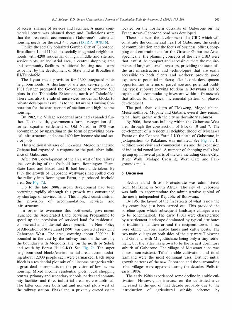
By 2006, there was infilling within the Gaborone Westarea through the construction of Blocks 10 and 7. Thedevelopment of a residential neighbourhood of MoshawaEstate on the Content Farm I-KO north of Gaborone, injuxtaposition to Pakalane, was initiated. See Fig. 7f. Inaddition were civic and commercial uses and the expansionof industrial zoned land. A number of shopping malls hadsprung up in several parts of the city including Game City,River Walk, Molapo Crossing, West Gate and Fair-grounds malls.
5. Discussion
Bechuanaland British Protectorate was administeredfrom Mafikeng in South Africa. The city of Gaboronewas built to accommodate the administrative capital ofthe newly independent Republic of Botswana.
By 1963 the layout of the first streets of what is now thecity centre had just been carried out. This provided thebaseline upon which subsequent landscape changes wereto be benchmarked. The early 1960s were characterizedby a settlement landscape dominated by typical attributesof traditional landuse around the incipient town. Thesewere ethnic villages, arable lands and cattle posts. Thetwo main villages on both sides of the city were Tlokwengand Gabane; with Mogoditshane being only a tiny settle-ment, but the latter has grown to be the largest dormitorysuburb of Gaborone. The village of Metsemotlhabe wasalmost non-existent. Tribal arable cultivation and titledfarmland were the most dominant uses. Distinct initialgrowth patterns of the new Gaborone and the surroundingtribal villages were apparent during the decades 1960s toearly 1980s.
The early 1980s experienced some decline in arable cul-tivation. However, an increase on the cultivated areaincreased at the end of that decade probably due to theintroduction of agricultural subsidy schemes by

Fig. 7d. Greater Gaborone in 1989.
204 R.J. Sebego, T.D. Gwebu / International Journal of Sustainable Built Environment 2 (2013) 193–208
government. The era of rapid residential and infrastructur-al development from the mid 1980s was accompanied byde-agrarianization around the fringes of Gaborone. The1997 Gaborone Development Plan envisaged that citygrowth would be accommodated in freehold land to thenorth and south of the city with a small proportion inthe Kweneng tribal area and small pockets within the city.
Patterns of land use change in the tribal areas havefollowed a distinct pattern as dictated by land pressure inthe inner city.
� A rapid conversion of agricultural land to built up arease.g., agricultural land between Mogoditshane andGabane and between Mogoditshane and Metsemotlha-be has all been displaced within two to three decades.This reflects total disregard for the city to be self-sus-taining in agricultural production.� Government has either purchased freehold land or
acquired tribal land and converted it to state landdestined for urban development.
� Residential land has been sold and converted to com-mercial and industrial use especially along the majorhighways passing through Mogoditshane andTlokweng.� Applications for residential land swelled on the tribal
lands forcing the Land Boards to accelerate land alloca-tion. This resulted in rapid increases in population inthese areas/villages.� The spontaneous settlement of Old Naledi has contin-
ued to grow rapidly as a receptacle for rural–urbanmigrants to Gaborone.� There has been a high rate of buying and selling of plots
in the tribal areas.� Up market residential structures characterize certain
areas of the villages suggesting that those who get theland from the Land Boards eventually sell it at marketprices.� Apart from the government acquisitions cited above, the
conversion of agricultural land to urban uses hasalso occurred through private urban development

Fig. 7e. Greater Gaborone in 2002.
R.J. Sebego, T.D. Gwebu / International Journal of Sustainable Built Environment 2 (2013) 193–208 205
initiatives. The most well-known is the development ofPhakalane Township and Moshawa Estate to the Northof Gaborone.
The horizontal spatial expansion of urban areas in Bots-wana has meant the conversion of agricultural land in theperi-urban environs mainly for urban uses and ultimately,causing land use conflicts. The case of Gaborone can beused to highlight this development, where, the expansionof the City has implied the acquisition of freehold farms-first the Broadhurst Farms to the North and then Bonning-ton Farm to the West (Molebatsi, 1998).
The natural environments and livelihoods of peri-urbancommunities seem to be under constant threat from theunregulated spread of built up areas and the resultant landuse changes and conflicts (Geoflux, 1994; Molebatsi, 1998;Bo Haung, 2009; Ikgopoleng et al., 2011).
Also substantial parts of the Forest Hill Farm have beenconverted into commercial and residential estates such asKgale View complex (ibid). The Greater Gaborone Regionhas experienced spatial and economic problems due todemographic pressure from the built-up areas (Branco
and Marco, n.d.). Population is increasing and causingpressure on existing physical, public and economic infra-structure and mainly arable land resource in the peri-urbanenvirons. Ikgopoleng et al. (2011) estimate that, about 30%of the residents of the Mogoditshane village dependdirectly on working on the land in arable fields, for collect-ing natural resources such as firewood and veld productsand looking after livestock in cattleposts. This thereforemakes land a critical source of livelihoods for a high per-centage of the population in the peri-urban areas.
Recent Press reports have also highlighted the serious-ness of the current problems occurring at the urban fringe.The Sunday Standard (2012) in its 21st May Edition Com-mentary claimed that the property developers have identi-fied the widespread land use change from agriculture tourban functions in Mmokolodi, Crocodile Pools, Notwanefreehold farms, Gaphatshwa, Mmopane, Gabane, Ledum-adumane, and Nkoyaphiri as causing and heightening landuse conflicts. The land use conflict due to land use changes,at the city fringe in response to urbanization pressure,reduces accessibility of this land resource much to thedetriment of those that depend on it.
Fig. 7f. Greater Gaborone in 2006.
206 R.J. Sebego, T.D. Gwebu / International Journal of Sustainable Built Environment 2 (2013) 193–208
Landuse conflicts due to landuse change or conversionhave reached alarming levels in peri-urban Botswana, asthe Botswana Gazette (2012) reported. For example, KgosiGobopaone Diutlwileng and 600 other residents of Ledum-adumane were given a 6 month ultimatum to vacate theirVillage so that “their land will be given to Gaborone Cityfor expansion”. In the event these residents were moved,the Land Board had set aside 249 ha of land near Ledum-adumane where the residents would be relocated. Unfortu-nately, their livestock would not be allowed to relocate intothe new “residential areas”. This scenario therefore con-demns such peri-urban residents to poverty as the govern-ment’s exercise of relocation did not cater for theirlivelihoods.
The environmental impacts of urban growth on the sur-rounding areas, or the peri-urban environs, have also beenrecorded (Molebatsi et al., 1998). This is because in Bots-wana, the environmental problems of this nature includethe effects of the extraction of building materials such as
sand, gravel poles and grass. The direct impact of theextraction of the mentioned materials usually results inenvironmental dereliction and the depletion of naturalresources in the areas around the cities. Environmental der-eliction in the areas immediately surrounding Botswana’surban areas is manifested in the number of burrow pitsand building rubble dumping sites found in these areas.Geoflux (1994) discovered 187 sand, clay, gravel quarriesand dump sites within the Gaborone region, comprisingGaborone, Mogoditshane, Gabane, Mmopane, Mets-emotlhaba, Tlokweng, Mmamashia, Odi and Mateleng,Kgale, Mmokolodi, Gabane and Malete Farm. The highestconcentration of dumping sites was centred around the set-tlements of Mogodithane and Tlokweng. It also emergedthat the burrow pits were being converted into dumpingsites (Mpofu, 2010).
The dereliction of environs has several adverse environ-mental effects on the areas concerned by effectivelyreducing land that is available for rural land uses. Geoflux
R.J. Sebego, T.D. Gwebu / International Journal of Sustainable Built Environment 2 (2013) 193–208 207
(1994) observed that in the case of Metsemotlhaba River,sand extraction from the river is viewed by local communi-ties as detrimental to the water retention capacity of theriver. The creation of burrow pits also comes with vegeta-tion clearance in the area concerned, further disturbing thelocal ecosystem (Molebatsi, 1998:148).
6. Conclusions and recommendations
Anthropogenic impacts emanating from populationgrowth, urban sprawl and landuse conversions are amongthe main factors that have characterized landscape trans-formation. The growth of the built up area has depletedmuch of the agricultural land at the peri-urban localities.Urban sprawl and landuse conversion have occurred in abow wave pattern with the higher economic rent urbanfunctions displacing the less profitable rural activities.The contiguous wave movement has been periodicallypunctuated causing leapfrogging of urban uses. The dualis-tic legal systems at the urban fringe have resulted in conflictamong potential users. Demand for certain resources hasstimulated their extraction from the urban fringe some-times with serious environmental costs.
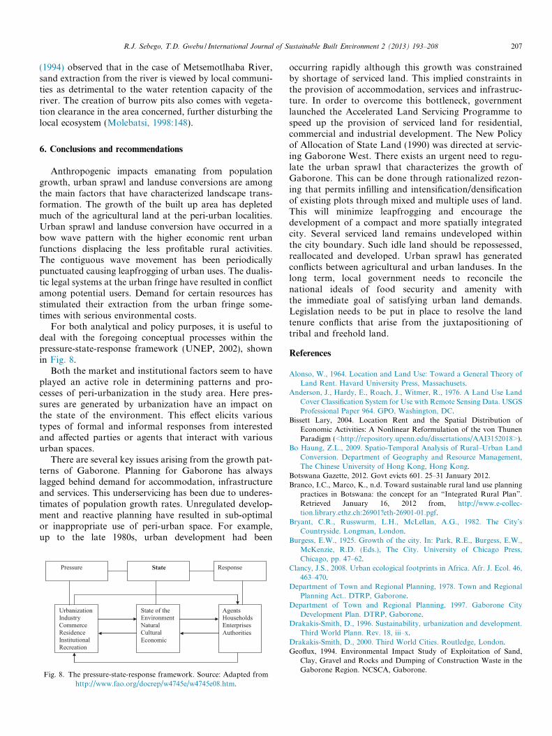
For both analytical and policy purposes, it is useful todeal with the foregoing conceptual processes within thepressure-state-response framework (UNEP, 2002), shownin Fig. 8.
Both the market and institutional factors seem to haveplayed an active role in determining patterns and pro-cesses of peri-urbanization in the study area. Here pres-sures are generated by urbanization have an impact onthe state of the environment. This effect elicits varioustypes of formal and informal responses from interestedand affected parties or agents that interact with variousurban spaces.
There are several key issues arising from the growth pat-terns of Gaborone. Planning for Gaborone has alwayslagged behind demand for accommodation, infrastructureand services. This underservicing has been due to underes-timates of population growth rates. Unregulated develop-ment and reactive planning have resulted in sub-optimalor inappropriate use of peri-urban space. For example,up to the late 1980s, urban development had been
Pressure State Response
UrbanizationIndustry CommerceResidenceInstitutionalRecreation
State of theEnvironment NaturalCultural Economic
AgentsHouseholds EnterprisesAuthorities
Fig. 8. The pressure-state-response framework. Source: Adapted fromhttp://www.fao.org/docrep/w4745e/w4745e08.htm.
occurring rapidly although this growth was constrainedby shortage of serviced land. This implied constraints inthe provision of accommodation, services and infrastruc-ture. In order to overcome this bottleneck, governmentlaunched the Accelerated Land Servicing Programme tospeed up the provision of serviced land for residential,commercial and industrial development. The New Policyof Allocation of State Land (1990) was directed at servic-ing Gaborone West. There exists an urgent need to regu-late the urban sprawl that characterizes the growth ofGaborone. This can be done through rationalized rezon-ing that permits infilling and intensification/densificationof existing plots through mixed and multiple uses of land.This will minimize leapfrogging and encourage thedevelopment of a compact and more spatially integratedcity. Several serviced land remains undeveloped withinthe city boundary. Such idle land should be repossessed,reallocated and developed. Urban sprawl has generatedconflicts between agricultural and urban landuses. In thelong term, local government needs to reconcile thenational ideals of food security and amenity withthe immediate goal of satisfying urban land demands.Legislation needs to be put in place to resolve the landtenure conflicts that arise from the juxtapositioning oftribal and freehold land.
References
Alonso, W., 1964. Location and Land Use: Toward a General Theory ofLand Rent. Havard University Press, Massachusets.
Anderson, J., Hardy, E., Roach, J., Witmer, R., 1976. A Land Use LandCover Classification System for Use with Remote Sensing Data. USGSProfessional Paper 964. GPO, Washington, DC.
Bissett Lary, 2004. Location Rent and the Spatial Distribution ofEconomic Activities: A Nonlinear Reformulation of the von ThunenParadigm (<http://repository.upenn.edu/dissertations/AAI3152018>).
Bo Haung, Z.L., 2009. Spatio-Temporal Analysis of Rural–Urban LandConversion. Department of Geography and Resource Management,The Chinese University of Hong Kong, Hong Kong.
Botswana Gazette, 2012. Govt evicts 601. 25–31 January 2012.Branco, I.C., Marco, K., n.d. Toward sustainable rural land use planning
practices in Botswana: the concept for an “Integrated Rural Plan”.Retrieved January 16, 2012 from, http://www.e-collec-tion.library.ethz.ch:26901?eth-26901-01.pgf.
Bryant, C.R., Russwurm, L.H., McLellan, A.G., 1982. The City’sCountryside. Longman, London.
Burgess, E.W., 1925. Growth of the city. In: Park, R.E., Burgess, E.W.,McKenzie, R.D. (Eds.), The City. University of Chicago Press,Chicago, pp. 47–62.
Clancy, J.S., 2008. Urban ecological footprints in Africa. Afr. J. Ecol. 46,463–470.
Department of Town and Regional Planning, 1978. Town and RegionalPlanning Act.. DTRP, Gaborone.
Department of Town and Regional Planning, 1997. Gaborone CityDevelopment Plan. DTRP, Gaborone.
Drakakis-Smith, D., 1996. Sustainability, urbanization and development.Third World Plann. Rev. 18, iii–x.
Drakakis-Smith, D., 2000. Third World Cities. Routledge, London.Geoflux, 1994. Environmental Impact Study of Exploitation of Sand,
Clay, Gravel and Rocks and Dumping of Construction Waste in theGaborone Region. NCSCA, Gaborone.
208 R.J. Sebego, T.D. Gwebu / International Journal of Sustainable Built Environment 2 (2013) 193–208
Geyer, H., 2003. Differential Urbanization in South Africa-A FurtherExploration. Tijdschrift voor Economische en Sociale Geografie 94,44–59.
Greene, R.P., Pick, J.B., 2006. Exploring the Urban Community: A GISApproach. Prentice Hall, Upper Saddle River, NJ.
Gwebu, T.D., 1987. Spatial organization of urban centers in Botswana:the evolution of development with equity. Afr. Urban Q. 2, 149–160.
Gwebu, T.D., 2002. Localized wood resource depletion in Botswana:towards a demographic, institutional and cosmovisional explanation.Ethics Place Environ. 5, 144–152.
Gwebu, T.D., 2006. Towards a theoretical exploration of the differentialurbanization model in sub-Saharan Africa: the Botswana case.Tijdschrift voor Economische en Sociale Geografie 97, 418–433.
Gwebu, Thando D., 2012. Botswana’s mining path to urbanisation andpoverty alleviation. J. Contemp. Afr. Stud. 30, 611–630.
Hart, J.F., 1991. The perimetropolitan bow wave. Geog. Rev. 81, 35–51.Ikgopoleng, S., Musisi, N., Chanda, R., 2011. Landuse, policy, and
squatter settlement: the case of peri-urban in Botswana. J. Appl.Geogr. 31 (2), 677–686.
Kalabamu, F., Morolong, S., 2004. Informal Land Delivery Processes andAccess to Land for the Poor in Gaborone, Botswana. University ofBirmingham, Birmingham.
Killick, T., 2008. Development planning in Africa: experiences, weak-nesses and prescriptions. Dev. Policy Rev. 1, 47–76.
Lipsey, R.G., 1975. An Introduction to Positive Economics. Weidenfeld &Nicolson, London.
Lovett, J.C., 2008. Urbanisation and over-population. Afr. J. Ecol. 46,461–462.
The Sunday Standard Newspaper, 18 May 2012, 29 (73).Molebatsi, C.O., 1998. Urban environmental problems in Botswana. In:
Atlhopheng, J., Molebatsi, C., Toteng, E., Totolo, O. (Eds.),Environmental Issues in Botswana: A Handbook. Lightbooks,Gaborone.
Mpofu, G., 2010. Indiscriminate Dumping of Building Rubble in OpenSpaces: A Case Study of Mogoditshane Village (Unpublished B.A.dissertation). University of Botswana, Department of EnvironmentalScience.
Nkambwe, M., 2003. Contrasting land tenures: subsistence agricultureversus urban expansion on the rural–urban fringe of Gaborone,Botswana. Int. Dev. Rev. 25 (4), 391–405.
Nkambwe, M., Totolo, O., 2005. Customary land tenure saves the bestarable agricultural land in the peri-urban zones of an African city:Gaborone, Botswana. Appl. Geogr. 25, 29–46.
Republic of Botswana (ROB), 2004. National Population Policy. Ministryof Finance and Development Planning, Gaborone.
Silitshena, R.M.K., 1996. Urban environmental management and issues inAfrica south of the Sahara. In: Benneh, G., Morgan, W.B., Uitto, J.I.(Eds.), Sustaining the Future. Economic, Social and EnvironmentalChange in sub-Saharan Africa. United Nations University Press, NewYork.
Speigel, H.W., 1971. The Growth of Economic Thought. Prentice Hall,New Jersey.
Toteng, E.N., 2001. Urban Environmental Management in Botswana:Toward a Theoretical Explanation of Public Policy Failure. Environ-mental Management 28, 19–30.
United Nations, 2004. Botswana Millennium Development Goals. UN,Gaborone.
von Benda-Beckmann, Franz, 2002. Who’s afraid of legal pluralism? J.Legal Pluralism. 47, 37–83.
Wekwete, K.H., 1995. Planning law in Sub-Saharan Africa—a focus onthe experiences in Southern and Eastern Africa. Habitat International19 (1), 13–28.
Wily, A., 1999. Land tenure reform and balance of power in Eastern andSouthern Africa. In: Natural Resource Perspectives No. 58. ODI/DFID.