patrick abercrombie final (2003) ppt
TRANSCRIPT

BHAIRAVI BHATIA

BHAIRAVI BHATIA
TABLE OF CONTENTS:
HISTORY OF TOWN PLANNING IN LONDON
CHRISTOPHER WREN’S PLAN
PATRICK ABERCROMBIE’S PLAN - WORLD WAR II AND BARLOW COMISSION
- COUNTY OF LONDON PLAN- GREATER LONDON PLAN- OPEN SPACE PLAN- ROAD LAYOUT- RIVERSIDE DEVELOPMENT
CURRENT SCENARIO- KEY DIAGRAM- SOCIAL AND ECONOMIC GROWTH AND DISTRIBUTION- SUSTAINABLE DEVELOPMENT- NEIGHBOURHOODS AND COMMUNITY DWELLINGS
CONCLUSION

BHAIRAVI BHATIA

BHAIRAVI BHATIA
Fields Achitecture, physics, astronomy and maths.
Alma Mater Wadham college, University of Oxford
Known for
Designer of 54 churches including St. Paul’s Cathedral, as well as many secular buildings of note in London after the Great Fire
IN SEPTEMBER 1666, THE “GREAT FIRE " DESTROYED 1/3RD OF BUILDINGS IN LONDON• CHRISTOPHER WREN PROPOSED AN AMBITIOUS PLAN THAT WOULD REBUILD LONDON WITH WIDE STREETS RADIATING FROM A CENTRAL HUB. • WREN'S PLAN FAILED, PROBABLY BECAUSE PROPERTY OWNERS WANTED TO KEEP THE SAME LAND THEY OWNED BEFORE THE FIRE. • BUT WREN DID DESIGN 51 NEW CITY CHURCHES AND THE ROYAL WORKS (GOVERNMENT BUILDINGS).
I:\london\Christopher Wren - Wikipedia, the free encyclopedia.mht
SIR CHRISTOPHER WREN AND THE GREAT FIRE OF LONDON:
BHAIRAVI BHATIA
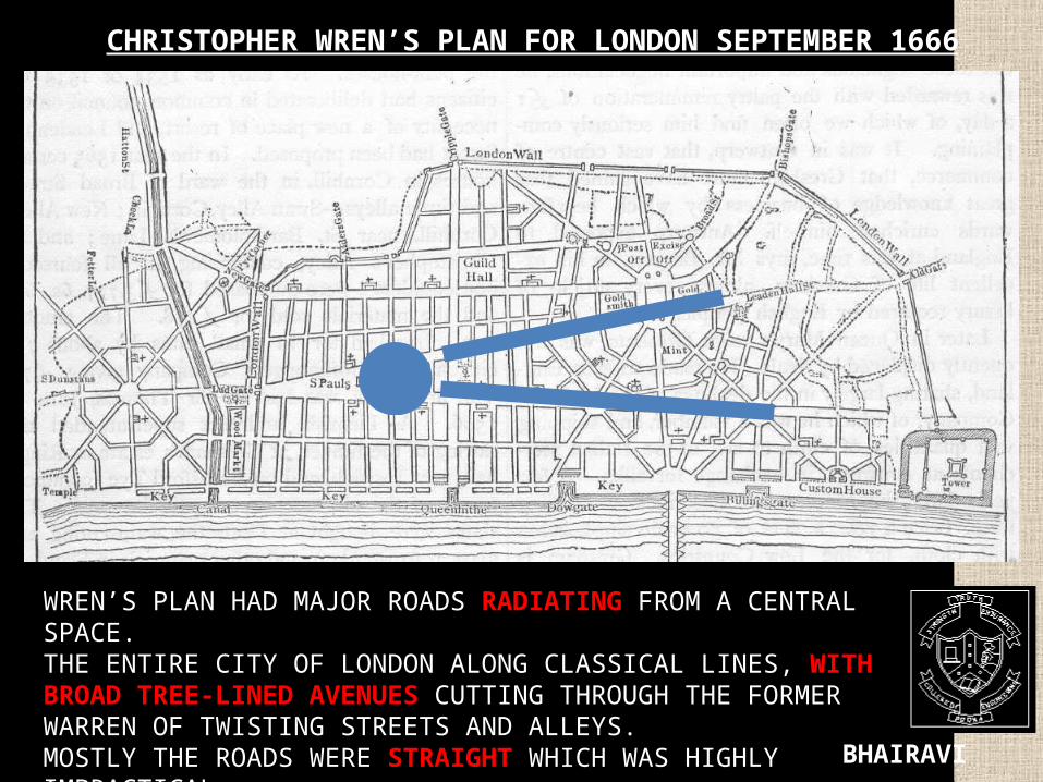
CHRISTOPHER WREN’S PLAN FOR LONDON SEPTEMBER 1666
WREN’S PLAN HAD MAJOR ROADS RADIATING FROM A CENTRAL SPACE.THE ENTIRE CITY OF LONDON ALONG CLASSICAL LINES, WITH BROAD TREE-LINED AVENUES CUTTING THROUGH THE FORMER WARREN OF TWISTING STREETS AND ALLEYS.MOSTLY THE ROADS WERE STRAIGHT WHICH WAS HIGHLY IMPRACTICAL

BHAIRAVI BHATIA
WREN’S PRINCIPLES:
1. "ARCHITECTURE HAS ITS POLITICAL USE; PUBLIC BUILDINGS BEING THE ORNAMENT OF A COUNTRY;
2. THE RULES OF OPTICS AND GEOMETRY SHOULD BE USED WHILE PLANNING THE CITY AND FOR ADDING VARIETY INTO IT.
I:\london\Sir Christopher Wren - Architect Who Rebuilt London Sir Christopher Wren.mht
WREN’S PLAN CONSISTS OF A SKELETON OF MAIN STREETS LINKING UP SEVERAL ‘ROUNDS-POINTS’ WHIERE SECONDARY STREETS RADIATE, WHILE A GRID OF STILL NARROWER STREETS FILLS THE SPACES.'
WREN’S PLAN FOR LONDON WAS AN INSPIRATION FROM GARDEN OF VERSAILLES.
BHAIRAVI BHATIA
1800
1880
1958
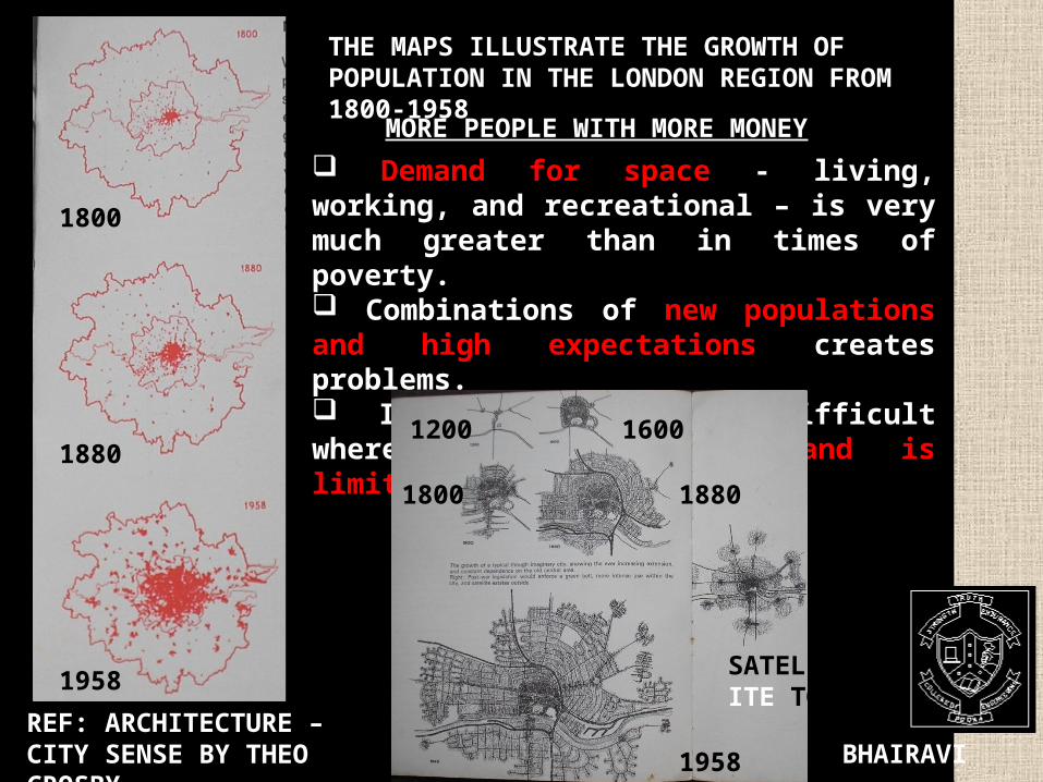
THE MAPS ILLUSTRATE THE GROWTH OF POPULATION IN THE LONDON REGION FROM 1800-1958
REF: ARCHITECTURE – CITY SENSE BY THEO CROSBY
Demand for space - living, working, and recreational – is very much greater than in times of poverty. Combinations of new populations and high expectations creates problems. It is particularly difficult where the amount of land is limited.
MORE PEOPLE WITH MORE MONEY
1200 1600
1800 1880
1958
SATELL ITE TOWN
BHAIRAVI BHATIA
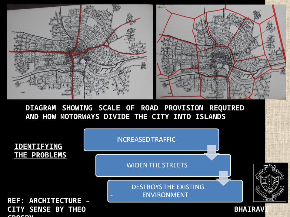
DIAGRAM SHOWING SCALE OF ROAD PROVISION REQUIRED AND HOW MOTORWAYS DIVIDE THE CITY INTO ISLANDS
REF: ARCHITECTURE – CITY SENSE BY THEO CROSBY
IDENTIFYING THE PROBLEMS
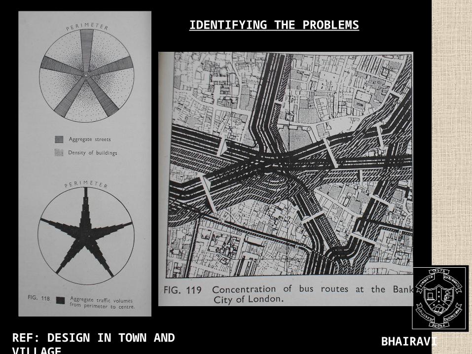
BHAIRAVI BHATIAREF: DESIGN IN TOWN AND VILLAGE
IDENTIFYING THE PROBLEMS

BHAIRAVI BHATIA
Wartime and Post-War British Planning: Abercrombie
• Patrick Abercrombie
• The Barlow Commission
and World War II
• The Plan for Greater
London and Britain’s New
Towns Program
Read more: Sir Patrick Abercrombie — Infoplease.com http://www.infoplease.com/ce6/people/A0802133.html#ixzz0wIIXBm00

BHAIRAVI BHATIA
The bright red indicates the areas of London that contained industry at this point in 1943. There is a significant amount of red concentrated around the Thames – before the war there was still much heavy industry concentrated around the East End.
I:\london\Patrick Abercrombie.mht
PLAN SHOWING CONCENTRATION OF INDUSTRIES IN LONDON

BHAIRAVI BHATIA
CAREER•AN ARCHITECT THEN PROFESSOR OF CIVIC DESIGN AT LIVERPOOL UNIVERSITY SCHOOL OF ARCHITECTURE IN 1915,• LATER PROFESSOR OF TOWN PLANNING AT UNIVERSITY COLLEGE LONDON. WORKS• DESIGNS FOR DUBLINCITY CENTRE • REPLANNING OF PLYMOUTH, HULL, BATH, EDINBURG AND BOURNEMOUTH.• INVOLVED IN FOUNDING OF THE COUNCIL FOR THE PRESERVATION OF RURAL ENGLAND (CPRE). • BEST KNOWN FOR THE POST – SECOND WORLD WAR REPLANNING OF LONDON.• CREATED COUNTY OF LONDON PLAN (1943) AND GREATER LONDON PLAN (1944)• PUBLISHED A PLAN FOR THE CITY & COUNTY OF KINGSTON UPON HULL (1945), WITH THE ASSISTANCE OF SIR EDWYN LUTENS. • FROM THE ABERCROMBIE PLAN , CAME THE NEW TOWN MOVEMENT.

BHAIRAVI BHATIA
ACHIEVEMENTS IN EUROPE
• ENGLISH NEW TOWN MOVEMENT – Sir Anthony Barlow headed commission “The Report of Royal Commission of Distribution of Industrial Population” (1940) -- Sir Patrick Abercrombie and J.H. Forshaw “The County of London Plan” (1943) -- “New Towns” – Plan of Hook; Plan of Cumbernauld • OTHER DEVELOPMENTS – London’s Barbican area -- Garden cities in France
-- Dourges – 1st garden city in France (1919)-- Longueau, Tergnier, Lille-le-Deliverance
-- Berlin, Germany – Martin Machler -- Baku in Russia -- West Kungsholmen, Stockholm -- Tapiola, Helsinki in Finland -- Amsterdam South, Amsterdam in Holland -- Other countries – Italy, Switzerland, Israel

BHAIRAVI BHATIA
Professor Patrick Abercrombie (1879-1957) was a trained architect and town planner. He prepared the 'COUNTY OF LONDON PLAN' (1943) AND THE GREATER LONDON PLAN (1944) during the Second World War as a blueprint for London's post-war reconstruction and development.
GREATER LONDON MODEL
I:\london\Abercrombie Plan 1944 - Exploring 20th Century London.mht

BHAIRAVI BHATIA
He established 'Standards of Open Space' which recommended that, for every thousand city inhabitants, there should be at least four acres of open space available.
Land used for allotments during the war and bomb-damaged areas presented a post-war opportunity for a network of open spaces that Abercrombie hoped would contribute to the improvement of people's health and wellbeing.

BHAIRAVI BHATIA
ABERCROMBIE’S CONCEPT Controlled growth was for Abercrombie the SPIDER-WEB TYPE of development, It combined features of SPONTANEOUS RIBBON DEVELOPMENT, growing like tentacles from a common nucleus, and from GRID PLAN
It symbolised the MUTUAL ADJUSTMENT of nature and culture, man and environment.

BHAIRAVI BHATIA
COUNTY OF LONDON PLAN
BHAIRAVI BHATIA
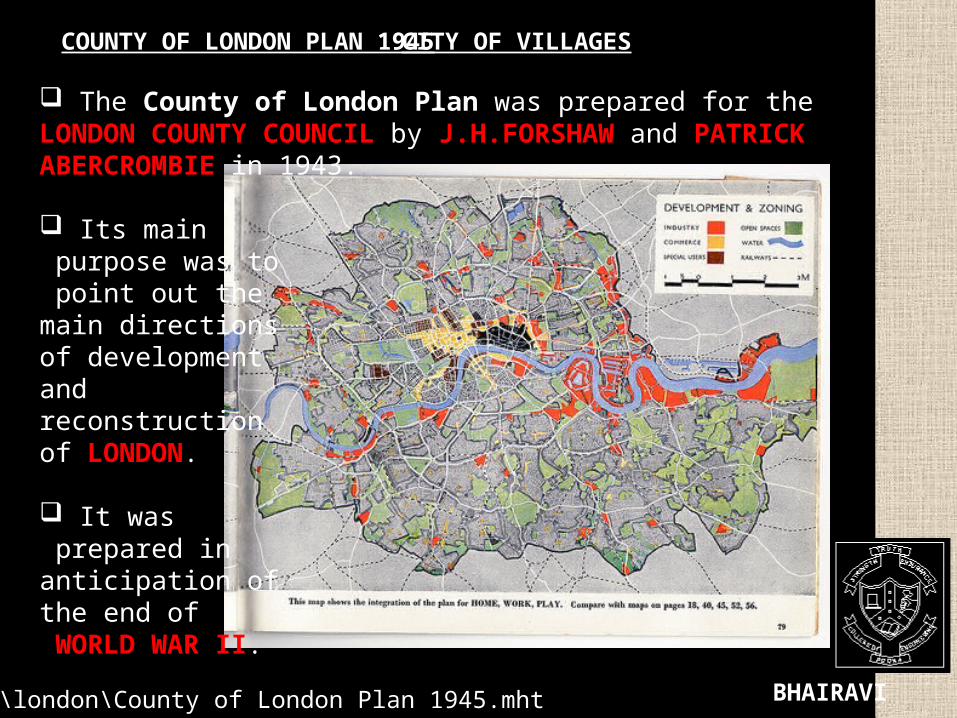
COUNTY OF LONDON PLAN 1945 CITY OF VILLAGES
I:\london\County of London Plan 1945.mht
The County of London Plan was prepared for the LONDON COUNTY COUNCIL by J.H.FORSHAW and PATRICK ABERCROMBIE in 1943.
Its main purpose was to point out the main directions of development and reconstruction of LONDON.
It was prepared in anticipation of the end of WORLD WAR II.

BHAIRAVI BHATIA
THE COUNTY OF LONDON PLAN, 1943
The London County Council tasked JH Forshaw, its resident architect, and Patrick Abercrombie with drawing up a comprehensive plan for the old County of London.
They identified London's FOUR "MAJOR DEFECTS" as
- Traffic congestion, - Depressed housing, - Inadequacy and mal-distribution of open spaces, and - The jumble of houses and industry ("indeterminate zoning").

BHAIRAVI BHATIA
The road plan had three classifications of road:
FEATURES OF THIS CLASSIFICATION -All through traffic onto arterial roads, - Travelling long distances by local roads not possible, as they would be effectively blocked off from through traffic. - Areas within the grid would be as self-contained as possible, to reduce the demand for travel. - This led to invention of system of RING ROADS.

BHAIRAVI BHATIA
The B-Ring, the principal ring road around central London, built for fast traffic. It was to be fully grade-separated There were three grades.
-SURFACE LEVEL ROAD- HIGH LEVEL ROAD - LOW LEVEL ROAD

BHAIRAVI BHATIA
• THE A-RING, LINKED THE MAJOR RAILWAY TERMINI, AND FORMED "THE BOUNDARY OF THE EMPIRE, CULTURAL AND COMMERCIAL CORE OF LONDON“. • THE C-RING, OTHER RADIALS AND SOME CONNECTING ROADS.• THE D-RING, AN EXPRESS-ARTERIAL, AND ALMOST ENTIRELY A NEW ROUTE. THIS WAS INTENDED TO "GIRDLE THE GENERAL LIMITS OF THE BUILT-UP AREA IN LONDON", IN CONJUNCTION WITH THE GREEN BELT. • THE E-RING, ANOTHER SUB-ARTERIAL, WOULD BE A PARKWAY, WITH FREQUENT LAYBYS AND PICNIC AREAS. THE E-RING DID NOT JOIN UP ACROSS THE THAMES.

BHAIRAVI BHATIA
EXPRESS ARTERIAL ROUTESAbercrombie's proposals for motorway-style routes were as follows:
The Plan detailed three styles of grade-separated junction: the two-level roundabout interchange; the three-level roundabout interchange the cloverleaf. Abercrombie was careful to note that he had modified the latter to turn the four round loops into triangular roadways with sharp corners,

BHAIRAVI BHATIA
THE ABERCROMBIE PLAN
1. RECONSTRUCTION OF INNER LONDON
2. THE NEW TOWNS CREATED BEYOND THE GREEN BELT
CONCENTRIC RING THEORY
SUB-URBS/ SATELLITE TOWNS
C.B.D.
RESIDENCES

BHAIRAVI BHATIA
The Greater London Plan, 1944

BHAIRAVI BHATIA

BHAIRAVI BHATIA
• THE RIVERSIDE WALK IS VERY DIVERSE.• IT LEAVES THE RIVER FOR SHORT SECTIONS .• THEY LINK ORIGINS TO DESTINATIONS .• THE WALKWAY IS A GREAT LANDSCAPE PLANNING ACHIEVEMENT
FILE:///I:/LONDON/LONDON'S%20RIVERSIDE%20LANDSCAPE%20%20GARDENVISIT_COM,%20THE%20GARDEN%20LANDSCAPE%20GUIDE.MHT#IXZZ0Y18ZURV9

BHAIRAVI BHATIA
OPEN SPACE PLAN 1944 ABERCROMBIE PARK SYSTEM. BOMBS DROPPED ON LONDON
The idea was to create a web of open space leading from the city centre, through green corridors, greenways and green wedges to a green belt on the periphery of London. Beyond the Green Belt, Abercrombie proposed the layout of New Towns.file:///I:/london/A%20Biography%20of%20Patrick%20Abercrombie.mht#ixzz0y08XUs2u
“Adequate open space for both recreation and rest is a vital factor in maintaining and improving the health of the people”, begins the ‘Abercrombie Plan’. It’s at once a visionary plan, in that it creates a coordinated Park System.

BHAIRAVI BHATIA
Abercrombie proposed a ‘standard of open space’ of 1.62 hectares (or four acres) per 1000 people. These spaces need to be considered as a whole, and co-ordinated into a closely-linked park system, with parkways along existing and new roads forming the links between larger parks. The goal was that city-dwellers could “get from their doorstep to open country through an easy flow of open space from garden to park, from park to parkway, from parkway to green wedge and from green wedge to green belt.” Abercrombie identified seven categories of parkways : 1. linear strips of open space;2. riverside walks;3. footpaths through farmland; 4.bridle tracks and green lanes; 5.bicycle tracks; 6.motor parkways; and 7.express arterial roads.
In the plan, a Green Belt Ring of about 8 kilometres deep would be used for recreational purposes, with a mainly agricultural Outer Country Ring. In both rings, no new building would be allowed and an extensive system of radial and connecting footpaths was to be created.

BHAIRAVI BHATIA

BHAIRAVI BHATIA
Creating mechanisms to ensure that development and services meet local people’s needs, and that people are empowered to take their own decisions at the neighbourhood level, will be vital to creating vibrant neighbourhoods and a sense of community.
COMMUNITIES, NEIGHBOURHOODS AND THE DEVELOPMENT PROCESS
Design in town and village

BHAIRAVI BHATIA
The methods adopted to form spaces with small houses:1.Make recessions in the street length2. group the buildings around road intersections3. design short length of street as a space – culdesac4. form spaces or closes independent of road system All the methods depend upon the visual perceptions

BHAIRAVI BHATIA
A SKETCH DIAGRAM SHOWING THE PROBABLE GROWTH OF SATELLITE TOWNS AROUND LONDON.
THESE INCLUDED STEVENAGE, HARLOW, CRAWLEY AND HAROLD HILL.

BHAIRAVI BHATIA
BHAIRAVI BHATIA

BHAIRAVI BHATIA
MAP 5A.1 – LONDON’S SUB-REGIONS
Outer London, Inner London and Central Activities Zone

BHAIRAVI BHATIA
MAP 1.1 POPULATION GROWTH 1991 - 2003

BHAIRAVI BHATIA
MAP 1.2 JOBS GROWTH 1991 - 2003

BHAIRAVI BHATIA
FIGURE 1.1 LONDON’S POPULATION CHANGE: ACTUAL AND PROJECTED 1971 - 2026
Sources: Estimates: 1939 National Registration; 1951 Census; 1961-2001 ONS Mid-yearEstimates.Projections: GLA DMAG 2005 Round Projections 2002-2026.

BHAIRAVI BHATIA
MAP 2A. 1 OPPORTUNITY AREAS
BHAIRAVI BHATIA
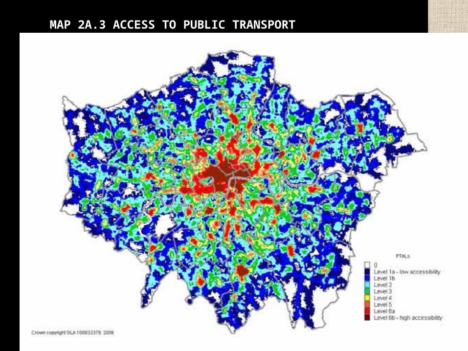
MAP 2A.3 ACCESS TO PUBLIC TRANSPORT
BHAIRAVI BHATIA
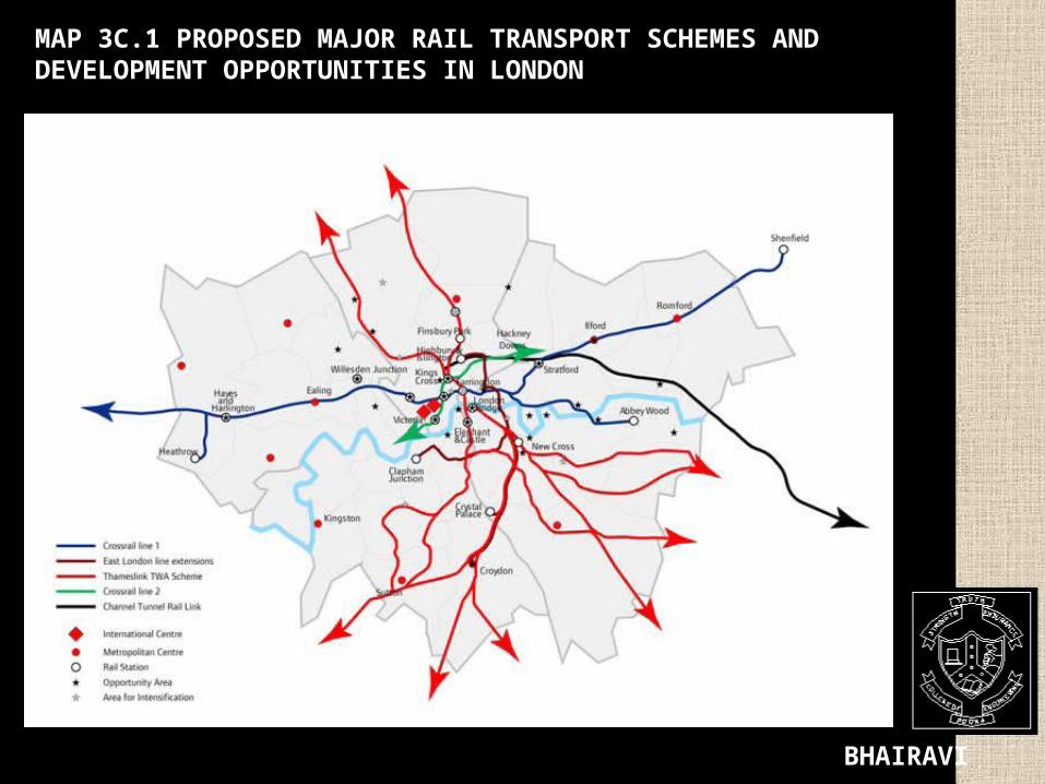
MAP 3C.1 PROPOSED MAJOR RAIL TRANSPORT SCHEMES AND DEVELOPMENT OPPORTUNITIES IN LONDON

BHAIRAVI BHATIA
MAP 3C.2 PROPOSED LIGHT TRANSIT SCHEMES IN LONDON

BHAIRAVI BHATIA
MAP 3C.3 PROPOSED RIVER CROSSING SCHEMES
BHAIRAVI BHATIA
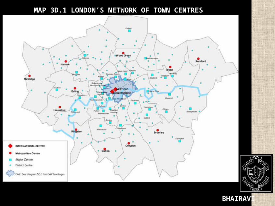
MAP 3D.1 LONDON’S NETWORK OF TOWN CENTRES
BHAIRAVI BHATIA
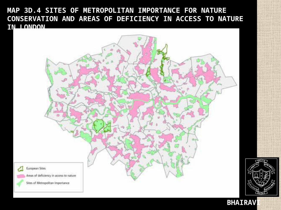
MAP 3D.4 SITES OF METROPOLITAN IMPORTANCE FOR NATURE CONSERVATION AND AREAS OF DEFICIENCY IN ACCESS TO NATURE IN LONDON

BHAIRAVI BHATIA
NEW MAP 3D.5 IMPORTANT SITES OF GEOLOGICAL INTEREST IN LONDON

BHAIRAVI BHATIA
NEW MAP 4A.1I SPATIAL DISTRIBUTION OF BROAD LOCATIONS SUITABLE FOR RECYCLING AND WASTE TREATMENT FACILITIES

BHAIRAVI BHATIA
The Blue Ribbon Plan, or London Rivers Open Space Plan, was the first significant statement on Open Space Planning in the Twenty First Century by the Greater London Authority.
file:///I:/london/The%20Greater%20London%20Authority's%202004%20London%20Plan%20%20GardenVisit_com,%20the%20garden%20landscape%20guide.mht#ixzz0y0GB1qlB
The Blue Ribbon Plan is one component of what should be a large-scale plan for London's Green Infrastructure. As Abercrombie proposed in 1943-4, the Green Infrastructure should extend from Central London into the Green Belt and the surrounding countryside. If, as must be expected, London continues to grow, then the Rural Green Infrastructure will become Urban Green Infrastructure.
BHAIRAVI BHATIA
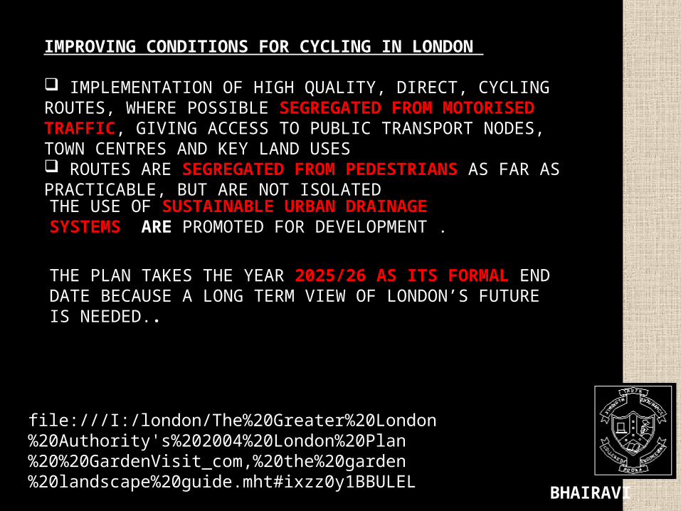
THE PLAN TAKES THE YEAR 2025/26 AS ITS FORMAL END DATE BECAUSE A LONG TERM VIEW OF LONDON’S FUTURE IS NEEDED..
IMPROVING CONDITIONS FOR CYCLING IN LONDON
IMPLEMENTATION OF HIGH QUALITY, DIRECT, CYCLING ROUTES, WHERE POSSIBLE SEGREGATED FROM MOTORISED TRAFFIC, GIVING ACCESS TO PUBLIC TRANSPORT NODES, TOWN CENTRES AND KEY LAND USES ROUTES ARE SEGREGATED FROM PEDESTRIANS AS FAR AS PRACTICABLE, BUT ARE NOT ISOLATED
file:///I:/london/The%20Greater%20London%20Authority's%202004%20London%20Plan%20%20GardenVisit_com,%20the%20garden%20landscape%20guide.mht#ixzz0y1BBULEL
THE USE OF SUSTAINABLE URBAN DRAINAGE SYSTEMS ARE PROMOTED FOR DEVELOPMENT .

BHAIRAVI BHATIA
PATRICK ABERCROMBIE WAS A GREAT VISIONARY. HE FOLLOWED SURVEY-BASED PLANNING PHILOSOPHY HE IDENTIFIED THE PROBLEMS BEFORE PLANNING. ESTABLISHED A BALANCE BETWEEN THE COMPETING
DEMANDS OF ARCHITECTURE AND LANDSCAPE. HE BELIEVED IN THE CONCENTRIC SECTOR THEORY ALONGWITH THE PROVISION
OF SATELLITE TOWNS FOR A CITY’S EXPANSION. HE CHAMPIONED THE IDEA OF A GREEN BELT AROUND LONDON. PROVIDING LINKING PARKWAYS HE EXTENDED THE RADIUS OF INFLUENCE OF
THE LARGER OPEN SPACES HE BROUGHT THE OPEN SPACES INTO MORE INTIMATE RELATIONSHIP WITH THE
SURROUNDING AREAS. HE DESIGNED FOR THE MOTOR AGE TRYING TO REDUCE THE TRAFFIC
CONGESTIONS. A CITY WITH DIVERSE SUBURBAN ENVIRONMENTS THAT OFFER MANY PEOPLE A
HIGH QUALITY OF LIFE. THE FUTURE SCALE AND PHASING OF DEVELOPMENT SHOULD BE INTEGRATED
WITH THE CAPACITY OF THE PUBLIC TRANSPORT SYSTEM AND ACCESSIBILITY OF DIFFERENT LOCATIONS.
MAINTAINED HEIRARCHY OF ROADS. SUSTAINABLE DEVELOPMENT AS LESS NEED TO TRAVEL FROM HOME
TO WORK
CONCLUSION

BHAIRAVI BHATIA
OPEN SPACES, RIVERS AND OTHER WATER FEATURES SHOULD BE PROTECTED AND ENHANCED SO THAT GROWTH CAN BENEFIT THE CITY’S BREATHING SPACES.
EQUALLY THE QUALITY OF BUILT ENVIRONMENT IS ENHANCED, SO THAT A MORE DYNAMIC AND ACTIVE CITY CAN ALSO ENJOY MORE ATTRACTIVE SURROUNDINGS.
LONDON HAS GROWN AS A RELATIVELY LOW DENSITY, OPEN CITY COMPARED TO OTHER WORLD CITIES .
LONDON HAS A WELL-ESTABLISHED PATTERN OF CENTRES VARYING IN SIZE LEADING IT TO BEING ‘POLY-CENTRIC’ .
THIS HELPS TO DISTRIBUTE THE POPULATION RATHER THAN CONCENTRATION AND CONGESTION.
TWO-THIRDS OF ITS LAND AREA AND THE MAJORITY OF ITS POPULATION AND WORKFORCE ARE IN THE SUBURBS.
IT HAS AN ATTRACTIVE NETWORK OF OPEN AND WATER SPACES. IT ACCOMMODATES GROWTH WITHIN ITS BOUNDARIES WITHOUT
ENCROACHING ON OPEN SPACES. IT IS A WELL-DESIGNED AND GREEN CITY. LONDON PLAN ESTABLISHES A HIERARCHY OF OPEN SPACES OF DIFFERENT
SIZE WITH GREEN CHAINS TO PROMOTE BIODIVERSITY

BHAIRAVI BHATIA

BHAIRAVI BHATIA