pastoral utilization and land cover change: a case … · pastoral utilization during the summers...
TRANSCRIPT

1 Introduction and objectives
Management systems and changes in the intensity ofpastoral utilization are widely recognized as key issuesof integrated and applied research on African range-lands. The contemporary debate focuses on topics suchas sustainability of indigenous range management stra-tegies, legitimacy of transhumance, and ecological out-comes such as land cover change and environmentaldegradation. Classic concepts, based on assumptions ofstability and equilibrium of ecological carrying capa-city, have provided the standard by which many range-lands are considered overstocked and deteriorated.This conventional view stresses the destructive poten-tial of mobile livestock keeping and the need for controlof animal numbers and herd movements. Especially inthe case of rangelands managed under traditional com-mon property regimes, land mismanagement and sub-sequent land degradation are typically attributed to pastoralism. The theoretical framework is based on the‘tragedy of the commons’ paradigm (HARDIN 1968),which serves as an underlying key model to describe
resource degradation as a consequence of many indivi-duals using scarce resources in common.
A number of recent studies (e.g. SCOONES 1995;LEACH a. MEARNS 1996; NIAMIR-FULLER 1999) chal-lenge these core conjectures for the semiarid range-lands and thus give way to a ‘new paradigm’ in the assessment of pastoral development in Africa. Produc-tion potentials of semiarid rangelands are generallycharacterized by non-equilibrium dynamic patterns(BEHNKE a. SCOONES 1993; BEHNKE a. ABEL 1996) dueto high levels of inter-annual variability of precipita-tion with frequent droughts and other unpredictablefactors. Therefore, prognostic scenarios and explana-tions of calamities primarily based on concepts of eco-logical carrying capacity are often insufficient. Appa-rently, most classic approaches tend to neglect issuessuch as indigenous knowledge in range managementand do not recognize the necessities and particularitiesof livelihood strategies under conditions of uncertainty(e.g. PERRIER 1995; SANDFORD 1995; SCOONES 1996).More recent approaches on ‘governing the commons’(OSTROM 1990) put particular emphasis on understand-
Marcus Nüsser: Pastoral utilization and land cover change: a case study from the Sanquebethu Valley, eastern Lesotho 207
PASTORAL UTILIZATION AND LAND COVER CHANGE:A CASE STUDY FROM THE SANQEBETHU VALLEY, EASTERN LESOTHO
With 5 figures, 3 tables, 4 photos and 1 Supplement (III – Fig. 2)
MARCUS NÜSSER
Zusammenfassung: Weidenutzung und Landschaftsveränderungen: Ein Fallbeispiel aus dem Sanqebethu-Tal im östlichen Lesotho
Seit der Kolonialzeit gilt das Königreich Lesotho als ein bekanntes Beispiel für weitflächige Landdegradation. Als Folge an-haltend hoher Nutzungsintensität, vornehmlich in Form von Beweidung, Brand des Graslandes und Sammlung von Brenn-holz, werden die agraren Ressourcenpotenziale während der vergangenen Jahrzehnte mit verstärkter Bodenerosion und massiver Degradation der Weideflächen konfrontiert. Am Beispiel des Sanqebethu-Tales im östlichen Hochland von Lesotho(Mokhotlong Distrikt) behandelt dieser Beitrag die jüngere Entwicklung von Ressourcennutzungsmustern und weide-wirtschaftlicher Nutzungsintensität sowie die daraus resultierenden Vegetations- und Landschaftsveränderungen. Gestützt aufaktuelle Feldbefunde, Vergleichsdaten des Jahres 1988 und eine multitemporale Analyse von Satellitendaten des Sensors Land-sat TM werden die Situationen in den Jahren 1988/89 und 1999 gegenübergestellt und vergleichend interpretiert. Trotz einesdeutlichen Rückgangs der Weidenutzung zwischen diesen beiden Zeitschnitten zeigt sich eine leichte Abnahme der Vegeta-tionsbedeckung im Bereich des Höhengraslandes. Die Ergebnisse werden vor dem Hintergrund aktueller weideökologischerund theoretischer Konzepte diskutiert.
Summary: Since colonial times, the mountain kingdom of Lesotho has served as a prominent example for widespread landdegradation. Over the last decades, land use has been confronted with accelerated soil erosion, turf loss and grassland degra-dation as a result of a generally high and continuous anthropo-zoogenic impact, e.g. grazing, grassland burning and fuelwoodcollection. Based on a comparative approach, this paper analyses recent developments of pastoral resource utilization and subsequent vegetation change in the Sanqebethu Valley, situated in the eastern highlands of Lesotho (Mokhotlong District).The assessment of contemporary land use and land cover change is based on a time series of remote sensing data (LandsatTM) from 1989 and 1999, a recent ground survey and comparative data from 1988. High altitude grasslands show a slight reduction of vegetation cover, although the general intensity of pastoral utilization decreased significantly in the interim decade. The results are discussed with regard to recent pasture-ecological and theoretical concepts.

ing indigenous rules and regulations in the manage-ment of common property regimes.
As uncertainties prevail about the extent of environ-mental degradation and the role of local communitiesin fostering landscape changes, integrated case studiesare required to identify and account for the frequencyand magnitude of land use and land cover change.1)
The small and land-locked mountain kingdom ofLesotho (30,355 km2), formerly the British protectorateof Basutoland (1884–1966)2), is regarded as a prominentexample of widespread environmental degradation.The decreasing agrarian production potential and degradation of cultivated areas and pastures is indicat-ed by accelerated soil erosion and turf loss. Annual loss of arable land is estimated to reach an area of1,000 hectares (GAY et al. 1995, 51). According to thisfigure the arable land of Lesotho shrank from 9% to 8% of the total area between 1994 and 2001. Takinginto account the recent population growth of 2.6% peryear (CHAKELA 1999, 206), population density of Leso-tho had increased to 800 people per hectare of arableland in 1997. Continuous pressure on the agrarian resources and rapid expansion of settlements duringthe past century challenge developmental perspectivesof land use systems and raise questions about con-temporary land cover change and sustainability.
The high altitude vegetation of Lesotho is one of thecountry’s most valuable resources for the subsistence ofthe local population and a key issue for the regional hydrology of the mountain catchments (GROBBELAAR
a. STEGMANN 1987; MORRIS a. GRAB 1997). A betterunderstanding of resource management systems andland cover change requires an integrated research per-spective, which takes into account issues such as envi-ronmental conditions, natural hazards, regional live-lihood strategies and external influences (NÜSSER 2000;GRAB a. NÜSSER 2001).
The present study comprises an assessment of con-temporary changes in pastoral utilization and corre-sponding changes of vegetation status and land cover inthe catchment area of the upper Sanqebethu River(Mokhotlong District, eastern Lesotho). The focus is onthe situation and conditions in 1988/89 and 1999. The
upper Sanqebethu Valley is selected as a case study region in order to reassess sites which have been studiedin 1988 within the South African ‘Drakensberg/MalutiMountain Catchment Conservation Programme’(MORRIS et al. 1989; QUINLAN 1989; BAINBRIDGE et al.1991).3) Especially the detailed grazing inventories car-ried out by QUINLAN (1989) and by the Range Mana-gement Division of Lesotho (1991) serve as a valuabledatabase for comparative studies. The primary goal ofrecent fieldwork is to provide detailed information onthe intensity and development of pastoral utilization(livestock units, stocking densities), the distribution andfunctional differentiation of grazing posts (location, uti-lization period) and the pastoral migration patterns(seasonal mobility, daily grazing). The intensities ofpastoral utilization during the summers and winters of1999 are investigated, mapped and quantified in orderto collate them with respective data from 1988. Further-more, comparative analyses of matched satellite im-agery from 1989 and 1999 enable correlations between pastoral utilization and land cover change to be made.
2 Study area: location, accessibility and environmental setting
The undulating mountain plateau of eastern Lesotho is bounded by the rugged barrier of the HighDrakensberg, the most prominent part of the Great Escarpment. This continental watershed also marks theboundary between Lesotho and KwaZulu/Natal, aprovince of the Republic of South Africa (Fig. 1). Com-prising the easternmost part of the Lesotho highlands,the study area extends between 29°15’–29°22’S and29°15’–29°27’E. It encompasses the uppermost villa-ges and cultivated areas of the Sanqebethu Valley with its upper tributaries Jareteng, Langa-le-balele,Mahlabachana, Merareng and Moiteling to the east,and the uppermost Mokhotlong Valley to the south-east. The topography of the region is markedly moun-tainous, encompassing ranges that reach elevationsabove 3300 m, and the deeply incised Sanqebethu Val-ley between 2400 and 2750 m (Photo 1). At the south-eastern edge of the study area, Giant’s Castle (3314 m)separates the north-east-facing portion (Northern Berg)of the High Drakensberg, from its south-east-facingpart (Southern Berg).
208 Erdkunde Band 56/2002
1) The international LUCC programme (Land Use andLand Cover Change) studies causes, patterns and rates ofland use change and subsequent landscape transformation(e.g. TURNER et al. 1994; TURNER 1997; LAMBIN et al. 1999).Apparently, the analysis of these issues needs to integrate specific aspects of the regional socio-economic, cultural and political context (GEIST 1999; EHLERS 2000).
2) The indigenous people of Lesotho call themselves Basotho.
3) This multi-disciplinary research and resource planningproject was co-ordinated by the Natal Parks Board (since1998 KwaZulu/Natal Nature Conservation Service) in SouthAfrica and the Range Management Division, Ministry ofAgriculture in Lesotho.

Towards South Africa, the Giant’s Castle Game Reserve (34,638 ha), one of the provinces’ oldest naturereserves (proclaimed in 1907) within the present uKhahlamba Drakensberg Park (250,000 ha) adjoinsthe study area to the east. The accessibility of San-qebethu Valley from Mokhotlong Town, the centralplace of eastern Lesotho has been improved after theopening up for four-wheel drive vehicles in 1975.Presently the track goes up to the village of Koeneng(2530 m), whereas the upper tributaries of the study
area can be reached on horseback or foot only. Steepfootpaths cross the Bannermann’s and Langa-le-balelepasses on the South African border (Fig. 2 – Suppl. III).4)
Mean annual precipitation decreases from c. 1600mm at the escarpment edge5) to 575 mm at Mokhot-
Marcus Nüsser: Pastoral utilization and land cover change: a case study from the Sanquebethu Valley, eastern Lesotho 209
ZambiaZambiaZambia
MozambiqueMozambiqueMozambique
ZimbabweZimbabweZimbabwe
AngolaAngolaAngola
NamibiaNamibiaNamibiaBotswanaBotswanaBotswana
SouthSouthSouthAfricaAfricaAfrica
SwazilandSwazilandSwaziland
MalawiMalawiMalawi
LesothoLesothoLesotho
Mad
agas
car
Mad
agas
car
Mad
agas
car
20°S20°S20°S
20° E20° E20° E800 km800 km800 km000
29° 00’ S29° 00’ S29° 00’ S
30° 00’ S30° 00’ S30° 00’ S30° 00’ S30° 00’ S30° 00’ S
29° 00’ S29° 00’ S29° 00’ S
29° 00’ E29° 00’ E29° 00’ E
28° 00’ E28° 00’ E28° 00’ E
29° 00’ E29° 00’ E29° 00’ E
27° 00’ E27° 00’ E27° 00’ E
28° 00’ E28° 00’ E28° 00’ E
FICKS-FICKS-FICKS-BURGBURGBURG
TEYATEYA-TEYATEYA-TEYATEYA-NENGNENGNENG
MASERUMASERUMASERU
MAFETENGMAFETENGMAFETENG
THABA-THABA-THABA-TSEKATSEKATSEKA
MOKHOTLONGMOKHOTLONGMOKHOTLONG
BUTHA-BUTHA-BUTHA-BUTHEBUTHEBUTHE
LADYBRANDLADYBRANDLADYBRAND
FOURIESBURGFOURIESBURGFOURIESBURG
PHUTHA-PHUTHA-PHUTHA-DITJHABADITJHABADITJHABA
KhaboKhaboKhabo
PitsengPitsengPitseng
LERIBELERIBELERIBE
PekaPekaPekaKolonyamaKolonyamaKolonyama
MamatheMamatheMamathe
MokhalinyaneMokhalinyaneMokhalinyane
KoloKoloKoloMorijaMorijaMorija
MakhakheMakhakheMakhakhe
MatelileMatelileMatelile
Thabana-Thabana-Thabana-MorenaMorenaMorena
MarakabeiMarakabeiMarakabei
SemonkongSemonkongSemonkong
LejoneLejoneLejone
KhukhuneKhukhuneKhukhune
Tsa-Tsa-Tsa-KholoKholoKholo
MantseboMantseboMantsebo
Letseng-Letseng-Letseng-la-Teraela-Teraela-Terae
KatseKatseKatse
OR
AN
GE
FR
EE
OR
AN
GE
FR
EE
OR
AN
GE
FR
EE
ST A
TE
ST A
TE
ST A
TE
KWAZULU/KWAZULU/KWAZULU/NATALNATALNATAL
KWAZU
LU/
KWAZU
LU/
KWAZU
LU/
NATAL
NATAL
NATAL
RomaRomaRoma
MOHALE’SMOHALE’SMOHALE’SHOEKHOEKHOEK
MOYENIMOYENIMOYENI
MountMountMountMoorosiMoorosiMoorosi
SekakeSekakeSekake
QACHA’S NEKQACHA’S NEKQACHA’S NEK
SehlabathebeSehlabathebeSehlabathebe
MALUTIMALUTIMALUTI
ZASTRONZASTRONZASTRON
STERKSPRUITSTERKSPRUITSTERKSPRUIT
BERG-BERG-BERG-VILLEVILLEVILLE
SehonghongSehonghongSehonghong
Thaba-li-MaqoaThaba-li-MaqoaThaba-li-Maqoa
323032303230Thaba-KotoThaba-KotoThaba-Koto
299029902990
’’’MMMeeellliiikkk
aaannneeeSenqu
SenquSenqu
TTTsssoooeeellliiikkk
eee
179717971797
Thaba-KholoThaba-KholoThaba-Kholo285528552855
FukutukuFukutukuFukutuku239423942394
MMM
aaakkkhhhaaa
llleeennn
ggg
196419641964
Qhoali
Qhoali
Qhoali The TwinsThe TwinsThe Twins268826882688
QQQaaabbb
aaannneee266326632663
KhathalaKhathalaKhathala
323032303230
Thaba-MoeaThaba-MoeaThaba-Moea 3020 3020 3020
Thaba-PutsoaThaba-PutsoaThaba-Putsoa306530653065
LitsumingLitsumingLitsuming
280028002800
SSSeeennnqqquuunnnyyyaaannneee
LLLeeesssooobbbeeennnggg
293029302930
221422142214
SenquSenquSenqu
LitsebeLitsebeLitsebe
284028402840
RibanRibanRiban
KKKeee
tttaaannn
eee
engengeng
CCCaaallleeedddooonnn
RediRediRedi
330933093309
Thaba-ChitjaThaba-ChitjaThaba-Chitja 3390 3390 3390
Hlotse
Hlotse
Hlotse
TTTsssuuuiiinnnyyyaaannneee
319831983198
TTTeeebbbeeettteeebbbeeennngggKatseKatseKatseDamDamDam
ThabanaThabanaThabanaNtlenyanaNtlenyanaNtlenyana
348234823482Kotisephola-PassKotisephola-PassKotisephola-Pass
324032403240
SSSeeennn
qqquuuKKKhhhuuu
bbbeeellluuu
NjesuthiNjesuthiNjesuthi
345034503450
Thaba-ChitjaThaba-ChitjaThaba-Chitja
327732773277
283028302830tso
kutso
kutso
ku
Mahlasela-PassMahlasela-PassMahlasela-Pass322032203220
SekhongSekhongSekhong318431843184
Moteng-Moteng-Moteng-PassPassPass282028202820
Mont-aux-Mont-aux-Mont-aux-SourcesSourcesSources
328232823282
Tseng-la-LikhomoTseng-la-LikhomoTseng-la-Likhomo 3231 3231 3231
TsepengTsepengTsepeng334633463346
Katib’a-TsoeneKatib’a-TsoeneKatib’a-Tsoene321932193219MMM
aaallliiibbb
aaammmaaattt
sssooo
SSSeeennn
qqquuu
ChampagneChampagneChampagne
CastleCastleCastle
CCCaaallleeedddooonnn
TTTuuugggeeelllaaa
TTTuuugggeeelllaaa
MMMnnnwww
eeennniii
BafaliBafaliBafali
Ma
Ma
Ma
<<<
<<<
<<<
<<<
NkokaNkokaNkoka
292029202920 QhalisengQhalisengQhaliseng
342034203420
Wilson’s PeakWilson’s PeakWilson’s Peak 3310 3310 3310
Sani-Pass 2873Sani-Pass 2873Sani-Pass 2873
Mashai
Mashai
Mashai
tototoUnder-Under-Under-bergbergberg
’Makholo’Makholo’Makholo
289928992899
Sebapala
Sebapala
SebapalaQ
uthing
Quthing
Quthing
Tsatsane-Tsatsane-Tsatsane-PassPassPass
295029502950
’Makholo 3001’Makholo 3001’Makholo 3001
183118311831 Tele-Tele
Tele-Tele
Tele-Tele
OrangeOrangeOrange
Blik
ana
Blik
ana
Blik
ana
Ntsupe 2726Ntsupe 2726Ntsupe 2726
<<<
Thaba-NtsoThaba-NtsoThaba-Ntso
301530153015
<<<
TinaTinaTina
<<<
337733773377
Dam
Tarred road
All weather road
International boundary
Track (four-wheel drive)
Study area
Sources: Lesotho Government (1994): Map of Lesotho 1: 250 000; Mafakane (1999): Lesotho Roads Network Draft: M. Nüsser; Cartographie: G. Bräuer-Jux, M. Nüsser
> 3000 m
2500 - 3000 m
2000 - 2500 m
1500 - 2000 m
< 1500 m
Altitude [m]
0 10 20 km
4) These illegal routes are frequently used for smuggling ofDagga (Cannabis sativa) to South Africa.
5) Data from the Cathedral Peak area after KILLICK (1963,17).
Fig.1: Map of Lesotho
Karte von Lesotho
long Town (2377 m), located in the rain shadow of theHigh Drakensberg, about 35 km to the west (KILLICK
1978a, 571). Besides this steep spatial gradient, annualdistribution of humidity is strongly seasonal. Almost80% of the total precipitation falls between Octoberand March (KILLICK 1978a, 567) resulting in a humidvegetation period. Frequent thunderstorms and recur-rent periods of fog contribute to the general humidityduring summer. Winter conditions are characterized bya long frost period with extended droughts. Absoluteminimum temperature drops to below –20°C at thehighest altitudes. Usually restricted to the summits andridges in the proximity of the escarpment, snow fallsfrequently between April and September but rarely results in a longer lasting cover (MULDER a. GRAB inpress). However, snow cover may last for several weeksin exceptional years (e.g. in 1964, 1987 and 1996). Dif-ferences exist between north and south-facing slopesbecause of distinct solar radiation patterns (GRANGER
a. SCHULZE 1977). Apparently, the resulting ecologicaldifferences, such as snow cover duration and moistureconditions between the warmer and drier north-facingslopes and the colder and moister south-facing slopesare important for the distribution of vegetation types.
The vegetation of the summit plateau between ap-proximately 2750 m and the highest peaks comprisesgrassland, dwarf-scrub, wetland, and open scree androck communities. Basalt outcrops are colonized byscattered patches of turf. These vegetation types are
generally distributed as mosaics, controlled by altitudi-nal zonation, modified by aspect and microclimate, andultimately transformed by human impact. The vegeta-tion is best developed between December and the endof March, leaving the remaining time of the year witha dry and brown composition.
The high altitude grasslands are usually dominatedby the grasses Merxmuellera disticha, Festuca caprina, Penta-schistis oreodoxa and Harpochloa falx, or in moister placesby the sedge Scirpus falsus. Ecological conditions andspatial distribution of these grasslands are likely to havebeen changed as a result of anthropo-zoogenic impactsover the last century. Species composition of the grass-land vegetation, depending on the resilience to grazingand relative palatability of individual species, was pro-bably also transformed. Subtropical Themeda triandragrasslands (Sesotho: seboku) are usually confined to thelower and warmer north-facing slopes below 3000 m.These grasslands are considered the economically mostvaluable pasture type. Themeda triandra is considered todecrease in abundance as grazing intensity increases(STAPLES a. HUDSON 1938, 13–16; MORRIS et al. 1989,102).
Dwarf-scrub composed of Helichrysum trilineatum,Erica dominans, Chrysocoma ciliata and Pentzia cooperi colo-nizes heavily grazed slopes and valley bottoms. Espe-cially Chrysocoma ciliata and Pentzia cooperi are consideredto be strong invaders. These species, ‘encroaching’from the lowlands of Lesotho, show a distinct increase
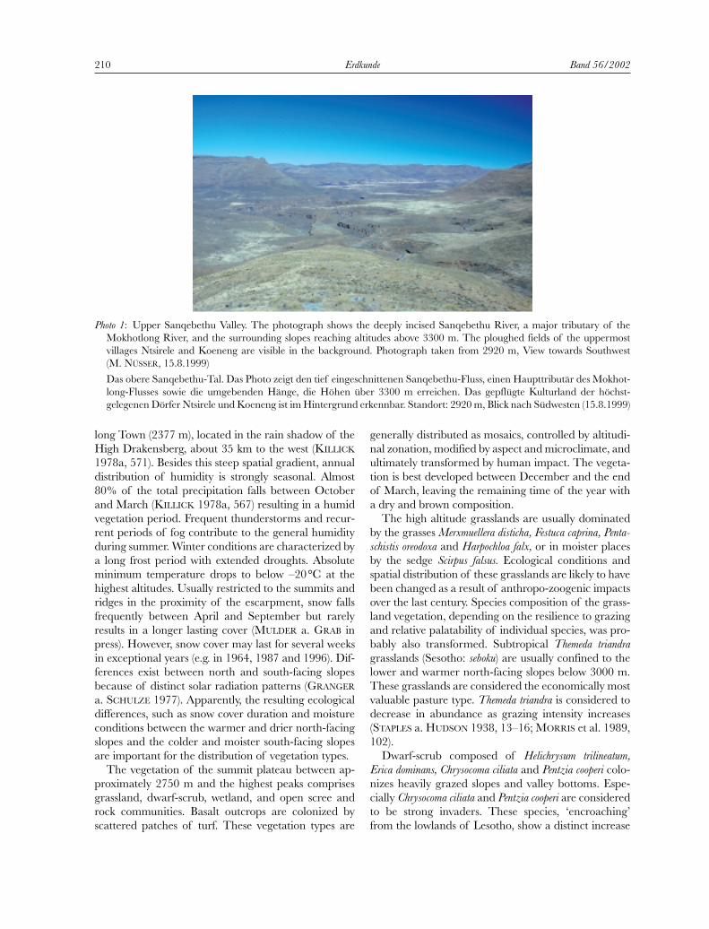
210 Erdkunde Band 56/2002
Photo 1: Upper Sanqebethu Valley. The photograph shows the deeply incised Sanqebethu River, a major tributary of theMokhotlong River, and the surrounding slopes reaching altitudes above 3300 m. The ploughed fields of the uppermostvillages Ntsirele and Koeneng are visible in the background. Photograph taken from 2920 m, View towards Southwest (M. NÜSSER, 15.8.1999)
Das obere Sanqebethu-Tal. Das Photo zeigt den tief eingeschnittenen Sanqebethu-Fluss, einen Haupttributär des Mokhot-long-Flusses sowie die umgebenden Hänge, die Höhen über 3300 m erreichen. Das gepflügte Kulturland der höchst-gelegenen Dörfer Ntsirele und Koeneng ist im Hintergrund erkennbar. Standort: 2920 m, Blick nach Südwesten (15.8.1999)

in abundance with high grazing pressure (MORRIS et al.1993, 49). Dwarf-scrub communities occupy largeareas of eastern Lesotho. In this treeless environment,dwarf-scrubs constitute the only fuel wood supply forthe shepherds at their grazing posts.
Sharply delimited and densely grown wetlands (Sesotho: makhaobo) and marshy grasslands of the uppercatchments contrast vividly with the surrounding dry slopes. The wetlands6) are rich in species and are con-sidered important grazing grounds during the dry winter period. The low-growing wetland vegetationcontains various grasses (Agrostis lachnantha, A. subulifolia,Poa annua) and sedges (Scirpus falsus, S. ficinioides, Isolepisfluitans and Schoenoxiphium filiforme) in variable quantities.Pools and silty depressions, often waterlogged in sum-mer, form habitats for aquatic plant communities, withhygrophilous forbs (Limosella inflata, Aponogeton ranunculi-florus, Crassula inanis, Ranunculus meyeri, Kniphofia caules-cens, Moraea alticola) and Trifolium burchellianum (VAN
ZINDEREN BAKKER 1955, 417; KILLICK 1978b, 539;
BACKÉUS a. GRAB 1995, 246). The wetland areas areoften fringed by Merxmuellera drakensbergensis patches atwater surplus sites. This less palatable tussock grass isfrequently burnt, to obtain fresh green sprouts, whichmake a better fodder, especially for cattle. Burning ofthe tussocks is also considered a method of repellingjackals, which may predate sheep and goats. Besides,the foliage of M. drakensbergensis is also used for that-ching of the grazing posts’ roofs and for making ropes.
3 Transhumance patterns in eastern Lesotho:principles and evolution
Land use strategies of the Basotho people combinecropping and animal husbandry. Regular seasonaltranshumance patterns between villages and mountainpastures are an integral element of the mixed agricul-tural system. Large flocks of sheep, goats, cattle andhorses are kept in the high altitude grasslands duringthe summer grazing season between November andApril. Scattered grazing posts (Sesotho: motebo)7), withround stone huts and surrounding kraals, serve to housethe shepherds and their small stock overnight (Photo 2).
Marcus Nüsser: Pastoral utilization and land cover change: a case study from the Sanquebethu Valley, eastern Lesotho 211
Photo 2: Typical grazing post (motebo) with small livestock in the upper Sanqebethu Valley. High pasturing is organized byindividual shepherds, mostly young men, who live in the stone huts for extended periods. The roofs of these grazing postsare generally thatched with the foliage of the large tussock grass Merxmuellera drakensbergensis. Daily trailing of sheep and goats to and from this permanently used grazing post has led to accelerated soil erosion in close proximity to the motebo.Photograph taken from 2650 m (M. NÜSSER, 10.4.1999)
Typischer Weideposten (motebo) mit Kleintieren im oberen Sanqebethu-Tal. Die Hochweidenutzung wird von einzelnenHirten, zumeist Jugendlichen organisiert, die über längere Zeiträume in den Hütten leben. Die Dächer dieser Weidepostenwerden generell mit dem Tussock-Gras Merxmuellera drakensbergensis gedeckt. In unmittelbarer Umgebung dieses ganzjähriggenutzten Weidepostens zeigt sich verstärkte Bodenerosion infolge des täglichen Auf- und Abtriebs der Schaf- und Ziegen-herden. Standort: 2650 m (10.4.1999)
6) Hydrological functions, ecological aspects and degrada-tion of Lesotho’s wetlands, which act as sponges and secureperennial runoff, have been a major research issue over deca-des, e.g. VAN ZINDEREN BAKKER (1955); JACOT GUILLARMOD
(1962; 1963; 1969); VAN ZINDEREN BAKKER a. WERGER
(1974); GROBBELAAR a. STEGMANN (1987); HILLIARD a.BURTT (1987); BACKÉUS (1989); MEAKINS a. DUCKETT
(1993); BACKÉUS a. GRAB (1995); MORRIS a. GRAB (1997);GRAB a. MORRIS (1999); SELBACH (2001).
7) These grazing posts are mostly referred to as cattle postsin the literature but because of the large numbers of smallstock (sheep and goats) kept in the summer grazing areas theterm grazing post is preferred here.

The livestock grazes on the slopes in the vicinity ofthese motebos.
Summer grazing posts are usually located at altitudesbetween approximately 2750 and 3100 m. Althoughthe high altitude grasslands are predominantly used forsummer grazing, selected portions of these areas alsoserve as winter pastures, mainly for robust sheep andhorses (STAPLES a. HUDSON 1938, 19; QUINLAN 1995,503). In order to provide shelter in case of heavy snow-fall, most winter grazing posts are located near to theuppermost villages, regularly below 2750 m so that live-stock can be brought down quickly (QUINLAN a. MOR-RIS 1994, 78). As considerable portions of the subtropi-cal Themeda triandra grasslands, especially on the moregentle slopes, have been transformed into cultivatedfields and degradation of the remaining winter pastu-res in the village environs is widespread, stockholdersare forced to use the high altitude grasslands on a per-manent basis. Lack of sufficient winter forage is consi-dered the major constraint for livestock keeping in theLesotho highlands (Photo 3). Besides frequent animallosses due to deficient fodder resources, heavy snowfalland extended periods of drought, livestock keeping isconfronted with high levels of stock theft and predatoryjackals.
The altitudinal zonation and seasonal pattern oflivestock keeping have evolved over the last century inresponse to increasing degradation of the lowlands andfoothills (QUINLAN 1995, 492; NÜSSER 2001, 33). Rapidexpansion of cultivated areas with scattered villages up
to about 2700 m commenced simultaneously since the1890s (STAPLES a. HUDSON 1938, 19). The develop-ment of land use evolved in parallel with distinct terri-torial utilization rights. Grazing areas in the vicinity ofthe villages were controlled by local chiefs and head-men, who imposed basic regulations to prevent freegrazing of animals during the cropping season. Certainareas containing useful vegetation were set aside for thepropagation of grass, thatch grass, and fuel wood. Theneed to conserve pastoral resources and livestock is based in indigenous law through the concept of leboella,which basically refers to restrictions of utilization in order to promote regeneration of natural vegetationand rotational usage (QUINLAN 1989, 25; WITZSCH
1992, 23). In contrast, temporal and spatial restrictionsof utilization are rather limited and difficult to controlin the remote mountain pastures. Grazing rights for thehigh altitude grassland have solely been issued by thePrincipal Chiefs as traditional leaders of the Basothopeople, who had no reason to restrict pastoral utiliza-tion in these uninhabited areas. The lack of conceivedterritoriality over the mountain pastures has given riseto a transhumance system, which is based upon clanand kinship relations. Therefore, stockholders from different mountain villages and from the lowlands ofLesotho use the high pastures in common. Livestockownership is further complicated by the traditionalsystem of animal loans (Sesotho: mafisa), which is basedon arrangements between stock owners and hired shepherds who care for the animals. Because of these
212 Erdkunde Band 56/2002
Photo 3: The Koeneng Village (2530 m) forms the uppermost permanent settlement accessible for four-wheel drive vehicles inthe Sanqebethu Valley. During wintertime the cultivated fields and the village environs are used as pastures. View towardsWest (M. NÜSSER, 13.8.1999)
Das Dorf Koeneng (2530 m) bildet die höchstgelegene, über eine Piste erschlossene Dauersiedlung im Sanqebethu-Tal.Während des Winters wird das Kulturland und die Dorfumgebung als Weidefläche genutzt. Blick nach Westen (13.8.1999)

flexible arrangements, people can send their animals to the high pastures, even if their households have notsufficient workforce to cope with the demands ofmobile livestock keeping.8)
The evolution of resource utilization and of the pre-valent transhumance pattern is also marked by externalinterventions and innovations, which began during British colonial times. Prominent examples encompassanti-erosion schemes (SHOWERS 1989, 264; 1996, 655),the promotion of rotational grazing systems and de-stocking campaigns (PIM 1935, 140–143; STAPLES a.HUDSON 1938, 39–40). Traditionally, the Basotho live-stock economy mainly concentrates on cattle breeding.Merino sheep and angora goats for wool and mohairproduction were introduced during colonial projects in the early 1900s, with a view of encouraging market-orientated livestock rearing (QUINLAN 1995, 493). Theintroduction of horses and donkeys as riding and packanimals, and selective breeding of the robust Basothopony were necessary innovations to cope with increas-ing transport demands after the construction of bridlepaths.
Post-colonial developments in pastoral resource utili-zation are strongly influenced by regulating interven-tions implemented by the state of Lesotho. Ongoingconflicts between the traditional leaders within thesystem of Chieftainship and elected DevelopmentCouncils (since 1986) have led to unsolved problems ofcompetence in adjudication of grazing rights (NÜSSER
2001, 34). Supported by international aid organiza-tions, a number of development projects, which focuson livestock rearing and sustainable resource utilizationhave been established during the past 20 years. The objectives comprise a termination of seasonal trans-humance between lowlands and mountains, inventoriesof grazing areas, livestock registration and grazing fees(MARTIN 1984, 32; PHORORO a. SIBOLLA 1999, 73).The intention was to replace the extensive subsistenceeconomy with a commercial community-managed andstate-regulated economy. The most substantial strategyto achieve these goals has been the introduction ofRange Management Areas (RMA) for exclusive utiliza-tion rights of registered members of Grazing Associa-tions (WEAVER 1991; ARTZ 1993; BUZZARD 1994).
Since 1988, the Sanqebethu Valley has been part ofthe Mokhotlong/Sanqebethu RMA and the Grazing
Association was registered in 1991. To the present daythe RMA programme is largely rejected by the Basothoand the Grazing Association is reported to have lackedthe support of most chiefs from the beginning (HART-LEY 2001, 39). Recent efforts in environmental conser-vation concentrate on the implementation of a ‘Trans-frontier Conservation Area’. This area is designed toencompass the eastern Lesotho highlands together withthe protected areas in the South African uKhahlamba Drakensberg Park, administered by the KwaZulu/Natal Nature Conservation Service. This area has recently (2000) been proclaimed a World Heritage Site.
4 Contemporary land use and land cover change in the Sanqebethu Valley
4.1 Development of pastoral utilization
Animal numbers and corresponding livestock units(Tab. 1), resulting stocking densities (Tab. 2), and thenumbers of grazing posts (Tab. 3) are used as indicatorsto quantify recent development of pastoral utilizationin the Jareteng, Langa-le-balele and Merareng Valleys.Although the grazing posts are also mapped in theMahlabachana, Moiteling and upper Mokhotlong Val-leys (Fig. 2 – Suppl. III), comparative analyses are notpossible in these areas due to the lack of quantitativedata from the late 1980s.
Moreover, seasonal differences and spatial aspects ofgrazing post utilization have to be taken into conside-ration, as these factors contribute significantly to un-even grazing intensity. In sheltered positions, especiallyin the vicinity of junctions with the tributaries of theSanqebethu River one can find a number of grazingposts that are used throughout the year. These perma-nently used grazing posts are located below 2750 m, sothat the uppermost villages can be reached within threeto four hours in case of snow hazards. On the otherhand, the harsh climatic conditions in the immediateproximity of the escarpment form a major constraintfor utilization. Therefore, the density of grazing posts islower and the number of abandoned and desertedstock outposts is higher in the uppermost tributariesthan in the lower lying valley sections (Fig. 2 – Suppl. III).Abandonment of grazing posts can result for multiplereasons. These reasons comprise inter-annual varia-tions in utilization due to changes in mafisa arrange-ments, insufficient pasture and fuel wood resources,and the extent of burning and the resulting lack of tus-sock grasses necessary for roof thatching of the motebos.
The figures from 1988 and 1999 show a remarkableand in some cases an extreme decrease in the intensity
Marcus Nüsser: Pastoral utilization and land cover change: a case study from the Sanquebethu Valley, eastern Lesotho 213
8) Widespread pooling of herds and delegation of livestockgrazing activities appear to be consequences of Lesotho’s traditional labour migration system, characterized by the absence of male workforce, who take non-agrarian incomeopportunities in South Africa, mainly in the gold mines.

of high pasture utilization. The decrease in livestockunits and resulting stocking densities is more pronoun-ced in the Jareteng and Langa-le-balele Valleys and inthe case of sheep and goats in both summer and wintergrazing areas. Only the pastures of the Merareng Val-ley, situated in close proximity to the uppermost per-manent settlements, show a slight increase in the inten-sity of utilization, especially in the case of wintergrazing. These results are supported by the numbersand seasonal utilization of motebos (Fig. 2 – Suppl. III).Whereas the totals of summer grazing posts havedecreased in all valleys between 1988 and 1999, thenumbers of permanently used grazing posts do notvary to any great extent (Tab. 3). Only the figures fromthe Merareng Valley show a slight increase in perma-nent grazing posts. Interviews with the shepherds in theJareteng and Langa-le-balele Valleys revealed that theintensity of winter use decreased in these upper trib-
utaries after the snow disaster occurring in 1996. Thishazardous event resulted in a snow cover, which lastedfor more than three months on the summits of theDrakensberg escarpment.
4.2 Land cover change
In order to correlate the results of the comparativeanalyses of pastoral utilization intensity with corre-sponding land cover change, multi-temporal satellitedata (Landsat 5 TM imagery, 169/80) from the end ofthe vegetation period in March 1989 and March 1999were assumed to be a suitable data source for changedetection.9) Both images (9.3.1989 and 5.3.1999) showsimilar atmospheric conditions. Precipitation data fromUnderberg (Station Shaleburn, 1613 m, 29°48’ S,29°21’E) in South Africa, situated c. 60 km to the southof Sanqebethu Valley at the foot of the escarpment, in-
214 Erdkunde Band 56/2002
Table 1: Animal numbers and livestock units (LU) in the upper tributaries of the Sanqebethu Valley, 1988 and 1999Tierzahlen und Tiereinheiten (LU) in den oberen Tributären des Sanqebethu-Tales, 1988 und 1999
Tributary valley / grazing area Sheep Goats Cattle Horses Donkeys Totals
Season 1988 1999 1988 1999 1988 1999 1988 1999 1988 1999 1988 1999JaretengAnimal numbers summer 2530 1256 1419 722 291 157 91 91 27 32
winter 770 180 66 88 0 71 6 5 0 0Livestock units summer 506.0 251.2 283.8 144.4 232.8 125.6 63.7 63.7 13.5 16.0 1099.8 600.9
winter 154.0 36.0 13.2 17.6 0 56.8 4.2 3.5 0 0 171.4 113.9Langa-le-baleleAnimal numbers summer 1037 999 879 467 198 116 49 20 21 21
winter 133 0 0 0 0 0 0 0 0 0Livestock units summer 207.4 199.8 175.8 93.4 158.4 92.8 34.3 14.0 10.5 10.5 586.4 410.5
Winter 26.6 0 0 0 0 0 0 0 0 0 26.6 0MerarengAnimal numbers summer 1401 1597 903 622 132 79 56 72 16 33
winter 691 721 23 115 0 26 9 21 0 19Livestock units summer 280.2 319.4 180.6 124.4 105.6 63.2 39.2 50.4 8.0 16.5 613.6 573.9
winter 138.2 144.2 4.6 23.0 0 20.8 6.3 14.7 0 9.5 149.1 212.2
Animal unit conversion according to Range Management Division (1990): sheep: 0.2, goat: 0.2, cattle: 0.8, horse: 0.7, donkey: 0.5Data for 1988: QUINLAN (1989); QUINLAN a. MORRIS (1994); data for 1999: author’s own surveys and calculations
Table 2: Stocking densities (SD) in the upper tributaries of the Sanqebethu Valley, 1988 and 1999Bestockungsdichten (SD) in den oberen Tributären des Sanqebethu-Tales, 1988 und 1999
Jareteng Langa-le-balele Merareng Total
Tributary valley/grazing area [ha] 2306 1321 2387 6014Stocking densities [LU/ha]Summer 1988 0.48 0.44 0.26 0.38Summer 1999 0.26 0.31 0.24 0.26Winter 1988 0.07 0.02 0.06 0.06Winter 1999 0.05 0 0.09 0.05
Data for 1988: QUINLAN (1989); QUINLAN a. MORRIS (1994); data for 1999: author’s own surveys and calculations

dicate that the vegetation period 1988/89 receivedconsiderably higher amounts of precipitation than therespective period 1998/99 (October 1988 – March1989: 939.6 mm; October 1998 – March 1999: 787.2mm).10) Varying humidity during the two growing sea-sons may result in phenological differences, but visualinterpretation shows slight variation only.
The differences between the satellite images fromMarch 1989 and 1999 become more obvious, after cal-culating Normalized Difference Vegetation Indices (NDVI).11)
A certain decrease in vegetation cover and correspon-ding pasture phytomass can be detected, especially inplaces of grazing post concentrations and more acces-sible areas, e.g. in the Sanqebethu Valley and in the lower portions of the Jareteng and Langa-le-balele Valleys. On the other hand, the large wetlands in the remote upper sections of the Merareng and Mokhot-long Valleys do not show detectable changes (Fig. 4).
The results from interpretation of remote sensingdata are supported by recent field surveys and vegeta-tion transects.12) According to these data, the slopes ofthe Sanqebethu Valley between approximately 2700
and 2980 m reveal poor range conditions with highproportions of Chrysocoma ciliata and Pentzia cooperi. Theopen grasslands between basalt outcrops are generallycharacterized by heavy grazing with high intensity ofwinter grazing and single stands of burnt Merxmuelleradrakensbergensis patches. Also the predominantly north-facing transects from the Jareteng and Langa-le-baleleValleys (2750–3150 m) show poor to fair range con-ditions. Obviously these areas are heavily grazed, espe-cially in the vicinity of grazing post concentrations nearthe river junctions.
Poor range conditions, discernible erosion and turfloss in the lower valley sections must be regarded asconsequences of permanent grazing pressure through-out the year. In contrast, in some of the higher tributa-ries range conditions are more positive (Photo 4). Theharsh climatic conditions in these upper valley headspresent a major constraint to herders and livestock andthe grasslands in close proximity of the escarpment canbe described as ‘additional’ summer pastures. Thesame holds true for the above mentioned wetlands inthe upper sections of the Merareng and MokhotlongValleys.
5 Discussion and conclusions
The study area is part of a mountain environmentthat has been transformed by pastoral utilization dur-ing the past century. Research findings from the late1980s (QUINLAN 1989, 67; MORRIS et al. 1989, 84–85)show an exponential increase in grazing post numbersbetween the 1930s and the late 1980s. The rapid expansion of pastoral utilization in the upper ecologi-cal belt is further reinforced by the tendency to extendthe grazing period in the high altitude grasslands due todegradation of winter pastures in the village environs(QUINLAN a. MORRIS 1994, 78; QUINLAN 1995, 503).Apparently, these findings correspond to the typicaldevelopmental scenario for Lesotho. However, the assessment of recent land use change between 1988and 1999 presented here provides evidence for a con-
Marcus Nüsser: Pastoral utilization and land cover change: a case study from the Sanquebethu Valley, eastern Lesotho 215
Table 3: Number of grazing posts and intensity of utilizationAnzahl und Nutzungsintensität der Weideposten
Jareteng Langa-le-balele Merareng
Year 1988 1999 1988 1999 1988 1999utilization during summer 20 14 14 10 7 5utilization permanently 6 4 1 1 5 6abandoned, deserted 3 13 no data 11 no data 7
Data for 1988: QUINLAN (1989); QUINLAN a. MORRIS (1994); data for 1999: author’s own surveys and calculations
9) Standardized operations of digital image processinghave been carried out to obtain a database for comparative visual and digital interpretation.
10) These data were kindly provided by S. Grab (Universityof the Witwatersrand, Johannesburg). Corresponding rainfalldata from the study area are not available.
11) Landsat TM bands 4 (Near Infrared, NIR) and 3 (Red)of corresponding subsets have been used to calculate thisstandard vegetation index according to the algorithm NDVI =(NIR-Red)/(NIR+Red). This transformation of multispectraldata into a single image band indicates the amount of greenphytomass present in each pixel and represents vegetationdistribution.
12) The vegetation transects were carried out using the metric belt transect method, which is used to determine cover, species composition, relative species abundance andphytomass production. This method uses a double-samplingtechnique to convert crown cover measurements for the species to total standing phytomass by species and, thereafter,for the transect (SCHMUTZ et al. 1982; MORRIS et al. 1989).

trasting trend, characterized by a conspicuous decreasein the intensity of high pasture utilization. As annualdata of utilization intensity and continuous time seriesof animal numbers are not available, interpretation ofchange over the interim decade is based on the two
years of observation only. The explanation of contem-porary land use and land cover change between the late1980s and the late 1990s needs to incorporate multi-factorial causes. These principal components of pasto-ral development include climatic impacts such as rain-
216 Erdkunde Band 56/2002
9.3.1989
NNN
Giant's CastleGiant's CastleGiant's Castle
3314 m3314 m3314 m
0 1 2 3 4 5 km
NN
Giant's CastleGiant's Castle
3314 m3314 m
NN
Giant's CastleGiant's Castle
3314 m3314 m
0 1 2 3 4 5 km
5.3.1999
NNN
Giant's CastleGiant's CastleGiant's Castle
3314 m3314 m3314 m
Fig.3: Geo-referenced subsets of Landsat TM imagery (169/80) showing the upper Sanqebethu Valley, colour composites,4,3,2 = RGB, (a) 9.3.1989 and (b) 5.3.1999
Georeferenzierte Ausschnitte von Landsat TM-Bildern (169/80) des oberen Sanqebethu-Tales, Farbkompositen, 4,3,2 =RGB, (a) 9.3.1989 und (b) 5.3.1999
a)
b)

fall variability and natural hazards, exogenous factorssuch as market-orientated incentives and constraints,and responding changes in livelihood strategies (Fig. 5).
Apparently, inter-annual rainfall variability and natural hazards cause significant modifications in the
intensity of pastoral utilization. However, the markeddecrease in pastoral utilization between 1988 and 1999cannot be satisfactorily explained as a consequence oflivestock losses after the snowfall during July 1996, be-cause the data for 1988 also reflect the preceding snow
Marcus Nüsser: Pastoral utilization and land cover change: a case study from the Sanquebethu Valley, eastern Lesotho 217
NN
Giant's CastleGiant's Castle
3314 m3314 m
-1-1 00 11
0 1 2 3 4 5 km
9.3.1989
NNN
Giant's CastleGiant's CastleGiant's Castle
3314 m3314 m3314 m
-1-1-1 000 111
5.3.1999
NNN
Giant's CastleGiant's CastleGiant's Castle
3314 m3314 m3314 m
-1-1-1 000 111
0 1 2 3 4 5 km
NN
Giant's CastleGiant's Castle
3314 m3314 m
-1-1 00 11
Fig.4: NDVI calculations of geo-referenced Landsat TM imagery showing the upper Sanqebethu Valley, (a) 9.3.1989 and (b) 5.3.1999
Aus den georeferenzierten Landsat-Daten berechnete Vegetationsindices (NDVI) des oberen Sanqebethu-Tales, (a) 9.3.1989und (b) 5.3.1999
a)
b)

hazard from late September 1987. The recent decreasein small stock populations can only be explained byexogenous factors such as falling prices and unpopularmarketing arrangements for wool and mohair (PHO-RORO a. SIBOLLA 1999, 62).
Despite the significant reduction in high pasture uti-lization, the comparative analysis of satellite imageryreveals a slight decrease in vegetation cover of the highaltitude grasslands over the interim decade. It remainsuncertain to what extent land cover change results fromcontinuous (although reduced) grazing pressure orfrom differences in precipitation between 1989 and1999. However, the detectable pattern of grassland degradation in the vicinity of permanent grazing postsindicates continued over-use throughout the year.Evidently, the high intensity of winter and early springgrazing primarily accounts for the observed degrada-tion of pastures in the lower valley sections.
The high altitude grasslands of Lesotho are manag-ed under a common property regime and the grazingsystem follows a utilization strategy, which is typical fornon-equilibrium environments. As the livestock eco-nomy is prone to natural hazards and high levels ofrainfall variability, mobility and flexibility are conside-red key components of regional livelihood strategiesunder the prevailing conditions of uncertainty.
Grazing issues in Lesotho are typically presented as a ‘tragedy of the commons’ scenario together withconventional policy solutions of increased state controlover the pastoral resources or privatization of range-lands (MAJORO 1999, 15). The most substantial Gov-ernment intervention to address grazing issues has been
the introduction of the Range Management Areas Pro-gramme. As this programme questions the legitimacyof the traditional transhumance pattern and proposesreductions in stock numbers aligned to ecologicalcarrying capacities, it has largely been rejected by thelocal Basotho population. Without recognizing theprinciples, necessities, shortcomings and possible alter-natives of the current transhumance pattern, any effortto reduce animal numbers in the high altitude grass-lands will definitely lead to overstocking and further degradation of lower lying winter pastures in the vicinity of the permanent settlements. A participatoryapproach and a recognition of existing rules and regu-lations in the management of common property regimes are essential requirements for effective planningof pastoral resource management. Recent concepts onmanaging common pool resources (e.g. OSTROM 1990;HANNA et al. 1995; BERKES a. FOLKE 1998) strengthenthe idea that the existing institutions within naturalresource management systems may provide a moreappropriate basis to develop a functioning commons.Whether or not the continual dilemma between thetraditional grazing system and the prevailing environ-mental degradation in Lesotho can be resolved byexternal interventions remains an open question.
Acknowledgements
This study was generously supported by the VW-Foundation (Volkswagen-Stiftung) and by the GermanResearch Council (Deutsche Forschungsgemeinschaft).
218 Erdkunde Band 56/2002
Photo 4: Positive range conditions can be found in remote areas of the higher tributaries in close proximity to the escarpment,Mohlesi Valley, 2940 m, view towards Southeast (M. NÜSSER, 16.4.1999)
In abgelegenen Bereichen der oberen Tributäre, insbesondere am Rand des Escarpments lassen sich günstige Weide-bedingungen erkennen. Beispiel aus dem Mohlesi-Tal, 2940 m. Blick nach Südwesten (16.4.1999)

Marcus Nüsser: Pastoral utilization and land cover change: a case study from the Sanquebethu Valley, eastern Lesotho 219
Wetlands
Land use and land cover change
Land use pattern
High altitude grasslands
Tussock grasses
win
ter grazin
g areas
Su
mm
er grazin
g areas
Villagewith cultivated fields
Grazing post (motebo)intensity of utilization(summer/winter/permanently/deserted)
Seasonal pastoral migration
Grazing(summer/winter)
Climatic variabilityNatural hazards
Rules and regulationsMarket conditions
Grassland degradation,turf loss
Altitu
din
al zon
ation
of n
atural reso
urces:
po
tentials an
d lim
itation
s
Draft: M. Nüsser
Non-equilibriumdynamic patterns
Livelihood and rangemanagement strategies
External influencesand interventions
Common propertyregime
Intensity of pastoral utilizationchanges and variation
Incentives andconstraints
Conditions ofuncertainty Mobility and
flexibility
Altitude [m]
2300
2400
2500
2900
3300
3000
3400
3200
3100
2600
2700
2800
S
S S
S
S
W
W W
S
S
S
S
SW
PP
D
D
D
P D
Fig.5: Principal components of pastoral resource utilization patterns and impact factors of corresponding land cover changein eastern Lesotho
Hauptkomponenten der weidewirtschaftlichen Ressourcennutzungsmuster und Einflussfaktoren auf den Landschafts-wandel im östlichen Lesotho

The author is much indebted to Dr. S. Grab (Johan-nesburg), Dr. D. Hartley and Dr. E. Pohl (formerly Ma-seru) for helpful discussions and co-operation, to Dr. O.M. Hilliard and B. L. Burtt (Edinburgh) for identificati-ons of the plant collections, and to S. Ramatla and M.Mohlomi (Maseru) for kindly providing assistance during fieldwork. The support by the Ministry of Agri-culture’s Range Management Division, especially byM. Maseka, M. Masila and N. Suhla (Maseru) and bythe National Environment Secretariat of Lesotho isgratefully acknowledged. Helpful comments from tworeviewers are greatly appreciated.
References
ARTZ, N. E. (1993): Local participation, equity, and popularsupport in Lesotho’s range management area programme.In: African Journal of Range and Forage Science 10,54–62.
BACKÉUS, I. (1989): Flarks in the Maloti, Lesotho. In: Geo-grafisker Annaler 71(A): 105–111.
BACKÉUS, I. a. GRAB, S. W. (1995): Mires in Lesotho. In:Gunneria 70, 243–250.
BAINBRIDGE, W. R.; MOTSAMAI, B. a. WEAVER, L. C. (1991):Report of the Drakensberg/Maluti conservation pro-gramme. Pietermaritzburg.
BEHNKE, R. H. a. ABEL, N. (1996): Revisited: the overstockingcontroversy in semi-arid Africa. In: World Animal Review87, 4–27.
BEHNKE, R. H. a. SCOONES, I. (1993): Rethinking range eco-logy: implications for rangeland management in Africa. In:BEHNKE, R. H., SCOONES, I. a. KERVEN, C. (Eds.): Rangeecology at disequilibrium. New models of natural variabi-lity and pastoral adaptation in African savannas. London,1–30.
BERKES, F. a. FOLKE, C. (1998): Linking social and ecologicalsystems for resilience and sustainability. In: BERKES, F. a.FOLKE, C. (Eds.): Linking social and ecological systems:management practices and social mechanisms for buildingresilience. Cambridge, 1–25.
BUZZARD, R.F. (1994): Assessing the sustainability of grazingassociations in Lesotho. In: HATCH, G. P. a. ZACHARIAS,P. J. K. (Eds.): Second developing areas symposium pro-ceedings: people, rangelands and development. GrasslandSociety of Southern Africa. Pietermaritzburg, 13–19.
CHAKELA, Q. K. (1999): Environmental trends and scenarios.In: CHAKELA, Q. K. (Ed.): State of the environment in Lesotho 1997. Maseru, 205–211.
EHLERS, E. (2000): Globale Umweltforschung und Geogra-phie – ein “State of the art”-Bericht. In: Petermanns Geo-graphische Mitteilungen 144, 58–65.
GAY, J.; GILL, D. a. HALL, D. (1995): Lesotho’s long journey:hard choices at the crossroads. Maseru.
GEIST, H. (1999): Exploring the entry points for political ecology in the international research agenda on global
environmental change. In: Zeitschrift für Wirtschaftsgeo-graphie 43, 158–168.
GRAB, S. W. a. MORRIS, C. (1999): Soil and water resource issues of the eastern alpine belt wetlands in Lesotho. In:HURNI, H. a. RAMAMONJISOA, J. (Eds.): African mountaindevelopment in a changing world. Antananarivo (Mada-gascar), 207–219.
GRAB, S. W. a. NÜSSER, M. (2001): Towards an integrated research approach for the Drakensberg and Lesotho mountain environments: a case study from the Sani plateau region. In: South African Geographical Journal83, 64–68.
GRANGER, J. E. a. SCHULZE, R. E. (1977): Incoming solar radiation patterns and vegetation response: examples fromthe Natal Drakensberg. In: Vegetatio 35, 47–54.
GROBBELAAR, J. U. a. STEGMANN, P. (1987): Limnological characteristics, water quality and conservation measures ofa high altitude bog and rivers in the Maluti mountains,Lesotho. In: Water South Africa 13, 151–158.
HANNA, S.; FOLKE, C. a. MÄLER, K. G. (1995): Propertyrights and environmental resources. In: HANNA, S. a.MUNASINGHE, M. (Eds.): Property rights and the environ-ment. Washington, 15–28.
HARDIN, G. (1968): The tragedy of the commons. In: Science162, 1243–1248.
HARTLEY, D. (2001): Synthesis report on preparing inte-grated natural resource management. Drakensberg/Maloti mountains conservation programme. Maseru.
HILLIARD, O. M. a. BURTT, B. L. (1987): The botany ofthe southern Drakensberg. Annals of the Kirstenbosch Botanic Gardens 15. Cape Town.
JACOT GUILLARMOD, A. (1962): The bogs and sponges of theBasutoland mountains. In: South African Journal ofScience 58, 179–182.
– (1963): Further observations on the bogs of the Basutolandmountains. In: South African Journal of Science 59,115–118.
– (1969): The effect of land usage on aquatic and semi-aquatic vegetation at high altitudes in southern Africa. In:Hydrobiologia 34, 3–13.
KILLICK, D. J. B. (1963): An account of the plant ecology ofthe Cathedral Peak area of the Natal Drakensberg.Memoirs of the Botanical Survey of South Africa 34.Pretoria.
– (1978a): Further data on the climate of the alpine vegeta-tion belt of eastern Lesotho. In: Bothalia 12, 567–572.
– (1978b): The afro-alpine region. In: WERGER, M. J. A.(Ed.): Biogeography and ecology of southern Africa.Monographiae Biologicae 31. The Hague, 515–560.
LAMBIN, E. F.; BAULIES, X.; BOCKSTAEL, N.; FISCHER, G.;KRUG, T.; LEEMANS, R., MORAN, E. F.; RINDFUSS, R. R.;SATO, Y.; SKOLE, D.; TURNER, B. L. II a. VOGEL, C. (1999):Land-use and land-cover change: implementation strategy(LUCC). IGBP Report 48 and IHDP Report 10, Stockholmand Bonn.
LEACH, M. a. MEARNS, R. (1996): Challenging received wisdom in Africa. In: LEACH, M. a. MEARNS, R. (Eds.):The lie of the land. Challenging received wisdom on theAfrican environment. London, 1–33.
220 Erdkunde Band 56/2002

MAFAKANE, M. (1999): Roads. In: CHAKELA, Q. K. (Ed.):State of the environment in Lesotho 1997. Maseru,97–104.
MAJORO, M. (1999): Environment and economic develop-ment. In: CHAKELA, Q. K. (Ed.): State of the environmentin Lesotho 1997. Maseru, 1–18.
MARTIN, N. L. (1984): A national range inventory for theKingdom of Lesotho. In: Journal of the Grassland Societyof South Africa 1, 29–32.
MEAKINS, R. H. a. DUCKETT, J. D. (1993): Vanishing bogs ofthe mountain kingdom. In: Veld and Flora 79, 49–51.
MORRIS, C. D.; BOLEME S. a. TAINTON, N. M. (1989): Reporton investigations into the fire and grazing regimes and the conservation needs of the eastern alpine catchments of Lesotho. Drakensberg/Maluti Mountain Catchment Conservation Programme: Fire and grazing project.Pietermaritzburg.
MORRIS, C. D. a. GRAB, S. W. (1997): A threatened resource:Lesotho’s alpine wetlands, unique in many ways, are facinga complexity of threats. In: African Wildlife 51 (3), 14–16.
MORRIS, C. D.; TAINTON, N. M. a. BOLEME, S. (1993): Clas-sification of the eastern alpine vegetation of Lesotho. In:African Journal of Range and Forage Science 10, 47–53.
MULDER, N. a. GRAB, S. W. (in press): Remote sensing forsnow cover analysis along the Drakensberg Escarpment:some palaeoenvironmental implications. In: South AfricanJournal of Science.
NIAMIR-FULLER, M. (1999): Toward a synthesis of guidelinesfor legitimizing transhumance. In: NIAMIR-FULLER, M.(Ed.): Managing mobility in African rangelands. Thelegitimization of transhumance. London, 266–290.
NÜSSER, M. (2000): Weidewirtschaft im östlichen Hochlandvon Lesotho – konzeptionelle Überlegungen zu einerhumanökologischen Studie der Ressourcennutzung. In:BÄHR, J. u. JÜRGENS, U. (Eds.): Transformationsprozesseim Südlichen Afrika – Konsequenzen für Gesellschaft undNatur. Kieler Geographische Schriften 104, 143–154.
– (2001): Ressourcennutzung und externe Eingriffe im peri-pheren Gebirgsland Lesotho. In: Geographische Rund-schau 53 (12), 30–36.
OSTROM, E. (1990): Governing the commons. The evolutionof institutions for collective action. Cambridge.
PERRIER, G. (1995): New directions in range managementplanning in Africa. In: SCOONES, I. (Ed.): Living with uncertainty. New directions in pastoral development in Africa. London, 47–57.
PHORORO, R. a. SIBOLLA, B. G. (1999): Rangeland and live-stock. In: CHAKELA, Q. K. (Ed.): State of the environmentin Lesotho 1997. Maseru, 57–75.
PIM, A.W. (1935): Financial and economic position of Basuto-land. London.
QUINLAN, T. (1989): The livestock economy in the mountainzone of Lesotho. Drakensberg/Maluti mountain catch-ment conservation programme: Socio-economic project.Pietermaritzburg.
– (1995): Grassland degradation and livestock rearing in Lesotho In: Journal of Southern African Studies 21,491–507.
QUINLAN, T. a. MORRIS, C. D. (1994): Implications of chan-ges to the transhumance system for conservation of themountain catchments in eastern Lesotho. In: African Jour-nal of Range and Forage Science 11, 76–81.
Range Management Division (1990): National livestock policy implementation plan. Maseru (unpubl.).
– (1991): Report on determination of carrying capacity andstocking rate for Mokhotlong/Sanqebethu in April–May1991. Maseru (unpubl.).
SANDFORD, S. (1995): Improving the efficiency of oppor-tunism: new directions for pastoral development. In:SCOONES, I. (Ed.): Living with uncertainty. New directionsin pastoral development in Africa. London, 174–182.
SCHMUTZ, E. M.; REESE, M. E.; FREEMAN, B. N. a. WEAVER,L. C. (1982): Metric belt transect system for measuring cover, composition and production of plants. In: Range-lands 4, 162–164.
SCOONES, I. (1995): New directions in pastoral developmentin Africa. In: SCOONES, I. (Ed.): Living with uncertainty.New directions in pastoral development in Africa. London,1–36.
– (1996): Politics, polemics and pasture in southern Africa.In: LEACH, M. a. MEARNS, R. (Eds.): The lie of the land.Challenging received wisdom on the African environment.London, 34–53.
SELBACH, V. (2001): Die Veränderungen der Wetlands imNordosten Lesothos – eine Untersuchung anhand einesmultitemporalen Luftbildvergleichs. Diplomarbeit Univer-sität Bonn (unpubl.).
SHOWERS, K. (1989): Soil erosion in the Kingdom of Leso-tho: origins and colonial response, 1830s–1950s. In: Jour-nal of Southern African Studies 15, 263–286.
– (1996): Soil erosion in the Kingdom of Lesotho and deve-lopment of historical environmental impact assessment.In: Ecological Applications 6, 653–664.
STAPLES, R. R. a. HUDSON, W. K. (1938): An ecological survey of the mountain area of Basutoland. Crown Agentsfor the Colonies, London.
TURNER II, B. L. (1997): The sustainability principle in globalagendas: implications for understanding land-use/land-cover change. In: The Geographical Journal 163, 133–140.
TURNER II, B. L.; MEYER, W. B. a. SKOLE, D. L. (1994):Global land-use/land-cover change: towards an integratedstudy. In: Ambio 23, 91–95.
VAN ZINDEREN BAKKER, E. M. (1955): A preliminary surveyof the peat bogs of the alpine belt of northern Basutoland.In: Acta Geographica 14, 413–422.
VAN ZINDEREN BAKKER, E. M. a. WERGER, M. J. (1974):Environment, vegetation and phytogeography of the high-altitude bogs of Lesotho. In: Vegetatio 29, 37–49.
WEAVER, L. C. (1991): Management of communal natural resources through community-based grazing associations.In: PORTILLO, E. M.; WEAVER, L. C. a. MOTSAMAI, B.(Eds.): Planning for management of communal natural resources affected by livestock. Maseru, 154–180.
WITZSCH, G. (1992): Lesotho environment and environmentlaw. Roma (Lesotho).
Marcus Nüsser: Pastoral utilization and land cover change: a case study from the Sanquebethu Valley, eastern Lesotho 221

2695
2995
3110
2715 3170
2620
3070
2665
2685
3210
3290
3190
Ha Motokene
Letlapeng
Ntloana-Tsoana
Leqheku
Roikate
Thaba-Chitja
Thaba-Ntso
Thaba-Putsoa
Ntsirele(Ha Taemane)
NkokameleHa Mokoekoe
(Ha Motlalepula)Tsieng
Koeneng
Ha Ralefatla
Fika-le-Motho
Thaba-Moea
MerarengBannerman’s Pass
Langa-le-balelePass
Mokhotlong
Roikate
Tsiu
Lekh
oab
a
Leutso
Seetsets
3000
Mak
oa
e
M
okhotlong
Khomo-Khoana
Nkoeng
Sanqebethu
Sanqebeth
u
Moiteling
Jareteng
Kha
m
’a-Qheku
Ntjanyana
2695
3000
3000
3000
3000
2800
2600
2400
2600
2800
3000
3000
2800
2600
2800
3200
3000
3200
3200
3000
3000
2800
3200
3200
3000
3200
3200
3000
2800
2800
2600
2600
2800
2800
2800
3000
3000
3000
30003000
2800
3000
3000
3200
2400
2800 2600
3200
2600
2400
2400
2800
3000
3200
3000
2800
2600
3200
2800
3145
3200
3200
29°20’E29°15’S29°15’E
Pat
i sen
g
Mphera
Merareng
3390
Kholong
Tsakhelo
Langa-le-balele
Mahlabachana
29°20’E
29°25’E
29°25’E
29°15’E
29°20’S29°20’S
29°15’S
Merareng
Jareteng
Mokhotlong
Moiteling
Langa-le-balele
Mahlabachana
Ntsanyana
Cultivated land
0 1 2 3 4 5 km
Sources: Lesotho 1:50 000, sheet 2929 AD (39):Thabana Ntlenyana, 1982; Landsat TM data (169/80), 5.3.1999; Field surveys by T. Quinlan 1988 and M. Nüsser 1999 Draft: M. Nüsser; Cartography: G. Bräuer-Jux, M. Nüsser
Wetland200 m
Contour lines
100 m50 m
Altitude [m]
Village
Track(four-wheel drive)
Internationalboundary
Grazing area
Grazing post (motebo), intensity of utilization
utilization during summer (1988 and 1999)
deserted (1999)
utilization permanently (1988 and 1999)
utilization permanently (1999)
utilization during summer (1999)
utilization during summer (1988, abandoned 1999)
not visited, status unknown
Beilage III zu ERDKUNDE 56,2 Beitrag NüsserFig. 2 Map of Sanqebethu Valley