partnerships: the key to success - noaa tides &...
TRANSCRIPT

CO-OPS is a center of expertise whose mission is the collection,
analysis, and dissemination of integrated oceanographic
information to protect life, property, and the environment.
Coastal Oceanographic Applications and Services of Tides
and Lakes (COASTAL)
Center for Operational Oceanographic Products and Services (CO-OPS)
Coastal Oceanographic Applications and Services of Tides And Lakes (COASTAL)
[email protected](301) 713-2890
COASTAL products and information are critical for a variety of applications, including habitat restoration, coastal engineering and decision making, emergency management, and long-term planning for sea level changes. COASTAL supports and has partnered with a broad range of organizations, including:
Government Federal State Local
Local Organizations Non-profit Environmental
Commercial Industry Engineers
Developers
Coastal Zone Managers Emergency Managers Decision-Makers
Science communities Restoration Scientists and Planners
Biologists and Ecologists
Physical Oceanographers
Partnerships: The Key to Success
Addressing the special challenges along our nation’s land – water interface demands multi-faceted solutions. In 2005, the COASTAL Programs within CO-OPS and NOAA’s National Geodetic Survey (NGS) formed a partnership to facilitate the dissemination of integrated water levels and tidal datums with heights and geodetic datums. The COASTAL partnership leverages the unique expertise, experience, and capabilities within CO-OPS and NGS. The CO-OPS team brings expertise in precise determination of water levels and tidal datums, while NGS contributes land elevation information and analysis and surveying expertise. Together this integrated program works with federal, state, and local partners to support development and implementation of critical ecosystem management and emergency response strategies. Successful COASTAL partnerships have been developed with several NOAA offices, as well as a number of state, and local agencies, academic and private institutions, and federal agencies including the U.S. Geological Survey, U.S. Army Corps of Engineers, U.S. Fish and Wildlife Service, and the National Park Service.
The COASTAL Program also provides training and technical guidance on utilizing accurate water level and elevation information for various applications. Tailored tools currently under development include a web-based frequency and duration of inundation analysis and a GIS application called Marsh Analysis and Planning Tool Integrating Tides and Elevation (MAPTITE), which is designed to estimate marsh grass planting zones based on the correlation between plant tolerances, elevation, and tidal information.
www.tidesandheights.noaa.gov
Coastal Oceanographic Applications and Services of Tides
and Lakes (COASTAL)
F or 200 years NOAA has maintained accurate information on water levels and tidal datums for use in navigation and shoreline boundary determination. Today, in light of growing aware-
ness for the vulnerability of coastal ecosystems to degrada-tion and coastal hazards, this information is being
applied in a myriad of new ways. The Coastal Ocean-ographic Applications and Services of Tides And
Lakes Program (COASTAL) of NOAA’s Center for Operational Oceanographic Products and
Services (CO-OPS) leverages precise water level information for coastal ecosystem
management applications that include coastal development and engineer-
ing, habitat restoration, long-term sea level assessments, storm surge
monitoring, tsunami warning support, emergency prepared-
ness, and HAZMAT response.
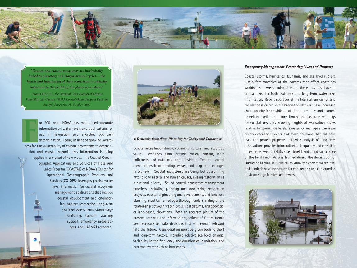
A Dynamic Coastline: Planning for Today and Tomorrow
Coastal areas have intrinsic economic, cultural, and aesthetic value. Wetlands alone provide critical habitat, store pollutants and nutrients, and provide buffers to coastal communities from flooding, waves, and long-term changes in sea level. Coastal ecosystems are being lost at alarming rates due to natural and human causes, raising restoration as a national priority. Sound coastal ecosystem management practices, including planning and monitoring restoration projects, coastal engineering and development, and land-use planning, must be framed by a thorough understanding of the relationship between water levels, tidal datums, and geodetic, or land-based, elevations. Both an accurate picture of the present scenario and informed projections of future trends are necessary to make decisions that will remain relevant into the future. Consideration must be given both to short and long-term factors, including relative sea level change, variability in the frequency and duration of inundation, and extreme events such as hurricanes.
“Coastal and marine ecosystems are intrinsically
linked to planetary and biogeochemical cycles… the
health and functioning of these ecosystems is critically
important to the health of the planet as a whole.”
- From COASTAL, the Potential Consequences of Climate
Variability and Change, NOAA Coastal Ocean Program Decision
Analysis Series No. 21, October 2000
Emergency Management: Protecting Lives and Property
Coastal storms, hurricanes, tsunamis, and sea level rise are just a few examples of the hazards that affect coastlines worldwide. Areas vulnerable to these hazards have a critical need for both real-time and long-term water level information. Recent upgrades of the tide stations comprising the National Water Level Observation Network have increased their capacity for providing real-time storm tides and tsunami detection, facilitating more timely and accurate warnings for coastal areas. By knowing heights of evacuation routes relative to storm tide levels, emergency managers can issue timely evacuation orders and make decisions that will save lives and protect property. Likewise analysis of long-term observations provides information on frequency and elevation of extreme events, relative sea level trends, and subsidence of the local land. As was learned during the devastation of Hurricane Katrina, it is critical to know the correct water level and geodetic baseline datums for engineering and construction of storm surge barriers and levees.