part 4 -- forest roads
TRANSCRIPT

North Carolina Forestry BMP Manual Chapter 5 Amended 2006 Page 78
Caption: This pole crossing uses adequately sized logs to provide support and are free of soil, limbs, or excessive debris. Instead of placing soil atop the pole crossing, wooden road pallet/mats are used here to provide a running surface for the log trucks.
Immediately remove the pole material after the crossing is no longer
needed, or when precipitation is forecast for the watershed area.
Stabilize the crossing location to prevent accelerated erosion or sediment
transport.
Figure 5Z: A pole crossing installed within a dry ditch
for temporary log road access in northeastern North Carolina
Part 4 -- Forest Roads
Roads are necessary for the sustainability of working forests in North Carolina.
The ability to utilize renewable forest resources, enjoy the visual beauty of the
forest, and provide efficient and effective property access are among the most
common needs for forest roads.
However, roads that are poorly planned, constructed or not well maintained are
among the most common origins of sediment within nonpoint source pollution
from forestry activities.
Because of the high potential for sediment problems from forest roads, there
are several state and federal rules or laws requiring that certain practices be
implemented, or actions be taken, to protect water quality.
NOTE: A summary and further explanation of the rules or laws are
provided in Chapter 2 and Appendix 1. Forest roads in wetlands
are discussed in Chapter 6.

North Carolina Forestry BMP Manual Chapter 5 Amended 2006 Page 79
FPG
The FPGs are detailed in Chapter 2 and the
Appendix
Also Refer To:
The Forestry Leaflets and rules citations for DWR buffer rules are in the Appendix 3. Both U.S. Army Corps of Engineers’ documents are in Appendix 1 and further discussed in Chapter 6.
For Forest Owners:
Good forest roads provide many benefits, including:
Adding economic value to your property.
Making property access more efficient, with no unnecessary roads.
Reducing or eliminating the number of stream crossings.
Minimizing or preventing potential long-term and significant erosion risks.
Providing wildlife corridors and firebreaks.
Rules Related to Forest Roads
Forest Practices Guidelines Related to Water Quality (FPGs)
North Carolina General Statute 77-13 and General Statute 77-14
DWR riverbasin and watershed ‘Riparian Buffer Rules’
These buffer rules for specific river basins and watersheds set forest road
limitations within the mandatory buffer zone.
U.S. Army Corps of Engineers 15 mandatory best management practices for forest roads in wetlands as cited within 33 CFR Part 323
Construction of access roads in jurisdictional wetlands for the production of
forest products does not require a Corps’ permit if these 15 best management
practices outlined by the Corps of Engineers are implemented.
U.S. Army Corps of Engineers Information Regarding Compliance with the Federal Clean Water Act Section 404(f)(1) Provisions for the Construction of Forest Roads within Wetlands, in North Carolina This information should be used when planning for and constructing new
forest roads and maintaining existing roads within waters of the U.S. including
streams and wetlands subject to regulation under the Clean Water Act.
North Carolina Dredge and Fill Law
This state law requires that permits be secured for discharges of dredged or fill
material in certain locations within the 20 Coastal Area Management Act
(CAMA) counties. Refer to Chapter 6 for more information on this law.
Forest Road BMPs The following three sections within this Part 3 provide BMPs for planning
roads, constructing roads, and maintaining roads.
Planning: This allows you to establish a road that is best suited for the site
conditions and intended usage while minimizing impacts to the forest
landscape and water quality.
Constructing: Roads should include BMP tools that are outlined in Part 1
and Part 2 of this chapter, or other suitable methods, so water quality is
protected and erosion is controlled.
Maintaining: Roads should be maintained to assure that the variety of
BMP tools you use are still functioning, water quality is protected, and
your investment in the road retains its value.
BMPs for Planning Roads Consider using maps, aerial photos, and your own on-the-ground site
examination to help determine where roads should be placed.
When feasible, plan to construct roads at least one year before usage to
allow the roadbed to stabilize and settle prior to use.

North Carolina Forestry BMP Manual Chapter 5 Amended 2006 Page 80
Did You Know?
Providing sunlight to a road or trail surface is known as ‘daylighting.’
Helpful Hints:
To learn how to measure slope ratio, and how it differs from percent (%) slope, refer to Appendix 6.
FPG
Minimize the number of stream crossings. Avoid crossings when possible.
Minimize soil disturbance and road placement within ephemeral drainages:
-- If roads are needed within an ephemeral drainage, you should consider
using BMPs to control runoff and capture sediment.
Establish roads along the land contours when conditions allow:
-- In steep terrain, try to establish roads along gentle hill slopes, just below
the ridgeline. This allows better runoff control and keeps the road from
downcutting into the ridgeline, which creates an erosion channel.
Try to keep the road atop firm and well-drained soils. Avoid wet-natured
soils, loose soils, or highly erodible soils if possible.
Plan the road to minimize the amount of cut and/or fill needed.
Look for opportunities to naturally drain runoff from the road, but never
directly into streams or other waterbodies. Avoid placing outlets within
ephemerals where possible.
-- Often the best solution in steep terrain is to construct an outsloped road
with broad-based dips or other suitable BMP tools to control runoff.
Plan adequate right-of-way widths to provide ample sunlight for drying the
road surface.
BMPs for Constructing Roads Construct roads at the minimal width that meets your safety and traffic
needs while protecting water quality and allowing adequate runoff control:
-- Travel surfaces of 10 to 14 feet, with intervals of wider road for
passing, are usually suitable for light-duty roads.
-- Travel surfaces from 14 to 20 feet, or slightly more, may be needed for
frequently used roads.
Keep grade slopes to 10 percent or less when conditions allow:
-- For steeper grade slopes, limit road-segment lengths to 200 feet or less
when possible. This allows improved runoff control and capture.
Limit height of side / cut banks to 5 feet or less if possible:
-- For loose soils, the side / cut bank should be sloped at a ratio no steeper
than 2:1 where site conditions allow.
-- For tight soils, a steeper side / cut bank may be acceptable, but
generally should be no steeper than a ratio of ½:1.
-- Roads with side / cut banks steeper than 1:1 or more than 5 feet tall
should only be constructed when no other practical alternative exists.
Minimize soil disturbance and the amount of road at any stream crossings
in accordance with FPG .0201 and FPG .0203. Also see Part 5 of this
Chapter for BMPs on stream crossings.

North Carolina Forestry BMP Manual Chapter 5 Amended 2006 Page 81
FPG
FPG
Also Refer To…
Recommendations on using geotextiles and gravel are in Appendix 4 and 5.
Watch Out!
Full bench construction may require side / cut banks steeper than 2:1.
Caption: This forest road has many BMPs, including: - Outsloped road with broad-based dip (under the rear wheels of the vehicle). - Well vegetated road shoulders and graveled road surface. - Silt fence and roadside berm to capture sediment.
Establish access entrances to public roads in accordance with FPG .0204.
-- Use rock, stone, wooden mats, or other suitable materials for a distance
of at least 50 feet from the public road, if soil conditions require.
Stabilize bare soil areas in accordance with FPG .0209. Also see Chapter
11 for suggestions on establishing groundcover.
In low-lying areas, especially areas prone to flooding, keep the roadbed as
close to the original ground level as possible, to minimize potential
blockage of natural overland surface water flow:
-- When fill material is needed, provide adequate cross drainage.
Use insloping, outsloping and/or crowning techniques as appropriate to
provide drainage from the road surface and control runoff:
-- This may require the excavation of an inside ditchline to carry runoff.
Control and capture runoff.
Stabilize and/or harden the road surface as needed to provide runoff
control and vehicle access. Consider using geotextile fabric as
underlayment.
Consider using full-bench construction in sloping terrain where soil is
loose and prone to sliding or accelerated erosion:
-- A full bench road is cut entirely into the side / cut bank, with all
excavated spoil material hauled away. No spoil is side-cast over the
downslope edge, therefore the roadbed sits entirely upon a solid,
undisturbed soilbank.
Figure 5AA: A forest road with broad-based dip
North Carolina Forestry BMP Manual Chapter 5 Amended 2006 Page 82
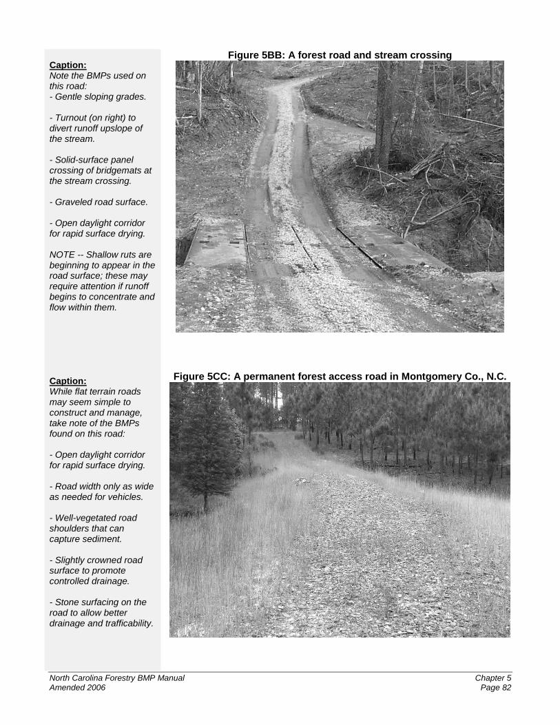
Caption: Note the BMPs used on this road: - Gentle sloping grades. - Turnout (on right) to divert runoff upslope of the stream. - Solid-surface panel crossing of bridgemats at the stream crossing. - Graveled road surface. - Open daylight corridor for rapid surface drying. NOTE -- Shallow ruts are beginning to appear in the road surface; these may require attention if runoff begins to concentrate and flow within them. Caption: While flat terrain roads may seem simple to construct and manage, take note of the BMPs found on this road: - Open daylight corridor for rapid surface drying. - Road width only as wide as needed for vehicles. - Well-vegetated road shoulders that can capture sediment. - Slightly crowned road surface to promote controlled drainage. - Stone surfacing on the road to allow better drainage and trafficability.
Figure 5BB: A forest road and stream crossing
Figure 5CC: A permanent forest access road in Montgomery Co., N.C.

North Carolina Forestry BMP Manual Chapter 5 Amended 2006 Page 83
Caption: This entrance onto a public roadway from a forest road is well stabilized. It appears that the graveled surface of the forest road is adequately stabilizing the road, and providing a rough surface that ‘kicks off’ dirt and mud from truck tires, before entering the public road. NOTE -- Some type of runoff control may be needed near the curve in the forest road, to control runoff before it flows toward the public road.
FPG For Forest Owners:
Limiting access protects the road and its BMPs from damage, and protects your investment. Consider reconstructing, relocating, or ‘retiring’ a road section that proves difficult to maintain, or shows signs of repeated heavy erosion.
Figure 5DD: A public road entrance from a forest road
BMPs for Maintaining Roads Rehabilitate and stabilize the road and side / cut banks according to the
standards of FPG .0209.
Monitor the condition of the road and its BMPs to see if runoff is being
controlled and captured as intended. Take prompt action to protect water
quality if BMPs are not properly functioning.
Clean out built-up silt and sediment as needed from sediment traps, silt
fences, bales, check dams, brush barriers or other places where sediment
poses a risk to water quality.
Maintain an open daylight corridor that provides suitable drying for the
road surface.
Maintain a road surface that provides good runoff control, water quality
protection, and vehicle access.
Close access to roads when suitable to minimize unnecessary use.
If practical, perform road and ditch maintenance during times when heavy
precipitation is not expected, so freshly tilled soil is less likely to be
exposed to runoff flows.