parcel jk design and site plan review cover letter
TRANSCRIPT

B E A L S + T H O M A S BEALS AND THOMAS, INC. T 508.366.0560 Reservoir Corporate Center F 508.366.4391 144 Turnpike Road www.bealsandthomas.com Southborough, MA 01772-2104 Regional Office: Plymouth, MA
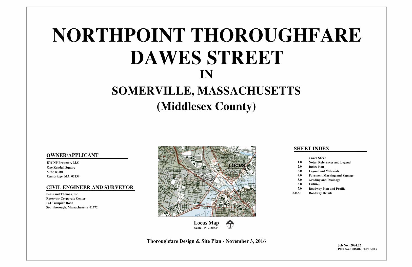
November 3, 2016 Mr. Kevin Prior, Chair Somerville Planning Board City Hall 93 Highland Avenue Somerville, MA 02143 Via: Hand Delivery Reference: Dawes Street Design and Site Plan Review
NorthPoint Somerville, Massachusetts B+T Project No. 2084.02 Dear Chairman Prior and Members of the Board: On behalf of the Applicant, DW NP Property, LLC (an affiliate of DivcoWest), Beals and Thomas, Inc. respectfully submits this Design and Site Plan Review (DSP) Application for Dawes Street (the Site), which is part of the larger NorthPoint development partially located in Somerville, Massachusetts. The proposed development is the construction of an approximately 415-foot section of thoroughfare located in Somerville. Dawes Street will be a newly constructed thoroughfare as part of the larger NorthPoint roadway network. The attached application is submitted in accordance with the City of Somerville requirements for Design and Site Plan Review, pursuant to Section 5.4 of the City of Somerville Zoning Ordinance (SZO). As part of the DSP Application, we have submitted the following materials for review by the Somerville Planning Board:
• Completed Application for Design and Site Plan Submission;
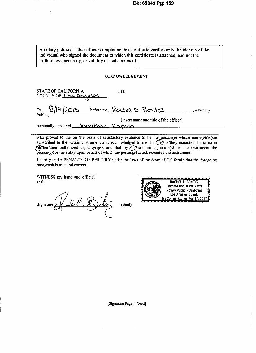
• Legal Description of the Property; • Property Title Report; • Property Deed; • Locus Map; • Requested Waivers;
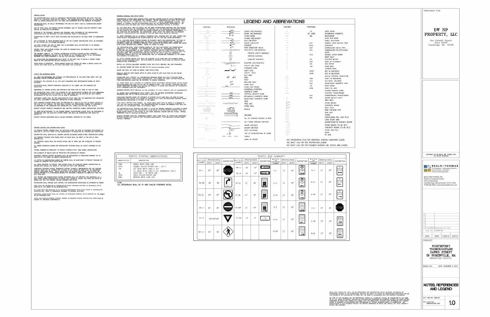
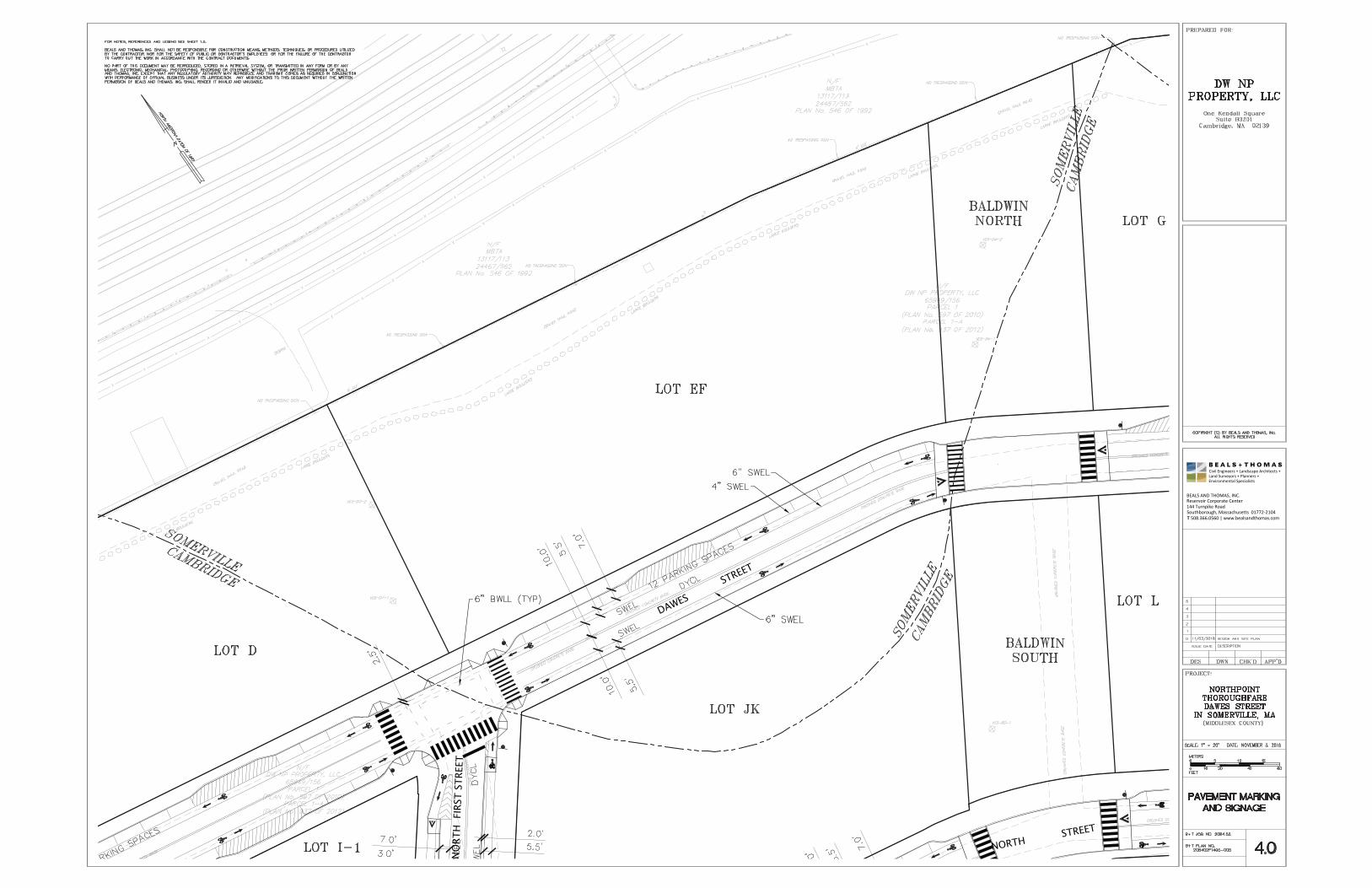
• Development Plan; • Construction Management Program; • Twenty-scale Site Plans and Details; • Traffic Management Plans; and • Utility and Slope Cross Sections.

Mr. Kevin Prior, Chair Somerville Planning Board November 3, 2016 Page 2 CONTACT INFORMATION OF THE DEVELOPMENT TEAM Owner/Applicant: DivcoWest One Kendall Square Suite B3201 Cambridge, MA 02139 Mark Johnson, Director of Development (617) 914-8600 [email protected] Development Advisor: The HYM Investment Group, LLC One Congress Street 11th Floor Boston, MA 02114 Michael L. Barowsky, Vice President - Development (617) 248-8905 [email protected] Traffic Engineer: Vanasse Hangen Brustlin, Inc. 99 High Street, 10th Floor Boston, MA 02110 Susan P. Sloan-Rossiter, Principal (617) 607-2930 [email protected] Landscape Architect: Michael Van Valkenburgh Associates, Inc. 231 Concord Avenue Cambridge, MA 02138 Herb Sweeney, Senior Associate (617) 864-2076 [email protected]
Civil Engineer: Beals and Thomas, Inc. 144 Turnpike Road Southborough, MA 01772 John P. Gelcich, Senior Planner (508) 366-0560 [email protected] Legal Counsel: Goulston & Storrs, PC 400 Atlantic Avenue Boston, MA 02110 Deborah S. Horwitz, Esquire (617) 574-4123 [email protected] Legal Counsel: Galluccio & Watson, LLP 1498 Cambridge Street Cambridge, MA 02139 Anthony D. Galluccio, Partner and Founder (617) 945-2577 [email protected]
Mr. Kevin Prior, Chair Somerville Planning Board November 3, 2016 Page 3 LEGAL DESCRIPTION OF PROPERTY Three certain parcels of land in the Commonwealth of Massachusetts, County of Middlesex, City of Somerville, situated on the southeasterly boundary of the City of Somerville common with the City of Cambridge and shown in part on a plan recorded at the Middlesex County Registry of Deeds as plan 937 of 2012. More particularly bounded and described as follows:
First Parcel Beginning at a point at the most northeasterly corner of the parcel herein described, thence running;
Westerly 1026 feet more or less by the city boundary between the City of
Somerville and City of Cambridge, said course being by the centerline of the former Millers River channel, to a point, thence turning and running;
S 81º 14’ 38” E 488 feet more or less to a point, thence turning and running; S 77º 22’ 25” E 264 feet more or less to the point of beginning, said last two courses
being by land now or formerly of MBTA.
Containing 3.46 acres, more or less. Second Parcel Beginning at a point at the most northeasterly corner of the parcel herein described, said point being N 81º 14’ 38” W 327 feet more or less from the most westerly corner of the first parcel, thence running; Westerly 579 feet more or less by the city boundary between the City of Somerville
and City of Cambridge, said course being by the centerline of the former Millers River channel, to a point, thence turning and running;
S 81º 14’ 38” E 521 feet more or less to the point of beginning, said last course being by
land now or formerly of MBTA.
Containing 0.87 acres, more or less. Third Parcel Beginning at a point at the most northeasterly corner of the parcel herein described, said point being N 81º 14’ 38” W 258 feet more or less from the most westerly corner of the second parcel, thence running;
Westerly 317 feet more or less by the city boundary between the City of
Somerville and City of Cambridge, said course being by the centerline
Mr. Kevin Prior, Chair Somerville Planning Board November 3, 2016 Page 4
of the former Millers River channel, to a point, thence turning and running;
N 02º 23’ 37” W 28 feet more or less to a point, thence turning and running; S 67º 40’ 27” E 42.82 feet to a point, thence turning and running; S 81º 14’ 38” E 203 feet more or less to the point of beginning, said last three courses
being by land now or formerly of MBTA.
Containing 0.37 acres, more or less.
ZONING CONFORMANCE REVIEW The Site is located in the North Point Special District and is subject to the requirements of Section 6.6 – North Point Special District of the SZO. Dawes Street has been designed in conformance with Section 6.6.5 – Thoroughfares. There are no legal judgments, action, covenants, conditions, or restrictions that control the proposed development. REQUESTED WAIVERS OR VARIANCES DivcoWest is seeking approval of a waiver from Section 6.6.5.C.4.c of the SZO, requiring street trees to be “planted within the furnishing zone in a regularly-spaced allee pattern no greater than thirty (30) feet on center” to Section 6.6.5.C.4.f of the SZO, allows for a waiver from street tree requirements to be granted by the Planning Board if the sidewalk is located in front of a terminated vista. The portion of sidewalk for which this waiver is requested is in front of North First Street, a terminated vista. DEVELOPMENT PLAN A development plan for construction is attached to this application. A construction management program is included as part of this application.
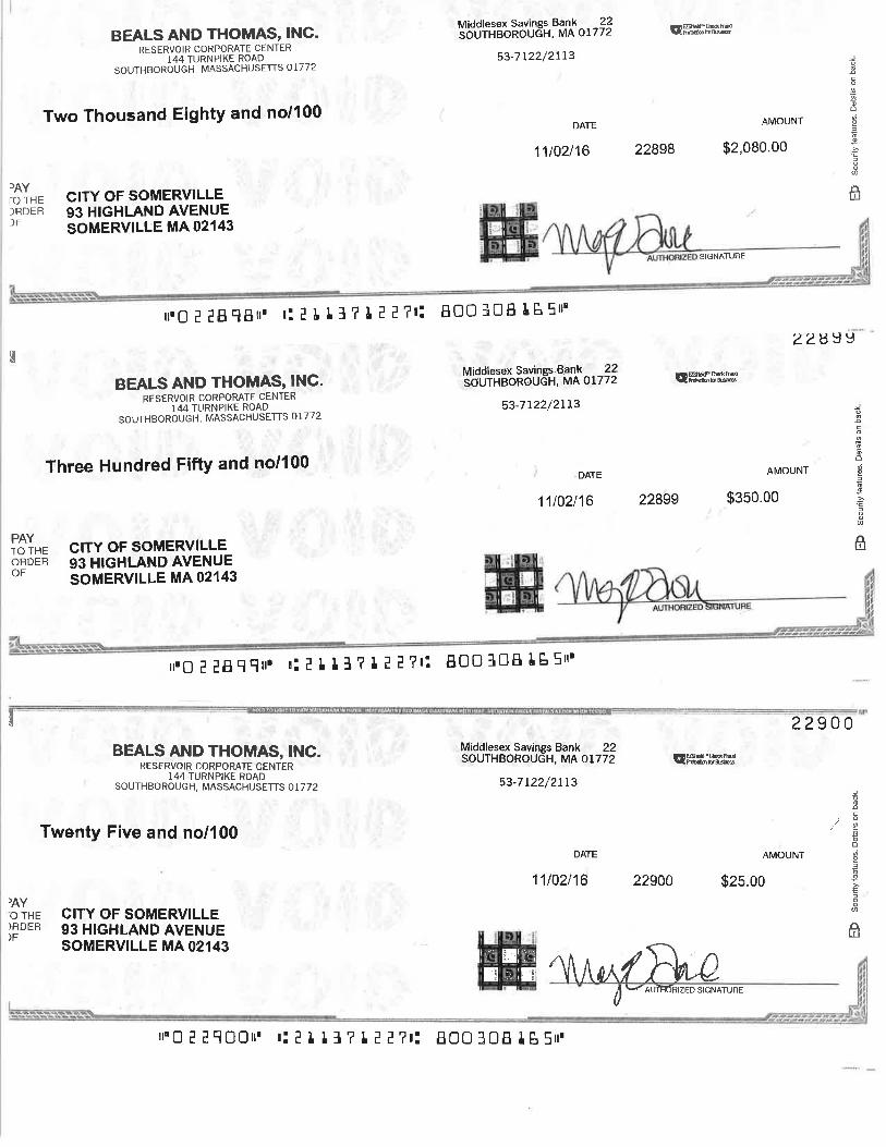
We have included a check made out to the City of Somerville in the amount of $2,080.00 as required for the filing fees associated with Design and Site Plan Review, as well as a check in the amount of $350.00 for the legal advertisement fee and $25.00 for the abutter notification fee. We understand that the Planning Director will provide the requisite notice to Parties in Interest advertising the public hearing associated with this request.
Mr. Kevin Prior, Chair Somerville Planning Board November 3, 2016 Page 5 We look forward to meeting with the Planning Board to review and discuss the proposed project. Thank you for your consideration of this application. Very truly yours, BEALS AND THOMAS, INC. John P. Gelcich, AICP Senior Planner Enclosures JPG/mks/208402LT073
Page 2 of 9
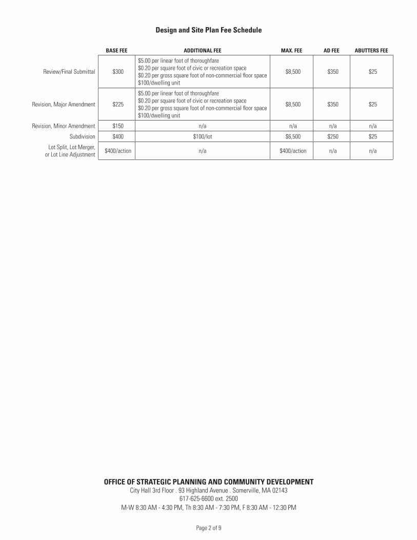
Design and Site Plan Fee Schedule
BASE FEE ADDITIONAL FEE MAX. FEE AD FEE ABUTTERS FEE
Review/Final Submittal $300
$5.00 per linear foot of thoroughfare$0.20 per square foot of civic or recreation space$0.20 per gross square foot of non-commercial floor space$100/dwelling unit
$8,500 $350 $25
Revision, Major Amendment $225
$5.00 per linear foot of thoroughfare$0.20 per square foot of civic or recreation space$0.20 per gross square foot of non-commercial floor space$100/dwelling unit
$8,500 $350 $25
Revision, Minor Amendment $150 n/a n/a n/a n/a
Subdivision $400 $100/lot $6,500 $250 $25
Lot Split, Lot Merger, or Lot Line Adjustment $400/action n/a $400/action n/a n/a
OFFICE OF STRATEGIC PLANNING AND COMMUNITY DEVELOPMENTCity Hall 3rd Floor . 93 Highland Avenue . Somerville, MA 02143
617-625-6600 ext. 2500M-W 8:30 AM - 4:30 PM, Th 8:30 AM - 7:30 PM, F 8:30 AM - 12:30 PM
Page 3 of 9
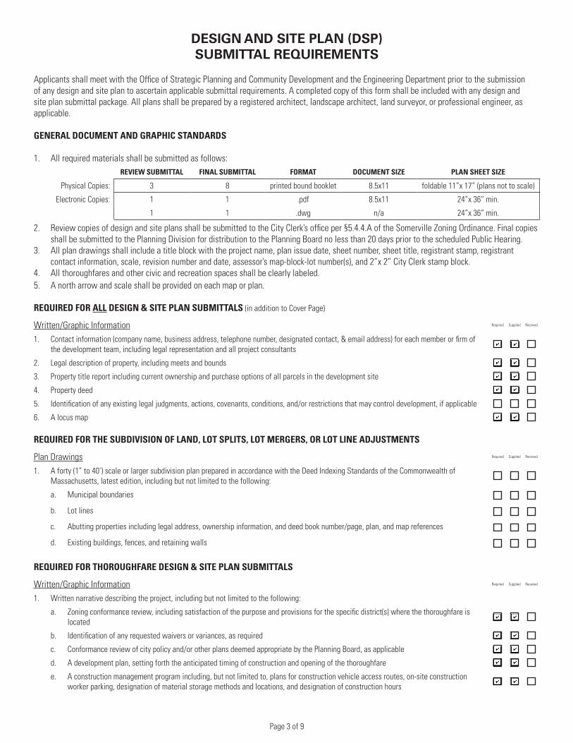
DESIGN AND SITE PLAN (DSP)SUBMITTAL REQUIREMENTS
Applicants shall meet with the Office of Strategic Planning and Community Development and the Engineering Department prior to the submission of any design and site plan to ascertain applicable submittal requirements. A completed copy of this form shall be included with any design and site plan submittal package. All plans shall be prepared by a registered architect, landscape architect, land surveyor, or professional engineer, as applicable.
GENERAL DOCUMENT AND GRAPHIC STANDARDS
1. All required materials shall be submitted as follows:REVIEW SUBMITTAL FINAL SUBMITTAL FORMAT DOCUMENT SIZE PLAN SHEET SIZE
Physical Copies: 3 8 printed bound booklet 8.5x11 foldable 11”x 17” (plans not to scale)
Electronic Copies: 1 1 .pdf 8.5x11 24”x 36” min.
1 1 .dwg n/a 24”x 36” min.
2. Review copies of design and site plans shall be submitted to the City Clerk’s office per §5.4.4.A of the Somerville Zoning Ordinance. Final copies shall be submitted to the Planning Division for distribution to the Planning Board no less than 20 days prior to the scheduled Public Hearing.
3. All plan drawings shall include a title block with the project name, plan issue date, sheet number, sheet title, registrant stamp, registrant contact information, scale, revision number and date, assessor’s map-block-lot number(s), and 2”x 2” City Clerk stamp block.
4. All thoroughfares and other civic and recreation spaces shall be clearly labeled.5. A north arrow and scale shall be provided on each map or plan.
REQUIRED FOR ALL DESIGN & SITE PLAN SUBMITTALS (in addition to Cover Page)
Written/Graphic Information Required Supplied Received
1. Contact information (company name, business address, telephone number, designated contact, & email address) for each member or firm of the development team, including legal representation and all project consultants
2. Legal description of property, including meets and bounds
3. Property title report including current ownership and purchase options of all parcels in the development site
4. Property deed
5. Identification of any existing legal judgments, actions, covenants, conditions, and/or restrictions that may control development, if applicable
6. A locus map
REQUIRED FOR THE SUBDIVISION OF LAND, LOT SPLITS, LOT MERGERS, OR LOT LINE ADJUSTMENTS
Plan Drawings Required Supplied Received
1. A forty (1” to 40’) scale or larger subdivision plan prepared in accordance with the Deed Indexing Standards of the Commonwealth of Massachusetts, latest edition, including but not limited to the following:
a. Municipal boundaries
b. Lot lines
c. Abutting properties including legal address, ownership information, and deed book number/page, plan, and map references
d. Existing buildings, fences, and retaining walls
REQUIRED FOR THOROUGHFARE DESIGN & SITE PLAN SUBMITTALS
Written/Graphic Information Required Supplied Received
1. Written narrative describing the project, including but not limited to the following:
a. Zoning conformance review, including satisfaction of the purpose and provisions for the specific district(s) where the thoroughfare is located
b. Identification of any requested waivers or variances, as required
c. Conformance review of city policy and/or other plans deemed appropriate by the Planning Board, as applicable
d. A development plan, setting forth the anticipated timing of construction and opening of the thoroughfare
e. A construction management program including, but not limited to, plans for construction vehicle access routes, on-site construction worker parking, designation of material storage methods and locations, and designation of construction hours
Page 4 of 9
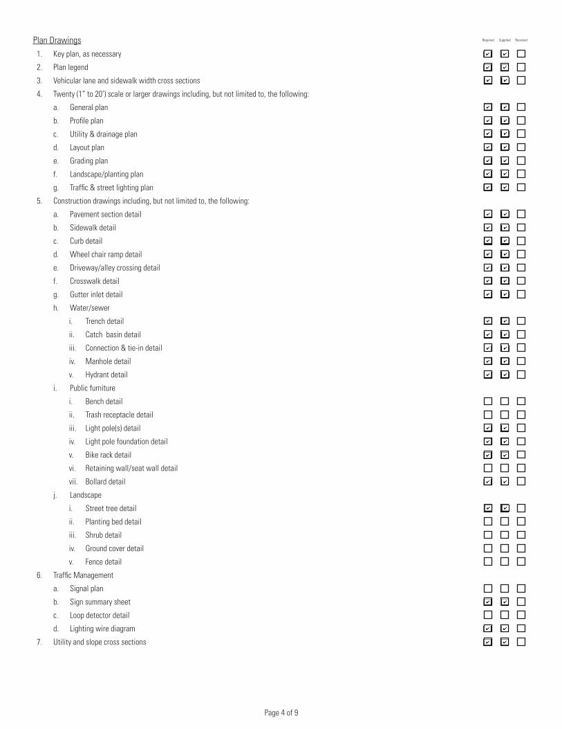
Plan Drawings Required Supplied Received
1. Key plan, as necessary
2. Plan legend
3. Vehicular lane and sidewalk width cross sections
4. Twenty (1” to 20’) scale or larger drawings including, but not limited to, the following:
a. General plan
b. Profile plan
c. Utility & drainage plan
d. Layout plan
e. Grading plan
f. Landscape/planting plan
g. Traffic & street lighting plan
5. Construction drawings including, but not limited to, the following:
a. Pavement section detail
b. Sidewalk detail
c. Curb detail
d. Wheel chair ramp detail
e. Driveway/alley crossing detail
f. Crosswalk detail
g. Gutter inlet detail
h. Water/sewer
i. Trench detail
ii. Catch basin detail
iii. Connection & tie-in detail
iv. Manhole detail
v. Hydrant detail
i. Public furniture
i. Bench detail
ii. Trash receptacle detail
iii. Light pole(s) detail
iv. Light pole foundation detail
v. Bike rack detail
vi. Retaining wall/seat wall detail
vii. Bollard detail
j. Landscape
i. Street tree detail
ii. Planting bed detail
iii. Shrub detail
iv. Ground cover detail
v. Fence detail
6. Traffic Management
a. Signal plan
b. Sign summary sheet
c. Loop detector detail
d. Lighting wire diagram
7. Utility and slope cross sections

Page 5 of 9
REQUIRED FOR CIVIC SPACE DESIGN & SITE PLAN SUBMITTALS
Written/Graphic Information Required Supplied Received
1. Written narrative describing the project, including but not limited to the following:
a. Identification of the proposed space by type
b. Description of the intended built character guiding the design of the space
c. Zoning conformance review, including satisfaction of the purpose and provisions for the specific district(s) where the civic or recreation space is located
d. Identification of any requested special permits or variance, as required
e. Conformance review of city policy and/or other plans deemed appropriate by the Planning Board, as applicable
f. A development plan, setting forth the anticipated timing of construction and opening of the proposed space
g. A construction management program including, but not limited to, plans for construction vehicle access routes, on-site construction worker parking, designation of material storage methods and location, and designation of construction hours
2. A shadow study illustrating shadows cast by surrounding buildings according to the City of Somerville’s Illustrating Building Shadows requirements.
Plan Drawings Required Supplied Received
1. Neighborhood civic space plan, if applicable, identifying the subject space within the plan
2. Twenty (1” to 20’) scale or larger plan drawings including, but not limited to, the following:
a. Existing conditions
b. Site preparation/demolition plan
c. Materials plan
d. Layout plan
e. Paving plan
f. Grading/drainage plan
g. Utilities plan
h. Landscape/planting plan
i. Electrical & lighting plan
j. Irrigation plan
3. Construction drawings including, but not limited to, the following:
a. Paving surfaces detail
b. Curb and edges detail
c. Walls and fencing detail
d. Public furniture
i. Seating detail
ii. Trash receptacle detail
iii. Light pole(s) detail
iv. Light pole foundation detail
v. Bike rack detail
vi. Bollard detail
e. Landscape
i. Tree planting detail
ii. Planting bed detail
iii. Shrub detail
iv. Ground cover detail
4. Illustrated plant list
Page 6 of 9
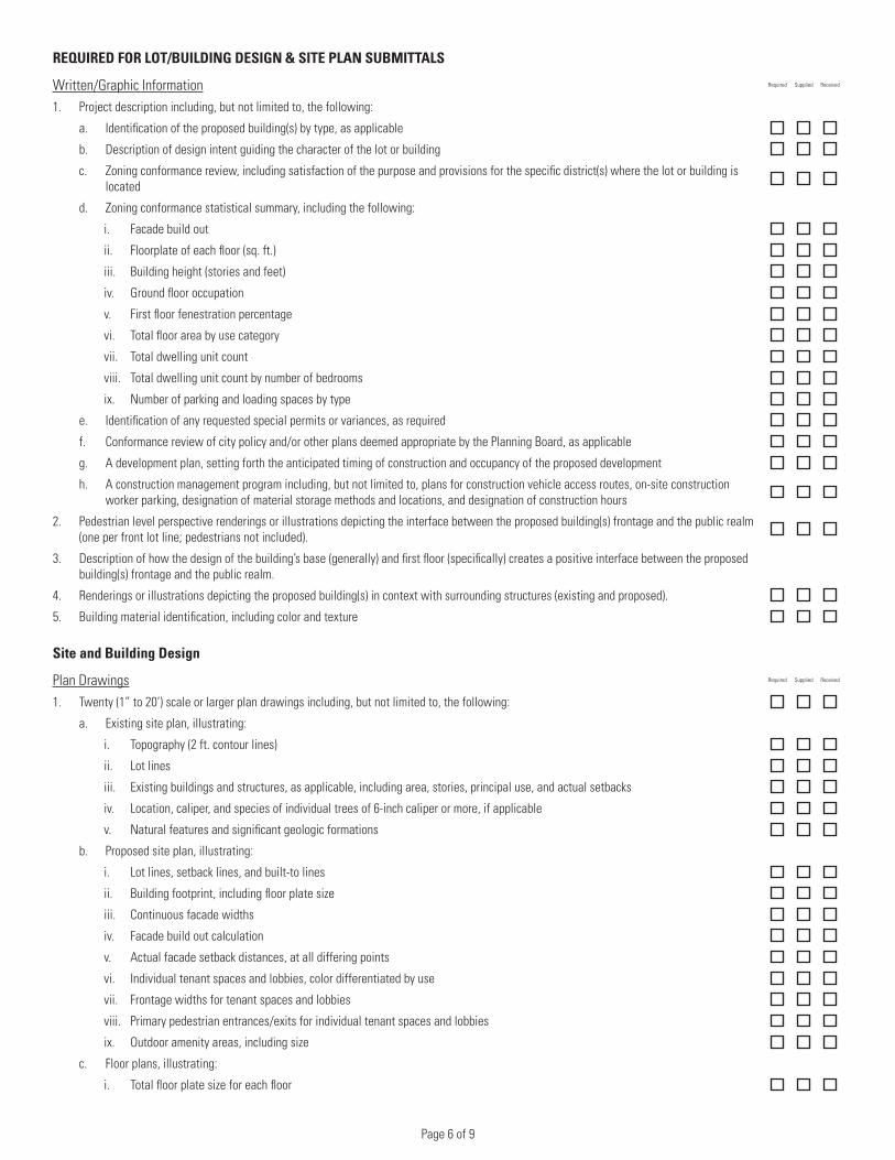
REQUIRED FOR LOT/BUILDING DESIGN & SITE PLAN SUBMITTALS
Written/Graphic Information Required Supplied Received
1. Project description including, but not limited to, the following:
a. Identification of the proposed building(s) by type, as applicable
b. Description of design intent guiding the character of the lot or building
c. Zoning conformance review, including satisfaction of the purpose and provisions for the specific district(s) where the lot or building is located
d. Zoning conformance statistical summary, including the following:
i. Facade build out
ii. Floorplate of each floor (sq. ft.)
iii. Building height (stories and feet)
iv. Ground floor occupation
v. First floor fenestration percentage
vi. Total floor area by use category
vii. Total dwelling unit count
viii. Total dwelling unit count by number of bedrooms
ix. Number of parking and loading spaces by type
e. Identification of any requested special permits or variances, as required
f. Conformance review of city policy and/or other plans deemed appropriate by the Planning Board, as applicable
g. A development plan, setting forth the anticipated timing of construction and occupancy of the proposed development
h. A construction management program including, but not limited to, plans for construction vehicle access routes, on-site construction worker parking, designation of material storage methods and locations, and designation of construction hours
2. Pedestrian level perspective renderings or illustrations depicting the interface between the proposed building(s) frontage and the public realm (one per front lot line; pedestrians not included).
3. Description of how the design of the building’s base (generally) and first floor (specifically) creates a positive interface between the proposed building(s) frontage and the public realm.
4. Renderings or illustrations depicting the proposed building(s) in context with surrounding structures (existing and proposed).
5. Building material identification, including color and texture
Site and Building Design
Plan Drawings Required Supplied Received
1. Twenty (1” to 20’) scale or larger plan drawings including, but not limited to, the following:
a. Existing site plan, illustrating:
i. Topography (2 ft. contour lines)
ii. Lot lines
iii. Existing buildings and structures, as applicable, including area, stories, principal use, and actual setbacks
iv. Location, caliper, and species of individual trees of 6-inch caliper or more, if applicable
v. Natural features and significant geologic formations
b. Proposed site plan, illustrating:
i. Lot lines, setback lines, and built-to lines
ii. Building footprint, including floor plate size
iii. Continuous facade widths
iv. Facade build out calculation
v. Actual facade setback distances, at all differing points
vi. Individual tenant spaces and lobbies, color differentiated by use
vii. Frontage widths for tenant spaces and lobbies
viii. Primary pedestrian entrances/exits for individual tenant spaces and lobbies
ix. Outdoor amenity areas, including size
c. Floor plans, illustrating:
i. Total floor plate size for each floor
Page 7 of 9
Required Supplied Received
ii. Individual uses/spaces, color differentiated by use, for each floor (residential units should be color differentiated by bedroom count)
iii. Indoor and outdoor amenity areas, including size
d. Ground level landscape plan, including:
i. Plant schedule
ii. Illustrated plant list
iii. Electrical and lighting plan
2. Building sections (one per front lot line), illustrating:
a. Individual floors, color differentiated by use
b. Height measurements, including the height of each story and building height in total
3. Facade/elevation renderings (all sides), illustrating:
a. Vertical and horizontal articulation of each facade (in full)
b. Fenestration pattern of each facade (in full), including solid to void analysis for each floor
c. Close-up of the building’s base (one per front lot line)
4. Construction drawings including, but not limited to, the following:
a. Pavement section detail
b. Sidewalk detail
c. Curb detail
d. Wheel chair ramp detail
e. Driveway/alley crossing detail
f. Furnishings
i. Bench detail
ii. Trash receptacle detail
iii. Light pole(s) and light pole foundation detail(s)
iv. Bike rack detail
v. Retaining wall/seat wall detail
vi. Bollard detail
g. Landscape
i. Street tree detail
ii. Planting bed detail
iii. Shrub detail
iv. Ground cover detail
v. Fence Detail
Page 8 of 9
Transportation Analysis
Written/Graphic Information Required Supplied Received
1. Summary of the proposed development program for the lot or building
2. Identification of existing conditions:
a. Site specific (including adjacent thoroughfares and building facades across the street from the site):
i. Site access (pedestrian entrances to individual ground floor spaces and lobbies)
ii. Primary pedestrian routes
iii. Bicycling routes/lanes/paths, including all existing ground level bicycle parking
iv. Pavement markings including parking and loading areas, driveways, and circulation
v. On-street motor vehicle parking inventory, by type (metered, handicapped, no-parking, etc.)
b. Within a quarter (1/4) mile study area:
i. Public transportation including location, types, and service and ridership statistics for study area stations/stops
ii. Bicycling routes/lanes/paths
iii. Car and bicycle sharing locations
iv. Off-street motor vehicle parking inventory, by type (surface lot, above ground structure, underground structure)
3. Proposed future conditions:
a. Site specific (including adjacent thoroughfares and building facades across the street from the site):
i. Pedestrian, bicycle, and roadway infrastructure improvements
ii. Site access (pedestrian entrances to individual ground floor spaces and lobbies)
iii. Proposed curb cut or sidewalk changes, if applicable
iv. Short and long term bicycle parking/storage
v. Vehicular circulation, maneuvering, and access to the site/building(s)
vi. Off-street motor vehicle parking inventory, including layout, access, count, and size
vii. Car and bicycle sharing locations
viii. On-street motor vehicle parking inventory, by type (metered, handicapped, no-parking, etc.)
ix. Loading docks
b. Within a quarter (1/4) mile study area
i. Pedestrian, bicycle, and roadway infrastructure improvements
4. A multi-modal transportation demand analysis of existing and proposed future conditions following procedures outlined in the 2010 Highway Capacity Manual. Analysis shall include study of demand, capacity, trip distribution, and circulation for sidewalks, bike facilities, public transportation, travel lanes, and intersections for appropriate modes. AM, PM, and daily trip generation rates and modal splits shall be based on regional comparables of similar principal uses provided by the Office of Strategic Planning and Community Development or other sources deemed appropriate by the Planning Board. In the absence of applicable comparables, ITE Trip Generation (latest edition) data may be substituted.
5. A transportation demand management plan describing measures taken to encourage the reduction of single-occupancy vehicular trips including, but not limited to, the following:
a. Ride-sharing incentives and information dissemination
b. Set-asides for high-occupancy-vehicles, including number and location
c. Mass transit information dissemination
d. MBTA pass sales and subsidies
e. Direct station links or pedestrian connections
f. Encouragement of flexible work hours
g. Restrictions on service and good deliveries
6. A transportation demand monitoring plan
Page 9 of 9
Infrastructure Analysis
Written/Graphic Information Required Supplied Received
1. Estimated water and electricity consumption, sewage generation, and energy requirements for the building(s)
2. Analysis of the capacity and adequacy of existing water, storm water drainage, and sewer, energy (including gas), and electrical communications (including telephone, fire alarm, computer, cable, etc) utility systems, and identification of required system upgrades or connections to accommodate the proposed development. Impacts due to any required system upgrades or connections requiring a significant public or utility investment, creating a significant disruption in vehicular or pedestrian circulation, or affecting any civic or recreation space or streetscape improvements shall be described.
Plan Drawings Required Supplied Received
1. Twenty (1” to 20’) scale or larger utility plan drawing identifying all existing and proposed utilities including but not limited to water, sanitary sewer, storm drainage, electrical, telephone, data, CATV, and natural gas utilities.
2. Construction drawings including, but not limited to, the following:
a. Water/sewer
i. Trench detail
ii. Catch basin detail
iii. Connection & tie-in detail
iv. Manhole detail
v. Hydrant detail
vi. Detention basin and outlet detail
vii. Infiltration device detail
Environmental Analysis
Written/Graphic Information Required Supplied Received
1. Identification of existing M.G.L. Chapter 21E reports and/or other environmental assessments, analysis, clean-up studies, enforcement actions, or related documentation related to the site
2. Shadow analysis illustrating both existing and net new shadows according to the City of Somerville’s Illustrating Building Shadows requirements
3. Wind analysis documenting potential pedestrian level winds (PLW’s) adjacent to and in the vicinity of the project site according to the City of Somerville’s Measuring Pedestrian Level Wind Impacts and identification of proposed mitigation for any uncomfortable winds generated at outdoor pedestrian areas
4. Solar glare analysis ensuring that no visual impairment or discomfort is caused on nearby thoroughfares, civic and recreation spaces, or pedestrian areas and that no solar heat buildup is caused in any nearby buildings due to reflective spot glare
5. Air quality analysis verifying that emissions from any parking facility and/or building heating and mechanical systems will not violate state or federal ambient air quality standards
6. Construction impact analysis and management program including, but not limited to, the following:
a. A study of and mitigation plan for impacts on public safety from noise, dust, pollutant emissions, waste generation and disposal, and
b. plans for construction vehicle access routes, on-site construction worker parking, designation of material storage methods and locations, and designation of construction hours
c. A plan for solid and hazardous waste removal identifying any known toxic or hazardous wastes on or buried in the development site, pursuant to the requirements of M.G.L. Chapter 21E
d. Analysis of sub-soil conditions, the potential for ground movement and settlement during construction, and the impact on adjacent buildings and utility lines and a description of foudation construction methodology
e. Analysis of the impact of construction on groundwater levels and resulting effects on surrounding structures and building foundations
This Commitment is invalid unless the Insuring Provisions and Schedules A and B are attached.
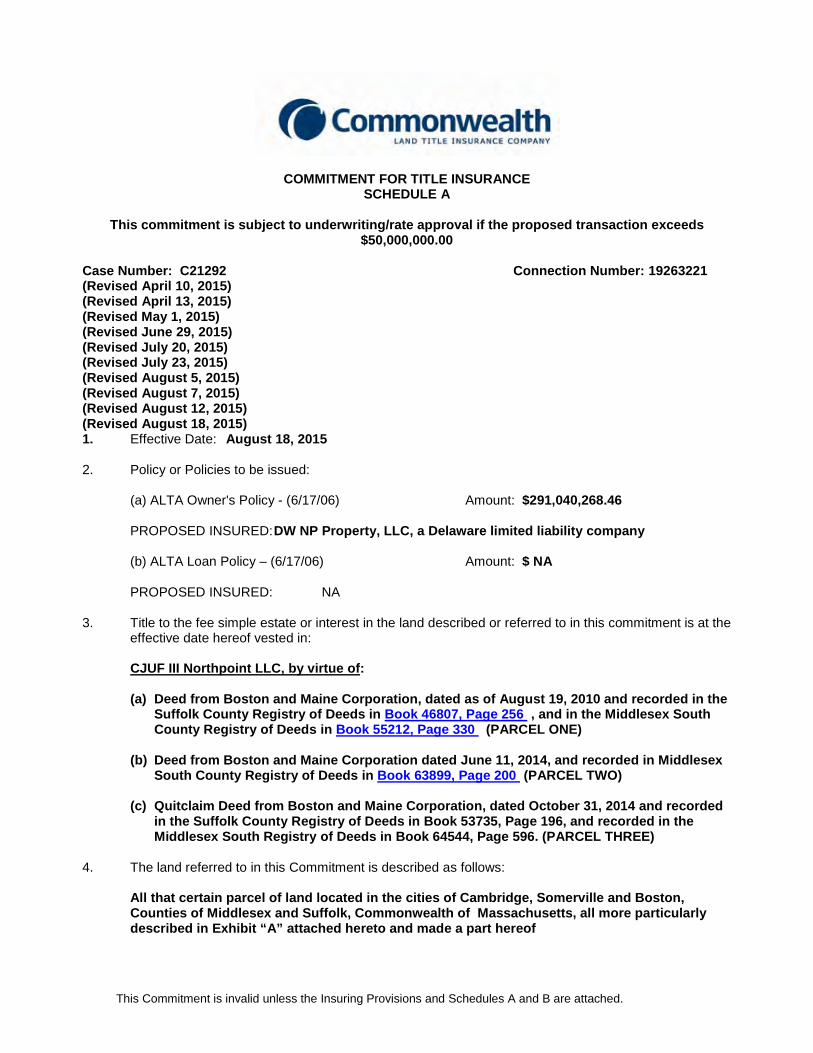
COMMITMENT FOR TITLE INSURANCE SCHEDULE A
This commitment is subject to underwriting/rate approval if the proposed transaction exceeds
$50,000,000.00 Case Number: C21292 Connection Number: 19263221 (Revised April 10, 2015) (Revised April 13, 2015) (Revised May 1, 2015) (Revised June 29, 2015) (Revised July 20, 2015) (Revised July 23, 2015) (Revised August 5, 2015) (Revised August 7, 2015) (Revised August 12, 2015) (Revised August 18, 2015) 1. Effective Date: August 18, 2015
2. Policy or Policies to be issued:
(a) ALTA Owner's Policy - (6/17/06) Amount: $291,040,268.46
PROPOSED INSURED: DW NP Property, LLC, a Delaware limited liability company (b) ALTA Loan Policy – (6/17/06) Amount: $ NA
PROPOSED INSURED: NA
3. Title to the fee simple estate or interest in the land described or referred to in this commitment is at the effective date hereof vested in:
CJUF III Northpoint LLC, by virtue of: (a) Deed from Boston and Maine Corporation, dated as of August 19, 2010 and recorded in the
Suffolk County Registry of Deeds in Book 46807, Page 256 , and in the Middlesex South County Registry of Deeds in Book 55212, Page 330 (PARCEL ONE)
(b) Deed from Boston and Maine Corporation dated June 11, 2014, and recorded in Middlesex South County Registry of Deeds in Book 63899, Page 200 (PARCEL TWO)
(c) Quitclaim Deed from Boston and Maine Corporation, dated October 31, 2014 and recorded
in the Suffolk County Registry of Deeds in Book 53735, Page 196, and recorded in the Middlesex South Registry of Deeds in Book 64544, Page 596. (PARCEL THREE)
4. The land referred to in this Commitment is described as follows:
All that certain parcel of land located in the cities of Cambridge, Somerville and Boston,
Counties of Middlesex and Suffolk, Commonwealth of Massachusetts, all more particularly described in Exhibit “A” attached hereto and made a part hereof
This Commitment is invalid unless the Insuring Provisions and Schedules A and B are attached.
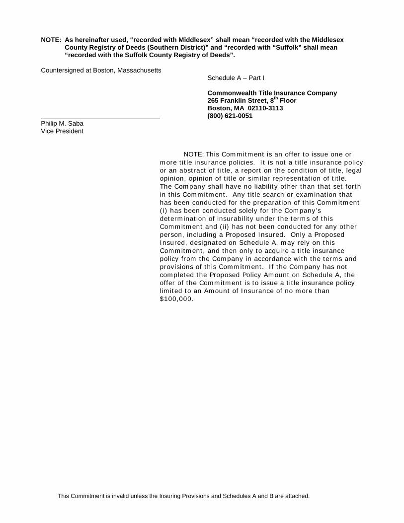
NOTE: As hereinafter used, “recorded with Middlesex” shall mean “recorded with the Middlesex County Registry of Deeds (Southern District)” and “recorded with “Suffolk” shall mean “recorded with the Suffolk County Registry of Deeds”.
Countersigned at Boston, Massachusetts
Schedule A – Part I Commonwealth Title Insurance Company 265 Franklin Street, 8th Floor Boston, MA 02110-3113
(800) 621-0051 Philip M. Saba Vice President
NOTE: This Commitment is an offer to issue one or more title insurance policies. It is not a title insurance policy or an abstract of title, a report on the condition of title, legal opinion, opinion of title or similar representation of title. The Company shall have no liability other than that set forth in this Commitment. Any title search or examination that has been conducted for the preparation of this Commitment (i) has been conducted solely for the Company’s determination of insurability under the terms of this Commitment and (ii) has not been conducted for any other person, including a Proposed Insured. Only a Proposed Insured, designated on Schedule A, may rely on this Commitment, and then only to acquire a title insurance policy from the Company in accordance with the terms and provisions of this Commitment. If the Company has not completed the Proposed Policy Amount on Schedule A, the offer of the Commitment is to issue a title insurance policy limited to an Amount of Insurance of no more than $100,000.
This Commitment is invalid unless the Insuring Provisions and Schedules A and B are attached.
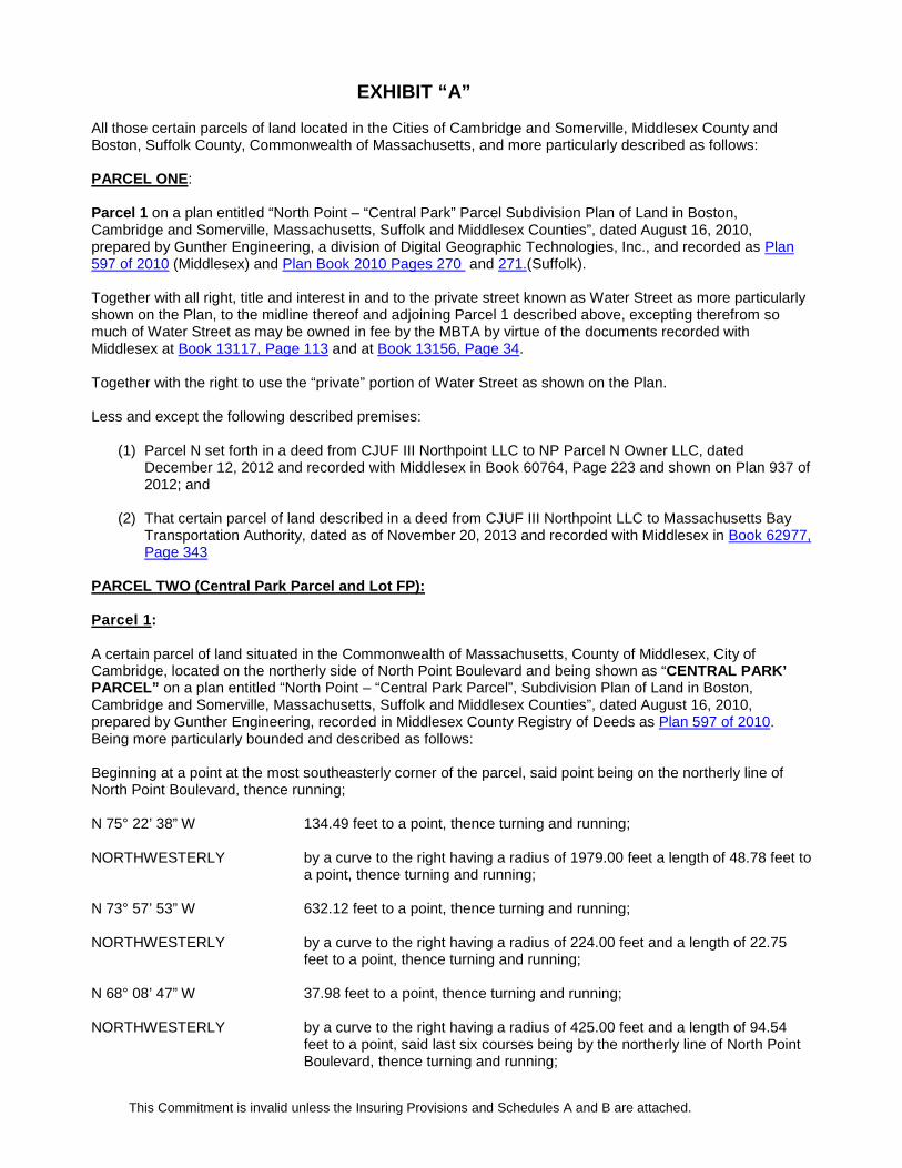
EXHIBIT “A” All those certain parcels of land located in the Cities of Cambridge and Somerville, Middlesex County and Boston, Suffolk County, Commonwealth of Massachusetts, and more particularly described as follows: PARCEL ONE: Parcel 1 on a plan entitled “North Point – “Central Park” Parcel Subdivision Plan of Land in Boston, Cambridge and Somerville, Massachusetts, Suffolk and Middlesex Counties”, dated August 16, 2010, prepared by Gunther Engineering, a division of Digital Geographic Technologies, Inc., and recorded as Plan 597 of 2010 (Middlesex) and Plan Book 2010 Pages 270 and 271.(Suffolk). Together with all right, title and interest in and to the private street known as Water Street as more particularly shown on the Plan, to the midline thereof and adjoining Parcel 1 described above, excepting therefrom so much of Water Street as may be owned in fee by the MBTA by virtue of the documents recorded with Middlesex at Book 13117, Page 113 and at Book 13156, Page 34. Together with the right to use the “private” portion of Water Street as shown on the Plan. Less and except the following described premises:
(1) Parcel N set forth in a deed from CJUF III Northpoint LLC to NP Parcel N Owner LLC, dated December 12, 2012 and recorded with Middlesex in Book 60764, Page 223 and shown on Plan 937 of 2012; and
(2) That certain parcel of land described in a deed from CJUF III Northpoint LLC to Massachusetts Bay Transportation Authority, dated as of November 20, 2013 and recorded with Middlesex in Book 62977, Page 343
PARCEL TWO (Central Park Parcel and Lot FP): Parcel 1:
A certain parcel of land situated in the Commonwealth of Massachusetts, County of Middlesex, City of Cambridge, located on the northerly side of North Point Boulevard and being shown as “CENTRAL PARK’ PARCEL” on a plan entitled “North Point – “Central Park Parcel”, Subdivision Plan of Land in Boston, Cambridge and Somerville, Massachusetts, Suffolk and Middlesex Counties”, dated August 16, 2010, prepared by Gunther Engineering, recorded in Middlesex County Registry of Deeds as Plan 597 of 2010. Being more particularly bounded and described as follows: Beginning at a point at the most southeasterly corner of the parcel, said point being on the northerly line of North Point Boulevard, thence running; N 75° 22’ 38” W 134.49 feet to a point, thence turning and running; NORTHWESTERLY by a curve to the right having a radius of 1979.00 feet a length of 48.78 feet to
a point, thence turning and running; N 73° 57’ 53” W 632.12 feet to a point, thence turning and running; NORTHWESTERLY by a curve to the right having a radius of 224.00 feet and a length of 22.75
feet to a point, thence turning and running; N 68° 08’ 47” W 37.98 feet to a point, thence turning and running; NORTHWESTERLY by a curve to the right having a radius of 425.00 feet and a length of 94.54
feet to a point, said last six courses being by the northerly line of North Point Boulevard, thence turning and running;

This Commitment is invalid unless the Insuring Provisions and Schedules A and B are attached.
N 57° 16’ 47” W 256.98 feet to a point, thence turning and running; N 11° 15’ 41” E 91.06 feet to a point, thence turning and running; S 81° 14’ 36” E 200.13 feet to a point, thence turning and running; S 73° 25’ 09” E 14.60 feet to a point, thence turning and running; S 81° 06’ 44” E 67.29 feet to a point, thence turning and running; S 74° 39’ 04” E 33.61 feet to a point, thence turning and running; S 81° 14’ 36” E 178.52 feet to a point, thence turning and running; S 85° 07’ 47” E 40.27 feet to a point, thence turning and running; NORTHEASTERLY by a curve to the right having a radius of 319.00 feet and a length of 105.10
feet to a point, thence turning and running; S 58° 22’ 52” E 128.90 feet to a point, thence turning and running; S 51° 45’ 29” E 30.35 feet to a point, thence turning and running; S 58° 22’ 52” E 137.29 feet to a point, thence turning and running; S 64° 25’ 22” E 33.25 feet to a point, thence turning and running; S 58° 22’ 52” E 273.25 feet to a point, thence turning and running; SOUTHEASTERLY by a curve to the right having a radius of 30.08 feet and a length of 47.17 feet
to a point, thence turning and running; S 31° 28’ 09” W 35.15 feet to a point, thence turning and running; SOUTHWESTERLY by a curve to the right having a radius of 4.00 feet and a length of 5.11 feet to
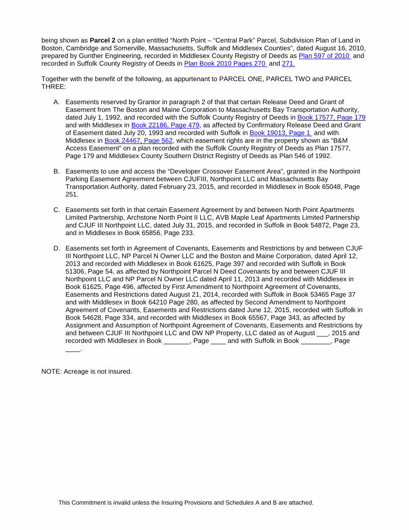
the point of beginning. All of said courses being by Parcel 1. Parcel 2: A certain parcel of land situated in the City of Cambridge, County of Middlesex, Commonwealth of Massachusetts, being more particularly shown as "Lot FP" on a plan entitled "Condominium Site Plan of Sierra & Tango Condominium in Cambridge, Massachusetts, Middlesex County, Scale 1" = 30', 10 January 2008, Gunther Engineering", recorded with the Middlesex S. D. Registry of Deeds as Plan No. 449 of 2008. Together with the benefit of the following which are appurtenant to PARCEL ONE AND PARCEL TWO:
a. Easements granted in Agreement of Covenants, Easements and Restrictions by and between CJUF III Northpoint LLC, Sierra Plus Tango LLC, as Trustee of Sierra + Tango Condominium Trust and Boston and Maine Corporation, dated April 1, 2011 and recorded with Middlesex in Book 56683, Page 375, and recorded with Suffolk in Book 47761, Page 232, as amended by First Amendment dated December 12, 2012 and recorded with Middlesex in Book 60764, Page 220, as affected by Assignment and Assumption of Northpoint Agreement of Covenants, Easements and Restrictions by and between CJUF III Northpoint LLC and DW NP Property, LLC dated as of August ___, 2015 and recorded with Middlesex in Book _______, Page ____ and with Suffolk in Book ________, Page __.
PARCEL THREE: A certain parcel of land situated partly in the City of Cambridge and partly in the City of Boston, Commonwealth of Massachusetts, Counties of Middlesex and Suffolk, located on Charlestown Avenue and
This Commitment is invalid unless the Insuring Provisions and Schedules A and B are attached.
being shown as Parcel 2 on a plan entitled “North Point – “Central Park” Parcel, Subdivision Plan of Land in Boston, Cambridge and Somerville, Massachusetts, Suffolk and Middlesex Counties”, dated August 16, 2010, prepared by Gunther Engineering, recorded in Middlesex County Registry of Deeds as Plan 597 of 2010 and recorded in Suffolk County Registry of Deeds in Plan Book 2010 Pages 270 and 271. Together with the benefit of the following, as appurtenant to PARCEL ONE, PARCEL TWO and PARCEL THREE:
A. Easements reserved by Grantor in paragraph 2 of that that certain Release Deed and Grant of Easement from The Boston and Maine Corporation to Massachusetts Bay Transportation Authority, dated July 1, 1992, and recorded with the Suffolk County Registry of Deeds in Book 17577, Page 179 and with Middlesex in Book 22186, Page 479, as affected by Confirmatory Release Deed and Grant of Easement dated July 20, 1993 and recorded with Suffolk in Book 19013, Page 1 and with Middlesex in Book 24467, Page 562, which easement rights are in the property shown as “B&M Access Easement” on a plan recorded with the Suffolk County Registry of Deeds as Plan 17577, Page 179 and Middlesex County Southern District Registry of Deeds as Plan 546 of 1992.
B. Easements to use and access the “Developer Crossover Easement Area”, granted in the Northpoint Parking Easement Agreement between CJUFIII, Northpoint LLC and Massachusetts Bay Transportation Authority, dated February 23, 2015, and recorded in Middlesex in Book 65048, Page 251.
C. Easements set forth in that certain Easement Agreement by and between North Point Apartments Limited Partnership, Archstone North Point II LLC, AVB Maple Leaf Apartments Limited Partnership and CJUF III Northpoint LLC, dated July 31, 2015, and recorded in Suffolk in Book 54872, Page 23, and in Middlesex in Book 65856, Page 233.
D. Easements set forth in Agreement of Covenants, Easements and Restrictions by and between CJUF
III Northpoint LLC, NP Parcel N Owner LLC and the Boston and Maine Corporation, dated April 12, 2013 and recorded with Middlesex in Book 61625, Page 397 and recorded with Suffolk in Book 51306, Page 54, as affected by Northpoint Parcel N Deed Covenants by and between CJUF III Northpoint LLC and NP Parcel N Owner LLC dated April 11, 2013 and recorded with Middlesex in Book 61625, Page 496, affected by First Amendment to Northpoint Agreement of Covenants, Easements and Restrictions dated August 21, 2014, recorded with Suffolk in Book 53465 Page 37 and with Middlesex in Book 64210 Page 280, as affected by Second Amendment to Northpoint Agreement of Covenants, Easements and Restrictions dated June 12, 2015, recorded with Suffolk in Book 54628, Page 334, and recorded with Middlesex in Book 65567, Page 343, as affected by Assignment and Assumption of Northpoint Agreement of Covenants, Easements and Restrictions by and between CJUF III Northpoint LLC and DW NP Property, LLC dated as of August ___, 2015 and recorded with Middlesex in Book _______, Page ____ and with Suffolk in Book ________, Page ____.
NOTE: Acreage is not insured.

This Commitment is invalid unless the Insuring Provisions and Schedules A and B are attached.
COMMITMENT FOR TITLE INSURANCE
SCHEDULE B - SECTION 1
REQUIREMENTS Case Number: C21292 The following are the requirements to be complied with: 1. Payment to or for the account of the grantors or mortgagors of the full consideration for the estate or
interest to be insured.
2. Proper instrument(s) creating the estate or interest to be insured must be executed and duly filed for record to-wit:
(a) Duly authorized and executed deed from the party identified in Schedule A, Item 3, vesting
fee title in the proposed insured owner; and
Note: Section 6 of Notices of Acitivity and Use Limitations referenced in Schedule B, Section 2 below should be reviewed when drafting any conveyance documents.
3. Intentionally omitted.
4. If Survey coverage is requested, prior to closing the company must be in receipt of a satisfactory
survey and surveyor’s report. The Survey exceptions set forth in Schedule B, Section 2, standard exception 2 will be eliminated or amended in accordance with the facts disclosed thereby.
5. Receipt of properly executed Parties in Possession and Mechanic’s Lien Affidavit in order to delete or
modify exceptions set forth in Schedule B, Section 2, Standard Exceptions 1 and 3.
6. If the insured premises have undergone construction or repair in the past 93 days, satisfactory evidence should be provided at or prior to closing that said improvements and/or repairs or alterations are complete and; that the contractor, subcontractors, labor and material men are all paid in full.
7. In the event that the Company will be responsible for recording the closing documents,
(a) at least 24 hours before closing, provide this office with a copy of the form of deed, mortgage,
and all other documents to be recorded; and (b) along with the original documents for recording, provide this office with two copy sets of all
documents to be recorded. 8. Issuance of a final title insurance policy is conditioned upon payment of all title premium(s) due in
connection with said policy(ies) at the present applicable rates as well as all examination and counsel fees and recording costs and charges incurred by the Company relative to this transaction.
(Continued) Schedule B – Section 1 Page 1
This Commitment is invalid unless the Insuring Provisions and Schedules A and B are attached.
Schedule B – Section 1 Case No: C21292 Requirements Continued 9. If the title to be vested in, or documents are to be executed by a LIMITED PARTNERSHIP, a current
Certificate of limited partnership naming the General Partners (“Long Legal with General Partners”) from the Secretary of State’s of the Commonwealth of Massachusetts must be recorded/filed.
10. If title to be vested in or documents to be executed by a LIMITED LIABILITY COMPANY, provide a
current Certificate of Good Standing for the LLC from the Massachusetts Secretary of State identifying: (a) the managers of the limited liability company, if any; (b) those persons who are authorized to act with respect to real estate instruments; and (c) In the event that nobody is so authorized to execute real estate documents, obtain and
record/file a certificate executed by the manager of the limited liability company stating that the persons executing the deed/mortgage in the name of the limited liability company are the incumbent members or managers and that such persons are empowered by the Operating Agreement to convey/mortgage the insured premises.
(d) There may be circumstances in which an LLC does not have managers and the identity of persons authorized to execute real estate documents is not disclosed in the Secretary of State filing. In those circumstances, the statute provides that a good faith third party purchaser may rely upon a certificate executed by a person identified at the Secretary of State’s Office as a manager or as a person authorized to execute documents to be filed with the Secretary of State certifying as to (i) the incumbency of any manager or member and (ii) the authority of any persons to act on behalf of the LLC whether or not such person is identified in the Secretary of State filing. M.G.L. c. 156C, s. 67. Such a certificate shall be binding upon the LLC in favor of a person relying in good faith thereon notwithstanding inconsistent provisions in the operating agreement. M.G.L. c. 156C, s. 67. The protection afforded by the statute applies equally to domestic LLC’s and foreign LLC’s, which have registered with the Secretary of State.
11. With respect to CJUF III Northpoint LLC (Seller), provide a current original Certificate of Good
Standing for the LLC from the Massachusetts Secretary of State identifying:
(a) the managers of the limited liability company, if any; (b) those persons who are authorized to act with respect to real estate instruments; and (c) In the event that nobody is so authorized to execute real estate documents, obtain and
record/file a certificate executed by the manager of the limited liability company stating that the persons executing the deed/mortgage in the name of the limited liability company are the incumbent members or managers and that such persons are empowered by the Operating Agreement to convey/mortgage the insured premises.
(d) There may be circumstances in which an LLC does not have managers and the identity of persons authorized to execute real estate documents is not disclosed in the Secretary of State filing. In those circumstances, the statute provides that a good faith third party purchaser may rely upon a certificate executed by a person identified at the Secretary of State’s Office as a manager or as a person authorized to execute documents to be filed with the Secretary of State certifying as to (i) the incumbency of any manager or member and (ii) the authority of any persons to act on behalf of the LLC whether or not such person is identified in the Secretary of State filing. M.G.L. c. 156C, s. 67. Such a certificate shall be binding upon the LLC in favor of a person relying in good faith thereon notwithstanding inconsistent provisions in the operating agreement. M.G.L. c. 156C, s. 67. The protection afforded by the statute applies equally to domestic LLC’s and foreign LLC’s, which have registered with the Secretary of State.
Note: In the event the Seller is classified for the taxable year as a corporation for federal
income tax purposes, the Company must be in receipt of a Commonwealth of Massachusetts, Department of Revenue, Waivers of Excise Tax Lien if the parcel described in Schedule A constitutes all or substantially all of the assets of the seller. If

This Commitment is invalid unless the Insuring Provisions and Schedules A and B are attached.
the seller will NOT be conveying all or substantially all of their assets in Massachusetts, the Deed should contain statement to that effect. If the seller is not classified for the taxable year as a corporation for federal income tax purposes, then the Deed should contain a statement to that effect. (Mass. St. 2008, c. 173, s. 27, amending M.G.L. c. 62C, s. 51).
12. Upon full disclosure to the Company of the nature and scope of this transaction and our review and
approval of the closing documents, including updated certifications of title, the Company reserves the right to raise such other and further exceptions and requirements as it deems appropriate.
13. Duly authorized and executed Discharge/Termination of the following items: NONE
This Commitment is invalid unless the Insuring Provisions and Schedules A and B are attached.
COMMITMENT FOR TITLE INSURANCE SCHEDULE B - SECTION 2
EXCEPTIONS FROM COVERAGE
Case Number: C21292 The policy or policies to be issued will contain exceptions to the following unless the same are disposed of to the satisfaction of the Company: 1. Rights of the following parties as tenants or licensees only, with no right or option to purchase any
portion of the land (schedule of tenants to be provided to Company). 2. Intentionally omitted. 3. Intentionally omitted. 4. Intentionally omitted. 5. Liens for taxes and municipal charges which become due and payable subsequent to the date of said
policy.
6. Right of others legally entitled thereto to use the “private” portion of Water Street as shown on the Plan referred to in Exhibit A above (affects the portion of PARCEL ONE within Water Street as shown on the ALTA Survey (defined below).
7. Electric Utility Easement from Ogden Realty Limited Partnership to Cambridge Electric Light Company dated June 22, 1989 and recorded with Middlesex in Book 19905, Page 539. (Affects PARCEL ONE and Parcel 1 of PARCEL TWO only) This Policy insures that this Easement is located as shown on the ALTA Survey and affects only East Street and a portion of the property adjacent thereto, as shown on the Exhibit A sketch attached to the easement set forth above.
8. Report and Findings of the Superior Court Commission on the Abolition of Grade Crossing recorded August 4, 1900 with Suffolk in Book 2700, Page 243, affecting the location of Austin Street and the draw bridge over the Millers River at the Prison Point Bridge and Report and Findings of the Special Commission on the Alterations of the Grade Crossing of Prison Point Street in Cambridge dated March 29, 1899 and recorded May 2, 1900 with Middlesex in Book 2815, Page 145, establishing the layout of Prison Point Street in Cambridge to Austin Street in Boston over a viaduct 50 feet wide. This Policy insures that the documents referred to in this Item affect only the land located under the “Prison Point Bridge” a/k/a Gilmore Bridge as shown on the ALTA Survey.
9. Prison Point Bridge Taking dated September 25, 1972 by the Commonwealth of Massachusetts, Metropolitan District Commission, and recorded with Suffolk in Book 8540, Page 651 and recorded with Middlesex in Book 12222, Page 250. This Policy insures that this Taking affects only the land located under the “Prison Point Bridge” a/k/a Gilmore Bridge and a strip of land adjacent thereto, as shown on the ALTA Survey.
This Commitment is invalid unless the Insuring Provisions and Schedules A and B are attached.
10. Agreement regarding drainage set forth in Paragraph 6 of the Release Deed and Grant of Easement between the Boston and Maine Corporation and the Massachusetts Bay Transportation Authority dated July 1, 1992 and recorded with Suffolk in Book 17577, Page 179 and with Middlesex in Book 22186, Page 479, as affected by Confirmatory Release Deed and Grant of Easement dated July 20, 1993 and recorded with Suffolk in Book 19013, Page 1 and with Middlesex in Book 24467, Page 562
11. Easements for access set forth in Deed from the Boston and Maine Railroad to Keith Fulton & Sons, Inc. dated September 14, 1961 and recorded with Middlesex in Book 9891, Page 128, as affected by the City of Cambridge Taking for public parking and transportation dated November 10, 1980 and recorded with Middlesex in Book 14151, Page 141. This Policy insures that the rights and easements referred to in this Item affect East Street and the 40’ wide Access Drive as shown on the ALTA Survey. This policy further insures that the rights to use East Street do not extend into any portion of the Central Park Parcel.
12. Easement set forth in Deed from the Boston and Maine Railroad to Leo Pistorino dated December 24, 1964 and recorded with Middlesex in Book 10721, Page 201, conveying the area shown on the plan recorded with Middlesex in Book 10699, Page End, as is affected by rights granted by Leo M. Pistorino, et al, Trustees to P.W. Rounsevell, Inc. by deed dated August 22, 1966 and recorded with Middlesex in Book 11193, Page 436, as further affected by rights granted by Leo M. Pistorino et al, Trustees to Pappas industrial Properties, Inc. by deed dated October 13, 1977 and recorded with Middlesex in Book 13309, Page 047, as further affected by rights granted by Leo M. Pistorino, et al, Trustees to Bornstein & Fisher, Inc. by deed dated January 16, 1978 and recorded with Middlesex in Book 13375, Page 339.
This Policy insures that the rights and easements in No. 12 above affect only that portion of East Street shown on the ALTA Survey.
13. Taking of Utility Easement by the Commonwealth of Massachusetts by its Division of Capital Planning and Operations dated March 27, 1987 and recorded with Middlesex in Book 17987, Page 054, as affected by Assignment dated March 27, 1987 to Cambridge Electric Light Company recorded with Middlesex in Book 17987, Page 057, which utility easements are located as shown on the ALTA Survey.
14. Terms and provisions of M.G.L. Chapter 40, Section 54A.
15. Ownership of Prison Point (Gilmore) Bridge by the Commonwealth of Massachusetts, which is located as shown on the ALTA Survey.
16. Easement for utility purposes from Boston and Maine Corporation et al to Verizon New England Inc. dated December 29, 2006 and recorded with Middlesex in Book 49883, Page 423, as affected by Consent and Joinder recorded with Middlesex in Book 49883, Page 433, and as further affected by First Amendment to Easement, dated July 17, 2015, and recorded in Suffolk in Book 54808, Page 257, and in Middlesex in Book 65780, Page 442, located as shown on the ALTA Survey.
17. Easement for utility purposes from Boston and Maine Corporation et al to NStar Gas Company dated December 29, 2006 and recorded with Middlesex in Book 49883, Page 437, as affected by Consent and Joinder recorded in Book 49883, Page 445, located as shown on the ALTA Survey and affects only the private ways shown on the ALTA Survey.
18. Easement for utility purposes from Boston and Maine Corporation et al to Comcast of Massachusetts I, LLC dated December 29, 2006 and recorded with Middlesex in Book 49883, Page 447, as affected by Consent and Joinder recorded with Middlesex in Book 49883, Page 454 , located as shown on the ALTA Survey and affects only the private ways as shown on the ALTA Survey.
19. Easement for utility purposes from Boston and Maine Corporation et al to Cambridge Electric Light Company dated December 29, 2006 and recorded with Middlesex in Book 49883, Page 474, as affected by Consent and Joinder recorded in Book 49883, Page 485, located as shown on the ALTA Survey and affects only the private ways as shown on the ALTA Survey.as shown on the Survey.
This Commitment is invalid unless the Insuring Provisions and Schedules A and B are attached.
20. Intentionally omitted.
21. Rights of Clear Channel Outdoor Inc., pursuant to a license dated May 1, 2012 relative to the Billboard located on PARCEL ONE, as shown on the ALTA Survey, and any and all claims arising thereunder.
22. Intentionally omitted.
23. Intentionally omitted.
24. Intentionally omitted.
25. Easements, covenants, conditions and restrictions, including but not limited to common area assessments and charges set forth in Agreement of Covenants, Easements and Restrictions by and between CJUF III Northpoint LLC, Sierra Plus Tango LLC, as Trustee of Sierra + Tango Condominium Trust, and Boston and Maine Corporation, dated April 1, 2011 and recorded in Book 56683, Page 375 (Middlesex) and Book 47761, Page 232 (Suffolk), as affected by First Amendment dated December 12, 2012 and recorded with Middlesex in Book 60764, Page 220.
26. Easements, covenants, conditions and restrictions, including but not limited to common area
assessments and charges set forth in Agreement of Covenants, Easements and Restrictions by and between CJUF III Northpoint LLC, NP Parcel N Owner LLC and the Boston and Maine Corporation, dated April 12, 2013 and recorded with Middlesex in Book 61625, Page 397 and recorded with Suffolk in Book 51306, Page 54, as affected by Northpoint Parcel N Deed Covenants by and between CJUF III Northpoint LLC and NP Parcel N Owner LLC dated April 11, 2013 and recorded with Middlesex in Book 61625, Page 496, affected by First Amendment To Northpoint Agreement of Covenants, Easements and Restrictions recorded In Suffolk Book 53465 Page 37 and in Middlesex in Book 64210 Page 280, as affected by Second Amendment to Northpoint Agreement of Covenants, Easements and Restrictions, recorded with Suffolk in Book 54628, Page 334, and recorded in Middlesex in Book 65567, Page 343.
27. Notice of Activity and Use Limitation by Boston and Maine Corporation dated June 13, 2013 and recorded in Book 62072, Page 281 (affects Parcel 2 of PARCEL TWO), as shown on the ALTA Survey.
28. Notice of Activity and Use Limitation by Boston and Maine Corporation dated June 13, 2013 and
recorded with Middlesex in Book 62072, Page 314 (affects Parcel 1 of PARCEL TWO), as shown on the ALTA Survey.
29. Rights of others to use a private way delineated as the “50’ Wide Access Drive (formerly East Street)
on the Subdivision Plan of Land recorded as Plan 597 of 2010) for all purposes for which streets or ways are used in the City of Cambridge, however, said rights of others do not extend to any portion of the land located within the bounds of Central Park Parcel, as shown on the ALTA Survey.
30. Easement for Electric Service by and between NP Parcel Owner LLC, CJUF III Northpoint LLC and Boston and Maine Corporation to NStar Electric Company, dated December 11, 2013 and recorded in Book 63310, Page 347 (affects Parcel One), which easement is located as shown on the ALTA Survey, as affected by First Amended to Easement for Electric Service, dated June 16, 2015, and recorded in Middlesex in Book 65660, Page 84.
31. Sewer and Drainage Taking for sewer and drainage easements dated July 10, 1975 by the Commonwealth of Massachusetts, Metropolitan District Commission, and recorded with Suffolk in Book 8801, Page 515 and recorded with Middlesex in Book 12828, Page 392, which easements are located as shown on the ALTA Survey (Affects Parcel Three only).
32. Intentionally omitted.
This Commitment is invalid unless the Insuring Provisions and Schedules A and B are attached.
33. Development Regulatory Agreement between Boston Redevelopment Authority and CJUF III Northpoint LLC dated July 29, 2014 and recorded with Suffolk in Book 53319, Page 90 (Affects Parcel One and Parcel Three only).
34. Terms and provisions of a Lease by and CJUF III Northpoint LLC (Landlord) and Sierra Plus Tango LLC (Tenant) dated April 1, 2012, a Notice of which is recorded with Middlesex in Book 60222, Page 132.
35. Intentionally omitted.
36. Planning Board Decision issued by the City of Somerville October 16, 2014, and recorded in Middlesex in Book 64661, Page 25.
37. Notice of Activity and Use Limitation recorded with Middlesex in Book 62072, Page 351.(Affects a portion of PARCEL ONE as shown on the ALTA Survey)
38. Intentionally omitted.
NOTE: Although specifically excluded from the coverage of this policy, the following matters a and b, which are recorded with the Middlesex South District Registry of Deeds, are provided for informational purposes only:
a. Order of Conditions dated June 29, 1992 issued by the Somerville Conservation Commission
in favor of Massachusetts Bay Transportation Authority and Boston and Maine Railroad and recorded November 4, 1992 in Book 22580, Page 215.
b. MA DEP Permit for Sewer System Extension recorded with Middlesex in Book 58497, Page 1. 39. Intentionally omitted.
40. Intentionally omitted.
41. Intentionally omitted.
42. Intentionally omitted.
43. Intentionally omitted.
44. Intentionally omitted.
45. Intentionally omitted.
46. Zoning Decision, City of Cambridge Planning Board Case No. 179, Notice of which is recorded with
Middlesex in Book 44824, Page 370, as affected by Minor Amendment No. 1, recorded in Book 62918, Page 289, as further affected by Minor Amendment No. 2, recorded in Book 62918, Page 306, as further affected by Amendment No. 3 (Major), recorded in Book 62918, Page 308, as affected by City of Cambridge Planning Board Notice of Decision, dated February 13, 2015 and recorded in the Suffolk County Registry of Deeds in Book 54166, Page 121, and in the Middlesex South County Registry of Deeds in Book 65040, Page 490, as affected by Decision by the City of Cambridge Planning Board, dated recorded in Book 65040, Page 490.
47. Intentionally omitted. 48. Intentionally omitted.
49. Survey entitled “ALTA/ACSM Land Title Survey, Northpoint in Cambridge and Somerville, MA
(Middlesex County), and Boston, MA (Suffolk County), dated April 10, 2015, last revised August --, 2015, prepared by Beals and Thomas, Inc, (the “ALTA Survey”) discloses the following matters:
a. There is an underground oil pipe crossing the property line;

This Commitment is invalid unless the Insuring Provisions and Schedules A and B are attached.
b. There are various drain lines crossing the property line;
c. There are overhead wires crossing the property line;
d. There is a guardrail crossing the property line;
e. There is a fence encroaching onto land now or formerly of MBTA;
f. There are concrete blocks encroaching onto land now or formerly of MBTA;
g. There are various water lines crossing the property line;
h. Intentionally omitted;
i. There is a fence and gate crossing the property line;
j. Intentionally omitted;
k. There are gravel roadways crossing the property line;
l. The BIT. Conc. Drive is located outside of the access easement;
m. There are three (3) 48” steel pipes that enter the premises;
n. Intentionally omitted;
o. There is a concrete footing below grade that extends over the property line
approximately 0.7 feet;
p. Intentionally omitted;
q. There is a jersey barrier wall encroaching onto land now or formerly of AVB Maple Leaf Apartments L.P. by approx. 0.2’;
r. There is a utility pole located on land now or formerly of MBTA and overhead
wires crossing the property line;
s. There is an edge of pavement and parking stripes encroaching onto the premises from land now or formerly of MBTA;
t. There is a sewer line crossing onto land now or formerly of MBTA;
u. There is an electric line crossing onto land now or formerly of MBTA;
v. There is access and parking stripes crossing the property line between land
now or formerly of MBTA and CJUF III Northpoint LLC; w. Intentionally omitted;
x. Intentionally omitted;
y. There is a wood and metal pile straddling the property line between land now
or formerly CJUF III Northpoint LLC and MBTA;
z. There is debris located on the premises and crossing the property line between land now or formerly of CJUF III Northpoint LLC and MBTA;
aa. Intentionally omitted;

This Commitment is invalid unless the Insuring Provisions and Schedules A and B are attached.
bb. The concrete wall with cap extends over the property line by 0.02’;
cc. The concrete wall with cap extends over the property line by 0.10’; and
dd. The building façade extends over the property line by 0.07’. 50. Intentionally omitted.
51. Northpoint Parking Easement Agreement, dated February 23, 2015, by and between CJUF III
Northpoint LLC and the Massachusetts Bay Transportation Authority, recorded with the Middlesex South County Registry of Deeds in Book 65048, Page 251.
52. Easement Agreement (Drainage Infrastructure) by and between CJUF III Northpoint LLC and the Massachusetts Bay Transportation Authority, dated May 12, 2015, and recorded in Middlesex in Book 65383 Page 1 and recorded in Suffolk in Book 54469, Page 275
53. Notice of Activity and Use Limitation, dated July 20, 2015, and recorded in Middlesex in Book 65752, Page 408.
54. Easement Agreement by and between North Point Apartments Limited Partnership, Archstone North Point II LLC, AVB Maple Leaf Apartments Limited Partnership and CJUF III Northpoint LLC, dated July 31, 2015 and recorded in Suffolk in Book 54872, Page 23, and in Middlesex in Book 65856, Page 233.
NOTE: If policy is to be issued in support of a mortgage loan, attention is directed to the fact that the Company can assume no liability
under its policy, the closing instructions, or Insured Closing Service for compliance with the requirements of any consumer credit protection or truth in lending law in connection with said mortgage loan.
NOTE: This commitment omits any covenant, condition or restriction referred to above which is based on race, color, religion, sex,
handicap, familial status or national origin, unless and only to the extent that the restriction is not in violation of state or federal law, or relates to a handicap, but does not discriminate against handicapped people.

This Commitment is invalid unless the Insuring Provisions and Schedules A and B are attached.

This Commitment is invalid unless the Insuring Provisions and Schedules A and B are attached.
This Commitment is invalid unless the Insuring Provisions and Schedules A and B are attached.

This Commitment is invalid unless the Insuring Provisions and Schedules A and B are attached.


LOCUS
Civil Engineers + Landscape Architects +Land Surveyors + Planners +Environmental Specialists
BEALS AND THOMAS, INC.Reservoir Corporate Center144 Turnpike RoadSouthborough, Massachusetts 01772-2104T 508.366.0560 | www.bealsandthomas.com
P NOPARKINGANYTIME
P
P
NOPARKINGANYTIME
NOPARKINGANYTIME

Civil Engineers + Landscape Architects +Land Surveyors + Planners +Environmental Specialists
BEALS AND THOMAS, INC.Reservoir Corporate Center144 Turnpike RoadSouthborough, Massachusetts 01772-2104T 508.366.0560 | www.bealsandthomas.com
WEST BOULEVARDNORTH POINT BOULEVARD
NO
RTH
FIR
ST
ST
REET
DAWES
STREET
NORTH STREET
CHIL
D
STRE
ET
WAT
ER
STRE
ET
SHEETS 3.0, 4.0, 5.0, 6.0
MSGR. O'BRIEN HIGHWAY
LOT A
LOT B
LOT C
LOT D
LOT EF
LOT G
LOT H
LOT MLOT L
LOT JK
LOT I-1
LOT W
NORTH POINT COMMON
LOT U
LOT T
LOT S
LOT V1
LOT Q2LOT
LOT R
LOT V2
Q1
LOT I-2LOT I-3
BALDWINSOUTH
BALDWINNORTH
CHIL
D S
TREE
TPA
RK

DAWES
STREET
NORTH STREET
NO
RTH
FIR
ST S
TREE
T
Civil Engineers + Landscape Architects +Land Surveyors + Planners +Environmental Specialists
BEALS AND THOMAS, INC.Reservoir Corporate Center144 Turnpike RoadSouthborough, Massachusetts 01772-2104T 508.366.0560 | www.bealsandthomas.com
DAWES
STREET
NORTH STREET
NO
RTH
FIR
ST S
TREE
T
Civil Engineers + Landscape Architects +Land Surveyors + Planners +Environmental Specialists
BEALS AND THOMAS, INC.Reservoir Corporate Center144 Turnpike RoadSouthborough, Massachusetts 01772-2104T 508.366.0560 | www.bealsandthomas.com

DAWES
STREET
NORTH STREET
NO
RTH
FIR
ST S
TREE
T
Civil Engineers + Landscape Architects +Land Surveyors + Planners +Environmental Specialists
BEALS AND THOMAS, INC.Reservoir Corporate Center144 Turnpike RoadSouthborough, Massachusetts 01772-2104T 508.366.0560 | www.bealsandthomas.com
DAWES STREET
NORTH STREET
NO
RTH
FIR
ST S
TREE
T
Civil Engineers + Landscape Architects +Land Surveyors + Planners +Environmental Specialists
BEALS AND THOMAS, INC.Reservoir Corporate Center144 Turnpike RoadSouthborough, Massachusetts 01772-2104T 508.366.0560 | www.bealsandthomas.com

DAWES STREET
NORTH STREET
NORT
H FI
RST
STRE
ET
SCALE: 1"=40' (HOR.) 1"=4' (VER.)
PLANSCALE: 1"=40'
Civil Engineers + Landscape Architects +Land Surveyors + Planners +Environmental Specialists
BEALS AND THOMAS, INC.Reservoir Corporate Center144 Turnpike RoadSouthborough, Massachusetts 01772-2104T 508.366.0560 | www.bealsandthomas.com
PROFILE
ROADWAY STATIONS
ELEV
ATIO
NS
Civil Engineers + Landscape Architects +Land Surveyors + Planners +Environmental Specialists
BEALS AND THOMAS, INC.Reservoir Corporate Center144 Turnpike RoadSouthborough, Massachusetts 01772-2104T 508.366.0560 | www.bealsandthomas.com
Civil Engineers + Landscape Architects +Land Surveyors + Planners +Environmental Specialists
BEALS AND THOMAS, INC.Reservoir Corporate Center144 Turnpike RoadSouthborough, Massachusetts 01772-2104T 508.366.0560 | www.bealsandthomas.com
1 2 3
1 2
3 4
1 2
1 2 3
4 5 6

32
30.40
30.06
30.64
31.92
31
31
31
30
30
31
32
30
30
32
30.18
1.05
1.03
3.02
2.01
2.03
1.01
P.L
.
P.L.
P.L
.
P.L.
P.L
.
NO
RT
H F
IRS
T S
TR
EE
T
DAWES STREET
1.02
1.05
1.033.02
2.01
1.04
TD
TD
TD
SOMERVILLECAMBRIDGE
SOM
ERVI
LLE
CAMBR
IDGE
TD
LOT EF
LOT JK
BALDWIN NORTH
BALDWIN SOUTH
LOT D
3.01
3.01
LOT I
9'-6
"
Typ.
LOT G
2.02
2.02
2.02
2.02
MBTA COMMUTERRAIL FACILITY
3.03
3.01
3.03
1.02
1.016'-0"
6'-0"
6'-0"
6'-0"
6'-0"
9'-0"
Refer to Civil Drawings:C1.0, C2.0, C3.0, C4.0,
C5.0 & C6.0
1.00 PAVEMENT AND CURBS
1.01
MATERIALS LEGEND
Concrete Pavement - Pedestrian
1.02 Concrete Pavement - Vehicular
1.03
1.04
Decomposed Granite Pavement
2.00 SITE FURNITURE AND SEATING
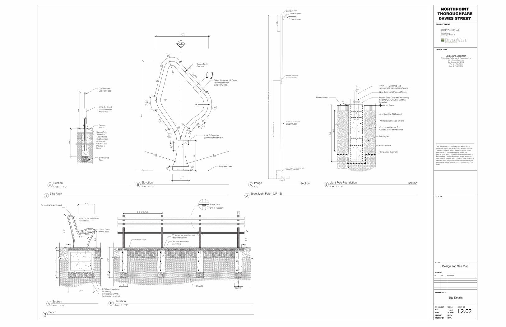
2.01 Bike RackL2.01
1
Stone Setts Pavement
2.02 Bench
Street Curb, Refer to Civil Dwgs
2.03 Street Light Pole
L2.012
L2.014
L2.015
1.05
L2.021
Roadway Pavement, Refer to to Civil Dwgs1.06
L2.023
L2.022
LANDSCAPE ARCHITECTURAL LEGEND
P.L.Property Line
Proposed Contour Line21
Bike Rack
Bench
Street Light PoleLP-S
Trench DrainTD
Accessible Curb Cut
Proposed Spot Elevation00.00
Street Signage, Refer to Civil Dwgs
PLANTING SCHEDULE
KEY TYPE QTY. SIZE ROOT NOTESCANOPY TREES
Gleditsia triacanthos 'Skyline' 5 4-4 1/2" CAL. B&B Lowest Limb @ 7'
Platanus x acerifolia 5 4-4 1/2" CAL. B&B Lowest Limb @ 7'
Celtis occidentalis 'Magnifica' 5 4-4 1/2" CAL. B&B Lowest Limb @ 7'
Acer saccharum 'Green Mountain' 5 4-4 1/2" CAL. B&B Lowest Limb @ 7'
Gymnocladus dioicus 4 4-4 1/2" CAL. B&B Lowest Limb @ 7'
PLANTING LEGEND
Canopy Tree
3.00 MISCELLANEOUS
3.01 Accessible Curb Cut
3.02 Trench Drain L2.018
3.03 Roadway Striping, Refer to Civil Dwgs
L2.016
01" = 20'10' 20' 40'
Scale:
DESIGN TEAM
This document is preliminary and describes thegeneral scope of the project, and design concept.These documents do not necessarily indicate ordescribe all of the work required for the fullperformance and completion of the requirements ofthe contract. On the basis of the scope indicated,described or inferred, the Contractor shall determineand include in the proposals all items necessary toprovide the proper execution and completion of thework.
LANDSCAPE ARCHITECTMichael Van Valkenburgh Associates, Inc.
231 Concord AvenueCambridge, MA 02138
Tel: 617.864.2076Fax: 617.492.3128
24 East StreetCambridge, MA 02141
DW NP Property, LLC
PROJECT CLIENT
NORTHPOINTTHOROUGHFAREDAWES STREET
N
L1.01
4"6"
Sawn CJ EJ
1/2" Ø x 12" Smooth S.S Dowel, GreaseOne End. Center in Broom FinishConcrete Pavement Slab. Place 12" O.C.
Material Varies, StructuralPlanting Soil or Clean Fill
3/4" Crushed Stone
VariesSee L2.00 for
Locations
10"
NOTES:1. Provide 12" Expansion Joint, Recess 34" and fill with
Backer Rod and Sealant.2. Sawcut Control Joints to be 1/4 Depth of Entire
Slab Depth.3. Contractor Shall Strictly Follow Control and
Expansion Joint Pattern Shown on the Dwgs.Review Layout with Landscape Architect andGain Final Acceptance Before Placing Concrete
4"
Graded AggregateWith Stabilizer.Place in Two EqualLifts, CompactEach Layer
Planting Soil1
L2.03
6"6"
Sawn CJ EJ
1/2" Ø x 12" Smooth S.S Dowel, GreaseOne End. Center in Broom FinishConcrete Pavement Slab. Place 12" O.C.
Material Varies, StructuralPlanting Soil or Clean Fill
3/4" Crushed Stone
VariesSee L2.00 for
Locations
1'
NOTES:1. Provide 12" Expansion Joint, Recess 34" and fill with
Backer Rod and Sealant.2. Sawcut Control Joints to be 1/4 Depth of Entire
Slab Depth.3. Contractor Shall Strictly Follow Control and
Expansion Joint Pattern Shown on the Dwgs.Review Layout with Landscape Architect andGain Final Acceptance Before Placing Concrete
4"
Exposed Aggregate Topping Layer w/1/8" to 1/2" Stone Aggregate andReinforcing Fiber.
Fiber-Reinforced CIP Concrete w/ RoughRaked Finish. Apply Bonding Agent Priorto Application of Topping Layer
Material Varies,StructuralPlanting Soil orClean Fill
Sawn CJ
34" Crushed Stone
2"
EJ
1'
NOTES:1. Provide 12" Expansion Joint, Recess 34" and fill with
Backer Rod and Sealant.2. Sawcut Control Joints to be 1/4 Depth of Entire
Slab Depth.3. Contractor Shall Strictly Follow Control and
Expansion Joint Pattern Shown on the Dwgs.Review Layout with Landscape Architect andGain Final Acceptance Before Placing Concrete
1/2"Ø x 12" Smooth S.S. Dowel Rod,Grease One End. Center in ExposedAggregate Pavement Base Slab. Placeat 12" O.C.
6"
Fiber ReinforcedCIP Concrete Base
Compacted Gravel Baseor 34" Crushed Stone
38" Joints EJ
1'-4
"
17'-0"
Detectable WarningStrip, 2 PanelsL2.01
7
Street Curb. Refer toCivil Dwgs.
Concrete Pavement -Pedestrian
L2.011
8.3%
MA
X
2'-0"
10% MAX10% MAX
Transition Curb
Flush Granite Curb
5'-0"
Detectable Warning StripPlate. Cast in Concrete
EJ
Flush Curb Granite
2'-0"Embedment Flange, 1' O.C.
1'-0"
Roadway,See Civil Dwgs
6"
4"
8.3% MAX
C.I.P. ConcreteCradle
6"6"
1:1
1:1
Compacted orUndisturbed Subgrade 6" 6" 6"
Compacted GravelBase
6"6"
6"
Material Varies. Concrete Pavement orStone Sett Pavement
L6.011
Compacted orUndisturbed Subgrade
3/4" Crushed Stone
CS 4" O.D. Aeration andInfiltration Pipe
Planting Soil
L6.015
ROAD
Drip Tubing, See IrrigationDwgs3" Sleeve, See IrrigationDwgs
CIP Conc. Cradle, See CivilDwgs
Trench Drain,See Civil Dwgs
Non-shrink Grout
6" 6" 8"
1" Mortar Setting Bed
Back of Curb,1/2" Split Variance
4"Ø HDPE Pipe90° Elbow
Street Curb, See Civil Dwgs
L2.014
Street Curb, SeeCivil Dwgs
Back of Curb,1/2" Split Variance
Planting Soil
ROAD
Formed CIP Concrete
1/2" Ø x 6" S.S. Pin, Centerin Base, Space at 12" O.C.
CIP Concrete Cradle,See Civil Dwgs
Decomposed GranitePavement
Non-shrink Grout
Trench Drain,See Civil Dwgs
1" Mortar Setting Bed
6" 6" 8"
Edge of Rootball
3" Sleeve, See Irrigation Dwgs
Drip Tubing, See Irrigation Dwgs
DESIGN TEAM
This document is preliminary and describes thegeneral scope of the project, and design concept.These documents do not necessarily indicate ordescribe all of the work required for the fullperformance and completion of the requirements ofthe contract. On the basis of the scope indicated,described or inferred, the Contractor shall determineand include in the proposals all items necessary toprovide the proper execution and completion of thework.
LANDSCAPE ARCHITECTMichael Van Valkenburgh Associates, Inc.
231 Concord AvenueCambridge, MA 02138
Tel: 617.864.2076Fax: 617.492.3128
24 East StreetCambridge, MA 02141
DW NP Property, LLC
PROJECT CLIENT
NORTHPOINTTHOROUGHFAREDAWES STREET
1Concrete Pavement - PedestrianScale: 1"= 1'-0''
Section 2Concrete Pavement - VehicularScale: 1"= 1'-0''
Section
4Decomposed Granite Pavement Scale: 1" = 1'-0''
Section
8Trench DrainScale: 1"= 1'-0''
Section
3Exposed Aggregate Concrete Pavement Scale: 1"= 1'-0''
Section
5Stone Sett Pavement Scale: 1"= 1'-0''
Section 6Accessible Curb CutScale: 1/2"= 1'-0''
Plan
7Detectable Warning StripScale: 1"= 1'-0''
Section L2.01
A Trench Drain at Pavement Scale: 1 1/2" = 1'-0" B Trench Drain at Tree Planting
Scale: 1 1/2" = 1'-0"
3'-4
"
4'-0
"
C/D
3'-4
"
R6"
101 4"
1'-2 58 "
61 2"
11"
R6"
211 16"
R9"
834
"
4 1516 "
8 38 "
318"
114"
1'-714"
5716"
R1'-35 8"
R1118"
6"
R3"
R9"
11"
38"
E
Finish: Panguard II E Coat aPowdercoat Finish.Color: RAL 7022
12"SQ.
1'-6
"
18'-0
" TO
INTE
RN
AL
DA
MP
ER
4" x 6" FLUSH TYPE REINFORCEDHANDHOLE ASSEMBLY
INTERNAL VIBRATIONDAMPER ASSEMBLY
356 CAST AL. ALLOYPOLE CAP
3'-0
"4
1/2"
O.D
.
30'-0
" PO
LE H
EIG
HT
6063-T6 AL. ALLOY SHAFT7" O.D. x .188" WALLTAPERED 7" x 4 1/2"
LUMEWAVE NODE
ARIETA FIXTURE
8'-0
"
CL
Finish Grade
1"
New Street Light Pole and Fixture
30'-0" (+/-) Light Pole andAnchoring System by Manufacturer
Provide Base Cover as Furnished byPole Manufacturer, See LightingSchedule
1'-8" Ø
Compacted Subgrade
6 - #6 Vertical, EQ Spaced
Conduit and Ground Rod,Connect to Inside Metal Pole
#4 Horizontal Ties @ 12" O.C.
Material Varies
3'-8
"
Barrier Marker
Planting Soil
DESIGN TEAM
This document is preliminary and describes thegeneral scope of the project, and design concept.These documents do not necessarily indicate ordescribe all of the work required for the fullperformance and completion of the requirements ofthe contract. On the basis of the scope indicated,described or inferred, the Contractor shall determineand include in the proposals all items necessary toprovide the proper execution and completion of thework.
LANDSCAPE ARCHITECTMichael Van Valkenburgh Associates, Inc.
231 Concord AvenueCambridge, MA 02138
Tel: 617.864.2076Fax: 617.492.3128
24 East StreetCambridge, MA 02141
DW NP Property, LLC
PROJECT CLIENT
NORTHPOINTTHOROUGHFAREDAWES STREET
1Bike Rack
ASectionScale: 1"= 1'-0''
BElevationScale: 3"= 1'-0''
L2.02
2Street Light Pole - (LP - S)
AImageNTS
Section BLight Pole FoundationScale: 1"= 1'-0''
Section
3Bench
ASectionScale: 1"= 1'-0''
BElevationScale: 1"= 1'-0''
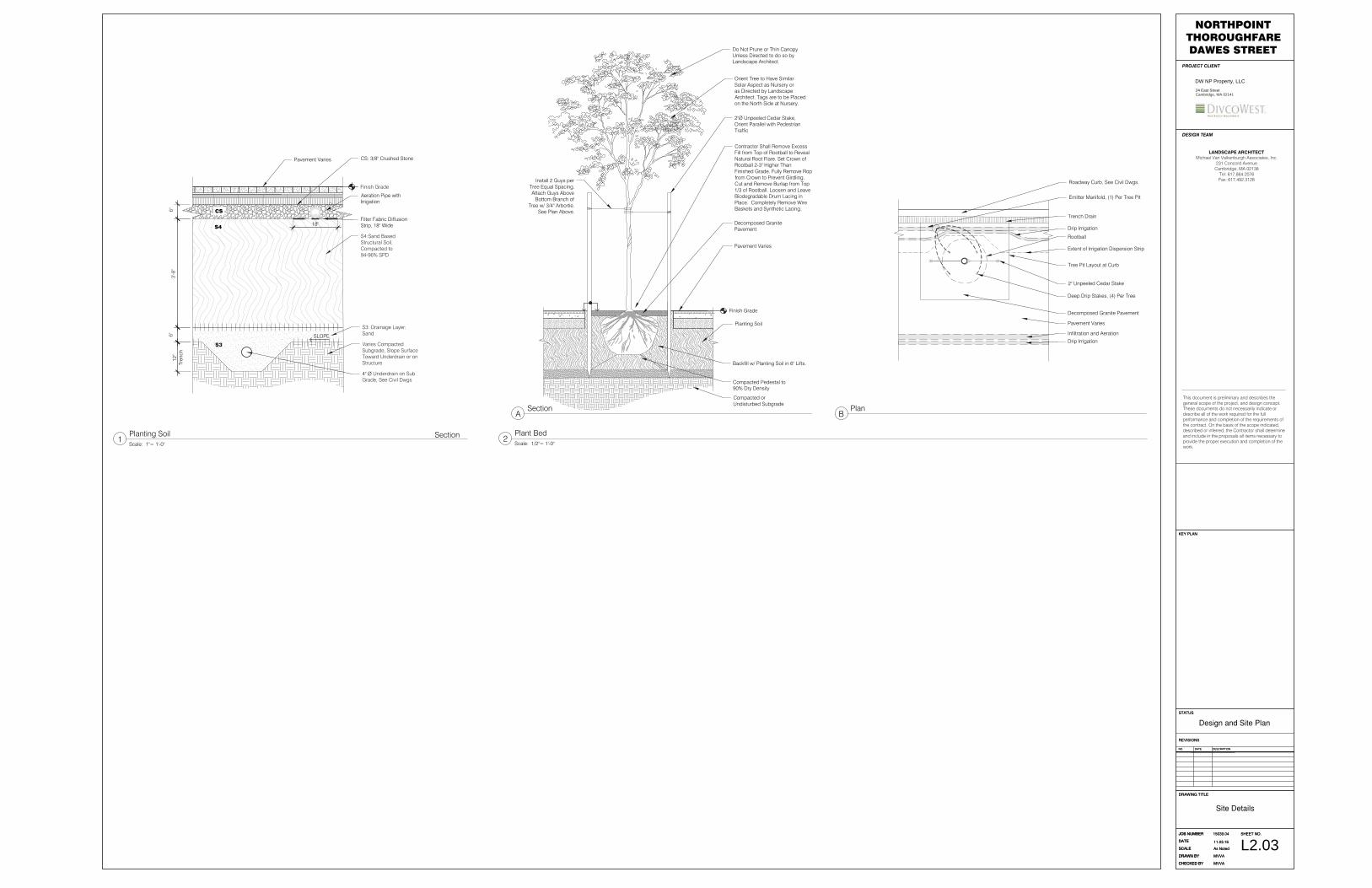
S4
S3
Pavement Varies
S4:Sand BasedStructural Soil,Compacted to94-96% SPD
S3: Drainage Layer:Sand
Varies CompactedSubgrade, Slope SurfaceToward Underdrain or onStructure
6" 3
'-8"
6"
Finish Grade
Aeration Pipe withIrrigation
SLOPE
Filter Fabric DiffusionStrip, 18" Wide18"
CS: 3/8" Crushed Stone
CS
4" Ø Underdrain on SubGrade, See Civil Dwgs
12"
Tren
ch
Finish Grade
Do Not Prune or Thin CanopyUnless Directed to do so byLandscape Architect.
Orient Tree to Have SimilarSolar Aspect as Nursery oras Directed by LandscapeArchitect. Tags are to be Placedon the North Side at Nursery.
Decomposed GranitePavement
Compacted orUndisturbed Subgrade
Pavement Varies
Contractor Shall Remove ExcessFill from Top of Rootball to RevealNatural Root Flare. Set Crown ofRootball 2-3" Higher ThanFinished Grade. Fully Remove Ropfrom Crown to Prevent Girdling.Cut and Remove Burlap from Top1/3 of Rootball. Loosen and LeaveBiodegradable Drum Lacing inPlace. Completely Remove WireBaskets and Synthetic Lacing.
Compacted Pedestal to90% Dry Density
Backfill w/ Planting Soil in 6" Lifts.
Planting Soil
2"Ø Unpeeled Cedar Stake,Orient Parallel with PedestrianTraffic
Install 2 Guys perTree Equal Spacing.Attach Guys Above
Bottom Branch ofTree w/ 3/4" Arbortie.
See Plan Above.
Roadway Curb, See Civil Dwgs.
Trench Drain
2" Unpeeled Cedar Stake
Decomposed Granite Pavement
Drip Irrigation
Infiltration and Aeration
Drip Irrigation
Emitter Manifold, (1) Per Tree Pit
Pavement Varies
Deep Drip Stakes, (4) Per Tree
Extent of Irrigation Dispersion Strip
Rootball
Tree Pit Layout at Curb
DESIGN TEAM
This document is preliminary and describes thegeneral scope of the project, and design concept.These documents do not necessarily indicate ordescribe all of the work required for the fullperformance and completion of the requirements ofthe contract. On the basis of the scope indicated,described or inferred, the Contractor shall determineand include in the proposals all items necessary toprovide the proper execution and completion of thework.
LANDSCAPE ARCHITECTMichael Van Valkenburgh Associates, Inc.
231 Concord AvenueCambridge, MA 02138
Tel: 617.864.2076Fax: 617.492.3128
24 East StreetCambridge, MA 02141
DW NP Property, LLC
PROJECT CLIENT
NORTHPOINTTHOROUGHFAREDAWES STREET
1Planting SoilScale: 1"= 1'-0''
Section
ASection
BPlan
2Plant BedScale: 1/2"= 1'-0''
L2.03

MORIARTYNorthpoint Logistics Plan
Overall Site PlanAugust 19, 2016
LEGEND
STOCKING OF GRANITE BLOCKSMBTA PARKING &CONSTRUCTION EASEMENTSHAWMUT PARCEL
JMA PARCEL
TBD PARCEL
TISHMAN PARCEL
LANDSCAPING/PARKS
JMA FIRST AID TRAILER
SLOPED GRADE
TRAFFIC IN
TRAFFIC OUT
HAUL ROAD
35'
10'
15'
15'
35'
DIVCO WEST MARKETINGTRAILER
0'
STOCKING OF GRANITE BLOCKS
A
B
C
D
I
J/K
EF
W
Q1
Q2
LM
G
H
JMA FIRST AID TRAILER
LAY DOWN AREA FOR PARCEL JK WITH ON-SITE CONSTRUCTION PARKING
I SOUTH
SHAWMUT PARCELS
DIVCO WEST MARKETING TRAILER
U
LAY DOWN AREA FOR PARCEL L/M WITH ON-SITE CONSTRUCTION PARKING
LAY DOWN AREA FOR SITEWORK
AREA OF PARK TO BE BUILT WITH EF
RESERVED FOR MBTA PARKING
HAUL ROAD
MONSIGNOR O’BRIEN HWY
MUSE
UM W
AY
CHAR
LEST
OWN
AVE.
GILM
ORE
BRID
GE
EDUC
ATIO
N ST
REET
TRAF
FIC
IN (O
VER
BRID
GE)
TRAFFIC OUT (OVER BRIDGE)
TRAFFIC IN
TRAFFIC OUT
GRANITE STOCK PILE
OIL/WATER SEPARATOR
10’X40’TRAILER10’X40’ TRAILER
IN IN
OUT
OUT
INOUT
IN
OUT
IN
OUT
IN
OUT
20’X40’ TRAILER
10’X40’ TRAILER
10’X40’ TRAILER
IN
OUT
PROPOSED EVERSOURCE TEMP ELECTRIC
LAY DOWN AREA FOR PARCEL I WITH ON-SITE CONSTRUCTION PARKING
R1
AREA OF PARK TO BE BUILT WITH JK
AREA OF PARK TO BE REBUILT WITH W