panoptic segmentation of satellite image time series with
TRANSCRIPT

Panoptic Segmentation of Satellite Image Time Serieswith Convolutional Temporal Attention Networks
Vivien Sainte Fare Garnot Loic LandrieuLASTIG, Univ. Gustave Eiffel, ENSG, IGN, F-94160 Saint-Mande, France
{vivien.sainte-fare-garnot, loic.landrieu}@ign.fr
Abstract
Unprecedented access to multi-temporal satellite im-agery has opened new perspectives for a variety of Earthobservation tasks. Among them, pixel-precise panoptic seg-mentation of agricultural parcels has major economic andenvironmental implications. While researchers have ex-plored this problem for single images, we argue that thecomplex temporal patterns of crop phenology are better ad-dressed with temporal sequences of images. In this pa-per, we present the first end-to-end, single-stage methodfor panoptic segmentation of Satellite Image Time Series(SITS). This module can be combined with our novel imagesequence encoding network which relies on temporal self-attention to extract rich and adaptive multi-scale spatio-temporal features. We also introduce PASTIS, the first open-access SITS dataset with panoptic annotations. We demon-strate the superiority of our encoder for semantic segmen-tation against multiple competing architectures, and set upthe first state-of-the-art of panoptic segmentation of SITS.Our implementation and PASTIS are publicly available.
1. Introduction
The precision and availability of Earth observations havecontinuously improved thanks to sustained advances inspace-based remote sensing, such as the launch of the Planet[5] and the open-access Sentinel constellations [8]. In par-ticular, satellites with high revisit frequency contribute to abetter understanding of phenomena with complex temporaldynamics. Crop mapping—the driving application of thispaper—relies on exploiting such temporal patterns [37] andentails major financial and environmental stakes. Indeed,remote monitoring of the surface and nature of agriculturalparcels is necessary for a fair allocation of agricultural sub-sidies (50 and 22 billion euros per year in Europe and inthe US, respectively) and for ensuring that best crop rota-tion practices are respected. More generally, the automatedanalysis of SITS represents a significant interest for a wide
Figure 1: Overview. We propose an end-to-end, single-stage model for panoptic segmentation of agriculturalparcels from time series of satellite images. Note the diffi-culty of resolving the parcels’ borders from a single image,highlighting the need for modeling temporal dynamics.
range of applications, such as surveying urban developmentand deforestation.
The task of monitoring both the content and extent ofagricultural parcels can be framed as the panoptic segmen-tation of an image sequence. Panoptic segmentation con-sists of assigning to each pixel a class and a unique instancelabel, and has become a standard visual perception task incomputer vision [18, 25]. However, panoptic segmentationis a fundamentally different task for SITS versus sequencesof natural images or videos. Indeed, understanding videosrequires tracking objects through time and space [43]. Inyearly SITS, the targets are static in a geo-referenced frame,which removes the need for spatial tracking. Additionally,SITS share a common temporal frame of reference, whichmeans that the time of acquisition itself contains informa-tion useful for modeling the underlying temporal dynamics.In contrast, the frame number in videos is often arbitrary.Finally, while objects on the Earth surface generally do notocclude one another, as is commonly the case for objects innatural images, varying cloud cover can make the analysisof SITS arduous. For the specific problem addressed in this
4872

paper, individualizing agricultural parcels requires learningcomplex and specific temporal, spatial, and spectral patternsnot commonly encountered in video processing, such as dif-ferences in plant phenological profiles, subpixel border in-formation, and swift human interventions such as harvests.
While deep networks have proven efficient for learningsuch complex patterns for pixel classification [16, 12, 1],there is no dedicated approach for detecting individual ob-jects in SITS. Existing work on instance segmentation hasbeen restricted to analysing a single satellite image [32]. Insummary, specialized remote sensing methods are limitedto semantic segmentation or single-image instance segmen-tation, while computer vision’s panoptic-ready networks re-quire significant adaptation to be applied to SITS.
In this paper, we introduce U-TAE (U-net with TemporalAttention Encoder), a novel spatio-temporal encoder com-bining multi-scale spatial convolutions [33] and a tempo-ral self-attention mechanism [37] which learns to focus onthe most salient acquisitions. While convolutional-recurrentmethods are limited to extracting temporal features at thehighest [34] or lowest [36] spatial resolutions, our proposedmethod can use the predicted temporal masks to extract spe-cialized and adaptive spatio-temporal features at differentresolutions simultaneously. We also propose Parcels-as-Points (PaPs), the first end-to-end deep learning method forpanoptic segmentation of SITS. Our approach is built uponthe efficient CenterMask network [48], which we modifyto fit our problem. Lastly, we present Panoptic Agricul-tural Satellite TIme-Series (PASTIS), the first open-accessdataset for training and evaluating panoptic segmentationmodels on SITS, with over 2 billion annotated pixels cover-ing over 4000km2. Evaluated on this dataset, our approachoutperforms all reimplemented competing methods for se-mantic segmentation, and defines the first state-of-the-art ofSITS panoptic segmentation.
2. Related Work
To the best of our knowledge, no instance or panopticsegmentation method operating on SITS has been proposedto date. However, there is a large body of work on both theencoding of satellite sequences, and the panoptic segmenta-tion of videos and single satellite images.
Encoding Satellite Image Sequences. While the first au-tomated tools for SITS analysis relied on traditional ma-chine learning [13, 45], deep convolutional networks allowfor the extraction of richer spatial descriptors [19, 12, 1, 16].The temporal dimension was initially dealt via handcraftedtemporal descriptors [2, 42, 51] or probabilistic models[3], which have been advantageously replaced by recurrent[34, 37, 27], convolutional [29, 36, 15], or differential [24]architectures. Recently, attention-based approaches have
been adapted to encode sequences of remote sensing im-ages and have led to significant progress for pixel-wise andparcel-wise classification [38, 35, 53]. In parallel, hybridarchitectures [41, 36, 28] relying on U-Net-type architec-tures [33] for encoding the spatial dimension and recurrentnetworks for the temporal dimension have shown to be wellsuited for the semantic segmentation of SITS. In this pa-per, we propose to combine this hybrid architecture withthe promising temporal attention mechanism.
Instance Segmentation of Satellite Images. The firststep of panoptic segmentation is to delineate all individualinstances, i.e. instance segmentation. Most remote sens-ing instanciation approaches operate on a single acquisition.For example, several methods have been proposed to de-tect individual instances of trees [31, 54], buildings [46], orfields [32]. Several algorithms start with a delineation step(border detection) [9, 23, 47], and require postprocessing toobtain individual instances. Other methods use segmenta-tion as a preprocessing step and compute cluster-based fea-tures [6, 7], but do not produce explicit cluster-to-objectmappings. Petitjean et al. [30] propose a segmentation-aided classification method operating on image time series.However, their approach partitions each image separatelyand does not attempt to retrieve individual objects consis-tently across the entire sequence. In this paper, we proposethe first end-to-end framework for directly performing jointsemantic and instance segmentation on SITS.
Panoptic Segmentation of Videos. Among the vast lit-erature on instance segmentation, Mask-RCNN [11] is theleading method for natural images. Recently, Wang et al.proposed CenterMask [48], a lighter and more efficientsingle-stage method which we use as a starting point inthis paper. Several approaches propose extending instanceor panoptic segmentation methods from image to video[50, 43, 17]. However, as explained in the introduction,SITS differs from natural video in several key ways whichrequire specific algorithmic and architectural adaptations.
3. MethodWe consider an image time sequence X , organized into
a four-dimensional tensor of shape T ×C×H×W , with Tthe length of the sequence, C the number of channels, andH ×W the spatial extent.
3.1. Spatio-Temporal Encoding
Our model, dubbed U-TAE (U-Net with Temporal At-tention Encoder), encodes a sequence X in three steps: (a)each image in the sequence is embedded simultaneouslyand independently by a shared multi-level spatial convolu-tional encoder, (b) a temporal attention encoder collapses
4873

Conv Block
Conv Block
Conv Block
Conv Block
Temporal Attention
Conv 1x1
Conv Block
Conv Block
Conv 1x1
Conv Block
Conv 1x1
Conv 1x1
(×2)
(×4)Blockwise temporal weighted sum
Up-convolution
Down-convolution
Feature map sequence
Feature map
Attention masks
(×2) Upsampling
T × C1 × H × W C1 × H × W
D4 × H8 × W
8
D3 × H4 × W
4
D2 × H2 × W
2
D1 × H × W
Attention masks
d4
d3
d2
d1
T
e3
e2
e1
(×8)
Figure 2: Spatio-temporal Encoding. A sequence of images is processed in parallel by a shared convolutional encoder. Atthe lowest resolution, an attention-based temporal encoder produces a set of temporal attention masks for each pixel, whichare then spatially interpolated at all resolutions. These masks are used to collapse the temporal dimension of the featuremap sequences into a single map per resolution. A convolutional decoder then computes features at all resolution levels. Allconvolutions operate purely on the spatial and channel dimensions, and we use strided convolutions for both spatial up anddown-sampling. The feature maps are projected in RGB space to help visual interpretation.
the temporal dimension of the resulting sequence of featuremaps into a single map for each level, (c) a spatial convolu-tional decoder produces a single feature map with the sameresolution as the input images, see Figure 2.
a) Spatial Encoding. We consider a convolutional en-coder E with L levels 1, · · · , L. Each level is composed ofa sequence of convolutions, Rectified Linear Unit (ReLu)activations, and normalizations. Except for the first level,each block starts with a strided convolution, dividing theresolution of the feature maps by a factor 2.
For each time stamp t simultaneously, the encoder El atlevel l takes as input the feature map of the previous levelel−1t , and outputs a feature map elt of size Cl × Hl × Wl
with Hl = H/2l−1 and Wl = W/2l−1. The resulting fea-ture maps are then temporally stacked into a feature mapsequence el of size T × Cl ×Hl ×Wl:
el = [El(el−1t )]Tt=0 for l ∈ [1, L] , (1)
with e0 = X and [ · ] the concatenation operator along thetemporal dimension. When constituting batches, we flattenthe temporal and batch dimensions. Since each sequencecomprises images acquired at different times, the batches’samples are not identically distributed. To address this is-sue, we use Group Normalization [49] with 4 groups insteadof Batch Normalization [14] in the encoder.
b) Temporal Encoding. In order to obtain a single rep-resentation per sequence, we need to collapse the tempo-ral dimension of each feature map sequence el before usingthem as skip connections. Convolutional-recurrent U-Netnetworks [41, 36, 28] only process the temporal dimensionof the lowest resolution feature map with a temporal en-coder. The rest of the skip connections are collapsed witha simple temporal average. This prevents the extraction ofspatially adaptive and parcel-specific temporal patterns athigher resolutions. Conversely, processing the highest res-olution would result in small spatial receptive fields for thetemporal encoder, and an increased memory requirement.Instead, we propose an attention-based scheme which onlyprocesses the temporal dimension at the lowest feature mapresolution, but is able to utilize the predicted temporal at-tention masks at all resolutions simultaneously.
Based on its performance and computational efficiency,we choose the Lightweight-Temporal Attention Encoder(L-TAE) [10] to handle the temporal dimension. The L-TAE is a simplified multi-head self-attention network [44]in which the attention masks are directly applied to the in-put sequence of vectors instead of predicted values. Addi-tionally, the L-TAE implements a channel grouping strategysimilar to Group Normalization [49].
We apply a shared L-TAE with G heads independentlyat each pixel of eL, the feature map sequence at the low-est level resolution L. This generates G temporal attentionmasks for each pixel, which can be arranged into G tensors
4874
aL,g with values in [0, 1] and of shape T ×HL ×WL:
aL,1, · · · , aL,G = LTAE(eL) , applied pixelwise. (2)
In order to use these attention masks at all scale levels l ofthe encoder, we compute spatially-interpolated masks al,g
of shape T ×Hl ×Wl for all l in [1, L− 1] and g in [1, G]with bilinear interpolation:
al,g = resize aL,g to Hl ×Wl . (3)
The interpolated masks al,g at level l of the encoder arethen used as if they were generated by a temporal atten-tion module operating at this resolution. We apply theL-TAE channel-grouping strategy at all resolution levels:the channels of each feature map sequence el are splitinto G contiguous groups el,1, · · · , el,G of identical shapeT×Cl/G×Wl×Hl. For each group g, the feature map se-quence el,g is averaged on the spatial dimension using al,g
as weights. The resulting maps are concatenated along thechannel dimension, and processed by a shared 1 × 1 con-volution layer Convl
1×1 of width Cl. We denote by f l theresulting map of size Cl ×Wl ×Hl by :
f l = Convl1×1
[T∑
t=1
al,gt ⊙ el,gt
]G
g=1
, (4)
with [ · ] the concatenation along the channel dimension and⊙ the term-wise multiplication with channel broadcasting.
c) Spatial Decoding. We combine the feature maps f l
learned at the previous step with a convolutional decoderto obtain spatio-temporal features at all resolutions. Thedecoder is composed of L − 1 blocks Dl for 1 ≤ l < L,with convolutions, ReLu activations, and BatchNorms [14].Each decoder block uses a strided transposed convolutionDup
l to up-sample the previous feature map. The decoder atlevel l produces a feature map dl of size Dl×Hl×Wl. In aU-Net fashion, the encoder’s map at level l is concatenatedwith the output of the decoder block at level l − 1:
dl = Dl([Dupl (dl+1), f l]) for l ∈ [1, L− 1] , (5)
with dL = fL and [ · ] is the channelwise concatenation.
3.2. Panoptic Segmentation
Our goal is to use the multi-scale feature maps {dl}Ll=1
learnt by the spatio-temporal encoder to perform panop-tic segmentation of a sequence of satellite images over anarea of interest. The first stage of panoptic segmentationis to produce instance proposals, which are then combinedinto a single panoptic instance map. Since an entire se-quence of images (often over 50) must be encoded to com-pute {dl}Ll=1, we favor a simple approach for our panop-tic segmentation module. Furthermore, given the relative
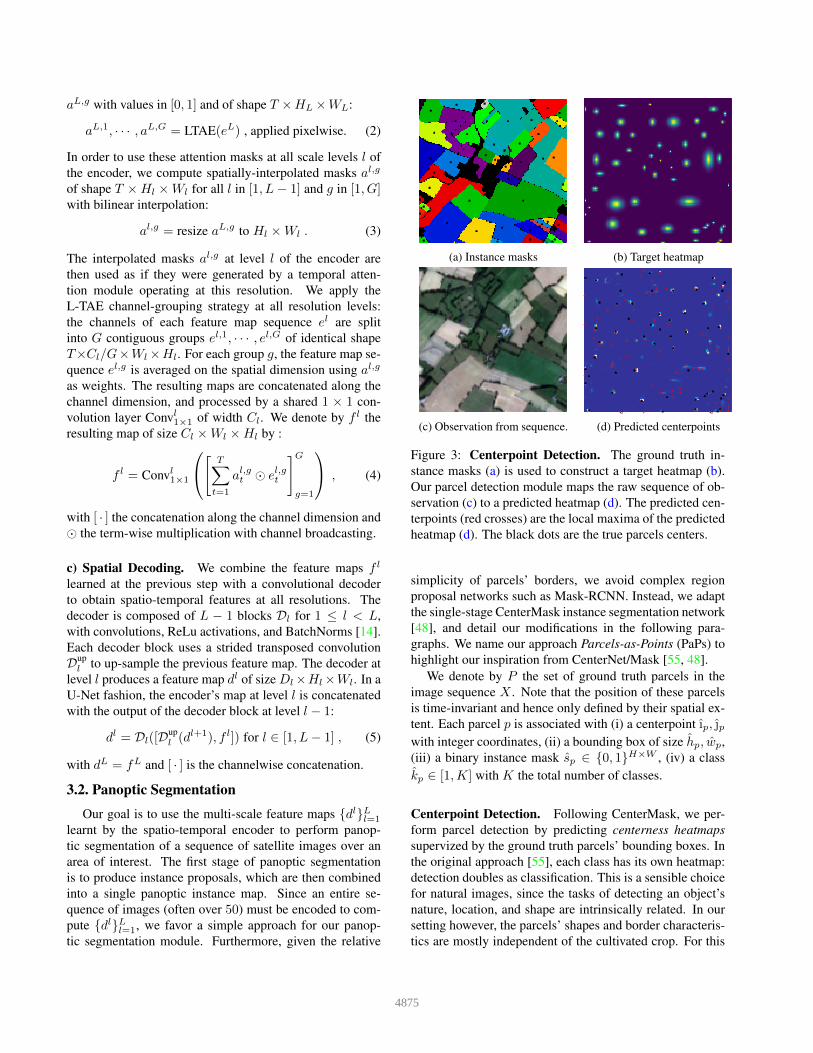
(a) Instance masks (b) Target heatmap
(c) Observation from sequence. (d) Predicted centerpoints
Figure 3: Centerpoint Detection. The ground truth in-stance masks (a) is used to construct a target heatmap (b).Our parcel detection module maps the raw sequence of ob-servation (c) to a predicted heatmap (d). The predicted cen-terpoints (red crosses) are the local maxima of the predictedheatmap (d). The black dots are the true parcels centers.
simplicity of parcels’ borders, we avoid complex regionproposal networks such as Mask-RCNN. Instead, we adaptthe single-stage CenterMask instance segmentation network[48], and detail our modifications in the following para-graphs. We name our approach Parcels-as-Points (PaPs) tohighlight our inspiration from CenterNet/Mask [55, 48].
We denote by P the set of ground truth parcels in theimage sequence X . Note that the position of these parcelsis time-invariant and hence only defined by their spatial ex-tent. Each parcel p is associated with (i) a centerpoint ıp, ȷpwith integer coordinates, (ii) a bounding box of size hp, wp,(iii) a binary instance mask sp ∈ {0, 1}H×W , (iv) a classkp ∈ [1,K] with K the total number of classes.
Centerpoint Detection. Following CenterMask, we per-form parcel detection by predicting centerness heatmapssupervized by the ground truth parcels’ bounding boxes. Inthe original approach [55], each class has its own heatmap:detection doubles as classification. This is a sensible choicefor natural images, since the tasks of detecting an object’snature, location, and shape are intrinsically related. In oursetting however, the parcels’ shapes and border characteris-tics are mostly independent of the cultivated crop. For this
4875

Conv
Conv
local maxima
(D1 + D2 + D3 + D4) × H × W
MLP
Centerness heatmap
Saliency
Detectedcenters
Shape patchM
Select
Reshape
Multi-scale descriptorsResized shape
Cropped saliency
Predictedbinarymask
Sizewchc
Threshold
Classkc
Conv
S × Shc × wc
M ×
Figure 4: Panoptic Segmentation. The local maxima of the predicted centerness heatmap defines M tentative parcels. Foreach one, the pixel features at all levels are concatenated and used to predict a bounding box size, a semantic class, andan S × S shape patch. The latter is combined with a global saliency map for predicting pixel-precise masks. The instancepredictions are combined into a panoptic segmentation using the centerness as quality.
reason, we use a single centerness heatmap and postponeclass identification to a subsequent specialized module. SeeFigure 3 for an illustration of our parcel detection method.
We associate each parcel p with a Gaussian kernel ofdeviations σver
p and σhorp taken respectively as 1/20 of the
height and width of the parcels’ bounding box. Unlike Lawand Deng [20], we use heteroschedastic kernels to reflectthe potential narrowness of parcels. We then define the tar-get centerness heatmap m ∈ [0, 1]H×W as the maximumvalue of all parcel kernels at each pixel (i, j) in H × W :
mi,j = maxp∈P
exp
(−[(i− ıp)
2
2(σverp )2
+(j − ȷp)
2
2(σhorp )2
])(6)
A convolutional layer takes the highest-resolution featuremap d1 as input and predicts a centerness heatmap m ∈[0, 1]H×W . The predicted heatmap is supervized using theloss defined in Equation 7 with β = 4:
Lcenter=−1
|P |∑
i=1···Hj=1···W
{log(mi,j) if mi,j = 1
(1−mi,j)β log(1−mi,j) else.
(7)
We define the predicted centerpoints as the local maximaof m, i.e. pixels with larger values than their 8 adjacentneighbors. This set can be efficiently computed with a sin-gle max-pooling operation. Replacing the max operator byargmax in Equation 6 defines a mapping H × W 7→ Pbetween pixels and parcels. During training, we associateeach true parcel p with the predicted centerpoint c(p) withhighest predicted centerness m among the set of center-points which coordinates are mapped to p. If this set is
empty, then c(p) is undefined: the parcel p is not detected.We denote by P ′ the subset of detected parcels, i.e. forwhich c(p) is well defined.
Size and Class Prediction. We associate to a predictedcenterpoint c of coordinate (ic, jc) the multi-scale featurevector dc of size D1 + · · · + DL by concatenating chan-nelwise the pixel features at location (ic, jc) in all maps dl:
dc =[dl(⌊ic/2
l−1⌋,⌊jc/2
l−1⌋)]L
l=1, (8)
with [ · ] the channelwise concatenation. This vector dcis then processed by four different multilayer perceptrons(MLP) to obtain three vectors of sizes 2, K, and S2 repre-senting respectively: (i) a bounding box size hc, wc, (ii) avector of class probabilities kc of size K, and (iii) a shapepatch sc of fixed size S × S. The latter is described in thenext paragraph.
The class prediction kc(p) associated to the true parcel pis supervized with the cross-entropy loss, and the size pre-diction with a normalized L1 loss. For all p in P ′, we have:
Lpclass = − log(kc(p)[kp]) (9)
Lpsize=
|hc(p) − hp|hp
+|wc(p) − wp|
wp. (10)
Shape Prediction. The idea of this step is to combine fora predicted centerpoint c a rough shape patch sc with a full-resolution global saliency map z to obtain a pixel-precise
4876

instance mask, see Figure 4. For a centerpoint c of coordi-nates (ic, jc), the predicted shape patch sc of size S × S isresized to the predicted size ⌈hc⌉×⌈wc⌉ with bilinear inter-polation. A convolutional layer maps the outermost featuremap d1 to a saliency map z of size H ×W , which is sharedby all predicted parcels. This saliency map is then croppedalong the predicted bounding box (ic, jc, ⌈hc⌉, ⌈wc⌉). Theresized shape and the cropped saliency are added (11) to ob-tain a first local shape lc, which is then further refined witha residual convolutional network CNN (12). We denote theresulting predicted shape by lc:
lc = resizec(sc) + cropc(z) (11)
lc = sigmoid(lc + CNN(lc)) , (12)
with resizec and cropc defined by the coordinates (ic, jc)and predicted bounding box size (⌈hc⌉, ⌈wc⌉). The shapeand saliency predictions are supervized for each parcel p inP ′ by computing the pixelwise binary cross-entropy (BCE)between the predicted shape lc(p) and the correspondingtrue binary instance mask sp cropped along the predictedbounding box (ic(p), jc(p), ⌈hc(p)⌉, ⌈wc(p)⌉):
Lpshape = BCE(lc(p), cropc(p)(sp)) . (13)
For inference, we associate a binary mask with a predictedcenterpoint c by thresholding lc with the value 0.4.
Loss Function : These four losses are combined into asingle loss with no weight and optimized end-to-end:
L = Lcenter +1
|P ′|∑p∈P ′
(Lp
class + Lpsize + Lp
shape
). (14)
Differences with CenterMask. Our approach differsfrom CenterMask in several key ways: (i) We compute asingle saliency map and heatmap instead of K differentones. This represents the absence of parcel occlusion andthe similarity of their shapes. (ii) Accounting for the lowerresolution of satellite images, centerpoints are computed atfull resolution to detect potentially small parcels, thus dis-pensing us from predicting offsets. (iii) The class predictionis handled centerpoint-wise instead of pixel-wise for effi-ciency. (iv) Only the selected centerpoints predict shape,class, and size vectors, saving computation and memory.(v) We use simple feature concatenation to compute multi-scale descriptors instead of deep layer aggregation [52] orstacked Hourglass-Networks [26]. (vi) A convolutional net-work learns to combine the saliency and the mask insteadof a simple term-wise product.
Converting to Panoptic Segmentation Panoptic seg-mentation consists of associating to each pixel a semantic
label and, for non-background pixels (our only stuff class),an instance label [18]. Our predicted binary instance maskscan have overlaps, which we resolve by associating to eachpredicted parcel a quality measure equal to the predictedcenterness m at its associated centerpoint. Masks withhigher quality overtake the pixels of overlapping masks withlesser predicted quality. If a mask loses more than 50% ofits pixels through this process, it is removed altogether fromthe predicted instances. Predicted parcels with a quality un-der a given threshold are dropped. This threshold can betuned on a validation set to maximize the parcel detectionF-score. All pixels not associated with a parcel mask arelabelled as background.
Implementation Details. Our implementation of U-TAEallows for batch training on sequences of variable lengththanks to a simple padding strategy. The complete con-figuration and training details can be found in the Ap-pendix. A Pytorch implementation is available at https://github.com/VSainteuf/utae-paps.
4. Experiments4.1. The PASTIS Dataset
We present PASTIS (Panoptic Agricultural SatelliteTIme Series), the first large-scale, publicly available SITSdataset with both semantic and panoptic annotations. Thisdataset, as well as more information about its composi-tion, are publicly available at https://github.com/VSainteuf/pastis-benchmark .
Description. PASTIS is comprised of 2 433 sequences ofmulti-spectral images of shape 10 × 128 × 128. Each se-quence contains between 38 and 61 observations taken be-tween September 2018 and November 2019, for a total ofover 2 billion pixels. The time between acquisitions isuneven with a median of 5 days. This lack of regularityis due to the automatic filtering of acquisitions with ex-tensive cloud cover by the satellite data provider THEIA.The 10 channels correspond to the non-atmospheric spectralbands of the Sentinel-2 satellite, after atmospheric correc-tion and re-sampling at a spatial resolution of 10 meters perpixel. The dataset spans over 4000 km2, with images takenfrom four different regions of France with diverse climatesand crop distributions, covering almost 1% of the FrenchMetropolitan territory. We estimate that close to 28% ofimages have at least partial cloud cover.
Annotation. Each pixel of PASTIS is associated with asemantic label taken from a nomenclature of 18 crop typesplus a background class. As is common in remote sensingapplications, the dataset is highly unbalanced, with a ra-tio of over 50 between the most and least common classes.
4877

(a) Image from the sequence. (b) Panoptic annotation. (c) Panoptic segmentation. (d) Semantic segmentation.
Figure 5: Qualitative results. We consider an image sequence (a) with panoptic annotations (b). We represent the results ofour method in terms of panoptic segmentation (c) and semantic segmentation (d). The parcels’ and pixels’ color correspondsto the crop type, according to a legend given in the appendix. The predominantly correct class predictions highlight the factthat the difficulty of panoptic segmentation lies in the precise delineation of each individual parcel. We observe cases wherethe temporal structure of the SITS was successfully leveraged to resolve boundary ambiguities that could not be seen from asingle image (cyan circle ). Conversely, some visually fragmented parcels are annotated as a single instance (red circle ).
Each non-background pixel also has a unique instance la-bel corresponding to its parcel index. In total, 124 422parcels are individualized, each with their bounding box,pixel-precise mask, and crop type. All annotations are takenfrom the publicly available French Land Parcel Identifica-tion System. The French Payment Agency estimates the ac-curacy of the crop annotations via in situ control over 98%and the relative error in terms of surfaces under 0.3%. Toallow for cross-validation, the dataset is split into 5 folds,chosen with a 1km buffer between images to avoid cross-fold contamination.
4.2. Semantic Segmentation
Our U-TAE has L = 4 resolution levels and a LTAEwith G = 16 heads, see appendix for an exact configuration.For the semantic segmentation task, the feature map d1 withhighest resolution is set to have K channels, with K thenumber of classes. We can then interpret d1 as pixel-wisepredictions to be supervized with the cross-entropy loss. Inthis setting, we do not use the PaPs module.
Competing Methods. We reimplemented six of the top-performing SITS encoders proposed in the literature:
• ConvLSTM [34, 39] and ConvGRU[4]. These ap-proaches are recurrent neural networks in which all lin-ear layers are replaced by spatial convolutions.
• U-ConvLSTM [36] and U-BiConvLSTM [22]. To repro-duce these UNet-Based architectures, we replaced theL-TAE in our architecture by either a convLSTM [40] ora bidirectional convLSTM. Skip connections are tempo-rally averaged. In contrast to the original methods, wereplaced the batch normalization in the encoders with
Table 1: Semantic Segmentation. We report for ourmethod and six competing methods the model size in train-able parameters, Overall Accuracy (OA), mean Intersectionover Union (mIoU), and Inference Time for one fold of∼ 490 sequences (IT). The second part of the table reportresults from our ablation study.
Model # param OA mIoU IT (s)×1000
U-TAE (ours) 1 087 83.2 63.1 25.73D-Unet [36] 1 554 81.3 58.4 29.5U-ConvLSTM [36] 1 508 82.1 57.8 28.3FPN-ConvLSTM [22] 1 261 81.6 57.1 103.6U-BiConvLSTM [22] 1 434 81.8 55.9 32.7ConvGRU [4] 1 040 79.8 54.2 49.0ConvLSTM [34, 39] 1 010 77.9 49.1 49.1
Mean Attention 1 087 82.8 60.1 24.8Skip Mean + Conv 1 087 82.4 58.9 24.5Skip Mean 1 074 82.0 58.3 24.5BatchNorm 1 087 71.9 36.0 22.3Single Date (August) 1 004 65.6 28.3 1.3Single Date (May) 1 004 58.1 20.6 1.3
group normalization which significantly improved theresults across-the-board.
• 3D-Unet [36]. A U-Net in which the convolutions of theencoding branch are three-dimensional to handle simul-taneously the spatial and temporal dimensions.
• FPN-ConvLSTM [22]. This model combines a featurepyramid network [21] to extract spatial features and abidirectional ConvLSTM for the temporal dimension.
4878

Analysis. In Table 1, we detail the performance obtainedwith 5-fold cross validation of our approach and the sixreimplemented baselines. We report the Overall Accuracy(OA) as the ratio between correct and total predictions,and (mIoU) the class-averaged classification IoU. We ob-serve that the convolutional-recurrent methods ConvGRUand ConvLSTM perform worse. Recurrent networks em-bedded in an U-Net or a FPN share similar performance,with a much longer inference time for FPN. Our approachsignificantly outperforms all other methods in terms of pre-cision. In Figure 5, we present a qualitative illustration ofthe semantic segmentation results.
Ablation Study. We first study the impact of using spa-tially interpolated attention masks to collapse the tempo-ral dimension of the spatio-temporal feature maps at dif-ferent levels of the encoder simultaneously. Simply com-puting the temporal average of skip connections for levelswithout temporal encoding as proposed by [41, 36], we ob-serve a drop of 4.8 mIoU points (Skip Mean). This puts ourmethod performance on par with its competing approaches.Adding a 1 × 1 convolutional layer after the temporal av-erage reduces this drop to 4.2 points (Skip Mean + Conv).Lastly, using interpolated masks but foregoing the channelgrouping strategy by averaging the masks group-wise into asingle attention mask per level results in a drop of 3.1 points(Mean Attention). This implies that our network is able touse the grouping scheme at different resolutions simultane-ously. In conclusion, the main advantage of our proposedattention scheme is that the temporal collapse is controlledat all resolutions, in contrast to recurrent methods.
Using batch normalization in the encoder leads to a se-vere degradation of the performance of 27.1 points (Batch-Norm). We conclude that the temporal diversity of theacquisitions requires special considerations. This was ob-served for all U-Net models alike. We also train our modelon a single acquisition date (with a classic U-Net and notemporal encoding) for two different cloudless dates in Au-gust and May (Single Date). We observe a drop of 24.8 and42.5 points respectively, highlighting the crucial importanceof the temporal dimension for crop classification. We alsoobserved that images with at least partial cloud cover re-ceived on average 58% less attention than their cloud-freecounterparts. This suggests that our model is able to use theattention module to automatically filter out corrupted data.
4.3. Panoptic Segmentation
We use the same U-TAE configuration for panoptic seg-mentation, and select a PaPs module with 190k parametersand a shape patch size of 16 × 16. In Table 2, we reportthe class-averaged Segmentation Quality (SQ), RecognitionQuality (RQ), and Panoptic Quality (PQ) [18]. We observethat while the network is able to correctly detect and clas-
Table 2: Panoptic Segmentation Experiment. We reportclass-averaged panoptic metrics: SQ, RQ, PQ.
SQ RQ PQ
U-TAE + PaPs 81.3 49.2 40.4U-ConvLSTM + Paps 80.9 40.8 33.4
S = 24 81.3 48.5 39.9S = 8 81.0 48.6 39.8Multiplicative Saliency 74.5 47.2 35.5Single-image 72.3 16.9 12.4
sify most parcels, the task remains difficult. In particular,the combination of ambiguous borders and hard-to-classifyparcel content makes for a challenging panoptic segmenta-tion problem. We illustrate these difficulties in Figure 5,along with qualitative results.
Replacing the temporal encoder by a U-BiConvLSTM asdescribed in Section 4.2 (U-BiConvLSTM+PaPs), we ob-serve a noticeable performance drop of 8.4 RQ, which isconsistent with the results of Table 1. As expected, ourmodel’s performance is not sensitive to changes in the sizeS of the shape patch. Indeed, the shape patches only de-termine the rough outline of parcels while the pixel-preciseinstance masks are derived from the saliency map. Perform-ing shape prediction with a simple element-wise multiplica-tion as in [48] (Multiplicative Saliency) instead of our resid-ual CNN results in a drop of over −6.8 SQ. Using a sin-gle image (August) leads to a low panoptic quality. Indeed,identifying crop types and parcel borders from a single im-age at the resolution of Sentinel-2 is particularly difficult.
Inference on 490 sequences takes 129s: 26s to generateU-TAE embeddings, 1s for the heatmap and saliency, 90sfor instance proposals, and 12s to merge them into a panop-tic segmentation. Note that the training time is also doubledcompared to simple semantic segmentation.
5. Conclusion
We introduced U-TAE, a novel spatio-temporal encoderusing a combination of spatial convolution and temporal at-tention. This model can be easily combined with PaPs, thefirst panoptic segmentation framework operating on SITS.Lastly, we presented PASTIS, the first large-scale panoptic-ready SITS dataset. Evaluated on this dataset, our approachsignificantly outperformed all other approaches for seman-tic segmentation, and set up the first state-of-the-art forpanoptic segmentation of satellite image sequences.
We hope that the combination of our open-access datasetand promising results will encourage both remote sensingand computer vision communities to consider the challeng-ing problem of panoptic SITS segmentation, whose eco-nomic and environmental stakes can not be understated.
4879

References[1] Nicolas Audebert, Bertrand Le Saux, and Sebastien Lefevre.
Semantic segmentation of earth observation data using mul-timodal and multi-scale deep networks. In ACCV, 2016.
[2] Adeline Bailly, Simon Malinowski, Romain Tavenard, Laeti-tia Chapel, and Thomas Guyet. Dense bag-of-temporal-sift-words for time series classification. In International Work-shop on Advanced Analysis and Learning on Temporal Data.Springer, 2015.
[3] Simon Bailly, Sebastien Giordano, Loic Landrieu, and Nes-rine Chehata. Crop-rotation structured classification usingmulti-source Sentinel images and LPIS for crop type map-ping. In IGARSS, 2018.
[4] Nicolas Ballas, Li Yao, Chris Pal, and Aaron Courville.Delving deeper into convolutional networks for learningvideo representations. ICLR, 2016.
[5] Christopher Boshuizen, James Mason, Pete Klupar, andShannon Spanhake. Results from the planet labs flock con-stellation. AIAA/USU Conference on Small Satellites, 2014.
[6] Alessandro Michele Censi, Dino Ienco, Yawogan Jean Eu-des Gbodjo, Ruggero Gaetano Pensa, Roberto Interdonato,and Raffaele Gaetano. Spatial-temporal GraphCNN for landcover mapping. IEEE Access, 2021.
[7] Dawa Derksen, Jordi Inglada, and Julien Michel. Spatiallyprecise contextual features based on superpixel neighbor-hoods for land cover mapping with high resolution satelliteimage time series. In IGARSS, 2018.
[8] Matthias Drusch, Umberto Del Bello, Sebastien Carlier,Olivier Colin, Veronica Fernandez, Ferran Gascon, BiancaHoersch, Claudia Isola, Paolo Laberinti, Philippe Martimort,et al. Sentinel-2: Esa’s optical high-resolution mission forgmes operational services. Remote sensing of Environment,2012.
[9] Angel Garcia-Pedrero, Consuelo Gonzalo-Martin, and MLillo-Saavedra. A machine learning approach for agricul-tural parcel delineation through agglomerative segmentation.International journal of remote sensing, 2017.
[10] Vivien Sainte Fare Garnot and Loic Landrieu. Lightweighttemporal self-attention for classifying satellite images timeseries. In International Workshop on Advanced Analyticsand Learning on Temporal Data. Springer, 2020.
[11] Kaiming He, Georgia Gkioxari, Piotr Dollar, and Ross Gir-shick. Mask R-CNN. In ICCV, 2017.
[12] Dino Ienco, Raffaele Gaetano, Claire Dupaquier, and PierreMaurel. Land cover classification via multitemporal spatialdata by deep recurrent neural networks. Geoscience and Re-mote Sensing Letters, 2017.
[13] Jordi Inglada, Marcela Arias, Benjamin Tardy, OlivierHagolle, Silvia Valero, David Morin, Gerard Dedieu,Guadalupe Sepulcre, Sophie Bontemps, Pierre Defourny,et al. Assessment of an operational system for crop typemap production using high temporal and spatial resolutionsatellite optical imagery. Remote Sensing, 2015.
[14] Sergey Ioffe and Christian Szegedy. Batch normalization:Accelerating deep network training by reducing internal co-variate shift. In ICML, 2015.
[15] Shunping Ji, Chi Zhang, Anjian Xu, Yun Shi, and YulinDuan. 3d convolutional neural networks for crop classifi-cation with multi-temporal remote sensing images. RemoteSensing, 2018.
[16] Andreas Kamilaris and Francesc X Prenafeta-Boldu. Deeplearning in agriculture: A survey. Computers and electronicsin agriculture, 2018.
[17] Dahun Kim, Sanghyun Woo, Joon-Young Lee, and In SoKweon. Video panoptic segmentation. In CVPR, 2020.
[18] Alexander Kirillov, Ross Girshick, Kaiming He, and PiotrDollar. Panoptic feature pyramid networks. In CVPR, 2019.
[19] Nataliia Kussul, Mykola Lavreniuk, Sergii Skakun, and An-drii Shelestov. Deep learning classification of land cover andcrop types using remote sensing data. Geoscience and Re-mote Sensing Letters, 2017.
[20] Hei Law and Jia Deng. Cornernet: Detecting objects aspaired keypoints. In ECCV, 2018.
[21] Tsung-Yi Lin, Piotr Dollar, Ross Girshick, Kaiming He,Bharath Hariharan, and Serge Belongie. Feature pyramidnetworks for object detection. In CVPR, 2017.
[22] Jorge Andres Chamorro Martinez, Laura Elena CueLa Rosa, Raul Queiroz Feitosa, Ieda Del’Arco Sanches, andPatrick Nigri Happ. Fully convolutional recurrent networksfor multidate crop recognition from multitemporal image se-quences. ISPRS, 2021.
[23] Khairiya Mudrik Masoud, Claudio Persello, and Valentyn ATolpekin. Delineation of agricultural field boundaries fromSentinel-2 images using a novel super-resolution contour de-tector based on fully convolutional networks. Remote sens-ing, 2020.
[24] Nando Metzger, Mehmet Ozgur Turkoglu, StefanoD’Aronco, Jan Dirk Wegner, and Konrad Schindler. Cropclassification under varying cloud cover with neural ordinarydifferential equations. arXiv preprint arXiv:2012.02542,2020.
[25] Rohit Mohan and Abhinav Valada. Efficientps: Efficientpanoptic segmentation. International Journal of ComputerVision, 2021.
[26] Alejandro Newell, Kaiyu Yang, and Jia Deng. Stacked hour-glass networks for human pose estimation. In ECCV, 2016.
[27] Mehmet Ozgur Turkoglu, Stefano D’Aronco, Gregor Perich,Frank Liebisch, Constantin Streit, Konrad Schindler, andJan Dirk Wegner. Crop mapping from image time se-ries: deep learning with multi-scale label hierarchies. arXivpreprint arXiv:2102.08820, 2021.
[28] Maria Papadomanolaki, Maria Vakalopoulou, and Konstanti-nos Karantzalos. A deep multi-task learning framework cou-pling semantic segmentation and fully convolutional LSTMnetworks for urban change detection. Transactions on Geo-science and Remote Sensing, 2021.
[29] Charlotte Pelletier, Geoffrey I Webb, and Francois Petitjean.Temporal convolutional neural network for the classificationof satellite image time series. Remote Sensing, 2019.
[30] Francois Petitjean, Camille Kurtz, Nicolas Passat, and PierreGancarski. Spatio-temporal reasoning for the classificationof satellite image time series. Pattern Recognition Letters,2012.
4880

[31] Yuchu Qin, Antonio Ferraz, Clement Mallet, and Corina Io-van. Individual tree segmentation over large areas using air-borne lidar point cloud and very high resolution optical im-agery. In IGARSS, 2014.
[32] Christoph Rieke. Deep learning for instance segmentation ofagricultural fields. https://github.com/chrieke/InstanceSegmentation_Sentinel2, 2017.
[33] Olaf Ronneberger, Philipp Fischer, and Thomas Brox. U-net:Convolutional networks for biomedical image segmentation.In MICCAI, 2015.
[34] Marc Rußwurm and Marco Korner. Convolutional LSTMsfor cloud-robust segmentation of remote sensing imagery.NeurIPS Workshops, 2018.
[35] Marc Rußwurm and Marco Korner. Self-attention for rawoptical satellite time series classification. ISPRS, 2020.
[36] Rose Rustowicz, Robin Cheong, Lijing Wang, Stefano Er-mon, Marshall Burke, and David Lobell. Semantic segmen-tation of crop type in africa: A novel dataset and analysis ofdeep learning methods. In CVPR Workshops, 2019.
[37] Vivien Sainte Fare Garnot, Loic Landrieu, Sebastien Gior-dano, and Nesrine Chehata. Time-space tradeoff in deeplearning models for crop classification on satellite multi-spectral image time series. In IGARSS, 2019.
[38] Vivien Sainte Fare Garnot, Loic Landrieu, Sebastien Gior-dano, and Nesrine Chehata. Satellite image time series clas-sification with pixel-set encoders and temporal self-attention.In CVPR, 2020.
[39] Xingjian Shi, Zhourong Chen, Hao Wang, Dit-Yan Yeung,Wai-Kin Wong, and Wang-chun Woo. Convolutional LSTMnetwork: A machine learning approach for precipitationnowcasting. In NeurIPS, 2015.
[40] Xingjian Shi, Zhourong Chen, Hao Wang, Dit-Yan Yeung,Wai-Kin Wong, and Wang-chun Woo. Convolutional LSTMnetwork: A machine learning approach for precipitationnowcasting. arXiv preprint arXiv:1506.04214, 2015.
[41] Andrei Stoian, Vincent Poulain, Jordi Inglada, VictorPoughon, and Dawa Derksen. Land cover maps productionwith high resolution satellite image time series and convo-lutional neural networks: Adaptations and limits for opera-tional systems. Remote Sensing, 2019.
[42] Romain Tavenard, Simon Malinowski, Laetitia Chapel, Ade-line Bailly, Heider Sanchez, and Benjamin Bustos. Efficienttemporal kernels between feature sets for time series classi-fication. In ECML-KDD. Springer, 2017.
[43] Pavel Tokmakov, Cordelia Schmid, and Karteek Alahari.Learning to segment moving objects. International Journalof Computer Vision, 2019.
[44] Ashish Vaswani, Noam Shazeer, Niki Parmar, Jakob Uszko-reit, Llion Jones, Aidan N Gomez, Lukasz Kaiser, and IlliaPolosukhin. Attention is all you need. NeurIPS, 2017.
[45] Francesco Vuolo, Martin Neuwirth, Markus Immitzer,Clement Atzberger, and Wai-Tim Ng. How much doesmulti-temporal Sentinel-2 data improve crop type classifica-tion? International journal of applied earth observation andgeoinformation, 2018.
[46] Fabien H Wagner, Ricardo Dalagnol, Yuliya Tarabalka, Tas-siana YF Segantine, Rogerio Thome, and Mayumi Hirye. U-net-id, an instance segmentation model for building extrac-tion from satellite images—case study in the joanopolis city,brazil. Remote Sensing, 2020.
[47] Francois Waldner and Foivos I Diakogiannis. Deep learningon edge: extracting field boundaries from satellite imageswith a convolutional neural network. Remote Sensing of En-vironment, 2020.
[48] Yuqing Wang, Zhaoliang Xu, Hao Shen, Baoshan Cheng,and Lirong Yang. Centermask: single shot instance segmen-tation with point representation. In CVPR, 2020.
[49] Yuxin Wu and Kaiming He. Group normalization. In ECCV,2018.
[50] Linjie Yang, Yuchen Fan, and Ning Xu. Video instance seg-mentation. In CVPR, 2019.
[51] Lexiang Ye and Eamonn Keogh. Time series shapelets: anew primitive for data mining. In ACM SIGKDD, 2009.
[52] Fisher Yu, Dequan Wang, Evan Shelhamer, and Trevor Dar-rell. Deep layer aggregation. In CVPR, 2018.
[53] Yuan Yuan and Lei Lin. Self-supervised pre-training oftransformers for satellite image time series classification.Journal of Selected Topics in Applied Earth Observationsand Remote Sensing, 2020.
[54] Tiebiao Zhao, Haoyu Niu, Erick de la Rosa, David Doll,Dong Wang, and YangQuan Chen. Tree canopy differentia-tion using instance-aware semantic segmentation. In ASABEAnnual International Meeting, 2018.
[55] Xingyi Zhou, Dequan Wang, and Philipp Krahenbuhl. Ob-jects as points. arXiv preprint arXiv:1904.07850, 2019.
4881