paleoseismology of utah, volume 26 ... then, negative film rolls for much of the low-sun-angle...
TRANSCRIPT
OPEN-FILE REPORT 632UTAH GEOLOGICAL SURVEY a division of UTAH DEPARTMENT OF NATURAL RESOURCES
2015
compiled by Steve D. Bowman, Adam I. Hiscock, and Corey D. Unger
COMPILATION OF 1970s WOODWARD-LUNDGREN & ASSOCIATES WASATCH FAULT INVESTIGATION REPORTS AND LOW-SUN-ANGLE AERIAL PHOTOGRAPHY, WASATCH FRONT
AND CACHE VALLEY, UTAH AND IDAHO
PALEOSEISMOLOGY OF UTAH, VOLUME 26

OPEN-FILE REPORT 632
UTAH GEOLOGICAL SURVEY a division of
UTAH DEPARTMENT OF NATURAL RESOURCES 2015
compiled by Steve D. Bowman, Adam I. Hiscock, and Corey D. Unger
COMPILATION OF 1970s WOODWARD-LUNDGREN & ASSOCIATES WASATCH FAULT INVESTIGATION REPORTS AND LOW-SUN-ANGLE AERIAL PHOTOGRAPHY, WASATCH FRONT
AND CACHE VALLEY, UTAH AND IDAHO
PALEOSEISMOLOGY OF UTAH, VOLUME 26
STATE OF UTAHGary R. Herbert, Governor
DEPARTMENT OF NATURAL RESOURCESMichael Styler, Executive Director
UTAH GEOLOGICAL SURVEYRichard G. Allis, Director
PUBLICATIONScontact
Natural Resources Map & Bookstore1594 W. North Temple
Salt Lake City, UT 84114telephone: 801-537-3320
toll-free: 1-888-UTAH MAPwebsite: mapstore.utah.govemail: [email protected]
UTAH GEOLOGICAL SURVEYcontact
1594 W. North Temple, Suite 3110Salt Lake City, UT 84114telephone: 801-537-3300website: geology.utah.gov
This open-file release makes information available to the public that may not conform to UGS technical, editorial, or policy standards; this should be considered by an individual or group planning to take action based on the contents of this report. Although this product represents the work of professional scientists, the Utah Department of Natural Resources, Utah Geological Survey, makes no warranty, expressed or implied, regarding its suitability for a particular use. The Utah Department of Natural Resources, Utah Geological Survey, shall not be liable under any circumstances for any direct, indirect, special, incidental, or consequential damages with respect to claims by users of this product. The UGS does not endorse any products or manufacturers. Reference to any specific commercial product, process, service, or company by trade name, trademark, or otherwise, does not constitute endorsement or recommendation by the UGS.

FOREWORD
The Paleoseismology of Utah series makes the results of paleoseismic investigations in Utah available to geoscientists, engineers, planners, public officials, and the general public. These studies provide critical information regarding paleoearthquake and fault parameters such as earthquake timing, recurrence, displacement, slip rate, fault geometry, and segmentation. Determining the paleoseismic parameters for Utah’s Quaternary faults is important because those data help refine hazard models and improve earthquake-hazard evaluations that help reduce Utah’s earthquake risk.
This open-file report (OFR) is a compilation of reports, maps, and aerial photograhs resulting from investigations of the Wasatch, West Cache, and East Cache fault zones by Woodward-Lundgren & Associates in the 1970s. These data were orginally compiled by the Utah Geological Survey (UGS) and made available to the public with the release of UGS OFR-548 in 2009. Since then, negative film rolls for much of the low-sun-angle aerial photography included in the original release have been scanned resulting in significantly higher quality images; additional metadata describing the photography has become available; original copies of the reports were donated and subsequently scanned with higher quality; and higher quality scanning and processing of the fault trace maps has been performed. As a result, we have reissued the original publication to include these enhanced products.
This compilation includes three earthquake fault investigation and evaluation reports, 47 fault maps, and 1382 scanned low-sun-angle (some are oblique) aerial photographs that were part of the project. The reports contain information on surface-fault-rupture investigations that were among the first conducted on the Wasatch, West Cache, and East Cache fault zones. This publication makes these otherwise hard-to-find legacy reports easily accessible to scientists, government policy makers, and the general public.
William Lund, EditorPaleoseismology of Utah Series

PALEOSEISMOLOGY OF UTAH SERIES PUBLICATIONS
UGS publications produced as part of the Paleoseismology of Utah series may be found online at geology.utah.gov/hazards/technical-information/paleoseismology-of-utah-series and with the links given for each publication below.
1. Fault behavior and earthquake recurrence on the Provo segment of the Wasatch fault zone at Mapleton, Utah County, Utah—Paleoseismology of Utah, Volume 1, 1991, by Lund, W.R., Schwartz, D.P., Mulvey, W.E., Budding, K.E., and Black, B.D.: Utah Geological Survey Special Study 75, 41 p., available online at http://ugspub.nr.utah.gov/publications/special_studies/SS-75.pdf.
2. Paleoseismic analysis of the Wasatch fault zone at the Brigham City trench site, Brigham City, Utah and the Pole Patch trench site, Pleasant View, Utah—Paleoseismology of Utah, Volume 2, 1991, by Personius, S.F.: Utah Geological Survey Special Study 76, 39 p., available online at http://ugspub.nr.utah.gov/publications/special_studies/SS-76.pdf.
3. The number and timing of paleoseismic events on the Nephi and Levan segments, Wasatch fault zone, Utah—Paleoseismol-ogy of Utah, Volume 3, 1991, by Jackson, M.: Utah Geological Survey Special Study 78, 23 p., 3 plates, available online at http://ugspub.nr.utah.gov/publications/special_studies/SS-78.pdf.
4. Seismotectonics of north-central Utah and southwestern Wyoming—Paleoseismology of Utah, Volume 4, 1994, by West, M.W.: Utah Geological Survey Special Study 82, 93 p., 5 plates, scale 1:100,000, available online at http://ugspub.nr.utah.gov/publications/special_studies/SS-82.pdf.
5. Neotectonic deformation along the East Cache fault zone, Cache County, Utah—Paleoseismology of Utah, Volume 5, 1994, by McCalpin, J.P.: Utah Geological Survey Special Study 83, 37 p., available online at http://ugspub.nr.utah.gov/publications/special_studies/ss-83.pdf.
6. The Oquirrh fault zone, Tooele County, Utah—surficial geology and paleoseismicity—Paleoseismology of Utah, Volume 6, 1996, by Lund, W.R., editor: Utah Geological Survey Special Study 88, 64 p., 2 plates, scale 1:24,000, available online at http://ugspub.nr.utah.gov/publications/special_studies/SS-88.pdf.
7. Paleoseismic investigation on the Salt Lake City segment of the Wasatch fault zone at the South Fork Dry Creek and Dry Gulch sites, Salt Lake County, Utah—Paleoseismology of Utah, Volume 7, 1996, by Black, B.D., Lund, W.R., Schwartz, D.P., Gill, H.E., and Mayes, B.H.: Utah Geological Survey Special Study 92, 22 p., 1 plate, available online at http://ugspub.nr.utah.gov/publications/special_studies/SS-92.pdf.
8. Paleoseismic investigation at Rock Canyon, Provo segment, Wasatch fault zone, Utah County, Utah—Paleoseismology of Utah, Volume 8, 1998, by Lund, W.R., and Black, B.D.: Utah Geological Survey Special Study 93, 21 p., 2 plates, available online at http://ugspub.nr.utah.gov/publications/special_studies/SS-93.pdf.
9. Paleoseismic investigation of the Clarkston, Junction Hills, and Wellsville faults, West Cache fault zone, Cache County, Utah—Paleoseismology of Utah, Volume 9, 2000, by Black, B.D., Giraud, R.E., and Mayes, B.H.: Utah Geological Survey Special Study 98, 23 p., 1 plate, available online at http://ugspub.nr.utah.gov/publications/special_studies/SS-98.pdf.
10. Post-Bonneville paleoearthquake chronology of the Salt Lake City segment, Wasatch fault zone, from the 1999 “mega-trench” site—Paleoseismology of Utah, Volume 10, 2002, by McCalpin, J.P.: Utah Geological Survey Miscellaneous Publica-tion 02-7, 38 p., available online at http://ugspub.nr.utah.gov/publications/misc_pubs/MP-02-7WFZ-SLC.pdf.
11. Post-Provo paleoearthquake chronology of the Brigham City segment, Wasatch fault zone, Utah—Paleoseismology of Utah, Volume 11, 2002, by McCalpin, J.P., and Forman, S.L.: Utah Geological Survey Miscellaneous Publication 02-9, 46 p., available online at http://ugspub.nr.utah.gov/publications/misc_pubs/MP-02-9WFZ-BrigCity.pdf.
12. Neotectonics of Bear Lake Valley, Utah and Idaho; a preliminary assessment—Paleoseismology of Utah, Volume 12, 2003, by McCalpin, J.P.: Utah Geological Survey Miscellaneous Publication 03-4, 43 p., available online at http://ugspub.nr.utah.gov/publications/misc_pubs/MP-03-4.pdf.

13. Holocene earthquake history of the northern Weber segment of the Wasatch fault zone, Utah—Paleoseismology of Utah, Volume 13, 2006, by Nelson, A.R., Lowe, M., Personius, S., Bradley, L., Forman, S.L., Klauk, R., and Garr, J.: Utah Geological Survey Miscellaneous Publication 05-8, 39 p., 2 plates, available online at http://ugspub.nr.utah.gov/publications/misc_pubs/MP-05-8.pdf.
14. Paleoseismic investigation and long-term slip history of the Hurricane fault in southwestern Utah—Paleoseismology of Utah, Volume 14, 2007, by Lund, W.R., Hozik, M.J., and Hatfield, S.C.: Utah Geological Survey Special Study 119, 81 p., CD, available online at http://ugspub.nr.utah.gov/publications/special_studies/SS-119.pdf.
15. Surficial-geologic reconnaissance and scarp profiling on the Collinston and Clarkston Mountain segments of the Wasatch fault zone, Box Elder County, Utah—paleoseismic inferences, implications for adjacent segments and issues for diffusion-equation scarp-age modeling—Paleoseismology of Utah, Volume 15, 2007, by Hylland, M.D.: Utah Geological Survey Special Study 121, 18 p., CD, available online at http://ugspub.nr.utah.gov/publications/special_studies/SS-121.pdf.
16. Paleoseismic reconnaissance of the Sevier fault, Kane and Garfield Counties, Utah—Paleoseismology of Utah, Volume 16, 2008, by Lund, W.R, Knudsen, T.R., and Vice, G.S.: Utah Geological Survey Special Study 122, 31 p., CD, available online at http://ugspub.nr.utah.gov/publications/special_studies/SS-122.pdf.
17. Paleoseismic investigation of the northern strand of the Nephi segment of the Wasatch fault zone at Santaquin, Utah—Pa-leoseismology of Utah, Volume 17, 2008, by DuRoss, C.B., McDonald, G.N., and Lund, W.R.: Utah Geological Survey Special Study 124, 33 p., 1 plate, available online at http://geology.utah.gov/online/ss/ss-124.pdf.
18. Paleoseismic investigation of the northern Weber segment of the Wasatch fault zone at Rice Creek trench site, North Ogden, Utah—Paleoseismology of Utah, Volume 18, 2009, by DuRoss, C.B., Personius, S.F., Crone, A.J., McDonald, G.N., and Lidke, D.J.: Utah Geological Survey Special Study 130, 37 p., 2 plates, CD, available online at http://geology.utah.gov/online/ss/ss-130.pdf.
19. Late Quaternary faulting in East Canyon Valley, Northern Utah—Paleoseismology of Utah, Volume 19, 2010, by Piety, L.A., Anderson, L.W., and Ostenaa, D.A.: Utah Geological Survey Miscellaneous Publication 10-5, 40 p., CD, available online at http://geology.utah.gov/online/mp/mp10-05/mp10-05.pdf.
20. Compilation of U.S. Bureau of Reclamation Seismotectonic Studies in Utah, 1982-1999—Paleoseismology of Utah, Vol-ume 20, 2011, compiled by Lund, W.R., Bowman, S.D., and Piety, L.A.: Utah Geological Survey Miscellaneous Publication 11-2, variously paginated, CD, available online at http://geology.utah.gov/online/mp/mp11-02/mp11-2.pdf.
21. Compilation of 1982-83 seismic safety investigation reports of eight SCS dams in southwestern Utah (Hurricane and Wash-ington fault zones) and low-sun-angle aerial photography, Washington and Iron Counties, Utah, and Mohave County, Arizona — Paleoseismology of Utah, Volume 21, 2011, by Bowman, S.D., Young, B.W., and Unger, C.D.: Utah Geological Survey Open-File Report 583, 4 p., 2 plates, 6 DVD set, available online at http://geology.utah.gov/online/ofr/ofr-583/ofr-583.pdf.
22. Late Holocene earthquake history of the Brigham City segment of the Wasatch fault zone at the Hansen Canyon, Kotter Canyon, and Pearsons Canyon trench sites, Box Elder County, Utah —Paleoseismology of Utah, Volume 22, 2012, by DuRoss, C.B., Personius, S.F., Crone, A.J., McDonald, G.N., and Briggs, R., 2012: Utah Geological Survey Special Study 142, 28 p., 3 plates, 5 appendices, CD, available online at http://geology.utah.gov/online/ss/ss-142/ss-142.pdf.
23. Compilation of U.S. Geological Survey National Earthquake Hazards Reduction Program Final Technical Reports for Utah, 2013, compiled by Bowman, S.D., and Lund, W.R.: Utah Geological Survey Miscellaneous Publication 13-3, 9 p. + 56 reports, CD, available online at http://geology.utah.gov/online/mp/mp13-03/mp13-03.pdf.
24. Evaluating surface faulting chronologies of graben-bounding faults in Salt Lake Valley, Utah—New paleoseismic data from the Salt Lake City segment of the Wasatch fault zone and the West Valley fault zone—Paleoseismology of Utah, Volume 24, 2014, by DuRoss, C.B., and Hylland, M.D.: Utah Geological Survey Special Study 149, 76 p. + 14 appendices, 2 plates, CD, available online at http://geology.utah.gov/online/ss/ss-149.pdf.
25. History of late Holocene earthquakes at the Willow Creek site and on the Nephi segment, Wasatch fault zone, Utah—Paleo-seismology of Utah, Volume 25, 2014, by Crone, A.J., Personius, S.F., DuRoss, C.B., Machette, M.N., and Mahan, S.A.: Utah Geological Survey Special Study 151, 43 p., 3 appendices, CD, available online at http://geology.utah.gov/online/ss/ss-151.pdf

FIGURES
Figure 1. Location map for the six aerial photograph index maps created for the three reports .................................................. 2Figure 2. Comparison of frame WF_3-2A-12 near Corner Canyon, Draper, Utah ...................................................................... 4Figure 3. Zoomed area comparison of figure 2 along the Wasatch fault zone .............................................................................. 4Figure 4. File naming convention for full-resolution TIFF (TIF) and preview JPEG (JPG) images in compilation ................... 6
CONTENTS
ABSTRACT .................................................................................................................................................................................. 1INTRODUCTION ........................................................................................................................................................................ 1COMPILATION ........................................................................................................................................................................... 3
Reports ................................................................................................................................................................................... 3Fault Trace Maps ................................................................................................................................................................... 3Low-Sun-Angle Aerial Photographs ...................................................................................................................................... 3Low-Sun-Angle Aerial Photographs Index Files ................................................................................................................... 6
ONLINE AVAILABILITY ............................................................................................................................................................ 7LIMITATIONS.............................................................................................................................................................................. 7ACKNOWLEDGMENTS ............................................................................................................................................................ 7REFERENCES ............................................................................................................................................................................. 8
TABLE
Table 1. Catalog of aerial photograph frames on compilation DVDs within \AutoPlay\Docs\Images folder .............................. 5
PLATES
Plate 1A Northern Portion report index map (Sheet 1 of 2) ......................................................................................... on DVD 1Plate 1B Northern Portion report index map (Sheet 2 of 2) ......................................................................................... on DVD 1Plate 2A Southern Portion report index map (Sheet 1 of 2) ......................................................................................... on DVD 1Plate 2B Southern Portion report index map (Sheet 2 of 2) ......................................................................................... on DVD 1Plate 3A North of Brigham City and Cache Valley faults report index map (Sheet 1 of 2) ......................................... on DVD 1Plate 3B North of Brigham City and Cache Valley faults report index map (Sheet 2 of 2) ......................................... on DVD 1

ABSTRACT
This compilation of the Wasatch fault investigation reports by Woodward-Lundgren & Associates for the Utah Geo-logical and Mineralogical Survey (now the Utah Geologi-cal Survey) and U.S. Geological Survey, includes three separate reports, 47 fault trace maps, and 1382 scanned low-sun-angle aerial photographs (frames) that comprise one of the first surface-fault-rupture investigations of the Wasatch, West Valley, West Cache, and East Cache fault zones in Utah and Idaho. Original authors made few cop-ies of these reports and photographs, and original copies are very difficult to locate, or in some cases, no longer available.
The aerial photographs in this compilation will be useful for professionals conducting geologic, geotechnical, and environmental assessments and investigations; for land-use planning; for governmental permitting and regulatory agencies; and for the general public and others as a his-torical archive. Over the past four decades, urban devel-opment has obscured a significant portion of the Wasatch, West Valley, West Cache, and East Cache fault zones, par-ticularly along the five central segments of the Wasatch fault zone, making these 1970s-vintage low-sun-angle aerial photographs a valuable historical resource for future surface-fault-rupture and paleoseismology investigations to reduce Utah’s earthquake risk.
INTRODUCTION
This publication, Compilation of 1970s Woodward-Lundgren & Associates Wasatch Fault Investigation Reports and Low-Sun-Angle Aerial Photography, Wasatch Front and Cache Valley, Utah and Idaho, is a re-issue of and superceeds Utah Geological Survey (UGS) Open-File Report (OFR) 548 (Bowman and others, 2009). Since release of OFR-548 in 2009, negative film rolls for much of the aerial photography included in the original release have been scanned, resulting in much higher quality images; additional data describing the aerial photographs have become available; original copies of the three reports were donated and subsequently scanned; and
higher quality scanning and processing of the fault maps has been performed. As a result, we have reissued the publication to include these enhanced products.
This compilation includes three fault investigation reports, 47 fault trace maps, and 1382 scanned low-sun-angle (some oblique) aerial photographs (frames) that were part of the original project. The original project was performed under contract by Woodward-Lundgren & Associates of Oakland, California, between 1970 and 1974, for the Utah Geological and Mineralogical Survey (now the Utah Geological Survey) and U.S. Geological Survey (USGS) to identify surface-fault-rupture hazard areas along the Wasatch, West Valley, West Cache, and East Cache fault zones.
The reports and accompanying materials contain information on some of the first surface-fault-rupture investigations in Utah. The report copies, fault trace maps, and negative film rolls held by the UGS are among the few known to still exist. As urban development has obscured a significant portion of the Wasatch, West Valley, West Cache, and East Cache fault zones, particularly along the Wasatch fault zone five most ac-tive central segments (Brigham City, Weber, Salt Lake City, Provo, and Nephi), the low-sun-angle aerial photographs in this compilation represent a valuable historical archive for fu-ture surface-fault-rupture and paleoseismology investigations on these faults.
This compilation covers the Wasatch Front and Cache Valley from near Malad City, Idaho, south to Fayette, Utah (figure 1). The section in Utah includes parts of Box Elder, Cache, Weber, Davis, Salt Lake, Utah, Juab, and Sanpete Counties. The sec-tion in Idaho includes parts of Franklin and Oneida Counties. The scanned low-sun-angle stereoscopic aerial photographs will be useful for professionals conducting paleoseismology investigations; for geologic, geotechnical, and environmental assessments and investigations; for land-use planning; for gov-ernmental permitting and regulatory agencies; and for the gen-eral public and others as a historical archive. Low-sun-angle aerial photography was pioneered by Slemmons (1969) near the time of this project, and was used to highlight certain topo-graphic features, such as fault scarps and traces for mapping purposes, and can be used for the same purpose today.
COMPILATION OF 1970s WOODWARD-LUNDGREN & ASSOCIATES WASATCH FAULT INVESTIGATION REPORTS AND LOW-SUN-ANGLE AERIAL PHOTOGRAPHY, WASATCH
FRONT AND CACHE VALLEY, UTAH AND IDAHOby Steve D. Bowman, Adam I. Hiscock, and Corey D. Unger

Utah Geological Survey2
Figure 1. Location map for the six aerial photograph index maps created for the three reports. Index map footprints and plate numbers shown in yellow.

3Compilation of 1970s Woodward-Lundgren & Associates Wasatch fault investigation reports, Wasatch Front and Cache Valley, Utah and Idaho
COMPILATION
Reports
This publication includes three reports on the Wasatch fault investigation project prepared for the UGS and USGS by Woodward-Lundgren and Associates:
• Cluff, L., Brogran, G., and Glass, C., 1970, Wasatch fault, northern portion, earthquake fault investigation & evaluation, a guide to land use planning: unpublished consultant’s report for the Utah Geological and Mineral-ogical Survey, variously paginated.
• Cluff, L., Brogran, G., and Glass, C., 1973, Wasatch fault, southern portion, earthquake fault investigation & evaluation, a guide to land use planning: unpublished consultant’s report for the Utah Geological and Mineral-ogical Survey, variously paginated.
• Cluff, L., Glass, C., and Brogan, G., 1974, Investigation and evaluation of the Wasatch fault north of Brigham City and Cache Valley faults, Utah and Idaho; a guide to land-use planning with recommendations for seismic safety: unpublished consultant’s report for the U.S. Geo-logical Survey, variously paginated.
The northern portion report covers the Wasatch Front from approximately Brigham City, Utah, south to Draper and Bluffdale, Utah (Traverse Mountain area). The southern portion report covers the Wasatch Front from approximate-ly Draper, Utah (Traverse Mountain area), south to Fayette, Utah. The north of Brigham City and Cache Valley report covers the Wasatch Front from approximately Malad City, Idaho, south to Brigham City, Utah, and Cache Valley from approximately Preston and Oxford, Idaho, south to Liberty, Utah.
The three donated copies of the original fault investigation reports were scanned by Utah Correctional Industries (UCI) at the Utah State Prison, Draper, with a Canon DR7090C or Rikoh IS760D scanner, using an 8-bit greyscale color space at a resolution of 300 dots per inch (dpi), and the resultant scans were saved in Adobe PDF format. After scanning, UCI converted each report PDF file to a text-searchable PDF format using optical character recognition (OCR). UCI performed minor image enhancement on some report pages to enhance the final product.
These three pioneering reports led to decades of addition-al paleoseismic investigations of the Wasatch fault zone, starting in 1975, that were mainly funded by the USGS Na-tional Earthquake Hazards Reduction Program. Many of these investigations were published in the UGS Paleoseis-mology of Utah series (http://geology.utah.gov/hazards/technical-information/paleoseismology-of-utah-series/,
see also report listing included with this report), or where not published as an individual UGS publication, were later compiled in:
• Bowman, S.D., and Lund, W.R., 2013, Compilation of U.S. Geological Survey National Earthquake Hazards Re-duction Program final technical reports for Utah—Paleo-seismology of Utah, Volume 23: Utah Geological Survey Miscellaneous Publication 13-3, 9 p., 56 reports, DVD, online, http://geology.utah.gov/online/mp/mp13-03/mp13-03.pdf and http://geology.utah.gov/hazards/technical-infor-mation/paleoseismology-of-utah-series/.
Fault Trace Maps
The fault trace maps and accompanying index maps includ-ed in the Wasatch fault investigation reports are based on USGS 7.5-minute topographic quadrangle maps. The fault trace maps show the location of mapped faults as identified from stereoscopic analysis of the low-sun-angle aerial pho-tography taken for the project.
UCI scanned each fault trace map on a Contex Chroma HS 42 scanner, using an 8-bit grayscale color space at a resolu-tion of 600 dpi, and the resultant images were saved in TIFF format with internal JPEG compression and in Adobe PDF format. Some image enhancement was performed on each fault trace map and index maps. However, due to the gener-ally poor quality of the maps (blue and black line copies), some areas of the maps may not be legible. Original clean versions of the maps have not been located. The scanned fault trace maps are on DVD #1 in the \AutoPlay\Docs\Maps folder by topographic quadrangle map name (FTM-quadrangle map name.tif or .pdf) and an index map is in the \AutoPlay\Docs\Maps\Index-Legend folder.
The fault trace maps generally have been superceeded by sub-sequent geologic mapping over the past four decades. Users should not rely on these maps for the most accurate and best available fault trace locations, and should instead use the UGS Quarternary Fault and Fold Database of Utah (Black and oth-ers, 2003; currently being updated by Hylland and others) or the USGS Quaternary Fault and Fold Database of the United States (http://earthquake.usgs.gov/hazards/qfaults/; may be outdated due to infrequent updates or revisions).
Low-Sun-Angle Aerial Photographs
Since the release of OFR-548 in 2009, negative film rolls for much of the aerial photography included in the original release have been scanned resulting in much higher quality images. Figure 2 shows a comparison of the same photograph between OFR-548 and this publication. The new scans have a signifi-cant reduction in shadowing while retaining good brightness and contrast control, resulting in greater image usability. Fig-ure 3 shows a portion of figure 2 zoomed in, to highlight the

Utah Geological Survey4
increased detail and sharpness from 1200 dpi scanning with this publication (most from negative film), compared to 600 dpi scanning used for OFR-548 (most from paper photograph prints).
Of the 1382 photographs in this compilation, 1184 frames were scanned from negative film rolls, and 198 were scanned from paper photograph prints. For an unknown reason, the negative film rolls do not contain all of the frames that are available as paper photograph prints in our collection. The frames have scales of 1:5000, 6000, or 12,000 (table 1). Sev-eral negatives are useless due to poor image quality (errors during photo acquisition, such as double exposures) and are not included in this publication. These frames are WF_2-1, WF_3A-1, WF_3B-1, WF_3-2A-54, WF_3-2A-55, and WF_3-2A-56.
UCI scanned the negative film rolls on a Creo Eversmart Se-lect II scanner, using a 16-bit grayscale color space at a resolu-tion of 1200 dpi, scanned the paper photograph prints on an Epson 10000XL scanner, using an 8-bit grayscale color space at a resolution of 1200 dpi, and saved the resultant scans in TIFF format with lossless deflate compression. The UGS con-verted negative film frames to positive images with CF Sys-tems ColorPerfect filter for Adobe Photoshop software. Sub-sequent to frame conversion to a positive image, the frames were converted to an 8-bit grayscale color space, usable by most users over 16-bit files. This process created final images of the film frames that are significantly higher quality in terms of detail, particularily in areas of shadowing and sharpness.
Figure 2. Comparison of frame WF_3-2A-12 near Corner Canyon, Draper, Utah, from (A) original UGS Open-File Report 548 scan from paper photograph print and (B) scan from negative film included in this reissued compilation. Note the significant reduction in shadowing along the range front and Wasatch fault zone scarp in the right one-third and overall brightness and contrast control of B, resulting in greater image usability. Many other original OFR-548 scans have poor brightness and contrast control, limiting usefulness for mapping.
Figure 3. Zoomed area comparison of figure 2 along the Wasatch fault zone, showing (A) original UGS Open-File Report 548 scan from paper photograph print and (B) scan from negative film included in this reissued compilation. Note the significantly better sharpness and detail (and reduced shadowing) in B with 1200 dpi scanning of negative film, compared to (A) with 600 dpi scanning of a paper photograph print.
A
B
BA
5Compilation of 1970s Woodward-Lundgren & Associates Wasatch fault investigation reports, Wasatch Front and Cache Valley, Utah and Idaho
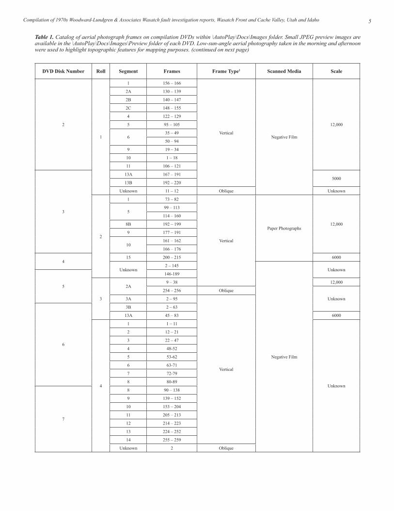
Table 1. Catalog of aerial photograph frames on compilation DVDs within \AutoPlay\Docs\Images folder. Small JPEG preview images are available in the \AutoPlay\Docs\Images\Preview folder of each DVD. Low-sun-angle aerial photography taken in the morning and afternoon were used to highlight topographic features for mapping purposes. (continued on next page)
DVD Disk Number Roll Segment Frames Frame Type1 Scanned Media Scale
2
1
1 156 – 166
VerticalNegative Film
12,000
2A 130 – 139
2B 140 – 147
2C 148 – 155
4 122 – 129
5 95 – 105
635 – 49
50 – 94
9 19 – 34
10 1 – 18
11 106 – 121
3
13A 167 – 1915000
13B 192 – 220
Unknown 11 – 12 Oblique Unknown
2
1 73 – 82
Vertical
Paper Photographs12,000
599 – 113
114 – 160
8B 192 – 199
9 177 – 191
10161 – 162
166 – 176
415 200 – 215 6000
Unknown2 – 145
Negative Film
Unknown
5
146-189
3
2A9 – 38 12,000
254 – 256 Oblique
Unknown3A 2 – 95
Vertical
6
3B 2 – 63
13A 45 – 83 6000
4
1 1 – 11
Unknown
2 12 – 21
3 22 – 47
4 48-52
5 53-62
6 63-71
7 72-79
8 80-89
7
8 90 – 138
9 139 – 152
10 153 – 204
11 205 – 213
12 214 – 223
13 224 – 252
14 255 – 259
Unknown 2 Oblique

Utah Geological Survey6
The frames included in OFR-548 contained large areas of very dark shadowing, limiting their usefulness.
Due to the large file size of these images and to reduce the number of DVD disks included in this publication, the final processed frames were saved using JPEG compression at a Photoshop quality level of nine within the TIFF files. This compression scheme results in high image quality with few artifacts present in the final images.
To provide an index map for the aerial photographs included in this compilation, we determined the center point of each im-age scan using a grid in Adobe Photoshop software. We then compared the photo center point locations to recent Google Earth imagery to detemine approximate spatial coordinates in the simple cylindrical (Plate Carree or latitude/longitude) pro-jection, World Geodetic System of 1984 (WGS84) datum. We projected the center point coordinates to the North American Datum of 1983 (NAD83) datum, and then used the coordi-nates to create index maps for the photographs accompyaning each report as a Google Earth KMZ and as an ESRI ArcGIS v 10.2 feature class within a file geodatabase for use in GIS software. Due to the lack of an original index map and the variable frame numbering system used, it is not known if any originally flown frames are missing from this compilation.
Once individual frames are identified from the indexes, the corresponding high-resolution TIFF files may be located on the \AutoPlay\Docs\Images\ folder of each DVD (table 1). Table 1 contains a catalog of roll, segment, and frame num-
bers for each DVD. Figure 4 shows the individual graphic file naming convention using roll, segment, and frame num-ber designations. Due to the number of scanned frames and large file sizes, the TIFF image files span eight DVDs (DVD 1 contains the index maps and publication files, DVDs 2-9 contain the photograph frame image files). Small JPEG pre-view images are available in the \AutoPlay\Docs\Images\Pre-view folder of each DVD for rapid viewing and searching for frames.
The full-resolution TIFF and preview JPEG images can be viewed, processed, and converted to other file formats using suitable software, such as IrfanView (freeware for non-com-mercial use, http://www.irfanview.com/), GIMP (free soft-ware to all under the GNU General Public License [GPL], http://www.gimp.org/), Google Picasa (freeware, http://pica-sa.google.com/), Adobe Photoshop, and Apple Aperture.
Figure 4. File naming convention for full-resolution TIFF (TIF) and preview JPEG (JPG) images in compilation.
7
5
1 1 – 17
VerticalNegative Film
Unknown2 28 – 39
8
3 40 – 45
4 46 – 61
5 67 – 87 6000
6 92 – 103 Unknown
7 109 – 121
Unknown
8 122 – 141
9 142 – 150
Unknown11 – 12
88 – 91 Oblique
6
1 123 – 128
Vertical
Paper Photographs
2 129
3 142 – 146
4 147 – 160
5 161 – 193
9
6 194 – 195
Unknown 2 – 162 Negative Film
Unknown 131 – 141 Paper Photographs1 All frames were taken with a low sun angle.
Table 1. Continued from page 5.
7Compilation of 1970s Woodward-Lundgren & Associates Wasatch fault investigation reports, Wasatch Front and Cache Valley, Utah and Idaho
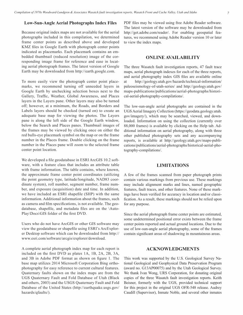
Low-Sun-Angle Aerial Photographs Index Files
Because original index maps are not available for the aerial photographs included in this compilation, we determined frame center points as described above and developed KMZ files in Google Earth with photograph center points indicated as placemarks. Each placemark contains an em-bedded thumbnail (reduced resolution) image of the cor-responding image frame for reference and ease in locat-ing aerial photograph frames. The latest version of Google Earth may be downloaded from http://earth.google.com.
To more easily view the photograph center point place-marks, we recommend turning off unneeded layers in Google Earth by unchecking selection boxes next to the Gallery, Traffic, Weather, Global Awareness, and Places layers in the Layers pane. Other layers may also be turned off; however, at a minimum, the Roads, and Borders and Labels layers should be checked (turned on) to create an adequate base map for viewing the photos. The Layers pane is along the left side of the Google Earth window, below the Search and Places panes. Thumbnail images of the frames may be viewed by clicking once on either the red bulls-eye placemark symbol on the map or on the frame number in the Places frame. Double clicking on the frame number in the Places pane will zoom to the selected frame center point location.
We developed a file geodatabase in ESRI ArcGIS 10.2 soft-ware, with a feature class that includes an attribute table with frame information. The table contains, where known, the approximate frame center point coordinates (utilizing the point geometry type, latitude/longitude, NAD83 coor-dinate system), roll number, segment number, frame num-ber, and exposure (acquisition) date and time. In addition, we have included an ESRI shapefile (SHP) with the same information. Additional information about the frames, such as camera and film specifications, is not available. The geo-database, shapefile, and metadata files are on the \Auto-Play\Docs\GIS folder of the first DVD.
Users who do not have ArcGIS or other GIS software may view the geodatabase or shapefile using ESRI’s ArcExplor-er Desktop software which can be downloaded from http://www.esri.com/software/arcgis/explorer/download.
A complete aerial photograph index map for each report is included on the first DVD as plates 1A, 1B, 2A, 2B, 3A, and 3B in Adobe PDF format as shown on figure 1. The base map utilizes 2014 Microsoft Corporation Bing ortho-photography for easy reference to current cultural features. Quaternary faults shown on the index maps are from the UGS Quaternary Fault and Fold Database of Utah (Black and others, 2003) and the USGS Quaternary Fault and Fold Database of the United States (http://earthquake.usgs.gov/hazards/qfaults/).
PDF files may be viewed using free Adobe Reader software. The latest version of the software may be downloaded from http://get.adobe.com/reader/. For enabling geospatial fea-tures, we recommend using Adobe Reader version 10 or later to view the index maps.
ONLINE AVAILABILITY
The three Wasatch fault investigation reports, 47 fault trace maps, aerial photograph indexes for each of the three reports, and aerial photography index GIS files are available online at http://geology.utah.gov/hazards/technical-information/paleoseismology-of-utah-series/ and http://geology.utah.gov/maps-publications/publications/aerial-photographs/histori-cal-aerial-photography-compilations/.
The low-sun-angle aerial photographs are contained in the UGS Aerial Imagery Collection (https://geodata.geology.utah.gov/imagery/), which may be searched, viewed, and down-loaded. Information on using the collection (currently over 88,000 frames) is available by clicking on the Help tab. Ad-ditional information on aerial photography, along with three other published photography sets and any accompanying reports, is available at http://geology.utah.gov/maps-publi-cations/publications/aerial-photographs/historical-aerial-pho-tography-compilations/.
LIMITATIONS
A few of the frames scanned from paper photograph prints contain various markings from previous use. These markings may include alignment marks and lines, named geographic features, fault traces, and other features. None of these mark-ings have been verified for accuracy in location and/or classi-fication. As a result, these markings should not be relied upon for any purpose.
Since the aerial photograph frame center points are estimated, some undetermined positional error exists between the frame center points reported and actual ground locations. Due to the use of low-sun-angle aerial photography, some of the frames contain significant areas of shadowing in mountainous areas.
ACKNOWLEDGMENTS
This work was supported by the U.S. Geological Survey Na-tional Geological and Geophysical Data Preservation Program (award no. G13AP00075) and by the Utah Geological Survey. We thank Ivan Wong, URS Corporation, for donating original copies of the three Wasatch fault investigation reports. Keith Beisner, formerly with the UGS, provided technical support for this project in the original UGS OFR-548 release. Audrey Caudill (Supervisor), Inmate Noble, and several other inmates

Utah Geological Survey8
of UCI provided digital scanning support. Chris DuRoss, Bill Lund, and Mike Hylland provided helpful reviews of this report.
REFERENCES
Black, B.D., Hecker, S., Hylland, M.D., Christenson, G.E., and McDonald, G.N., 2003, Quaternary fault and fold database and map of Utah: Utah Geological Survey Map 193DM, scale 1:500,000, CD.
Bowman, S.D., Beisner, K., and Unger, C., 2009, Compilation of 1970s Woodward-Lundgren & Associates Wasatch fault investigation reports and oblique aerial photogra-phy, Wasatch Front and Cache Valley, Utah and Idaho: Utah Geological Survey Open-File Report 548, 3 p., 6 plates, 9 DVD set.
Slemmons, D.B., 1969, New methods for studying regional seismicity and surface faulting: American Geophysical Union Transactions, EOS, v. 50, p. 397–398.
Utah Automated Geographic Reference Center, 2011, 2011 NAIP 1 meter orthophotography: online, http://gis.utah.gov/data/aerial-photography/2011-naip-1-meter-ortho-photography, accessed April 2014.