paleolithic settlement patterns in northern bosnia
TRANSCRIPT

Preistoria Alpina - Museo Tridentino di Scienze Naturali Vo!. 28 (1992)
ANTA MONTET-WHITE
Paleolithic Settlement Patternsin Northern Bosnia
ABSTRACT
MONTET-WHITE A., 1993 - Paleolithic Settlement Patterns in Northern Bosnia. [Modellidi insediamento paleolitico nella Bosnia settentrionale]. Preistoria Alpina, 28: 91-102.
This review of available data from Paleolithic sites of Northern Bosnia attempts togenerate trends in settlements patterns through time. The focus is on two episodes ofPaleolithic occupation attributed to the Aurignacian and the Gravettian respectively.During the Aurignacian, human occupation is limited to brief incursion along rivervalleys in order to procure raw materials and perhaps animal resources as well. TheLate Upper Paleolithic occupations are better understood. The LUP settlement systemincluded base camps and hunting stations that extended well into the Central European lowlands. The mountain zones of northern Bosnia were at the boundary of hunting territories and appear to have been occupied sparingly during the Paleolithic. Asummary of the reduction sequence at an Aurignacian workshop is presented.
Parola chiave: Paleolitico, Bosnia, modelli di insediamento, sequenza di riduzione.
Key words: Paleolithic, Bosnia, settlement patterns, reduction sequence.
Anta Montet- White, Department ofAnthropology, University ofKansas, Lawrence, KS66045, USA.
91

Knowledge of Paleolithic settlements in northern Bosnia derives in large part fromthe surveys, tests and surface collections done by a single individual, Djuro Basler, whoin the 50's and 60's recorded about 70 sites. His survey focused on the series of loamdeposits that accumulated on the region's uplands and bluff slopes in the latePleistocene. Erosion, construction works and cultivation combined to destroy these deposits in many areas. But remanants were still visible at the time of the survey andBasler's strategy was to spot and examine localities where traces of these deposits couldbe seen. Most of his research focused on the Doboj Basin at the confluence of the Bosnaand the Usora Rivers, the Derventa and KulaSi areas along the Ukrina. Excavations wereconducted at several sites, including Londza (BASLER, 1961) and Kamen in the Dobojbasin, LuS'Cic (BASLER & JANEKOVIC, 1961) and Mala Gradina (BASLER, 1978) near KulaSi,Visoko Brdo (BASLER, 1962) near Derventa, and more recently at Kadar and Zobiste(MONTET-WHITE, LAVILLE & LEZINE, 1986).
In addition, MALEZ and his collaborators (1974) did limited work at several cavesites and a few more open-air sites came to light recently as a result of salvage workalong the Vrbas. In spite of obvious limitations, the recorded sites provide a spatial andtemporal cross section of Paleolithic settlements in the region. A review of available evidence indicates that, during the Paleolithic, human occupations were sporadic and marginal in comparison to other areas of the Central European Basin where greater concentrations of Paleolithic sites have been identified. The contrast between Northern Bosniaand other sections of central Europe raises questions concerning the dynamics of humansettlements in the region and the organization of territories and margins during thePaleolithic.
The following is a brief outline of results and questions for a region that stretchesfrom the low lying plain of the Sava River to the mountains and high plateaus of theDinaric Alps.
1. Spatial distribution of Paleolithic sites
Northern Bosnia is a region of dissected landscape limited by the Sava River to thenorth, the Una River to the west and the Drina River to the east. The system of parallelvalleys that runs from south to north into the Sava are the most notable topographic features of the region. In their upper course the rivers cut narrow valleys through mountainsthat reach altitudes of 1000 m and above and basins form at the confluences of severalstreams. Valleys widen in their mid and lower sections where surrounding uplands rangebetween 600 m and 400 m sloping down to about 120 m along the Sava ridge. In termsof climate and vegetation, the region now forms a transition between the modifiedMediterranean environment of the Dinaric Alps and that of the Central European Plain.A different situation prevailed in the late Pleistocene especially when lower sea levelsreduced the Adriatic to a gulf. The region that includes the Sava and its southern tributaries was then an integral part of the Central European Basin. And the spatial distribution of Paleolithic sites must be considered in the light of the region's geographic situation as a boundary as well as a transition between two environmental zones.
A first series of sites is located in the lower section of the valley immediately alongthe Sava ridge, like Kadar, or close to it, like Peeine on the Vrbas. A second series is
92

found in the valleys' midsections. Some are located on a ledge along the bluff likeLondza and Kamen and others occupy the hilltops like Zobiste and Visoko Brdo. A thirdgroup is located on hilltops and terraces further up river and well into the mountainzone. The KulaSi sites in a somewhat wider, more open area at the junction of the 2 upper branches of the Ukrina are the best examples of the third group. Lastly, the cavesites near the rivers headwaters contain faunal remains of bear, marmot and other cavedwellers as well as occasional traces of human occupation. But there is a marked contrast between the Bosnian cave sites so seldom used by Paleolithic hunters (BASLER,1979) and the Slovenian (OSOLE, 1965, 1979) and, more especially, the Croatian karstcaves like Vindjia or Veternica located north of the Sava (MALEZ, 1979) where substantial records of Paleolithic occupations were uncovered. A relative scarcity of game inand around the Bosnian caves during the late Pleistocene COllld account for the smallnumber of Paleolithic remains as the relative abundance of faunal resources probablydetermined the organization of seasonal rounds and hunting territories. A comparativestudy of faunal assemblages from caves north and south of the Sava River would shedsome light on the matter as, unfortunately, bone is not preserved in the acidic sedimentsof the known open-air sites.
2. Temporal distribution of paleolithic occupations
Paleolithic sites range from Mousterian to Epigravettian. However, recorded assemblages cluster in well defined groups and the region's cultural sequence includesseveral major stratigraphic gaps.
(1) Mousterian levels in place have been recorded at Visoko Brdo, Kadar, ZobiSteand Londza (fig. 1). Laville (MONTET-WHITE, LAVILLE & LEZINE, 1986) placed Kadar,ZobiSte and Visoko Brdo within the same episode marked by relative humidity. His viewis confirmed by the Kadar pollen profile which records percentages of arboreal pollenvarying between 24 and 48 and includes a variety of deciduous trees as well as pine. TLdates derived from burned flint samples from ZobiSte place these occupations around90,000. Assemblages recovered from these sites are characterized by the relative importance of Levallois debitage and high frequencies of naturally backed knives and sidescrapers (BAUMLER, 1989).
A number of sites recorded by BASLER (1979) were identified as Mousterian. Although information about the sedimentological context of these scattered finds is lacking' the lithic assemblages they yielded belong to the same type of industry as ZobiSteand may be assumed to have been roughly contemporaneous. This suggests a strong implantation of early Mousterian groups in the region and a single horizon which fallswithin the early stages of the last glaciation.
(2) Aurignacian components were identified at LtiSCic and Mala Gradina nearKulaSi and at Londza and Kamen near Doboj (fig. 2). At Londza artifacts were foundwithin a 30 cm thick deposits which may indicate recurring occupations. At LtiSCic, onthe other hand, the Aurignacian level was one artifact thick representing perhaps a singleoccupation.
93

Fig. 1 - Distribution of Mousterian sites along the Bosna, Ukrina and Vrbas Rivers. 1, Kadar; 15,Londza; 4, ZobiSte; 5, Visoko Brdo; 6, Rastuca Cave.
The LtiSCic archaeological horizon was found in layer III which Laville describedas a sediment of aeolien origin affected by the formation of a polygonal network (systeme de fentes polygonales). He related the sediments alteration to the inter KrinidesPhotolivos cold episode which is largely confirmed by TL dates ranging between 30,000and 27,000 BP (MONTET-WHITE, LAVILLE & LEZINE, 1986). Several other Aurignaciansites were located around KulaS'i. Mala Gradina was probably the most important but thestratigraphic context of the Paleolithic artifacts is not known.
The time period that corresponds to the inter MousterianlEpigravettian (60-20,000)is not registered in the stratigraphic sequence of the plateau sites. Epigravettian levelsare directly superimposed on the Mousterian bearing sediments at Kadar, at ZobiSte andprobably also at Visoko Brdo indicating a major erosional episode that affected largesections of the region's deposits. So the view we have of the distribution of Aurignaciansettlements is seriously handicapped by a stratigraphic hiatus. Available data, especiallythe thin cultural horizon at LuSCic, suggests a more limited implantation than during theMousterian and perhaps no more than brief incursions in the Ukrina and Bosna valleys.The site of Peeine, north of Banja Luka, on the west bank of the Vrbas river, on the otherhand, appears to contain an abundance of materials and a variety of artifacts forming a
94

Fig. 2 - Distribution of Aurignacian sites along the Bosna, Ukrina and Vrbas Rivers. 40, Luscic;39, Mala Gradina; 36 Londza.
thick accumulation. The site has not been systematically excavated but it seems a goodcandidate for a residential camp and the only one for the Aurignacian. A settlement shiftfrom one valley system to another during the time period corresponding to theAurignacian is a possible interpretation that further field work could consider and elucidate.
(3) A series of Epigravettian occupations were recorded at Kadar where they corresponded to a period of aeolian sedimentation and soil formation. The pollen diagramshowed that a park steppe with 17 to 28% arboreal pollen (oak, linden, elm, hazel, andpine) covered the area at the time. Laville associated the layer with the Philippi stage ofthe Thenaghi-Philippon sequence. The Tl dates place the Epigravettian between 24,200 ±2,000 (I-west level 2b) and 16,200 ± 2,000 for level 2a. The Kadar industries were relatedto the shouldered point horizon found also in Slovenia, Croatia and along both sides of theAdriatic Basin (MONTET-WHITE & KOZLOWSKI, 1985). Other Epigravettian componentswere recorded at ZobiSte and Londza but at both sites the levels were truncated by earlyHolocene erosional surfaces and further dismantled by plowing. The «gravettian» level atVisoko Brdo could be associated with an earlier phase; it contained very few artifacts.
95

Fig. 3 - Distribution of Late Paleolithic sites in the Sava and Drava region. 1, Kadar.
The map illustrating the distribution of sites attributed to the late Upper Paleolithic(fig. 3) shows that territories occupied at that period extended toward lowlands andplains while less use was made of the midmountain zones. A shift in hunting strategiesand group organization at the time of the last glacial maximum may well account for thechange in settlement pattern.
3. Site function and site use
3.1. Spatial organization ofarchaeological materials within sites
Sites recorded to date consist of artifact scatters, 10 m to 25 m in diameter, covering 120 to 260 m2 in surface area, and comprised of lithic tools and debitage,hammerstones, abraders and anvils. At the exception of Kadar where bovid teeth wererecovered, bone is not preserved in the highly acidic sediments of the Bosnian open-air
96

sites. The Kadar hearths and posthole are the only identified site features in the region.As a result, the quantities and varieties of lithic artifacts are the only kind of data thatcan be used to infer sites function. Even within the limits of available evidence, the contrast in terms of site use between Kadar, the only well preserved Epigravettian site, andLuSCi6, the most recently excavated Aurignacian site is clearly marked. The quantity andvariety of artifact types and tools recovered from the site as well as the spatial patterningidentified within and between different areas of the site set Kadar apart. It is clear thatKadar was a camp where multiple activities were performed. What is more, activitieswere spatially segregated reflecting the organization of various tasks within the groupwho occupied the camp. Lastly, the site was occupied repeatedly over a long period oftime.
LuSCi6 presented a very different situation. The most notable piece of site furniturerecovered during the 1980 excavations was a large sandstone slab broken in 3 pieceswhich was marked with striations and pitting. Cores and hammerstones were scatteredaround. Curiously, the area surrounding the anvil was relatively clear of debris and thedensity of lithic debitage increased as one moved away from the anvil. The observedpatterning indicated some level of spatial organization. But in contrast to Kadar, therewas no difference between the site's different spatial units; all units contained the samecategories of debitage and tools indicating repeated performances of similar tasks.
3.2. Reduction sequence and raw material use
Notable differences in the use of raw material resources separate Kadar and LuSCi6.In both cases the raw material consisted of radiolarite cobbles collected from river gravels. LuSCi6 was right at the river edge and the site's occupants had immediate access toan abundant resource whereas Kadar was a few miles away from the nearest gravel bar.
Pie diagrams (figs. 4 and 5) illustrate how an «average» cobble was used at eachsite. It is immediately evident that cores represent a much higher percentage of the rawmaterial volume at LuS'Ci6 than at Kadar. Tools and blades constitute less than 10% ofthe volume of raw material processed at LuSCi6 but account for 33 % at Kadar. The highproportion of blades and tools found at Kadar (table I) is indicative of intensive use oflithic resources whereas LilSci6 is marked by a much greater proportion of flakes and alow level of blade and tool production.
Furthermore, the relative proportion of blades to cores (an average of 18 blades percore at Kadar, 9 per core at LuSCi6) and that of tools to blades (1.5 / 2 blades for 1 tool at
Table 1 - Artifacts Distribution at Kadar and LliSCic.
Kadar le Kadar Iw LuSCi6 (1980)
Excavated Surface Area 55 m2 32 m2 24m2
Cores 16 2% 28 3% 15 3%Blades 387 44% 416 48% 141 24%Flakes 290 33% 125 14% 397 68%Tools 185 21% 295 34% 29 5%
97
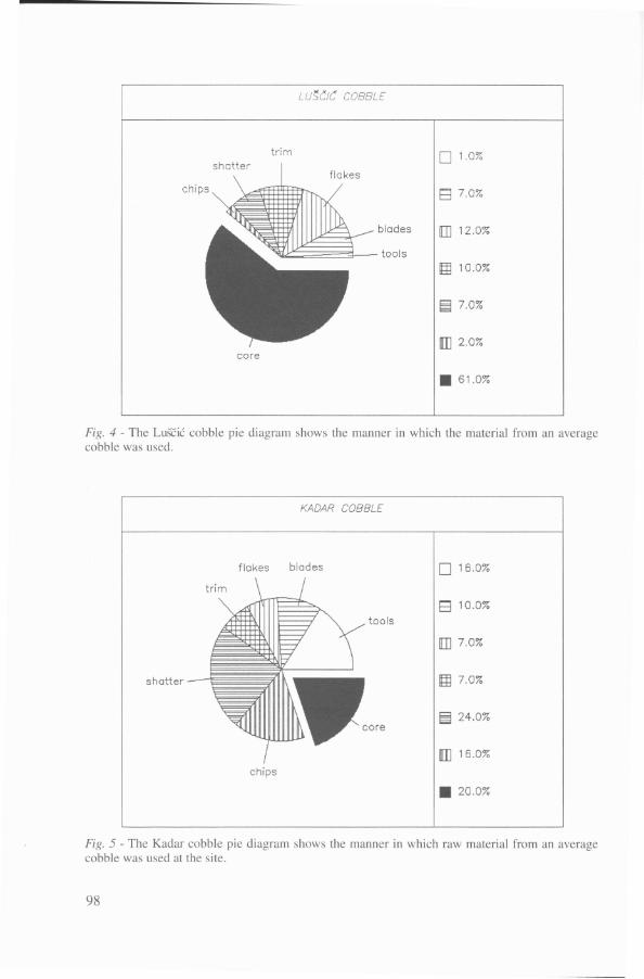
LU~CIC COBBLE
trim D 1.0%
El 7.0%
blades [ill 12.0%
tools
~ 10.0%
~ 7.0%
DJ 2.0%core
11 61.0%
Fig. 4 - The Luscic cobble pie diagram shows the manner in which the material from an averagecobble was used.
KADAR COBBLE
flakes blad es
shatter-iiltWiichips
D 16.0%
B 10.0%
tools
[] 7.0%
~ 7.0%
~ 24.0%
DJ 16.0%
11 20.0%
Fig. 5 - The Kadar cobble pie diagram shows the manner in which raw material from an averagecobble was used at the site.
98

Kadar, 4 blades for 1 tool at LuSCic) reflect the more intensive preparation and use oflithic tools at Kadar, consistent with its functioning as a base camp. A more detailedanalysis of the LuS'cic assemblage provided a better understanding of the range of activities performed at the site. The assemblage included products and by-products of a bladeproduction technology (table 11). The assemblage is clearly that of a workshop where alarge number of cobbles were brought in and tested. Many cobbles shattered since alarge proportion of the cobbles were subjected to sub freezing conditions. The numberof initial flakes (entames) is relatively high compared to Kadar where there were only 2amidst a much larger assemblage of artifacts and tools, implying that at the latter sitecobbles were introduced after some initial testing.
Table 2 - The LuSCic assemblage.
Shatter
Initial flakesCortical flakes:
«Lemon wedges»parallel dorsal pattern:
lateral cortexdistal cortex
multidirectional dorsal pattern:lateral cortexdistal cortexproximal cortex
Pre-coresPlatform tabletsCrest blades
Internal flakes:parallel dorsal patternmultidir. dorsal pattern
Flake fragmentsChips
Cortical blades:lateral cortexdistal cortex
Complete bladesBlade fragmentsCores
Tools
Cobble testing:176
Core Preparation:25
7
143
20114
5392
Core maintenance:
2890186315
Blade production:
121
448415
17
99