paleoliquefaction studies in australia to constrain ... · pdf filepaleoliquefaction studies...
TRANSCRIPT
Paper Number 50
Paleoliquefaction studies in Australia to constrainearthquake hazard estimates
C. Collins, P. Cummins & D. ClarkGeoscience Australia. GPO Box 378, Canberra, ACT 2601, [email protected]
M. TuttleTuttle & Associates, HC 33 Box 48, Bay Point Road, Georgetown, Maine04548, USA
R. Van ArsdaleCenter for Earthquake Research & Information, University of Memphis.3890 Central Ave. Memphis, Tennessee 38152, USA
2004 NZSEEConference
ABSTRACT: Australia has a low rate of modern seismicity compared to plate marginregions, and a short historical record of earthquakes. These factors combined manifest assignificant uncertainty in the Australian earthquake hazard map. One approach to addressthe problem of sparse historic seismicity in intraplate regions like Australia is to usepaleoliquefaction studies to constrain the occurrence of prehistoric earthquakes.Liquefaction was observed following large historic earthquakes in South Australia andVictoria, and numerous ‘sand blows’ were observed following the 1968 Meckeringearthquake in Western Australia. It is therefore likely that prehistoric earthquakes inthese areas would have also induced liquefaction. Liquefaction deposits might also beanticipated in other areas which are geologically prone to liquefaction, but have notexperienced an historical earthquake. Four areas were investigated for paleoliquefaction:(1) southeastern South Australia, the site of pronounced liquefaction associated with alarge (Ms 6.5) 1897 earthquake; (2) Meckering the site of the 1968 Ms 6.8 earthquake inthe South West Seismic Zone; (3) the Perth region, a major urban centre situated in alarge sedimentary basin west of the South West Seismic Zone, and (4) the Goulburn rivernear the Cadell fault in Victoria, whose banks consist of poorly consolidated fluvialsediments and lie near a large fault which experienced slip in the Quaternary. In thispaper we discuss why we have chosen these sites as having high potential forpaleoliquefaction studies, and present some results from preliminary surveys at the fourtarget areas.
INTRODUCTION
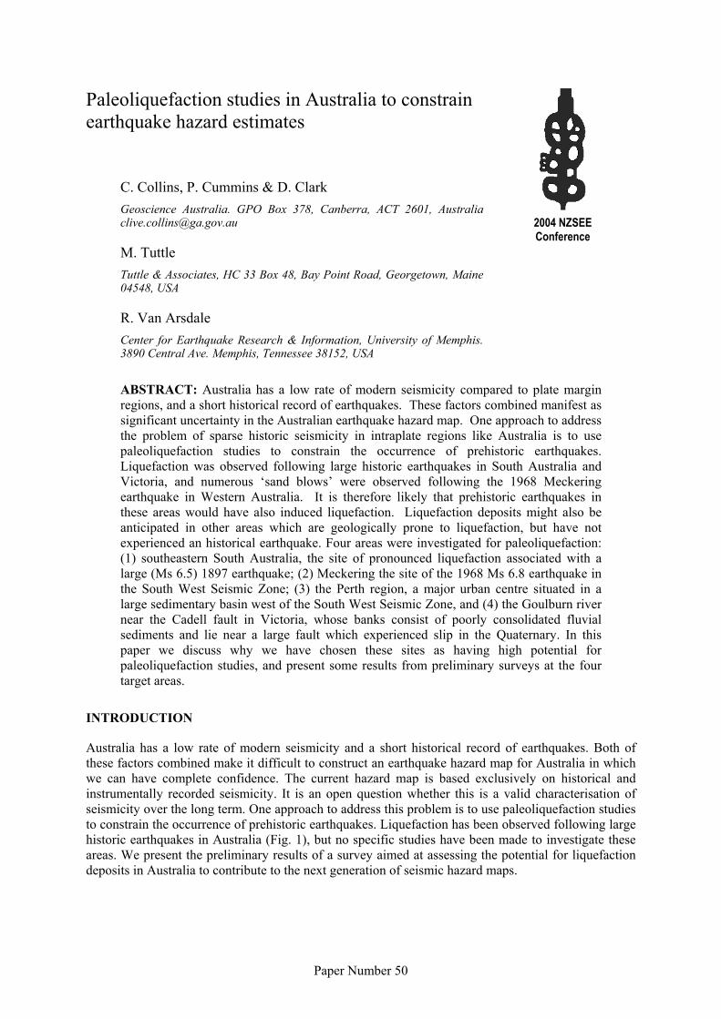
Australia has a low rate of modern seismicity and a short historical record of earthquakes. Both ofthese factors combined make it difficult to construct an earthquake hazard map for Australia in whichwe can have complete confidence. The current hazard map is based exclusively on historical andinstrumentally recorded seismicity. It is an open question whether this is a valid characterisation ofseismicity over the long term. One approach to address this problem is to use paleoliquefaction studiesto constrain the occurrence of prehistoric earthquakes. Liquefaction has been observed following largehistoric earthquakes in Australia (Fig. 1), but no specific studies have been made to investigate theseareas. We present the preliminary results of a survey aimed at assessing the potential for liquefactiondeposits in Australia to contribute to the next generation of seismic hazard maps.
2
Figure 1 Map of Australian seismicity for magnitude M > 4. Yellow squares show areas investigated forevidence of palaeoliquefaction.
PALAEOLIQUEFACTION STUDY AREAS
In 1897, liquefaction was observed during a large (Ms 6.5) earthquake near Beachport, southeasternSouth Australia. In 1968, numerous ‘sand blows’ were observed following the Ms 6.8 earthquake atMeckering in Western Australia. It is likely, therefore, that prehistoric earthquakes in these areaswould have also induced liquefaction. Liquefaction deposits might also be anticipated in other areaswhich are geologically prone to liquefaction, but have no record of large historical earthquakes. Basedon this historical evidence, and the potential for paleoliquefaction during pre-historic earthquakes, fourareas were chosen for investigation. These areas were: (1) southeastern South Australia nearBeachport; (2) the Meckering area, in the South West Seismic Zone of Western Australia; (3) thePerth region, a major urban centre situated in a large sedimentary basin west of the South WestSeismic Zone; and (4) the Goulburn River in Victoria, whose banks consist of poorly consolidatedfluvial sediments near the Cadell fault, a large fault scarp which developed in the Quaternary.
Study Area 1: 1897 Beachport Earthquake Epicentral Area, South Australia
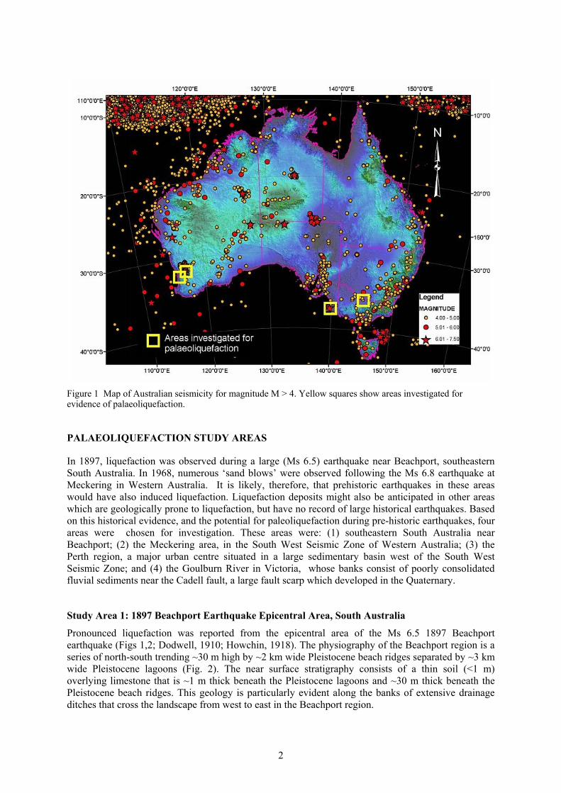
Pronounced liquefaction was reported from the epicentral area of the Ms 6.5 1897 Beachportearthquake (Figs 1,2; Dodwell, 1910; Howchin, 1918). The physiography of the Beachport region is aseries of north-south trending ~30 m high by ~2 km wide Pleistocene beach ridges separated by ~3 kmwide Pleistocene lagoons (Fig. 2). The near surface stratigraphy consists of a thin soil (<1 m)overlying limestone that is ~1 m thick beneath the Pleistocene lagoons and ~30 m thick beneath thePleistocene beach ridges. This geology is particularly evident along the banks of extensive drainageditches that cross the landscape from west to east in the Beachport region.
3
Figure 2 Geological map of the Beachport area and photograph of slumping observed after the 1897 earthquake.
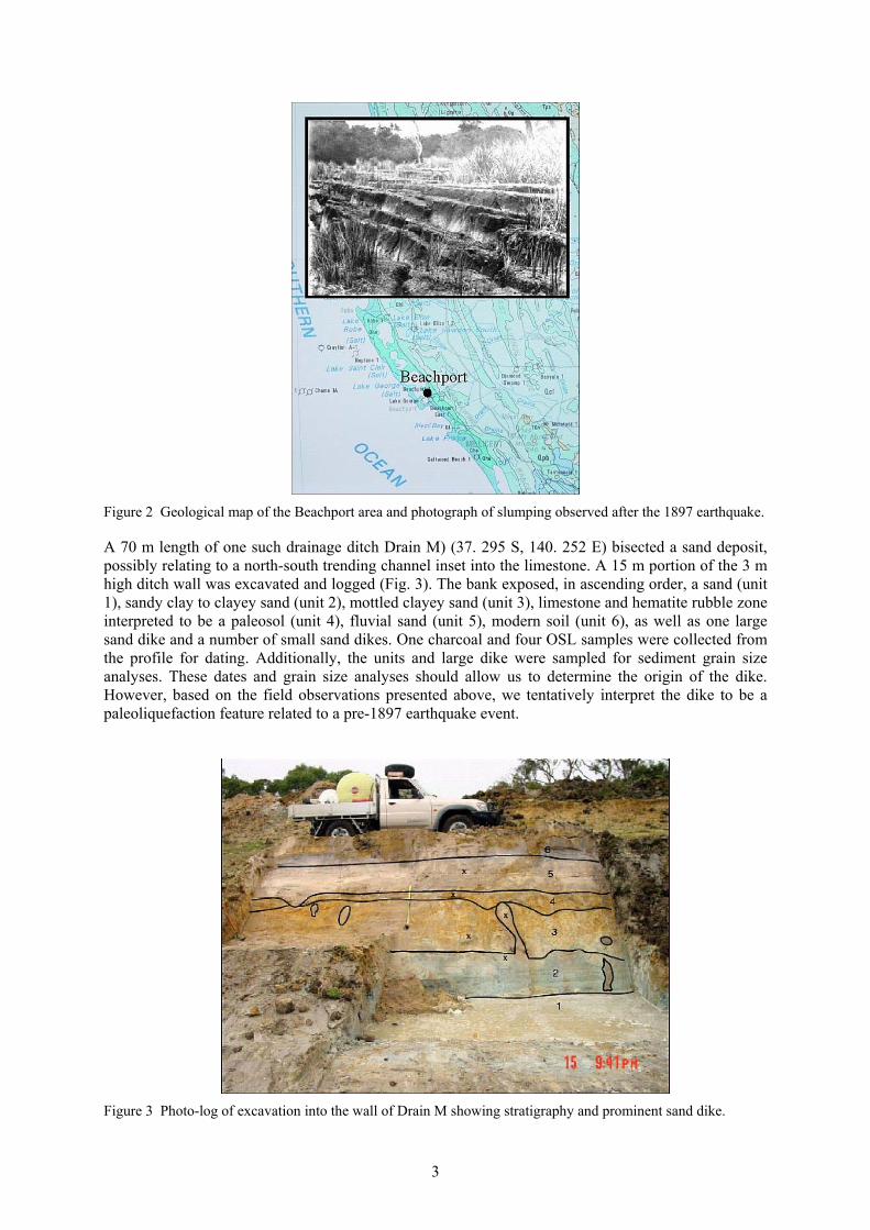
A 70 m length of one such drainage ditch Drain M) (37. 295 S, 140. 252 E) bisected a sand deposit,possibly relating to a north-south trending channel inset into the limestone. A 15 m portion of the 3 mhigh ditch wall was excavated and logged (Fig. 3). The bank exposed, in ascending order, a sand (unit1), sandy clay to clayey sand (unit 2), mottled clayey sand (unit 3), limestone and hematite rubble zoneinterpreted to be a paleosol (unit 4), fluvial sand (unit 5), modern soil (unit 6), as well as one largesand dike and a number of small sand dikes. One charcoal and four OSL samples were collected fromthe profile for dating. Additionally, the units and large dike were sampled for sediment grain sizeanalyses. These dates and grain size analyses should allow us to determine the origin of the dike.However, based on the field observations presented above, we tentatively interpret the dike to be apaleoliquefaction feature related to a pre-1897 earthquake event.
Figure 3 Photo-log of excavation into the wall of Drain M showing stratigraphy and prominent sand dike.
4
Study Area 2: 1968 Meckering Earthquake Epicentral Area
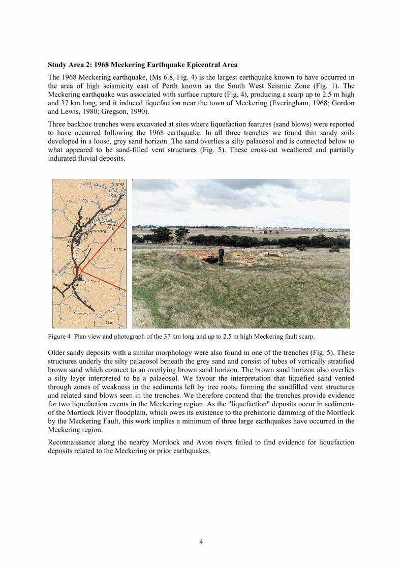
The 1968 Meckering earthquake, (Ms 6.8, Fig. 4) is the largest earthquake known to have occurred inthe area of high seismicity east of Perth known as the South West Seismic Zone (Fig. 1). TheMeckering earthquake was associated with surface rupture (Fig. 4), producing a scarp up to 2.5 m highand 37 km long, and it induced liquefaction near the town of Meckering (Everingham, 1968; Gordonand Lewis, 1980; Gregson, 1990).
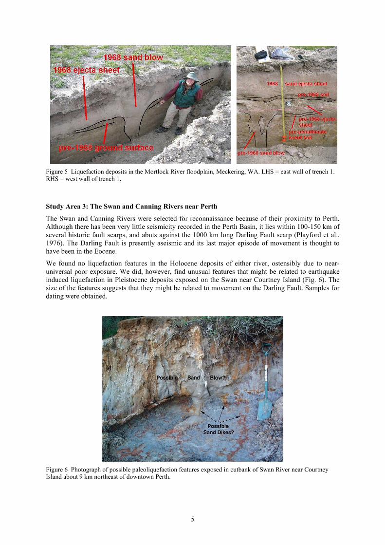
Three backhoe trenches were excavated at sites where liquefaction features (sand blows) were reportedto have occurred following the 1968 earthquake. In all three trenches we found thin sandy soilsdeveloped in a loose, grey sand horizon. The sand overlies a silty palaeosol and is connected below towhat appeared to be sand-filled vent structures (Fig. 5). These cross-cut weathered and partiallyindurated fluvial deposits.
Figure 4 Plan view and photograph of the 37 km long and up to 2.5 m high Meckering fault scarp.
Older sandy deposits with a similar morphology were also found in one of the trenches (Fig. 5). Thesestructures underly the silty palaeosol beneath the grey sand and consist of tubes of vertically stratifiedbrown sand which connect to an overlying brown sand horizon. The brown sand horizon also overliesa silty layer interpreted to be a palaeosol. We favour the interpretation that liquefied sand ventedthrough zones of weakness in the sediments left by tree roots, forming the sandfilled vent structuresand related sand blows seen in the trenches. We therefore contend that the trenches provide evidencefor two liquefaction events in the Meckering region. As the "liquefaction" deposits occur in sedimentsof the Mortlock River floodplain, which owes its existence to the prehistoric damming of the Mortlockby the Meckering Fault, this work implies a minimum of three large earthquakes have occurred in theMeckering region.
Reconnaissance along the nearby Mortlock and Avon rivers failed to find evidence for liquefactiondeposits related to the Meckering or prior earthquakes.
5
Figure 5 Liquefaction deposits in the Mortlock River floodplain, Meckering, WA. LHS = east wall of trench 1.RHS = west wall of trench 1.
Study Area 3: The Swan and Canning Rivers near Perth
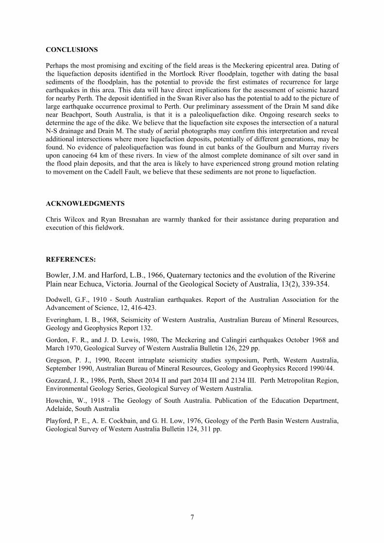
The Swan and Canning Rivers were selected for reconnaissance because of their proximity to Perth.Although there has been very little seismicity recorded in the Perth Basin, it lies within 100-150 km ofseveral historic fault scarps, and abuts against the 1000 km long Darling Fault scarp (Playford et al.,1976). The Darling Fault is presently aseismic and its last major episode of movement is thought tohave been in the Eocene.
We found no liquefaction features in the Holocene deposits of either river, ostensibly due to near-universal poor exposure. We did, however, find unusual features that might be related to earthquakeinduced liquefaction in Pleistocene deposits exposed on the Swan near Courtney Island (Fig. 6). Thesize of the features suggests that they might be related to movement on the Darling Fault. Samples fordating were obtained.
Figure 6 Photograph of possible paleoliquefaction features exposed in cutbank of Swan River near CourtneyIsland about 9 km northeast of downtown Perth.

6
Study Area 4: The Goulburn and Murray River near the Cadell Fault, NSW/Victoria border
No historic events of sufficient magnitude to produce liquefaction have been experienced in theeastern states of Australia (Fig. 1). However, the area is of great interest as the greater proportion ofAustralia's population lives on the eastern seaboard. The Cadell fault is considered a likely source ofearthquake shaking for possible paleo-liquefaction along the Goulburn and Murray River flood plains.The Cadell scarp is 37 km long, over 10 m high in places (Figs 7,8), and has a down-to-the-eastdisplacement (Bowler and Harford, 1966). Thrust displacement on the Cadell fault is thought to havediverted the course of the Murray, possibly as little as 4,000 years ago. Canoe trips were made alongportions of the Goulburn and Murray rivers upstream of Echuca to seek evidence of paleoliquefaction.Most of the bank sediment in these rivers is sandy and clayey silt. The very few sand lenses presentare commonly indurated with iron oxide. No sand dikes were found anywhere along the 64 km of theGoulburn and Murray rivers floated.
Figure 7 The Murray and Goulburn Rivers where they are diverted by the Cadell Fault
Figure 8 Aerial view of the 10 m high Cadell scarp looking NW. Barmah forest formed where the Murray Riverponded, before diverting.
7
CONCLUSIONS
Perhaps the most promising and exciting of the field areas is the Meckering epicentral area. Dating ofthe liquefaction deposits identified in the Mortlock River floodplain, together with dating the basalsediments of the floodplain, has the potential to provide the first estimates of recurrence for largeearthquakes in this area. This data will have direct implications for the assessment of seismic hazardfor nearby Perth. The deposit identified in the Swan River also has the potential to add to the picture oflarge earthquake occurrence proximal to Perth. Our preliminary assessment of the Drain M sand dikenear Beachport, South Australia, is that it is a paleoliquefaction dike. Ongoing research seeks todetermine the age of the dike. We believe that the liquefaction site exposes the intersection of a naturalN-S drainage and Drain M. The study of aerial photographs may confirm this interpretation and revealadditional intersections where more liquefaction deposits, potentially of different generations, may befound. No evidence of paleoliquefaction was found in cut banks of the Goulburn and Murray riversupon canoeing 64 km of these rivers. In view of the almost complete dominance of silt over sand inthe flood plain deposits, and that the area is likely to have experienced strong ground motion relatingto movement on the Cadell Fault, we believe that these sediments are not prone to liquefaction.
ACKNOWLEDGMENTS
Chris Wilcox and Ryan Bresnahan are warmly thanked for their assistance during preparation andexecution of this fieldwork.
REFERENCES:
Bowler, J.M. and Harford, L.B., 1966, Quaternary tectonics and the evolution of the RiverinePlain near Echuca, Victoria. Journal of the Geological Society of Australia, 13(2), 339-354.
Dodwell, G.F., 1910 - South Australian earthquakes. Report of the Australian Association for theAdvancement of Science, 12, 416-423.
Everingham, I. B., 1968, Seismicity of Western Australia, Australian Bureau of Mineral Resources,Geology and Geophysics Report 132.
Gordon, F. R., and J. D. Lewis, 1980, The Meckering and Calingiri earthquakes October 1968 andMarch 1970, Geological Survey of Western Australia Bulletin 126, 229 pp.
Gregson, P. J., 1990, Recent intraplate seismicity studies symposium, Perth, Western Australia,September 1990, Australian Bureau of Mineral Resources, Geology and Geophysics Record 1990/44.
Gozzard, J. R., 1986, Perth, Sheet 2034 II and part 2034 III and 2134 III. Perth Metropolitan Region,Environmental Geology Series, Geological Survey of Western Australia.
Howchin, W., 1918 - The Geology of South Australia. Publication of the Education Department,Adelaide, South Australia
Playford, P. E., A. E. Cockbain, and G. H. Low, 1976, Geology of the Perth Basin Western Australia,Geological Survey of Western Australia Bulletin 124, 311 pp.