paleolimnological investigations of anthropogenic environmental change in lake tanganyika: ix....
TRANSCRIPT

-1
Paleolimnological investigations of anthropogenic environmental change in
Lake Tanganyika: IX. Summary of paleorecords of environmental change
and catchment deforestation at Lake Tanganyika and impacts on the Lake
Tanganyika ecosystem
Andrew S. Cohen1,*, Manuel R. Palacios-Fest2, Emma S. Msaky3, Simone R. Alin4,Brent McKee5, Catherine M. O’Reilly6, David L. Dettman1, Hudson Nkotagu7 andKiram E. Lezzar11Department of Geosciences, University of Arizona, Tucson, AZ 85721 USA; 2Terra Nostra, Tucson, AZ85741, USA; 3Tanzania Petroleum Development Corporation, Dar es Salaam, Tanzania; 4School ofOceanography, University of Washington, Seattle, WA 98195, USA; 5Department of Geology, TulaneUniversity, New Orleans, LA 70118, USA; 6Environmental Science Program, Vassar College, Poughkeepsie,NY 12604 USA; 7Department of Geology, University of Dar es Salaam, Dar es Salaam, Tanzania; *Authorfor correspondence (e-mail: [email protected])
Received 10 July 2004; accepted in revised form 15 January 2005
Key words: Deforestation, East Africa, Lake level, Lake Tanganyika, Late Holocene, Soil erosion
Abstract
Paleorecords from multiple indicators of environmental change provide evidence for the interactions be-tween climate, human alteration of watersheds and lake ecosystem processes at Lake Tanganyika, Africa, alake renowned for its extraordinary biodiversity, endemism and fisheries. This paper synthesizes geo-chronology, sedimentology, paleoecology, geochemistry and hydrology studies comparing the history ofdeltaic deposits from watersheds of various sizes and deforestation disturbance levels along the easterncoast of the lake in Tanzania and Burundi. Intersite differences are related to climate change, differences inthe histories of forested vs. deforested watersheds, differences related to regional patterns of deforestation,and differences related to interactions of deforestation and climate effects. Climate change is linked tovariations in sediment accumulation rates, charcoal accumulation, lake level and water chemistry, espe-cially during the arid-humid fluctuations of the latter part of the Little Ice Age. Differences betweenforested and deforested watersheds are manifested by major increases in sediment accumulation rates in thelatter (outside the range of climatically driven variability and for the last �40 years unprecedented incomparison with other records from the lake in the late Holocene), differences in eroded sediment andwatershed stream composition, and compositional or diversity trends in lake faunal communities related tosediment inundation. Variability in regional patterns of deforestation is illustrated by the timing of tran-sitions from numerous sedimentologic, paleoecologic and geochemical indicators. These data suggest thatextensive watershed deforestation occurred as early as the late-18th to the early-19th centuries in thenorthern part of the Lake Tanganyika catchment, in the late-19th to early-20th centuries in the northernparts of modern-day Tanzania, and in the mid-20th century in central Tanzania. Rapid increases insediment and charcoal accumulation rates, palynological and lake faunal changes occurred in the early-1960s. We interpret this to be the result of greatly enhanced flushing of sediments in previously deforestedwatersheds triggered by extraordinary rainfall in 1961/62. Regional differences in deforestation histories
Journal of Paleolimnology (2005) 34: 125–145 � Springer 2005
DOI 10.1007/s10933-005-2422-4

can be understood in light of the very different cultural and demographic histories of the northern andcentral parts of the lake shoreline. Incursion of slaving and ivory caravans from the Indian Ocean to thecentral coast of Lake Tanganyika by the early-19th century, with their attendant diseases, reduced humanand elephant populations and therefore maintained forest cover in this region through the late-19th toearly-20th centuries. In contrast, the northeastern portion of the lakeshore did not experience the effects ofthe caravan trades and consequently experienced high human population densities and widespreaddeforestation much earlier. These studies demonstrate the importance of paleolimnological data for makinginformed risk assessments of the potential effects of watershed deforestation on long-term lake ecosystemresponse in the Lake Tanganyika catchment. Differences in sediment yield and lake floor distribution ofthat yield, linked to factors such as watershed size, slope, and sediment retention, must be accounted for inmanagement plans for both human occupation of currently forested watersheds and the development offuture underwater reserves.
Introduction
The comparison of paleoenvironmental recordsobtained from various parts of a large lake basinprovides an excellent means of differentiating localvs. regional external processes impacting the lake’secosystem, as well as differentiating local vs. lake-wide responses to those perturbations. In thesepapers published in this issue of the Journal ofPaleolimnology we have used specific sedimento-logic, geochemical and paleoecologic indicators inLake Tanganyika (31�8¢–8�47¢ S, 29�05¢–31�18¢ E,772 masl) to examine changing conditions of cli-mate and watershed land use during the LateHolocene (Cohen et al. 2005; Dettman et al. 2005;McKee et al. 2005; Msaky et al. 2005; Nkotagu2005; O’Reilly et al. 2005; Palacios-Fest et al.2005a, b). Details of coring location and watershedcharacteristics are given in Cohen et al. (2005).Briefly, Lake Tanganyika is the largest and deepestof the East African rift valley lakes. The lakehouses an extraordinary endemic ecosystem, withover 1500 species of organisms at least 600 of whichare endemic to this lake, the product of �10 mil-lion years of lacustrine evolution (Coulter 1991;Cohen et al. 1993a). It is also an extraordinarynatural resource for the region as a result of its verylarge and productive fishery, and as a source offreshwater. Concerns about various environmentalthreats to this ecosystem began to accumulate inthe early 1990s (e.g., Cohen 1991; Lowe-McConnellet al. 1992; Cohen et al. 1996), and were a majormotivating factor behind the development of theUnited Nations Development Programme/GlobalEnvironmental Facility’s Lake Tanganyika Biodi-versity Project (LTBP) in the mid 1990s
(www.ltbp.org). One of the major threats to beassessed by the LTBP was the impact of defores-tation and consequent soil erosion on the LakeTanganyika catchment and ecosystem. The workreported in this special issue and summarized inthis paper represents the paleolimnological andsome of the hydrological investigations associatedwith the LTBP research program, as well ascontinuing investigations of the Nyanza Projectfunded by the National Science Foundation (US)and LTBP, an interdisciplinary research trainingprogram for American and African students ontropical lakes. For these papers we conducted anextensive study involving coring and modern pro-cess studies over several field seasons to gatherpaleorecords of late Holocene environmentalchange in various parts of Lake Tanganyika.
These records each provide evidence for pro-found changes in both the watershed of the lakeand the lake ecosystem itself during the lateHolocene. In this summary paper we present asynthesis of these changes, both spatially andtemporally, in order to better understand therelationship between terrestrial and lacustrineenvironmental changes at Lake Tanganyika.
Intra-site comparisons between data sets
Our synthesis consists of initially comparing theresults from each core site across data sets and thenexamining these sites in the context of both wa-tershed- and regional-scale changes in humandemography and catchment disturbance. For asummary of core site latitudes, longitudes, waterdepth and delta characteristics see the introductory
126

paper in this issue (Cohen et al. 2005, Tables 1 and2, Figures 1–5). Core site summaries are presentedfrom south to north, with an indication for each ofthe present-day level of disturbance from defores-tation impacts within their respective watersheds.We compare key data sets from each of the indi-vidual indicator studies discussed in detail else-where in this issue with each other to infer theabsolute chronologies of depositional events. Theseare displayed against our most current under-standing of lake-level fluctuations in Lake Tang-anyika, compiled from prior sources (Evert 1980;Cohen et al. 1997; Alin and Cohen 2003 and VanAlstine and Cohen 2003) as well as results from thisstudy.
Cores LT-98-2M (6.1653� S, 29.7060� E) and LT-98-12M (6.1655� S, 29.7178� E). Lubulungu River,W. Mahale Mountains, central Tanzanian coast(low disturbance watershed) (Figures 1 and 2)
Cores LT-98-2M and 12M (collected in 110 m and126 m water depth, respectively) collectively
provide us with our longest-duration record,extending back to the mid-Holocene. Although itwas not our original intention to investigate deltaicrecords prior to the last few hundred years, theresults from core LT-98-2M are nonethelessinteresting because they provide information onlandscape variability in the Mahale region longbefore to the modern situation, and serve as a basisof comparison for the levels of variability observedin our late-19th and 20th-century records. Agemodels for both cores are weaker than at mostother sites as a result of the extremely slow andprobably pulsed rates of sedimentation encoun-tered here (McKee et al. 2005).
Core LT-98-2M is characterized by extremelyslow sediment accumulation rates overall, al-though those rates increase markedly upcore(McKee et al. 2005). Between �600 and 700 B.C.,sedimentation at the core site shifted abruptly tofiner muds. This initial fining was associated withincreasing total organic and inorganic carbonaccumulation rates, and a decline in arborealpollen, especially high-elevation conifers. Aroundthe 1st century B.C. charcoal concentration and
Figure 1. Composite chronology for key paleoenvironmental variables from core LT-98-2M (Lubulungu River delta, western Mahale
Mountains, central Tanzania, undisturbed watershed). SMAR = Sediment mass accumulation rate. TOC MAR = total organic
carbon mass accumulation rate. TIC MAR = total inorganic carbon mass accumulation rate. CHAR = charcoal accumulation rate
(expressed as particles (P)/cm2 /yr. AP% = percent arboreal pollen. OAR = ostracode valve accumulation rate. OSR = ostracode
species richness. OSD = ostracode species diversity (Fisher’s alpha). OFRAG = % ostracode valves fragmented.
MOLAR = mollusc shell (bivalves + gastropods) accumulation rate. SAR = sponge spicule accumulation rate. Cross-hatched zone
marks time of initial supersaturation of CaCO3, increased aridification, rising charcoal, and sediment accumulation rates. The lake level
curves for Figures 1–7 incorporate inferences of paleo-lake levels from this study, Cohen et al. (1997) and Alin and Cohen (2003), and
historical data fromEvert (1980) andNASA satellite altimetry data for the post 1980 period (Birkett et al. 1999). Inferred paleo-lake levels
are shown in gray lines and should be treated as qualitative estimates, whereas instrumentally measured levels are shown in black lines.
127

accumulation rates in the core begin to riseappreciably, concurrent with increasing sedimentaccumulation rates (Palacios-Fest et al. 2005a).Benthic calcareous fossils (ostracodes and gastro-pods) make their initial appearance in the record,and sponge spicules also display an abrupt in-crease at this time (Palacios-Fest et al. 2005b).Multiple core records that cover this time intervalfrom other locations in Lake Tanganyika alsoshow this rise in preservation of calcareous skeletalmaterial and calcium carbonate content in general(e.g., Alin and Cohen 2003). This indicates that theabrupt appearance of calcareous fossils is mostlikely a consequence of a deepening of the car-bonate compensation depth throughout the lake,resulting from some combination of increasedcarbonate production and decreased dissolution.The very low levels of carbonate in all mid-lateHolocene cores prior to this time suggest thatabout this time the concentration of calcium car-bonate, and probably all other dissolved solids,underwent a marked increase. Taken in combina-tion with other terrestrial data (charcoal, pollen,sediment accumulation rates), our data points to-ward a major aridification event at this time,consistent with earlier interpretations (Alin andCohen 2003).
Siliciclastic sand input was greatly reduced afterabout 400–500 A.D., by which time the sedimentat the core site was almost completely comprisedof fines. Arboreal pollen concentrations stabilizedat relatively low levels at this same time, followinga long period of decline. Carbonate and ostracode
accumulation rates began to rise at this time aswell, corresponding to the overflow of Lake Kivuinto the Lake Tanganyika basin from the north(Haberyan and Hecky 1987; Cohen et al. 1997).Currently, Lake Kivu (1�34¢–2�31¢ S, 28�49¢–29�21¢ E, 1460 masl, 2700 km2 area) provides amajor source of dissolved solids to the lake, whichprobably account for the rapid rise in ostracodeabundances and total inorganic carbon (TIC)preservation starting in about the 5th century A.D.Palynologic records from the highlands north ofLake Tanganyika point towards substantiallywetter conditions after �720 A.D. (Jolly andBonnefille 1992), and rising lake levels for LakeTanganyika (note declining ostracode fragmenta-tion since approximately the 1st century B.C.) alsosuggest increased water availability after about thelate-6th century A.D., consistent with other lakerecords to the north (Alin and Cohen 2003).However, the terrestrial record from LT-98-2Mdoes not reflect this change, with low arborealpollen concentrations and rising (although low)charcoal concentrations. It is likely that wetterconditions prevailed north of Tanganyika,including those within the high-elevation catch-ment of upstream Lake Kivu and the northernBurundi highlands, but that this trend was absentor at least subdued further south in the MahaleMountains region.
TIC accumulation rates peaked and then rapidlydeclined after �1100 A.D., probably correspondingto decreasing solute inputs (especially Mg and Ca)from Lake Kivu at that time, consistent with both
Figure 2. Composite chronology for key paleoenvironmental variables from core LT-98-12M (Lubulungu River delta, western Mahale
Mountains, central Tanzania, undisturbed watershed). Abbreviations as in Figure 1.
128

a decrease in lake level and drier regionalpaleoclimatic records to the north (Alin and Cohen2003). There is little change in pollen profilesthrough the interval from about the 6th to 12thcentury A.D., again indicating greater climaticinstability north of Tanganyika than in the Mahaleregion over this time period (Msaky et al. 2005).However, a major rise in charcoal MARs beginningin about the early-13th century signals that drierconditions had arrived in the central LakeTanganyika catchment by that time. Rising pro-portions of adults and carapaces at this time alsopoint toward declining lake levels (Palacios-Fest etal. 2005b).
From about the 13th to 15th centuries charcoalflux in LT-98-2M declined slightly and moreevergreen forest pollen is evident, suggesting wet-ter conditions. Declines in ostracode diversityduring this time, along with increasing abundanceof deep-water species such as Gomphocytheredowningi, are consistent with earlier suggestions ofhigher lake levels during this interval (Alin andCohen 2003).
The records from LT-98-2M and LT-98-12Moverlap slightly in the 15–16th centuries A.D. andare generally coherent over this time interval, withdifferences that can be attributed to slightly dif-ferent depositional settings and water depths. LT-98-2M shows an extraordinary rise in charcoalaccumulation rate in about the early 16th century,and while this rise is not captured in the basal partof the LT-98-12M record, charcoal accumulationrates are at their maximal level for this core duringthe same time interval (Palacios-Fest et al. 2005a).High charcoal accumulation rates in approxi-mately the early-16th century are closely followedby evidence of lowered lake levels by about themid-16th Century in the form of ostracode taph-onomic indicators, and increasing mollusk and fishfossil abundances at the core site (Palacios-Fest etal. 2005b). The interval between the 16th and 18thcentury provides evidence for several discrete epi-sodes of low lake levels and aridity, notably inabout the early-mid 18th century, generally con-sistent with earlier interpretations of low standsand aridity for the Lake Tanganyika during thelatter part of the Little Ice Age (Alin and Cohen2003).
After about the late-18th century the core LT-98-12M record demonstrates a major decline insediment accumulation rates on the Lubulungu
delta, which persists to the present. This is accom-panied by a long-term upcore increase in theabundance of arboreal pollen, low elevationeuphorbs and herbs (Msaky et al. 2005). In con-trast, the abrupt 20th century increases in fernspores encountered in most other cores is not evi-dent in this currently protected watershed. Thecombination of a long- term rise in arboreal pollen,declining sediment and charcoal accumulationrates, and indications of deeper water conditionsafter the 18th century are all consistent with thetiming of termination of Little Ice Age aridityand the probable progressive reforestation of thisregion as rainfall increased. Numerous high-eleva-tion areas of the Mahale Mountains National Parkthat are not above thermal tree line, and which re-ceive abundant precipitation, but are currentlybarren of trees, also indicate earlier extensive burns.
Core LT-98-18M (5.9768� S, 29.8167� E). KabesiRiver, N. Mahale Mountains, central Tanzaniancoast (moderate disturbance watershed) (Figure 3)
Core LT-98-18M, collected in 75 m water depth,provides one of our most compelling records ofenvironmental change in the Lake Tanganyikacatchment. An excellent age model is available forthis core, and the profile shows coherent andinterpretable patterns of change, particularly overthe past century (McKee et al. 2005). Charcoalaccumulation rates show a gradual decline fromhigh values during the late-18th century (the arid,latter Little Ice Age) through to about the 1960s,when they rise again dramatically (Palacios-Fest etal. 2005a). Palynologic records show an abruptdecline in grass pollen and increases in arborealpollen (especially low-elevation euphorbs andhigh-elevation trees), fern spores and composites(Msaky et al. 2005). The transition begins in aboutthe late-19th century and accelerates greatly afterthe early-1960s.
Similar timing of change is indicated in manyrecords from this core. Ostracode abundancestarts to increase in about the late-19th centuryand increases rapidly after �1961, as does spongeabundance (Palacios-Fest et al. 2005b). Theostracode record shows a major decline in diversityand an increase in assemblage dominance bywell-preserved juveniles of Romecytheridea longior,a relatively shallow water, muddy-bottom and
129

sedimentation-tolerant species. Although sedimentaccumulation rates do not show any significantchange in the late-19th century, they triple in�1961. Increasing sediment accumulation rates atthat time suggest that both TOC and TIC fluxesmust have increased to maintain their constantproportionality.
The �1961 increase in sediment accumulationrates, TOC and TIC accumulation rates, accu-mulation rates of Romecytheridea longior ostra-codes and sponge spicules are all consistent withindications of less evaporative fractionation fromgroundwater residence in stable isotope records(Dettman et al. 2005). Meanwhile coarse sedimentinput suggests an increase in the efficiency withwhich shallow-water sediment (both suspendedand bed load) was transported offshore to the coresite. There are at least two reasons why such in-creased transport might have occurred. First, totaldischarge of water plus sediment may have in-creased. Alternatively, the position of the pre-dominant distributary channel outlet may havechanged, making the core site more proximal to it.Earthen-work drainage diversions for irrigationpurposes can be observed on the lower Kabesi andnew outlet channels are constructed periodically.However interviews with local residents indicatethat such features were constructed more recentlythan the early 1960s, making the second explana-tion less likely.
The correspondence of the lake signals with thepalynologic record, as well as our approximatehydrologic modeling from stable isotope data,
provides strong support for a total dischargeexplanation. Work by Nkotagu (2005) andDettman et al. (2005) suggests that decreased for-est and woodland cover within the Lake Tang-anyika catchment is likely to be accompanied byincreased hydrologic discharge and reducedgroundwater infiltration, as overland impedimentsto flow are removed from the landscape. Earlyindications of this change may date from the late-19th century, when palynologic changes firstappear, and benthic detritivores first begin toincrease in abundance. However, the largestchanges clearly date from about the early-1960s.
Core LT-98-58M (4.6883� S., 29.6167� E)Nyasanga/Kahama Rivers, Gombe Stream NationalPark, northern Tanzania (low disturbancewatershed) (Figure 4)
Core LT-98-58M, collected in 76 m of water, re-cords a �300 year history adjacent to GombeStream National Park (McKee et al. 2005). Ter-restrial indicators show the previously discussedgrass-arboreal pollen conversion starting in aboutthe 18th century and accelerating in about themid-20th century. Rapidly increasing fern abun-dances and declining grass pollen appear afterabout the early-mid 20th century, along withrising abundance of both low-elevation (Acacia)and high-elevation (Podocarpus) trees (Msaky etal. 2005). Extremely abundant charcoal occursthroughout the core, with the highest values in
Figure 3. Composite chronology for key paleoenvironmental variables from core LT-98-18M (Kabesi River delta, northern Mahale
Mountains, central Tanzania, moderately disturbed watershed). Abbreviations as in Figure 1.
130

about the late-18th to early-19th and the mid- tolate-20th century sediments (Palacios-Fest et al.2005a). In contrast to these indications of ter-restrial disturbance, there is no indication ofconcurrent sedimentologic change or change insediment accumulation rates since about the mid18th century. Inorganic carbon MARs peak inabout the late-18th to early-19th and mid- to late-20th centuries, whereas TOC accumulation ratesand coarse sediments show no pronouncedchanges (Palacios-Fest et al. 2005b). Low butsomewhat variable d15N values on bulk organicmatter persist through the entire core record atthis site, indicating an unimpacted nutrient sourcefor lake phytoplankton rather than soil nitrogenor sewage (O’Reilly et al. 2005).
Benthic invertebrate diversity is very highthroughout this core (Palacios-Fest et al. 2005b).Interestingly, periods of rising ostracode abun-dance parallel periods of rising charcoal accumu-lation. Multivariate analysis of ostracodecommunity structure from LT-98-58M shows nodirectional trend towards a disturbance-tolerantfauna (Alin et al. 2002). Ostracode taphonomicindicators (especially carbonate coatings), alongwith charcoal and sponge spicule records, areconsistent with lowered lake levels and aridity inthe late-18th to early-19th centuries, which are areflection of widespread East African aridity at thistime (Nicholson 1998; Verschuren et al. 2000; Alinand Cohen 2003). For later parts of the record, thepollen and charcoal changes we observe (Msaky etal. 2005; Palacios-Fest et al. 2005a) do not closelymatch any known climatic trends. Given that pol-len and charcoal are easily transported, it is morelikely that they reflect the regional pattern of
changing land use in northern Tanzania andsouthern Burundi during the 19th and 20th centu-ries, rather than providing a watershed-scale signal.This is perhaps not surprising, given the small sizeof the Nyasanga and Kahama drainages. A flatsediment accumulation rate curve and nitrogenisotopes in bulk organic matter from this area arealso consistent with an absence of major soil ero-sion pulses from the Nyasanga/Kahama watershedduring the late-19th to the 20th centuries (O’Reillyet al. 2005). The only terrestrial indicators that maybe attributable to local changes within GombeStream National Park following the establishmentof watershed protection policies in the mid-20thcentury is the apparent increase in woodland treepollen dating from this time. Possible evidence forthis comes from the records of Brachystegiaand Acacia, which occur in the park today aslarge, mid-elevation (1200–1400 m) trees and lowelevation (775–950 m) thickets, respectively(Clutton-Brock and Gillett 1979). No evidenceexists in the pollen records to confirm the conver-sion of low-elevation woodland to canopy forestthat has been observed in recent decades in theprotected park areas (A. Collins pers. comm. 1999).
Core LT-98-37M (4.6227� S, 29.6332� E).Mwamgongo River, Gombe area, northernmostTanzania (high disturbance watershed) (Figure 5)
This core, collected in 95 m water depth, providesa �500 year record of a region that, for most of itshistory, was probably quite similar to the LT-98-58M core Nyasanga/Kahama area several kilo-meters to the south. Contrasts between the two
Figure 4. Composite chronology for key paleoenvironmental variables from core LT-98-58M (Nyasanga/Kahama River delta, Gombe
Stream National Park, northern Tanzania, undisturbed watershed). Abbreviations as in Figure 1.
131

sites are therefore of considerable interest (e.g.,Alin et al. 2002). The Mwamgongo watershed liesjust outside of the Gombe Stream National Parkboundary. The Nyasanga/Kahama watershed hasundergone afforestation starting in the 1950s andhas a relatively small human population of na-tional park personnel, families and visitors today,whereas Mwamgongo has continued to be a site ofincreasing population density over the same time.
Sediment accumulation rates in LT-98-37Mshow a gradual decline from about the 15–18thcenturies, accompanied by a gradual decline ingrain size (McKee et al. 2005; Palacios-Fest et al.2005a). This was followed by low sediment accu-mulation rates until about the mid-19th century.At that time, sediment accumulation rates risedramatically, accompanied by a slight increase ingrain size. A secondary rise in accumulation ratesoccurred in about the early-1960s. Late-20th cen-tury sediment in the core also changes in appear-ance. There is an abrupt switch from oldergreenish-brown muds to younger reddish brownclays, the latter reminiscent of eroded lateriticsoils. This terrigenous sediment change is con-temporaneous with an abrupt decline in TIC (frompreviously high carbonate input), both of whichsuggest terrestrial forcing of sedimentologic chan-ges. The prominent color change was observed inmultiple cores from this delta (Cohen et al. 2005;Palacios-Fest et al. 2005a). The pattern is notobserved in cores from undisturbed deltas atsimilar depths, ruling out simple redox transitionsas a likely explanation. Charcoal and TOC accu-mulation rate profiles are similar to those of TIC,
with peaks in about the early 16th century andincreasing again about the mid 19th century (Pal-acios-Fest et al. 2005a). Surprisingly, absolutecharcoal accumulation rates are lower than for thecurrently undisturbed Nyasanga/Kahama delta.This difference is most likely a consequence ofdifferences in particle delivery and current condi-tions at this site.
The pattern of palynological change in LT-98-37M is quite similar to LT-98-58M, with a grad-ual, long-term decline in grass pollen starting inabout the late-18th to early-19th centuries (Msakyet al. 2005). The decline accelerates in about thelate-19th and early-20th centuries, simultaneouswith rapidly rising proportions of fern spores andtree pollen. These changes are largely synchronouswith more positive d15N isotopic values (O’Reillyet al. 2005) and sediment accumulation rates(McKee et al. 2005) and are consistent with thehypothesis that major changes in watershed vege-tation were linked to rising soil erosion rates. Thesomewhat earlier rise in charcoal accumulationrates shows that extensive burning starting inapproximately the mid-19th century preceded thisincrease in soil denudation rates.
The benthic faunal response at the Mwamgongosite is similar in notable ways to the LT-98-18M(Kabesi River) site discussed previously, althoughthe changes occur much earlier at Mwamgongo.Pronounced faunal changes do occur starting inabout the early-20th century, notably as a shift inthe ostracode community towards dominance bysediment disturbance taxa (Alin et al. 2002). Thisis indicated by the rising abundances of
Figure 5. Composite chronology for key paleoenvironmental variables from core LT-98-37M (Mwamgongo River delta, northern
Tanzania, highly disturbed watershed). Abbreviations as in Figure 1.
132
species such as Romecytheridea longior discussedpreviously. Ostracode diversity remains highthrough this upper interval. This may indicate thatoverall community disturbance is regulated ordampened by the combination of small watershedarea and steep slopes prevailing in the Mwam-gongo area. Sponge spicule accumulation ratesalso rise gradually after about the early-20thcentury and rapidly in the early-1960s. As ex-plained in Palacios-Fest et al. (2005b) spongestoday are extremely common in highly disturbedareas such as the Burundian littoral region,apparently the result of reduced predation ratesby reduced predator populations. One aspect ofthe LT-98-37M record that differs markedly fromthe Kabesi record is the high and relatively con-stant ostracode diversity observed at this sitethroughout the past �500 years. In this respectthe record is quite similar to its undisturbedneighbor, LT-98-58M. The smaller watershedsand steeper littoral zones of the two NorthernTanzanian sites may render their benthic faunasless susceptible to the smothering effects of sedi-mentation pulses on benthic habitats (e.g., Don-ohue et al. 2003). In this regard, it is significantthat even during the maximum disturbance peri-od of the late-20th century, the absolute sedimentaccumulation rates of both LT-98-37M and LT-98-58M are considerably lower than those of themoderately disturbed but much larger watershedof the Kabesi River delta, with strong implica-tions for the very highly disturbed and largerdrainages of Burundi.
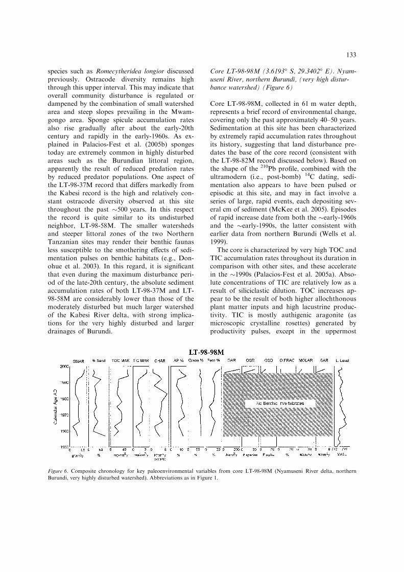
Core LT-98-98M (3.6193� S, 29.3402� E). Nyam-useni River, northern Burundi, (very high distur-bance watershed) (Figure 6)
Core LT-98-98M, collected in 61 m water depth,represents a brief record of environmental change,covering only the past approximately 40–50 years.Sedimentation at this site has been characterizedby extremely rapid accumulation rates throughoutits history, suggesting that land disturbance pre-dates the base of the core record (consistent withthe LT-98-82M record discussed below). Based onthe shape of the 210Pb profile, combined with theultramodern (i.e., post-bomb) 14C dating, sedi-mentation also appears to have been pulsed orepisodic at this site, and may in fact involve aseries of large, rapid events, each depositing sev-eral cm of sediment (McKee et al. 2005). Episodesof rapid increase date from both the �early-1960sand the �early-1990s, the latter consistent withearlier data from northern Burundi (Wells et al.1999).
The core is characterized by very high TOC andTIC accumulation rates throughout its duration incomparison with other sites, and these acceleratein the �1990s (Palacios-Fest et al. 2005a). Abso-lute concentrations of TIC are relatively low as aresult of siliciclastic dilution. TOC increases ap-pear to be the result of both higher allochthonousplant matter inputs and high lacustrine produc-tivity. TIC is mostly authigenic aragonite (asmicroscopic crystalline rosettes) generated byproductivity pulses, except in the uppermost
Figure 6. Composite chronology for key paleoenvironmental variables from core LT-98-98M (Nyamuseni River delta, northern
Burundi, very highly disturbed watershed). Abbreviations as in Figure 1.
133
samples, where some shell material contributes tothe total.
The core displays relatively constant charcoalconcentrations and accumulation rates that grad-ually rise to a peak in the �1980s, probablyreflecting the timing of peak human-inducedburning (Palacios-Fest et al. 2005a). This peak wasfollowed by a sharp decline into the �1990s. Thepattern of increasing charcoal accumulation ratespreceding increased sediment mass accumulationrates, as observed in this core, is also recorded inthe other disturbed sites previously discussed. Thepalynological record shows gradually increasingfern spore abundances after the �1970s, risingsharply in the �1990s (Msaky et al. 2005). Arbo-real and grass pollen concentrations do not varysystematically over this time interval.
For most of the past �50 years, there are nobenthic invertebrate fossils encountered on theNyamuseni River delta record, demonstrating ex-tremely high levels of ecological disturbance,which are almost certainly associated with theextraordinarily high rates of sediment inundationthat invertebrates would experience in this area(Palacios-Fest et al. 2005b). Remotely operatedvehicle (ROV) observations from northern Bu-rundian deltas (Alin et al. 1999) show that thesehabitats are currently dysaerobic, with extremelyunstable and water-rich sediment surfaces at thesediment water interface, as a result of high or-ganic matter concentrations. Invertebrate fossilsoccur only in the late-1990s sediments, comprisinga low diversity assemblage of disturbance-tolerantspecies. However, the high proportions of adult
ostracodes and ostracode carapaces (anomalousfor this water depth) suggest this assemblage maybe transported.
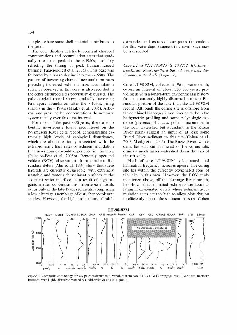
Core LT-98-82M (3.5835� S, 29.3252� E). Karo-nge/Kirasa River, northern Burundi (very high dis-turbance watershed) (Figure 7)
Core LT-98-82M, collected in 96 m water depth,covers an interval of about 250–300 years, pro-viding us with a longer-term environmental historyfrom the currently highly disturbed northern Bu-rundian portion of the lake than the LT-98-98Mrecord. Although the coring site is offshore fromthe combined Karonge/Kirasa river delta, both thebathymetric profiling and some palynologic evi-dence (presence of Acacia pollen, uncommon inthe local watershed but abundant in the RuziziRiver plain) suggest an input of at least someRuzizi River sediment to this site (Cohen et al.2005; Msaky et al. 2005). The Ruzizi River, whosedelta lies �30 km northwest of the coring site,drains a much larger watershed down the axis ofthe rift valley.
Much of core LT-98-82M is laminated, andlamination frequency increases upcore. The coringsite lies within the currently oxygenated zone ofthe lake in this area. However, the ROV studymentioned above, off the Karonge River mouth,has shown that laminated sediments are accumu-lating in oxygenated waters where sediment accu-mulation rates are too high to allow bioturbationto efficiently disturb the sediment mass (A. Cohen
Figure 7. Composite chronology for key paleoenvironmental variables from core LT-98-82M (Karonge/Kirasa River delta, northern
Burundi, very highly disturbed watershed). Abbreviations as in Figure 1.
134
pers. observ.) In fact, the 210Pb profile from coreLT-98-82M shows a remarkable record of sedi-ment accumulation rates increasing 10-fold duringthe late-20th century (McKee et al. 2005), consis-tent with earlier work at the same area (Wells et al.1999). Mass accumulation rates display an earlierepisode of increased rates in about the mid- to late-19th century as well, which declined to much lowerlevels in about the early-20th century before risingagain in the mid-20th century.
Sediment grain size generally decreases upcore,with reversals occurring at times of increasingsediment accumulation rates (Palacios-Fest et al.2005a). TOC concentrations remain relativelyconstant through the core, whereas TIC is low andshows declining values. However, these are largelythe result of background sediment dilution: whennormalized for accumulation rates, both TOC andTIC input per unit time can be seen to havechanged substantially over the core interval,probably the result of rising primary productivityand terrestrial plant debris input. As with the otherterrigenous sediments and charcoal, peak accu-mulation rates occur in about the mid-19th cen-tury and again after �1960, with a notable declinein about the early-20th century. Nitrogen isotoperecords show a trend toward more positive d15Nvalues starting in about the early-19th century,with values consistently indicative of high inputrates of soil nitrogen and/or sewage after that time(O’Reilly et al. 2005).
The commonly observed trend of decreasinggrass pollen, increasing arboreal pollen, andincreasing pteridophyte spores is evident in LT-98-82M, although here the change occurs in theearly-19th century, much earlier than in othercores (Msaky et al. 2005). Starting in about thelate-19th century we observe notable increases inlow-elevation euphorbs, and after about 1930 arise of Myrtaceae pollen, probably from theplanting of many eucalyptus trees in Burundistarting at that time.
Prior to the �1860s a low diversity assemblageof sedimentation-tolerant ostracodes occurs incore LT-98-82M (Palacios-Fest et al. 2005b).However, ostracodes, along with mollusk and fishfossils, are entirely absent from the core record forapproximately the past 140 years. Taphonomicindications in the fossils at the base of the coresuggest that even this assemblage was made up ofreworked fossils and was not a life assemblage
representative of conditions at the time of depo-sition. As with other moderately and highly dis-turbed sites, there is an upcore increase in spongespicule accumulation rates, again contemporane-ous with other rising indications of disturbancesince about the early-19th century for this area ofthe Lake Tanganyika coastline.
Comparisons among coring sites and regions
The cores investigated in this study collectivelyprovide evidence for significant differences in thewatershed environmental history and lacustrineecological response between the various LakeTanganyikan watersheds investigated in our study.Some of these differences are associated withapparent climatic changes, some with local landuse and land cover changes, and some with re-gional patterns of disturbance in the lake’s catch-ment that override the detailed history ofindividual watersheds.
Differences related to climatic change
1. Sediment mass accumulation rates prior to the18th century: Two locations, the Lubulungu andMwamgongo deltas, provide us with pre-18thcentury records covering times of significant cli-matic change. Surprisingly, sediment accumula-tion rates at both appear to be lower duringcentury-scale intervals when climate was morehumid and higher when climate was more arid.However, it is important to note that even thehighest accumulation rates observed during theseapparently climatically driven increases in accu-mulation rates are 3–10 times lower than the ratesencountered in disturbed watersheds during the20th century. Sedimentation rate studies aroundLake Tanganyika also yield variable results withrespect to climate. Elsewhere we have found strongevidence for increasing sediment discharge associ-ated with increased runoff at multidecadal timescales (Cohen et al. 2001). These differences insediment accumulation rate response may belinked to differences in slope, original vegetationtype, or bedrock lithology.2. Charcoal accumulation: We record abundantevidence, in the form of higher charcoal accumu-lation rates, for increased fire activity during the
135

regionally arid, latter portion of the Little Ice Age(16th to early-19th century), consistent with otherregional evidence for aridity at the same time.These patterns occur irrespective of a given wa-tershed’s current disturbance level, and there isconsiderable evidence for recovery from priorintervals of high fire frequency.3. Lake level and water chemistry fluctuations:We observe abundant evidence for changes in lakelevel, manifest in both changing fossil assemblagesand taphonomic indications of relative waterdepth. Lake level fluctuations are linked tohydrologic variability and P/E fluctuations withinthe Lake Tanganyika catchment. However, giventhe size of this catchment (spanning �1–10� S),lake level fluctuations may not be directly linked tolocal climate variability. In fact, we see evidencefrom contrasting lake level vs. local, terrestrialsignals that climate changes have varied in differ-ent parts of the basin. The most likely source ofthis complication is the role of the upstream feederLake Kivu and its catchment, which has episodi-cally overflowed into Lake Tanganyika dependingon precipitation occurring well to the north ofLake Tanganyika. Lake Kivu is similarly impor-tant as a source of dissolved solids for LakeTanganyika today, the system being unusual inthat Lake Kivu is actually more saline and alkalinethan the downstream Lake Tanganyika (Haberyanand Hecky 1987; Cohen et al. 1997). Counterin-tuitively, the closure of Lake Kivu therefore resultsin a solute deficit in Lake Tanganyika and muchlower calcium carbonate availability, both forauthigenic carbonates and the formation/preser-vation of shell-bearing invertebrates.4. Primary productivity changes linked to watercolumn stratification and climate: We see evidencein carbon isotope records from a number of ourcores for a �20% decline in primary productivityof Lake Tanganyika since the early-20th century, atrend that accelerated in the late-20th century(O’Reilly et al. 2003). These stable isotope data areconsistent with instrumental observations of risingtemperatures, declining wind speeds and reducedfish catches over the same time period. We inferthat rising epilimnetic temperatures in LakeTanganyika, along with lower windiness duringthe 20th century, have resulted in more stablestratification of the water column, reducing theupwelling of deep-water nutrients and therebyreducing productivity of the lake.
Differences related to forested vs. deforestedwatersheds
1. Differences in sediment accumulation rates:Rates are much higher at present in the deforestedwatersheds. All deforested watersheds show sharprises in sediment mass accumulation rates, whichcan be temporally linked to other indications ofwatershed disturbance, although, as discussed be-low, the timing of these mass accumulation ratechanges varies between localities. In contrast, allundisturbed watersheds either show constant or, insome cases, declining sediment accumulation ratesover the same intervals.2. Differences in erosional and hydrologicalproducts: Core sediments from highly disturbedsites typically show evidence for profound com-positional changes, such as increased concentra-tions of lateritic soil particles, lamination, andterrestrial plant debris relative to undisturbedsites. Sediments from disturbed watersheds showmore positive d15N isotopic values, and thesevalues increase in a manner consistent in timingwith other indications of disturbance. No suchtrend is observed in the d15N record from theundisturbed LT-98–58M Nyasanga/Kahama site.Modern hydrological studies of disturbed vs.undisturbed watersheds indicates higher propor-tions of groundwater infiltration and evapo-transpiration in forested watersheds, andconversely more rapid discharge, with increasedproportions of overland flow, in deforestedwatersheds. This is manifested in more enrichedd18Owater values in forested watersheds. The lim-ited oxygen isotope data from fossils that grewwithin the zone of hydrologic influence of influentrivers suggests that such enrichment/depletionisotope signals can be transmitted to carbonated18O, resulting in a pattern of falling d18O duringperiods of deforestation.3. Differences in faunal community structure re-lated to sediment inundation: Our results showthat high diversity ostracode assemblages areassociated with low disturbance areas and that lowdiversity assemblages are associated with thehighest levels of disturbance. At the extremes ofdisturbance, as in Northern Burundi, where rela-tively large watersheds discharge vast quantities ofsediment onto broad depositional platforms, thiscan result in apparent extirpation of benthic, del-taic communities. There are clear associations of
136

particular taxa with high disturbance levels, andthese species can be shown to become more com-mon under increasingly disturbed (i.e., with morerapidly accumulating sediment) conditions. One ofour cores, LT-98-18M, shows this transition welland its temporal links with watershed alterations.However, high levels of watershed disturbancemay not translate into signs of community dis-turbance if the watersheds are very small or if thesub-lacustrine slopes are very steep. On theMwamgongo delta, where the watershed is smalland the sublacustrine slope relatively steep, short-term sediment accumulation may be limited byeither total supply or the short-term nature of thestorage. Here the ostracode diversity history differslittle from the nearby paired/undisturbed delta ofthe Nyasanga and Kahama rivers. Although it isclear from the work of O’Reilly (2001), Alin et al.(2002) and others that the shallow lacustrinecommunities and ecosystems at Mwamgongo arequalitatively different from those of nearby areasinside of Gombe Stream National Park, it is lessclear that these littoral impacts translate into ma-jor effects in deeper water downslope (at our cor-ing sites). In this regard, it may be significant thatsponge spicule accumulation rates are stronglycorrelated with disturbance levels for all sites. Asexplained by Palacios-Fest et al. (2005b), thisseemingly counterintuitive result is probably bestexplained by a decline in top-down predation ratesin highly disturbed deltas, where littoral, inverte-brate-grazing fish populations are significantlydiminished.
Differences related to regional patterns ofdeforestation-palynological profiles
The timing of transition to greatly elevated fernspore abundance, our most unambiguous evidencefor disturbance, varies between regions of thelakeshore. The earliest evidence for this rise is innorthern Burundi, where fern abundance risessignificantly starting in about the late-18th cen-tury. In northernmost Tanzania, the rise begins inabout the late-19th century. Moving farther south,the Nyasanga/Kahama River (undisturbed site)core records this shift in about the early-20thcentury, and the Kabesi River (central Tanzania)records the shift in about the mid-20th century.The Lubulungu River undisturbed site, oursouthernmost locality, does not show a significant
rise in fern spores above background levels up tothe present. It is noteworthy that this signal ofdisturbance is evident in the Nyasanga/Kahamarecord, despite the modern protected status of thiswatershed. This suggests both a regional advancein disturbance from north to south over the past�250 years and a spatial averaging of readilytransported components of the record, such as fernspores, that blankets local differences in the historyof smaller watersheds. Low-elevation euphorbs,which are also common in disturbed areas, show asimilar historic and geographic pattern to theferns.
The most puzzling results of our palynologicalinvestigations are the trends towards increasedarboreal pollen and decreased grass pollen overthe last few centuries. The diachronous timing ofthis pattern is broadly similar to that of fern sporeincreases (i.e. earlier in the north). These findingsare counterintuitive given that all other indica-tions of landscape alteration point toward moreerosion and presumably less forest cover, startingin about the late-18th to early-19th century in thenorth of the Lake Tanganyika catchment andsweeping south over time. As discussed by Msakyet al. (2005), a likely explanation of this findingcomes from the observation that most subsistencefarming systems adopted in the region after landis cleared involve the initial replacement of low-elevation grassy Miombo woodlands with welltended but unterraced hillslope farming of cas-sava and valley bottom production of bananasand oil palm. None of these replacement cropsgenerate abundant pollen. Goats, which are amajor part of the post-deforestation landscape,and are allowed to roam freely in most farmareas, probably consume most grasses before theyflower, limiting grass pollen production. Thus,pollen rain in post-deforestation landscapeswould be increasingly dominated by wind-blownarboreal pollen derived from remaining, forested,high mountain areas in the region. A secondlikely source of arboreal pollen in post-distur-bance records is the eroded soil itself, whichwould provide a reservoir of pollen grains domi-nated by tree species while the living sourcesthemselves are depleted.
One notable and major exception to the north tosouth trend in arboreal and grass pollen propor-tional changes comes from the southernmost area,the Lubulungu Delta, on the west side of the
137

Mahale Mountains. This undisturbed site (coreLT-98-12M) records a gradual and long-term de-cline in grass pollen and increase in arboreal pollenstarting in about the 18th century. This site isunique in that it is the only place where thistransformation is not accompanied by rising fernspore abundance. This watershed today alsoexperiences the highest precipitation of any studiedregion (�1600–1800 mm yr�1 vs. �1000–1200 mmyr�1 for all other areas at the lakeshore elevation).Given these observations, the most likely expla-nation of the long-term palynological trend at LT-98-12M is that it reflects the actual conversion ofthe landscape from a drier, woodland conditionduring the latter Little Ice Age to the evergreen-forested landscape that occurs in the westernMahale Mountains today.
Differences related to interactions of deforestationand climate effects – Sediment accumulation rates,charcoal, palynology and lake faunal responseassociated with the early-1960s event
One of the truly striking features of our combinedrecords is the coincidence of changes in numerousvariables indicating accelerated disturbance afterabout the early-1960s. The pattern is observed inall disturbed locality cores. With the exception ofpalynological and charcoal indicators at the Nya-sanga/Kahama site, which arguably representlonger distance transport by flotation or wind,these signals are also absent in all undisturbedsites. Two hypotheses can be forwarded for thistiming. First, it is possible that some regionalchange in land-use patterns occurred at that time,perhaps associated with the end of colonial rule,which dates approximately from this era. Thisexplanation seems unlikely to us, since there are nohistorical records of such a change occurring, andsince the land-use and tenure systems varied con-siderably between Tanzania and Burundi, despitethe fact that the pattern is observed in cores fromboth countries.
A more likely explanation of the patterninvolves a combination of climatic and anthro-pogenic causes. 1961 was a record wet year inEast Africa (Nicholson 1999), with high waterlevels recorded in almost all lakes and gaugingstations, as illustrated by the lake level curve inFigure 6. Although the sustained mid-20th
century increase in sediment accumulation rates isultimately a likely consequence of increased ero-sion rates on cleared farmland, it is uncertain howefficiently or quickly this sediment is delivered toLake Tanganyika. Soil erosion rates were proba-bly accelerating during the early- to mid-20thcentury in many heavily populated watersheds ofthe northern Lake Tanganyika catchment as aresult of both rising human populations and theexpansion of cassava cultivation (G. Maddoxpers. comm. 2004). The latter development maybe of particular importance since cassava is one ofthe few crops that can be effectively raised on thevery steep slopes common to many Lake Tang-anyika watersheds, and based on experimentalstudies in the region its planting is known togenerate extraordinary acceleration in soil erosion(Bizimana and Duchafour 1991). Although it is astaple in the region today it was apparently not animportant crop prior to the early 20th century.However, much of the sediment generated by lo-cal hillslope erosion goes into temporary alluvialstorage in river valleys, and we do not see agradual rise through the early 20th Century insedimentation arriving at the lake but rather anabrupt change many years after cropping prac-tices had begun to change. This suggests that a‘triggering mechanism’ was required to stimulatesediment delivery to the lake. Extraordinaryrainfall events are known to have such effects onalluvium, incising head cuts in soft alluvial sedi-ments that propagate themselves upstream afterthe initial incisions are made. Greatly increasedlandslide activity occurred during the most recentstrong ENSO wet season (1997/98) in the defor-ested watersheds around Lake Tanganyika,apparently the result of very rapid infiltrationalong exposed fault and gouge surfaces. Thissuggests that several mechanisms may link climatetriggers to increased susceptibility of higher sedi-ment discharge in deforested areas. Thus, acombination of anthropogenic and climate forc-ing is the most likely explanation for the coinci-dence of the early-1960s timing of acceleratedsediment accumulation rates and the developmentof the unprecedented (for the past �300–400 years) rates of sedimentation observed alongmuch of the northeastern Lake Tanganyikacoastline today. This type of sediment storagemay also help explain the lag of up to severaldecades between rising charcoal accumulation
138

rates and terrigenous sediment accumulation ratesthat we observe in a number of our cores fromdisturbed sites.
Discussion
The results of this mulit-disciplinary study providestrong support for climate change, human activity,and the interactions between climate and land use,as driving mechanisms explaining the environ-mental history of the Lake Tanganyika catchmentover the past millennium. Climatic controls aremost strongly expressed in evidence for varyinglake levels and extent of aridity, particularly forthe arid latter part of the Little Ice Age and thetransition to wetter climate conditions in the mid-19th century. Climate effects are manifested asnear-synchronous events over the geographic scaleof coverage of this study (�300 km north tosouth). However, lake-level fluctuations are de-coupled from ‘local’ climate variability because ofthe strong influence that the northern portion ofthe Lake Tanganyika catchment, around LakeKivu, can have on the Lake Tanganyika waterbudget. Our data imply that climate histories inthe Kivu catchment may not be completely syn-chronous with those farther south, around theLake Tanganyika coring sites.
Evidence for human-induced deforestation andits ecological consequences within Lake Tang-anyika implies much earlier deforestation in theBurundian and northern Tanzanian coastal re-gions of the lake than along the central Tanzaniancoast. This is consistent with what is known of thedemographic history of human settlement in thestudy regions prior to the colonial period. Lin-guistic evidence points to a long history of well-defined cultural groups, and probably relativelyhigh human population densities in what are nowBurundi and northern Tanzania, probablystretching back at least several millennia(Schoenbrum 1998; Chretien 2003). Archaeologi-cal data from many of these areas provides strongevidence that human-induced deforestation waswidespread starting as early as �2500 years ago,primarily associated with demands for charcoalfrom iron production (e.g. Schmidt 1997).
Oral histories show that centralized rule under along series of Burundian kings was established bythe late-17th century (Lemarchand 1970; Chretien
2003). More localized kingdoms were establishedin the Buha region of what is now northern Tan-zania (the Kalinzi/Ujiji area) by the early- to mid-19th century (McHenry 1980; Wagner 1996 andpers. comm.) (Figure 8a). Records for the MahaleMountains region are extremely limited but thelow population densities of this area today, cou-pled with its general remoteness from lines oftrade, suggest it was probably sparsely inhabitedduring the 18th and 19th centuries. The first or-ganized caravans for slaves and ivory tradereached the Lake Tanganyika shoreline in the1830s, probably exploiting older salt tradingroutes (Koponen 1988) (Figure 8b). The terminusfor this trade at the lakeshore was either the Ujiji/Kalinzi area of northern Tanzania (just south ofmodern Kigoma) or slightly to the south, near theMalagarasi River mouth. The caravan trade wasfacilitated in the Kalinzi–Ujiji area by the agree-ments with the local mwami (king) (Wagner 1996)creating an important route for the rapid trans-mission of disease, especially cholera and smallpoxepidemics, across Tanzania at this time. Theseepidemics led to a significant decline in humanpopulation in much of western Tanzania duringthe early- to mid-19th century (Koponen 1988). Bythe 1860–1890s, ivory trading, and therefore ele-phant depopulation, reached its peak in westernTanzania.
The combination of rampant disease, the effectsof major reductions in elephant populations, slaveraiding, and the widespread famines reported inwestern Tanzania from the 1860–1870s, all wouldhave hastened the expansion of forest cover in lesssettled areas (Stanley 1878; Koponen 1988).Although slavery was legally outlawed in Zanzibarin the 1870s, the slave trade continued in theeastern Congo, and caravans continued to crossLake Tanganyika to Ujiji until at least the late-1880s. In fact, slaves were acquired in greatnumbers by the Kalinzi mwami and his clans, tothe extent that by the late 1880s, the majority ofthe inhabitants of Ujiji were slaves (Koponen1988). Human population probably rose locally inthe immediate vicinity of Ujiji and the LuicheRiver valley, as slaves were gathered from theeastern Congo to help in agricultural productionnecessary to support the western caravan routes(G. Maddox pers. comm. 2004). Stanley’s (1878)accounts suggest a population in Ujiji proper at3000 in 1878 and 36,000 in the Luiche River valley
139

hinterland (�15 people/km2). Unfortunately we donot have any paleolimnological records from thisarea to determine the timing of deforestation inthat watershed. However, Stanley reported thatareas only a few tens of kilometers away from Ujijiwere heavily forested at the same time. Control by
the Buha mwamis extended north along the Tan-zanian coast as far as the Nyasanga/Kahama area.It is significant for this study that Nyasanga wasthe frontier of Buha territory at this time (Burton1860). Mwamgongo, just a few kilometers to thenorth, was under the control of Burundian princes
Figure 8. Summary maps of demographic and environmental history around northern Lake Tanganyika. Letters on maps indicate
coring areas A: Lubulungu R. delta (LT-98-2M and 12M); B: Kabesi R. delta (LT-98-18M); C: Malagarasi R. delta (LT-97-14V); D:
Nyasanga/Kahama and Mwamgongo R. deltas (LT-98-58M and 37M); E: Nyamuseni and Karonge/Kirasa R. deltas (LT-98-98M and
82M). Arrows indicate the approximate location and relative scale of enhanced sedimentation inputs to Lake Tanganyika and
associated ecological impacts. Lines along the Burundi and northern Congo coastline in panels C and D indicate expanding road
network.
140

(ganwas), who strongly discouraged contact withoutsiders, especially the caravan traders.
Early European explorers in the region reportnumerous local wars, abandoned villages, andother evidence of depopulation during the mid-late19th century (Bennett 1970; Koponen 1988), andby the 1880s, when the first Catholic missions wereestablished along the Tanzanian coast of LakeTanganyika, even Ujiji appears to have been lar-gely depopulated (Koponen 1988). Overall, evi-dence points to a stagnating or locally declininghuman population throughout the central coast-line regions of Tanzania through the late 19thcentury, culminating in devastating human andlivestock population declines with the Rinderpestoutbreak of the 1890s. The regional trend ofpopulation was not truly reversed until about the1930s (Koponen 1996) (Figure 8c). More remoteareas further south, such as our study area, theKabesi River valley on the north coast of theMahale Mountains, were probably never settled inlarge numbers during the 18th and 19th centuries.These areas experienced rising human populationseven later in the 20th century.
In contrast, the Burundian watersheds feedingLake Tanganyika were occupied by a populationthat, during the 18th to early-19th centuries, wascoming under increasing control of the highlandkings, culminating with the accession to power ofMwami Ntare in the 1850s (Lemarchand 1970;Gahama 1983). Areas along the Lake Tanganyikacoast in Burundi were probably only indirectlycontrolled by the mwami, either through networksof local ganwa, or by non-ganwa chiefs allied withthe mwami (Mworoha 1977). But the net result wasa hierarchichal rule that could exert control, eitherdirectly or indirectly, over large areas, greatlyreducing interaction with the coastal caravantraders. Although some Swahili caravan settle-ments existed in a few locations along the Burundicoast, these traders were effectively blocked frompenetrating into the heavily settled hinterlands ofBurundi, where the highest population densities inwatersheds like the Karonge, Kirasa and Nyamu-seni would have resided (Chretien 2003). This, inturn, may have insulated these people during mostof the 19th century from the depopulating effects ofimported disease and slave raiders. Certainly, asmentioned above, caravan traders were stronglydiscouraged, or even attacked, when they tried toland along the ‘Burundian’ coast, anywhere north
of Nyasanga up to the Rusizi River (Burton 1860).The earliest European missionaries who attemptedto settle along the Burundi coast (at Rumonge)were killed in 1881 (Lemarchand 1970). As a result,there are no written accounts from Europeanexplorers or Arab traders of the Burundian coast-line from the early to mid-19th century. However,when the Austrian explorer Oskar Bauman visitedthe Burundian coastal region in 1892, he alreadynoted very dense human populations and extensivedeforestation (Gahama 1983). The much earlierestablishment of indirect control by the Burundianmwamis, and the exclusion of the caravan trade,with its many vectors of human depopulation, allsuggest that high population density and defores-tation were features of the Burundian and north-ernmost Tanzanian landscape long before theseconditions existed along the west-central Tanza-nian coast. This is consistent with the generaltiming of our records of watershed disturbancefrom both Mwamgongo and the northern Burundiwatersheds.
At the very end of the 19th and during the early-20th centuries, regional outbreaks of human andcattle diseases (especially the infamous Rinderpestoutbreak) affected much of central Africa. Thisresulted in massive depopulation in many formerlyheavily populated areas such as Burundi, andhastened the decline in Tanzania. For example, itis estimated that Burundi did not attain the samepopulation it had in the 1880s (�2 million) until1950 (Chretien 2003). It is noteworthy, therefore,that our single long sediment record from northernBurundi shows a major decline in deforestationand land disturbance indicators between the la-te19th through the mid-20th centuries.
Numerous records indicating an acceleration ofwatershed disturbance throughout the disturbedBurundian and Tanzanian study areas since themid-20th century are also consistent with regionaldemographic trends. A lakeshore road running thelength of the Burundian coastline was first con-structed in the 1920s (Gahama 1983). This roadfacilitated human resettlement, development oflarge-scale agriculture along the coastal plain, andwoodcutting throughout the coastal watersheds, allof which must have generated substantial new landdisturbance. Furthermore, road construction itselfis thought to generate enhanced sediment dischargein the Lake Tanganyika catchment (Donohue et al.2003). By the 1930s population densities in the
141

Bujumbura area had reached about 45 people/km2
(Gahama 1983). As discussed earlier, it may also besignificant that cassava production does not appearto have been widespread in the region until theearly-mid 20th century (McCurdy 2000; G. Mad-dox pers. comm. 2004). For example, in descrip-tions of Ujiji market trade in the mid 1870s, Stanley(1878) noted that cassava was an imported productfrom what is now the Congo (across Lake Tang-anyika) and was not grown in what is now northernTanzania or Burundi in significant quantities.Cassava is one of the few crops that can be suc-cessfully grown on very steep and nutrient-depletedsoils in this region, and its successful introductioninto the local economy may have accelerated soilerosion from steeply sloping areas, which hadpreviously been unprofitable for farming. Itsexpansion as a food crop in Burundi was particu-larly promoted by the British and Belgian colonialauthorities after the 1920s (M. Wagner pers.comm. 2004). However, the largest sedimentaccumulation rate increases in nearshore deltaicenvironments occurred in both Burundi and Tan-zania after the 1950s Lemarchand 1970; Koponen1996; Maddox 1996). By the early-1960s, when weobserve the widespread spike in sediment accu-mulation rates, deforestation was probably wide-spread throughout much of the Burundian andnorthern Tanzanian coastline. Excess sedimentthat had accumulated in deforested alluvial valleysthroughout the region would have been readilyavailable for secondary erosion into Lake Tang-anyika following the extraordinary floods of 1961(Figure 8d).
In addition to documenting the timing of ter-restrial changes in deforestation around LakeTanganyika, our other goal in this project was tointerpret the lake’s ecological responses to theseinferred disturbances. Our data suggest that theremay be predictable linkages between landscapedisturbance and lake ecological response that haveimportant implications for how Lake Tanganyikaand its catchment are managed.
First, the pattern of rapid local extinction andincrease in the abundance of a small number ofsedimentation-tolerant species we observe in theLT-98-18M record through the disturbance inter-val is consistent with earlier ecological models ofLake Tanganyika endemic species distributionbased on modern observations (Cohen 2000; Mi-chel et al. 2004). These models suggest that the
‘populations’ of many endemic invertebrates areactually organized as ‘metapopulations’, with ex-tremely patchy and disjunct distributions of rela-tively small local populations. The long-termviability of these metapopulations may be depen-dent on regular recolonization of appropriatehabitats by nearby founder populations. If excesssedimentation along major segments of the coast-line becomes a barrier to recolonization to sedi-ment-intolerant species, then population-level (andultimate species-level) extinction can occur. Thisimplies that lake conservation management strat-egies should strive to reduce sediment impactsalong lake shore margins which are long enough toencompass multiple founder populations of thetarget species for conservation.
Second the northern Burundian coastline, wherewe observe the most severe impacts, has probablybeen particularly susceptible to sedimentation-generated disturbance because it experiences twoaggravating factors. First, watersheds are rela-tively large, and thus capable of delivering largequantities of sediment to what are effectivelypoint-source outlets (delta distributary dischargepoints), even if no disturbance were occurring.Second, underwater slopes along the Burundicoast are relatively gentle, encouraging short-termstorage and accumulation. If the Rusizi River hasbeen a long-term contributor to the sedimentbudget of the northeast part of the lake, it is pre-dictable that this slope factor would become moreaggravated as one moves further north in this re-gion, whereas the watershed area factor would bemore variable. If this hypothesis of enhanced vul-nerability is correct, then particular attentionshould be paid to geomorphically similar parts ofthe lake basin which have not yet experienced suchpervasive settlement, road construction and culti-vation, particularly at the south end of the lakeand on the major platform regions (South Mala-garasi, in the Halembe area and the Ikola Plat-form). Mitigating problems associated withaccelerated erosion in such areas will be a dauntingchallenge if they become highly disturbed in thefuture.
Conversely, the threats to lake systems areprobably reduced in areas of steep slopes and smallwatersheds. Places like the Mwamgongo watershedare unlikely to generate the quantities of sedimentrequired to impact large areas, and enhancement ofsediment storage in the sublittoral zones may be
142

relatively subdued or non-existent. Donohue et al.(2003) have argued that deforestation of ‘small’watersheds around Lake Tanganyika may pose amuch greater risk than large ones, in contradictionto what we suggest here and what one of us hasargued elsewhere (Cohen et al. 1993b). Their study,based on a paired drainage comparison of theKalambo River (2980 km2) vs. the Lunzua River(1015 km2) watersheds, indicated approximately 5-fold higher sediment yields in the smaller wa-tershed, which they attribute largely to greatersediment retention capacities of larger watersheds.The 10-fold higher road density in the smaller wa-tershed (measured as road meters/km2 watershedarea) makes a comparison of the two watershed’sbehaviors difficult to compare as a function ofwatershed size difficult. Furthermore, the size ofboth of these watersheds is actually quite large incomparison with the types of watersheds we arereferring to as ‘small’ in this study (i.e. under10 km2). The latter type of watershed is extremelyabundant along themajor border fault escarpmentsof Lake Tanganyika, and it is these types ofdrainages that we would argue pose a lesser threatto lacustrine biodiversity when they becomedeforested. Clearly threats will exist in front of suchwatersheds to the littoral zones directly adjacent tothe river discharge point when erosion rates accel-erate, as shown by our Mwamgongo River data.However, these problems must be placed in contextwith the far more serious threats posed by distur-bance in the more vulnerable large watersheds andgently sloping regions of the lake. An historicalapproach, such as we have taken here, demon-strates that it is precisely the large sediment reten-tion capacity of larger, flatter watersheds that canmake such areas vulnerable to massive sedimentdischarges when alluvium is remobilized by down-cutting following extreme precipitation events.
Summary
Paleolimnological investigations of the LateHolocene history of Lake Tanganyika, Africaprovide a record of the interactive impacts ofhuman activities and climate change on the lakeand its surrounding catchment. Our multidisci-plinary studies of sediment accumulation rates,sedimentology, lacustrine paleoecology, palynol-ogy, organic and inorganic isotope geochemistry
and hydrology demonstrate that strong historicaldifferences exist between histories of currentlydisturbed and undisturbed watershed histories.Furthermore these differences can be interpretedin light of differences in the human demographicand environmental histories of Burundi and wes-tern Tanzania. In some areas, notably the north-ern watersheds of the lake, evidence of extensivedeforestation greatly precedes the major popula-tion increases of the 20th century. However, sev-eral 20th century events probably played pivotalroles in accelerating the rate of soil erosion andcausing erosional products to inundate manynearshore regions of the lake. These events includethe large scale expansion of cassava cultivation(which can be grown on very steep and easilyerodable slopes), starting in the early part of the20th century, the expansion of lake-margin roadconstruction in Burundi, and the extraordinaryrainfall events of the early 1960s, which acceler-ated the delivery of previously trapped alluviuminto the deltas of heavily impacted watersheds.Climatic events (arid-wet cycles) and lake levelfluctuations prior to the 19th century also influ-enced sediment accumulation rates, palynologyand lacustrine paleoecology However the magni-tude of these effects was well below what isobserved from the 20th century.
The impacts of these greatly increased sedimentaccumulation rates along the shorelines of defor-ested watersheds are evident from the lacustrinepaleoecological records of our core sites. Declinesin the diversity of rare species, or even wholesaleelimination of significant portions of the lacustrinebiota are apparent from the ostracode crustaceanrecords of moderately to very highly impactedwatersheds. We also observe evidence for top-down ecological impacts at heavily impacted deltasin the expansion of sponges whose abundances arenormally controlled by grazing fish.
Our findings provide strong implications forfuture environmental management and conserva-tion strategies at Lake Tanganyika and its catch-ment. We observe rapid (decadal time scale) localextinction of invertebrate species from heavilysedimented portions of the lake’s littoral zone.This observation, coupled with earlier evidencethat many species of fish and invertebrates in LakeTanganyika have patchy distribution patterns, andare probably organized as loosely interactingmetapopulations, suggests that conservation
143

strategies for the lake’s extraordinary biota mayrequire significant interconnectedness betweenunimpacted stretches of the coastline in order to beeffective in forestalling endemic species extinction.Our comparative data of impacts at watersheds ofvarying size also suggests that large watershedsfeeding onto relatively gently sloping lake floorareas are the zones of the lake at greatest risk fromsedimentation impacts. Watershed managementstrategies whose primary goal is protectionof Lake Tanganyika’s lacustrine biodiversityshould pay particular attention to areas such asthe southern Zambian coastline or the southMalagarasi and Ikola platforms of the lake, whichhave these types of geomorphic characteristics, butwhose watersheds are still relatively lightlypopulated.
Acknowledgments
We thank the Lake Tanganyika Biodiversity Pro-ject (LTBP) for major funding for this research,and especially the assistance of Drs Andy Menz,Graeme Patterson and Kelly West of LTBP forfacilitating the work described here. Additionalfunding came from the US National ScienceFoundation (NSF Grant #s EAR 9510033, ATM9619458 and ATM 0223920). We also thank GregMaddox, John Smol and Bill Last, who all readand critiqued earlier drafts of this manuscript andAnthony Collins, for freely sharing his insight andknowledge of recent environmental history of theLake Tanganyika coastline. This is contribution#172 of the International Decade of East AfricanLakes (IDEAL).
References
Alin S.R. and Cohen A.S. 2003. Lake-level history of Lake
Tanganyika, East Africa, for the past 2500 years based on
ostracode-inferred water-depth. Palaeogeogr. Palaeoclimatol.
Palaeoecol. 199: 31–49.
Alin S.R., Cohen A.S., Bills R., Gashagaza M.M., Michel E.,
Tiercelin J.J., Martens K., Coveliers P., Mboko S.K., West
K., Soreghan M., Kimbadi S. and Ntakimazi G. 1999. Effects
of landscape disturbance on animal communities in Lake
Tanganyika. Conserv. Biol. 13: 1017–1033.
Alin S.R., O’Reilly C.M., Cohen A.S., Dettman D., Palacios-
Fest M. and McKee B. 2002. Effects of land-use change on
aquatic biodiversity: a view from the paleorecords at Lake
Tanganyika, East Africa. Geology 30: 1143–1146.
Bennett N.R. (ed.) 1970. Stanley’s Despatches to the New York
Herald, 1871–1872, 1874–1877. Boston University Press,
Boston 508 pp.
Birkett C., Murtugudde R. and Allan T. 1999. Indian Ocean
climate event brings floods to East Africa’s lakes and the
Sudd Marsh. Geophys. Res. Lett. 26: 1031–1034.
Bizimana M. and Duchafour H. 1991. A drainage basin
management study: The case of the Ntihangwa River Basin.
In: Cohen A.S. (ed.), Report of the First International
Conference on Conservation and Biodiversity of Lake
Tanganyika. Biodiversity Support Program, Washington,
DC, pp. 43–45.
Burton R.F. 1860. (1995 Dover reprint). The Lakes Regions of
Central Africa. Harper Bros, NY, 572 pp.
Chretien J.-P. 2003. The Great Lakes of Africa, Two Thousand
Years of History. Zone Books, NY, 503 pp.
Clutton-Brock T.H. and Gillett J.B. 1979. A survey of forest
composition in the Gombe National Park, Tanzania. Afr. J.
Ecol. 17: 131–158.
Cohen A.S. (ed.) 1991. Report on the First International
Conference on the Conservation and Biodiversity of Lake
Tanganyika. Biodiversity Support Program, Washington,
DC, 128 pp.
Cohen A.S. 2000. Linking spatial and temporal changes in the
diversity structure of ancient lakes: Examples from the ostra-
cod ecology and paleoecology of Lake Tanganyika. In: Ross-
iter A. and Kawanabe H. (eds), Ancient Lakes: Biodiversity,
Ecology and Evolution. Advances in Ecological Research,
Vol. 31. Academic Press, San Diego, CA, pp. 521–537.
Cohen A.S., Bills R., Cocquyt C. and Caljon A.G. 1993b. The
impact of sediment pollution on biodiversity in Lake Tang-
anyika. Conserv. Biol. 7: 667–677.
Cohen A.S., Palacios-Fest M.R., McGill J., Swarzenski P.,
Verschuren D., Sinyinza R., Songori T., Kakagozo B.,
Syampila M., O’Reilly C.M. and Alin S.R. 2005. Paleolim-
nological investigations of anthropogenic environmental
change in Lake Tanganyika: I. An introduction to the pro-
ject. J. Paleolimnol. 34: 1–18.
Cohen A.S., Soreghan M.J. and Scholz C.A. 1993a. Estimating
the age of formation of lakes: an example from Lake Tang-
anyika. Geology 21: 511–514.
Cohen A., Kaufman L. and Ogutu-Ohwayo R. 1996. Anthro-
pogenic threats, impacts and conservation strategies in the
African Great Lakes – a review. In: Johnson T. and Odada E.
(eds), The Limnology, Climatology and Paleoclimatology of
the East African Lakes. Gordon and Breach Publishers,
Newark, N.J, pp. 575–624.
Cohen A.S., Lezzar K.E., Cole J.E., Dettman D.L., Eagle M.,
Michelo V., Zilifi D., Chororoka K., Plisnier P.D. and Ellis
G. 2001. Paleolimnologic evidence for decadal to centurial
scale climate and productivity linkages in Lake Tanganyika.
EOS Trans. Suppl. 82: F759.
Cohen A.S., Talbot M.R., Awramik S.M., Dettman D.L. and
Abell P. 1997. Lake level and paleoenvironmental history of
Lake Tanganyika, Africa, as inferred from late Holocene and
modern stromatolites. Geol. Soc. Am. Bull. 109: 444–460.
Coulter G.W. 1991. Lake Tanganyika and its Life. Oxford
University Press, 354 pp.
Dettman D., Palacios-Fest M.R., Nkotagu H.H. and Cohen
A.S. 2005. Paleolimnological investigations of anthropogenic
environmental change in Lake Tanganyika: VII. Carbonate
144

isotope geochemistry as a record of riverine runoff.
J. Paleolimnol. 34: 93–105.
Donohue I., Duck R.W. and Irvine K. 2003. Land use, sedi-
ment loads and dispersal pathways from two catchments at
the southern end of Lake Tanganyika, Africa: implications
for lake management. Environ. Geol. 44: 448–455.
Evert M.J. 1980. Le lac Tanganyika, sa faune, et la peche au
Burundi. Thesis Universite du Burundi, Bujumbura.
Gahama J. 1983. Le Burundi sous adminstration Belge. Edi-
tions Karthala, Paris, 465 pp.
Haberyan K.A. and Hecky R.E. 1987. The late Pleistocene and
Holocene stratigraphy and Paleolimnology of Lakes Kivu
and Tanganyika. Palaeogeogr. Palaeoclimatol. Palaeoecol.
61: 169–197.
Jolly D. and Bonnefille R. 1992. Histoire et dynamique du
marecage tropical de Ndurumu (Burundi), donnees polli-
niques. Revue Palaeobot. Palynol. 75: 133–151.
Koponen J. 1988. People and production in late precolonial
Tanzania. Monogr. Finn. Soc. Ofr Devel. Studies 2, 434
pp.
Koponen J. 1996. Population, a dependent variable. In: Mad-
dox G., Giblin J. and Kimambo I.N. (eds), Custodians of the
Land, Ecology and Culture in the History of Tanzania. Ohio
University Press, pp. 19–42.
Lemarchand R. 1970. Rwanda and Burundi. Praeger Publish-
ers, New York, 562 pp.
Lowe-McConnell R.H., Crul R.C.M. and Roest F.C. (eds)
1992. Symposium on Resource Use and Conservation of the
African Great Lakes, Bujumbura 1989. Soc. Int. Limnol.
Mitt. v. 23.
Maddox G. 1996. Environment and population growth. In:
Maddox G., Gilpin J.L. and Kimambo I.N. (eds), Custodians
of the Land. Ohio University Press, pp. 43–65.
McCurdy S.A. 2000. Transforming associations: fertilities,
therapy, and the Manyema Diaspora in urban Kigoma,
Tanzania, c. 1850–1993. Ph.D. Dissertation, Columbia Uni-
versity.
McKee B., Cohen A.S., Dettman D.L., Palacios-Fest M.R.,
Alin S.R. and Ntungumburanye G. 2005. Paleolimnological
investigations of anthropogenic change in Lake Tanganyika:
II. Geochronologies and mass sedimentation rates based on14C and 210Pb data. J. Paleolimnol. 34: 19–29.
McHenry D.E. 1980. Reorganization: an administrative history
of Kigoma District. Tanzania Notes Records 84/85: 65–74.
Michel E., Todd J.A., Cleary D.F.R., Kingma I., Cohen A.S.
and Genner M.J. 2004. Scales of endemism: challenges for
conservation and incentives for evolutionary studies in a
gastropod species flock from Lake Tanganyika. J. Conchol.
Sp. Publ. 3: 155–172.
Msaky E.S., Livingstone D. and Davis O.K. 2005. Paleolim-
nological investigations of anthropogenic change in Lake
Tanganyika: V. Palynological evidence for deforestation and
increased erosion. J. Paleolimnol. 34: 73–83.
Mworoha E. 1977. Peuples et rois de l’Afrique des lacs. Abid-
jan, Dakar.
Nicholson S.E. 1998. Historical fluctuations of Lake Victoria
and other lakes in the northern rift valley of East Africa. In:
Lehman J.T. (ed.), Environmental Change and Response in
East African Lakes. Kluwer Academic Publishers, Dordr-
echt, pp. 7–36.
Nicholson S.E. 1999. Historical and modern fluctuations of
Lakes Tanganyika and Rukwa and their relationship to
rainfall variability. Climatic Change 41: 53–71.
Nkotagu H.H. 2005. Paleolimnological investigations of
anthropogenic environmental change in Lake Tanganyika:
VIII.Hydrological evaluationof twocontrastingwatershedsof
the Lake Tanganyika catchment. J. Paleolimnol. 34: 107–123.
O’Reilly C.M. 2001. The Effects of Land Use Change on Lit-
toral Zone Dynamics of Lake Tanganyika, East Africa.
Ph.D. dissertation University of Arizona, 144 pp.
O’Reilly C.M., Alin S.R., Plisnier P.D., Cohen A.S. and McKee
B.A. 2003. Climate change decreases aquatic productivity of
Lake Tanganyika, Africa. Nature 424: 766–768.
O’Reilly C.M., Dettman D.L. and Cohen A.S. 2005. Paleo-
limnological investigations of anthropogenic environmental
change in Lake Tanganyika: VI. Geochemical indicators. J.
Paleolimnol. 34: 85–91.
Palacios-Fest M.R., Cohen A.S., Lezzar K.E., Nahimana L.
and Tanner B.M. 2005a. Paleolimnological investigations of
anthropogenic environmental change in Lake Tanganyika:
III. Physical stratigraphy and charcoal analysis. J. Paleo-
limnol. 34: 31–49.
Palacios-Fest M.R., Alin S.R., Cohen A.S., Tanner B. and
Heuser H. 2005b. Paleolimnological investigations of
anthropogenic environmental change in Lake Tanganyika:
IV. Lacustrine paleoecology. J. Paleolimnol. 34: 51–71.
Schmidt P.R. 1997. Archaeological views on a history of
landscape changes in East Africa. J. Afr. History 38: 393–421.
Schoenbrun L. 1998. A Green Place, A Good Place. Agrarian
Change, Gender and Social Identity in the Great Lakes Re-
gion to the 15th Century. Heinemann Publishers, Ports-
mouth, NH, 302 pp.
Stanley H.M. 1878. Through the Dark Continent v. 2. Harper
and Bros. Publishers, 566 pp.
Van Alstine J.M. and Cohen A.S. 2003. Nyanza Project re-
search on the relationship of ostracode abundance and
taphonomy to environmental variables on the Luiche Delta
Platform, Lake Tanganyika. Amer. Soc. Limnol. Oceanogr.
Ann Mtg, Salt Lake City, UT, abstr. w/prog, 132 pp.
Verschuren D., Laird K.R. and Cumming B.F. 2000. Rainfall
and drought in equatorial East Africa during the past
1100 years. Nature 403: 410–414.
Wagner M. 1996. Environment, community and history,
‘‘nature in the mind’’. In: Maddox G., Gilpin J.L. and Ki-
mambo I.N. (eds), Custodians of the Land. Ohio University
Press, pp. 175–199.
Wells T.M., Cohen A.S., Park L.E., Dettman D.L. and McKee
B.A. 1999. Ostracode stratigraphy and paleoecology from
surficial sediments of Lake Tanganyika, Africa. J. Paleolim-
nol. 22: 259–276.
145