page number : 1 - oregon.gov home page · sign code, the downtown awning program, and state...
TRANSCRIPT

Following are pages that show all plan amendments adopted by the county and the cities in the county and submitted to DLCD since January of 1987. The list shows the county amendments first and then the cities alphabetically. Within a jurisdiction the amendments are sorted by adoption date with the older ones first. Page numbering returns to page 1 with each city.
For each amendment the first line includes the name of the jurisdiction, local file number, DLCD file number, local adoption date and any LUBA case number for those amendments that were appealed to LUBA. We have not provided information on LUBA decisions, but provide the case number to indicate that the amendment was appealed.
Below the amendment identification information are descriptions labeled "Proposed Desc." and "Adopted Desc." The Proposed Description is a more complete description of the amendment as it was proposed amendment and submitted to DLCD . This is the description that accompanied DLCD's Proposed Notice of Amendments. The adopted amendment description is a more limited description or is missing. Both descriptions are provided because not all amendments went through the department's proposed amendment process and to note changes to a proposed amendment prior to adoption.
Fonts are not consistent in the document. These are an artifact of the input process and do not affect the data content. No doubt you will discover some errors in this database. The data has been converted from one database program to another and includes more than 12,000 records in both theproposed and adopted plan amendment databases.
The department provides this general information to assist local governments and others in determining when local land use changes were made. Itis our best effort at identifying adopted amendments but should always be verified with the appropriate local government before proceeding.
Please let your regional representative know if we can be of any additional assistance with respect to this data.
Lane County
Page Number : 1

LUBA #Adoption DateLocal File # DLCD File #Lane CountyOrd. PA 990 008-90Lane County
Adopted Desc.
Amend the comprehensive plan and zoning ordinance to implement the amended Goal 4 rule.Proposed Desc.
PA 927 002-87ALane County 5/6/1987
FLOODPLAIN REGULATIONS TO CONFORM WITH FEMA REQUIREMENTS.Adopted Desc.
Amend the zoning ordinance's floodplain regulations to conform with revised Federal Emergency Management Agency regulations.
Proposed Desc.
N/A 004-87ALane County 6/17/1987
COMPREHENSIVE AMENDMENTS TO THE ZONING ORDINANCE DEALING WITH USES, SETBACK, DEFINITIONS, ETC.
Adopted Desc.
Amend zoning ordinance sections which implement the Rural Comprehensive Plan to respond to changes in state laws, to improve administration of the ordinance, and to make housekeeping amendments.
Proposed Desc.
N/A 003-87ALane County 6/24/1987
GOAL 5 MINERAL AND AGGREGATEAdopted Desc.
Amend the zoning ordinance to allow Residential Homes as an outright use and specify requirements and procedures for siting of Residential Facilities.
Proposed Desc.
PA 938 006-87BLane County 8/13/1987
RURAL COMPREHENSIVE PLAN POLICIES ELEMENT TO ADD CRITERIA FOR INMATE WORK CAMP FACILITIES.
Adopted Desc.
Amend the Rural Comprehensive Plan Policies Element to add criteria for Inmate Work Camp facilities.Proposed Desc.
Page Number : 1

LUBA #Adoption DateLocal File # DLCD File #Lane CountyN/A 005-87ALane County 8/26/1987
ALL ARE AMENDMENTS FROM F-1 TO F-2. 15 ACRES RRESO5 TO RINDAdopted Desc.
Amend the comprehensive plan and zoning for rural areas to correct errors and oversights. This proposal contains 9 separate plan amendments, zone changes and exceptions.
Proposed Desc.
Ord. PA 944 008-87BLane County 11/4/1987
Adopted Desc.
Amend the Rural Comprehensive Plan from Forest to Nonresource and zoning from Impacted Forest Land (F-2/RCP) to Rural Residential (RR-5/RCP) for approximately 62 acres located north of 52nd Street West.
Proposed Desc.
PA942,943 009-87BLane County 11/25/1987
ESTABLISH CRITERIA FOR SITING A FOREST WORK CAMP AND INMATE WORK CAMP. AUTHORIZE FOREST WORK CAMP AS SPECIAL USE IN F-1 NONIMPACTED FOREST LAND ZONE AND F-2/IMPACTED FOREST LAND ZONE.
Adopted Desc.
Amend the comprehensive plan to establish criteria for siting a Forest Work Camp and Inmate Work Camp and zoning to authorize a Forest Work Camp as a special use in the F-1/Nonimpacted Forest Land Zone and the F-2/Impacted Forest Lane Zone and an Inmate Work Camp in the Rural Zoning District.
Proposed Desc.
PA 945 010-87BLane County 12/16/1987
Adopted Desc.
Amend the comprehensive plan from Forest to Marginal Land and zoning from F-Z/Impacted Forest Land to ML/Marginal Land for approximately 36.7 acres located on the north side of King Road, approximately 1 mile south of the McKenzie Highway.
Proposed Desc.
PA 900B 007-85Lane County 5/11/1988
INCLUDES AN EXCEPTION.Adopted Desc.
Amend the Rural Comprehensive Plan from Forest to Rural Residential on 10.75 acres located 3 miles east of Jasper in Southeast Lane County. The purpose is to allow establishment of a group care home. NOTE: This action is being revised to carryout the mediator's agreement of December 31, 1987.
Proposed Desc.
Page Number : 2

LUBA #Adoption DateLocal File # DLCD File #Lane CountyPA 954 003-88Lane County 8/3/1988
Adopted Desc.
Note: This is in response to LUBA remand of Ordinance No. PA 944 (DLCD File 008-87B).Proposed Desc.
PA 1609-88 004-88Lane County 9/28/1988
Adopted Desc.
Amend the comprehensive plan and zoning from E40 (Agriculture) to M3 (Industrial) for 8.08 acres located on Lost Creek Road near Dexter. The proposal includes an exception.
Proposed Desc.
7-88 005-88Lane County 9/28/1988
TO ALLOW DAY CARE FOR UP TO 12 PERSONS AS AN OUTRIGHT USE IN RESIDENTIAL DISTRICTS AND ALLOW DAY CARE IN ALL FOUR COMMERCIAL DISTRICTS.
Adopted Desc.
Amend the zoning ordinance to allow day care for up to 12 persons as an outright use in residential districts and allow day care in all four commercial districts.
Proposed Desc.
PA 3315-88 008-88Lane County 2/8/1989
Adopted Desc.
Amend the comprehensive plan and zoning from F-2 (Forest) to ML (Marginal Land) for 76 acres located at Cantrell RoadProposed Desc.
NA 001-88Lane County 3/21/1989
EXPANDS THE OAKRIDGE UGB AND INCLUDES AN EXCEPTION. THIS AMEMDMENT IS BY LANE COUNTY.
Adopted Desc.
Amend the Oakridge Urban Growth Boundary to add 100 acres located north of High Prairie Road and south of McFarland Road. The proposal includes an exception.
Proposed Desc.
Page Number : 3

LUBA #Adoption DateLocal File # DLCD File #Lane CountyOrd. PA 961 004-89Lane County 3/29/1989
REMOVE ALL CONTENT-BASED REGULATIONS AND ALLEVIATES POTENTIAL CONSTITUTIONAL PROBLEM WITH THE CITY'S (EUGENE) SIGN ORDINANCE. ELIMINATES A CONFLICT BETWEEN THESIGN CODE, THE DOWNTOWN AWNING PROGRAM, AND STATE BUILDING CODE.
Adopted Desc.
Amend the sign code requirements to elimate potential constitutional problems within the Eugene Springfield Urban Growth Boundary.
Proposed Desc.
Ord. PA 962 001-89Lane County 3/29/1989
AMEND EUGENE SIGN CODE REGULATIONS CONCERNING THE EXEMPTION OF PUBLIC SIGNS FROM PROVISIONS OF THE CODE EXCEPT REGULATIONS PERTAINING TO CONSTRUCTION AND SAFETY FORLANDS WITHIN THE UGB OF EUGENE.
Adopted Desc.
Amend the zoning ordinance to exempt public signs from review within Eugene Springfield Urban Growth Boundary.Proposed Desc.
PA 3209-88 001-89Lane County 4/12/1989
GOAL EXCEPTION. ADOPTION BY LANE COUNTY. PLAN AND ZONING FROM AGRICULTURE/RURAL/AIRPORT TO TOURIST COMMERCIAL/GENERAL RESIDENTIAL/PUBLIC LAND FOR185 ACRES.
Adopted Desc.
Amend the Lane County Rural Comprehensive Plan to expand the Cottage Grove UGB and rezone 185 acres from Agriculture, Rural, and Airport to Tourist Commercial, General Residential, and Other Public/Semi-Public Lands located between the current UGB and Row River. The proposal includes an exception.
Proposed Desc.
PA 3717-86 006-89Lane County 6/21/1989
Adopted Desc.
Amend the comprehensive plan from Forest to Marginal Land and zoning from F-2 (Impacted Forest Land) to ML (Marginal Lands) for approximately 60 acres located on Blanton Road, Eugene.
Proposed Desc.
PA 0494-89 007-89Lane County 6/21/1989
INCLUDES AN EXCEPTION TO GOALS 3 AND 4.Adopted Desc.
Amend the comprehensive plan from Forest to Rural and zoning from F-2 (Impacted Forestland) to RR-5 (Rural Residential 5 acres per unit) for 5.1 acres located at Fir Grove Lane, Elmira. The proposal includes an exception.
Proposed Desc.
Page Number : 4

LUBA #Adoption DateLocal File # DLCD File #Lane CountyPA 3718-86 005-89Lane County 6/21/1989
Adopted Desc.
Amend the comprehensive plan from Forest to Marginal Land and zoning from F-2 (Impacted Forest Land) to ML (Marginal Lands) for approximately 40 acres located on Cantrell Road, Eugene.
Proposed Desc.
E&O 2293 002-89Lane County 7/12/1989
EXCEPTION TO GOALS 3 AND 4.Adopted Desc.
NOTE: See PA LONG TRACK SHEETProposed Desc.
LC 14 009-89Lane County 10/4/1989
AMEND THE ZONING ORDINANCE TO REVISE APPLICATION OF REVIEW AND APPEAL PROCESS PROCEDURES. HB2288.
Adopted Desc.
Amend the zoning ordinance to revise application of review and appeal process procedures.Proposed Desc.
89113
LC 10.600 013-89Lane County 12/13/1989
ALLOW CITY TO REGULATE WITHIN THE UGB.Adopted Desc.
Amend the comprehensive plan and zoning ordinance to allow the city of Eugene to administer planning and building regulations within the UGB and to allow an appeal to be made to the County Board of Commissioners.
Proposed Desc.
PA 2618-89 010-89-ALane County 12/20/1989
Adopted Desc.
Amend the comprehensive plan and zoning from F-2 (Forest) to E-40 (Agriculture) for 40 acres located at 88802 Torrance Road, Eugene.
Proposed Desc.
Page Number : 5

LUBA #Adoption DateLocal File # DLCD File #Lane CountyPA 2722-89 012-89Lane County 12/20/1989
Adopted Desc.
Amend the comprehensive plan and zoning from F-2 (Forest) to E-40 (Agriculture) for 24 acres located at 91572 Donna Road, Marcola area.
Proposed Desc.
PA 2619-89 011-89Lane County 12/20/1989
Adopted Desc.
Amend the comprehensive plan and zoning from F-2 (Forest) to E-40 (Agriculture) for 17 acres located at 28235 Lorane Highway, Eugene.
Proposed Desc.
PA 3593-89 002-90Lane County 3/28/1990
Adopted Desc.
Amend the comprehensive plan from Forest to Agriculture and zoning from F-2 (Impacted Forest Land) to E-40 (Exclusive Farm Use) for approximately 20 acres located at 39921 Church Road, Fall Creek.
Proposed Desc.
PA 3521-88 003-89Lane County 3/29/1990
Adopted Desc.
Amend the rural comprehensive plan from Forest to Agriculture and zoning from F-1 (Forest) to E-30 (Exclusive Farm) for 28 acres located on the north bank of the Willamette River, 1/2 mile south of Walterville.
Proposed Desc.
PA 958 011-88Lane County 5/24/1990
Adopted Desc.
Amend the River Road/Santa Clara Urban Facilities Plan to address needed completion of the Chambers Connector and related road improvements.
Proposed Desc.
Page Number : 6

LUBA #Adoption DateLocal File # DLCD File #Lane CountyPA 0768-90 004-90Lane County 6/27/1990
Adopted Desc.
Amend the comprehensive plan and zoning from E30 (Agriculture) to SG (Natural Resources: Mineral) for approximately 44 acres located north of the McKenzie River and west of Coburg.
Proposed Desc.
PA 1168-90 005-90Lane County 9/5/1990
Agriculture to Marginal Lands.Adopted Desc.
Amend the comprehensive plan from Agriculture to Marginal Lands and zoning from E-25 (Exclusive Farm Use-25) to ML (Marginal Lands) for 19.94 acres located east of Ridgeway Road and northwest of Pleasant Hill.
Proposed Desc.
PA1702-90 006-90Lane County 9/26/1990
Adopted Desc.
Amend the comprehensive plan from Agriculture to Marginal Land and zoning form E-60 (Exclusive Farm Use-60) to ML (Marginal Land) for approximately 60 acres located Upper Camp Creek Road near Walterville.
Proposed Desc.
PA1983-90 007-90Lane County 9/26/1990
Adopted Desc.
Amend the comprehensive plan from Forest to Agricuture and zoning from F1 (Nonimpacted Forest Land) to EFU-40 (Exclusive Farm Use-40) for approximately 210 acres located off Cook Road near Poodle Creek Road, Noti.
Proposed Desc.
CA 90-1 003-91Lane County 2/27/1991
Adopted Desc.
Amend the zoning ordinance to adopt amendments regarding the Solar Access regulations. NOTE: These amendments are the same as previously adopted by Eugene.
Proposed Desc.
Page Number : 7

LUBA #Adoption DateLocal File # DLCD File #Lane County4-91 005-91Lane County 4/17/1991
Adopted Desc.
Amend the zoning ordinance to make alterations of nonconforming uses subject to hearings official approval.Proposed Desc.
5-91 006-91Lane County 4/17/1991
Adopted Desc.
Amend the zoning ordinance to revise setback requirements and make housekeeping changes in the C-1 (Limited Commercial), C-2 (Neighborhood Commercial), and C-3 (Commercial) zones.
Proposed Desc.
NA 003-90Lane County 4/17/1991
HB 2863, RES.CAREAdopted Desc.
Amend the comprehensive plan to make numerous housekeeping changes to comply with legislation and federal flood management regulations.
Proposed Desc.
PA 3938-90 007-91Lane County 5/1/1991
Adopted Desc.
Amend the comprehensive plan and zoning from RR5 (Rural) to M2 (Industrial) for 4.6 acres located at 77456 Highway 99,Cottage Grove. The proposal includes an exception.
Proposed Desc.
PA 2841-90 008-91Lane County 5/1/1991
Adopted Desc.
Amend the comprehensive plan from Forest Lands to Agricultural Lands and zoning from F-1 (Non-impacted Forest Lands) to EFU/SR (Exclusive Farm Use with a site Review) for approximately 1200 acres located between Territorial Road and Ferguson Road and the Lane/Benton county line.
Proposed Desc.
Page Number : 8

LUBA #Adoption DateLocal File # DLCD File #Lane County1-91 009-91Lane County 5/15/1991
Adopted Desc.
Amend the zoning ordinance to revise provisions regulating access and road requirements.Proposed Desc.
NA 008-89Lane County 6/5/1991
Adopted Desc.
Amend the comprehensive plan and zoning ordinance to make numerous housekeeping changes to bring Coastal Resources Management Plan and coastal zones in to compliance with the statewide planning goals.
Proposed Desc.
Ord. PA 990 008-90Lane County 7/31/1991
This proposal includes the Eugene/Springfield Metro area.Adopted Desc.
Amend the comprehensive plan and zoning ordinance to implement the amended Goal 4 rule.Proposed Desc.
Ord. 12-91 016-91Lane County 8/21/1991
Adopted Desc.
Amend the Eugene Code as it applies to the UGB to modify the urbanizable land subdistricts.Proposed Desc.
Ord.9-91 011-91Lane County 8/21/1991
Lane County adoption of various amendments to the Springfield zoning ordinance.Adopted Desc.
Amend the zoning ordinance to adopt various amendments for the Urbanizable Lands within the Springfield Urban Growth Boundary, and adopt a savings and severablity clause.
Proposed Desc.
Page Number : 9

LUBA #Adoption DateLocal File # DLCD File #Lane CountyOrd. 13-91 017-91Lane County 9/25/1991
Adopted Desc.
Amend the zoning ordinance to relfect the changes regarding regulations for hardship mbile homes, revised development in the Neighborhood Commercial (NC) zone, and modify fees charged for amendment to the Metropolitan Area General Plan. This amendment is in agreement with the City of Springfield.
Proposed Desc.
Ord. 14-91 018-91Lane County 9/25/1991
Adopted Desc.
Adoption of the revised Eugene Code to apply within the urban growth boundary only.Proposed Desc.
PA 1504-91 015-91Lane County 9/25/1991
Adopted Desc.
Amend the comprehensive plan from Forest to Agriculture and zoning from F2 (Impacted Forest) to E60 (Exclusive Farm Use) for 115 acres. The site is located 5 miles northeast of Springfield on the south side of Upper Camp Creek Road.
Proposed Desc.
PA 1238-91 012-91Lane County 10/2/1991
Beaches and Dunes Combining overlay zone.Adopted Desc.
Amend the comprehensive plan from Forest to Agriculture and zoning from F2/BD (Impacted Forest with Beaches and Dunes) to E30/BD (Exclusive Farm Use/Beaches and Dunes) for 99.6 acres, 5 miles north of Florence on either side of Highway 101.
Proposed Desc.
PA 1030-91 013-91Lane County 10/2/1991
Forest/Agriculture to Marginal Lands.Adopted Desc.
Amend the comprehensive plan from Agriculture/Forest to Marginal Lands and zoning from E40/FP (Exclusive Farm Use with Flood Plain) and F/P (Impacted Forest/Flood Plain) for 240 acres at the intersection of Camp Creek and Marcola Road, north of Springfield.
Proposed Desc.
Page Number : 10

LUBA #Adoption DateLocal File # DLCD File #Lane CountyPA 1012 020-91Lane County 1/8/1992
Adopted Desc.
Amend the comprehensive plan from Agriculture to Forest and zoning from E40 (Exclusive Farm Use) to F2 (Impacted Forest Land) for 130 acres located at Pickens Road, near the City of Veneta.
Proposed Desc.
PA 3543-91 001-92Lane County 4/15/1992
Rezone.Adopted Desc.
Amend the comprehensive plan from Agriculture to Forest and zoning from F-1 (Non-Impacted Forest) to EFU (Exclusive Farm Use) for 1,264 acres north of the City of Springfield, one mile east of Interstate 5 on the north side of McKenzie View Drive.
Proposed Desc.
PA 951 002-92Lane County 5/6/1992
Adopted Desc.
Amend the comprehensive plan from Forest Land to Natural Resource and zoning from F-2/RCP (Impacted Forest Land) to OM/RCP (Quarry Mining) for 20 acres located off Quaglia Lane approximately two miles southeast of Cottage Grove.
Proposed Desc.
PA 3022 019-91Lane County 6/3/1992
The Director and DLCD Staff believe the action violates Goal 2, 3, 11, and 14 but decided that staff resources does not permit us to appeal this violation. (per Doug White 8-5-92).
Adopted Desc.
Amend the comprehensive plan from Agriculture to Park and Recreation and zoning from E-30/FP/RCP (Exclusive Farm Use with Flood Plain Combining) to PR/RCP/FP (Park and Recreation with Flood Plain Combining) for 114 acres located at the Shadow Hills Country Club on River Road, Junction City. The proposal includes an exception.
Proposed Desc.
PA 0594-91 010-91Lane County 7/17/1992
Forest to Marginal Lands.Adopted Desc.
Amend the comprehensive plan and zoning from F-2 (Forest) to ML (Marginal Land) for approximately 40 acres located midway between Springfield and Jasper.
Proposed Desc.
Page Number : 11

LUBA #Adoption DateLocal File # DLCD File #Lane CountyCA 91-3 005-92Lane County 7/29/1992
Adopted Desc.
Amend the land use regulations parallel to the City of Eugene's regulations for application in the urban transition area between the city limits and the urban growth boundary as required by the urban transition agreement between Lane County and the City of Eugene.
Proposed Desc.
8-92 006-92Lane County 10/13/1992
Revise riparian vegetation setback and management regulations.Adopted Desc.
Amend the zoning ordinance to revise the Riparian Vegetation Setback and Management Regulations.Proposed Desc.
PA 1574-92 008-92Lane County 10/28/1992
Forest Land to Commercial for 1.14 acres. No text, Called Al Couper and JJ had no comment.Adopted Desc.
Amend the comprehensive plan from Forest Land to Commercial and zoning from F-I (Non-Impacted Forest Land) to CR (Rural Commercial) for 1.14 acres located at the Finn Rock store on the McKenzie Highway. The proposal includes an exception.
Proposed Desc.
CA 89-3 001-91Lane County 12/9/1992
Adopted Desc.
Amend the comprehensive plan and zoning ordinance to revise and update the sign code. NOTE: The proposal has been previously adopted by the city of Eugene.
Proposed Desc.
ORD 16-92 015-92Lane County 12/16/1992
Regarding illuminated signs. This was given the DLCD #016-92, it should have been adopted under the above DCLD #015-92.
Adopted Desc.
Amend the zoning ordinance to allow illuminated signs in the Public Facility zone.Proposed Desc.
Page Number : 12

LUBA #Adoption DateLocal File # DLCD File #Lane CountyPA 1609-92 002-93Lane County 4/14/1993
Adopted Desc.
Amend the comprehensive plan and zoning from Agriculture Lands to Marginal Lands for 13.13 acres located on the west side of Highway 99 just south of Crestwell.
Proposed Desc.
PA 3729-92 001-93Lane County 4/14/1993
Adopted Desc.
Amend the comprehensive plan and zoning from F-2 (Forest Lands) to Marginal Lands for 81.19 acres located on the north side of Gimple Hill Road and near Bailey Hill Road southwest of the Eugene Metro Plan Boundary.
Proposed Desc.
PA 3409 92 004-93Lane County 5/19/1993
Adopted Desc.
Amend the comprehensive plan and zoning from Impacted Forest to Rural Residential for approximately 2.0 acres located on Shoreview Drive. The proposal includes an exception.
Proposed Desc.
PA 287-91 005-93Lane County 5/19/1993
Adopted Desc.
Amend the comprehensive plan and zoning from Rural Residential Lands to Public Facilities for 17.3 acres located on Blanton Drive, Eugene.
Proposed Desc.
PA 0221-92 003-92Lane County 6/3/1993
Agriculture to Marginal Lands.Adopted Desc.
Amend the comprehensive plan and zoning from E-40 (Agriculture) to ML (Marginal Lands) for 40 acres located one mile east of Bailey Hill Road between Lorane Highway and the City of Eugene.
Proposed Desc.
Page Number : 13

LUBA #Adoption DateLocal File # DLCD File #Lane CountyPA 4105 006-93Lane County 6/30/1993
Adopted Desc.
Amend the comprehensive plan and zoning from EFU (Agriculture) to RR-5 (Residential) for 14.0 acres located at 41571 McKenzie Highway, eight miles east of the City of Springfield. The proposal includes an exception.
Proposed Desc.
PA 1574-92 008-92Lane County 10/28/1993
Adopted Desc.
Amend the comprehensive plan from Forest Land to Commercial and zoning from F-I (Non-Impacted Forest Land) to CR (Rural Commercial) for 1.14 acres located at the Finn Rock store on the McKenzie Highway. The proposal includes an exception.
Proposed Desc.
PA 3057-92 010-93Lane County 11/23/1993
Adopted Desc.
Amend the comprehensive plan and zoning from Natural Resources to Forest Land for 1.58 acres located on US Highway 101, west of Woahink Lake near Dunes City.
Proposed Desc.
PA 1684-93 008-93Lane County 11/23/1993
Adopted Desc.
Amend the comprehensive plan to take an exception to Goals 16 and 17 to allow replacement of the Big Creek Bridge on Highway 101.
Proposed Desc.
pa 539-92 009-93Lane County 11/24/1993
Adopted Desc.
Amend the comprehensive plan from Forest Lands to Agriculture Lands and zoning from Non-Impacted Forest to EFU (Exclusive Farm Use) for 168.72 acres located north of Springfield at the south end of the Coburg Hills.
Proposed Desc.
Page Number : 14

LUBA #Adoption DateLocal File # DLCD File #Lane CountyPA 2843 018-93Lane County 12/14/1993
Adopted Desc.
Amend the comprehensive plan and zoning from EFU-60 (Agricultural) to Natural Resources (Quarry Mining) for 21 acres located north of Camp Creek Road, east of Springfield. This proposal will allow for a quarry/mining site.
Proposed Desc.
NA 004-94Lane County 4/27/1994
Adopted Desc.
Amend the comprehensive plan to adopt findings to support the exception Goal 3 for a 94.4-acre subdivision located east of River Road and north of Beacon Drive.
Proposed Desc.
PA 1060 007-94Lane County 8/10/1994
Adopted Desc.
Amend the comprehensive plan (and zoning) from Agriculture (and E-40) to Rural (and RR-5/Residential) for 4.77 acres located on Territorial Road, in the Liddell Tract Subdivision. The proposal includes an exception.
Proposed Desc.
PA 1059 006-94Lane County 8/10/1994
Adopted Desc.
Amend the comprehensive plan (and zoning) from Agriculture (and E25) to Marginal Land (and ML) for 100 acres located on the north side of Dillard County Road and west of Highway 99 South.
Proposed Desc.
Ord. PA 1061 008-94Lane County 8/24/1994
Adopted Desc.
Amend the rural comprehensive plan (and zoning) from Agriculture (and E25) to Marginal Land (and ML) for 10 acres located at Camus Swale Road, west of Creswell.
Proposed Desc.
Page Number : 15

LUBA #Adoption DateLocal File # DLCD File #Lane CountyPA-892 011-93Lane County 9/27/1994
Adopted Desc.
Amend the comprehensive plan and zoning from RR-5 (Rural Residential-5) to M-2 (Industrial) for 2.63 acres located at 84153 North Pacific Highway, Creswell.
Proposed Desc.
Ord PA 1065 010-94Lane County 11/9/1994
Adopted Desc.
Amend the rural comprehensive plan (and zoning) from Agriculture (and E-30) to Natural Resource: Mineral (and SG) on approximately 54 acres located at Coburg Road near McKenzie River.
Proposed Desc.
Ord PA 1055 001-95Lane County 2/22/1995
Adopted Desc.
Amend the comprehensive plan (and zoning) from Forest Lane (and F-2/Impacted Forest Land) to Agricultural Land (and EFU-4) on 183 acres located adjacent to the City of Lowell.
Proposed Desc.
Ord PA 1070 002-95Lane County 2/22/1995
Adopted Desc.
Amend the comprehensive plan (and zoning) from Forest (and F-2) to Rural (and RR-5) on 1 acre located on the northwest corner of Musel Lake Road and Martin Road. This proposal requires an exception.
Proposed Desc.
PA 326-94 003-94Lane County 2/22/1995
Adopted Desc.
Amend the comprehensive plan and zoning from F-2/RCP (Forest) to E-40/RCP (Agricultural Land) for 183 acres located adjacent to the city of Lowell's urban growth boundary. This proposal will correct a portion of a tax lot which was mistakenly mapped as being located within the UGB and provide a zoning of E-40/RCP.
Proposed Desc.
Page Number : 16

LUBA #Adoption DateLocal File # DLCD File #Lane CountyORD 1074 006-95Lane County 6/7/1995
Adopted Desc.
Amend the comprehensive plan (and zoning) from Forest (and F-2) to Nonresource (and Rural Residential) for 40 acres located at 3345 Munsel Lake Road and the south end of the Ocean Dunes Golf Links, east of Florence.
Proposed Desc.
ORD PA 1076 008-95Lane County 8/23/1995
Adopted Desc.
Amend the comprehensive plan (and zoning) from Forest (and F-2) to Rural (and RR-10) on 9.99 acres located in the Fall Creek area. This proposal includes an exception. The department received a revised proposed action with a Goal 3 exception and revised findings.
Proposed Desc.
Ord PA 1072 005-95Lane County 9/20/1995
Adopted Desc.
Amend the comprehensive plan map (and zoning map) from Agriculture (and E30) to Rural (and RR5) for 17.3 acres located on Camp Creek Road west of Walterville. This proposal includes an exception.
Proposed Desc.
Ord 10-95 010-95Lane County 10/17/1995
Adopted Desc.
Amend the land use regulations to add Armed Forces Reserve Centers in the Exclusive Farm Use Zones as a permitted use when within one-half mile of a community college.
Proposed Desc.
ord 1085 001-96Lane County 5/1/1996
Adopted Desc.
Amend the comprehensive plan (and zoning) from Industrial (and M-2) to Residential (and RR5) on five acres located at theintersection of Pheasant Lane and Highway 58, in the Pleasant Hill area.
Proposed Desc.
Page Number : 17

LUBA #Adoption DateLocal File # DLCD File #Lane CountyPA 1087 003-96Lane County 5/8/1996
Adopted Desc.
Amend the comprehensive plan (and zoning) from Forest (and F-2) to NonResource (and RR-10) on 20 acres located on Van Duyn Road, east of the I-5 freeway.
Proposed Desc.
PA 1088 005-96Lane County 6/5/1996
Adopted Desc.
Amend Junction City's comprehensive plan text to allow broader range of uses in the Professional Technical zoning districtsaffecting approximately 328 acres. The City of Junction City adopted these revisions on October 24, 1995 (DLCD File #003-96).
Proposed Desc.
ORD PA 1094 009-96Lane County 1/29/1997
Adopted Desc.
Amend the comprehensive plan map (and zoning map) from Forest (and F-2) to Industrial (and M-2/SR) on 11.1 acres located on the west side of Sears Road and east of Interstate 5, north of Cottage Grove. This proposal includes an exception and was received with only 43 days notice.
Proposed Desc.
ORD PA 1095 010-96Lane County 2/5/1997
Adopted Desc.
Amend the comprehensive plan map (and zoning map) from Forest (and F1) to Rural (and RR2) on .26 acres located at 57953 Drury Lane, McKenzie Bridge. Involves an exception to Goal 4.
Proposed Desc.
ORD PA 1096 002-97Lane County 3/19/1997
Adopted Desc.
Amend the comprehensive plan map (and zoning map) from Agriculture (and E-40) to Rural (and RR-5) and take exceptions to Goals 3 and 4 on 13 acres located at Gimplee Hill Road, east of Cherokee. This proposal was received with 40 days notice.
Proposed Desc.
Page Number : 18

LUBA #Adoption DateLocal File # DLCD File #Lane CountyORD 3-97 003-97Lane County 3/19/1997
Adopted Desc.
Amend the county code (Chapt. 10) to revise and co-adopt with the City of Springfield development code, changes regarding land within the Springfield Urban Growth Boundary. This proposal was received with only 28 days notice.
Proposed Desc.
Ord PA 1098 004-97Lane County 4/16/1997
Adopted Desc.
Amend the rural comprehensive plan map (and zoning map) from Lane County Rural, RCP (and RR-10/RCP) to city Industrial, CP (and M-2) on 4.8 acres located at Emerson Lane and Highway 99S, Cottage Grove. Also enlarge the Cottage Grove urban growth boundary to include the property. A goal exception and expedited DLCD review is requested. This proposal was received with 33 days notice. Related file: Cottage Grove 006-95 (7058).
Proposed Desc.
Ord.PA1099 005-97Lane County 6/4/1997
Adopted Desc.
Amend the comprehensive plan (and zoning) from Forest (and F-2) to Nonresource (and RR-10) for 20 acres located on Van Duyn Road, near Coburg.
Proposed Desc.
Ord PA 1100 006-97Lane County 9/24/1997
Adopted Desc.
Amend the comprehensive plan text and map from Forest (and F-2, Impacted Forest) to Nonresource (and RR-10, Rural Residential 10) on 108 acres located on Van Duyn Road east of I-5. This proposal was received with only 41 days notice.
Proposed Desc.
LC 16.229 & 16.231 009-97Lane County 12/17/1997
Adopted Desc.
Amend the zoning ordinance to broaden the provisions for temporary hardship manufactured dwellings located in the RR-RCP zones.
Proposed Desc.
Page Number : 19

LUBA #Adoption DateLocal File # DLCD File #Lane CountyOrd. PA 1104 011-97Lane County 2/18/1998
Adopted Desc.
Amend the comprehensive plan (and zoning map) from Forest (and F2 Impacted Forest Land) to Marginal Land (and ML Marginal Land) for 80 acres located off Gimple Hill Road near Eugene.
Proposed Desc.
ORD PA 1102 008-97Lane County 4/22/1998
Adopted Desc.
Amend the comprehensive plan text (and zoning map) from Agriculture (and E-40) to Rural (and RR-5) for 19.8 acres located at Place Road. This proposal was received with an exception to Goals 3 and 4. LUBA Appeal #98-085
Proposed Desc.
98-085
Ord. No. 2 98 007-98Lane County 4/22/1998
Adopted Desc.
Amend the zoning ordinance to bring flood plain regulation into compliance with state law. Incorporate FEMA standards inthe public facilities proposals and subdivision proposals. Address flood regulations and standards for compliance with the Oregon Manufactured Dwelling Standards. This proposal was received with only 23 days notice.
Proposed Desc.
Ord. PA 1110 003-98Lane County 4/22/1998
Adopted Desc.
Amend the comprehensive plan map (and zone map) from Agriculture (and E-40 Exclusive Farm Use) to Marginal Land (and ML) for 79 acres located on Crow Road, southwest of Eugene. This proposal was received with only 43 days notice.
Proposed Desc.
Ord. PA 1113 005-98Lane County 5/13/1998
Adopted Desc.
Amend the comprehensive plan map (and zone map) from Agriculture (and E40) to Marginal Land (and ML) for 160 acres located on West 52nd Street, southwest of Eugene.
Proposed Desc.
Page Number : 20

LUBA #Adoption DateLocal File # DLCD File #Lane CountyOrd. PA 1112 006-98Lane County 5/13/1998
Adopted Desc.
Amend the comprehensive plan map (and zone map) from Agriculture (and E30) to Rural (and RR-5) for 5 acres located at Suttle Road, west of Veneta. This proposal includes an exception to Goals 3 and 4.
Proposed Desc.
Ord PA 1105 001-98Lane County 6/2/1998
Adopted Desc.
Amend the comprehensive plan map (and zone map) from Agriculture (and E-40 Exclusive Farm Use) to Rural (and RR-2 Rural Residential 2) for 19.5 acres located south of Row River Road near Cottage Grove. This proposal includes an exception to Goals 3 and 4.
Proposed Desc.
LC 14 Changes 009-98Lane County 7/8/1998
Adopted Desc.
Amend the land use code to revise application and appeal procedures, make housekeeping changes, and adopt an Emergency Clause.Proposed Desc.
Ord PA 1118 010-98Lane County 7/29/1998
Adopted Desc.
Amend the rural comprehensive plan map (and zoning map) from Agriculture (and E-40 / Exclusive Farm Use) to Marginal Land (and ML / Marginal Land) on 96 acres located on the southeast side of Gimpl Hill Road and northeast of Cherokee Drive near Eugene.
Proposed Desc.
Ord. PA 1111 004-98Lane County 8/5/1998
Adopted Desc.
Amend the comprehensive plan map (and zone map) from Forest (and F-2) to Rural (and RR-5/SR) for .3 acres located at Deerhorn Rd., east of Springfield. This proposal includes an exception to Goals 3 and 4.
Proposed Desc.
Page Number : 21

LUBA #Adoption DateLocal File # DLCD File #Lane CountyOrd PA 1119 012-98Lane County 9/9/1998
Adopted Desc.
Amend the comprehensive plan map (and zoning map) from Forest (and F-2) to Non-Resource (and RR-10) on 40 acres located on Oak Crest Road, north of Van Duyn Road, east of Coburg.
Proposed Desc.
CottageGrove TSP 008-98Lane County 9/16/1998
Adopted Desc.
Amend the comprehensive plan text to adopt the Cottage Grove Transportation System Plan. Related file: Cottage Grove DLCD#002-98 (9128).
Proposed Desc.
PA 2191-97 002-98Lane County 11/24/1998
Adopted Desc.
Amend the comprehensive plan map (and zoning map) from Agriculture (and E30/RCP Exclusive Farm Use) to Natural Resource-Mineral (and SG/RCP Sand, Gravel and Rock Products) for 110 acres located north of the McKenzie River and west of Coburg Road in the vicinity of 90520 Coburg Road in Eugene. RESENT TO DLCD 5/6/98 WITH NEW FINAL HEARING DATE: JUNE 24, 1998.
Proposed Desc.
Ord PA 1127 016-98Lane County 12/9/1998
Adopted Desc.
Amend the Rural Comprehensive Plan (and zoning) from Forest (and F-2, Impacted Forest Land) to Rura;amdRR-2/SR, Rural Residential 2 with Site Review) for 12.5 acres located on Bridge Street east of Walterville. This proposal includes an exception to Goals 3 and 4, and with 44 days notice.
Proposed Desc.
PA 1131 004-99Lane County 6/30/1999
Adopted Desc.
Amend the comprehensive plan map and the Veneta comprehensive plan from FOR(RCP), Forest (Rural Comprehensive Plan) to P(VCP), Public (Veneta Comprehensive Plan) for 22 acres, located on the northwest corner of the City of Veneta off Highway 126; and add the acreage involved to the Veneta Urban Growth Boundary. This proposal was received with an exception and 44 days notice.
Proposed Desc.
Page Number : 22

LUBA #Adoption DateLocal File # DLCD File #Lane CountyNONE 001-99Lane County 6/30/1999
Same.Adopted Desc.
Amend the Lane Manual to update the Flood Insurance Rate Maps, combining the existing firm panels and Floodway Maps into one set of Firm Maps for all flood zone areas of County,and the unincorporated areas of the County.
Proposed Desc.
Ord 3-99 005-99Lane County 7/28/1999
Same.Adopted Desc.
Amend the Lane Code to change the Glenwood Area from being within City of Eugene Urban Growth Boundary to the City of Springfield Urban Growth Boundary . This proposal was received with 36 days notice.
Proposed Desc.
PA 98-2271 006-99Lane County 9/1/1999
Same.Adopted Desc.
Amend the comprehensive plan map (and the zoning map) from FL, Forest Land to AL, Agriculture Land (and from F-2/RCP, Impacted Forest Lands to E-40/RCP, Exclusive Farm Use) for 20 acres, located east of Sunderman Road.
Proposed Desc.
PA 99-6075 008-99Lane County 10/27/1999
Same.Adopted Desc.
Amend the comprehensive plan (and zoning map) from Ag, Agriculture to I, Industrial (and from AG, Agriculture to M-1, Light Industrial) for approximately 17.5 acres, located south of 135 E. 1st Avenue and SE of the Junction City Urban Growth Boundary and east of the Southern Pacific main line railroad tracks; and expand the Junction City Urban Growth boundary to include the property. This proposal will be co-adopted with Junction City 005-99. This proposal includes an exception.
Proposed Desc.
002-99Lane County 11/10/1999
The Adopted version has been edited to reflect the concerns expressed by DLCD and ODOT (TSP)Adopted Desc.
Amend the comprehensive plan and map to review and adopt the Coburg Transportation System Plan. This proposal was received along with the City of Coburg - DLCD #001-99 proposal. There will be a joint hearing session with the City on this proposal.
Proposed Desc.
Page Number : 23

LUBA #Adoption DateLocal File # DLCD File #Lane CountyNONE 015-99Lane County 12/15/1999
Three Site specific areas consisting of 5 tax lots were exempted from the ordinance.Adopted Desc.
Amend the county code to designate the South Lane Tour Route as part of the State's Tour Route.Proposed Desc.
PA 98-5149 016-99Lane County 1/19/2000
Same. No Postmark sent by State Shuttle.Adopted Desc.
Amend the comprehensive plan map (and the zoning map) from FL, Forest Land to ML, Marginal Land (and from F-2/RCP, Impacted Forest Lands/ Rural Comprehensive Plan to ML/RCP, Marginal Lands/Rural Comprehensive Plan) for 43.39 acres, located approximately 0.5 miles northeast of Jasper and on the eastside of Wallace Creek Road. The first evidentiary hearing for this proposal was held on March 16, 1999.
Proposed Desc.
PA 98-1782 009-99Lane County 3/29/2000
Same.Adopted Desc.
Amend the comprehensive plan map (and the zoning map) from AG, Agriculture to R, Rural (and from EFU-40, Exclusive Farm Use-40 to RR-2, Rural Residential-2) for 14.18 acres, located on Shadows Drive in the Marcola Valley and south of Springfield. This proposal was received with 2 exceptions.
Proposed Desc.
2000-054
PA 98-2230 013-99Lane County 8/16/2000
Original proposal of the applicant was for RR-2 not RR-5. Also site review was added to the adopted amendment.Adopted Desc.
Amend the comprehensive plan map (and the zoning map) from AG, Agricultural to R, Rural (and from E-40, Exclusive Farm Use to RR-2, Rural Residential) for 32.54 acres, located on Lost Creek Road approximately 1/4 mile south of Highway 58, adjacent to the Community of Dexter. This proposal includes an exception.
Proposed Desc.
PA 5753 007-00Lane County 9/12/2000
Same.Adopted Desc.
Amend the zoning map from RR-5/RCP, Rural Residential-5 acre/Rural Comprehensive Plan to RR-2/RCP, Rural Residential-2 acre/Rural Comprehensive Plan to allow two additional Rural Residential dwellings of 2.0 acre minmum for 6.72 acres, located 79763 Sunset Drive, 1600 feet east of Interstate 5, southeast of the City of Cottage Grove.
Proposed Desc.
Page Number : 24

LUBA #Adoption DateLocal File # DLCD File #Lane CountyPA 00-5897 013-00Lane County 9/18/2000
Same.Adopted Desc.
Amend the zoning map from RR-5/RCP, Rural Residential/Rural Comprehensive Plan to RR-2/RCP, Rural Residential/Rural Comprehensive Plan for 13.86 acres located on State Highway 58 in the community of Pleasant Hill.
Proposed Desc.
PA00-5826/PA00-5823 010-00Lane County 9/25/2000
Same. The adoption was sent by shuttle, no post mark.Adopted Desc.
Amend the zoning map from RR-5/RCP, Rural Residential-5 acres/Rural Comprehensive Plan to RR-2/RCP, Rural Residential-2 acres/Rural Comprehensive Plan for 6.07 acres, located at 31536 Bottom Loop Road on the west side of the road, and partition the property into three separate parcels.
Proposed Desc.
PA-00-5777 & 00-5778 011-00Lane County 10/2/2000
Same.Adopted Desc.
Amend the zone map from Rural Residential Five Acre Minimum (RR-5) to Rural Residential Two Acre Minimum (RR-2) with concurrent partition into three parcels on 7.15 acres, located north of the McKenzie River, and south of Holden Lane, west of the Rural Community of Leaburg along Highway 126, and 18 miles east of the City of Springfield.
Proposed Desc.
PA 00-6000 020-00Lane County 10/13/2000
Same.Adopted Desc.
Amend the zoning map from RR-10/RCP, Rural Residential-10 acre/Rural Comprehensive Plan to RR-5/RCP, Rural Residential-5 acre/Rural Comprehensive Plan for 12.57 acres, located at 28182 Briggs Hill Road south of the City of Eugene, and allow a subsequentland division into two lots. This proposal was received with 27 days notice before the first evidentiary hearing, and the county has asked for an emergency review.
Proposed Desc.
TSP 002-00Lane County 11/1/2000
(1) Minor revisions related to referencing ODOT and Lane County Access Management Standards; (2) Additions of the Project list as anadopted part of the plan.
Adopted Desc.
Amend the comprehensive plan to adopt the City of Junction Transportation System Plan, land use regulations and supporting ordinances; and implement the TSP.
Proposed Desc.
Page Number : 25

LUBA #Adoption DateLocal File # DLCD File #Lane CountyPA 5959 018-00Lane County 11/27/2000
Same.Adopted Desc.
Amend the zoning map from RR-5/RCP, Rural Residential-5 acre/Rural Comprehensive Plan to RR-2/RCP, Rural Residential-2 acre/Rural Comprehensive Plan for 2 parcels on 4.12 acres, located along the McKenzie State Highway No.126, approximately 1 mile east of the Rural Community of Walterville. This proposal was received with 27 days notice before the first evidentiary hearing, and the county has asked for emergency review.
Proposed Desc.
Ordinance No. 9-00 033-00Lane County 12/6/2000
LC 2.700(2) specifies that the provisions become operative only when the provisions added to Article 1, Section 18 of the Oregon Constitution by Ballot Measure 7 become effective.
Adopted Desc.
Amend the county code to add a new Chapter 2, Real Property Compensation/Regulation Application Process in 13 subsections to adopt a real property compensation application process per Ballot Measure 7 (BM7). This proposal was received with 14 days notice before the first evidentiary hearing. (ALSO LUBA #2000-264)
Proposed Desc.
2000-263
PA 00-5716 004-00Lane County 12/11/2000
Same.Adopted Desc.
Amend the zoning map from RR-5/RCP, Rural Residential-5 acre/Rural Comprehensive Plan to RR-2/RCP, Rural Residential-2 acre/Rural Comprehensive Plan to allow a maximum of four Rural Residential dwelling units of a minimum 2.0 acres each, for a total of 8.29 acres, located approximately 14 miles northeast of Springfield, north and east of the Rural Community of Marcola, east of and along a north-south tangent of Marcola-Drury Creek Road.
Proposed Desc.
PA00-6009/PA00-6058 021-00Lane County 12/21/2000
Same.Adopted Desc.
Amend the zoning map from RR-5/RCP, Rural Residential-5 acre/Rural Comprehensive Plan to RR-2/RCP, Rural Residential-2 acre/Rural Comprehensive Plan for 4.10 acres, located at 78074 Mosby Creek Road southeast of the City of Cottage Grove, and partition the property into two parcels of 2.10 and 2.00 acres each. This proposal was received with 42 days notice before the first evidentiary hearing.
Proposed Desc.
PA 98-5302 014-99Lane County 1/3/2001
A Site review suffix was added see enclosed ordinance.Adopted Desc.
Amend the comprehensive plan map (and the zoning map) from RL, Rural Land to C, Commercial (and from RR-5/RCP, Rural Residential/Rural Comprehensive Plan to RC, Rural Commercial) for 1.07 acres, located northeast of Fern Ridge Reservoir and 5 miles west of Highway 99 on Clear Lake Road.
Proposed Desc.
Page Number : 26

LUBA #Adoption DateLocal File # DLCD File #Lane CountyPA 00-6034 030-00Lane County 1/12/2001
Same.Adopted Desc.
Amend the zoning map from RR-5/RCP, Rural Residential-5 acres/Rural Comprehensive Plan to RR-2/RCP, Rural Residential-2 acres/Rural Comprehensive Plan for 5.00 acres, located at 42164 Holden Creek Lane, and partition the acreage into two parcels with a minimum of 2.00 plus acres each. This proposal was received with 27 days notice before the first evidentiary hearing.
Proposed Desc.
PA 00-6234 032-00Lane County 1/12/2001
Same.Adopted Desc.
Amend the zoning map from RR-10/RCP, Rural Residential-10 acres/Rural Comprehensive Plan to RR-5/RCP, Rural Residential-5 acres/Rural Comprehensive Plan for 10.51 acres, located at 91923 Honeybee Lane in the Unincorporated Community of Marcola, and partition the property into two parcels of a minimum of 5.00 acres each. This proposal was received with 29 days before the first evidentiary hearing.
Proposed Desc.
PA 00-6216 031-00Lane County 1/17/2001
Same.Adopted Desc.
Amend the zoning map from RR-5/RCP, Rural Residential-5 acres/Rural Comprehensive Plan to RR-2/RCP, Rural Residential-2 acres/Rural Comprehensive Plan for 5.63 acres, located on the north side of Row River Road, on the west bank of the Row River, and 3.05 miles east of the City of Cottage Grove. The acreage will be divided into two parcels of 2.00 plus acres sometime in the future. This proposal was received with 29 days notice before the first evidentiary hearing.
Proposed Desc.
PA 00-5317 008-00Lane County 1/17/2001
Same.Adopted Desc.
Amend the comprehensive plan map (and the zoning map) from F, Forest to ML, Marginal Land; A, Agriculture to ML, Marginal Land (and from F-2, Impacted Forest Lands to ML, Marginal Land; E-30, Exclusive Farm Use to ML, Marginal Land) for 70.0 acres, located 82052 Mahr Lane, southwest of the City of Creswell.
Proposed Desc.
PA 00-6029 (Rezone) 023-00Lane County 2/8/2001
Same.Adopted Desc.
Amend the zoning map from RR-10/RCP, Rural Residential-10 acres/Rural Comprehensive Plan to RR-5/RCP, Rural Residential-5 acres/Rural Comprehensive Plan for 17.91 acres; located on 2 parcels in the Applewood Subdivision on Appletree Drive, approximately 4 miles southwest from the City of Eugene, and partition the 2 parcels into 3 legal parcels of approximately 5.9 acres each. This proposal was received with 28 days notice before the first evidentiary hearing.
Proposed Desc.
Page Number : 27

LUBA #Adoption DateLocal File # DLCD File #Lane CountyPA 00-6018 022-00Lane County 2/20/2001
A Site review suffix was added.Adopted Desc.
Amend the zoning map from F-2/Metro, Forest Lands/Metro to RR-5/Metro, Rural Residential-5 acre/Metro for 3 parcels on 11.06 acres, located at 3205 Bailey Hill Road, across from the intersection of Gimpl Hill Road. This proposal was received with 28 days notice before the first evidentiary hearing.
Proposed Desc.
PA 98-1240 003-00Lane County 3/14/2001
Density was Changed from RR-2 to RR-5Adopted Desc.
Amend the comprehensive plan map (and the zoning map) from AG, Agricultural to R, Rural (and from E-25/RCP, Exclusive Farm Use-25 acres/Rural Comprehensive Plan to RR-2/RCP, Rural Residential-2 acres/Rural Comprehensive Plan) for 13.39 acres, located on the west side of Florence Avenue, 3/4 mile west of the City of Creswell. This proposal was received after the first evidentiary hearing date of January 5, 1999, with 44 days notice before the final evidentiary hearing date, and it includes two exceptions. The case was appealed to LUBA by applicants and the County withdrew the withdrawal on 12/18/2000. The Rural Residential has been changed to RR-5 density from RR-2. A new hearing will be held on February 27, 2001.
Proposed Desc.
PA 99-5599 012-99Lane County 3/19/2001
Site review suffix added to the zone change.Adopted Desc.
Amend the comprehensive plan map (and the zoning map) from AG, Agriculture to RS, Residential (and from EFU-40, Exclusive Farm Use-40 to RR-5, Non-Resource Rural Residential) for 12.5 acres, located at the southwest corner of Royal Avenue and Greenhill Road. This proposal is a combined notice with the Cities of Eugene # 004-99 and Springfield #007-99, and includes an exception.
Proposed Desc.
PA 00-5508 016-00Lane County 4/4/2001
Addition of Site review to ensure compliance with conditions imposed.Adopted Desc.
Amend the comprehensive plan map (and zoning map) from Agriculture to Nonresource (and from E-40, Exclusive Farm Use to RR-10, Rural Residential-10) on 278 acres, located on Van Duyn Road east of the City of Coburg and Interstate 5.
Proposed Desc.
Page Number : 28

LUBA #Adoption DateLocal File # DLCD File #Lane CountyEugene: CA 01-2 011-01Lane County 10/8/2001
Refer to changes shown in legislative format attached. Since initial notice, additional errors or clarifications were identified, such as additional figures that needed to be amended to be consistent with the text. Further amendments were done to clarify when the adopted standards apply to new versus existing development. Greater flexibility was provided to allow adjustments to standards and further work was done related to geotechnical standards. This is coadopted with Eugene 002-01.
Adopted Desc.
Amend the land use code to correct errors in the following areas: definitions, zoning, setbacks, tables, development standards, lot standards, solar setback standards, sign standards, geotechnical and geological analysis, parking lot lighting, special event parking, pedestrian surfaces, lot setbacks, exemptions, conditional use, subdivisions, general requirements, and adopted plans. This proposal affects land inside the city limits and outside the city limits. The proposal is a joint proposal with the City of Eugene 002-01, and will be adopted together.
Proposed Desc.
PA 01-5477 009-01Lane County 1/10/2002
Site Review Added.Adopted Desc.
Amend the zoning map from RA/RCP, Suburban Residential/Rural Comprehensive Plan to C-3/RCP, Commercial Zone/Rural Comprehensive Plan for three parcels on 2.94 acres, located on the west side of Alvadore Road at the intersection of 8th and Railroad Streets, in the Unicorporated Community of Alvadore, and approximately 1.75 miles west of the Eugene Airport. This proposal was received with 31 days notice before the first evidentiary hearing
Proposed Desc.
PA 00-6460 003-01Lane County 1/10/2002
Same.Adopted Desc.
Amend the comprehensive plan map (and the zoning map) from R, Rural to C, Commercial (and from RR-5/AS/RCP, Rural Residential-5 acre/Airport Safety Combining Zone/ Rural Comprehensive Plan to CR/AS/RCP, Rural Commercial/Airport Safety Combining Zone/Rural Comprehensive Plan) for 1.24 acres, located at 83371 Melton Road, east of I-5 and west of the Creswell Airport.
Proposed Desc.
PA 99-6389 012-00Lane County 2/19/2002
Same.Adopted Desc.
Amend the comprehensive plan map (and zone map) from Forest to Rural (and from Impacted Forest Lands (F-2) to Rural Residential (RR-5)) for 20 acres located at 24920 Paradise Drive, and includes an exception to Goals 3 & 4.
Proposed Desc.
PA 00-6304 005-01Lane County 3/13/2002
Same.Adopted Desc.
Amend the comprehensive plan map (and the zoning map) from Agriculture to Marginal Land (and from E-40/RCP, Agriculture Lands/Rural Comprehensive Plan to ML, Marginal Lands) for 98.69 arces, located on the northside of Jasper-Lowell Road, about one-quarter mile northwest of the Unincorporated Community of Fall Creek, at 38739 Jasper-Lowell Road.
Proposed Desc.
Page Number : 29

LUBA #Adoption DateLocal File # DLCD File #Lane CountyPA 00-5810 017-00Lane County 4/3/2002
Same.Adopted Desc.
Amend the comprehensive plan map (and zoning map) from Forest to Agriculture (and from F-2/RCP, Impacted Forest Land to E-30/RCP, Exclusive Farm Use P) on 55.05 acres located at 46296 McKenzie Highway.
Proposed Desc.
LC 16.264 012-01Lane County 4/10/2002
Same.Adopted Desc.
Amend the county code Chapter 16 Telecommunication Facilities Section 16.219 Public Facilities Zone, 16.220 Limited Commercial Zone, 116.221 Neighborhood Commercial Zone, 116.222 Commercial Zone, 116.223 Rural Commercial Zone, 116.224 Limited Industrial Zone, 116.225 Light Industrial Zone, 116.226 Heavy Industrial Zone, 116.229 Suburban Residential Zone, 116.230 Garden Apartment Residential Zone, 116.231 Rural Residential Zone, and add a new Section 16.264 Telecommunication Tower Standards consisting of seven subsections.
Proposed Desc.
PA-00-6063 026-00Lane County 4/16/2002
Same.Adopted Desc.
Amend the zoning map from RR-5/RCP, Rural Residential-5 acre/Rural Comprehensive Plan to RR-2/RCP, Rural Residential-2 acre/Rural Comprehensive Plan for 2 parcels on 11.51 acres, located at 83881 and 83849 Mill Road near the Community of Trent, and partition the two parcels into three.
Proposed Desc.
PA 01-5894 013-01Lane County 5/29/2002
Site REview was added. See Section 1-3 of Ordinance PA 1171.Adopted Desc.
Amend the comprehensive plan map (and the zoning map) from Rural to Forest for Parcel No. 1; and Forest Land to Rural Commercial for Parcel No. 2 (and from RR-5/RCP, Rural Residential-5 acre/Rural Comprehensive Plan to F2/RCP, Impacted Forest Lands/Rural Comprehensive Plan for Parcel No. 1; and F2/RCP, Impacted Forest Land to CR/RCP, Rural Commercial/Rural Comprehensive Plan Parcel No.2). Parcel No. 1 contains seven tax lots on 9.628 acres, and is located on the north side of the McKenzie Highway 126; Parcel No.2 contains one tax lot on 6.856 acres, and is located on the south side of McKenzie Highway 126, both parcels are approximately 40.0 miles east of Eugene/Springfield. This proposal was received with 43 days notice before the first evidentiary hearing.
Proposed Desc.
PA 01-5876 002-02Lane County 6/5/2002
Same.Adopted Desc.
Amend the rural comprehensive plan map (and the zoning map) from Agricultural to Forest (and from E-30, Exclusive Farm Use to F-2, Impacted Forest Land) for 40.12 acres, located east of Delight Valley School Road, directly west of Interstate 5, and northeast of the Unincorporated Community of Saginaw. This proposal was received with 25 days notice before the first evidentiary hearing.
Proposed Desc.
Page Number : 30

LUBA #Adoption DateLocal File # DLCD File #Lane CountyPA 01-5881 003-02Lane County 6/5/2002
Same.Adopted Desc.
Amend the rural comprehensive plan map (and the zoning map) from Forest to Rural Residential (and from F2, Impacted Forest Lands to RR10, Rural Residential-10 acre) for 10.00 acres of 23.75 acre, located at 33495 Van Duyn Road, the 10 acres will be partitioned in the future and construction of a single-family dwelling on the new parcel. This proposal includes a reasons exception to Statewide Planning Goal 4 Forest Lands, and received with 25 days notice before the first evidentiary hearing.
Proposed Desc.
Ordinance 5-02 001-02Lane County 9/20/2002
Same.Adopted Desc.
Amend the general plan/rural comprehensive plan in the following chapters to comply with the Oregon Revised Statutes and the Oregon Administrative Rules for Forest Lands and Exclusive Farm Use zones: Goal Three: Agricultural Lands -add and delete text to six areas; Goal 4: Forest Lands -add and delete text to eight areas. Amend the county code in the following sections to comply with the Oregon Revised Statues and the Oregon Administrative Rules in Forest Lands zone and Exclusive Farm Use zones: Section 16.090 - "Farm Use" add/delete text, and renumber subsections; Section 16.100 - "Development Approval Procedures" delete subsection (2) Special Notice and Review Requirements for a dwelling or ... in its entirety; Section 16.211 - "Impacted Forest Lands Zone ( F-2, RCP ) Rural Comprehensive Plan" add/delete text, and renumber subsections; Section 16.212 - "Exclusive Farm Use ( E-RCP ) Zone" add/delete text, and renumber subsections. This proposal was received with 43 days notice before the first evidentiary hearing and final hearings.
Proposed Desc.
Ord. No. 11-02 009-02Lane County 10/16/2002
Same except added property owner/applicant instead of just applicant to LC 16.264 (5)(e) for clarification.Adopted Desc.
Amend the Lane Code regarding Telecommunication Tower Standards by adopting Ordinance No. 11-02 to amend Lane Code Chapters 10 and 16. Changes include notice to not be more than 30 days in advance of the meeting, bond performance, and setback distance from schools.
Proposed Desc.
007-02Lane County 10/17/2002
Deleted the word "Draft" from title; added reference to adopted ordinances in chapter 1.Adopted Desc.
Amend the Lane County Solid Waste Management Plan by deleting in its entirety the current plan adopted by Ordinance No.771 and amended by Ordinance No. 79-80; replacing it will a new solid waste management plan consisting of nine chapters, forty-four subsections, four appendices, and fourteen figures.
Proposed Desc.
PA 01-5162 006-02Lane County 10/30/2002
Site review added to limit uses as described in "Section 2" of the Ordinance.Adopted Desc.
Amend the comprehensive plan map (and the zoning map) from Rural Lands to Industrial for two parcels on 1.03 acres, located at 86181 Franklin Boulevard southwest of the City of Eugene. This proposal was received with 25 days notice before the first evidentiary hearing.
Proposed Desc.
Page Number : 31

LUBA #Adoption DateLocal File # DLCD File #Lane CountyPA 01-6231 005-02Lane County 12/18/2002
Same.Adopted Desc.
Amend the comprehensive plan policies, map, and City of Junction City Comprehensive Plan policies in the following areas: (1) future land annexations into the City of Junction City; (2) consistency among the county comprehensive plan, City of Junction City Comprehensive Plan, and the city zoning ordinance pertaining to annexation of property in the city's UGB.; (3) adopt a new Appendix C,Land Needs Assessment to the City of Junction City Comprehensive Plan to replace the outdated data and analysis from the early 1980's; (4) change the county and city comprehensive map for the Oaklea site from Professional Technical to a mix of PT (Professional Technical), CR (Commercial Residential), R1 (Low Density Residential), R2 (Low Density Residential), R-3 (Medium Density Residential), and OS (Open Space) for approximately 331.00 acres, located within the Junction City Urban Growth Boundary, west of Oaklea Drive, and north of Highpass Road.
Proposed Desc.
MA 01-5, * 014-01Lane County 3/19/2003
Virtually the same wording clarification in policies. See Eugene DLCD File Number 004-01 (11831) [11221].Adopted Desc.
Amend the Eugene Code 9.1030 "Establishment and List of Zones", 9.3000, "Purpose for Creating Spercial Area Zones", and 9.3020 "Criteria for Establishment of an S Special Area Zone"; and add the following new sections: 9.3100 "Purpose of S-CGN Chase Gardens Node Special Area Zone", 9.3105 "S-CGN Chase Gardens Node Special Area Zone Siting Requirements", 93.110 "S-CGN/PL Chase Garden Node Public land Subarea..........", 9.3115 "S-CGN Chase Garden Node Special Area Zone Land use and Permit", 9.116 "Special Use Limitation for Table 9.3115", 9.3120 "Prohibited Uses in the S-CGN Chase Gardens Node Special Area Zone", 9.3125 "S-CGN Chase Gardens Node Special Area Zone development Standards". The Chase Gardens Nodal Development Area is approximately 170.00 acres in size, located north of Centennial Boulevard, west of Interstate 5, south of Interstate 105, and east of Chevy Case Lane. Eugene Local File Number * MA 01-5, RA 01-5, Ca 01-3, Z 01-25. This proposal is related to Eugene-Springfield Metro 001-01 (11830).
Proposed Desc.
PA-03-5277 002-03Lane County 11/12/2003
Originally a portion of I-5 was included in the proposal. The adopted ordinance excludes I-5.Adopted Desc.
Amend the comprehensive plan map (and the zoning map) from Agriculture-Rural Comprehensive Plan Map to Park, Recreation, and Open Space-Coburg Comprehensive Plan (and from E-40 EFU, Exclusive Farm Use-40 acre to PR, Public Reserve) for approximately 52.00 acres, located adjacent to the northern boundary of the City of Coburg Urban Growth Boundary. The UGB will be expand to include the property for the sole purpose of developing the site for a wastewater treatment system. This proposal include a reasons exception to Statewide Planning Goal 3 - Agricultural Lands, and is related to City of Coburg DLCD File No. 001-03 (12763).
Proposed Desc.
None 006-03Lane County 12/17/2003
Same. Unincorporated Communities.Adopted Desc.
Amend the Land County Rural Comprehensive Plan Policies to reinstate an errors or omissions policy in the Goal 2 Policy 27 - Resource Agricultural/Forest Land. This proposal was received with 5 days notice before the first evidentiary hearing and without noticeof a final hearing.
Proposed Desc.
Page Number : 32

LUBA #Adoption DateLocal File # DLCD File #Lane CountyPA 03-5269 007-03Lane County 3/31/2004
Same.Adopted Desc.
Amend the comprehensive plan map (and the zoning map) from Forest Land to Agricultural Land (and from F-2/RCP, Forest/ Rural Comprehensive Plan to E-25/RCP, Exclusive Farm Use-25 acre/ Rural Comprehensive Plan) for 20.00 acres, located southwest of Jasper-Lowell Road approximately 2.5 miles, southeast of the Unincorporated Community of Jasper. This proposal was received with 33 days notice before the first evidentiary hearing.
Proposed Desc.
ORD PA 1202 / 10-04 005-03Lane County 5/5/2004
Made changes to address DLCD comments and public comments related to sidewalks, permitted uses in natural estuary and natural resources zones; revisions to easement requirements and traffic impact analysis requirements. Details of these changes were previously brought to Mr. Cortright's attention.
Adopted Desc.
Adopt a new Transportation System Plan consisting of six chapters, nine sections, five maps and nine appendices to replace the 1980 County TSP. Amend Lane County Code Chapters 10 in thirty-seven areas, Chapter 13 - Land Divisions in three areas, Chapter 15 in eighty-three areas, Chapter 16 in sixty-eight areas to implement the TSP. Amend the rural comprehensive plan in four areas to implement the TSP. This proposal was received with 33 days notice before the first evidentiary hearing.
Proposed Desc.
PA03-5200 009-03Lane County 6/2/2004
Same.Adopted Desc.
Amend the comprehensive plan map from Rural Commercial to Rural Community and amend the zoning map from RC/C-RCP, Rural Commercial (LC 16.291) to RR-2/C, RCP, Rural Residential on 6.3 acres for four lots located in the unincorporated community of Nimrod.
Proposed Desc.
003-04Lane County 6/15/2004
Removed requirements for notification prior to decision. Notice is required after decision only.Adopted Desc.
Amend the Lane Code Sections 13.010 - Definitions and add 13.020 - Legal Lot Verification to create a process to make lot verifications a land use decision. This proposal was received after the first evidentiary hearing of February 17, 2004.
Proposed Desc.
PA 01-5875 003-03Lane County 6/23/2004
Same.Adopted Desc.
Amend the comprehensive plan map (and the zoning map) from Agriculture to Nonresource (and from E-30, Exclusive Farm Use to RR-5, Rural Residential-5 acre) for 30.19 acres, located on the south side of the McKenzie Highway, across from the Unincorporated Community of Walterville, at 39040 McKenzie Highway. This proposal was received without notice of a final hearing.
Proposed Desc.
Page Number : 33

LUBA #Adoption DateLocal File # DLCD File #Lane CountyORD PA 1203 007-04Lane County 6/30/2004
Same.Adopted Desc.
Amend the Rural Comprehensive Plan Map to adopt amendments for 52 properties on 221.90 acres, located in the Siuslaw and the Long Tom Watersheds; and for 12 of the parcels, totaling 17.93 acres, take an exception to Statewide Planning Goals 3 - Agricultural Lands and Goal 4 - Forest Lands. Amend the comprehensive plan text to adopt a savings and severability clause. This proposal was received 17 days after the first evidentiary hearing of May 18, 2004, and with 26 days notice before the final hearing.
Proposed Desc.
Dexter-Moratorium 012-04Lane County 9/14/2004
Same.Adopted Desc.
Adopt a moratorium by the Dexter Sanitary District on additional sewer connections, because of lack of system capacity due to infiltration and inflow problems which will be corrected under a Mutual Agreement and Order that was negotiated with the Oregon Department of Environmental Quality.
Proposed Desc.
ORD PA 1188 001-03Lane County 10/27/2004
Same.Adopted Desc.
Amend the comprehensive plan map (and the zoning map) from Forest to Natural Resource: Mineral (and from F-1, Forest to NR/QM, Natural Resource/Quarry and Mining Operation) for 40.00 acres, located east of the City of Creswell, south of Bear Creek Road, and directly southwest of Cedarcroft Road. Amend the comprehensive plan to add the parcel to the Mineral and Aggregate Inventory and allow mining pursant to Oregon Revised Rules 660-023.
Proposed Desc.
016-04Lane County 10/28/2004
Same.Adopted Desc.
Adopt a new Willamalane Comprehensive Plan as an element of the Eugene Springfield Metro Plan, addressing each of the requirements of Statewide Planning Goal 8; and coordinate with the other applicable goals and policies of the Metro Plan. The new plan will allow the Willamalane Park and Recreation District to provide parks and other recreational needs to the City of Springfield, for the next twenty years. This proposal was received with 18 days notice before the first evidentiary hearing and is related to City of Springfield DLCD File No. 009-04 (13753).
Proposed Desc.
Page Number : 34

LUBA #Adoption DateLocal File # DLCD File #Lane CountyORD PA 1079 011-95Lane County 2/14/1996
Adopted Desc.
Amend the comprehensive plan (and zoning) from Forest (and F-2) to Marginal Land (and ML) on 78 acres located on Sutton Creek Road near Florence.
Proposed Desc.
PA 3854-94 001-93Lane County 2/20/1996
Co-adopted with City of Florence ( See Florence - DLCD # 001-93, APAAUTO # 4573))Adopted Desc.
Amend the comprehensive plan from Industrial to Residential on approximately 40 acres located east of Highway 101 and north of Munsel Lake Road and within the City of Florence's urban growth boundary. This proposal was proposed and adopted on September 20, 1993, by the City of Florence (001-93).
Proposed Desc.
LC14&16 008-96Lane County 10/30/1996
Adopted Desc.
Amend the County Code to revise application review processes (Chapt. 14); and to remove the need for a hearing for certainuses in coastal overlay zones (Chapt. 16).
Proposed Desc.
ORD. 1-97 001-97Lane County 3/6/1997
Adopted Desc.
Amend the code to revise the exceptions subsection of the Class I Streams Riparian regulations and add the implementation of a riparian setback plan. This proposal was received without text.
Proposed Desc.
ORD1101/12-97 007-97Lane County 10/21/1997
Adopted Desc.
Amend the county code and general plan policies to combine the West Lane Planning Commission with the Lane County Planning Commission.
Proposed Desc.
Page Number : 1

LUBA #Adoption DateLocal File # DLCD File #Lane CountyOrdinance 6-98 014-98Lane County 12/2/1998
Adopted Desc.
Amend the land use code by adopting an ordinance to create a new zoning district entitled Clear Lake Watershed Protection to regulate boating, construction and erosion control and land use within the area. The Clear Lake Watershed is located near Florence.
Proposed Desc.
Ord PA 1122 015-98Lane County 12/2/1998
Adopted Desc.
Amend the Rural Comprehensive Plan and Coastal Resources Management Plan to add policies, revise maps and apply to the Clear Lake Watershed, located near Florence,the newly created Clear Lake Watershed Protection zoning district.
Proposed Desc.
PA 99-6090 019-99Lane County 6/28/2000
Same.Adopted Desc.
Amend the rural comprehensive plan map (and the zoning map) from R, Residential to C, Commercial (and RA-UGB, Suburban Residential to CT-UGB, Trust Commercial) for 0.27, located on the eastside of 1st Avenue in the City of Florence Urban Growth Boundary.
Proposed Desc.
PA 98-1953 001-00Lane County 12/4/2002
Density Originally at 5.00 acres, later changed to 10.00 acres.Adopted Desc.
Amend the comprehensive plan map (and the zoning map) from FOR, Forest Land to NR, Non-Resource (and from F-2, Impacted Forest Land to RR-5, Rural Residential-5) for 80.25 acres, located northwest of the city limits of the City of Dunes City, on the corner of Highway 101 and Clear Lake Road.
Proposed Desc.
PA 04-5003 006-04Lane County 9/15/2004
Same.Adopted Desc.
The Oregon Parks and Recreation Department seeks an approval of a comprehensive plan amendment and Statewide Planning Goal Exceptions to Goal 3- Agricultural Lands and Goal 4-Forest Lands for six parcels on 115.93 acres, located at Heceta Head State Park to allow enhanced vehicular access, expanded visitor capacity, and update of the existing restroom facilities. This proposal was received with 22 days notice before the first evidentiary hearing.
Proposed Desc.
Page Number : 2

LUBA #Adoption DateLocal File # DLCD File #CoburgN/A 001-87BCoburg 12/8/1987
Adopted Desc.
Amend the comprehensive plan and zoning from Low Density Residential to Downtown Commercial for approximately 0.5 acre located in the 400 block of North Willamette.
Proposed Desc.
PR 001-89Coburg 8/18/1992
CIAC admendments, public hearings, historic preservations, wetlands and miscellanous amendments.Adopted Desc.
Amend the comprehensive plan and zoning ordinance to make changes related to the periodic review update.Proposed Desc.
NA 001-94Coburg 3/1/1994
Adopted Desc.
Amend the zoning ordinance to comply with the state law (HB 2835) relating to the placement of manufactured housing.Proposed Desc.
A 133G 002-94Coburg 5/17/1994
Adopted Desc.
Amend the comprehensive plan and zoning from Park, Recreation and Open Space to Residential for 13.5 acres located north of the Coburg Estates Subdivision.
Proposed Desc.
NA 003-94Coburg 12/13/1994
Adopted Desc.
Amend the comprehensive plan and zoning from Light Industrial to Parks, Recreation and Open Space for 21 acres located near the Industrial Park on Industrial Park Way.
Proposed Desc.
Page Number : 1

LUBA #Adoption DateLocal File # DLCD File #CoburgNA 004-94Coburg 1/17/1995
Adopted Desc.
Amend the zoning ordinance to allow certain residences for on-site security or management personnel in Light Industrial and Highway Commercial zones.
Proposed Desc.
ORD. A-131 001-97Coburg 3/18/1997
Adopted Desc.
Amend the comprehensive plan to revise the citizen involvement ordinance.Proposed Desc.
NOISE/LIGHTS 002-97Coburg 4/1/1997
Adopted Desc.
Amend the zoning ordinance to revise the standards for allowable levels of noise, light and emissions.Proposed Desc.
Article VII.4.c amnd 001-98Coburg 12/1/1998
Adopted Desc.
Amend the zoning code to revise rear yard setback requirements in residential zones.Proposed Desc.
001-99Coburg 11/2/1999
Same.Adopted Desc.
Amend the comprehensive plan and map to review and adopt the Transportation System Plan. This proposal was received along with the Lane County - DLCD #002-99 proposal. There will a joint hearing session with the County on the proposal.
Proposed Desc.
Page Number : 2

LUBA #Adoption DateLocal File # DLCD File #CoburgNone 002-00Coburg 1/2/2001
Same.Adopted Desc.
Amend the comprehensive plan and zoning maps from R, Residential to CB, Central Business for 0.15 acres, located at 91040 S. Willamette Street. This proposal was received 43 days notice before the first evidentiary hearing.
Proposed Desc.
001-01Coburg 8/21/2001
Same.Adopted Desc.
Amend the comprehensive plan to adopt the Coburg Downtown Plan consisting of thirty-one amendments and eight appendices. Amend Transportation System Plan to include the downtown plan in the TSP.
Proposed Desc.
None 002-02Coburg 8/7/2002
Adopted amendment gives city administrator authority to except applications.Adopted Desc.
Amend the zoning ordinance to allow postponement of privately initiated amendments to change the comprehensive plan, until after the Periodic Review process is completed.
Proposed Desc.
PA-2-03 001-03Coburg 5/20/2003
Same.Adopted Desc.
Amend the comprehensive plan map from Lane County EFU40/RCP, Lane County Exclusive Farm Use-40 acre minimum to City PR, City Public Reserve for two parcels on 50.00 acres, located adjacent to the northern boundary of the Urban Growth Boundary. The UGB will be expand to include the property for the sole purpose of developing the site for a wastewater treatment system. This proposal include a reasons exception to Statewide Planning Goal 3 - Agricultural Lands, and 44 days notice before the first evidentiary hearing. This proposal is related to Lane County DLCD File No. 002-03 (12776).
Proposed Desc.
Z-1-03 002-03Coburg 9/16/2003
Text of PF District amended to eliminated uses.Adopted Desc.
Amend zoning map from PR-Public Reserve to Public Facility for 52.00 acres, located west of Interstate-5, and northern boundary of the City Limits. Amend the zoning ordinance to add a new section H: Public Facility District (PF), to create a new public facility district.
Proposed Desc.
Page Number : 3

LUBA #Adoption DateLocal File # DLCD File #CoburgZ-1-03 002-03ACoburg 1/20/2004
Same.Adopted Desc.
Amend zoning map from PR-Public Reserve to Public Facility for 52.00 acres, located west of Interstate-5, and northern boundary of the City Limits. Amend the zoning ordinance to add a new section H: Public Facility District (PF), to create a new public facility district.
Proposed Desc.
PA-2-03 001-03ACoburg 1/20/2004
Same.Adopted Desc.
Amend the comprehensive plan map from Lane County EFU40/RCP, Lane County Exclusive Farm Use-40 acre minimum to City PR, City Public Reserve for two parcels on 50.00 acres, located adjacent to the northern boundary of the Urban Growth Boundary. The UGB will be expand to include the property for the sole purpose of developing the site for a wastewater treatment system. This proposal include a reasons exception to Statewide Planning Goal 3 - Agricultural Lands, and 44 days notice before the first evidentiary hearing. This proposal is related to Lane County DLCD File No. 002-03 (12776).
Proposed Desc.
PA-2-03 003-03Coburg 2/17/2004
Same.Adopted Desc.
Amend the comprehensive plan map from County Rural Commercial to City Highway Commercial Limited; County Park and Recreation to City Highway Commercial limited for thirteen parcels on 36.00 acres, located east and south of Interstate 5 and Duyn Street at the Coburg Interchange, and add the property to the Urban Growth Boundary. Amend the comprehensive plan text to address transportation issues, air, water, and land resource quality. This proposal was received with 44 days notice before the first evidentiary hearing. Related to Lane County File No. 005-04 Local File NO. PA 03-5883
Proposed Desc.
Page Number : 4

LUBA #Adoption DateLocal File # DLCD File #Cottage GroveOA 1-87 001-87ACottage Grove 2/23/1987
Adopted Desc.
Amend the zoning ordinance to add boarding kennels as a conditional use in the C-2P (Community Commercial) district and to revise the definition of small animal clinic.
Proposed Desc.
OA 1-87 002-87ACottage Grove 3/23/1987
Adopted Desc.
Amend the zoning ordinance's floodplain regulations to conform with revised Federal Emergency Management Agency regulations.
Proposed Desc.
OA 3-87 003-87ACottage Grove 6/8/1987
AMEND ZONING TO SPECIFY THAT PERSONS APPEALING PLANNING COMMISSION DECISION MUST BEAGGRIEVED BY THE DECISION AND MUST HAVE APPEARED BEFORE THE COMMISSION ORALLY OR INWRITING.
Adopted Desc.
Amend the zoning ordinance to specify that persons appealing a planning commission decision must be aggrieved by the decision and must have appeared before the commission orally or in writing.
Proposed Desc.
PA 1-87 005-87BCottage Grove 8/24/1987
Adopted Desc.
Amend the comprehensive plan from general residential to controlled industrial for approximately 6 acres located at 2675 Mosby Creek Road.
Proposed Desc.
OA 1-88 002-88Cottage Grove 8/8/1988
ZONING ORDINANCE TO DELETE THE REQUIREMENT THAT GASOLINE AND FUEL STORAGE TANKS AT BULK STORAGE FACILITIES BE LOCATED UNDERGROUND.
Adopted Desc.
Amend the zoning ordinance to delete the requirement that gasoline and fuel storage tanks at bulk storage facilities be located underground.
Proposed Desc.
Page Number : 1

LUBA #Adoption DateLocal File # DLCD File #Cottage GroveOA 2-88 003-88Cottage Grove 10/10/1988
DELETE REQUIREMENT THAT SERVICE STATIONS BE LOCATED ADJACENT TO AN ARTERIAL AND PROVIDE FOR FLEXIBILITY IN LOCATIONAL REQUIREMENTS. SERVICE STATIONS STILL REMAIN AS CONDITIONAL USE.
Adopted Desc.
Amend the zoning ordinance to delete the requirement that service stations be located adjacent to an arterial street and to provide flexibility in locational requirements.
Proposed Desc.
ZC 1-88 008-88Cottage Grove 1/9/1989
Adopted Desc.
Amend the zoning ordinance from R-1 (Single Family Residential) to R-2 (Multi-Family Residential District) for 3.6 acres located between Willamette Court and Nellis Place, west of South River Road.
Proposed Desc.
ZC 1-88 007-88Cottage Grove 1/9/1989
Adopted Desc.
Amend the zoning ordinance from R-1 (Single Family Residential) to RP-2 (Residential Professional-2) for 0.18 acres located to the northwest corner of Willamette Court and South River Road.
Proposed Desc.
OA 3-88 006-88Cottage Grove 1/9/1989
CLARIFY WHO IS TO BE MAILED NOTICE OF PUBLIC HEARING.Adopted Desc.
Amend the zoning ordinance to clarify the notification requirements for applications requiring a public hearing.Proposed Desc.
OA-4-88 009-88Cottage Grove 1/9/1989
ESTABLISH AN AIRPORT OVERLAY ZONE FOR STATE OWNED AIRPORT.Adopted Desc.
Amend the zoning ordinance to establish an Airport Overlay zone for the state owned airport.Proposed Desc.
Page Number : 2

LUBA #Adoption DateLocal File # DLCD File #Cottage GrovePA 1-88 004-88Cottage Grove 2/13/1989
INCLUDES A GOAL EXCEPTION.Adopted Desc.
FOR MORE INFORMATION SEE PA.TRACKSHEETSProposed Desc.
OA 2-89 002-89Cottage Grove 4/10/1989
ESTABLISH A RIPARIAN VEGETATION ORDIANCE TO REGULATE AND MAINTAIN RIPARIAN VEGETATION WITHIN 25 FEET OF THE HIGH WATER MARK OF THE ROW RIVER.
Adopted Desc.
Amend the zoning ordinance to establish a riparian vegetation ordinance to protect reparian vegetation within 25 feet of the high water mark of the Row River.
Proposed Desc.
OA 1-89 004-89Cottage Grove 4/10/1989
ESTABLISH A CT/L LIMITED COMMERCIAL TOURIST DISTRICT IN ORDER TO LIMIT THE USES OF GOLF COURSES AND RECREATIONAL VEHICLE PARK.
Adopted Desc.
NOTE: See also Cottage Grove 003-89.Proposed Desc.
ZC 2-88 005-88Cottage Grove 4/10/1989
Adopted Desc.
Amend the zoning ordinance from E-30 (Exclusive Farm Use District) and AGT-5 (Agriculture, Grazing and Timber- Raising District) to CT (Commercial Tourist District) for 100 acres located northeast and north of Exit 174 and Row River Road.
Proposed Desc.
ZC 2-89 005-89Cottage Grove 5/8/1989
Adopted Desc.
Amend the zoning from C-2P (Community Commercial) to RP-2 (Residential Professional-2 ) for property located on the east side of North 9th Street between 9th and 10th and south of Pennoyer Avenue. Amend the zoning from M-1 (Controlled Industrial) to R-1 (Single Family Residential) for property located at 1305 Harvey Lane and 666 North Douglas Avenue.
Proposed Desc.
Page Number : 3

LUBA #Adoption DateLocal File # DLCD File #Cottage GroveZC-3-89 008-89Cottage Grove 6/12/1989
Adopted Desc.
NOTE: SEE PA LONG TRACKING SHEETS.Proposed Desc.
PA 2-88 009-89Cottage Grove 6/12/1989
Adopted Desc.
NOTE: SEE PA LONG TRACKSHEET.Proposed Desc.
OA 3-89 006-89Cottage Grove 6/12/1989
DELETE MOVIE THEATER FROM NEIGHBORHOOD COMMERCIAL DIST., ADD SINGLE FAMILY RESIDENCE & NURSERY, GREENHOUSE AND FEEDSTORE TO RESIDENTIAL PROFESSIONAL-2 DISTRICT, DELETE REFERENCE TO LIMITED AND SUBSTITUTE LIGHT IN LIMITED INDUSTRIAL DISTRICT.
Adopted Desc.
Amend the comprehensive plan and zoning to: 1) add Single Family Family Residence as an outright use, in the RP-2 (Residential Professional); 2) add Nursey, Greenhouse and Feedstore facilities as a conditional use in RP-2 (Residential Professional) District; 3) remove Movie Theater in the C-1 (Neighborhood Commercial) District; and 4) change the word "Limited" to "Light: in the M-1 (Limited Industrial District. NOTE: This is a revised proposal.
Proposed Desc.
PA2-88 24 011-89Cottage Grove 6/12/1989
DELETE CONTROLLED INDUSTRIAL FROM LAND USE DIAGRAM AND SUBSTITUTE LIGHT INDUSTRIAL AND HEAVY INDUSTRIAL WITH APPROPRIATE ZONING DISTRICTS.
Adopted Desc.
Amend the comprehensive plan and zoning ordinance by changing designation Controlled Indusrtial to Light and Heavy Industrial. Delete "Heavy Industrial" land use category from the revised land use diagram.
Proposed Desc.
PA 2-88 010-89Cottage Grove 6/12/1989
Adopted Desc.
NOTE: SEE PA LONG TRACKSHEET.Proposed Desc.
Page Number : 4

LUBA #Adoption DateLocal File # DLCD File #Cottage GrovePA 2-88 012-89Cottage Grove 6/12/1989
Adopted Desc.
NOTE: SEE PA LONG TRACKSHEETS.Proposed Desc.
ZC 1-89 003-89Cottage Grove 2/12/1990
Adopted Desc.
Amend the zoning from County E-30 (Exclusive Farm Use 30 acre minium) and AGT-5 (Agriculture, Grazing, Timber Raising District) to CT/L (Limited Commercial Tourist) for 105 acres located on both sides of Interstate 5 and north and northeas of Exit 174.
Proposed Desc.
ZC 1-91 002-91Cottage Grove 6/10/1991
Adopted Desc.
Amend the comprehensive plan from Community Commercial to Residential Professional and zoning from C-2P (Community Commercial) with Historic Preservation Overlay to RP-2 (Residential Professional-2) with Historic Preservation Overlay for property located at 433 Highway 99 South.
Proposed Desc.
ZC 3-91 003-91Cottage Grove 8/12/1991
Adopted Desc.
Amend the comprehensive plan from General Residential to Tourist Commercial and zoning from R-1 (Single Family Residential) to CT (Tourist Commercial) for 0.34 acre located near Carlson Road and Oswald West Avenue.
Proposed Desc.
PA 2-91 005-91Cottage Grove 4/27/1992
Adopted Desc.
Amend the comprehensive plan from Tourist Commercial to Medium Density Residential and zoning from CT/L (Limited Commercial Tourist) to R-2 (Medium Density Residential) for 20.66 acres located at Middlefield Village.
Proposed Desc.
Page Number : 5

LUBA #Adoption DateLocal File # DLCD File #Cottage GrovePR 001-91Cottage Grove 7/22/1992
Adopted Desc.
Amend the comprehensive plan and zoning ordinance to make changes related to periodic review.Proposed Desc.
C 2-92 002-92Cottage Grove 7/27/1992
Adopted Desc.
Amend the comprehensive plan from Low Density Residential/ Industrial to Community Commercial and zoning from R-1 (Single Family Residential) and M-1 (Light Industrial) to C-2P (Community Commercial) for 5.63 acres located at 1404 East Main Street.
Proposed Desc.
ZC 1-90 001-90Cottage Grove 6/25/1993
No acreage.Adopted Desc.
Amend the zoning from R-1 (Single Family Residential) to RP-1 (Residential Professional-1) for property located at 142 "M" Street.
Proposed Desc.
OA 8-89 002-90Cottage Grove 7/22/1993
Adopted Desc.
Amend the zoning ordinance to revise the text to comply with state legislations.Proposed Desc.
ZC 2-93 003-93Cottage Grove 12/13/1993
Adopted Desc.
Amend the comprehensive plan from Low Density Residential to Medium Density Residential and zoning from R-1 (SingleFamily Residential) to R-2 (Multiple Family Residential) for three lots approximately 1/3-acre located at 1161, 1163 Villard Avenue, and 175 N Lane Avenue.
Proposed Desc.
Page Number : 6

LUBA #Adoption DateLocal File # DLCD File #Cottage GroveZC 3-93 002-93Cottage Grove 12/13/1993
Low Density Residential to Commercial Tourist.Adopted Desc.
Amend the zoning from Lane County 44-2 (Rural Residential) to city CT (Commercial Tourist) for one lot located at 79014 Thornton Lane.
Proposed Desc.
ZC 1-94 002-94Cottage Grove 9/14/1994
Adopted Desc.
Amend the comprehensive plan (and zoning) from Lane County Community Commercial (and C-2) to city Community Commercial (and C2P) for approximately 3.99 acres located at the intersection of Row River Road and Thornton Lane.
Proposed Desc.
ZC 1-95 001-95Cottage Grove 3/13/1995
Adopted Desc.
Amend the zoning ordinance in a Low Density Residential designation from a county AGT-5 to a city R-1 located in the 600 block of North River Road. This proposal was received without text.
Proposed Desc.
PA 4-95 006-95Cottage Grove 1/8/1996
Adopted Desc.
Amend the comprehensive plan (and zoning) from Lane County Rural Residential (and RR10, Rural Residential-10 Acre Minimum) to city Industrial (and M-2, Heavy Industrial) on 4.8 acres located at the intersection of Highway 99 South and Emerson Lane. This proposal includes an exception.
Proposed Desc.
PA 3-95/ZC 4 005-95Cottage Grove 2/12/1996
Adopted Desc.
Amend the comprehensive plan (and zoning) from Industrial (and M-1) to Medium Density Residential/Community Commercial (and R-2 and C-2P) which involve 13 separate properties located on the east side of North Douglas Street abutting Vincent Place, Columbia Court, and Villard Avenue, and properties to the east.
Proposed Desc.
Page Number : 7

LUBA #Adoption DateLocal File # DLCD File #Cottage GrovePA 1-96 001-96Cottage Grove 6/10/1996
Adopted Desc.
Amend the comprehensive plan (and zoning) from Community Commercial (and C-2P) to Medium Density Residential (and R2) on .67 acre located at Highway 99 South and Harrison Avenue. This proposal was received without text.
Proposed Desc.
ZC 2-97 003-97Cottage Grove 1/12/1998
Adopted Desc.
Amend the zoning map from High Density Residential (and Lane County RR-10 Rural Residential) to city Mediuim DensityResidential (and R-2 Medium Density Multiple Family) for .4 acres located at the west end of Bryant Avenue. This proposal was received with only 35 days notice.
Proposed Desc.
OA 1-98 001-98Cottage Grove 6/8/1998
Adopted Desc.
Amend the zoning ordinance to revise regulations regarding locations of temporary trailer or construction site.Proposed Desc.
OA 2-96 004-96Cottage Grove 8/10/1998
Adopted Desc.
Amend the zoning ordinance to make revision to the Historic Preservation Overlay (HP) zone. This proposal was previouslysubmitted August 8, 1996.
Proposed Desc.
PA 3-98/ZC 2-98 004-98Cottage Grove 8/12/1998
Same.Adopted Desc.
Amend the comprehensive plan map (and zoning map) from Community Commercial (and C-2P) to Medium Density Residential (and R-2) on .75 acres located on the 1100 block between Geer and Chamberlain Avenues, east of Highway 99 North.
Proposed Desc.
Page Number : 8

LUBA #Adoption DateLocal File # DLCD File #Cottage GrovePA 1-94 002-98Cottage Grove 8/24/1998
Adopted Desc.
Amend the comprehensive plan text to adopt the Transportation System Plan. Related file: Lane County DLCD#008-98 (9129).Proposed Desc.
PA 2-98/ZC 1-98 003-98Cottage Grove 9/28/1998
Same.Adopted Desc.
Amend the comprehensive plan map (and zoning map) from Community Commercial (and C-2P) to Low Density Residential (and R-1) on .14 acres located at 225 North 10th Street.
Proposed Desc.
PA 4-98/ZC 3-98 005-98Cottage Grove 10/26/1998
Adopted Desc.
Amend the comprehensive plan map (and zoning map) from Low Density Residential (and Lane County Commercial Rural) to Medium Density Residential (and city R-2) on 1.28 acres, and from Low Density Residential (and Lane County Agriculture, Timber and Grazing with a 5 acre minimum lot size) to Industrial (and city Heavy Industrial) on 16.5 acres. Also amend the zoning map from Lane County Low Industrial to city M-1 on 40 acres of subject property recently annexed from urban growth boundary into the city. Properties are located on the west side of Highway 99 South, south of Sweet Lane, and north of Emerson Way.
Proposed Desc.
ZC4-98/CUP3-98/MS2-9 006-98Cottage Grove 10/26/1998
Adopted Desc.
Amend the comprehensive plan map and rezone recently annexed property from Lane County Agriculture, Grazing, & Timber with a 5 Acre Minimum Lot Size to city High Density Multifamily Residential District on 10.91 acres located on the east side of 6th Street and south of Johnson Avenue.
Proposed Desc.
ZC 1-99 001-99Cottage Grove 3/22/1999
Same.Adopted Desc.
Amend the zoning map from R-1, Single Family Residential to R-2, Medium Density Multi-Family Residential District for .39 acre locatedat 1004 Villard Avenue. This proposal was submitted with 39 days notice.
Proposed Desc.
Page Number : 9

LUBA #Adoption DateLocal File # DLCD File #Cottage GroveOA 2-99 003-99Cottage Grove 6/28/1999
Adopted Desc.
Amend the zoning ordinance to update the Flood Insurance Rate Maps at the request of Federal Emergency Management Agency for the City and Lane County. This proposal was received without text.
Proposed Desc.
OA 1-99 002-99Cottage Grove 6/28/1999
Adopted Desc.
Amend the Zoning Ordinance to prohibit new off-premise signs along State Scenic Biways or Tour Routes. This notice received with 41days notice.
Proposed Desc.
PA 1-99/ZC 2-99 004-99Cottage Grove 6/28/1999
Adopted Desc.
Amend the comprehensive plan map (and zoning map) from CC, Community Commercial to MDR, Medium Density Residential (and C-2P, Community Commercial to R-2, Medium Density Multiple Family Residential) for .23 acres, located at 901 North Lane Street. This proposal was received without text.
Proposed Desc.
PA 1-00/ZC 2-00 002-00Cottage Grove 4/14/2000
Same.Adopted Desc.
Amend the comprehensive plan map (and the zoning map) from LDR, Low Density Residential to MFR, Multiple Family Residential (and from R-1, Single Family Residential to R-2, Medium Density Multiple Family Residential) for approximately 0.75 acres, located in the 300 block on the westside of north 16th Street. This proposal was received without text.
Proposed Desc.
ZC 1-00 001-00Cottage Grove 4/24/2000
Same.Adopted Desc.
Amend the zoning map from CountyRR, County Rural Residential to CityR-3, City High Density Residential for approximately 11 acres, located at 2030 Cemetery Road.
Proposed Desc.
Page Number : 10

LUBA #Adoption DateLocal File # DLCD File #Cottage GrovePA 1-00/ZC 2-00 002-00ACottage Grove 4/24/2000
SameAdopted Desc.
Amend the comprehensive plan map (and the zoning map) from LDR, Low Density Residential to MFR, Multiple Family Residential (and from R-1, Single Family Residential to R-2, Medium Density Multiple Family Residential) for approximately 0.75 acres, located in the 300 block on the westside of north 16th Street. This proposal was received without text.
Proposed Desc.
ZC4-98/CUP3-98/MS2-9 006-98Cottage Grove 4/24/2000
Same.Adopted Desc.
Amend the comprehensive plan map and rezone recently annexed property from Lane County Agriculture, Grazing, & Timber with a 5 Acre Minimum Lot Size to city High Density Multifamily Residential District on 10.91 acres located on the east side of 6th Street and south of Johnson Avenue.
Proposed Desc.
PA 2-00/ZC 3-00 003-00Cottage Grove 5/8/2000
The (60) north lot was dropped from the adoption.Adopted Desc.
Amend the comprehensive plan map (and the zoning map) from LDR, Low Density Residential to MDR, Medium Density Residential (and from R-1, Single Family Residential to R-2, Medium Density Residential) for 0.8 acres, located on three parcels approximately 102 feet north of Main Street and on the east side of North 16th Street. This proposal was received with 44 days notice before the first evidentiary hearing, and without text.
Proposed Desc.
PA 2-00/ZC 3-00 003-00BCottage Grove 5/22/2000
Same.Adopted Desc.
Amend the comprehensive plan map (and the zoning map) from LDR, Low Density Residential to MDR, Medium Density Residential (and from R-1, Single Family Residential to R-2, Medium Density Residential) for 0.8 acres, located on three parcels approximately 102 feet north of Main Street and on the east side of North 16th Street. This proposal was received with 44 days notice before the first evidentiary hearing, and without text.
Proposed Desc.
ZC 4-00 004-00Cottage Grove 6/26/2000
Same except acreage changed to 1.70 acres from +/- 1.5 acres.Adopted Desc.
Amend the zoning map from MP, Medical Park to RP-1, Residential Professional-1 for 4 parcels on approximately 1.5 acres, three parcels are located on the south side of Birch Avenue between "L" and "O" Streets, and one parcel is located at the northwest corner of the intersection of "O" and Birch Avenue. This proposal was received with 44 days notice before the first evidentiary hearing, and without text.
Proposed Desc.
Page Number : 11

LUBA #Adoption DateLocal File # DLCD File #Cottage GroveZC 5-00 005-00Cottage Grove 6/26/2000
Same.Adopted Desc.
Amend the zoning map from County AGT-5, County Agriculture/ Grazing/ Timber-5 acres to City R-3, High Density Multi-Family; and RA, Suburban Residential to R-2, Multi-Family Residential for 4 parcels on 16.1 acres, located on the east side of 6th Street and south of Johnson Avenue on annexed land. This proposal was received with 44 days notice before the first evidentiary hearing, and without text.
Proposed Desc.
ZC 6-00 007-00Cottage Grove 10/23/2000
Same.Adopted Desc.
Amend the zoning map from County A/G/T-5, County Agriculture/Grazing/Timber-5 acre to CityR-1, City Single Family Residential for approximately 3.95 acres, located at 78032 S. 6th Street. This parcel has been recently annexed into the city. This proposal was received with 42 days notice before the first evidentiary hearing.
Proposed Desc.
OA-1-00 006-00Cottage Grove 4/9/2001
A vision clearance triangle on alley-street intersections and alley-sidewalk intersections. Also added was the allowance of one entrance pergola or arbor that does not exceed 10 feet in height or twenty-five square feet in ground coverage, is open on at least two sides and has an entrance with a minimum clearance, width and height.
Adopted Desc.
Amend the zoning code to increase the height of fences allowed in the front yard in the following zones from 2 feet 6 inches to 4 feet: RS, Residential Suburban District; R, Single Family Residential District; R-1, Single Family Residential District; R-2, Medium Density Multiple-Family Residential District; R-3, High Density Multiple-Family Residential District; MHS, Manufactured Home Individual Lot District; MHP, Mobile Home Park District; RP-1, Residential Professional-1 District; RP-2, Residential Professional-2 District; C-1, Neighborhood Commercial District; C-2, Central Business District; C-2P, Community Commercial District; CT, Commercial Tourist District; CT/L, Limited Commercial Tourist District; M-1, Light Industrial District; and M-2, Heavy Industrial District. This proposal was received with 44 days notice before the first evidentiary hearing.
Proposed Desc.
PA 1-01 002-01Cottage Grove 7/9/2001
The tenure of Committee members shall be three years instead of four years.Adopted Desc.
Amend the comprehensive plan to delete the reference to the Comprehensive Planning Advisory Committee and add a new section entitled "Committee Guidelines of the Cottage Grove Committee for Citizens Involvement" consisting of the following: Article I-Purpose and Functions; Article II-Membership; Article III-Meeting of the Committee; Article IV-Officers And Duties; Article V-Removal of Members. This proposal was received with 44 days notice before the first evidentiary hearing.
Proposed Desc.
Page Number : 12

LUBA #Adoption DateLocal File # DLCD File #Cottage GroveOA 1-01 001-01Cottage Grove 7/24/2001
The adopted amendment defines connectivity between dwelling units as sharing a common roof, wall, or foundation at the garages, carports and/or living areas.
Adopted Desc.
Amend the zoning ordinance Section 18.04.215, "Dwelling, two-family (duplex)" to delete the second paragraph, to broaden the definition of duplex, and to allow infill developments throughout the City. This proposal was received with 44 days notice before the first evidentiary hearing.
Proposed Desc.
PA 2-01 & OA 2-01 003-01Cottage Grove 8/13/2001
Same.Adopted Desc.
Amend the municipal code in sixteen areas of Title 18 dealing with the following: assisted living facilities; nursing homes; hospitals; parking; and allow Assisted Living Facilities and hospitals as a permitted use in the CT/L, Tourist Commercial Limited Zone. Amend the comprehensive plan to add a new subsection to the Commercial Area section of the Economic Development Area dealing with Tourist Commercial/Limited to add reference to assisted living facilities. This proposal includes an exception.
Proposed Desc.
PA 2-01 & OA 2-01 003-01ACottage Grove 8/27/2001
Same.Adopted Desc.
Amend the municipal code in sixteen areas of Title 18 dealing with the following: assisted living facilities; nursing homes; hospitals; parking; and allow Assisted Living Facilities and hospitals as a permitted use in the CT/L, Tourist Commercial Limited Zone. Amend the comprehensive plan to add a new subsection to the Commercial Area section of the Economic Development Area dealing with Tourist Commercial/Limited to add reference to assisted living facilities. This proposal includes an exception.
Proposed Desc.
PA 2-01 & OA 2-01 003-01Cottage Grove 10/9/2001
Adopted version as follows: Section 18.10.030 (5) and (6) were repealed; Section 18.010.030 (5) and (6) were adopted: 5. Public or parochial schools 6. Assisted living facility, nursing homes.
Adopted Desc.
Amend the municipal code in sixteen areas of Title 18 dealing with the following: assisted living facilities; nursing homes; hospitals; parking; and allow Assisted Living Facilities and hospitals as a permitted use in the CT/L, Tourist Commercial Limited Zone. Amend the comprehensive plan to add a new subsection to the Commercial Area section of the Economic Development Area dealing with Tourist Commercial/Limited to add reference to assisted living facilities. This proposal includes an exception.
Proposed Desc.
ZC 1-01 004-01Cottage Grove 10/23/2001
The adopted amendment rezoned the surrounding streets as well as the approximately 0.14 acre parcel for a total of approximately 0.42 acre.
Adopted Desc.
Amend the zoning map from County AGT-5, County Agriculture Timber-5 acre to City R-1, City Single Family Residential for approximately 0.14 acre, located on the southwest corner of Cooper Avenue and South 10th Street.
Proposed Desc.
Page Number : 13

LUBA #Adoption DateLocal File # DLCD File #Cottage GrovePA 1-02 001-02Cottage Grove 8/12/2002
Adopted Desc.
Amend the comprehensive plan map from Low Density Residential to Medium Density Residential for five tax lots on 14.99 acres, located on the east side of S. 6th Street, and north of Cleveland Avenue. This proposal was received with 44 days notice before the first evidentiary hearing.
Proposed Desc.
ZC 1-02 002-02Cottage Grove 8/26/2002
Same.Adopted Desc.
Amend the zoning map from R-1, Single Family Residential to R-2, Medium Density Residential for 3.92 acres, located at 78032 South 6th Street. This proposal was received with 44 days notice before the first evidentiary hearing.
Proposed Desc.
PA/ZC 2-02 004-02ACottage Grove 9/9/2002
Same.Adopted Desc.
Amend the comprehensive plan map (and zoning map) from Industrial to R-2, Medium Density Residential (and from M-1, Light Industrial to R-2, Medium Density Multiple Family Residential) for 0.65 acres, located at 2454 Whiteaker Avenue.
Proposed Desc.
PA/ZC 2-02 004-02Cottage Grove 9/23/2002
Same.Adopted Desc.
Amend the comprehensive plan map (and zoning map) from Industrial to R-2, Medium Density Residential (and from M-1, Light Industrial to R-2, Medium Density Multiple Family Residential) for 0.65 acres, located at 2454 Whiteaker Avenue.
Proposed Desc.
OA 1-03 001-03Cottage Grove 3/24/2003
Same.Adopted Desc.
Amend the comprehensive plan to adopt a moratorium on Wireless Telecommunication Facilities, and revise Chapter 18 of the zoning ordinance to develop wireless communication facility standards addressing placement, height and development standards for wireless communication facilities. The city has declared an emergency.
Proposed Desc.
Page Number : 14

LUBA #Adoption DateLocal File # DLCD File #Cottage GrovePA 1-03 003-03Cottage Grove 4/14/2003
Same.Adopted Desc.
Amend the comprehensive plan map from Industrial to Low Density Residential for 0.13 acre, located between East Main and East Whiteaker Streets. This proposal was received with 42 days notice before the first evidentiary hearing
Proposed Desc.
ZC 1-03 004-03Cottage Grove 4/28/2003
Same.Adopted Desc.
Amend the zoning map from M-1, Light Industrial to R-1, Single Family Residential for 0.13 acre, located at 2425 East Whiteaker. This proposal was received with 42 days notice before the first evidentiary hearing.
Proposed Desc.
OA 2-03 002-03Cottage Grove 4/28/2003
Same.Adopted Desc.
Amend certain sections of Title 18 of the municipal code to establish standards for development of wireless telecommunciation facilities. This proposal was received with 42 days notice before the first evidentiary hearing.
Proposed Desc.
ZC 2-03 006-03Cottage Grove 6/9/2003
Same.Adopted Desc.
Amend the zoning map from C-2P Community Commercial to RP-2 Residential Professional-2 for 0.17 acres, located at 706 Adams Avenue. This proposal was received with 44 days notice before the first evidentiary hearing.
Proposed Desc.
OA 3-03 005-03Cottage Grove 6/9/2003
Same.Adopted Desc.
Amend the municipal code to revise the distance required to mail notice of a public hearing from 100 feet to 300 feet, provide for post card notice beyond 300 feet, and define what is required in both types of notices.
Proposed Desc.
Page Number : 15

LUBA #Adoption DateLocal File # DLCD File #Cottage GroveZC 4-03 009-03Cottage Grove 6/23/2003
Same.Adopted Desc.
Amend the zoning map from County AO, County Airport Overlay to C-2P, Community Commercial and AO, Airport Overlay for 0.15 acre, located south of Thorton Lane.
Proposed Desc.
ZC 3-03 007-03Cottage Grove 6/23/2003
Same.Adopted Desc.
Amend the zoning map from Lane County RR, Lane County Rural Residential to City RS, City Residential Suburban for the East Regional Park consisting of five tax lots on 87.04 acres, located on the eastside of the City, and on Row River Road.
Proposed Desc.
PA 4-03 014-03Cottage Grove 9/8/2003
Same.Adopted Desc.
Amend the comprehensive plan text to revise the Health Services section of the Public Facilities element. Amend the comprehensive plan map from Medical Park to Residential Professional for eleven parcels on 3.73 acres, located at 1208 and 1425 Birch Avenue, and 141 "M" Street. This proposal was received with 44 days notice before the first evidentiary hearings.
Proposed Desc.
PA 3-03 012-03Cottage Grove 9/8/2003
Same.Adopted Desc.
Amend the comprehensive plan map from Medical Park to Residential Professional with a Master Plan Site Overlay for three parcels on 5.91 acres, located at 1340 Birch Avenue. This proposal was received with 44 days notice before the first evidentiary hearing.
Proposed Desc.
ZC 6-03 013-03Cottage Grove 9/22/2003
Same.Adopted Desc.
Amend the zoning map from MP, Medical Park Zone District to RP-1, Residential Professional-1 District due to the sale of the hospital complex, for three parcels on 2.66 acres, located at 1208 and 1425 Birch Avenue, and 141 "M" Street. This proposal was received with 44 days notice before the first evidentiary hearing.
Proposed Desc.
Page Number : 16

LUBA #Adoption DateLocal File # DLCD File #Cottage GroveZC 7-03 015-03Cottage Grove 9/22/2003
Same.Adopted Desc.
Amend the zoning map from MP, Medical Park to RP-1, Residential Professional-1 for three parcels on 5.91 acres, located at 1340 Birch Avenue. This proposal was received with 44 days notice before the first evidentiary hearing.
Proposed Desc.
ZC 8-03 018-03Cottage Grove 12/8/2003
Same.Adopted Desc.
Amend the zoning map from CT, Tourist Commercial to CC, Community Commercial for nine tax lots on 11.00 acres, located on the east side of Interstate 5 and on the north side of Row River Road. This proposal was related to Cottage Grove DLCD File No. 017-03 and Local File No. PA 5-03.
Proposed Desc.
PA 5-03 017-03Cottage Grove 12/8/2003
Same.Adopted Desc.
Amend the comprehensive plan map from Tourist Commercial to Community Commercial for nine tax lots on 11.00 acres, located on the east side of Interstate 5 and on the north side of Row River Road. This proposal was related to Cottage Grove DLCD File No. 018-03 and Local File No. ZC 8-03.
Proposed Desc.
PA 2-03 011-03Cottage Grove 12/8/2003
Same.Adopted Desc.
Amend the Comprehensive Plan in the following sections: Urban Design Section - add an objective to use the site master plan technique; Land Use Diagram Section- assign zoning district to the Public/Quasi-Public Land Use Category, add Parks and Open Space as a category, add Site Master Plan as a Combining District. This proposal was received with 44 days notice before the first evidentiary hearing.
Proposed Desc.
ZC 8-03 018-03ACottage Grove 1/12/2004
Same.Adopted Desc.
Amend the zoning map from CT, Tourist Commercial to CC, Community Commercial for nine tax lots on 11.00 acres, located on the east side of Interstate 5 and on the north side of Row River Road. This proposal was related to Cottage Grove DLCD File No. 017-03 and Local File No. PA 5-03.
Proposed Desc.
Page Number : 17

LUBA #Adoption DateLocal File # DLCD File #Cottage GrovePA06-03 022-03Cottage Grove 2/9/2004
Same.Adopted Desc.
Amend the comprehensive plan map from TC, Tourist Commercial to Residential Professional for six parcels on 1.25 acres, located on the east side of N 19th Street, and south of Oswald West Avenue. This proposal was received without text, and 43 days notice before the first evidentiary hearing. The proposal is related to DLCD File No. 024-03 and Local File No. ZC-09-03.
Proposed Desc.
PA 7-03 023-03Cottage Grove 2/9/2004
Same.Adopted Desc.
Adopt the Water to Woods: 2003 Cottage Grove Parks Plan to guide the city in creating parks, open space and a recreation system capable of meeting the current and future needs of the City. The new parks plan will replace in whole the 1974 Parks and Recreation Plan. This proposal was received with 43 days notice before the first evidentiary hearing.
Proposed Desc.
ZC-09-03 024-03Cottage Grove 2/23/2004
Same.Adopted Desc.
Amend the zoning map from TC, Tourist Commercial to RP-1, Residential Professional for six parcels on 1.25 acres, located on the east side of N. 19th Street, and south of Oswald. This proposal was received without text, and 43 days notice before the first evidentiary hearing. The proposal is related to DLCD File No. 022-03 and Local File No. PA-06-03.
Proposed Desc.
OA 7-03 020-03Cottage Grove 3/8/2004
Same.Adopted Desc.
Amend Title 18 of the municipal code to adopting a new Chapter 18.33 establishing a MUM-Mixed Use Master Plan Combining District to plan for future development of a use or multiple uses that are subject to conditional use regulations; encourage the planned development or redevelopment of large tracts of land; encourage better land utilization; preserve the natuarl amenities; provide for efficient use of public ultilites, and services; and reduce impact caused by uncoordinated piecemeal expansions. This proposal was received with 44 days notice before the first evidentiary hearing.
Proposed Desc.
OA 6-03 019-03Cottage Grove 3/8/2004
Same.Adopted Desc.
Amend Title 18 of the municipal code adopting a new Chapter 18.17 PR-Parks and Recreation District to implement the Parks, Recreation and Open Space element of the comprehensive plan and the adopted Cottage Grove Master Parks Plan. This proposal was received with 44 days notice before the first evidentiary hearing. LUBA Appeal: The adoption was appealed to LUBA on April 2, 2004 and remanded back to the City on 08/02/2004.
Proposed Desc.
Page Number : 18

LUBA #Adoption DateLocal File # DLCD File #Cottage GroveOA-8-03 021-03Cottage Grove 3/8/2004
Same.Adopted Desc.
Amend Title 18 of the municipal code to add mixed use master plans as a permitted use, subject to the requirements of chapter 18.33 to 18.18 RP-1, Residential Professional District, 18.20 RP-2 Residential Professional and 18.26 C-2P Community Commercial Districts. This proposal was received with 42 days notice before the first evidentiary hearing.
Proposed Desc.
ZC 1-04 001-04Cottage Grove 4/12/2004
Same.Adopted Desc.
Amend the zoning map from County AGT-5, County Agriculture Timber-5 acre to City R-1, City Single Family Residential for 0.12 acres,located at the southeast corner of 10th Street and Lincoln Avenue, and annex the parcel into the City. This proposal was received with 44 days notice before the first evidentiary hearing.
Proposed Desc.
PA 1-04 003-04Cottage Grove 5/24/2004
Same.Adopted Desc.
Amend the comprehensive plan map from TC, Tourist Commercial to CG, Community Commercial for 0.12 acre, located south of Thornton Lane and east of Row River Road.
Proposed Desc.
ZC 2-04 002-04Cottage Grove 6/14/2004
Same.Adopted Desc.
Amend the zoning map from AO, Airport Operations to C-2P, Community Commercial for 0.12 acre, located between the Willamette and Pacific Railroad and east of Row River Road.
Proposed Desc.
ZC 3-04 004-04Cottage Grove 7/12/2004
Same.Adopted Desc.
Amend the zoning map from C-2P, Community Commercial to RP2, Residential Professional for 0.42 acre, located at 911 N. 9th Street.Proposed Desc.
Page Number : 19

LUBA #Adoption DateLocal File # DLCD File #Cottage GroveZC 4-04 005-04Cottage Grove 7/12/2004
Same.Adopted Desc.
Amend the zoning map from County AGT-5, County Agriculture, Grazing, and Timber-5 acre to City R-2, Medium Density Residential for two parcels on 8.39 acres, located at 78035 S. 6th Street. The parcels were recently annexed into the City.
Proposed Desc.
OA 2-04 008-04Cottage Grove 8/9/2004
Same.Adopted Desc.
Amend Title 18 of the Cottage Grove Municipal Code to delete single-family residences from the list of buildings and uses permitted conditionally within the R-3, High Density Multiple Family Residential District. This proposal was received with 44 days notice before the first evidentary hearing.
Proposed Desc.
PUD 1-04 009-04Cottage Grove 8/9/2004
Adopt version adds Lot 26 by the applicant, otherwise the same.Adopted Desc.
Amend the zoning map from R-2, Medium Density Residential to R-2/PUD, Medium Density Residential with a Planned Unit Development Overlay for 2.66 acres, located on the south of Downtown, east of S. 6th Street on Benjamin Avenue. This proposal was received without notice of a final hearing.
Proposed Desc.
OA 1-04 006-04Cottage Grove 8/9/2004
Same.Adopted Desc.
Amend the Title 18 - Chapter 18.36 - PUD Planned Unit Development Overlay Zone repealing existing code and replace it with new code consisting of sixteen sections.
Proposed Desc.
PA 2-04 010-04Cottage Grove 9/13/2004
Same.Adopted Desc.
Amend the comprehensive plan map from I, Industrial to P, Parks and Open Space for twenty-one parcels on 14.00 acres, located south of Main Street, west of S. 10th Street, north of Monroe Avenue, and east of the railroad tracks. This proposal was received with 44 days notice before the first evidentiary hearing.
Proposed Desc.
Page Number : 20

LUBA #Adoption DateLocal File # DLCD File #Cottage GroveZC 6-04 011-04Cottage Grove 9/27/2004
Same.Adopted Desc.
Amend the zoning map from M-1, Light Industrial to PR, Parks and Recreation for twenty-one parcels on 14.00 acres, located south of Main Street, west of S. 10th Street, north of Monroe Avenue, and east of the railroad tracks. This proposal was received with 44 days notice before the first evidentiary hearing.
Proposed Desc.
OA 6-03 019-03RCottage Grove 9/27/2004
The Original adoption was appealed to LUBA on 04/02/2004 and remanded back to the City on 08/02/2004. This is a re adoption in response to LUBA No. 2004-060 remand.
Adopted Desc.
Amend Title 18 of the municipal code adopting a new Chapter 18.17 PR-Parks and Recreation District to implement the Parks, Recreation and Open Space element of the comprehensive plan and the adopted Cottage Grove Master Parks Plan. This proposal was received with 44 days notice before the first evidentiary hearing. LUBA Appeal: The adoption was appealed to LUBA on April 2, 2004 and remanded back to the City on 08/02/2004.
Proposed Desc.
OA 1-04 006-04ACottage Grove 10/11/2004
Ordinance 2904 was adopted on 08-09-2004 establishing new PUD regulations. Three items were not included in the ordinance before the City Council although the 45-day notice and was included in the public hearing before the City Council. This ORD 2904 included these items missed.
Adopted Desc.
Amend the Title 18 - Chapter 18.36 - PUD Planned Unit Development Overlay Zone repealing existing code and replace it with new code consisting of sixteen sections.
Proposed Desc.
Page Number : 21

LUBA #Adoption DateLocal File # DLCD File #Creswell88-2 001-88Creswell 4/20/1988
PLAN PROVISIONS RELATED TO THE PROVISION OF SEWER SERVICE TO AREAS LOCATED EAST OF I-5.
Adopted Desc.
Amend the plan provisions related to the provision of sewer service to areas located east of Interstate 5.Proposed Desc.
PR 001-89Creswell 12/11/1989
Adopted Desc.
Amend the comprehensive plan and zoning ordinance to make changes related to the periodic review update.Proposed Desc.
SPENCER/I-5T 002-96Creswell 10/7/1996
Adopted Desc.
Amend the comprehensive plan (and zoning) from Industrial (and Industrial) to Commercial (and Commercial) on 1.74 acres located on the southside of Oregon Avenue between Highway 99 and Mill Street. This proposal was submitted with maps but no text.
Proposed Desc.
MULTIPLE 001-96Creswell 10/7/1996
Adopted Desc.
Amend the zoning on various lots to Commercial; Park, Recreation; Open Spaces; or Residential. The zoning to be applied will be consistent with the comprehensive plan. No prior designations for the lots were given, nor was a map included with the proposal.
Proposed Desc.
Ord. No. 383 001-98Creswell 4/12/1998
PROPA # 8945Adopted Desc.
Amend the zoning ordinance revising the text concerning manufactured home parks, multi-family developments, and recreational vehicle parks. This proposal was received with only 42 days notice.
Proposed Desc.
98-078
Page Number : 1

LUBA #Adoption DateLocal File # DLCD File #CreswellTSP / I-5 refine 002-98Creswell 8/10/1998
Adopted Desc.
Amend the comprehensive plan text and map to adopt the Transportation System Plan and endorse the I-5 Interchange Refinement Plan. RELATED DLCD FILE: Lane County 011-98 (9234).
Proposed Desc.
zoning/sign/subdiv 004-98Creswell 2/8/1999
DLCD #' 99-042, PROPA #9656.Adopted Desc.
Amend and consolidate into a single Development Code the zoning code, sign code and subdivision ordinances and modify procedures for applications for easier review and also bring into compliance with recent state laws and the Creswell Transportation Plan.
Proposed Desc.
99 044
NONE 001-99Creswell 6/7/1999
Modified: Allowed uses in Resort commercial Subzone include Motels, Single Family Dwellings and Townhouses, Clubhouses, Restaurants, Sports and playground Facilities, and other recreational facilities approved by the Planning Commission. (2) Noncomforming structure maybe rebuilt if destroyed (exceeds 80% of fair market value).
Adopted Desc.
Amend the Land Development Code to improve flood hazard protection, provide adequate regulation of housing and institute a new Land Division Ordinance. DCLD File #004-98 - Ordinance 389 LUBA appeal decision is put on hold until this proposal is adopted.
Proposed Desc.
Downtown Plan 001-01Creswell 5/29/2001
Same.Adopted Desc.
Adopt the Downtown Plan consisting of twenty sections, four appendices, eleven maps. Amend the comprehensive plan to add the downtown plan as an element, and refine the Transportation System Plan of 1999 to include the downtown plan.
Proposed Desc.
001-03Creswell 12/8/2003
Same.Adopted Desc.
Amend the development code to eliminate redundancies, typographical errors, inconsistencies, and to comply with recently adopted state statutes. This proposal was received with 44 days notice before the first evidentiary hearing.
Proposed Desc.
Page Number : 2

LUBA #Adoption DateLocal File # DLCD File #Dunes CityNA 002-89Dunes City 9/14/1989
REQUIRE PERMISSION FROM THE CITY COUNCIL TO RE-FILE AN APPLICATION WHICH HAS BEEN DENIED, WITHDRAWN OR REVOKED IN THE LAST YEAR.
Adopted Desc.
Amend the zoning ordinance to require permission from the City Council to re-file an application which has been denied, withdrawn or revoked in the last year.
Proposed Desc.
001-99Dunes City 1/13/2000
Same.Adopted Desc.
Amend the zoning code sections 156.090 (Purpose), 156.091 (Lakes), 156.092 (Shorelands) and 156.193 of Title XV: LAND USAGE, Chapter 156 to repeal and replace in their entirety, located on all lakes/shorelands within the Dunes City Limits. This proposal was received without notice of a final hearing date.
Proposed Desc.
Page Number : 1

LUBA #Adoption DateLocal File # DLCD File #EugeneRPA 87-1 002-87AEugene 4/13/1987
AMEND PLAN AND ZONE FROM MEDIUM DENSITY RESIDENTIAL TO MIXED USE FOR 1 ACRE IN WHITEAKER AREA.
Adopted Desc.
Amend the Whiteaker Refinement Plan from Medium Density Residential to Mixed Use for approximately 1 acre located at the northeast corner of the intersection of Polk Avenue and Railroad Avenue. The applicant proposes use of the parcels for employee parking to replace existing parking facilities that will be lost to expansion of the applicant's adjacent industrial plant.
Proposed Desc.
CA 87-2 001-87AEugene 4/27/1987
ALLOW COMMUNITY THEATRES AS CONDITIONAL USES IN RESIDENTIAL DISTRICTS.Adopted Desc.
Amend the zoning ordinance to allow the continued operation and expansion of existing community theaters as a conditional use in residential zoning districts. The proposal is initiated to address the planned improvements to the Very Little Theater. The theater, which was established in 1948, is a non-conforming use in the R-1, Low Density Residential, district.
Proposed Desc.
CA 87-6 003-87AEugene 4/27/1987
AMEND THE ZONING ORDINANCE TO COMPLY WITH REVISED FEMA REQUIREMENTS.Adopted Desc.
Amend the zoning ordinance's floodplain regulations to conform with revised Federal Emergency Management Agency regulations.
Proposed Desc.
N/A 004-87AEugene 5/11/1987
ADOPTS THE NEW ZONE AND MAP FOR THE RIVERFRONT PARK FOR 71 ACRESAdopted Desc.
Amend the zoning ordinance to establish a Riverfront Park Special Development District intended for application to property included within the boundaries of the Riverfront Park Study, an area generally located between the Willamette River and Franklin Boulevard.
Proposed Desc.
CA 86-3 005-87AEugene 6/8/1987
ANNEXATION CRITERIA REGARDING SERVICE DELIVERY BOUNDARY AND NONCONTIGUOUS ANNEXATIONS.
Adopted Desc.
Amend the zoning ordinance's criteria required for annexation to: 1) define what is meant by a logical service delivery boundary by stating that services must be provided in an orderly, efficient, and timely manner; and 2) to allow non-contiguous commercial and residential annexations that meet other applicable criteria.
Proposed Desc.
Page Number : 1

LUBA #Adoption DateLocal File # DLCD File #EugeneParks & Rec. 007-87BEugene 9/14/1987
PARKS AND RECREATION MASTER PLAN REGARDING CITIZEN INVOLVE- MENT, NOTICE PROVISIONSAND THE ACQUISITION PRIORITY LIST.
Adopted Desc.
Amend the Parks and Recreation Master Plan regarding citizen involvement, notice provisions and the acquisition priority list.
Proposed Desc.
CA 87-5 008-87BEugene 9/28/1987
AMEND LOCAL REFINEMENT PLAN. PROCEDURES OUTLINE THE APPLICATION PROCESS, THE PUBLIC REVIEW AND NOTIFICATION, AND THE CRITERIA FOR APPROVAL OF AMENDMENTS.
Adopted Desc.
Amend the Eugene Code to provide procedures for processing amendments to neighborhood plans and special area studies.Proposed Desc.
CA 87-8 009-87BEugene 11/23/1987
ADD USES TO GO GENERAL OFFICE AND I-1 LIGHT MEDIUM INDUSTRIAL DISTRICT.Adopted Desc.
Amend the zoning ordinance to: 1) allow Travel Agencies in the GO (General Office) District; and 2) add Athletic Facilities as an allowed use in the I-2 (Light Medium Industrial District).
Proposed Desc.
CA 87-11 010-87BEugene 1/11/1988
ZONE CODE TO CLARIFY AND STANDARDIZE THE PROCESS FOR MODIFICATION OF AN APPROVED CONDITIONAL USE PERMIT, SITE REVIEW AND PLANNED UNIT DEVELOPMENT.
Adopted Desc.
Amend the zoning code to clarify and standardize the process for modification of an approved conditional use permit, site review and planned unit development.
Proposed Desc.
CA 87-9 011-87BEugene 1/11/1988
ZONE CODE TO CHANGE THE NOTIFICATION PROCESS REQUIRED FOR VARIOUS LAND USE APPLICATIONS.
Adopted Desc.
Amend the zoning code to change the notification process required for various land use applications.Proposed Desc.
Page Number : 2

LUBA #Adoption DateLocal File # DLCD File #EugeneCA 87-10 001-88AEugene 1/25/1988
AMEND SIGN CODE REQUIREMENTS TO ALLOW SIGNS ON AWNINGS TO PROJECT SEVEN FEET FROM THE BUILDING FACE.
Adopted Desc.
Amend the sign code requirements to allow signs on awnings to project seven feet from the building face.Proposed Desc.
CA 87-12 012-87BEugene 2/22/1988
ELIMINATES THE SIGN CODE BOARD OF APPEALS AND ADOPTS USING A HEARINGS OFFICIAL ON APPEALS ON SIGN CODE MATTERS
Adopted Desc.
Amend the zoning ordinance to change the appeal procedure, for the sign code variance decisions to require review by a hearings official.
Proposed Desc.
CA 88-1 002-88Eugene 4/11/1988
FAMILY DAY CARE OF UP TO 12 PERSONS IN NOW CONSIDERED TO BE AN OUTRIGHT USE IN ALL RESIDENTIAL AND COMMERCIAL DISTRICTS. 13 OR MORE PERSONS IS CONSIDERED A CONDITIONAL USE IN ALL RESIDENTIAL DISTRICTS.
Adopted Desc.
Amend the zoning ordinance to allow up to 12 children in an in-home day care as an outright use and 13 or more children in an in-home day care as a conditional use.
Proposed Desc.
N/A 005-88Eugene 7/11/1988
19TH AND AGATE SPECIAL AREA STUDY.Adopted Desc.
Amend the comprehensive to create the 19th and Agate Special Area Study.Proposed Desc.
CA-88-02 004-88Eugene 8/8/1988
PROVIDE FOR A CONSOLIDATED PROCESS FOR LAND USE APPLICATIONS THE CHANGE ALLOWS THE HEARINGS OFFICIAL TO CONSIDER ZONE CHANGES/CONDITIONAL USE PERMITS AND ZONE CHANGE/PLANNED UNIT DEVELOPMENT APPLICATIONS CONCURRENTLY.
Adopted Desc.
Amend the zoning ordinance to provide a consolidated process for land use applications in order to comply with changes in State Law.
Proposed Desc.
Page Number : 3
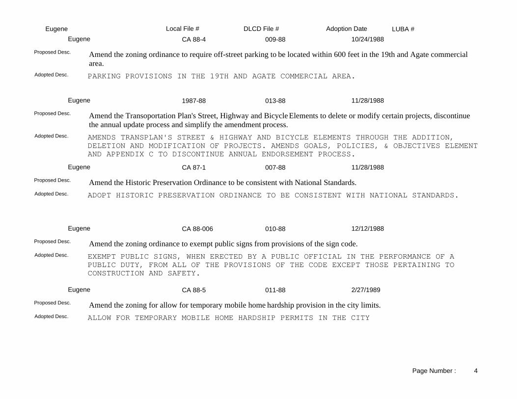
LUBA #Adoption DateLocal File # DLCD File #EugeneCA 88-4 009-88Eugene 10/24/1988
PARKING PROVISIONS IN THE 19TH AND AGATE COMMERCIAL AREA.Adopted Desc.
Amend the zoning ordinance to require off-street parking to be located within 600 feet in the 19th and Agate commercial area.
Proposed Desc.
1987-88 013-88Eugene 11/28/1988
AMENDS TRANSPLAN'S STREET & HIGHWAY AND BICYCLE ELEMENTS THROUGH THE ADDITION, DELETION AND MODIFICATION OF PROJECTS. AMENDS GOALS, POLICIES, & OBJECTIVES ELEMENTAND APPENDIX C TO DISCONTINUE ANNUAL ENDORSEMENT PROCESS.
Adopted Desc.
Amend the Transoportation Plan's Street, Highway and Bicycle Elements to delete or modify certain projects, discontinue the annual update process and simplify the amendment process.
Proposed Desc.
CA 87-1 007-88Eugene 11/28/1988
ADOPT HISTORIC PRESERVATION ORDINANCE TO BE CONSISTENT WITH NATIONAL STANDARDS.Adopted Desc.
Amend the Historic Preservation Ordinance to be consistent with National Standards.Proposed Desc.
CA 88-006 010-88Eugene 12/12/1988
EXEMPT PUBLIC SIGNS, WHEN ERECTED BY A PUBLIC OFFICIAL IN THE PERFORMANCE OF A PUBLIC DUTY, FROM ALL OF THE PROVISIONS OF THE CODE EXCEPT THOSE PERTAINING TO CONSTRUCTION AND SAFETY.
Adopted Desc.
Amend the zoning ordinance to exempt public signs from provisions of the sign code.Proposed Desc.
CA 88-5 011-88Eugene 2/27/1989
ALLOW FOR TEMPORARY MOBILE HOME HARDSHIP PERMITS IN THE CITYAdopted Desc.
Amend the zoning for allow for temporary mobile home hardship provision in the city limits.Proposed Desc.
Page Number : 4

LUBA #Adoption DateLocal File # DLCD File #EugeneNA 001-89Eugene 7/10/1989
UPDATE THE 1983 PARKS AND RECREATION MASTER PLAN.Adopted Desc.
Amend the comprehensive plan to update the 1983 Parks and Recreation Master Plan.Proposed Desc.
NA 008-88Eugene 8/14/1989
Adopted Desc.
Amend the Urban Facilities Plan to specify that the plan diagram and subarea recommendations provide policy guidance. This proposal also includes a change in the plan diagram from Low to Medium Density and a zone change from RA (Suburban Residential) to R-2 (Limited Multiple Family Residential) for approximately 2.6 acres located on the east side of River Road, north of Fir Lane and West of Lombard Lane.
Proposed Desc.
CA 89-1 004-89Eugene 10/9/1989
REGULATION OF PLACEMENT OF AMATEUR RADIO ANTENNA STRUCTURES, ALLOWED IN ALL ZONING DISTRICTS WHICH ALLOW RESIDENTIAL DWELLINGS. INCLUDES DEVELOPMENT STANDARDS PERTAINING TO HEIGHT, SETBACK AND SAFETY.
Adopted Desc.
Amend the zoning ordinance to adopt new definitions and standards to regulate the placement of amateur radio autenna structures.
Proposed Desc.
ORE R-18 003-88Eugene 11/1/1989
AMEND URBAN RENEWAL PLAN FOR CENTRAL EUGENE PROJECT AREA.Adopted Desc.
Amend the Urban Renewal Plan for Central Eugene Project area setting forth: definitions; expaded objectives; listing of public improvements intended to implement policies contained in the Downtown Plan; and intended use of City-owned land.
Proposed Desc.
RA 90-1 001-90Eugene 4/9/1990
ALLOW A LOW-DENSITY RESIDENTIAL ZONING DESIGNATION TO BE APPLIED TO THE SOUTHWEST CORNER OF 5TH AVENUE AND MADISON STREET.
Adopted Desc.
Amend the comprehensive plan from R-3 (Medium to High Density Residential) to RA (Suburban Residential) for 0.25 acrelocated on the southwest corner of 5th Avenue and Madison Street.
Proposed Desc.
Page Number : 5

LUBA #Adoption DateLocal File # DLCD File #EugeneCA 90-3 002-90Eugene 7/23/1990
REDUCE OFF-STREET PARKING SPACES FOR MULTI-FAMILY HOUSING IN THE DOWNTOWN AREA.Adopted Desc.
Amend the zoning to reduce the required off-street parking spaces for multi-family housing in the downtown area from 1-1/2 spaces to 1 space. NOTE: The proposal was submitted without text.
Proposed Desc.
CA 89-3 002-89Eugene 7/25/1990
ADOPTS CHANGES TO SIGN CODE ESTABLISHING PROVISIONS BY ZONING DISTRICT, AND REFORMATTING THESE PROVISIONS WITHIN THE CITY'S ZONING ORDINANCE.
Adopted Desc.
Amend the comprehensive plan and zoning ordinance to revise and update the City of Eugene's Sign Code.Proposed Desc.
2379 005-90Eugene 10/24/1990
Lane County also adopted it on November 21, 1990.Adopted Desc.
Amend the comprehensive plan to include a revised airport master plan.Proposed Desc.
CA 90-5 009-90Eugene 2/11/1991
Adopted Desc.
Amend the zoning ordinance to reduce the required parking in the multi-family units. NOTE: The proposal was submitted without text.
Proposed Desc.
CA 90-6 002-91Eugene 4/8/1991
Adopted Desc.
Amend the zoning ordinance to reduce the required off-street parking for multi-family dwellings from 1-1/2 to 1 space per unit in the portion of the multi-unit property tax exemption area that is south of 13th Avenue.
Proposed Desc.
Page Number : 6

LUBA #Adoption DateLocal File # DLCD File #EugeneCA 90-7 003-91Eugene 4/22/1991
Adopted Desc.
Amend the zoning ordinance to comply with state legislation regarding manufactured housing (HB 2863).Proposed Desc.
CA 90-8 001-91Eugene 8/22/1991
Adopted Desc.
Amend the zoning ordinance to make numerous housekeeping amendmentds regarding day-to-day administration and statutory requirements.
Proposed Desc.
CA 91-5 003-92Eugene 4/13/1992
Adopted Desc.
Amend the zoning ordinance to: (1) clarify specific code provisions; (2) change notice procedures for historic landmark designations; (3) improve staff efficiencies associated with historic landmark alterations; (4) improve the ablity of property owners to see modifications to certain city regulations; and (5) allow properties listed on the National Register to be eligible for the city historic loan program.
Proposed Desc.
RA 92-1 006-92Eugene 4/13/1992
Light-Medium Industrial to Whiteaker Industrial/Commercial District.Adopted Desc.
Amend the comprehensive plan and zoning from I-2 (Light Industrial) to MU (Light Industrial/Mixed Use) for 10.53 acres located north of the Railroad Tracks between Washington and Pearl Streets.
Proposed Desc.
CA 91-3 005-92Eugene 4/13/1992
Adopted Desc.
Amend the zoning ordinance and city code to add new provisions and clarify language.Proposed Desc.
Page Number : 7

LUBA #Adoption DateLocal File # DLCD File #EugeneCA 91-3 005-92Eugene 4/27/1992
Second adoption for the proposal.Adopted Desc.
Amend the zoning ordinance and city code to add new provisions and clarify language.Proposed Desc.
CA 91-4 004-92Eugene 4/27/1992
Adopted Desc.
Amend the zoning ordinance in the RA (Suburban) and R-1 (Low Density Residential) to allow wildlife rehabilitation with specified standards.
Proposed Desc.
NA 001-92Eugene 6/5/1992
Commercial Lands Study.Adopted Desc.
Approve a Commerical Lands Study for the Eugene portion of the Urban Growth Boundary. The study inventories commercial lands and inventories commercial need through the year 2010, and also recommends commerical policy and amendments.
Proposed Desc.
NA 001-92Eugene 10/12/1992
Adoption from Eugene, regarding commercial lands and the forecasted demend through the year 2010.Adopted Desc.
Approve a Commerical Lands Study for the Eugene portion of the Urban Growth Boundary. The study inventories commercial lands and inventories commercial need through the year 2010, and also recommends commerical policy and amendments.
Proposed Desc.
NA 002-92Eugene 10/14/1992
Adopted Desc.
Amend the comprehensive plan to add the Urban Forest Management Plan for application within the city limits.Proposed Desc.
Page Number : 8

LUBA #Adoption DateLocal File # DLCD File #EugeneCATS 002-93Eugene 4/26/1993
Adopted Desc.
Amend the comprehensive plan to update the Central Area Transportation Plan. Address policies, projects, transportation system, parking, and implements the statewide Transportation Planning Rule.
Proposed Desc.
CA 92-1 003-93Eugene 12/6/1993
Adopted Desc.
Amend the zoning ordinance to comply with the state law n regarding the Transportation Rule.Proposed Desc.
MA 93-1 001-94Eugene 2/14/1994
Adopted Desc.
Amend the comprehensive plan from Low Density Residential to Light-Medium Industrial and zoning from RA/UL (Suburban Residential/Urbanizable Land) to I-2/SR/UR (Light-Medium Industrial/Urbanizable Land/Site Review Subdistrict) for 12.6 acres located west of Elizabeth Street between Theona Street and Beltline Highway.
Proposed Desc.
CA 93-4 003-94Eugene 5/9/1994
Adopted Desc.
Amend the zoning ordinance to allow outdoor, portable, non-motorized vending units to be located on non-residential private property upon issuance of a license.
Proposed Desc.
Whiteaker 005-94Eugene 8/1/1994
Appealed by private person.Adopted Desc.
Amend the comprehensive plan and zoning ordinance to do an extensive update of the Whitaker Neighborhood Plan. Also the proposed actions would make changes to the Eugene Springfield Metro Plan. The changes address mixed land uses, the historic district, parks and recreation, plan and map changes, neighborhood issues, and policies to ensure consistency between the City of Eugene and the Metro Plan.
Proposed Desc.
94-158
Page Number : 9

LUBA #Adoption DateLocal File # DLCD File #EugeneCA 93-2 004-94Eugene 8/1/1994
Adopted Desc.
Amend the zoning ordinance to reflect the changes regarding missions in the I-2 (Light-Medium) zone. This proposal reflects a compromise agreement between the Eugene Mission and the Whiteaker Neighborhood.
Proposed Desc.
CA 94-2 006-94Eugene 12/7/1994
Adopted Desc.
Amend the zoning and land division codes to: 1) establish minimum density requirements in low density residential zones; 2) establish minimum density requirements in the multi-family residential zones; and 3) require subdivisions and planned unit developments which exceed 19 lots to disperse motor traffic onto more than one local public street. NOTE: This file has been closed out and the contents have been placed into 003-96. This plan amendment has been appealed LUBA 96-149.
Proposed Desc.
CA 92-2 003-95Eugene 4/24/1995
Adopted Desc.
Amend the zoning ordinance to implement policies in the West Eugene Wetlands Plan. Create a new NR (Natural Resources District), and new WP (Waterside Protection) and WB (Wetland Buffer) subdistricts. Amendments include design standards for certain development adjacent to protected wetlands and waterways.
Proposed Desc.
RA 95-001 002-95Eugene 5/30/1995
Adopted Desc.
Amend the comprehensive plan to the West Eugene Wetlands Plan from Wetlands to be Protected (and I-2) to Wetlands to be Development (and I-2) on two locations consisting of 1) east of Terry Street and north of Arrowsmith (.78 acre); and 2) between Bailey Hill and Market (.64 acre).
Proposed Desc.
CA 95-1 004-95Eugene 1/24/1996
Adopted Desc.
Amend the land use regulations regarding: (1) The Controlled Income and Rent provisions for density increase; and, (2) The criteria to refer the locational standards to the map only, eliminating reference to block group.
Proposed Desc.
Page Number : 10

LUBA #Adoption DateLocal File # DLCD File #EugeneCA 95-2 002-96Eugene 8/5/1996
Adopted Desc.
Amend the land use regulations and map to implement local street plan recommended block length and connectivity standards.
Proposed Desc.
CA 96-01 003-96Eugene 2/26/1997
Adopted Desc.
Amend the land use ordinance to regulate telecommunication facilities. REVISION REC'D 1/15/97.Proposed Desc.
MA 97-1 001-97Eugene 8/4/1997
Adopted Desc.
Amend the comprehensive plan map (and zoning map) from Commercial (and PL) to Government and Education (and PL) on approximately 5 acres located at 2411 Centennial Boulevard.
Proposed Desc.
MA 97-2 003-97Eugene 11/24/1997
Adopted Desc.
Amend the comprehensive plan map from Light-Medium Industrial - 2 parcels and Campus Industrial - 1 parcel (and Light-Medium Industrial and Special-Light Industrial) to Community Commercial (and C-2) on 13.64 acres with 2 parcels located on the north side of Pitchford Avenue, west of Westec Drive and the third parcel located on the southwest corner of Pitchford Avenue and Willow Creek Road. ORIGINAL HEARING DATE: 9/8/97. REVISED HEARING DATE: 10/13/97.
Proposed Desc.
Growth Manag 002-97Eugene 2/2/1998
Adopted Desc.
Amend the refinement plan, land use regulation, and new land use regulation to better manage growth in Eugene in conformance with broad policy direction of the Eugene-Springfield Metropolitan Area General Plan. The study is specifically Eugene. The Eugene Growth Management Study includes: Land use and housing, transportation, environmental quality, parks and open space, public facilities, and public safety. This proposal was received with only 40 days notice.
Proposed Desc.
Page Number : 11

LUBA #Adoption DateLocal File # DLCD File #EugeneMA 97-4 004-97Eugene 2/23/1998
Adopted Desc.
Amend the comprehensive plan map (and zoning map) from Special Light Industrial (and L-1 Special Light Industrial) to Commercial (and C-2/ SR General Commercial/Site Review) for 2.24 acres located at Chad and Coburg Road.
Proposed Desc.
RA 96-001 001-96Eugene 6/24/1998
Partial Adoption of 85 amendments.Adopted Desc.
Amend the comprehensive plan regarding the West Eugene Wetlands Plan, affecting approximately 568 acres, including: (1) Changes that will incorporate and designate wetland sites identified after adoption of original plan; (2) Changes that will update policies regarding mitigation; (3) Changes respond to new information gathered subsequent to the adoption of the plan; (4) Changes that create a new designation for planned public roadway improvements within wetland areas; and, (5) Changes to the criteria for protection and development of wetlands. This proposal contains a total of 85 amendments. This original proposal was received on 4/22/96. An updated and refined proposal was received on 2/4/98. Acreage involved changed from 568 acres to 455 acres. This revised proposal was received with only 14 days notice.
Proposed Desc.
MA 98-3 001-98Eugene 12/9/1998
Adopted Desc.
Amend the comprehensive plan map (and zoning map) from Airport Reserve (and EFU/CAS) to Government and Education(and Airport Operations) for 9.1 acres located south of Eugene Airport on Kokkeler Road.
Proposed Desc.
RA 96-001 001-96Eugene 4/21/1999
Please Note: The second of 85 amendments.Adopted Desc.
Amend the comprehensive plan regarding the West Eugene Wetlands Plan, affecting approximately 568 acres, including: (1) Changes that will incorporate and designate wetland sites identified after adoption of original plan; (2) Changes that will update policies regarding mitigation; (3) Changes respond to new information gathered subsequent to the adoption of the plan; (4) Changes that create a new designation for planned public roadway improvements within wetland areas; and, (5) Changes to the criteria for protection and development of wetlands. This proposal contains a total of 85 amendments. This original proposal was received on 4/22/96. An updated and refined proposal was received on 2/4/98. Acreage involved changed from 568 acres to 455 acres. This revised proposal was received with only 14 days notice.
Proposed Desc.
Page Number : 12

LUBA #Adoption DateLocal File # DLCD File #EugeneCA 99-1 003-99Eugene 6/14/1999
Adopted Desc.
Amend the (definition of "Metro Plan Home Jurisdiction") Metro Plan to transfer jurisdiction of Glenwood to Springfield. This proposal was received with 31 days notice.
Proposed Desc.
MA 98-01,RA 98-01, Z 002-99Eugene 7/26/1999
The adopted version denied the proposed amendments to the Metro Plan and Willakenzie Area Plan and rezoning request.Adopted Desc.
Amend the comprehensive plan map (and zoning map) from MDR, Medium Density Residential to C, Commercial (and from R-1, Low Density Residential to C-2/SR, General Commercial with Site Review) for 0.7 acres, located East of Coburg Road, North of Rustic Place. This proposal was received with 38 days notice.
Proposed Desc.
RA 99-07/ Z 99-18 005-99Eugene 11/22/1999
Same.Adopted Desc.
Amend the Jefferson/Far West Refinement plan (and the zoning map) from PL, Public Land to C, Commercial (and from PL, Public Land to C-2, General Commercial) for 1.5 acres, located at 100 W. 13th Avenue. This proposal was received with only 43 days notice, before the first evidentiary hearing.
Proposed Desc.
CA 97-1 001-99Eugene 11/22/1999
Adopted Version: Design guidelines were adopted along with standards and minor changes to street classification map; explanatory textwas added to exceptions section; minor changes were made to individual standard and guidelines.
Adopted Desc.
(1) Amend the Design Standards Ordinance concerning Arterial and Collector Streets. (2) Amend Section 9.045 (Platting Standards of Streets and Roads) of the City Code of 1971 to change Major and Minor Arterials and Major Collector Streets. (3) Adopt a resolution to Implement new Design Standards for Streets, Sidewalks, Bikeways and Access Ways and repeal Resolution No. 4500. (4) Adopt a Resolution to implement new Design Standards and Guidelines for Transit Facilities, and repeal Resolution Nos. 4391 and 4501 (5) Adopt a new Arterial and Collector Street Plan to provide direction, guidelines and standards for the construction and reconstruction of Major Streets (non-local) and Collector Streets. This proposal was received with 42 days notice.
Proposed Desc.
Page Number : 13

LUBA #Adoption DateLocal File # DLCD File #EugeneRA 96-001 001-96Eugene 11/23/1999
Adopted Version: Amendments are part of a larger set of amendments, some of which have not been adopted yet. Changes to the wetland designation criteria were made by elected officials in response to public testimony. Primarly to clarify intent.
Adopted Desc.
Amend the comprehensive plan regarding the West Eugene Wetlands Plan, affecting approximately 568 acres, including: (1) Changes that will incorporate and designate wetland sites identified after adoption of original plan; (2) Changes that will update policies regarding mitigation; (3) Changes respond to new information gathered subsequent to the adoption of the plan; (4) Changes that create a new designation for planned public roadway improvements within wetland areas; and, (5) Changes to the criteria for protection and development of wetlands. This proposal contains a total of 85 amendments. This original proposal was received on 4/22/96. An updated and refined proposal was received on 2/4/98. Acreage involved changed from 568 acres to 455 acres. This revised proposal was received with only 14 days notice.
Proposed Desc.
CA 99-9 006-99Eugene 1/24/2000
The Firm maps were amended to be updated per administrative order per the City Attorney.Adopted Desc.
Amend the city code to update the Flood Insurance Rate Map and declare an emergency for expedited review under ORS 197.610(2).Proposed Desc.
Ordinance No. 20194 001-00Eugene 4/24/2000
Final regulations applies to all open waterways; where as, the proposed ordinance would have applied only to waterways designated as "Key".
Adopted Desc.
Amend the city code to add sections 6.650, 6.655, 6.660, 6.665, 6.670, 6.675, and 6.680 all dealing with prohibit filling and/or piping of key storm waterways.
Proposed Desc.
2000-104
RA 96-001 001-96Eugene 8/30/2000
Several new wetland sites were added to the amendments. Some proposed site designations were changed in response to new information submitted through the public hearing process. Proposed amendments related to the planned West Eugene Parkway were removed from these amendments and will be considered at a later date.
Adopted Desc.
Amend the comprehensive plan regarding the West Eugene Wetlands Plan, affecting approximately 568 acres, including: (1) Changes that will incorporate and designate wetland sites identified after adoption of original plan; (2) Changes that will update policies regarding mitigation; (3) Changes respond to new information gathered subsequent to the adoption of the plan; (4) Changes that create a new designation for planned public roadway improvements within wetland areas; and, (5) Changes to the criteria for protection and development of wetlands. This proposal contains a total of 85 amendments. This original proposal was received on 4/22/96. An updated and refined proposal was received on 2/4/98. Acreage involved changed from 568 acres to 455 acres. This revised proposal was received with only 14 days notice.
Proposed Desc.
Page Number : 14

LUBA #Adoption DateLocal File # DLCD File #EugeneRA 96-001 001-96BEugene 9/13/2000
These amendments were modified in response to public testimony before both the planning commissions and elected officals. Modification were made to the areas designated for restoration and development.
Adopted Desc.
Amend the comprehensive plan regarding the West Eugene Wetlands Plan, affecting approximately 568 acres, including: (1) Changes that will incorporate and designate wetland sites identified after adoption of original plan; (2) Changes that will update policies regarding mitigation; (3) Changes respond to new information gathered subsequent to the adoption of the plan; (4) Changes that create a new designation for planned public roadway improvements within wetland areas; and, (5) Changes to the criteria for protection and development of wetlands. This proposal contains a total of 85 amendments. This original proposal was received on 4/22/96. An updated and refined proposal was received on 2/4/98. Acreage involved changed from 568 acres to 455 acres. This revised proposal was received with only 14 days notice.
Proposed Desc.
RA 96-001 001-96Eugene 11/1/2000
These amendments were modified in response to testimony received regarding rare plants and access issues for future development oon developable areas. These changes affected wetlands immediately west of the access road to the Speedway facility. Note: This is the Final ordinance for Eugene File RA 96-1.
Adopted Desc.
Amend the comprehensive plan regarding the West Eugene Wetlands Plan, affecting approximately 568 acres, including: (1) Changes that will incorporate and designate wetland sites identified after adoption of original plan; (2) Changes that will update policies regarding mitigation; (3) Changes respond to new information gathered subsequent to the adoption of the plan; (4) Changes that create a new designation for planned public roadway improvements within wetland areas; and, (5) Changes to the criteria for protection and development of wetlands. This proposal contains a total of 85 amendments. This original proposal was received on 4/22/96. An updated and refined proposal was received on 2/4/98. Acreage involved changed from 568 acres to 455 acres. This revised proposal was received with only 14 days notice.
Proposed Desc.
005-00Eugene 11/27/2000
Section 2.060(2)(6) was amended to provide notice within 300 feet of the perimeter of the subject property rather than 100 feet as provided in the draft ordinance.
Adopted Desc.
Amend the Eugene Code, 1971 to renumber Sections 2.030 to 2.150 and 2.070 to 2.170; and new Sections 2.040, 2.045, 2.050, 2.055, 2.060, and 2.065 dealing with Real Property Compensation to comply with Ballot Measure 7 (BM7). These provisions include the possiblity of discontinuing to apply regulations. This proposal was received with 5 days notice before the first evidentiary hearing.
Proposed Desc.
2000-259
CA-002 002-00Eugene 1/22/2001
Same.Adopted Desc.
Amend the Eugene Code Chapter 9, Land Use in several sections to allow expansion of the University of Oregon's Autzen Stadium without adding additional on-site parking spaces. Amend the Transportation System Plan to add a Transportation Demand Management Plan to provide for transit, pedestrian and bicycle enhancements in lieu of additional parking for the stadium. This proposal was submitted without text or maps.
Proposed Desc.
Page Number : 15

LUBA #Adoption DateLocal File # DLCD File #EugeneCA 95-3 007-99Eugene 3/2/2001
Adopted version: Amendments to the ordinance adopted by the Council on 02/26/2001; Amendments to the Ordinance from Council work sessions through 12/00; February 2001 Land Use Code -- Legislative version showing changes from the November 1999 draft provided with 01/18/2000 Proposed Action.
Adopted Desc.
Amend the land use code to update the entire set of land use regulations for all areas in the Urban Growth Boundary.Proposed Desc.
PA 99-5599 004-99Eugene 3/19/2001
Site review suffix added to the zone change.Adopted Desc.
Amend the comprehensive plan map (and the zoning map) from AG, Agriculture to RS, Residential (and from EFU-40, Exclusive farm Use-40 to RR-5, Non-Resource Rural Residential) for 12.5 acres, located at the southwest corner of Royal Avenue and Greenhill Road. This proposal is a combined notice with the City of Springfield # 007-99 and Lane County #012-99, and includes an exception.
Proposed Desc.
CA 95-3 007-99Eugene 5/29/2001
This ordinance didnot change the recently adopted land use code. It simply changed the effective date of the ordinance.Adopted Desc.
Amend the land use code to update the entire set of land use regulations for all areas in the Urban Growth Boundary.Proposed Desc.
Eugene: CA 01-2 002-01Eugene 10/8/2001
Refer to changes shown in legislative format attached. Since initial notice, additional errors or clarifications were identified, such as additional figures that needed to be amended to be consistent with the text. Further amendments were done to clarify when the adopted standards apply to new versus existing development. Greater flexibility was provided to allow adjustments to standards and further work was done related to geotechnical standards. This is co adopted with Lane County 011-01
Adopted Desc.
Amend the land use code to correct errors in the following areas: definitions, zoning, setbacks, tables, development standards, lot standards, solar setback standards, sign standards, geotechnical and geological analysis, parking lot lighting, special event parking, pedestrian surfaces, lot setbacks, exemptions, conditional use, subdivisions, general requirements, and adopted plans. This proposal affects land inside the city limits and outside the city limits. The proposal is a joint proposal with Lane County 011-01, and will be adopted together.
Proposed Desc.
RA 01-02 003-01Eugene 12/10/2001
Same.Adopted Desc.
Amend the Whiteaker Refinement Plan (and the zoning map) from Public to Mixed Use (and from PL, Public Land to S-W, Whiteaker Mixed Use) for 0.19 acre, located at the northeast corner of 1st Avenue and Clark Street. This proposal was received without text. This proposal was received with 43 days notice before the first evidentiary hearing.
Proposed Desc.
Page Number : 16

LUBA #Adoption DateLocal File # DLCD File #EugeneEugene: CA 01-2 002-01AEugene 12/10/2001
Clarification to commercial standards is the same as proposed. Changes were made to flag lot provisions. Refer to updated, consolidated list of chnages in legislative format.
Adopted Desc.
Amend the land use code to correct errors in the following areas: definitions, zoning, setbacks, tables, development standards, lot standards, solar setback standards, sign standards, geotechnical and geological analysis, parking lot lighting, special event parking, pedestrian surfaces, lot setbacks, exemptions, conditional use, subdivisions, general requirements, and adopted plans. This proposal affects land inside the city limits and outside the city limits. The proposal is a joint proposal with Lane County 011-01, and will be adopted together.
Proposed Desc.
CA 95-3 007-99REugene 3/8/2002
Correction of scrivenor's errors and minor revisions to address LUBA remand.Adopted Desc.
Amend the land use code to update the entire set of land use regulations for all areas in the Urban Growth Boundary.Proposed Desc.
CA 02-01 003-02Eugene 10/30/2002
Section 9.4250 was amended to add "at least" prior to "12 units per net residential acre." Section 9.4280(b) was amended to clarify that more than one retail tenant could occupy the new building, that the 50, 000 square foot limitation was for building area on the ground floor and that only one such building may contain 50,000 square feet of building area on the ground floor.
Adopted Desc.
Amend the Eugene Code, Chapter 9, Land Use Regulations Within the Eugene Urban Growth Boundary, to correct errors and make clarifications; revise flag-lot standards; adjust secondary dwelling standards and parking standards; clarify application procedures and criteria; and adopt various tables. Per City, 61 sections are included. This proposal considered a joint submission by Lane County.
Proposed Desc.
MA 01-5, * 004-01Eugene 11/12/2002
Overall concept is very similar. Specific design standards were added ( i. e., required second floor in commercial area, entrance orientation) and additional opportunties for mixed use develoment in Historic Ensemble.
Adopted Desc.
Amend the Eugene Code 9.1030 "Establishment and List of Zones", 9.3000, "Purpose for Creating Spercial Area Zones", and 9.3020 "Criteria for Establishment of an S Special Area Zone"; and add the following new sections: 9.3100 "Purpose of S-CGN Chase Gardens Node Special Area Zone", 9.3105 "S-CGN Chase Gardens Node Special Area Zone Siting Requirements", 93.110 "S-CGN/PL Chase Garden Node Public land Subarea..........", 9.3115 "S-CGN Chase Garden Node Special Area Zone Land use and Permit", 9.116 "Special Use Limitation for Table 9.3115", 9.3120 "Prohibited Uses in the S-CGN Chase Gardens Node Special Area Zone", 9.3125 "S-CGN Chase Gardens Node Special Area Zone development Standards". The Chase Gardens Nodal Development Area is approximately 170.00 acres in size, located north of Centennial Boulevard, west of Interstate 5, south of Interstate 105, and east of Chevy Case Lane. Eugene Local File Number * MA 01-5, RA 01-5, Ca 01-3, Z 01-25. This proposal is related to Eugene-Springfield Metro 001-01 (11830).
Proposed Desc.
Page Number : 17

LUBA #Adoption DateLocal File # DLCD File #EugeneCA 02-3 & Z 02-15 002-02Eugene 11/25/2002
Fewer regulations / restrictions adopted.Adopted Desc.
Amend the plan text of the Eugene Municipal Code Chapter 9, Land Use, Section 9.4000, and to amend the Eugene Overlay Zoning Map, to create a new "Broadway Design Standards Overlay Zone" to be located at the three blocks between Oak and Charnelton Streets in downtown Eugene. Standards include building setback, entrance locations, floor height, transparent window / door requirements, display window lighting minimum timing, rain protection along Broadway, and signage regulations. Prohibited uses include visible parking garages, outdoor storage, non-customer interaction uses, and others. Further details in actual text.
Proposed Desc.
CA 02-01 003-02AEugene 11/25/2002
Amendments expanded to include change in term "Assisted Living" to "Assisted Care" to address State licensing concern. Amendmens added to include clarification and correction of applicable standards for Downtown Westside zone (9.3215), /TD overlay (9.4530). Improvements (9.6505), add amendment to clarify recordation of vacations (9.7030), correct conflict in code provisions related to 9.5250 farm Animal Standards, add change to clarify legal lot requirement prior to land divisions (9.8210 and 9.8510), correct error in reference to South Hills Study at 9.9630, increase number of display signs for certain land use decisions, reduce interior yard setbacks for flag and alley lots.
Adopted Desc.
Amend the Eugene Code, Chapter 9, Land Use Regulations Within the Eugene Urban Growth Boundary, to correct errors and make clarifications; revise flag-lot standards; adjust secondary dwelling standards and parking standards; clarify application procedures and criteria; and adopt various tables. Per City, 61 sections are included. This proposal considered a joint submission by Lane County.
Proposed Desc.
Royal Ave Spfic Plan 003-00Eugene 1/13/2003
Several policies have been added to the Bethel-Danebo Refinement Plan Amendments describing the various revisions that were made to the plan during the adoption process. Those revisions are embodied in the Errata to Exhibit C of Ordinance No. 20274.
Adopted Desc.
Amend the Eugene code to add Sections 9.3800 to 9.3823 and revise the following sections: 9.300, 9.3020, 9.6000, 9.8030, 9.8090, 9.8100, 9.8215, 9.8220, 9.8515, 9.8520, and 9.8865 to add the Royal Avenue Specific Plan for the future development of the Royal Avenue Development site, an area of 191.00 acres of property located along Royal Avenue between Terry Street and Greenhill Road and within the Bethel Neighborhood. The specific plan details the following elements for future development within the Royal node: (1) Commercial Center, (2) Residential Development areas, (3) Commercial Mixed-Use, (4) Residential Mixed-Use, (5) Two neighborhood-scale parks, (6) Transit Center, (7) Multi-Use corridors, (8) Street Network, (9) Infrastruture improvements, and (10) Infrastructure financing program. The original proposal was received on June 6, 2000, and with 39 days notice before the first evidentiary hearing. This revised notice is essentially the same, received with 48 days notice, and has new first and final hearing dates.
Proposed Desc.
CA 02-01 003-02BEugene 2/24/2003
Deletion of a proposed change to require that if there were 225 or more off-street parking spaces on a development site, that at least 25% of the spaces shall be in structure parking. After careful consideration, the requirement for structured parking was removed from the list of changes. Regarding 9.6410, the parking ration for elementary and middle schools was adjusted. No change to 9.6430.
Adopted Desc.
Amend the Eugene Code, Chapter 9, Land Use Regulations Within the Eugene Urban Growth Boundary, to correct errors and make clarifications; revise flag-lot standards; adjust secondary dwelling standards and parking standards; clarify application procedures and criteria; and adopt various tables. Per City, 61 sections are included. This proposal considered a joint submission by Lane County.
Proposed Desc.
Page Number : 18

LUBA #Adoption DateLocal File # DLCD File #EugeneCA 02-01 003-02CEugene 3/10/2003
Adopted code changes did not include a proposed requirement to mandate the use of parking garages for large parking areas. Change the requirements for parking are landscaping to allow for phased developments and partial upgrades to encourage redevelopment. Clarified allowance of high-density residential development in the S-DW, Downtown Westside Special Area Zone. Made minor refinements to various proposed amendments to increase clarity of the code.
Adopted Desc.
Amend the Eugene Code, Chapter 9, Land Use Regulations Within the Eugene Urban Growth Boundary, to correct errors and make clarifications; revise flag-lot standards; adjust secondary dwelling standards and parking standards; clarify application procedures and criteria; and adopt various tables. Per City, 61 sections are included. This proposal considered a joint submission by Lane County.
Proposed Desc.
Admin Rule #58-02-25 005-02Eugene 3/31/2003
Deleted definition of "Complex Project," slightly revised definitions of "Engineering Properties of Soil and Rock," "Expansive Soil," "Indexof Properties of Soil or Rock," "Representative Sample," and "Soil Disturbance." Revised Section R-9.6710-F.1.1 and 1.2, deleted 1.3. Added Section R-9.6710-F.2.2.7. Complete revision of Section R-9.6710-F.4. Revised Section R-9.6710-F-G.2.3. Revised Section R-9.6710-G.3.4. Deleted R-9.6710-G.3.7. Complete revision of Section R-9.6710-G.4. Deleted Sections R-9.6710-H.1.4 and 1.5. Revised Section R-9.6710-H.2.3. Deleted Section R-9.6710-G.3.8. Added New Section R-9.6710-I, Seal and Signature Requirement. Revised Section R-9.6710-I (renumbered as R-9.6710-J), Alternative Methods of Investigation. Deleted previous Section R-9.6710-J.
Adopted Desc.
Amend the city code Chapter 9 to adopt Administrative Rule No. 58-02-05 as an element. The administrative rule establishes standards, procedures and content for geological and geotechnical analysis that must be submitted (per the city code Section 9.6710) with land use application proposing tentative PUD, site review, or subdivision on property with slopes greater than five percent; or proposing development that includes dedication or construction of public streets, streets construction of public drainage system, or public wastewater systems. This proposal was received with 43 days notice before the first evidentiary and final hearings.
Proposed Desc.
CA 95-3 007-99REugene 8/11/2003
The adopted ordinance differed by removing a requirement that housing projects automatically include traffic calming features based strictly on projected increases in traffic; removing requirement that transit facilities automatically be provided; removing references to emergency medical travel time. The adopted ordinance reinstates most, although not all, of the needed housing provisions remanded through clear and objective standards.
Adopted Desc.
Amend the land use code to update the entire set of land use regulations for all areas in the Urban Growth Boundary.Proposed Desc.
CA 03-1 010-03Eugene 10/22/2003
Only minor changes were made to the original proposal. The definition of "hospital" was revised, adnd minor adjustments to the use lists and development standards were made, resulting on further restrictions on hospital siting opportunties.
Adopted Desc.
Amend the land use code to allow hospitals and related facilities as a permitted or conditional use in various zoning districts.Proposed Desc.
Page Number : 19

LUBA #Adoption DateLocal File # DLCD File #EugeneMA03-1;RA03-2;Z03-3 011-03Eugene 11/10/2003
The adopted ordinance was changed to clarify that the Cresent Village area is suitable for mix of uses within a maximum land use intensity. The ordinance also was changed to require that all of the area within Cresent Village be reviewed through a PUD. The Ordinance was changed to include concurrent rezoning of all land impacted by the changes to the plan diagram and to apply the /PD Planned Unit Development overlay zone to the entire Cresent Village boundary.
Adopted Desc.
Amend the comprehensive plan map (and the zoning map) from High Density Residential to Commercial and Mixed Use for 10.60 acres (and from R-4, High Density Residential to GO, General Office for 39.33 acres) for a total of 49.93 acres, located on the north side of Cresent Avenue and east of Coburg Road. Amend the Cresent Area node and the Willakenzie Area Plan to provide policy framework for an overall master plan for the site.
Proposed Desc.
RA 03-1 & CA 03-4 013-03Eugene 12/3/2003
The amendment differs by simply removing the special prohibition on clinics and not placing a square footage size limitation on the amount of clinic space on the particular site.
Adopted Desc.
Amend the Willakenzie Area Plan-Coburg/Cresent Subarea Policy 2 and the Eugene Code on two subsections to allow medical clinics and offices of 50,000 square feet or less in the neighborhood commercial areas.
Proposed Desc.
MA 03-2 006-03Eugene 4/12/2004
CA 03-3 was not included in notice delivered 05/16/2003. Adopted items same as listed in notice mailed 12/09/2004. Also see DLCD File No. 007-03 and 008-03.
Adopted Desc.
Amend the Metro Plan Diagram from Heavy Industrial to Commercial for two parcels on approximately 8.50 acres, located north of 8th Avenue, and east of High Street, and next to the Southern Pacific Railroad tracks. The parcel will be developed as the new Federal Courthouse and parking. This proposal was received without text.
Proposed Desc.
MA 03-3 007-03Eugene 4/12/2004
Same. Also see DLCD File No. 006-03 and 008-03.Adopted Desc.
Amend the Metro Plan Diagram from Commercial to Commercial with a Nodal Development to properties located within the Downtown Plan Study Area, which is north of 14th Avenue, east of Lincoln Street, south of 4th Avenue, and west of Hilyard. This proposal was received without text.
Proposed Desc.
RA 03-3 008-03Eugene 4/12/2004
CA 03-3 was not included in notice delivered 5/16/2003. Adopted items same as listed in notice mailed 12/09/2003. Also see DLCD File No. 006-03 and 008-03.
Adopted Desc.
Adopt a new Downtown Plan to replace the existing 1984 Eugene Downtown Plan as a refinement to the Eugene Springfield Metro Area General Plan. Revised Notice: The revised notice changes the final hearing date from September 8, 2003 to January 26, 2004.
Proposed Desc.
Page Number : 20

LUBA #Adoption DateLocal File # DLCD File #EugeneRA 03-4 009-03Eugene 5/24/2004
Amendment to the 2004 Draft Central Area transportation Study are shown in Attachment A - Recommended Changes to the draft June 2003 Central Area Transportation Study by the Eugene Planning Commission and modified by the Eugene City Council.
Adopted Desc.
Amend the Central Area Transportation Study of 1987 to update revised policies and implementation strategies for transportation projects within the CATS area. The policies and projects that are identified in the plan will serve as the Transportation Element of the draft 2003 Downtown Plan Update. This proposal was received with 11 days notice before the first evidentiary hearing.
Proposed Desc.
Page Number : 21

LUBA #Adoption DateLocal File # DLCD File #Florence001-87AFlorence 2/24/1987
FLOODPLAIN ORDINANCEAdopted Desc.
Amend the zoning ordinance's floodplain regulations to conform with revised Federal Emergency Management Agency regulations.
Proposed Desc.
002-87AFlorence 4/28/1987
APPROVAL OF PARK SYSTEM MASTER PLANAdopted Desc.
Amend the comprehensive plan to incorporate by reference the park system master plan.Proposed Desc.
N/A 003-87BFlorence 9/8/1987
Adopted Desc.
Amend the comprehensive plan and zoning from Residential Multiple (RM) District to Highway (H) District for approx. 3 acres located on Pine and 32nd Streets.
Proposed Desc.
N/A 001-88Florence 8/9/1988
PERIODIC REVIEW PLAN UPDATEAdopted Desc.
Amend the comprehensive plan and zoning ordinance to make changes related to the periodic review plan update.Proposed Desc.
NA 002-88Florence 11/22/1988
Adopted Desc.
Amend the comprehensive plan from Residential to Waterfront and zoning from RR (Restricted Residential) to WF (Waterfront) for 0.9 acre located in block 5, south 1/2 of wacated 1st Street, north of Bay Street, east of Juniper, and west of Kingwood.
Proposed Desc.
Page Number : 1

LUBA #Adoption DateLocal File # DLCD File #FlorenceNA 003-90Florence 11/5/1990
Adopted Desc.
Amend the zoning ordinance from Open Space to Multi-Family Residential for two city blocks located north of 9th Street between Driftwood and Greenwood Streets.
Proposed Desc.
NA 001-90Florence 12/3/1990
Adopted Desc.
Amend the zoning ordinance to comply with state legislation regarding the noticing, appeal and hearing requirements.Proposed Desc.
NA 004-90Florence 12/17/1990
Adopted Desc.
Amend the comprehensive plan from Residential to Highway Commercial and Industrial zones; and from Single Family Residential, Commercial and Indusstrial zones to Highway District and Light Industrial zones for 12.5 acres located on Highway 101 near the north city limits.
Proposed Desc.
NA 006-90Florence 2/19/1991
Adopted Desc.
Amend the comprehensive plan from Residential to Highway Commercial and zoning from RS (Single Family Residential) to H (Highway District) for 16 acres located on Highway 101 and Munsel Lake Road. NOTE: This is a reproposal.
Proposed Desc.
NA 005-90Florence 2/19/1991
Adopted Desc.
Amend the comprehensive plan and zoning from C (Commercial) to LIP (Light Industrial Park) for 0.23 acre located on the west side of Highway 226 immediately north of SW 6th Avenue.
Proposed Desc.
Page Number : 2

LUBA #Adoption DateLocal File # DLCD File #FlorenceNA 001-91Florence 6/17/1991
Adopted Desc.
Amend the comprehensive plan to comply with state legislation regarding Coastal Goals 16 and 17, and amend the Coastal Lake and Wetland Maps to show changes in the resource areas. The proposal affects approximately 350 acres.
Proposed Desc.
NA 001-93Florence 8/2/1993
Co-adopted with Lane County (See Lane County - DLCD # 001-93 AAUTO# : 6563)Adopted Desc.
Amend the comprehensive plan from Industrial to Residential and zoning from Limited Industrial to RMH (Residential Mobile/Manufacture Home). Total acrege involved is 78.0 located near Munsel Lake Road and Highway 101.
Proposed Desc.
NA 001-93Florence 9/20/1993
Adopted Desc.
Amend the comprehensive plan from Industrial to Residential and zoning from Limited Industrial to RMH (Residential Mobile/Manufacture Home). Total acrege involved is 78.0 located near Munsel Lake Road and Highway 101.
Proposed Desc.
NA 003-94Florence 9/6/1994
Adopted Desc.
Amend the comprehensive plan (and zoning) from Residential/ Industrial (and RS/LI) to Highway Commercial (and H) for approximatley 9.5 acres located at 5050 Highway 101, near Munsel Lake Road.
Proposed Desc.
Florentine E 001-97Florence 1/19/1998
Adopted Desc.
Amend the comprehensive plan map (and zoning map) from Residential (and Single Family Residential) to Commercial (and Highway District, or proposed Regional Commercial District) to develop a major retail development - factory outlet mall on 16.89 acres located on the southeast quadrant of U.S. Highway 101 and Munsel Lake Road.
Proposed Desc.
98-029
Page Number : 3

LUBA #Adoption DateLocal File # DLCD File #Florencetitle 10, chapt 19 001-98Florence 1/5/1999
Adopted Desc.
Amend the estuary and shorelands section of the city code to revise the Conservation Estuary District (CE) to allow as a conditional use the placement of riprap for protection of existing uses constructed after October 1977. This proposal was received with 42 days notice.
Proposed Desc.
Page Number : 4

LUBA #Adoption DateLocal File # DLCD File #Junction City88-1 001-88Junction City 3/22/1988
Adopted Desc.
Amend the comprehensive plan from Industrial to Commercial and zoning from Light Industrial and Commercial to Commercial for approximately 9 acres bounded by W. 5th Avenue on the north, W. Front Street on the east, W. 2nd Avenueon the south, and alleys between Holly and Ivy Streets.
Proposed Desc.
88-2 002-88Junction City 3/29/1988
Adopted Desc.
Amend the zoning from M-1, Light Industrial District to C-2 P Commercial District for approximately 0.5 acre located at 275 and 295 Greenwood Street.
Proposed Desc.
RZ-88-3 006-88Junction City 7/19/1988
Adopted Desc.
Amend the zoning from R-1 (Single Family Residential) to C-2P (Commercial) for 1.25 acres located at the northeast cornerof W. 18th Avenue and Highway 99E.
Proposed Desc.
RZ-88-2 004-88Junction City 10/11/1988
Adopted Desc.
Amend the zoning from Light Industrial (M1) to Commerical (C2-P) or Downtown Commerical (C2) for 9 acres located south of 5th Avenue, north of 2nd Avenue, west of Front Street and east of Ivy Street.
Proposed Desc.
RZ-89-1 001-89Junction City 6/27/1989
TO PERMIT CERTAIN STORAGE AND WAREHOUSE USES IN THE C-2P (COMMERCIAL) DISTRICT.Adopted Desc.
Amend the zoning ordinance to permit cetain storage and warehouse uses in the C-2 (Commercial) zone.Proposed Desc.
Page Number : 1

LUBA #Adoption DateLocal File # DLCD File #Junction CityNA 001-90Junction City 9/25/1990
2.99 acres added to the adoption.Adopted Desc.
Amend the comprehensive plan from Commercial to Industrial for 3.99 acres located at the southwest corner of 17th and Laurel.
Proposed Desc.
NA 001-91Junction City 4/10/1991
Adoption pertaining to periodic review.Adopted Desc.
Amend the zoning ordinance to establish zoning regulations; provide penalites for violations; conserve and stabilize the value of property; aid in the rendering of fire and police protection; lessen congestion; to faciltate adequate provisions for community utilities and facilities such as water, sewerage, electrical distribution, transportation, parks, and schools.
Proposed Desc.
NA 001-93Junction City 3/23/1993
Adopted Desc.
Amend the comprehensive plan from Low Density Residential to Medium Density Residential and zoning from R2 (Single Family and Duplex Residential) to R4 (Multiple Structure Residential) for 6.6 acres located north of 9th and east of Deal Streets, in the Scandinavian Estates Subdivision.
Proposed Desc.
NA 002-93Junction City 8/10/1993
Comply with legis. amendments, periodic requirements, and map several map changes.Adopted Desc.
Amend the comprehensive plan and zoning to comply with periodic review requirements by: defining wetlands; clarifying zoning administration; making allowances for manufactured housing; addressing coordination with ODOT; and make other miscellanous text changes. Amend the comprehensive plan and zoning and make several map changes for a total of approximately 42 acres located within the city.
Proposed Desc.
NA 004-93Junction City 10/19/1993
Adopted Desc.
Amend the comprehensive plan from Low Density Residential to Medium Density Residential and zoning from R-2 (Duplex Residential) to R-4 (Multi-Structures) for approximately 3.5 acres located at the 600 Block of E 1st, and south of Boden Road.
Proposed Desc.
Page Number : 2

LUBA #Adoption DateLocal File # DLCD File #Junction CityAMD 94-09 006-94Junction City 6/14/1994
Adopted Desc.
Amend the zoning ordinance to clarify the General Commercial zone regarding residential use is allowed.Proposed Desc.
AMD 94-10 007-94Junction City 6/14/1994
Adopted Desc.
Amend the zoning ordinance to add small animal clinics as a permitted use in the General Commercial zone.Proposed Desc.
CPA 95-07 001-95Junction City 6/27/1995
Adopted Desc.
Amend the comprehensive plan (and zoning) from Commercial (and GC) to Medium Density Residential (and R-3) on approximately 2 acres located between Highway 99 and Prairie Road. This proposal was received without text.
Proposed Desc.
CPA 95-10 002-95Junction City 6/27/1995
Adopted Desc.
Amend the comprehensive plan and zoning maps from Industrial (and Light Industrial, M-1) to Medium Density Residential (and Multi-Family Residential, R-3) on 1.13 acres located close to 17th Street.
Proposed Desc.
AMD 95 - 13 003-95Junction City 10/26/1995
Adopted Desc.
Amend the comprehensive plan (and zoning) to allow broader range of uses in the Professional Technical zoning districts.Proposed Desc.
Page Number : 3

LUBA #Adoption DateLocal File # DLCD File #Junction CityAMD 96-01 001-96Junction City 6/11/1996
Adopted Desc.
Amend the land use regulations to: (1) add dormitory as a conditional use to Commercial/Residential zone; (2) add definition of "dormitory"; and, (3) add parking requiements for dormitories.
Proposed Desc.
AMD 96-03 003-96Junction City 9/10/1996
Adopted Desc.
Amend the zoning ordinance to add RV sales and service as an outright permitted use in the Light Industrial Zone.Proposed Desc.
AMD-96-02 004-96Junction City 10/8/1996
Adopted Desc.
Amend the zoning ordinance to revise permitted locations for ministorage units.Proposed Desc.
CPA 96-01 002-96Junction City 11/12/1996
Adopted Desc.
Amend the comprehensive plan to adjust the language describing annexation objectives and policies and remove incorrect references to Oregon State Law and clarify the City's policy on non-contiguous annexation.
Proposed Desc.
RZ96-1/CPA96 005-96Junction City 12/17/1996
Adopted Desc.
Amend the comprehensive plan (and zoning) from Industrial (and Light Industrial) to Medium Density Residential (and Multi-Structure Residential, R-4) on 1.1 acre located at 1701 Juniper, tax lot 601, 15-04-32-22.
Proposed Desc.
Page Number : 4

LUBA #Adoption DateLocal File # DLCD File #Junction CityRZ 9701 006-96Junction City 2/11/1997
Adopted Desc.
Amend the zoning map from county Rural Residential 5 to city General Commercial on 2.17 acres recently annexed into thecity and located at the southwest corner of Highway 99 S and Hatton Lane.
Proposed Desc.
AMD 97-01 001-97Junction City 8/12/1997
Adopted Desc.
Amend the zoning ordinance to revise and clarify including requirements for hearing notices, setbacks, non-conforming uses, street frontage, definitions, public land use, fences, lot depths, and museums in commercial zone.
Proposed Desc.
AMD 97-03 003-97Junction City 8/12/1997
Adopted Desc.
Amend the subdivision ordinance to revise flag/panhandle lot regulations for the R1 and R2 zones. Proposed Desc.
RZ-9702 004-97Junction City 8/12/1997
Adopted Desc.
Amend the zoning map from County (RR-5) to Urban Single Family Residential (R-1) and Multi-Family Residential (R-2) on approximately 5 acres located at 94465 Oaklea Drive. Rezoning is contingent upon annexation of parcel from Lane County into Junction City.
Proposed Desc.
AMD 97-02 002-97Junction City 9/9/1997
Adopted Desc.
Amend the zoning ordinance to add Temporary Use Permit section.Proposed Desc.
Page Number : 5

LUBA #Adoption DateLocal File # DLCD File #Junction CityAMD 98-01 002-98Junction City 7/14/1998
Adopted Desc.
Amend the zoning ordinance to remove day nursery from General Commercial zone; to remove off-street parking requirements in Central Commercial zone; to distinguish between fence requirements for residential versus non-residential uses; and to remove provision allowing use of setbacks in effect at the time a structure was built.
Proposed Desc.
RZ 9801 004-98Junction City 8/11/1998
Adopted Desc.
Amend the zoning from Lane County Residential-4 to city Residential-4 for 7.98 acres located near Rose Street.Proposed Desc.
AMD 98-02 003-98Junction City 9/8/1998
Adopted Desc.
Amend the zoning ordinance concerning the regulation of signs. This proposal was received with only 43 days notice. Proposed Desc.
AMD 9901 001-99Junction City 6/8/1999
Adopted Desc.
Amend the zoning ordinance to add new definitions, cleanup/ clarify delete parts of the ordinance.Proposed Desc.
AMD 99-02 004-99Junction City 6/8/1999
Adopted Desc.
Amend the sign ordinance to delete and add new language to the ordinance.Proposed Desc.
Page Number : 6

LUBA #Adoption DateLocal File # DLCD File #Junction CityCPA/RZ 99-01 002-99Junction City 7/13/1999
SameAdopted Desc.
Amend the comprehensive plan map (and zoning map) from C/R, Commercial/Residential to P, Public (and Commercial/Residential to PL, Public Lands) for 0.56 acres, located on eastside Washburne Street, on the northside of 5th Avenue and the westside of Maple Street. This proposal was received without text and only 33 days notice.
Proposed Desc.
RZ 9903 006-99Junction City 8/10/1999
Same.Adopted Desc.
Amend the zoning map from CO/RR-5, County/Rural Residential-5 acres to CI/R-1, City/Single Family Residential for approximately 0.85 acres, located on the eastside of W.1st Street and on the south side of Prairie Road. This proposal was received without text.
Proposed Desc.
CPA/RZ 9902 005-99Junction City 10/14/1999
SameAdopted Desc.
Amend the comprehensive plan map (and the zoning map) from AG, Agriculture to I, Industrial (and from AG, Agriculture to M-1, Light Industrial) for approximately 17.5 acres, located south of 135 E. 1st Avenue and east of the Southern Pacific main line railroad tracks, and expand the Urban Growth Boundary to include the property. This proposal includes an exception.
Proposed Desc.
RZ 9904 007-99Junction City 12/9/1999
Adopted version: rezoned from RR-5 (in Lane County) to R-1 (Single Family) instead of original proposal to rezone to R-2 Duplex Family Residential.
Adopted Desc.
Amend the zoning map from County/RR-5, County Rural Residential-5 to City/R-2, City/Duplex Family Residential for 5.6 acres, located west of 11th Street and north of Tamarack Street. This proposal was received without text.
Proposed Desc.
TSP 001-00Junction City 7/13/2000
Adopts project lists into the comprehensive plan.Adopted Desc.
Amend the comprehensive plan to adopt the Transportation System Plan; land use regulations and supporting ordinances; and implement the TSP. This proposal was received with 43 days notice before the first evidentiary hearing.
Proposed Desc.
Page Number : 7

LUBA #Adoption DateLocal File # DLCD File #Junction CityPA 00-02 003-00Junction City 7/27/2001
The original proposal included adding other uses in the zoning ordinance, that was later dropped. The final amendment also included conditions of approval that were not originally proposed.
Adopted Desc.
Amend the comprehensive plan and zoning maps from PT, Professional Technical to PT, Professional Technical for 70 acres; PT, Professional Technical to C/R, Commercial/Residential for 1 acre; PT, Professional Technical to R-3, Medium Density Residential for 18 acres; PT, Professional Technical to R1/R2, Low Density Residential for 165 acres; PT, Professional to PR, Public Right-of-Way for 18 acres; PT, Professional Technical to OS, Open Space for 59 acres on six tax lots for a total of 331 acres, located within the UGB, west of Oaklea Drive, and north of Pass Road. Amend the comprehensive plan polices to achieve consistency with the zoning ordinance by updating the 1982 Population Growth Projections, Economic Development Element trend analysis, 1982 Buildable Lands Inventory, Appendix I (includes Appendix A-Tables and Appendix B-Meeting Low Income and Regional Needs for Housing), Goal 14-Urbanization Analysis, Appendix II, and a new Appendix C-Land Needs Assessment. This proposal was received with 44 days notice before the first evidentiary hearing date.
Proposed Desc.
001-01Junction City 10/11/2001
Same.Adopted Desc.
Amend the zoning map from County RR-5, County Rural Residential-5 acre to City R-1, City Single Family Residential for 1.18 acres, located at 94403 Oaklea Drive. This proposal was received without text.
Proposed Desc.
CPA-01-02 004-01Junction City 11/20/2001
Same.Adopted Desc.
Amend the comprehensive plan map from Former Right-of-Way to C, Commercial for approximately 1.03 acres, located west of Highway 99W, in the northend of the City near the intersection of Highway 99E and 99W. This proposal was received with 43 days notice before the first evidentiary hearing, and is related to Junction City - DLCD File Number 003-01.
Proposed Desc.
R2 01-01 003-01Junction City 11/20/2001
Same.Adopted Desc.
Amend the zoning map from Former R-O-W, Former Right-of-Way to GC, General Commercial for 0.95 acre, located west of Highway 99, in the northend of the City, near the intersection of Highways 99E and 99W. This proposal was received with 41 days notice before the first evidentiary hearing, and is related to Junction City - DLCD File Number 004-01.
Proposed Desc.
Page Number : 8

LUBA #Adoption DateLocal File # DLCD File #Junction CityCPA 01-01 002-01Junction City 1/8/2002
Same.Adopted Desc.
Amend the comprehensive plan map to expand the Urban Growth Boundary by 0.30 acre, to include a portion of an adjacent Highway 99 connector, located on the west side of Highway 99 in the northend of the City at the intersection of Highways 99E and 99W. This proposal includes an exception to Statewide Planning Goal 2 Land Use Planning, and with 41 days notice before the first evidentiary hearing.
Proposed Desc.
TSP 001-00Junction City 1/8/2002
Substantially the same with some minor changes in formatting that were recommended by the planning commission.Adopted Desc.
Amend the comprehensive plan to adopt the Transportation System Plan; land use regulations and supporting ordinances; and implement the TSP. This proposal was received with 43 days notice before the first evidentiary hearing.
Proposed Desc.
CPA / RZ 01-03 005-01Junction City 3/12/2002
Same.Adopted Desc.
Amend the comprehensive plan map (and the zoning map) from Industrial to Commercial (and from Heavy Industrial to General Commercial) to change the north portion of a parcel, and make it consistent with the south portion of a 4.79 acre parcel, to allow construction of a BI-Mart Retail Store. The property is located on Sixth Avenue between Elm Street and the Union Pacific Right-of-Way. This proposal was received with 34 days notice before the first evidentiary hearing.
Proposed Desc.
AMD 02-01 001-02Junction City 6/11/2002
Minor Changes. Setback requirements and distance between towers.Adopted Desc.
Adopt a Wireless Telecommunications Ordinance to establish guidelines for the siting, setbacks, configuration, visual impact, design, and landscaping of wireless telecommunications towers, antennas, and facilities. Amend the zoning ordinance in two sections to adopt the wireless telecommunications ordinance.
Proposed Desc.
AMD 02-02 003-02Junction City 2/11/2003
Minor changes 'Include text defining paved drive for gravel lots, clarification of definition of exception area, addition of list of trees for parking lots.
Adopted Desc.
Amend the land use ordinance text to revise the Off-Street Parking Requirements - Section 78 by increasing the amount of area exempt in the downtown area. Also add subsection titles to facilitate reading, and regulations on gravel parking lots. Additional text regarding gravel lots are to be drafted. This proposal was received 42 days before the first evidentiary hearing.
Proposed Desc.
Page Number : 9

LUBA #Adoption DateLocal File # DLCD File #Junction CityAMD 02-03 005-02Junction City 2/11/2003
Minor text changes. Addition of Table III (A)(5) Summary of Development Decision-making Procedure.Adopted Desc.
Amend the zoning ordinance text to comply with Oregon Revised Statutes including the processing procedures for land use permits. This proposal was received 42 days before the first evidentiary hearing.
Proposed Desc.
AMD 03-01 001-03Junction City 6/24/2003
Minor Changes regarding commercial guidelines, fences in subdivisions, oof-street parking in C-2 Zones.Adopted Desc.
Amend the land development ordinance by adding and deleting text to update the following sections: residential, commercial, manufactured dwelling parks, subdivisions and partitions, off-street parking, tree-planting, and signs to comply with the Model Development Code ( TGM Smart Growth ).
Proposed Desc.
AMD 03-02 002-03Junction City 6/24/2003
Minor Text Changes.Adopted Desc.
Adopt the Junction City Downtown Plan consisting of ten sections, eighteen subsections, twelve appendices, six tables, maps and diagrams as an element of the comprehensive plan. The downtown plan will reestablish an identity for the area, making it the center of business activity, and creating a vision for the area. This proposal was received with 18 days notice before the first evidentiary hearing.
Proposed Desc.
AMD 03-04 003-03Junction City 1/13/2004
Same.Adopted Desc.
Amend Transportation System Plan map to eliminate the references in the maps and text to extending David Lane from its current terminus to Highway 99.
Proposed Desc.
CPA-04-1 & RZ-04-3 001-04Junction City 9/14/2004
Same.Adopted Desc.
Amend the comprehensive plan map (and the zoning map) from Industrial to Commercial for 2.60 acres, located between 4th and 6th Street; and from the railroad right-of-way to Lyle Day Park. Revised Notice: The revised notice adds supplement information to the proposal about Statewide Planning Goal 9, the Land Use Element of the comprehensive plan, and discusses the inventory of industrial lands; also the hearing dates were changed, the first evidentiary hearing from July 20, 2004 to August 17, 2004, and the final hearing from August 10, 2004 to September 14, 2004.
Proposed Desc.
Page Number : 10

LUBA #Adoption DateLocal File # DLCD File #Junction CityCPA-04-2&RZ-04-8 002-04Junction City 11/9/2004
Same.Adopted Desc.
Amend the comprehensive plan map (and the zoning map) from Medium Density Residential to Public (and from R4, Multi-Structural Residential to PL, Public Lands) for 2.71 acres, located on the southwest corner of Juniper Street and Ivy Street to allow the building of a fire station. This proposal was received with 42 days notice before the first evidentiary hearing.
Proposed Desc.
Page Number : 11

LUBA #Adoption DateLocal File # DLCD File #LowellPR 001-89Lowell 12/19/1989
PERIODIC REVIEW PLAN UPDATE.Adopted Desc.
Amend the comprehensive plan and zoning to make changes related to the periodic review update.Proposed Desc.
ZC/PA 94-01 002-94Lowell 1/3/1995
Adopted Desc.
Amend the comprehensive plan map (and zoning map) from Single-Family Residential (and R-1) to Manufacturing Research (and M-R) on seven acres to allow an industrial park.
Proposed Desc.
ORD 174 002-96Lowell 12/17/1996
Adopted Desc.
Amend the comprehensive plan, zoning ordinance, and maps to adopt the Master Road Plan. This proposal was received with only 42 days notice.
Proposed Desc.
LO-96-01 001-96Lowell 8/6/1997
Adopted Desc.
Amend the land use ordinance to revise certain standards that apply to Mobile Home Parks.Proposed Desc.
N/A 014-97Lowell 8/19/1997
Adopted Desc.
Amend the new land use regulation to impose a moratorium on new construction and land development in areas served by the City of Lowell's water system. This proposal was received with only 43 days notice.
Proposed Desc.
Page Number : 1

LUBA #Adoption DateLocal File # DLCD File #LowellN/A 015-97Lowell 8/19/1997
Adopted Desc.
Amend the ordinance to revise mobile home and travel trailer regulations.Proposed Desc.
N/A 016-97Lowell 8/19/1997
Adopted Desc.
Amend the zoning ordinance to correct typographical errors, prohibit travel trailer parks in the MHP District, revise the approval criteria in the site review permit section, and make the ordinance internally consistent.
Proposed Desc.
fee schedule 003-98Lowell 9/15/1998
Adopted Desc.
Amend the zoning ordinance text to establish a fee schedule for land use related items.Proposed Desc.
moratorium extnsn. 004-98Lowell 11/3/1998
Adopted Desc.
Amend the land use ordinance to extend the moratorium on new construction and new land development due to water system capacity limitations. This proposal was received with 43 days notice.
Proposed Desc.
NA 002-98Lowell 12/1/1998
Adopted Desc.
Amend the zoning ordinance requiring all new development within the city to use city water services.Proposed Desc.
Page Number : 2
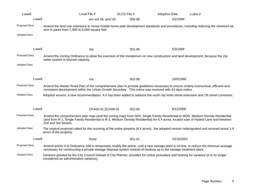
LUBA #Adoption DateLocal File # DLCD File #Lowellrev ord 38, artcl 29 005-98Lowell 2/2/1999
Adopted Desc.
Amend the land use ordinance to revise mobile home park development standards and procedures, including reducing the minimum lot size in parks from 7,000 to 6,000 square feet.
Proposed Desc.
n/a 001-99Lowell 5/3/1999
Adopted Desc.
Amend the Zoning Ordinance to allow the exension of the moratorium on new construction and land development, because the city water system is beyond capacity.
Proposed Desc.
n/a 002-99Lowell 10/5/1999
Adopted version: a new recommendation, 4.6 has been added to address the north city limits street extension and 7th street connector.Adopted Desc.
Amend the Master Road Plan of the comprehensive plan to provide guidelines necessary to ensure orderly economical, efficient and consistent development within the Urban Growth Boundary. This notice was received with 43 days notice.
Proposed Desc.
CPA00-01;ZCH00-01 002-00Lowell 9/12/2000
The original proposal called for the rezoning of the entire porperty (6.4 acres). the adopted version redesignated and rezoned anout 1-9acres of the property.
Adopted Desc.
Amend the comprehensive plan map (and the zoning map) from SFR, Single Family Residential to MDR, Medium Density Residential (and from R-1, Single Family Residential to R-3, Medium Density Residential) for 6.4 acres, located east of Hyland Lane and between 2nd and 3rd Streets.
Proposed Desc.
None 001-01Lowell 10/16/2001
Variance granted by the City Council instead of City Planner; provides for notice procedure and hearing for variance (it is no longer considered an administrative variance).
Adopted Desc.
Amend article II of Ordinance 168 to temporarily modify the article, until a new sewage plant is on-line, to reduce the minmum acreage necessary for constructing a private sewage disposal system instead of hooking up to the sewage treatment plant.
Proposed Desc.
Page Number : 3

LUBA #Adoption DateLocal File # DLCD File #LowellMoratorium 002-01Lowell 1/29/2002
Same.Adopted Desc.
Amend the comprehensive plan to adopt a moratorium on the waste water treatment plant controlling the timing and sequencing of development within the City according to available sewer capacity; and adopt a moratorium on new construction or new land development in the City.
Proposed Desc.
Moratorium 003-02Lowell 7/25/2002
Adopted Desc.
Amend the comprehensive plan to adopt an extension to the moratorium on the waste water treatment plant, controlling the timing and sequencing of development within the City according to available sewer capacity; and adopt a extension to the moratorium on new construction or new land development in the City. The original moratorium was adopted on January 29, 2002 under DLCD File No. 002-01.
Proposed Desc.
None 001-02Lowell 12/3/2002
The adopted ordinance makes bed and breakfasts conditional uses, provides for sign restrictions, requires an annual health inspection and requires that off-street parking access and egress meet fire district requirements.
Adopted Desc.
Amend the zoning ordinance Article 28-General Provisions: Definitions, and Section 6.02(k) adding "Bed and Breakfast" as a definition and as a permitted use in the Single Family Residential District. The city has declared an emergency.
Proposed Desc.
004-02Lowell 1/21/2003
Same.Adopted Desc.
Amend the comprehensive plan to adopt an extension to the moratorium on the waste water treatment plant, controlling the timing and sequencing of development within the City according to available sewer capacity; and adopt a extension to the moratorium on new construction or new land development in the City. The original moratorium was adopted on January 29, 2002 under DLCD File No. 002-01. The second moratorium was adopted on July 25, 2002 under DLCD File No. 003-02.
Proposed Desc.
Page Number : 4

LUBA #Adoption DateLocal File # DLCD File #OakridgeN/A 001-87AOakridge 7/7/1988
FLOODPLAIN REGULATIONS.Adopted Desc.
Amend the zoning ordinance's floodplain regulations to conform with revised Federal Emergency Management Agency regulations. Also, add provisions regarding planned unit developments, neighborhood commercial uses, and public hearing procedures. In addition, incorporate various related ordinances, such as the sign code, into the zoning ordinance.
Proposed Desc.
NA 001-88Oakridge 2/2/1989
EXPANDS THE UGB AND INCLUDES AN EXCEPTION.Adopted Desc.
Amend the Oakridge Urban Growth Boundary to add 100 acres located north of High Prairie Road and south of McFarland Road. The proposal includes an exception.
Proposed Desc.
PA 3020-88 001-89Oakridge 3/21/1989
Lane County adoption.Adopted Desc.
Amend the Lane County Rural Comprehensive Plan to expand the Oakridge UGB and rezone approximately 100 acres from F-2 (Impacted Forest) and RR-10/RCP (Rural Residential 10 units per acre) to RR-10/U (Rural Residential 10 units per acre) located adjacent to the northern boundary of Oakridge and south of McFarland Road. The proposal includes an exception.
Proposed Desc.
PR 002-90Oakridge 4/26/1990
PERIODIC REVIEW-PLAN UPDATE.Adopted Desc.
Amend the comprehensive plan and zoning ordinance to make changes related to the periodic review update.Proposed Desc.
PA 93-01 001-93Oakridge 9/16/1993
Adopted Desc.
Amend the comprehensive plan to allow noncontiguous annexation in cases where the septic or water system of a developed residential property within the urban growth boundary has failed.
Proposed Desc.
Page Number : 1

LUBA #Adoption DateLocal File # DLCD File #OakridgeNA 002-93Oakridge 9/16/1993
Add public facility overlay to 11 acres.Adopted Desc.
Amend the zoning ordinance to add a Public Facility zone within the city. Add the public facility overlay district to approximately 11.0 acres located near Highway 58 and in the southeast portion of the city.
Proposed Desc.
NA 004-93Oakridge 11/4/1993
Adopted Desc.
Amend the comprehensive plan to add lanugage for residential and commercial land uses appropriate for the area south of Salmon Creek, in the vicinity of Highway 58 and the area known as old Rigdon Ranger Station.
Proposed Desc.
NA 003-93Oakridge 11/4/1993
Adopted Desc.
Amend the zoning ordinance to establish a Park, Recreation, Open Space zone to the code.Proposed Desc.
TSP 001-00Oakridge 10/5/2000
The city will amend their land division Ordinance No. 805 and zoning ordinance 809 at a subsequent hearing to bring them into compliance with the TSP.
Adopted Desc.
Amend the comprehensive plan to adopt the Transportation System Plan and replace Section 11-Transportation of Section III: Goals and Objectives; and replace Polices, Street Functional Classifications and Standards in section A.-Transportation of Section V.; add and delete text to the following sections of the land division ordinance no. 805: Article 1-Introductory Provisions, Article 3-Subdivision Tentative Plan, Article 4-Final Subdivision Plat, Article 5-Land Partitions, Article 6-Design Standards, Article 7-Improvements Requirements, Article 8-General Provisions; add and delete text to the following sections of the land division ordinance no. 809: Article 4-Low Density Residential District (R-1), Article 5-Medium Density Residential District (R-2), Article 7-Central Commercial District (C-2), Article 20- Off-Street Parking, Article 21-Access Management And Vision Clearance, Article 25-Site Plan Review Permits, Article 33-Definitions.
Proposed Desc.
Page Number : 2

LUBA #Adoption DateLocal File # DLCD File #OakridgeTSP 001-00Oakridge 12/7/2000
Ordinance language has been refined to provide clarity and direction for roadway access and alignment, intersection angles, cul de sacs, use of planting strips, and for when access management is applied. Other minor revisions, such as spelling and punctuation changes have been amde.
Adopted Desc.
Amend the comprehensive plan to adopt the Transportation System Plan and replace Section 11-Transportation of Section III: Goals and Objectives; and replace Polices, Street Functional Classifications and Standards in section A.-Transportation of Section V.; add and delete text to the following sections of the land division ordinance no. 805: Article 1-Introductory Provisions, Article 3-Subdivision Tentative Plan, Article 4-Final Subdivision Plat, Article 5-Land Partitions, Article 6-Design Standards, Article 7-Improvements Requirements, Article 8-General Provisions; add and delete text to the following sections of the land division ordinance no. 809: Article 4-Low Density Residential District (R-1), Article 5-Medium Density Residential District (R-2), Article 7-Central Commercial District (C-2), Article 20- Off-Street Parking, Article 21-Access Management And Vision Clearance, Article 25-Site Plan Review Permits, Article 33-Definitions.
Proposed Desc.
Page Number : 3

LUBA #Adoption DateLocal File # DLCD File #SpringfieldLRP2004-00005 003-04Springfield 7/6/0200
There were a number of test and format revisions based on public oral and written testimony and from the Planning Commission.Adopted Desc.
Amend Article 21 - ( CI ) Campus Industrial Zoning District of the zoning ordinance in seven areas to make it consistent with the Metro Plan, by adding and deleting definitions, establish operational performance standards, establish a prohibited use list, establish a development limitation for business parks, and other guidelines. The area involve contains approximately 330.00 acres, and is located in the Gateway Properties CI District and the Pierce Properties CI District.
Proposed Desc.
87-01-07 005-87ASpringfield 3/2/1987
Adopted Desc.
Amend the Mid Springfield Refinement Plan from Community Commercial to Heavy Industrial and Light Medium Industrial for approximately 15 acres located at the northwest and southwest corners of Main Street and 32nd. The amendment is proposed to correspond with Metro plan designations for the parcels.
Proposed Desc.
86-11-65 001-87ASpringfield 3/16/1987
Adopted Desc.
Adoption of the Q Street Refinement Plan, a requirement of the Metropolitan Area General Plan.Proposed Desc.
87-01-03 002-87ASpringfield 4/6/1987
AMEND THE METROPOLITAN AREA GENERAL PLAN TO BE CONSISTENT WITH THE Q STREET REFINEMENT PLAN.
Adopted Desc.
Amend the Metropolitan Area General Plan to conform with the Q Street Refinement Plan's designations for approximately 40 acres. The proposals would generally increase residential densities except for one 11.8 acre area that is proposed for redesignation from High Density Residential to Commercial.
Proposed Desc.
87-03-2G 007-87ASpringfield 5/4/1987
DOWNTOWN REFINEMENT PLAN.Adopted Desc.
Amend the Downtown Refinement Plan to include a street design plan for Main Street and South A Street.Proposed Desc.
Page Number : 1

LUBA #Adoption DateLocal File # DLCD File #Springfield87-01-05 004-87ASpringfield 5/6/1987
AMEND THE PLAN MAP FROM LOW DENSITY RESIDENTIAL TO PARKS AND OPEN SPACE.Adopted Desc.
Amend the comprehensive plan from Low Density Residential to Parks and Open Space for 31 acres located at N. 62nd and Thurston Road.
Proposed Desc.
87-01-04 003-87ASpringfield 5/6/1987
AMEND THE METROPOLITAN AREA GENERAL PLAN MAP TO BE CONSISTENT WITH THE DESIGNATION CRITERIA CONTAINED IN THE REFINEMENT PLAN.
Adopted Desc.
See <PA>PA.TRACKSHEETS.3, page 20 - 21 for more informationProposed Desc.
88-11-192 005-88Springfield 3/6/1989
Adopted Desc.
Amend the zoning ordinance to allow minor housekeeping changes regarding: 1) formal interpertations of plan provision; 2) day care; 3) site plan review; 4) sidewalks in subdivision; and 5) signs.
Proposed Desc.
#89-04-61 002-89Springfield 6/5/1989
Adopted Desc.
Amend the comprehensive plan from MDR (Medium Density Residential) to Mixed Use Area 2 and zoning from MDR (Medium Density Residential) and LDR (Low Density Residential) to CC (Community Commercial District) and HDR (High Density Residential) for approximately 0.75 acre located at south 47th and Main Streets.
Proposed Desc.
90-09 143 004-90Springfield 2/4/1991
Adopted Desc.
Amend the Development Code to comply with local, state and federal regulations and include a series of housekeeping changes.
Proposed Desc.
Page Number : 2

LUBA #Adoption DateLocal File # DLCD File #Springfield91-01-08 009-91Springfield 4/15/1991
Revise Solar Access OrdinanceAdopted Desc.
Update the Solar Access Ordinance.Proposed Desc.
91-02-28 002-91Springfield 5/20/1991
Adopted Desc.
Amend the Development Code to revise site design and development standards for Special Light Industrial (SLI) zone.Proposed Desc.
MA 93-4 004-93Springfield 5/17/1993
Airport Reserve to Airport overlay. w/exception. ADOPTED BY SPRINGFIELD 5/17/93, ADOPTED BY EUGENE 5/6-17/93.
Adopted Desc.
Amend the comprehensive plan from Airport Reserve to Government and Education and zoning from E-40/CAS (ExclusiveFarm Use/Commercial Airport Safety) to AO/CAS (Airport Operations/Airport Safety) for 20.0 acres located on the south side of Airport Road, west of Green Hill Road. The proposal includes an exception.
Proposed Desc.
93-01-12 002-93Springfield 5/17/1993
Adopted Desc.
Amend the comprehensive plan from Agricultural to Low Density Residential and zoning from E-30 (Exclusive Farm Use) to Low Density Residential for 3.67 acres located at the 3900 block of Hayden Bridge Road. This proposal includes an exception.
Proposed Desc.
93-04-63 002-93Springfield 7/6/1993
Adopted Desc.
Amend the comprehensive plan and zoning from Special Light Industrial to Community Commercial for 3.5 acres located north of International Way. The proposal was submitted without text.
Proposed Desc.
Page Number : 3

LUBA #Adoption DateLocal File # DLCD File #Springfield95-06-117 001-95Springfield 8/8/1995
Adopted Desc.
Urban Service Agreement for fire and emergency services between the city and Willakenzie Rural Fire Protection District specifying delivery of services, financing, and review.
Proposed Desc.
95-06-117 002-95Springfield 8/8/1995
Adopted Desc.
Intergovernmental agreement pertaining to transit services specifying how the city and Lane County will exchange information, define planning roles and responsibilities concerning land use ordinances, development, routing and scheduling, and other services pertaining to urban services. Provides for modification and review.
Proposed Desc.
95-06-117 003-95Springfield 8/8/1995
Adopted Desc.
Intergovernmental agreement for coordinated planning for fire protection services between the city and Rainbow Water District.
Proposed Desc.
95-06-117 004-95Springfield 8/8/1995
Adopted Desc.
Urban services agreement among Rainbow Water District, city utility board, and the city pertaining to operations, financing, capital debt, planning and coordination, construction, review, and modification.
Proposed Desc.
95-06-117 005-95Springfield 8/8/1995
Adopted Desc.
Intergovernmental agreement regarding coordinated planning and urban services between Willamalane Park and Recreation District, Land County, and the city.
Proposed Desc.
Page Number : 4

LUBA #Adoption DateLocal File # DLCD File #Springfield95-06-117 006-95Springfield 8/8/1995
Adopted Desc.
Intergovernmental agreement regarding cooperative planning for water services among Lane County, Springfield Utility Board, Rainbow Water District, and the city to establish exchange of information, planning roles and responsibilities, participation in land use actions and ordinances, and review and modification.
Proposed Desc.
Jo No 99-08-194 006-99Springfield 10/18/1999
Same.Adopted Desc.
Amend the zoning map from LDR, Low Density Residential to NC, Neighborhood Commecial for 1.48 acres, located on the SE corner of 72nd Street and Main Street. This proposal was received without text.
Proposed Desc.
99-07-172 005-99Springfield 10/18/1999
Same.Adopted Desc.
Amend the zoning map from LDR, Low Density Residential to MDR, Medium Density Residential for 1.0 acre, located on the westside of South 59th Street and South "A" Street.
Proposed Desc.
1999-02-0041/1999... 004-99Springfield 11/8/1999
Same.Adopted Desc.
Amend the comprehensive plan and zoning maps from AG, Agriculture to NR, Natural Resources; AG, Agriculture to PLO, Public Lands and Open Spaces for 34.58 acres, located south of the northwest corner of the urban growth boundary and adjacent to Interstate 5 and Sports Way; to expand the urban growth boundary to include the 34.58 acres. 18 acres will be developed as a Regional Sports Facility and 16.5 acres will be preserved and protected as a Natural Resource zone. This proposal was received with 42 days before the first evidentiary hearing.
Proposed Desc.
1999.08.0198 003-99Springfield 11/8/1999
Adopted version language revised section 5.070 of Development Code.Adopted Desc.
Amend the development code to adopt the Glenwood Refinement Plan and adopt revisions from the Glenwood Planning Advisory Committee. This proposal was received with 42 days notice before the first evidentiary hearing.
Proposed Desc.
Page Number : 5

LUBA #Adoption DateLocal File # DLCD File #Springfield1999-09-0230 008-99Springfield 12/6/1999
Same.Adopted Desc.
Amend the Mid-Springfield Refinement Plan Diagram and zoning map from LDR, Low Density Residential to LMI, Light Medium Industrial for 0.15 acres, located at 3504 "E" Street; and a lot line adjustment of 74 feet and move the line to the south to comply with current use.
Proposed Desc.
99-08-197, 99-08-209 009-99Springfield 12/6/1999
Same.Adopted Desc.
Amend article 7 section 7.030 of the development code to: (1) make the City the Home City of all site specific Type I and II Metro Plan amendments east of Interstate 5, and add the jurisdictional responsibility of Glenwood for Metro plan amendments and declaring an emergency; and (2) provide for hearing by the Lane County Hearings Official of all: quasi-judicial land use requests outside the city limits but inside the Urban Growth Boundary not considered in conjunction with annexation to the city; and appeals of decision of the director of the development services department outside the city limits but inside the Urban Growth Boundary; and appeals of expeditedland division actions as defined in ORS 197.360. This proposal was received with 40 days notice, before the first evidentiary hearing.
Proposed Desc.
1999-09-0244 010-99Springfield 12/7/1999
Same.Adopted Desc.
Amend the zoning map (and the east main refinement plan) from CC, Community Commercial to HDR, High Density Residential/Mixed Use (and from CC, Community Commercial to High Density Residential) for 3.578 acres, located at South 49th and Main Street. This proposal was received without a final hearing date.
Proposed Desc.
2000-03-0055 001-00Springfield 6/19/2000
Adopted amendments changed to say that planter strips on all arterials and public streets have a minimum width of 4.5 feet. Adopted Desc.
Amend the development code to create development standards or multi-unit development within the Medium and High Density Residential Districts by adding text and sections to the following: Article 2, Definitions-to revise Section 2.020 "BUILDING HEIGHT" and DEVELOPABLE ACRE"; Article 10, Discretionary Uses-to add Section 10.035 to provide procedures allowing for certain adjustments to the multi-unit design standards at the Planning Commission level; Article 11, Variances and Modifications of Provisions-to add Section 11.035 to provide procedures allowing for certain adjustments to the multi-unit design standards at the staff level; Article 16, Residential Zoning Districts-to revise Section 16.050 multi-unit setback standards; Article 16-to revise Section 16.060 to increase height in Medium and High Density Residential to 35 feet and 50 feet in some cases in High Density; Article 16-to revise Section 16.090(1) multi-unit parking standards; Article 16-to add Section 16.110 Design Standards categories for multi-unit developments; Article 31, Minimum Development Standards and Site Plan Review Standards-to revise Section 31.140 referencing parking lot planting standards; Article 31-to revise Section 31.160 referencing multi-unit screening standards; Article 31-to revise Section 31.180 allowing a sidewalk or planted area to be widened instead of providing wheel stops; Article 31-to revise Section 31.190(9) allowing bike racks to be installed in landscaped areas in multi-unit development only; Article 32, Public and Private improvements to revise Section 32.040(1) to allow for flexibility of design for accessways; Article 32, Table 32-1 to establish a 20 foot-wide alley standard. This proposal was received withoutnotice of a final hearing date.
Proposed Desc.
Page Number : 6

LUBA #Adoption DateLocal File # DLCD File #Springfield2000-12-0244 008-00Springfield 12/4/2000
Same.Adopted Desc.
Amend the municipal code to add a new Section 2.900, "Regulatory Takings" in 14 subsections dealing with claims relating to regulations affecting real property to comply with Ballot Measure 7 (BM 7), and declaring an emergency. This proposal was received after the first evidentiary hearing of December 4, 2000.
Proposed Desc.
2000-09-0195 004-00Springfield 12/13/2000
The UF-10 applies to all land outside of the city limits, but within the UGB. The subject property is in this area.Adopted Desc.
Amend the zoning map from LDR, Low Density Residential to CC, Community Commercial; and LMI, Light Medium Industrial to CC, Community Commercial for 2.86 acres, located at 4446 Franklin Boulevard. Amend the Metro Plan and the Glenwood Refinement Planto reflect the changes in the zoning map. This proposal was received without text, and without notice of a final hearing.
Proposed Desc.
00-10-210 007-00Springfield 1/17/2001
Same.Adopted Desc.
Amend the zoning map from LDR, Low Density Residential to MDR, Medium Density Residential for 0.61 acres, located on the south side of Main Street (McKenzie Highway) west of South 63rd Street. This proposal was received without notice of a final hearing, which will be determined at a later date.
Proposed Desc.
2000-10-214 006-00Springfield 1/17/2001
Same.Adopted Desc.
Amend the zoning map from LDR, Low Density Residential to CC, Community Commercial for 0.13 acres, located on the west side of 35th Street, 110 feet north of Mckenzie Highway to eliminate the Plan/Zone conflict and bring the property into agreement with the above plans. This proposal was received with 40 days notice before the first evidentiary hearing, and without a notice of a final hearing date.
Proposed Desc.
NA 003-00Springfield 2/6/2001
Same.Adopted Desc.
Amend the development code that relates to bicycle parking and circulation by adopting and implementing portions of the Springfield Bicycle Plan, to require long-term sheltered for bicycle parking; separated bicycle parking from vehicle parking; clarifies and illustrates installation location standards for bicycle racks on development sites; requires showers and change rooms for new businesses that have a large number of employees; and alters the existing accessway and bike/pedestrian trail standards so that they comply with Statewide Goal 12. This proposal was received with 43 days notice before the first evidentiary hearing date.
Proposed Desc.
Page Number : 7

LUBA #Adoption DateLocal File # DLCD File #SpringfieldPA 99-5599 007-99Springfield 3/19/2001
Site Review Suffix added to the zone changes.Adopted Desc.
Amend the comprehensive plan map (and zoning map) from AG, Agriculture to RS, Residential (and from EFU-40, Exclusive Farm Use-40 to RR-5, Non-Resource Rural Residential) for 12.5 acres, located at the southwest corner of Royal Avenue and Greenhill Road. This proposal is a combined notice with the City of Eugene # 004-99 and Lane County #012-99, and includes an exception.
Proposed Desc.
Jo. No. 2001-02-0031 002-01Springfield 3/22/2001
Same.Adopted Desc.
Amend the zoning map from PL, Public Lands to IH, Heavy Industrial; and OS, Open Space to IH, Heavy Industrial for 2.00 acres, located at 201 South 18th Street. This proposal was received with 18 days notice before the first evidentiary hearing, and without noticeof a final hearing.
Proposed Desc.
20001-03-0052 004-01Springfield 4/17/2001
Same.Adopted Desc.
Amend the zoning map from GO, General Office to CC, Community Commercial for 3.00 acres, located on the north side of Highway 126 at 5846 Main Street. This proposal was received with 35 days notice before the first evidentiary hearing, and without notice of a final hearing.
Proposed Desc.
2001-03-040 003-01Springfield 4/19/2001
Same.Adopted Desc.
Amend the zoning map from LDR, Low Density Residential to HDR, High Density Residential to eliminate the conflict between the comprehensive plan and the current zoning for 23 parcels on 12.16 acres, located on the north side of "Q" Street, on the west side of 7th Street, on the south side of EWEB Path and on the east side of Pioneer Parkway. This proposal was received with 43 days notice before the first evidentiary hearing.
Proposed Desc.
00-12-249/00-12-249 001-01Springfield 5/1/2001
Same.Adopted Desc.
Amend the comprehensive plan and zoning maps from CI, Campus Industrial to CC, Community Commercial for 9.51 acres, located north of Marcola Road, east of 27th Street, and west of 28th Street.
Proposed Desc.
Page Number : 8

LUBA #Adoption DateLocal File # DLCD File #SpringfieldZ 001-05-0107 006-01Springfield 6/19/2001
Same.Adopted Desc.
Amend the zoning map from LDR, Low Density Residential to MRC, Major Retail Commercial for one parcel; and LDR, Low Density Residential to GO, General Office for three parcels on 12.60 acres, located at 1460 "G" Street. Amend the zoning ordinance Article 28, Hospital Support Overlay zone to allow the following: residential or skilled care facilities as a special use, rather than a discretionary use; low-rise parking garages as an outright use; and a broader list of medical-related, retail and service businesses. This proposal was received with 33 days notice before the first evidentiary hearing.
Proposed Desc.
Z 001-05-0107 006-01ASpringfield 7/16/2001
Same.Adopted Desc.
Amend the zoning map from LDR, Low Density Residential to MRC, Major Retail Commercial for one parcel; and LDR, Low Density Residential to GO, General Office for three parcels on 12.60 acres, located at 1460 "G" Street. Amend the zoning ordinance Article 28, Hospital Support Overlay zone to allow the following: residential or skilled care facilities as a special use, rather than a discretionary use; low-rise parking garages as an outright use; and a broader list of medical-related, retail and service businesses. This proposal was received with 33 days notice before the first evidentiary hearing.
Proposed Desc.
2001-05-108 007-01Springfield 7/17/2001
Same.Adopted Desc.
Amend the zoning map from MDR, Medium Density Residential to NC, Neighborhood Commercial for approximately 0.75 acre portion of a 1.82 acre parcel, located on the south side of Main Street, and one parcel east of S. 59th Street. This proposal was received without notice of a final hearing.
Proposed Desc.
2001-09-0192 009-01Springfield 4/1/2002
Same.Adopted Desc.
Amend the development code in the following areas: Article 2: "Definitions", to include Wellness Centers; and Article 23: "Public Land and Open Space" to allow Wellness Centers as a special use, secondary to a primary use and subject to specific standards; and conform with the Metro Plan. This proposal was received without notice of a final hearing.
Proposed Desc.
005-01Springfield 6/3/2002
The adopted amendment contains changes stemming form citizen input, additional staff and review and council direction.Adopted Desc.
Amend the development code to add Article 40: Springfield Mixed-Use Zoning Districts consisting of thirteen sections and Article 41: Nodal Development Overlay District consisting of eight sections, to establish mixed-use development zoning and nodal development overlay districts.
Proposed Desc.
Page Number : 9

LUBA #Adoption DateLocal File # DLCD File #Springfield004-02Springfield 7/1/2002
Same.Adopted Desc.
Amend the zoning and subdivision ordinances to add Cluster Developments and Accessory Dwelling Units by revising the standards to allow more flexibility, allow a variety of housing types in Low Density Residential Districts, streamline the review process, encourage small lot development, compatiblity with surrounding neighborhoods, encourage higher densities development area, design specifications for streets, sidewalks, curbs, parking, open space, and drainage. This proposal was received with 42 days notice before the first evidentiary hearing.
Proposed Desc.
2002-02-0038 001-02Springfield 7/15/2002
The text and findings contained in the staff report were revised to clarify Goals 5 and 6 applicability issues with intent that future development will be closer to compliance with the Clean Water Act and the Safe Drinking Water Act.
Adopted Desc.
Amend the development code to adopt interim minimum development standards and procedures in a multi-phased task ( Phase 1 of 4 Phases ) as part of the City's overall Endangered Species Act ( ESA ) compliance strategy. Phase 1 is the foundation upon which the remaining phases will be based. Phases 1 include revising in part, the following six Articles: 1-General Provisions, 2-Definitions, 31- Minimum Development Standards and Site Plan Review Standards, 32-Public and Private Improvements, 34-Partition Standards, and 35-Subdivision Standards.
Proposed Desc.
2002-02-032 002-02Springfield 7/15/2002
SAME.Adopted Desc.
Amend the bicycle plan and map to add 2,000 feet of a multi-use path, along 42nd Street from Olympic to the railroad tracks and along the west side of the Kaiser Slough. This proposal was received without text, and without notice of a final hearing date. Revised Notice: The fist evidentiary heaing has been changed from June 14, 2002 to June 18, 2002.
Proposed Desc.
2002-07-0200 009-02Springfield 10/7/2002
The original notice stated that the plan designation would be changed to Mixed Use. The adopted plan designation is Commercial/Mixed Use.
Adopted Desc.
Amend the Comprehensive Plan Map to amend the East Main Refinement Plan Diagram to designation from Medium Density Residential (MDR) to Mixed Used Area 2 (MU) on .36 acres located south of the intersection of 47th and Main Street. This proposal was received without notice of a final hearing date. Related DLCD file 008-02 regarding the correlating zone map change.
Proposed Desc.
Page Number : 10

LUBA #Adoption DateLocal File # DLCD File #Springfield2002-07-0201 008-02Springfield 10/7/2002
Originally the applicant proposd a Zone Change for two tax lots to Mixed Use Employment. Following evaluation of Metro Plan and East Refinement Plan Policies along with the City Councils direction on a plan for implementation of the Mixed Use District Zoning Districts, staff recommended that only tax lot 2100 would be rezoned to CC.
Adopted Desc.
Amend the Zoning Map from Community Commercial (CC) and Medium Density Residential (MDR) to Mixed Use Employment (MUE) on .72 acres located south of 47th and Main Street in order to operate a light-industrial use with possible residential or commercial future usage. This proposal was received without notice of a final hearing date. Related DLCD file 009-02 regarding East Main Refinement Plan amendment.
Proposed Desc.
Jo. No. 02-04-119 005-02Springfield 10/7/2002
Same.Adopted Desc.
Amend the Springfield Drinking Water Protection Plan adopted in 1999, to update the DWP plan to include the surface water management area on the Middle Fork Willamette River the original DWP included ground water only.
Proposed Desc.
02-08-245 010-02Springfield 10/15/2002
Same.Adopted Desc.
Amend the Drinking Water Protection Plan text and map to modify the Drinking Water Protection Areas as certified by State of Oregon Department of Human Services, Health Divison / Drinking Water Program certification number 0002R. Weyerhaeuser Wellfield Drinking Water Protection Overlay Zone will include approximately 481 new properties.
Proposed Desc.
2002-09-8306 013-02Springfield 11/18/2002
Same.Adopted Desc.
Amend the development code to add "transit station" to permitted uses in the Booth Kelly Zoning District, and exempt transit station from the 200 foot setback from residences required for bus terminals and heliports.
Proposed Desc.
2002-03-0063 007-02Springfield 12/9/2002
SameAdopted Desc.
Amend the comprehensive plan and zoning map from Light-Medium Industrial to Commercial; from Light-Medium Industrial to Parks; and from Light-Medium Industrial to Open Space; from Heavy Industrial to Commercial; from Heavy Industrial to Parks; from Heavy Industrial to Open Space for 35.00 acres, located south of Main Street, between 28th and 32nd Streets. The proposal is for a new development where the north 6.00 acres will be mixed use, and the rest will be developed with an indoor sports facility, a sports administration office, and 5 soccer fields. This proposal was received with 43 days notice before the first evidentary hearing, and is related to DLCD File No. 006-02 and Local File No. 2002-03-062.
Proposed Desc.
Page Number : 11

LUBA #Adoption DateLocal File # DLCD File #Springfield2002-03-0062 006-02Springfield 12/9/2002
Same.Adopted Desc.
Amend the comprehensive plan and zoning maps from Public Land to Campus Industrial for a portion of tax Lot 1000; and from Commercial to Campus Industrial for Tax Lot 100 for a total of 30.00 acres, of a 40.00 acre site, located in the Gateway Area, east of Interstate 5, and west of Sports Way at the end of the street. The proposal is to rezone 22.00 acres for future development of a Campus Industrial Complex, and the north 18.00 acres (Tax Lot 1000) would remain in City ownership and retain its Park and Open Space designation. This proposal was received with 43 days notice before the first evidentary hearing, and is related to DLCD File No. 007-02 and Local File No. 2002-03-063.
Proposed Desc.
ZON 2002-10-350 016-02Springfield 1/7/2003
One additional property was added (ODOT, 0.12 acre, 17-03-25-31 Tl 5700)Adopted Desc.
Amend the zoning map from CC, Community Commercial to MRC, Major Retail Commercial for 0.50 acre, located at 1657 Mohawk Boulevard to be consistent with the Metro Plan. This proposal was received without notice of a final hearing date.
Proposed Desc.
ZON 2002-12427 004-03Springfield 4/1/2003
Same.Adopted Desc.
Amend the zoning map from Low Density Residential to Medium Density Residential for approximately 2.50 acres, located south of Mohawk Road and west of 22nd Street. This proposal was received without notice of a final hearing.
Proposed Desc.
2002-08-244 014-02Springfield 4/21/2003
Same. Various changes to policies as directed by the Planning Commission and Council.Adopted Desc.
Amend the Gateway Refinement Plan text to allow siting of a hospital in Medical Services Zone, and to enable the submittal of a master plan in conformance with the development code. Amend the refinement plan map from CC, Community Commercial (33 Acres) to MUC, Mixed Use Commercial (33 acres) for 93.00 acres, located in the Gateway Area of North Springfield. This proposal was received without notice of a final hearing.
Proposed Desc.
2002-08-224 012-02Springfield 4/21/2003
Same.Adopted Desc.
Amend the comprehensive plan map from Medium Density Residential (MDR) to Community Commercial (CC) on 33.00 acres located at the Gateway area of North Springfield. Also, amend the comprehensive plan map from Community Commercial (CC) to Mixed Use Commercial, also allow for the siting of a hospital on Medical Services (MS) zoning.
Proposed Desc.
Page Number : 12

LUBA #Adoption DateLocal File # DLCD File #Springfield2002-08-243 015-02Springfield 4/25/2003
Same.Adopted Desc.
Amend the Metro Plan Diagram from MDR, Medium Density Residential to CC, Community Commercial for 33.00 acres, located in the Gateway Area of North Springfield. This proposal was received without text, and without notice of a final hearing date.
Proposed Desc.
LRP 2002-12431 003-03Springfield 7/7/2003
Same.Adopted Desc.
Amend the Gateway Refinement Plan Map (and the zoning map) from Medium Density Residential to Neighborhood Commercial (and from MDR, Medium Density Residential to NC, Neighborhood Commercial) for 1.20 acres, located on the south side of Harlow Road , and west of Laura Street at 433 and 449 Harlow Road. Revised notice: The first evidentiary hearing has been changed from April 1, 2003 to May 6, 2003, and the final hearing has been changed from April 21, 2003 to May 19, 2003.
Proposed Desc.
LRP2002-12429 006-03Springfield 7/7/2003
Changed designation to mixed use instead of Commercial (Mixed use Area 3).Adopted Desc.
Amend the comprehensive plan map from LDR, Low Density Residential to CC, Community Commercial for 0.28 acre, located at 52nd Place and Main Street to develop the land into a medical and commercial building complex.
Proposed Desc.
LRP 2003-00012 008-03Springfield 7/14/2003
The adopted ordinance is for the Detour bridge only; the original proposed amendment was for the detour bridge and the replacement bridge.
Adopted Desc.
Amend the Metro Area General Plan to allow an exception to Statewide Planning Goal 15 - Willamette River Greenway, to allow placingfill within the Willamette River Greenway setback for a detour bridge on the east side of the Interstate-5 highway bridge for approximately 1800 feet and south over the Willamette River. The detour bridge is needed to divert traffic away from the Willamette River Bridge, which is beyond repair and will be replaced. This proposal was received with 29 days notice before the first evidentiary hearing and without notice of a final hearing. Revised Notice: The original notice was received without a final hearing date, which has been set as Wednesday, June 18, 2003.
Proposed Desc.
ZON2002-12432 005-03Springfield 7/15/2003
Proposed Amendment stated zone change from MDR to CC, final adoption was changed from Medium Density Residential to Neighborhood Commercial.
Adopted Desc.
Amend the zoning map from MDR, Medium Density Residential to NC, Neighborhood Community Commercial for 1.20 acres to develop a children's museum and entertainment center. The parcel is located at 433 and 449 Harlow Road.
Proposed Desc.
Page Number : 13

LUBA #Adoption DateLocal File # DLCD File #SpringfieldLRP 2003-00017 009-03Springfield 7/21/2003
There were minor text amendments and a fee was added for Type II Serial Property Line Adjustments.Adopted Desc.
Amend the development code in the following areas: (1) Article 2 - Definitions by adding and deleting text in the following terms: Parcel, Lot Line Adjustment, Property Line Adjustment, Replat, and Relocation; (2) Article 3 - Development Approval and Land Use Decision Procedures by adding and deleting text to Subsection 3.040 - The Pre-Application Conference; (3) Article 33 - Lot Line Adjustment Standards delete this section in its entirety and replace it with a new "Article 33 - Property Line Adjustment Standards" consisting of nine subsections; (4) add a new section "Article 42 - Replat Standards" consisting of five subsections.
Proposed Desc.
LRP 2003-00009 007-03Springfield 11/3/2003
The amendment is the same in its substantive content, but was modified form the original notice. The revised language more clearly defines auto dealerships to include automobile and light trucks.
Adopted Desc.
Amend Article 40 - Mixed Use Zoning Districts of the development code to grandfather existing auto dealerships within the Downtown Mixed Use area of the Downtown Refinement Plan, where the zone is applied. Revised Notice: The revised proposal changes the first evidentiary hearing from July 15, 2003 to September 16, 2003, and the final hearing from July 15, 2003 to October 6, 2003.
Proposed Desc.
ZON 2003-00038 010-03Springfield 11/4/2003
Same.Adopted Desc.
Amend the zoning map from Low Density Residential to CC, Community Commercial to bring the map into compliance with the refinement plan designation for 0.28 acre, located on the east side of 52nd Street between Main Street to the north and Daisy Street to the south.
Proposed Desc.
LRP2003-00024 011-03Springfield 12/1/2003
Same.Adopted Desc.
Amend the zoning code to allow the director to waive "Site Plan Review" for duplex and single family developments on Medium or High Density Residential lots of 20,000 square feet or less, that can only accommodate one such dwelling and/or for development that includes additions or remodels to existing duplex or single family dwellings on such lots.
Proposed Desc.
ZON 2004-00001 001-04Springfield 4/6/2004
Same.Adopted Desc.
Amend the zoning map to match the Eugene Springfield Metro Plan designation from LMI, Light Medium Industrial to HI, Heavy Industrial for ten tax lots on 11.50 acres, located at 470 South Second Street. The Borden Chemical Company has been on the site since the 1940's.
Proposed Desc.
Page Number : 14

LUBA #Adoption DateLocal File # DLCD File #SpringfieldZON 2004-00005 002-04Springfield 5/18/2004
Same.Adopted Desc.
Amend the zoning map from Heavy Industrial to Public Land and Open Space for approximately 2.00 acres, located at 3985 and 3995 Marcola Road. The site is currently developed as a non-profit organization called the "The Child Center."
Proposed Desc.
Page Number : 15

LUBA #Adoption DateLocal File # DLCD File #VenetaCP-1-87 001-87AVeneta 4/13/1987
FLOODPLAIN REGULATIONS TO CONFORM WITH FEMA REQUIREMENTS.Adopted Desc.
Amend the zoning ordinance's floodplain regulations to conform with revised Federal Emergency Management Agency regulations.
Proposed Desc.
Ord. 179 001-88Veneta 1/12/1988
CHANGES TO LAND DIVISION ORDINANCE WHICH REVISE REVIEW AND APPEAL PROCEDURES, ADDRESS EASEMENT CONCERNS AND GENERALLY BRING THE ORDINANCE INTO CONFORMANCE WITH CHAPTER 92 OREGON REVISED STATUTES.
Adopted Desc.
Amend the zoning ordinance to: 1) eliminate requirement that subdivisions above the 450-foot elevation comply with PUD procedures; 2) amend filing of final plats and final partition maps; 3) amend minor partition application requirements; and 4) reduce standard street width from 36 feet to 32 feet paving width.
Proposed Desc.
Ord. 178 002-88Veneta 1/12/1988
AMENDMENTS TO LAND DEVELOPMENT ORDINANCE ADDRESSING CONCERNS RAISED DURING PERIODICREVIEW AND OTHER CHANGES OF A CLEAN-UP NATURE.
Adopted Desc.
Amend the zoning ordinance to: 1) allow public/semi-public uses as outright uses instead of conditional uses in the RR, SFR and GR residential zones; 2) delete solar access provisions in the SFR and GR yard requirements; 3) increase GR density for multi-family buildings; 4) delete quarries, solid waste disposal sites and junk yard uses in the IC zone and delete special yard requirements in the LI zone. SEE PA.TRACKSHEET for more information.
Proposed Desc.
CP/ZC 3-90 003-90Veneta 1/26/1990
Adopted Desc.
Amend the comprehensive plan and zoning from Industrial to Commercial on approximately 1 acre located on the southside of Highway 126 and Territorial Road.
Proposed Desc.
PR 001-89Veneta 8/27/1990
Adopted Desc.
Amend the comprehensive plan and zoning ordinance to make changes related to the periodic review update.Proposed Desc.
Page Number : 1

LUBA #Adoption DateLocal File # DLCD File #VenetaCP/ZC 2-90 002-90Veneta 11/26/1990
Adopted Desc.
Amend the comprehensive plan and zoning from Commercial to Commercial/Residential for several properties totalling 32.02 acres.
Proposed Desc.
NA 001-92Veneta 3/23/1992
Adopted Desc.
Amend the land division ordinance to provide for regulation of property line adjustments in accordance with 1991 state legis1ation regarding subdivision, partitions and property line adjustments.
Proposed Desc.
CP/ZC 2-92 003-92Veneta 7/27/1992
Adopted Desc.
Amend the comprehensive plan from RR (Rural Residential) to M (Medium Density General Residential) and zoning from RR (Rural Residential) to GR (General Residential) for 16.14 acres located on Bolton Hill Road.
Proposed Desc.
ZC-3-92 004-92Veneta 11/9/1992
Allow placement of manufactured housing.Adopted Desc.
Amend the Land Development Ordinance definition of single- family dwelling to allow placement of manufactured housingin all zones where stick built homes are allowed.
Proposed Desc.
NA 001-94Veneta 4/11/1995
Adopted Desc.
Amend the zoning ordinance to allow accessory buildings in excess of 500 square feet in the rural residential zone on parcels one acre or larger. Subject to conditional use permit conditions. The proposal was submitted without text.
Proposed Desc.
Page Number : 2

LUBA #Adoption DateLocal File # DLCD File #VenetaCP/ZC-1-95 001-95Veneta 9/11/1995
Adopted Desc.
Amend the zoning map from General Residential to Commercial for 1.44 acres located at 87774 Territorial and 87754 Territorial Road.
Proposed Desc.
Res. 693 001-96Veneta 3/11/1996
Adopted Desc.
Amend the land use regulations to create a temporary construction moratorium within city limits as a result of sewer system having reached zero hydraulic capacity.
Proposed Desc.
CP/ZC-1-96 002-96Veneta 12/9/1996
Adopted Desc.
Amend the Land Development Ordinance to revise numerous items including public notice requirements; zones allowing junkyards, shake mills, and repair shops, mobile home park annual licensing; and reorganization of text. This proposal was received with 42 days notice.
Proposed Desc.
tree removal 003-98Veneta 9/28/1998
Adopted Desc.
Amend the land use ordinance text to revise tree removal regulations.Proposed Desc.
TSP 001-98Veneta 11/9/1998
Adopted Desc.
Amend the comprehensivej plan text to adopt the Transportation System Plan.Proposed Desc.
Page Number : 3

LUBA #Adoption DateLocal File # DLCD File #VenetaTSP 001-98BVeneta 11/9/1998
Adopted Desc.
Amend the comprehensivej plan text to adopt the Transportation System Plan.Proposed Desc.
TSP 001-98AVeneta 12/9/1998
Adopted Desc.
Amend the comprehensivej plan text to adopt the Transportation System Plan.Proposed Desc.
surety bond 004-98Veneta 1/25/1999
Adopted Desc.
Amend the land division ordinance to include a surety bond requirement in conjunction with an improvement agreement, add an optional review step for subdivisions prior to the Planning Commission meeting at which their preliminary plan will be considered, and make minor language amendments to make the land division ordinance and the land development ordinance more consistent in defining process and notice requirements.
Proposed Desc.
N/A 001-99Veneta 5/10/1999
The adoption closely follows the Federal Emergency Management Agency model ordinance.Adopted Desc.
Amend the Land Development Ordinance and zoning map, from Flood Plain Subzone to New Firm-Based Subzone, and the section language relating to flooding, manufacture home anchoring and enclosed areas. This notice received with 42 days notice.
Proposed Desc.
Page Number : 4

LUBA #Adoption DateLocal File # DLCD File #VenetaCP/ZC-2-02 002-02Veneta 8/26/2002
Text amendments to the land development ordinance were not included in the hearings due to the extensive notice required Adopted Desc.
Amend the comprehensive plan map from Parks to General Residential and Open Space/Greenway for two half parcels on 14.00 acres; Parks to Commercial for 0.19 acre; Single Family Residential to Public for 0.22 acre; General Residential and Open Space/Greenway Overlay to Industrial-Commercial for two parcels on 0.46 acre; General Residential to Single Family Residential for two parcels on 9.76 acres. Amend the zoning map from Public Facilities and Park to General Residential and Open Space/Greenway Overlay zone for two half parcels on 14.00 acres; Public Facilities and Park to Community Commercial for 0.19 acre; Single Family Residential-8000 Square feet to Public Facilities and Parks for 0.22 acre; Highway Commercial to Community Commercial for six parcels on 12.65 acres; General Residential and Greenway subzone to Industrial-Commercial for two parcels on 0.46 acre; General Residential to Single Family Residential-8,000 Square Feet for two parcels on 9.76 acres. The parcels are located in six areas throughout the City. Amend the land division ordinance 418-Articles 3 and 4 to require addition signatures on property line adjustments,land partitions, and subdivision final plats before filing the map.
Proposed Desc.
CP/ZC-1-02 001-02Veneta 8/26/2002
Amendments to the text and maps in the comprehensive plan, land development ordinance, and the transportation system plan to address the traffic impacts the zone change will have.
Adopted Desc.
Amend the comprehensive plan map (and the zoning map) from Industrial to Industrial/Commmercial (and from Medium Industrial to Industrial/Commercial) for two parcels on 6.40 acres, located on the north side of State Highway 126, east of Hope Lane and south of Jeans Road; and develop the two parcels into a subdivision of eight lots for a mix of industrial, commercial, and industrial-commercial tenants. Revised Notice: Amend the Transportation System Plan to support the proposed land uses in the above notice by adding to TSP Map 9, Proposed Streets; revise the text description of the Jeans/Territorial intersection; add and delete text in seven other areas of the TSP. Amend the comprehensive plan text to include Cornerstone Drive as a major collector. Amend the northeast employment center specific development plan an element of the zoning ordinance, to add text dealing with transportation issues.
Proposed Desc.
CP/ZC-1-02 001-02AVeneta 9/23/2002
Language clarification for amendments to the text an maps in the comprehensive plan, land development ordinance and transportation system plan to address the traffic impacts the zone change will have.
Adopted Desc.
Amend the comprehensive plan map (and the zoning map) from Industrial to Industrial/Commmercial (and from Medium Industrial to Industrial/Commercial) for two parcels on 6.40 acres, located on the north side of State Highway 126, east of Hope Lane and south of Jeans Road; and develop the two parcels into a subdivision of eight lots for a mix of industrial, commercial, and industrial-commercial tenants. Revised Notice: Amend the Transportation System Plan to support the proposed land uses in the above notice by adding to TSP Map 9, Proposed Streets; revise the text description of the Jeans/Territorial intersection; add and delete text in seven other areas of the TSP. Amend the comprehensive plan text to include Cornerstone Drive as a major collector. Amend the northeast employment center specific development plan an element of the zoning ordinance, to add text dealing with transportation issues.
Proposed Desc.
Page Number : 5

LUBA #Adoption DateLocal File # DLCD File #WestfirPeriodic Rev 001-88Westfir 12/29/1988
PERIODIC REVIEW PLAN UPDATE.Adopted Desc.
Amend the comprehensive plan and zoning ordinance to make changes related to the periodic review plan update.Proposed Desc.
Ordinance 80 001-94Westfir 4/11/1994
Adopted Desc.
Amend the zoning ordinance to comply with the state law (HB 2835) relating to the placement of manufactured housing.Proposed Desc.
manufact. hm. defin. 001-98Westfir 12/14/1998
Adopted Desc.
Amend the zoning ordinance to revise the definition of "manufactured home or dwelling" and to specify the conditions for their allowance outside of manufactured dwelling parks.
Proposed Desc.
NA 001-04Westfir 11/8/2004
Same.Adopted Desc.
Adopt a new "Westfir Community Facilities Master Plan" as an element of the comprehensive plan.Proposed Desc.
Page Number : 1

LUBA #Adoption DateLocal File # DLCD File #Eugene/SpringfieldN/A 003-87AEugene/Springfield 8/13/1986
Adopted Desc.
Amend the Eugene-Springfield Metro Plan to incorporate a public facilities plan. The plan is required to be adopted as part of the communities' periodic review plan update pursuant to OAR 660 Division 11.
Proposed Desc.
MPA 87-1 001-87AEugene/Springfield 3/9/1987
Adopted Desc.
Amend the Metro Plan policies to delete the requirements that noncontiguous annexations must be limited to developed urban land and processed by the triple majority approval process.
Proposed Desc.
1987-01-10 002-87AEugene/Springfield 3/16/1987
ESTABLISHES PROCESS FOR SEMI ANNUAL CITIZEN INITIATED CHANGES TO THE METRO PLAN. ADOPTED BY ALL THREE JURIS.
Adopted Desc.
Amend the Eugene-Springfield Metro Plan to add a section providing standards and a process for amendments to the Metro Plan.
Proposed Desc.
1987-01-10 002-87AEugene/Springfield 4/13/1987
Adopted Desc.
Amend the Eugene-Springfield Metro Plan to add a section providing standards and a process for amendments to the Metro Plan.
Proposed Desc.
N/A 003-87AEugene/Springfield 4/27/1987
ADOPTION OF A PUBLIC FACILITIES PLAN.Adopted Desc.
Amend the Eugene-Springfield Metro Plan to incorporate a public facilities plan. The plan is required to be adopted as part of the communities' periodic review plan update pursuant to OAR 660 Division 11.
Proposed Desc.
Page Number : 1

LUBA #Adoption DateLocal File # DLCD File #Eugene/SpringfieldN/A 004-87AEugene/Springfield 5/20/1987
AMENDS THE METROPOLITAN AREA GENERAL PLAN TO MAKE IT CONSISTENT WITH THE TRANSPLAN,PUBLIC FACILITES PLAN AND PERIODIC REVIEW ORDER.
Adopted Desc.
Amend the Eugene/Springfield Metro Plan (TransPlan, Public Facilities Elements and Plan Diagram) to adopt specific transportation projects contained in the Central Area Transportation Study.
Proposed Desc.
Ord. PA 941 010-87BEugene/Springfield 5/27/1987
AMEND EUGENE/SPRINGFIELD METRO AREA PUBLIC FACILITES PLAN TO DETERMINE JURISDICTIONAL RESPONSIBILITY FOR DRAINAGE IMPROVEMENTS IN CEDAR CK BASIN AND ADOPTPUBLIC FACILITY PLAN (EUGENE) THAT IS CONSISTENT WITH METRO PLAN.
Adopted Desc.
Amend the Eugene/Springfield Metropolitan Area Public Facilities Plan to: 1) determine jurisdictional responsibility for drainage improvements in Cedar Creek basin; and 2) adopt a Public Facility Plan on this issue that is consistent with the Eugene/Springfield Metropolitan Area Public Facilities Plan.
Proposed Desc.
N/A 003-87AEugene/Springfield 6/1/1987
Adopted Desc.
Amend the Eugene-Springfield Metro Plan to incorporate a public facilities plan. The plan is required to be adopted as part of the communities' periodic review plan update pursuant to OAR 660 Division 11.
Proposed Desc.
CA 87-7 006-87AEugene/Springfield 7/27/1987
ADOPTION OF STANDARDS FOR GOVERNMENT INITIATED AMENDMENTS TO THE METRO PLAN.Adopted Desc.
Amend the Metro Plan policies to adopt guidelines for government-initiated amendments to the Metro plan.Proposed Desc.
CA 87-4 005-87AEugene/Springfield 7/27/1987
ADD CHANGE IN PUBLIC POLICY AS A FACTOR IN AMENDING THE METRO PLAN.Adopted Desc.
Amend the Metro Plan policies to add "change in Public Policy" to the list of criteria for evaluation proposed plan amendments.
Proposed Desc.
Page Number : 2

LUBA #Adoption DateLocal File # DLCD File #Eugene/SpringfieldPA 933 007-87BEugene/Springfield 8/26/1987
Adopted Desc.
Amend the comprehensive plan to require that annexation of land that is contiguous to city limits be supported by owners of at least one-half of the area.
Proposed Desc.
PA 933 007-87BEugene/Springfield 8/26/1987
REVISE A GROWTH MANAGEMENT AND USA POLICY TO REQUIRE THAT NON-CONTIGUOUS ANNEXATIONS BE SUPPORTED BY OWNERS OF 1/2 OF THE AREA.
Adopted Desc.
Amend the comprehensive plan to require that annexation of land that is contiguous to city limits be supported by owners of at least one-half of the area.
Proposed Desc.
MPA 87-1 001-87AEugene/Springfield 9/16/1987
Adopted Desc.
Amend the Metro Plan policies to delete the requirements that noncontiguous annexations must be limited to developed urban land and processed by the triple majority approval process.
Proposed Desc.
MPA 87-1 001-87AEugene/Springfield 10/19/1987
ADDS A HISTORIC OVERLAY DISTRICT TO THE SPRINGFIELD DEVEL. CODE AND APPLIES THE ZONE TO THE WASHBURNE HISTORIC DISTRICT DONE TO COMPLY WITH METROPOLITAN AREA PLAN.
Adopted Desc.
Amend the Metro Plan policies to delete the requirements that noncontiguous annexations must be limited to developed urban land and processed by the triple majority approval process.
Proposed Desc.
PA 933 007-87BEugene/Springfield 10/21/1987
Adopted Desc.
Amend the comprehensive plan to require that annexation of land that is contiguous to city limits be supported by owners of at least one-half of the area.
Proposed Desc.
Page Number : 3

LUBA #Adoption DateLocal File # DLCD File #Eugene/SpringfieldMA 87-3 009-87BEugene/Springfield 10/28/1987
Adopted Desc.
Amend the comprehensive plan from Medium Density Residential to Commercial for approximately 10.4 acres located on the north side of Green Acres Road, east of N. Delta Highway.
Proposed Desc.
Ord. 16-87 013-87BEugene/Springfield 11/25/1987
AMENDMENTS COVER URBANIZABLE AREA ADMINISTERED BY EUGENE TO ASSURE THAT MOBILE HOMES ARE ALLOWED IN /MH ZONES AND ALLOW CONTINUED USE OF MOBILE HOMES IN HARDSHIP SITUATIONS.
Adopted Desc.
Amend the zoning ordinance to: 1) assure that lots and parcels under the Lane County MH zone are eligible for mobile homes; and 2) allow continued use of mobile homes in hardship situations.
Proposed Desc.
MA 87-4 008-87BEugene/Springfield 12/7/1987
Adopted Desc.
Amend the comprehensive plan from Light-Medium Industrial to Commercial for approximately 16.8 acres located at the northeast corner of West 11th and Bailey Hill Road.
Proposed Desc.
N/A 004-87AEugene/Springfield 12/7/1987
Adopted Desc.
Amend the Eugene/Springfield Metro Plan (TransPlan, Public Facilities Elements and Plan Diagram) to adopt specific transportation projects contained in the Central Area Transportation Study.
Proposed Desc.
88-01-12 001-88Eugene/Springfield 3/25/1988
TO INCORPORATE THE EAST MAIN REFINEMENT PLAN FOR THE CITY OF SPRINGFIELD. ADOPTIONBY SPRINGFIELD.
Adopted Desc.
Adopt the East Main Refinement Plan as an element of the Eugene/Springfield Metropolitan Area Plan.Proposed Desc.
Page Number : 4

LUBA #Adoption DateLocal File # DLCD File #Eugene/Springfield88-01-12 001-88Eugene/Springfield 4/4/1988
TO INCORPORATE THE EAST MAIN REFINEMENT PLAN FOR THE CITY OF SPRINGFIELD. ADOPTIONBY LANE COUNTY
Adopted Desc.
Adopt the East Main Refinement Plan as an element of the Eugene/Springfield Metropolitan Area Plan.Proposed Desc.
88-01-12 001-88Eugene/Springfield 6/22/1988
TO INCORPORATE THE EAST MAIN REFINEMENT PLAN TO THE CITY OF SPRINGFIELD. ADOPTION BY EUGENE.
Adopted Desc.
Adopt the East Main Refinement Plan as an element of the Eugene/Springfield Metropolitan Area Plan.Proposed Desc.
Ord. PA 957 004-88Eugene/Springfield 5/10/1989
PROVIDE PROCEDURES FOR FUTURE AMENDMENTS TO RIVER ROAD/SANTA CLARA URBAN FACILITIESPLAN.
Adopted Desc.
NOTE: This was previously proposed as Lane County amendment #007-88 and has a revised hearing date.Proposed Desc.
Ord. PA 957 004-88Eugene/Springfield 5/24/1989
PROVIDE PROCEDURES FOR FUTURE AMENDMENTS TO RIVER ROAD/SANTA CLARA URBAN FACILITIESPLAN.
Adopted Desc.
NOTE: This was previously proposed as Lane County amendment #007-88 and has a revised hearing date.Proposed Desc.
Ord. Pa 003-89Eugene/Springfield 5/31/1989
ADOPT EUGENE/SPRINGFIELD DEVELOPMENT CODE.Adopted Desc.
NOTE: THE PROPOSAL HAS A NEW HEARING DATE.Proposed Desc.
Page Number : 5

LUBA #Adoption DateLocal File # DLCD File #Eugene/SpringfieldOrd. PA 957 004-88Eugene/Springfield 8/14/1989
PROVIDE PROCEDURES FOR FUTURE AMENDMENTS TO RIVER ROAD/SANTA CLARA URBAN FACILITIESPLAN.
Adopted Desc.
NOTE: This was previously proposed as Lane County amendment #007-88 and has a revised hearing date.Proposed Desc.
MA 87-6 012-87BEugene/Springfield 9/25/1989
INCLUDES EXCEPTION TO GOALS 3 AND 14. EXPANDS CITY OF EUGENE'S UGB TO PROVIDE FOR LARGE SITE HEAVY INDUSTRIAL USE FOR 200 ACRES.
Adopted Desc.
Amend the comprehensive plan from Agricultural to Special Heavy Industrial and zoning from Exclusive Farm Use to Special Heavy Industrial for 200 acres located north of Awbrey Lane. Amend the comprehensive plan to adopt related textual changes to the Economy Element. The proposal will expand the Urban Growth Boundary and includes an exception to Goal 3. NOTE: This a revised proposal.
Proposed Desc.
MA 87-6 012-87BEugene/Springfield 10/18/1989
INCLUDES EXCEPTION TO GOALS 3 AND 14. EXPANDS CITY OF EUGENE'S UBG TO PROVIDE FOR LARGE SITE HEAVY INDUSTRIAL USE FOR 200 ACRES.
Adopted Desc.
Amend the comprehensive plan from Agricultural to Special Heavy Industrial and zoning from Exclusive Farm Use to Special Heavy Industrial for 200 acres located north of Awbrey Lane. Amend the comprehensive plan to adopt related textual changes to the Economy Element. The proposal will expand the Urban Growth Boundary and includes an exception to Goal 3. NOTE: This a revised proposal.
Proposed Desc.
MA 87-6 012-87BEugene/Springfield 10/23/1989
INCLUDES EXCEPTION TO GOALS 3 AND 14. EXPANDS CITY OF EUGENE'S UGB TO PROVIDE FOR LARGE SITE HEAVY INDUSTRIAL USE FOR 200 ACRES.
Adopted Desc.
Amend the comprehensive plan from Agricultural to Special Heavy Industrial and zoning from Exclusive Farm Use to Special Heavy Industrial for 200 acres located north of Awbrey Lane. Amend the comprehensive plan to adopt related textual changes to the Economy Element. The proposal will expand the Urban Growth Boundary and includes an exception to Goal 3. NOTE: This a revised proposal.
Proposed Desc.
Page Number : 6

LUBA #Adoption DateLocal File # DLCD File #Eugene/SpringfieldPA 11-89/12 007-89Eugene/Springfield 11/21/1989
EXTEND THE AUTHORITY FROM LANE CO TO EUGENE AND SPRINGFIELD TO APPLY THEIR LAND USEAND BUILDING REGULATIONS TO CROSS OF UGB EXPANSIONS WHERE THE METRO PLAN HAS BE AMENDED. ADOPTION BY LANE COUNTY.
Adopted Desc.
Amend the comprehensive plan and Lane County zoning ordinance to extend authority to the Cityies of Eugene and Springfield to administrate their land use regulation and building regulations within county areas of the UGB.
Proposed Desc.
NA 004-89Eugene/Springfield 3/28/1990
DEFINITIONS OF HEAVY INDUSTRIAL, LIGHT-MEDIUM INDUSTRIAL AND SPECIAL LIGHT INDUSTRIL IN EUGENE-SPRINGFIELD METRO AREA GENERAL PLAN. ADOPTED BY LANE COUNTY.
Adopted Desc.
Amend the Eugene/Springfield Metropolitan Area General Plan to simplify language and insure consistiney for Special Light Industrial, Light-Medium Industrial, and Heavy Industrial land use designations.
Proposed Desc.
ORD.4-90 002-90Eugene/Springfield 4/25/1990
AMEND THE ZONING CODE TO REGULATE TIMBER REMOVAL WITHIN THE UGB. ADOPTED BY LANE COUNTY.
Adopted Desc.
Amend the zoning code to regulate timber removal within the urban growth boundary.Proposed Desc.
MA 89-2 001-90Eugene/Springfield 6/13/1990
AMEND THE PLAN TO LONGER REQUIRE ANNEXATION AS A PREREQUISITE FOR SEWER SERVICE TO DEVELOPED PROPERTIES IN THE RIVER ROAD AND SANTA CLARA AREA, THIS IS IN RESPONSE TOA DEQ/EPA MANDATE TO REDUCE GROUND WATER POLUTION.
Adopted Desc.
Amend the comprehensive plan to no longer require annexation as a prerequisite for sewer service to developed properties in the River Road and Santa Clara area. This proposal is in response to a DEQ/EPA mandate to reduce ground water polution.
Proposed Desc.
90095
NA 003-90Eugene/Springfield 6/20/1990
ALLOW AMATEUR RADIO ANTENNAS AS A PERMITTED USE IN THE RESIDENTIAL AREAS.Adopted Desc.
Amend the zoning ordinance to allow amateur radio antennas as a permitted use in residential areas.Proposed Desc.
Page Number : 7

LUBA #Adoption DateLocal File # DLCD File #Eugene/Springfield88-08-137 003-88Eugene/Springfield 6/26/1990
Amend the metro plan pertaining to the types of activities on lands designated for certain industrial uses.Adopted Desc.
NOTE: This is a revised propsal.Proposed Desc.
NA 006-90Eugene/Springfield 7/25/1990
AMEND THE EUG/SPRIN/METRO PLAN TO CONFORM WITH THE GLENWOOD REFINEMENT PLAN.Adopted Desc.
Amend the comprehensive plan to adopt the Glenwood Refinement Plan which addresses goals, policies and implementation strategies for land use planning, transportation, public facilities, and environmental design.
Proposed Desc.
MA 90-1 005-90Eugene/Springfield 7/25/1990
CHANGES TO 154 ACRES LOCATED IN THE GLENWOOD REFINEMENT PLAN.Adopted Desc.
Amend the comprehensive plan and zoning to adopt several changes for 154 acres located in the Glenwood Refinement Plan.
Proposed Desc.
NA 004-90Eugene/Springfield 10/29/1990
Adopted by Eugene 10/29/90, Springfield 11/19/90, and Lane County 10/29/90.Adopted Desc.
Amend Chapter IV of the Metro Plan to streamline the amendment process by allowing minor amendments to be initiated at any time and provide the opportunity for a single jurisdiction to approve a minor plan amendment.
Proposed Desc.
NA 007-90Eugene/Springfield 10/29/1990
Adopted by Eugene 10/29/90, Springfield 11/19/90, and Lane County 10/29/90.Adopted Desc.
Amend the comprehensive plan to replace the MAPACA (Metropolitan Area General Planning Advisory Committee) with the JPCC (Joint Planning Commission Committee) and remove the requirements that proposed plan amendments be reviewed by the citizen advisory committee.
Proposed Desc.
Page Number : 8

LUBA #Adoption DateLocal File # DLCD File #Eugene/SpringfieldNA 006-89Eugene/Springfield 11/19/1990
Same.Adopted Desc.
Amend the comprehensive plan to divide amendments into minor and major categories and provide for unilateral or joint adoption for some minor amendments.
Proposed Desc.
MA 89-3 009-90Eugene/Springfield 2/27/1991
North of Stewart Road, East of Bertelsen Road, Between Enid Road and Awbrey Lane, East of Highway 99.
Adopted Desc.
Amend the comprehensive plan from: SEE PA LONG TRACK SHEETS IN THE PA DIRECTORY.Proposed Desc.
91-11-177 002-91Eugene/Springfield 5/6/1991
County Sand and Gravel to Metro Light-Medium Industrial and Natural Resource.Adopted Desc.
Amend the comprehensive plan and zoning from Sand and Gravel to Light-Medium Industrial and City Quarry Mining for 75.03 acres located at the end of 52nd Street, north of High Banks Road, and south of the McKenzie River. The proposal includes an exception.
Proposed Desc.
90-12-201 001-91Eugene/Springfield 9/9/1991
This was adopted by Springfield 9/9/91. This was adopted by Lane County 10/1/92.Adopted Desc.
Amend the comprehensive plan and zoning from Light Medium and Heavy Industrial to Medium Density Residential and Light-Medium Industrial and Commercial for 52.9 acres located between North 28th and North 32nd on the North side of Main Street.
Proposed Desc.
MA 89-3 009-90Eugene/Springfield 9/25/1991
Lane County adoption 10/04/91.Adopted Desc.
Amend the comprehensive plan from: SEE PA LONG TRACK SHEETS IN THE PA DIRECTORY.Proposed Desc.
Page Number : 9

LUBA #Adoption DateLocal File # DLCD File #Eugene/SpringfieldWetlands 002-92Eugene/Springfield 7/22/1992
Adopt-the West Eugene Wetlands Plan. Adopted by Eugene 9/28/92, Lane County 8/4/92.Adopted Desc.
Amend the comprehensive plan to adopt the West Eugene Wetlands Plan, a refinement plan to the Eugene-Springfield Metropolitan Area General Plan.
Proposed Desc.
MA 91-001 007-92Eugene/Springfield 8/26/1992
Willakenze Area Plan.Adopted Desc.
Adopt the Willakenzie Area Plan, a "refinement plan" of the Eugene-Springfield Metro Area General Plan. The plan coversthe nine square mile Willakenzie Planning Area in Eugene. Several elements of the Metro Plan will be amended simultaneously to assure consistency, including the Transporttion Plan and Public Facilities Plan, and the amendment will supercede Goodpasture Island and Coburg Crescent special area plans.
Proposed Desc.
NA 004-91Eugene/Springfield 9/1/1992
Lane County adoption only.Adopted Desc.
Adoption of the Gateway Refinement Plan, includes amendments to the TransPlan and the Public Facilities Plan. The Gateway area includes Resential, commercial and Industrial areas in the Willamette Greenway.
Proposed Desc.
NA 001-92Eugene/Springfield 10/21/1992
Adopted Desc.
Amend the comprehensive plan to approve the Metropolitan Industrial Lands Special Study Inventory and Policy Recommendations Report and adopt the associated amendments to the Metropolitan Area General Plan text.
Proposed Desc.
NA 004-91Eugene/Springfield 11/9/1992
Adopted Desc.
Adoption of the Gateway Refinement Plan, includes amendments to the TransPlan and the Public Facilities Plan. The Gateway area includes Resential, commercial and Industrial areas in the Willamette Greenway.
Proposed Desc.
Page Number : 10

LUBA #Adoption DateLocal File # DLCD File #Eugene/SpringfieldMA 92-2 008-92Eugene/Springfield 12/9/1992
Adopted by Eugene and Lane County-Dec 9, 1992; Springfield on December 14, 1992.Adopted Desc.
Amend the comprehensive plan and zoning from UL/1-2 (Light Medium Industrial) to R-1 (Low Density Residential) for 78 acres located east of the Northwest Expressway, north of Beltline Road and south of Irving Road.
Proposed Desc.
MA 91-001 007-92Eugene/Springfield 3/18/1993
Adopted previously, this adoption is an addition to the Willakenzie Eugene and Gateway neighborhoods.Adopted Desc.
Adopt the Willakenzie Area Plan, a "refinement plan" of the Eugene-Springfield Metro Area General Plan. The plan coversthe nine square mile Willakenzie Planning Area in Eugene. Several elements of the Metro Plan will be amended simultaneously to assure consistency, including the Transporttion Plan and Public Facilities Plan, and the amendment will supercede Goodpasture Island and Coburg Crescent special area plans.
Proposed Desc.
MA 92-5 003-93Eugene/Springfield 5/17/1993
Adopted Desc.
Amend the comprehensive plan from Parks and Open Spaces to Low Density Residential and zoning from from F-2 (Forest Lands) to RA/UL (Suburban Residential) for 0.72 acre located on the east side of Spring Boulevard. This amendment is proposed to rectify an error that was improperly issued. Also this proposal includes an exception.
Proposed Desc.
1998-09-0199 001-98Eugene/Springfield 12/7/1998
Adopted Desc.
Amend the Metro Area General Plan to transfer the jurisdiction of the unincorporated community of Glenwood from Eugene to Springfield.
Proposed Desc.
Eugene RA 99-06 002-99Eugene/Springfield 11/3/1999
Same.Adopted Desc.
Amend the metropolitan area general plan to repeal the 1986 Alton Baker Park Master Plan requested by the City of Eugene and replace it with the 1996 East Alton Baker Park Plan and the 1997 West Alton Baker Park Development Plan. This proposal was received with 44 days notice.
Proposed Desc.
Page Number : 11

LUBA #Adoption DateLocal File # DLCD File #Eugene/SpringfieldRA 99-5; MA 99-1 004-99Eugene/Springfield 3/8/2000
(1) Addition of a new Appendix D-Property Acquistion-compensation; and (2) amendments to the Plan Section on Airport Parking and circulation to emphasize consideration of policies related to alternative modes in calculating future parking requirements.
Adopted Desc.
Amend the Metro Plan to adopt the 1999 Eugene Airport Master Plan and update the Lane County Zoning Map to reflect the following changes: amend the Eugene-Springfield Transportation Plan to add the Green Hill Road Realignment; the Public Facilities Plan to implement the 1999 Eugene Airport Master Plan. Amend the comprehensive plan map (and the zoning map) from AG, Agriculture to G, Government and Education; AR, Airport Reserve to G, Government and Education; RC, Rural Commercial to G, Government and Education (and from E-40, Exclusive Farm Use-40 to AO/CAS, Airport Operations/Commercial Combining Zone; and RC, Rural Commercial to AO/CAS, Airport Operations/Combining Zone) for 26 parcels located partially or entirely within the Airport Boundary and approximately 10 miles northwest of downtown Eugene, west of Highway 99. This proposal was received after the first evidentiary hearing of July 6, 1999.
Proposed Desc.
Ordinance No. 10-00 001-00Eugene/Springfield 12/13/2000
Same.Adopted Desc.
Amend the Springfield Municipal Code Chapter 2, "Government and Administration", Section 2.90 in 13 subsections and the Eugene Code, 1971 renumbering Section 2.030 to 2.150 and 2.070 to 2.170 and add new Sections 2.040, 2.045, 2.050, 2.055, 2.060, 2.065 dealing with real property compensation application process for the properties located with the Urban Growth Boundary of the Eugene/Springfield Metro Plan to comply with Ballot Measure 7 (BM7), and Metro declares an emergency. These provisions include the possiblity of discontinuing to apply regulations. This proposal was received with 13 days notice before the first evidentiary hearing.
Proposed Desc.
Ordinance #1132 001-99Eugene/Springfield 10/31/2001
Amendment adds performance measures approved by LCDC, policies and a schedule of action required to acheive requirements for an integrated Land Use/Transportation Plan as specified in the TPR, additional policies relating to Eugene, removal of some road projects, addition of some planning projects, and errata. 2 copies of the plan are attached in legislative format, showing the changes between the May 1999 draft and the adopted version of the plan. The adoption has no postmark, it was handcarried to DLCD.
Adopted Desc.
Amend the Eugene-Springfield Metro Area General Plan: (1) to be consistent with the proposed findings and policies of the Transportation Plan; and (2) update the Transportation System Plan by adopting new goals, policies, and the 20-Year Financially constrained Capital Investment Action Project lists. This proposal was received with 44 days notice. This proposal includes an exception.
Proposed Desc.
See Summary for Nos. 001-02Eugene/Springfield 7/31/2002
Trans Plan Amendments: revisions to amendments required for conformance with the amendments to the 20-year financially-constrained project list, as attached. West Eugene Wetlands Plan amendments: no change.
Adopted Desc.
Amend the area Transportation System Plan ( TSP ), area general plan, Lane County Rural Comprehensive Plan, and the West Eugene Wetlands Plan to construct the West Eugene Parkway a proposed four-lane limited access highway with bike lanes, located between State Highway 99W and Garfield Street in the City of Eugene and the Oak Hills area west of Eugene in rural Lane County. This proposal includes exceptions to the following Statewide Planning Goals: 3-Agricultural Lands, 4-Forest Lands, 11-Public Facilities and Services, and 14-Urbanization that will generally effect only portions of sixteen tax lots. The local file No. is Eugene File Nos: RA 02-1, MA 02-1, RA 02-2. Remanded back to Metro under LUBA Appeal Nos. 2002-105, 112, 113, 114, 115, 116 on 03/24/2003.
Proposed Desc.
Page Number : 12

LUBA #Adoption DateLocal File # DLCD File #Eugene/SpringfieldMA 02-7, Z 02-10 002-02Eugene/Springfield 2/24/2003
Same.Adopted Desc.
Amend the Eugene/Springfield Metro Plan Map to add the ND Nodal Development Plan Map designation. Amend the Bethel-Danebo Refinement Plan Map and the Royal-Danebo Development Node Map to depict the entire Danebo nodal development area. Rezone property within the Danebo Area to add the ND Nodal Development Overlay zone to the base zones. Amend the comprehensive plan map from LDR, Low Density Residential; MDR, Medium Density Residential; C, Commercial to LDR/ND, Low Density Residential/NodalDevelopment; MDR/ND, Medium Density Residential/Nodal Development; C/ND, Commercial/Nodal Development. Amend the zoning map from AG, Agriculture; R-1, Low Density Residential; R-2, Medium Density Residential; C-2, General Commercial To AG/ND, Agriculture/Nodal Development, R-1, Low Density Residential/Nodal Development; R-2/ND, Medium Density Residential/Nodal Development, C-2/ND, General Commercial/Nodal Development. The acreage involved is 149.00 and is located north and south of Royal Avenue; west and east of Danebo.
Proposed Desc.
EF MA 02-9, Z 02-12 003-02Eugene/Springfield 2/26/2003
Same.Adopted Desc.
Amend the plan map to add the Nodal Development Plan map designation for property within the Cresent Nodal Development Area, by changing LDR, Low Density Residential; MDR, Medium Density Residential; HDR, High Density Residential; C, Commercial; CI, Commercial Industrial To LDR/ND, Low Density Residential/Nodal Development; MDR/ND, Medium Density Residential/Nodal Development; HDR/ND, High Density Residential/Nodal Development; C/ND, Commercial/Nodal Development; CI/ND, Commercial Industrial/Nodal Development. Amend the zoning map from R-1, Low Density Residential; R-2, Medium Density Residential; R-4, High Density Residential; C-1, Neighborhood Commercial; C-2, General Commercial; GO, General Office; I-1, Campus Industrial To R-1/ND, Low Density Residential/Nodal Develoment; R-2/ND, Medium Density Residential/Nodal Development; R-4/ND, High Density Residential/Nodal Development; C-1/ND, Neighborhood Commercial/Nodal Development; C-2/ND, General Commercial/Nodal Devlopment; GO/ND, General Office/Nodal Development; I-1/ND, Campus Industrial/Nodal Development. The total number of acreage involved is 138.00 and is located north and south of Cresent Avenue and east of Coburg Road. Amend the Willakenzie refinement plan land use diagram and subarea diagrams to depict the Cresent Area to add the /ND Nodal Devlopment overlay zone to the base zones.This proposal was received without text.
Proposed Desc.
MA 02-8; Z 02-11 004-02Eugene/Springfield 5/14/2003
Since a portion of the Lower River Road nodal development area is within the boudary of the Whiteaker Plan, the concurrent automatic amendment to refinement plan maps included amendment to both the River Road-Santa Clara Urban Facilities Plan and Whiteaker Plan Land Use diagrams.
Adopted Desc.
Amend the Metro Plan Map adding the ND Nodal Development Plan Map designation to the base Metro Plan designations for property within the Lower River Road nodal development area. Amend the River Road Santa Clara Urban Facilities Plan ( refinement plan ) to add the ND Nodal development overlay zone to the base zones. Amend the plan map from LDR, Low Density Residential; MDR, Medium Density Residential; C, Commercial; Parks and Open Space to LDR/ND, Low Density Residential with Nodal Development Overlay; MDR/ND, Medium Density Residential with Nodal Development Overlay; C/ND, Commercial with Nodal Development Overlay; Parks and Open Space with Nodal Development Overlay for 67.00 acres. Amend the zoning map from R-1 to R-1/ND; R-2 to R-2/ND; C-2 to C-2/ND; PL to PL/ND; and S-H to S-H/ND for 67.00 acres. The location of the area involved is east of River Road and generally between Stults Street and Thompson Street in the City of Eugene. This proposal was received without text. Revised Notice: The date of the final hearing has been changed from April 16, 2003 to April 9, 2003.
Proposed Desc.
Page Number : 13

LUBA #Adoption DateLocal File # DLCD File #Eugene/SpringfieldMA 03-7, RA 03-5.... 003-03Eugene/Springfield 3/8/2004
The proposed Metro Plan amendment is unchanged. The initial Fairmount/ U of O Special Area Study amendments proposed 3 policy revisions; The adopted amendments include those 3 policies and added 10 new policies. The initial code amendment added three new sections not previously proposed. Amend the metro plan map from High, Medium and Low Density Residential to Government and Education; Refinement Plan from General Institutional to Institutional and Low Density Residential was added.
Adopted Desc.
Amend the Metro Plan Diagram, Fairmount/U of O Diagram, and Eugene Code to implement the East Campus Development Policy of the University of Oregon Long-Range Development Plan. Amend the Metro Plan map from High, Medium, and Low Density Residentialto Government and Education. Amend the Fairmount Refinement Plan map from General Institutional to Institutional and Low Density Residential; Low Density Residential, Medium Density Residential and Opportunity Area to Limited High-Density Residential/Limited Institutional. The acreage involved is approximately 35.00 acres, and is bounded by Agate Street on the west, 18th Avenue on the north, Villard Street on the east, and 19th Avenue on the south.
Proposed Desc.
LRP 2004-00003 001-04Eugene/Springfield 6/21/2004
Same.Adopted Desc.
Amend the Eugene-Springfield Metro Public Facilities and Services Plan Map 4 to add an electric project; which will add transmission lines, from Pioneer Parkway to the eastern City Limits of Springfield, and just north of Airport Road to north of State Highway 126; and add proposed substations throughout the Metro Area.
Proposed Desc.
None 002-04Eugene/Springfield 7/19/2004
Same.Adopted Desc.
Amend the Metro Plan Chapter III-G. Public Facilities and Services Element, and the Public Facilities Plan in the following areas: (1) add Metropolitan Treatment Facilities to the condition assessment and project list; (2) define differences between the Eugene-Springfield PFSP, Eugene-Springfield Public Facilities and Service Plan project list and the local CIP Capital Improvement Projects; (3) adopt a new PFSP process; (4) and adopt new findings. Amend the Eugene-Springfield Metro PFSP map to add six planned sites recommended by the MWMC (Metropolitan Wastewater Management Commission). Appeals to Land Use Board of Appeals on 07/09/2004 under LUBA 2004-105, on 07/26/2004 under LUBA 2004-118, on 07/28/2004 under 2004-122. Appeals to Land Use Board of Appeals for DLCD FILE No. 002-04A on 08/04/2004 under LUBA 2004-126 and 2004-127 on 08/04/2004. Appeal to LUBA for DLCD File No. 002-04L on 09/03/2004 under LUBA No. 20004-142.
Proposed Desc.
2004-105
None 002-04AEugene/Springfield 7/26/2004
Same.Adopted Desc.
Amend the Metro Plan Chapter III-G. Public Facilities and Services Element, and the Public Facilities Plan in the following areas: (1) add Metropolitan Treatment Facilities to the condition assessment and project list; (2) define differences between the Eugene-Springfield PFSP, Eugene-Springfield Public Facilities and Service Plan project list and the local CIP Capital Improvement Projects; (3) adopt a new PFSP process; (4) and adopt new findings. Amend the Eugene-Springfield Metro PFSP map to add six planned sites recommended by the MWMC (Metropolitan Wastewater Management Commission). Appeals to Land Use Board of Appeals on 07/09/2004 under LUBA 2004-105, on 07/26/2004 under LUBA 2004-118, on 07/28/2004 under 2004-122. Appeals to Land Use Board of Appeals for DLCD FILE No. 002-04A on 08/04/2004 under LUBA 2004-126 and 2004-127 on 08/04/2004. Appeal to LUBA for DLCD File No. 002-04L on 09/03/2004 under LUBA No. 20004-142.
Proposed Desc.
Page Number : 14

LUBA #Adoption DateLocal File # DLCD File #Eugene/SpringfieldNone 002-04LEugene/Springfield 8/25/2004
Same.Adopted Desc.
Amend the Metro Plan Chapter III-G. Public Facilities and Services Element, and the Public Facilities Plan in the following areas: (1) add Metropolitan Treatment Facilities to the condition assessment and project list; (2) define differences between the Eugene-Springfield PFSP, Eugene-Springfield Public Facilities and Service Plan project list and the local CIP Capital Improvement Projects; (3) adopt a new PFSP process; (4) and adopt new findings. Amend the Eugene-Springfield Metro PFSP map to add six planned sites recommended by the MWMC (Metropolitan Wastewater Management Commission). Appeals to Land Use Board of Appeals on 07/09/2004 under LUBA 2004-105, on 07/26/2004 under LUBA 2004-118, on 07/28/2004 under 2004-122. Appeals to Land Use Board of Appeals for DLCD FILE No. 002-04A on 08/04/2004 under LUBA 2004-126 and 2004-127 on 08/04/2004. Appeal to LUBA for DLCD File No. 002-04L on 09/03/2004 under LUBA No. 20004-142.
Proposed Desc.
Page Number : 15