pag 1 agenzia delle entrate – largo leopardi, 5 00185 – roma the real estate information system...
TRANSCRIPT
Pag 1
Agenzia delle Entrate – Largo Leopardi, 5 00185 – Roma
The real estate information system managed by Agenzia delle Entrate
The evolution of cartographic system
for the land management
Roma, November 20th 2014
Eng. Flavio FerranteCentral Directorate Cadastre and
CartographyItalian Revenue Agency
Pag 2
Table of contents
• Overview on the cadastral cartography historic evolution
• The current cadastre cartographic system with a focus on the automatic system updating
• The Interoperability of the cadastral cartography: The trasformation of cadastral cartography
in the national and global coordinate systems
• The INSPIRE Directive implementation
• The cadastre cartographic system for land management

Pag 3
The situation of the Cadastres at the time of the unification of Italy
The situation of the Cadastres at the time of the unification of Italy
The situation of the Cadastres at the time of the unification of Italy
22 different types of Cadastral systems
8 based on geometrical data
14 based on descriptive data
22 different types of Cadastral systems
8 based on geometrical data
14 based on descriptive data

Pag 4
A CLEAR VISION OF A MODERN CADASTRE
Art. 1 (Purposes)The State will arrange for the creation, in all the Kingdom, of an homogeneous, geometric and parcel based Cadastre, by measurements and assessment, in order to:
- register the land properties and their changes
- equalize land taxation
Law 1st march 1886 n.3682 for the constitution of the Italian Cadastre

Pag 5
THE EFFORT REQUIRED TO COMPLETE THE ITALIAN LAND CADASTRE
The cadastral works necessary to complete the Land Cadastre for all the national territory required about 70 years (conclusion in 1956),more than the 20 years supposed at the beginning.
CADASTRAL SURVEYING TECNIQUES ALWAYS ABREAST OF THE TIMES
In 1934 the Italian Cadastre carried outone of the first world experiences in using theaerophotogrammetric methodfor the creation of cadastral maps
Cadastral map of Campagnano Romano realized by the Cadastre with the
aerophotogrammetric method in 1934

Pag 6
Survey methods used for the establishment of the cadastral map

Pag 7
Example ofPRE-UNIFICATION GEOMETRIC PARCEL BASED CADASTRE
CADASTRE under Maria Theresa of Austria Municipality of Lonate Ceppino (Varese)Cadastral map sheet number 7 (1722)
INDEX
Parcel ID Crop and ownerdescription
Size Cadastral map (parcel based)
Scale 1 : 5.000
“SOMMARIONE”

Pag 8 8
The coordinate systems of the cadastral cartography
Cassini-SoldnerProjection System
More than 800 differentCoordinate Systems
The coordinate systems used In the Italian Cadastre
Systems
32 large extension
Municipalities Sheets
817 small extension
None
4.700 187.000
2.700 102.000
700 13.000

Pag 9
Table of contents
• Overview on the cadastral cartography historic evolution
• The current cadastre cartographic system with a focus on the automatic system updating
• The Interoperability of the cadastral cartography: The trasformation of cadastral cartography
in the national and global coordinate systems
• The INSPIRE Directive implementation
• The cadastre cartographic system for land management
Pag 10
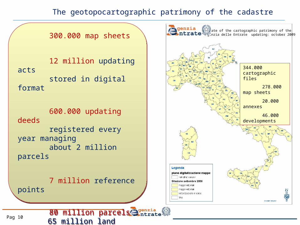
The geotopocartographic patrimony of the cadastre
344.000 cartographic files 278.000 map sheets
20.000 annexes
46.000 developments
State of the cartographic patrimony of the Agenzia delle Entrate updating: october 2009 300.000 map sheets
12 million updating acts stored in digital format
600.000 updating deeds registered every year managing about 2 million parcels
7 million reference points
80 million parcels65 million land parcels15 million building
parcels
26 million land owners
300.000 map sheets
12 million updating acts stored in digital format
600.000 updating deeds registered every year managing about 2 million parcels
7 million reference points
80 million parcels65 million land parcels15 million building
parcels
26 million land owners

Pag 11
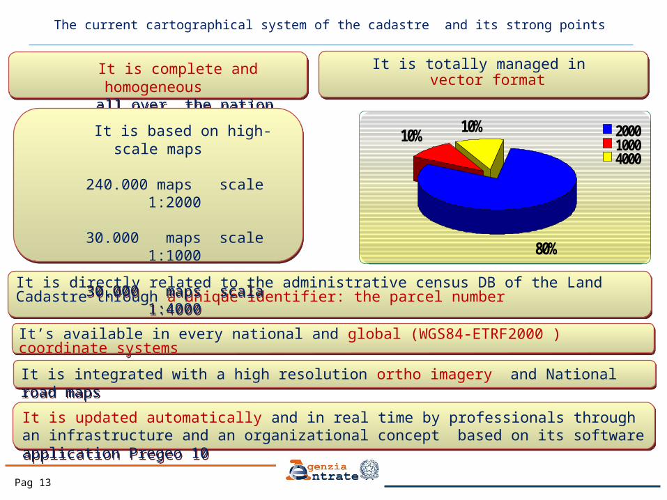
The current cartographical system of the cadastre and its strong points
It is integrated with a high resolution ortho imagery and National road maps It is integrated with a high resolution ortho imagery and National road maps
It is directly related to the administrative census DB of the Land Cadastre through a unique identifier: the parcel numberIt is directly related to the administrative census DB of the Land Cadastre through a unique identifier: the parcel number
It is totally managed in vector format
It is totally managed in vector format
It is complete and homogeneous all over the nation
It is complete and homogeneous all over the nation
It’s available in every national and global (WGS84-ETRF2000) coordinate systemsIt’s available in every national and global (WGS84-ETRF2000) coordinate systems
80%
10%10% 2000
10004000
It is based on high-scale maps
240.000 maps scale 1:2000
30.000 maps scale 1:1000
30.000 maps scala 1:4000
It is based on high-scale maps
240.000 maps scale 1:2000
30.000 maps scale 1:1000
30.000 maps scala 1:4000

Pag 12
S.I.T. - Integrated Territory System
Pag 13
The current cartographical system of the cadastre and its strong points
It is updated automatically and in real time by professionals through an infrastructure and an organizational concept based on its software application Pregeo 10It is updated automatically and in real time by professionals through an infrastructure and an organizational concept based on its software application Pregeo 10
It is integrated with a high resolution ortho imagery and National road maps It is integrated with a high resolution ortho imagery and National road maps
It is directly related to the administrative census DB of the Land Cadastre through a unique identifier: the parcel numberIt is directly related to the administrative census DB of the Land Cadastre through a unique identifier: the parcel number
It is totally managed in vector format
It is totally managed in vector format
It is complete and homogeneous all over the nation
It is complete and homogeneous all over the nation
It’s available in every national and global (WGS84-ETRF2000 ) coordinate systemsIt’s available in every national and global (WGS84-ETRF2000 ) coordinate systems
80%
10%10% 2000
10004000
It is based on high-scale maps
240.000 maps scale 1:2000
30.000 maps scale 1:1000
30.000 maps scala 1:4000
It is based on high-scale maps
240.000 maps scale 1:2000
30.000 maps scale 1:1000
30.000 maps scala 1:4000

Pag 14
Evolution of the updating process with PREGEO software application
1988 2006 20102003
PREGEO 8 PREGEO 9 PREGEO 10
Circular n° 2/’88
Software applications for the cadastre
updating
PREGEO
Updating acts web trasmission
SISTER
Cartography digital
management
WEGIS
Use of satellite technology
GNSS
Automatic updating
The new updating system
Pregeo_10
Pag 15
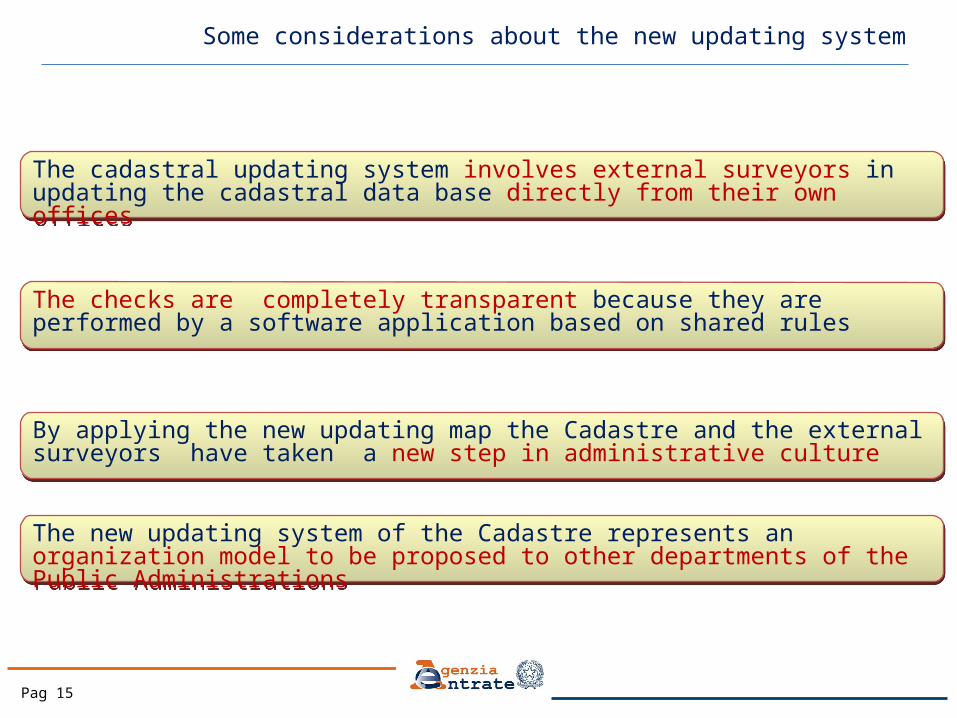
The checks are completely transparent because they are performed by a software application based on shared rules The checks are completely transparent because they are performed by a software application based on shared rules
The new updating system of the Cadastre represents an organization model to be proposed to other departments of the Public AdministrationsThe new updating system of the Cadastre represents an organization model to be proposed to other departments of the Public Administrations
By applying the new updating map the Cadastre and the external surveyors have taken a new step in administrative cultureBy applying the new updating map the Cadastre and the external surveyors have taken a new step in administrative culture
The cadastral updating system involves external surveyors in updating the cadastral data base directly from their own officesThe cadastral updating system involves external surveyors in updating the cadastral data base directly from their own offices
Some considerations about the new updating system

Pag 16
Number of Surveys by GNSS
The Cadastre updating by GNSS technology (Global Navigation Satellite System)
Number Of Surveys
Number of Surveys by GNSS
Updating System
Monitoring

Pag 17
Table of contents
• Overview on the cadastral cartography historic evolution
• The current cadastre cartographic system with a focus on the automatic system updating
• The Interoperability of the cadastral cartography: The trasformation of cadastral cartography
in the national and global coordinate systems
• The INSPIRE Directive implementation
• The cadastre cartographic system for land management

Pag 18
Unification of the National Coordinate Systems (Roma1940 Gauss-Boaga)
More than 800 differentCoordinate Systems
Cassini-SoldnerProjection System
Unification of the National Coordinate Systems
Roma1940
Pag 19
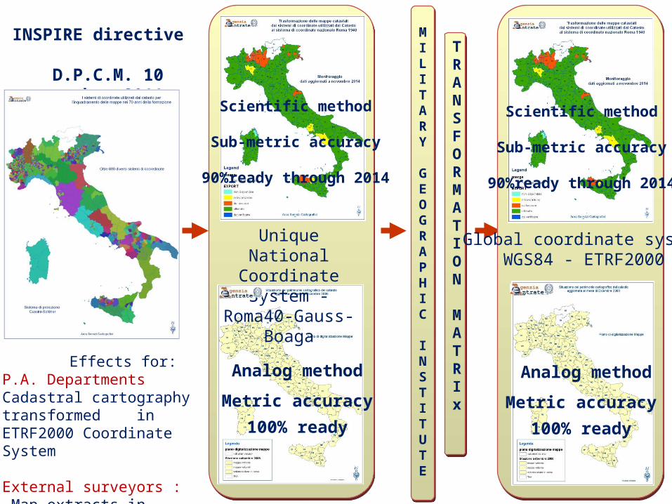
INSPIRE directive
D.P.C.M. 10 november 2011
MILITARY
GEOGRAPHIC
INSTITUTE
MILITARY
GEOGRAPHIC
INSTITUTE
TRANSFORMATION
MATRIx
TRANSFORMATION
MATRIx
Effects for:P.A. DepartmentsCadastral cartography transformed in ETRF2000 Coordinate System
External surveyors : Map extracts in ETRF2000
Analog method
Metric accuracy
100% ready
Unique National Coordinate System -
Roma40-Gauss-Boaga
Scientific method
Sub-metric accuracy
90%ready through 2014
Global coordinate systemWGS84 - ETRF2000
Analog method
Metric accuracy
100% ready
Scientific method
Sub-metric accuracy
90%ready through 2014

Pag 20
Table of contents
• Overview on the cadastral cartography historic evolution
• The current cadastre cartographic system with a focus on the automatic system updating
• The Interoperability of the cadastral cartography: The trasformation of cadastral cartography
in the national and global coordinate systems
• The INSPIRE Directive implementation
• The cadastre cartographic system for land management
Pag 21
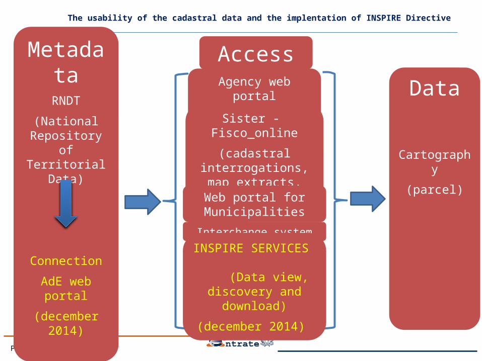
Access
MetadataRNDT
(National Repository of
Territorial Data)
Connection
AdE web portal
(december 2014)
Data
Cartography
(parcel)
The usability of the cadastral data and the implentation of INSPIRE Directive
Agency web portal
(PF-monographs)
Sister - Fisco_online
(cadastral interrogations, map extracts, vector maps)
Web portal for Municipalities
Interchange system
INSPIRE SERVICES (Data view, discovery
and download)
(december 2014)
Pag 22
Table of contents
• Overview on the cadastral cartography historic evolution
• The current cadastre cartographic system with a focus on the automatic system updating
• The Interoperability of the cadastral cartography: The trasformation of cadastral cartography
in the national and global coordinate systems
• The INSPIRE Directive implementation
• The cadastre cartographic system for land management

Pag 23 23Automatic identification of buildings not present on the cadastral map
Automatic identification of buildings not present on the cadastral map
The cadastre for the fight against tax evasion
Elevation Surface Model (ESM)Elevation Surface Model (ESM)
Classification of buildings (red) and vegetation (green) with infrared images
Classification of buildings (red) and vegetation (green) with infrared images
Classification of objects aboveground based on height Classification of objects aboveground based on height
Integration of the cadastral cartography with DEM, ESM, Infrared Images, and ortho imagery, for the automatic identification of buildings not declared to the cadastre
Integration of the cadastral cartography with DEM, ESM, Infrared Images, and ortho imagery, for the automatic identification of buildings not declared to the cadastre
From 2007 to 2010more than 2.000.000 buildings not declared to the Italian cadastre have been automatically Identified
From 2007 to 2010more than 2.000.000 buildings not declared to the Italian cadastre have been automatically Identified
The Law 78/2010, Gives to the Agenzia delle Entrate the periodic monitoring of national territory for detecting other
buildings not registered in cadastre
The Law 78/2010, Gives to the Agenzia delle Entrate the periodic monitoring of national territory for detecting other
buildings not registered in cadastre
Detection of Buildings not registered in cadastre

Pag 24
Aerial imagery acquisition by oblique camera system
Aerial Imagery

Pag 25
Integration of the cadastral Map with orthoimagery and oblique images for the survey of the exterior
features of buildings to support the Cadastre Review
Fg.495Paticella 234
Pag 26
Agenzia delle Entrate – Largo Leopardi, 5 00185 – Roma
The real estate information system managed by Agenzia delle Entrate
The evolution of cartographic system
for the land management
Roma, November 20th 2014
Eng. Flavio FerranteCentral Directorate Cadastre and
CartographyItalian Revenue Agency
Thanks for Your attention