package 'gstat
TRANSCRIPT

Package ‘gstat’March 12, 2017
Version 1.1-5
Title Spatial and Spatio-Temporal Geostatistical Modelling, Predictionand Simulation
Description Variogram modelling; simple, ordinary and universal point or block (co)kriging; spatio-temporal kriging; sequential Gaussian or indicator (co)simulation; variogram and vari-ogram map plotting utility functions.
Depends R (>= 2.10)
Imports utils, stats, graphics, methods, lattice, sp (>= 0.9-72), zoo,spacetime (>= 1.0-0), FNN
Suggests rgdal (>= 0.5.2), rgeos, fields, maps, mapdata, maptools, xts
License GPL (>= 2.0)
URL https://github.com/edzer/gstat/
Encoding UTF-8
BugReports https://github.com/edzer/gstat/issues/
NeedsCompilation yes
Author Edzer Pebesma [aut, cre],Benedikt Graeler [aut]
Maintainer Edzer Pebesma <[email protected]>
Repository CRAN
Date/Publication 2017-03-12 09:02:30
R topics documented:coalash . . . . . . . . . . . . . . . . . . . . . . . . . . . . . . . . . . . . . . . . . . . 3DE_RB_2005 . . . . . . . . . . . . . . . . . . . . . . . . . . . . . . . . . . . . . . . . 4estiStAni . . . . . . . . . . . . . . . . . . . . . . . . . . . . . . . . . . . . . . . . . . 5extractPar . . . . . . . . . . . . . . . . . . . . . . . . . . . . . . . . . . . . . . . . . . 6fit.lmc . . . . . . . . . . . . . . . . . . . . . . . . . . . . . . . . . . . . . . . . . . . . 7fit.StVariogram . . . . . . . . . . . . . . . . . . . . . . . . . . . . . . . . . . . . . . . 8fit.variogram . . . . . . . . . . . . . . . . . . . . . . . . . . . . . . . . . . . . . . . . . 11
1

2 R topics documented:
fit.variogram.gls . . . . . . . . . . . . . . . . . . . . . . . . . . . . . . . . . . . . . . . 13fit.variogram.reml . . . . . . . . . . . . . . . . . . . . . . . . . . . . . . . . . . . . . . 14fulmar . . . . . . . . . . . . . . . . . . . . . . . . . . . . . . . . . . . . . . . . . . . . 15get.contr . . . . . . . . . . . . . . . . . . . . . . . . . . . . . . . . . . . . . . . . . . . 16gstat . . . . . . . . . . . . . . . . . . . . . . . . . . . . . . . . . . . . . . . . . . . . . 17hscat . . . . . . . . . . . . . . . . . . . . . . . . . . . . . . . . . . . . . . . . . . . . . 21image . . . . . . . . . . . . . . . . . . . . . . . . . . . . . . . . . . . . . . . . . . . . 22jura . . . . . . . . . . . . . . . . . . . . . . . . . . . . . . . . . . . . . . . . . . . . . 24krige . . . . . . . . . . . . . . . . . . . . . . . . . . . . . . . . . . . . . . . . . . . . . 26krige.cv . . . . . . . . . . . . . . . . . . . . . . . . . . . . . . . . . . . . . . . . . . . 30krigeST . . . . . . . . . . . . . . . . . . . . . . . . . . . . . . . . . . . . . . . . . . . 33krigeTg . . . . . . . . . . . . . . . . . . . . . . . . . . . . . . . . . . . . . . . . . . . 35map.to.lev . . . . . . . . . . . . . . . . . . . . . . . . . . . . . . . . . . . . . . . . . . 37meuse.all . . . . . . . . . . . . . . . . . . . . . . . . . . . . . . . . . . . . . . . . . . 38meuse.alt . . . . . . . . . . . . . . . . . . . . . . . . . . . . . . . . . . . . . . . . . . 40ncp.grid . . . . . . . . . . . . . . . . . . . . . . . . . . . . . . . . . . . . . . . . . . . 40ossfim . . . . . . . . . . . . . . . . . . . . . . . . . . . . . . . . . . . . . . . . . . . . 41oxford . . . . . . . . . . . . . . . . . . . . . . . . . . . . . . . . . . . . . . . . . . . . 43pcb . . . . . . . . . . . . . . . . . . . . . . . . . . . . . . . . . . . . . . . . . . . . . . 44plot.gstatVariogram . . . . . . . . . . . . . . . . . . . . . . . . . . . . . . . . . . . . . 46plot.pointPairs . . . . . . . . . . . . . . . . . . . . . . . . . . . . . . . . . . . . . . . . 48plot.variogramCloud . . . . . . . . . . . . . . . . . . . . . . . . . . . . . . . . . . . . 50predict . . . . . . . . . . . . . . . . . . . . . . . . . . . . . . . . . . . . . . . . . . . . 51progress . . . . . . . . . . . . . . . . . . . . . . . . . . . . . . . . . . . . . . . . . . . 55show.vgms . . . . . . . . . . . . . . . . . . . . . . . . . . . . . . . . . . . . . . . . . . 56sic2004 . . . . . . . . . . . . . . . . . . . . . . . . . . . . . . . . . . . . . . . . . . . 57sic97 . . . . . . . . . . . . . . . . . . . . . . . . . . . . . . . . . . . . . . . . . . . . . 59spplot.vcov . . . . . . . . . . . . . . . . . . . . . . . . . . . . . . . . . . . . . . . . . 60tull . . . . . . . . . . . . . . . . . . . . . . . . . . . . . . . . . . . . . . . . . . . . . . 61variogram . . . . . . . . . . . . . . . . . . . . . . . . . . . . . . . . . . . . . . . . . . 63variogramLine . . . . . . . . . . . . . . . . . . . . . . . . . . . . . . . . . . . . . . . . 67variogramST . . . . . . . . . . . . . . . . . . . . . . . . . . . . . . . . . . . . . . . . 68variogramSurface . . . . . . . . . . . . . . . . . . . . . . . . . . . . . . . . . . . . . . 70vgm . . . . . . . . . . . . . . . . . . . . . . . . . . . . . . . . . . . . . . . . . . . . . 71vgm.panel.xyplot . . . . . . . . . . . . . . . . . . . . . . . . . . . . . . . . . . . . . . 74vgmArea . . . . . . . . . . . . . . . . . . . . . . . . . . . . . . . . . . . . . . . . . . 75vgmST . . . . . . . . . . . . . . . . . . . . . . . . . . . . . . . . . . . . . . . . . . . . 76vv . . . . . . . . . . . . . . . . . . . . . . . . . . . . . . . . . . . . . . . . . . . . . . 78walker . . . . . . . . . . . . . . . . . . . . . . . . . . . . . . . . . . . . . . . . . . . . 79wind . . . . . . . . . . . . . . . . . . . . . . . . . . . . . . . . . . . . . . . . . . . . . 80
Index 83

coalash 3
coalash Coal ash samples from a mine in Pennsylvania
Description
Data obtained from Gomez and Hazen (1970, Tables 19 and 20) on coal ash for the Robena MineProperty in Greene County Pennsylvania.
Usage
data(coalash)
Format
This data frame contains the following columns:
x a numeric vector; x-coordinate; reference unknown
y a numeric vector; x-coordinate; reference unknown
coalash the target variable
Note
data are also present in package fields, as coalash.
Author(s)
unknown; R version prepared by Edzer Pebesma; data obtained from http://www.stat.uiowa.edu/~dzimmer/spatialstats/, Dale Zimmerman’s course page
References
N.A.C. Cressie, 1993, Statistics for Spatial Data, Wiley.
Gomez, M. and Hazen, K. (1970). Evaluating sulfur and ash distribution in coal seems by statisticalresponse surface regression analysis. U.S. Bureau of Mines Report RI 7377.
see also fields manual: http://www.image.ucar.edu/GSP/Software/Fields/fields.manual.coalashEX.Krig.shtml
Examples
data(coalash)summary(coalash)

4 DE_RB_2005
DE_RB_2005 Spatio-temporal data set with rural background PM10 concentrationsin Germany 2005
Description
Spatio-temporal data set with rural background PM10 concentrations in Germany 2005 (airbasev6).
Usage
data("DE_RB_2005")
Format
The format is: Formal class ’STSDF’ [package "spacetime"] with 5 slots ..@ data :’data.frame’:23230 obs. of 2 variables: .. ..$ PM10 : num [1:23230] 16.7 31.7 5 22.4 26.8 ... .. ..$ logPM10:num [1:23230] 2.82 3.46 1.61 3.11 3.29 ... ..@ index : int [1:23230, 1:2] 1 2 3 4 5 6 7 8 9 10 ... ..@sp :Formal class ’SpatialPointsDataFrame’ [package "sp"] with 5 slots .. .. ..@ data :’data.frame’:69 obs. of 9 variables: .. .. .. ..$ station_altitude : int [1:69] 8 3 700 15 35 50 343 339 45 45... .. .. .. ..$ station_european_code: Factor w/ 7965 levels "AD0942A","AD0944A",..: 19911648 1367 2350 1113 1098 1437 2043 1741 1998 ... .. .. .. ..$ country_iso_code : Factor w/39 levels "AD","AL","AT",..: 10 10 10 10 10 10 10 10 10 10 ... .. .. .. ..$ station_start_date :Factor w/ 2409 levels "1900-01-01","1951-04-01",..: 152 1184 1577 1132 744 328 1202 1555 1148407 ... .. .. .. ..$ station_end_date : Factor w/ 864 levels "","1975-02-06",..: 1 1 1 579 1 1 1 11 1 ... .. .. .. ..$ type_of_station : Factor w/ 5 levels "","Background",..: 2 2 2 2 2 2 2 2 2 2 ..... .. .. ..$ station_type_of_area : Factor w/ 4 levels "rural","suburban",..: 1 1 1 1 1 1 1 1 1 1 ..... .. .. ..$ street_type : Factor w/ 5 levels "","Canyon street: L/H < 1.5",..: 4 1 1 1 1 1 1 1 1 1... .. .. .. ..$ annual_mean_PM10 : num [1:69] 20.9 21.8 16.5 20.3 23.3 ... .. .. ..@ coords.nrs: num(0) .. .. ..@ coords : num [1:69, 1:2] 538709 545414 665711 551796 815738 ... .. .. ....- attr(*, "dimnames")=List of 2 .. .. .. .. ..$ : chr [1:69] "DESH001" "DENI063" "DEBY109""DEUB038" ... .. .. .. .. ..$ : chr [1:2] "coords.x1" "coords.x2" .. .. ..@ bbox : num [1:2, 1:2]307809 5295752 907375 6086661 .. .. .. ..- attr(*, "dimnames")=List of 2 .. .. .. .. ..$ : chr[1:2] "coords.x1" "coords.x2" .. .. .. .. ..$ : chr [1:2] "min" "max" .. .. ..@ proj4string:Formal class’CRS’ [package "sp"] with 1 slot .. .. .. .. ..@ projargs: chr "+init=epsg:32632 +proj=utm +zone=32+datum=WGS84 +units=m +no_defs +ellps=WGS84 +towgs84=0,0,0" ..@ time :An ?xts? objecton 2005-01-01/2005-12-31 containing: Data: int [1:365, 1] 5115 5116 5117 5118 5119 5120 51215122 5123 5124 ... - attr(*, "dimnames")=List of 2 ..$ : NULL ..$ : chr "..1" Indexed by objects ofclass: [POSIXct,POSIXt] TZ: GMT xts Attributes: NULL ..@ endTime: POSIXct[1:365], format:"2005-01-02" "2005-01-03" "2005-01-04" "2005-01-05" ...
Source
EEA, airbase v6

estiStAni 5
Examples
data(DE_RB_2005)str(DE_RB_2005)
estiStAni Estimation of the spatio-temporal anisotropy
Description
Estimation of the spatio-temporal anisotropy without an underlying spatio-temporal model. Differ-ent methods are implemented using a linear model to predict the temporal gamma values or the ratioof the ranges of a spatial and temporal variogram model or a spatial variogram model to predict thetemporal gamma values or the spatio-temporal anisotropy value as used in a metric spatio-temporalvariogram.
Usage
estiStAni(empVgm, interval, method = "linear", spatialVgm,temporalVgm, s.range=NA, t.range=NA)
Arguments
empVgm An empirical spatio-temporal variogram.
interval A search interval for the optimisation of the spatio-temporal anisotropy param-eter
method A character string determining the method to be used (one of linear, range,vgm or metric, see below for details)
spatialVgm A spatial variogram definition from the call to vgm. The model is optimisedbased on the pure spatial values in empVgm.
temporalVgm A temporal variogram definition from the call to vgm. The model is optimisedbased on the pure temporal values in empVgm.
s.range A spatial cutoff value applied to the empirical variogram empVgm.
t.range A temporal cutoff value applied to the empirical variogram empVgm.
Details
linear A linear model is fitted to the pure spatial gamma values based on the spatial distances.An optimal scaling is searched to stretch the temporal distances such that the linear modelexplains best the pure temporal gamma values. This assumes (on average) a linear relationshipbetween distance and gamma, hence it is advisable to use only those pairs of pure spatial (puretemporal) distance and gamma value that show a considerable increase (i.e. drop all valuesbeyond the range by setting values for s.range and t.range).
range A spatial and temporal variogram model is fitted to the pure spatial and temporal gammavalues respectively. The spatio-temporal anisotropy estimate is the ratio of the spatial rangeover the temporal range.

6 extractPar
vgm A spatial variogram model is fitted to the pure spatial gamma values. An optimal scaling isused to stretch the temporal distances such that the spatial variogram model explains best thepure temporal gamma values.
metric A metric spatio-temporal variogram model is fitted with joint component according tothe defined spatial variogram spatialVgm. The starting value of stAni is the mean of theinterval parameter (see vgmST for the metric variogram definition). The spatio-temporalanisotropy as estimated in the spatio-temporal variogram is returned. Note that the parameterinterval is only used to set the starting value. Hence, the estimate might exceed the giveninterval.
Value
A scalar representing the spatio-temporal anisotropy estimate.
Note
Different methods might lead to very different estimates. All but the linear approach are sensitiveto the variogram model selection.
Author(s)
Benedikt Graeler
Examples
data(vv)
estiStAni(vv, c(10, 150))estiStAni(vv, c(10, 150), "vgm", vgm(80, "Sph", 120, 20))
extractPar Extracting parameters and their names from a spatio-temporal vari-ogram model
Description
All spatio-temporal variogram models have a different set of parameters. These functions extractthe parameters and their names from the spatio-temporal variogram model. Note, this function is aswell used to pass the parameters to the optim function. The arguments lower and upper passed tooptim should follow the same structure.
Usage
extractPar(model)extractParNames(model)
Arguments
model a spatio-temporal variogram model from vgmST

fit.lmc 7
Value
A named numeric vector of parameters or a vector of characters holding the parameters’ names.
Author(s)
Benedikt Graeler
See Also
fit.StVariogram and vgmST
Examples
sumMetricModel <- vgmST("sumMetric",space=vgm(30, "Sph", 200, 6),time =vgm(30, "Sph", 15, 7),joint=vgm(60, "Exp", 84, 22),stAni=100)
extractPar(sumMetricModel)extractParNames(sumMetricModel)
fit.lmc Fit a Linear Model of Coregionalization to a Multivariable SampleVariogram
Description
Fit a Linear Model of Coregionalization to a Multivariable Sample Variogram; in case of a singlevariogram model (i.e., no nugget) this is equivalent to Intrinsic Correlation
Usage
fit.lmc(v, g, model, fit.ranges = FALSE, fit.lmc = !fit.ranges,correct.diagonal = 1.0, ...)
Arguments
v multivariable sample variogram, output of variogram
g gstat object, output of gstat
model variogram model, output of vgm; if supplied this value is used as initial valuefor each fit
fit.ranges logical; determines whether the range coefficients (excluding that of the nuggetcomponent) should be fitted; or logical vector: determines for each range pa-rameter of the variogram model whether it should be fitted or fixed.
fit.lmc logical; if TRUE, each coefficient matrices of partial sills is guaranteed to bepositive definite

8 fit.StVariogram
correct.diagonal
multiplicative correction factor to be applied to partial sills of direct variogramsonly; the default value, 1.0, does not correct. If you encounter problems withsingular covariance matrices during cokriging or cosimulation, you may want totry to increase this to e.g. 1.01
... parameters that get passed to fit.variogram
Value
returns an object of class gstat, with fitted variograms;
Note
This function does not use the iterative procedure proposed by M. Goulard and M. Voltz (Math.Geol., 24(3): 269-286; reproduced in Goovaerts’ 1997 book) but uses simply two steps: first, eachvariogram model is fitted to a direct or cross variogram; next each of the partial sill coefficientmatrices is approached by its in least squares sense closest positive definite matrices (by setting anynegative eigenvalues to zero).
The argument correct.diagonal was introduced by experience: by zeroing the negative eigenval-ues for fitting positive definite partial sill matrices, apparently still perfect correlation may result,leading to singular cokriging/cosimulation matrices. If someone knows of a more elegant way toget around this, please let me know.
Author(s)
Edzer Pebesma
References
http://www.gstat.org/
See Also
variogram, vgm, fit.variogram, demo(cokriging)
fit.StVariogram Fit a spatio-temporal sample variogram to a sample variogram
Description
Fits a spatio-temporal variogram of a given type to spatio-temporal sample variogram.
Usage
fit.StVariogram(object, model, ..., method = "L-BFGS-B",lower, upper, fit.method = 6, stAni=NA, wles)

fit.StVariogram 9
Arguments
object The spatio-temporal sample variogram. Typically output from variogramST
model The desired spatio-temporal model defined through vgmST.
... further arguments passed to optim. extractParNames provides the parame-ter structure of spatio-temporal variogram models that help to provide sensibleupper and lower limits.
lower Lower limits used by optim. If missing, the smallest well defined values areused (mostly near 0).
upper Upper limits used by optim. If missing, the largest well defined values are used(mostly Inf).
method fit method, pass to optim
fit.method an integer between 0 and 13 determine the fitting routine (i.e. weighting of thesquared residuals in the LSE). Values 0 to 6 correspond with the pure spatialversion (see fit.variogram). See the details section for the meaning of theother values (partly experimental).
stAni The spatio-temporal anisotropy that is used in the weighting. Might be missingif the desired spatio-temporal variogram model does contain a spatio-temporalanisotropy parameter (this might cause bad convergence behaviour). The defaultis NA and will be understood as identity (1 temporal unit = 1 spatial unit). Asthis only in very few cases a valid assumption, a warning is issued.
wles Should be missing; only for backwards compatibility, wles = TRUE correspondsto fit.method = 1 and wles = FALSE corresponds to fit.method = 6.
Details
The following list summarizes the meaning of the fit.method argument which is essential aweighting of the squared residuals in the least-squares estimation. Please note, that weights basedon the models gamma value might fail to converge properly due to the dependence of weights onthe variogram estimate:
fit.method = 0 no fitting, however the MSE between the provided variogram model and samplevariogram surface is calculated.
fit.method = 1 Number of pairs in the spatio-temporal bin: Nj
fit.method = 2 Number of pairs in the spatio-temporal bin divided by the square of the currentvariogram model’s value: Nj/γ(hj , uj)
2
fit.method = 3 Same as fit.method = 1 for compatibility with fit.variogram but as wellevaluated in R.
fit.method = 4 Same as fit.method = 2 for compatibility with fit.variogram but as wellevaluated in R.
fit.method = 5 Reserved for REML for compatibility with fit.variogram, not yet implemented.
fit.method = 6 No weights.
fit.method = 7 Number of pairs in the spatio-temporal bin divided by the square of the bin’smetric distance. If stAni is not specified, the model’s parameter is used to calculate themetric distance across space and time: Nj/(h
2j + stAni2 · u2j )

10 fit.StVariogram
fit.method = 8 Number of pairs in the spatio-temporal bin divided by the square of the bin’sspatial distance. Nj/h
2j . Note that the 0 distances are replaced by the smallest non-zero
distances to avoid division by zero.
fit.method = 9 Number of pairs in the spatio-temporal bin divided by the square of the bin’stemporal distance. Nj/u
2j . Note that the 0 distances are replaced by the smallest non-zero
distances to avoid division by zero.
fit.method = 10 Reciprocal of the square of the current variogram model’s value: 1/γ(hj , uj)2
fit.method = 11 Reciprocal of the square of the bin’s metric distance. If stAni is not specified,the model’s parameter is used to calculate the metric distance across space and time: 1/(h2j +stAni2 · u2j )
fit.method = 12 Reciprocal of the square of the bin’s spatial distance. 1/h2j . Note that the 0distances are replaced by the smallest non-zero distances to avoid division by zero.
fit.method = 13 Reciprocal of the square of the bin’s temporal distance. 1/u2j . Note that the 0distances are replaced by the smallest non-zero distances to avoid division by zero.
See also Table 4.2 in the gstat manual for the original spatial version.
Value
Returns a spatio-temporal variogram model, as S3 class StVariogramModel. It carries the temporaland spatial unit as attributes "temporal unit" and "spatial unit" in order to allow krigeST toadjust for different units. The units are obtained from the provided empirical variogram. Furtherattributes are the optim output "optim.output" and the always not weighted mean squared error"MSE".
Author(s)
Benedikt Graeler
See Also
fit.variogram for the pure spatial case. extractParNames helps to understand the parameterstructure of spatio-temporal variogram models.
Examples
# separable model: spatial and temporal sill will be ignored# and kept constant at 1-nugget respectively. A joint sill is used.## Not run:separableModel <- vgmST("separable",
method = "Nelder-Mead", # no lower & upper neededspace=vgm(0.9,"Exp", 123, 0.1),time =vgm(0.9,"Exp", 2.9, 0.1),sill=100)
data(vv)separableModel <- fit.StVariogram(vv, separableModel,
method="L-BFGS-B",lower=c(10,0,0.01,0,1),

fit.variogram 11
upper=c(500,1,20,1,200))plot(vv, separableModel)
## End(Not run) # dontrun
fit.variogram Fit a Variogram Model to a Sample Variogram
Description
Fit ranges and/or sills from a simple or nested variogram model to a sample variogram
Usage
fit.variogram(object, model, fit.sills = TRUE, fit.ranges = TRUE,fit.method = 7, debug.level = 1, warn.if.neg = FALSE, fit.kappa = FALSE)
Arguments
object sample variogram, output of variogram
model variogram model, output of vgm; see Details below for details on how NA valuesin model are initialised.
fit.sills logical; determines whether the partial sill coefficients (including nugget vari-ance) should be fitted; or logical vector: determines for each partial sill param-eter whether it should be fitted or fixed.
fit.ranges logical; determines whether the range coefficients (excluding that of the nuggetcomponent) should be fitted; or logical vector: determines for each range pa-rameter whether it should be fitted or fixed.
fit.method fitting method, used by gstat. The default method uses weights $N_h/h^2$ with$N_h$ the number of point pairs and $h$ the distance. This criterion is not sup-ported by theory, but by practice. For other values of fit.method, see details.
debug.level integer; set gstat internal debug level
warn.if.neg logical; if TRUE a warning is issued whenever a sill value of a direct variogrambecomes negative
fit.kappa logical; if TRUE, a sequence of 0.3, 0.4,...,5 will be searched for optimal fit;alternatively another sequence can be given to this argument
Details
If any of the initial parameters of model are NA, they are given default values as follows. The rangeparameter is given one third of the maximum value of object$dist. The nugget value is given themean value of the first three values of object$gamma. The partial sill is given the mean of the lastfive values of object$gamma.
Values for fit.method are 1: weights equal to $N_j$; 2: weights equal to $N_j/((gamma(h_j))^2)$;5 (ignore, use fit.variogram.reml); 6: unweighted (OLS); 7: $N_j/(h_j^2)$. (from: http://www.gstat.org/gstat.pdf, table 4.2).

12 fit.variogram
Value
returns a fitted variogram model (of class variogramModel).
This is a data.frame with two attributes: (i) singular a logical attribute that indicates whetherthe non-linear fit converged (FALSE), or ended in a singularity (TRUE), and (ii) SSErr a numericalattribute with the (weighted) sum of squared errors of the fitted model. See Notes below.
Note
If fitting the range(s) is part of the job of this function, the results may well depend on the startingvalues, given in argument model, which is generally the case for non-linear regression problems.This function uses internal C code, which uses Levenberg-Marquardt.
If for a direct (i.e. not a cross) variogram a sill parameter (partial sill or nugget) becomes negative,fit.variogram is called again with this parameter set to zero, and with a FALSE flag to further fit thissill. This implies that the search does not move away from search space boundaries.
On singular model fits: If your variogram turns out to be a flat, horizontal or sloping line, then fittinga three parameter model such as the exponential or spherical with nugget is a bit heavy: there’s aninfinite number of possible combinations of sill and range (both very large) to fit to a sloping line. Inthis case, the returned, singular model may still be useful: just try and plot it. Gstat converges whenthe parameter values stabilize, and this may not be the case. Another case of singular model fitshappens when a model that reaches the sill (such as the spherical) is fit with a nugget, and the rangeparameter starts, or converges to a value smaller than the distance of the second sample variogramestimate. In this case, again, an infinite number of possibilities occur essentially for fitting a linethrough a single (first sample variogram) point. In both cases, fixing one or more of the variogrammodel parameters may help you out.
Author(s)
Edzer Pebesma
References
http://www.gstat.org/
Pebesma, E.J., 2004. Multivariable geostatistics in S: the gstat package. Computers \& Geo-sciences, 30: 683-691.
See Also
variogram, vgm
Examples
library(sp)data(meuse)coordinates(meuse) = ~x+yvgm1 <- variogram(log(zinc)~1, meuse)fit.variogram(vgm1, vgm(1, "Sph", 300, 1))fit.variogram(vgm1, vgm("Sph"))

fit.variogram.gls 13
# optimize the value of kappa in a Matern model, using ugly <<- side effect:f = function(x) attr(m.fit <<- fit.variogram(vgm1, vgm(,"Mat",nugget=NA,kappa=x)),"SSErr")optimize(f, c(0.1, 5))plot(vgm1, m.fit)# best fit from the (0.3, 0.4, 0.5. ... , 5) sequence:(m <- fit.variogram(vgm1, vgm("Mat"), fit.kappa = TRUE))attr(m, "SSErr")
fit.variogram.gls GLS fitting of variogram parameters
Description
Fits variogram parameters (nugget, sill, range) to variogram cloud, using GLS (generalized leastsquares) fitting. Only for direct variograms.
Usage
fit.variogram.gls(formula, data, model, maxiter = 30,eps = .01, trace = TRUE, ignoreInitial = TRUE, cutoff = Inf,plot = FALSE)
Arguments
formula formula defining the response vector and (possible) regressors; in case of ab-sence of regressors, use e.g. z~1
data object of class Spatialmodel variogram model to be fitted, output of vgmmaxiter maximum number of iterationseps convergence criteriumtrace logical; if TRUE, prints parameter traceignoreInitial logical; if FALSE, initial parameter are taken from model; if TRUE, initial val-
ues of model are ignored and taken from variogram cloud: nugget: mean(y)/2,sill: mean(y)/2, range median(h0)/4 with y the semivariance cloud value andh0 the distances
cutoff maximum distance up to which point pairs are taken into considerationplot logical; if TRUE, a plot is returned with variogram cloud and fitted model; else,
the fitted model is returned.
Value
an object of class "variogramModel"; see fit.variogram; if plot is TRUE, a plot is returned instead.
Note
Inspired by the code of Mihael Drinovac, which was again inspired by code from Ernst Glatzer,author of package vardiag.

14 fit.variogram.reml
Author(s)
Edzer Pebesma
References
Mueller, W.G., 1999: Least-squares fitting from the variogram cloud. Statistics \& ProbabilityLetters, 43, 93-98.
Mueller, W.G., 2007: Collecting Spatial Data. Springer, Heidelberg.
See Also
fit.variogram,
Examples
library(sp)data(meuse)coordinates(meuse) = ~x+y## Not run:fit.variogram.gls(log(zinc)~1, meuse[1:40,], vgm(1, "Sph", 900,1))
## End(Not run)
fit.variogram.reml REML Fit Direct Variogram Partial Sills to Data
Description
Fit Variogram Sills to Data, using REML (only for direct variograms; not for cross variograms)
Usage
fit.variogram.reml(formula, locations, data, model, debug.level = 1, set, degree = 0)
Arguments
formula formula defining the response vector and (possible) regressors; in case of ab-sence of regressors, use e.g. z~1
locations spatial data locations; a formula with the coordinate variables in the right hand(dependent variable) side.
data data frame where the names in formula and locations are to be found
model variogram model to be fitted, output of vgm
debug.level debug level; set to 65 to see the iteration trace and log likelihood
set additional options that can be set; use set=list(iter=100) to set the max.number of iterations to 100.
degree order of trend surface in the location, between 0 and 3

fulmar 15
Value
an object of class "variogramModel"; see fit.variogram
Note
This implementation only uses REML fitting of sill parameters. For each iteration, an n× n matrixis inverted, with $n$ the number of observations, so for large data sets this method becomes de-manding. I guess there is much more to likelihood variogram fitting in package geoR, and probablyalso in nlme.
Author(s)
Edzer Pebesma
References
Christensen, R. Linear models for multivariate, Time Series, and Spatial Data, Springer, NY, 1991.
Kitanidis, P., Minimum-Variance Quadratic Estimation of Covariances of Regionalized Variables,Mathematical Geology 17 (2), 195–208, 1985
See Also
fit.variogram,
Examples
library(sp)data(meuse)fit.variogram.reml(log(zinc)~1, ~x+y, meuse, model = vgm(1, "Sph", 900,1))
fulmar Fulmaris glacialis data
Description
Airborne counts of Fulmaris glacialis during the Aug/Sept 1998 and 1999 flights on the Dutch(Netherlands) part of the North Sea (NCP, Nederlands Continentaal Plat).
Usage
data(fulmar)

16 get.contr
Format
This data frame contains the following columns:
year year of measurement: 1998 or 1999x x-coordinate in UTM zone 31y y-coordinate in UTM zone 31depth sea water depth, in mcoast distance to coast of the Netherlands, in km.fulmar observed density (number of birds per square km)
Author(s)
Dutch National Institute for Coastal and Marine Management (RIKZ), http://www.rikz.nl/
See Also
ncp.grid
E.J. Pebesma, R.N.M. Duin, P.A. Burrough, 2005. Mapping Sea Bird Densities over the North Sea:Spatially Aggregated Estimates and Temporal Changes. Environmetrics 16, (6), p 573-587.
Examples
data(fulmar)summary(fulmar)## Not run:demo(fulmar)
## End(Not run)
get.contr Calculate contrasts from multivariable predictions
Description
Given multivariable predictions and prediction (co)variances, calculate contrasts and their (co)variance
Usage
get.contr(data, gstat.object, X, ids = names(gstat.object$data))
Arguments
data data frame, output of predictgstat.object object of class gstat, used to extract ids; may be missing if ids is usedX contrast vector or matrix; the number of variables in gstat.object should equal
the number of elements in X if X is a vector, or the number of rows in X if X is amatrix.
ids character vector with (selection of) id names, present in data

gstat 17
Details
From data, we can extract the n × 1 vector with multivariable predictions, say $y$, and its n × ncovariance matrix $V$. Given a contrast matrix in $X$, this function computes the contrast vector$C=X’y$ and its variance $Var(C)=X’V X$.
Value
a data frame containing for each row in data the generalized least squares estimates (named beta.1,beta.2, ...), their variances (named var.beta.1, var.beta.2, ...) and covariances (named cov.beta.1.2,cov.beta.1.3, ...)
Author(s)
Edzer Pebesma
References
http://www.gstat.org/
See Also
predict
gstat Create gstat objects, or subset it
Description
Function that creates gstat objects; objects that hold all the information necessary for univariate ormultivariate geostatistical prediction (simple, ordinary or universal (co)kriging), or its conditionalor unconditional Gaussian or indicator simulation equivalents. Multivariate gstat object can besubsetted.
Usage
gstat(g, id, formula, locations, data, model = NULL, beta,nmax = Inf, nmin = 0, omax = 0, maxdist = Inf, force = FALSE,dummy = FALSE, set, fill.all = FALSE,fill.cross = TRUE, variance = "identity", weights = NULL, merge,degree = 0, vdist = FALSE, lambda = 1.0)## S3 method for class 'gstat'print(x, ...)

18 gstat
Arguments
g gstat object to append to; if missing, a new gstat object is created
id identifier of new variable; if missing, varn is used with n the number for thisvariable. If a cross variogram is entered, id should be a vector with the two idvalues , e.g. c("zn", "cd"), further only supplying arguments g and model.It is advisable not to use expressions, such as log(zinc), as identifiers, as thismay lead to complications later on.
formula formula that defines the dependent variable as a linear model of independentvariables; suppose the dependent variable has name z, for ordinary and simplekriging use the formula z~1; for simple kriging also define beta (see below); foruniversal kriging, suppose z is linearly dependent on x and y, use the formulaz~x+y
locations formula with only independent variables that define the spatial data locations(coordinates), e.g. ~x+y; if data has a coordinates method to extract its co-ordinates this argument can be ignored (see package sp for classes for point orgrid data).
data data frame; contains the dependent variable, independent variables, and loca-tions.
model variogram model for this id; defined by a call to vgm; see argument id to seehow cross variograms are entered
beta for simple kriging (and simulation based on simple kriging): vector with thetrend coefficients (including intercept); if no independent variables are definedthe model only contains an intercept and this should be the expected value; forcross variogram computations: mean parameters to be used instead of the OLSestimates
nmax for local kriging: the number of nearest observations that should be used for akriging prediction or simulation, where nearest is defined in terms of the spaceof the spatial locations
nmin for local kriging: if the number of nearest observations within distance maxdistis less than nmin, a missing value will be generated, unless force==TRUE; seemaxdist
omax maximum number of observations to select per octant (3D) or quadrant (2D);only relevant if maxdist has been defined as well
maxdist for local kriging: only observations within a distance of maxdist from the pre-diction location are used for prediction or simulation; if combined with nmax,both criteria apply
force for local kriging, force neighbourhood selection: in case nmin is given, searchbeyond maxdist until nmin neighbours are found. A missing value is returnedif this is not possible.
dummy logical; if TRUE, consider this data as a dummy variable (only necessary forunconditional simulation)
set named list with optional parameters to be passed to gstat (only set commandsof gstat are allowed, and not all of them may be relevant; see the manual forgstat stand-alone, URL below )

gstat 19
x gstat object to print
fill.all logical; if TRUE, fill all of the direct variogram and, depending on the value offill.cross also all cross variogram model slots in g with the given variogrammodel
fill.cross logical; if TRUE, fill all of the cross variograms, if FALSE fill only all directvariogram model slots in g with the given variogram model (only if fill.allis used)
variance character; variance function to transform to non-stationary covariances; "iden-tity" does not transform, other options are "mu" (Poisson) and "mu(1-mu)" (bi-nomial)
weights numeric vector; if present, covariates are present, and variograms are missingweights are passed to OLS prediction routines resulting in WLS; if variogramsare given, weights should be 1/variance, where variance specifies location-specificmeasurement error; see references section below
merge either character vector of length 2, indicating two ids that share a common mean;the more general gstat merging of any two coefficients across variables is ob-tained when a list is passed, with each element a character vector of length 4, inthe form c("id1", 1,"id2", 2). This merges the first parameter for variableid1 to the second of variable id2.
degree order of trend surface in the location, between 0 and 3
vdist logical; if TRUE, instead of Euclidian distance variogram distance is used for se-lecting the nmax nearest neighbours, after observations within distance maxdist(Euclidian/geographic) have been pre-selected
lambda test feature; doesn’t do anything (yet)
... arguments that are passed to the printing of variogram models only
Details
to print the full contents of the object g returned, use as.list(g) or print.default(g)
Value
an object of class gstat, which inherits from list. Its components are:
data list; each element is a list with the formula, locations, data, nvars, beta,etc., for a variable
model list; each element contains a variogram model; names are those of the elementsof data; cross variograms have names of the pairs of data elements, separatedby a . (e.g.: var1.var2
)
set list; named list, corresponding to set name=value; gstat commands (look up theset command in the gstat manual for a full list)

20 gstat
Note
The function currently copies the data objects into the gstat object, so this may become a largeobject. I would like to copy only the name of the data frame, but could not get this to work. Anyhelp is appreciated.
Subsetting (see examples) is done using the id’s of the variables, or using numeric subsets. Sub-setted gstat objects only contain cross variograms if (i) the original gstat object contained them and(ii) the order of the subset indexes increases, numerically, or given the order they have in the gstatobject.
The merge item may seem obscure. Still, for colocated cokriging, it is needed. See texts byGoovaerts, Wackernagel, Chiles and Delfiner, or look for standardised ordinary kriging in the 1992Deutsch and Journel or Isaaks and Srivastava. In these cases, two variables share a common meanparameter. Gstat generalises this case: any two variables may share any of the regression coef-ficients; allowing for instance analysis of covariance models, when variograms were left out (seee.g. R. Christensen’s “Plane answers” book on linear models). The tests directory of the packagecontains examples in file merge.R. There is also demo(pcb) which merges slopes across years, butwith year-dependent intercept.
Author(s)
Edzer Pebesma
References
http://www.gstat.org/ Pebesma, E.J., 2004. Multivariable geostatistics in S: the gstat package.Computers \& Geosciences, 30: 683-691.
for kriging with known, varying measurement errors (weights), see e.g. Delhomme, J.P. Kriging inthe hydrosciences. Advances in Water Resources, 1(5):251-266, 1978; see also the section Krigingwith known measurement errors in the gstat user’s manual, http://www.gstat.org/
See Also
predict, krige
Examples
library(sp)data(meuse)coordinates(meuse) = ~x+y# let's do some manual fitting of two direct variograms and a cross variogramg <- gstat(id = "ln.zinc", formula = log(zinc)~1, data = meuse)g <- gstat(g, id = "ln.lead", formula = log(lead)~1, data = meuse)# examine variograms and cross variogram:plot(variogram(g))# enter direct variograms:g <- gstat(g, id = "ln.zinc", model = vgm(.55, "Sph", 900, .05))g <- gstat(g, id = "ln.lead", model = vgm(.55, "Sph", 900, .05))# enter cross variogram:g <- gstat(g, id = c("ln.zinc", "ln.lead"), model = vgm(.47, "Sph", 900, .03))# examine fit:

hscat 21
plot(variogram(g), model = g$model, main = "models fitted by eye")# see also demo(cokriging) for a more efficient approachg["ln.zinc"]g["ln.lead"]g[c("ln.zinc", "ln.lead")]g[1]g[2]
# Inverse distance interpolation with inverse distance power set to .5:# (kriging variants need a variogram model to be specified)data(meuse.grid)gridded(meuse.grid) = ~x+ymeuse.gstat <- gstat(id = "zinc", formula = zinc ~ 1, data = meuse,nmax = 7, set = list(idp = .5))meuse.gstatz <- predict(meuse.gstat, meuse.grid)spplot(z["zinc.pred"])# see demo(cokriging) and demo(examples) for further examples,# and the manuals for predict and image
# local universal kriginggmeuse <- gstat(id = "log_zinc", formula = log(zinc)~sqrt(dist), data = meuse)# variogram of residualsvmeuse.res <- fit.variogram(variogram(gmeuse), vgm(1, "Exp", 300, 1))# prediction from local neighbourhoods within radius of 170 m or at least 10 pointsgmeuse <- gstat(id = "log_zinc", formula = log(zinc)~sqrt(dist),data = meuse, maxdist=170, nmin=10, force=TRUE, model=vmeuse.res)predmeuse <- predict(gmeuse, meuse.grid)spplot(predmeuse)
hscat Produce h-scatterplot
Description
Produces h-scatterplots, where point pairs having specific separation distances are plotted. Thisfunction is a wrapper around xyplot.
Usage
hscat(formula, data, breaks, pch = 3, cex = .6, mirror = FALSE,variogram.alpha = 0, as.table = TRUE,...)
Arguments
formula specifies the dependent variable
data data where the variable in formula is resolved
breaks distance class boundaries

22 image
pch plotting symbolcex plotting symbol sizemirror logical; duplicate all points mirrored along x=y? (note that correlations are those
of the points plotted)variogram.alpha
parameter to be passed as alpha parameter to variogram; if alpha is specified itwill only affect xyplot by being passed through ...
as.table logical; if TRUE, panels plot top-to-bottom... parameters, passed to variogram and xyplot
Value
an object of class trellis; normally the h scatter plot
Note
Data pairs are plotted once, so the h-scatterplot are not symmetric.
Author(s)
Edzer Pebesma
References
http://www.gstat.org/
Pebesma, E.J., 2004. Multivariable geostatistics in S: the gstat package. Computers \& Geo-sciences, 30: 683-691.
Examples
library(sp)data(meuse)coordinates(meuse) = ~x+yhscat(log(zinc)~1, meuse, c(0, 80, 120, 250, 500, 1000))
image Image Gridded Coordinates in Data Frame
Description
Image gridded data, held in a data frame, keeping the right aspect ratio for axes, and the right cellshape
Usage
## S3 method for class 'data.frame'image(x, zcol = 3, xcol = 1, ycol = 2, asp = 1, ...)xyz2img(xyz, zcol = 3, xcol = 1, ycol = 2, tolerance = 10 * .Machine$double.eps)

image 23
Arguments
x data frame (or matrix) with x-coordinate, y-coordinate, and z-coordinate in itscolumns
zcol column number or name of z-variable
xcol column number or name of x-coordinate
ycol column number or name of y-coordinate
asp aspect ratio for the x and y axes
... arguments, passed to image.default
xyz data frame (same as x)
tolerance maximum allowed deviation for coordinats from being exactly on a regularlyspaced grid
Value
image.data.frame plots an image from gridded data, organized in arbritrary order, in a data frame.It uses xyz2img and image.default for this. In the S-Plus version, xyz2img tries to make an imageobject with a size such that it will plot with an equal aspect ratio; for the R version, image.data.frameuses the asp=1 argument to guarantee this.
xyz2img returns a list with components: z, a matrix containing the z-values; x, the increasingcoordinates of the rows of z; y, the increasing coordinates of the columns of z. This list is suitableinput to image.default.
Note
I wrote this function before I found out about levelplot, a Lattice/Trellis function that lets you con-trol the aspect ratio by the aspect argument, and that automatically draws a legend, and therefore Inow prefer levelplot over image. Plotting points on a levelplots is probably done with providing apanel function and using lpoints.
(for S-Plus only – ) it is hard (if not impossible) to get exactly right cell shapes (e.g., square fora square grid) without altering the size of the plotting region, but this function tries hard to doso by extending the image to plot in either x- or y-direction. The larger the grid, the better theapproximation. Geographically correct images can be obtained by modifiying par("pin"). Readthe examples, image a 2 x 2 grid, and play with par("pin") if you want to learn more about this.
Author(s)
Edzer Pebesma
Examples
library(sp)data(meuse)data(meuse.grid)g <- gstat(formula=log(zinc)~1,locations=~x+y,data=meuse,model=vgm(1,"Exp",300))x <- predict(g, meuse.grid)image(x, 4, main="kriging variance and data points")points(meuse$x, meuse$y, pch = "+")

24 jura
# non-square cell test:image(x[((x$y - 20) %% 80) == 0,], main = "40 x 80 cells")image(x[((x$x - 20) %% 80) == 0,], main = "80 x 40 cells")# the following works for square cells only:oldpin <- par("pin")ratio <- length(unique(x$x))/length(unique(x$y))par(pin = c(oldpin[2]*ratio,oldpin[2]))image(x, main="Exactly square cells, using par(pin)")par(pin = oldpin)library(lattice)levelplot(var1.var~x+y, x, aspect = "iso", main = "kriging variance")
jura Jura data set
Description
The jura data set from Pierre Goovaerts’ book (see references below). It contains four data.frames:prediction.dat, validation.dat and transect.dat and juragrid.dat, and three data.frames with consis-tently coded land use and rock type factors, as well as geographic coordinates. The examples belowshow how to transform these into spatial (sp) objects in a local coordinate system and in geographiccoordinates, and how to transform to metric coordinate reference systems.
Usage
data(jura)
Format
The data.frames prediction.dat and validation.dat contain the following fields:
Xloc X coordinate, local grid kmYloc Y coordinate, local grid kmLanduse see book and belowRock see book and belowCd mg cadmium kg^-1 topsoilCo mg cobalt kg^-1 topsoilCr mg chromium kg^-1 topsoilCu mg copper kg^-1 topsoilNi mg nickel kg^-1 topsoilPb mg lead kg^-1 topsoilZn mg zinc kg^-1 topsoil
The data.frame juragrid.dat only has the first four fields. In addition the data.frames jura.pred,jura.val and jura.grid also have inserted third and fourth fields giving geographic coordinates:
long Longitude, WGS84 datumlat Latitude, WGS84 datum

jura 25
Note
The points data sets were obtained from http://home.comcast.net/~pgoovaerts/book.html, whichseems to be no longer available; the grid data were kindly provided by Pierre Goovaerts.
The following codes were used to convert prediction.dat and validation.dat to jura.predand jura.val (see examples below):
Rock Types: 1: Argovian, 2: Kimmeridgian, 3: Sequanian, 4: Portlandian, 5: Quaternary.
Land uses: 1: Forest, 2: Pasture (Weide(land), Wiese, Grasland), 3: Meadow (Wiese, Flur, Matte,Anger), 4: Tillage (Ackerland, bestelltes Land)
Points 22 and 100 in the validation set (validation.dat[c(22,100),]) seem not to lie exactly onthe grid originally intended, but are kept as such to be consistent with the book.
Georeferencing was based on two control points in the Swiss grid system shown as Figure 1 ofAtteia et al. (see above) and further points digitized on the tentatively georeferenced scanned map.RMSE 2.4 m. Location of points in the field was less precise.
Author(s)
Data preparation by David Rossiter ([email protected]) and Edzer Pebesma; georeferencing byDavid Rossiter
References
Goovaerts, P. 1997. Geostatistics for Natural Resources Evaluation. Oxford Univ. Press, New-York,483 p. Appendix C describes (and gives) the Jura data set.
Atteia, O., Dubois, J.-P., Webster, R., 1994, Geostatistical analysis of soil contamination in theSwiss Jura: Environmental Pollution 86, 315-327
Webster, R., Atteia, O., Dubois, J.-P., 1994, Coregionalization of trace metals in the soil in the SwissJura: European Journal of Soil Science 45, 205-218
Examples
data(jura)summary(prediction.dat)summary(validation.dat)summary(transect.dat)summary(juragrid.dat)
# the following commands were used to create objects with factors instead# of the integer codes for Landuse and Rock:## Not run:
jura.pred = prediction.datjura.val = validation.datjura.grid = juragrid.dat
jura.pred$Landuse = factor(prediction.dat$Landuse,labels=levels(juragrid.dat$Landuse))
jura.pred$Rock = factor(prediction.dat$Rock,labels=levels(juragrid.dat$Rock))
jura.val$Landuse = factor(validation.dat$Landuse,

26 krige
labels=levels(juragrid.dat$Landuse))jura.val$Rock = factor(validation.dat$Rock,
labels=levels(juragrid.dat$Rock))
## End(Not run)
# the following commands convert data.frame objects into spatial (sp) objects# in the local grid:require(sp)coordinates(jura.pred) = ~Xloc+Yloccoordinates(jura.val) = ~Xloc+Yloccoordinates(jura.grid) = ~Xloc+Ylocgridded(jura.grid) = TRUE
# the following commands convert the data.frame objects into spatial (sp) objects# in WGS84 geographic coordinates# example is given only for jura.pred, do the same for jura.val and jura.grid# EPSG codes can be found by searching make_EPSG()jura.pred <- as.data.frame(jura.pred)coordinates(jura.pred) = ~ long + latproj4string(jura.pred) = CRS("+init=epsg:4326")# display in Google Earthif (require(maptools)) {
kmlPoints(jura.pred,kmlfile="JuraPred.kml",kmlname="Jura Prediction Points",name=row.names(jura.pred@data),description=paste(jura.pred$Landuse, jura.pred$Rock, sep="/"))
if (require(rgdal)) {# transform to UTM 32Njura.pred.utm32n = spTransform(jura.pred,
CRS("+init=epsg:32632"))coordnames(jura.pred.utm32n) = c("E","N")
# transform to Swiss grid system CH1903 / LV03jura.pred.ch = spTransform(jura.pred,
CRS("+init=epsg:21781"))coordnames(jura.pred.ch) = c("X","Y")
}}
krige Simple, Ordinary or Universal, global or local, Point or Block Krig-ing, or simulation.
Description
Function for simple, ordinary or universal kriging (sometimes called external drift kriging), krigingin a local neighbourhood, point kriging or kriging of block mean values (rectangular or irregular

krige 27
blocks), and conditional (Gaussian or indicator) simulation equivalents for all kriging varieties, andfunction for inverse distance weighted interpolation. For multivariable prediction, see gstat andpredict
Usage
krige(formula, locations, ...)krige.locations(formula, locations, data, newdata, model, ..., beta, nmax= Inf, nmin = 0, omax = 0, maxdist = Inf, block, nsim = 0, indicators = FALSE,na.action = na.pass, debug.level = 1)krige.spatial(formula, locations, newdata, model, ..., beta, nmax= Inf, nmin = 0, omax = 0, maxdist = Inf, block, nsim = 0, indicators = FALSE,na.action = na.pass, debug.level = 1)krige0(formula, data, newdata, model, beta, y, ..., computeVar = FALSE,fullCovariance = FALSE)idw(formula, locations, ...)idw.locations(formula, locations, data, newdata, nmax = Inf,nmin = 0, omax = 0, maxdist = Inf, block, na.action = na.pass, idp = 2.0,debug.level = 1)idw.spatial(formula, locations, newdata, nmax = Inf, nmin = 0,
omax = 0, maxdist = Inf, block = numeric(0), na.action = na.pass, idp = 2.0,debug.level = 1)idw0(formula, data, newdata, y, idp = 2.0)
Arguments
formula formula that defines the dependent variable as a linear model of independentvariables; suppose the dependent variable has name z, for ordinary and simplekriging use the formula z~1; for simple kriging also define beta (see below); foruniversal kriging, suppose z is linearly dependent on x and y, use the formulaz~x+y
locations object of class Spatial, or (deprecated) formula defines the spatial data loca-tions (coordinates) such as ~x+y
data data frame: should contain the dependent variable, independent variables, andcoordinates, should be missing if locations contains data.
newdata data frame or Spatial object with prediction/simulation locations; should containattribute columns with the independent variables (if present) and (if locations isa formula) the coordinates with names as defined in locations
model variogram model of dependent variable (or its residuals), defined by a call tovgm or fit.variogram; for krige0 also a user-supplied covariance function isallowed (see example below)
beta for simple kriging (and simulation based on simple kriging): vector with thetrend coefficients (including intercept); if no independent variables are definedthe model only contains an intercept and beta should be the simple kriging mean
nmax for local kriging: the number of nearest observations that should be used for akriging prediction or simulation, where nearest is defined in terms of the spaceof the spatial locations. By default, all observations are used

28 krige
nmin for local kriging: if the number of nearest observations within distance maxdistis less than nmin, a missing value will be generated; see maxdist
omax see gstat
maxdist for local kriging: only observations within a distance of maxdist from the pre-diction location are used for prediction or simulation; if combined with nmax,both criteria apply
block block size; a vector with 1, 2 or 3 values containing the size of a rectangularin x-, y- and z-dimension respectively (0 if not set), or a data frame with 1, 2or 3 columns, containing the points that discretize the block in the x-, y- andz-dimension to define irregular blocks relative to (0,0) or (0,0,0)—see also thedetails section of predict. By default, predictions or simulations refer to thesupport of the data values.
nsim integer; if set to a non-zero value, conditional simulation is used instead ofkriging interpolation. For this, sequential Gaussian or indicator simulation isused (depending on the value of indicators), following a single random paththrough the data.
indicators logical, only relevant if nsim is non-zero; if TRUE, use indicator simulation;else use Gaussian simulation
na.action function determining what should be done with missing values in ’newdata’.The default is to predict ’NA’. Missing values in coordinates and predictors areboth dealt with.
debug.level debug level, passed to predict; use -1 to see progress in percentage, and 0 tosuppress all printed information
... for krige: arguments that will be passed to gstat; for krige0: arguments thatwill be passe to model
idp numeric; specify the inverse distance weighting power
y matrix; to krige multiple fields in a single step, pass data as columns of matrixy. This will ignore the value of the response in formula.
computeVar logical; if TRUE, prediction variances will be returned
fullCovariance logical; if FALSE a vector with prediction variances will be returned, if TRUEthe full covariance matrix of all predictions will be returned
Details
Function krige is a simple wrapper method around gstat and predict for univariate kriging predic-tion and conditional simulation methods available in gstat. For multivariate prediction or simulation,or for other interpolation methods provided by gstat (such as inverse distance weighted interpolationor trend surface interpolation) use the functions gstat and predict directly.
Function idw performs just as krige without a model being passed, but allows direct specificationof the inverse distance weighting power. Don’t use with predictors in the formula.
For further details, see predict.

krige 29
Value
if locations is not a formula, object of the same class as newdata (deriving from Spatial); elsea data frame containing the coordinates of newdata. Attributes columns contain prediction andprediction variance (in case of kriging) or the abs(nsim) columns of the conditional Gaussian orindicator simulations
krige0 and idw0 are alternative functions with reduced functionality and larger memory require-ments; they return numeric vectors (or matrices, in case of multiple dependent) with predicted val-ues only; in case computeVar is TRUE, a list with elements pred and var is returned, containingpredictions, and (co)variances (depending on argument fullCovariance).
Methods
formula = "formula", locations = "formula" locations specifies which coordinates in data referto spatial coordinates
formula = "formula", locations = "Spatial" Object locations knows about its own spatial loca-tions
formula = "formula", locations = "NULL" used in case of unconditional simulations; newdataneeds to be of class Spatial
Note
Daniel G. Krige is a South African scientist who was a mining engineer when he first used gen-eralised least squares prediction with spatial covariances in the 50’s. George Matheron coined theterm kriging in the 60’s for the action of doing this, although very similar approaches had beentaken in the field of meteorology. Beside being Krige’s name, I consider "krige" to be to "kriging"what "predict" is to "prediction".
Author(s)
Edzer Pebesma
References
N.A.C. Cressie, 1993, Statistics for Spatial Data, Wiley.
http://www.gstat.org/
Pebesma, E.J., 2004. Multivariable geostatistics in S: the gstat package. Computers \& Geo-sciences, 30: 683-691.
See Also
gstat, predict
Examples
library(sp)data(meuse)coordinates(meuse) = ~x+ydata(meuse.grid)

30 krige.cv
gridded(meuse.grid) = ~x+ym <- vgm(.59, "Sph", 874, .04)# ordinary kriging:x <- krige(log(zinc)~1, meuse, meuse.grid, model = m)spplot(x["var1.pred"], main = "ordinary kriging predictions")spplot(x["var1.var"], main = "ordinary kriging variance")# simple kriging:x <- krige(log(zinc)~1, meuse, meuse.grid, model = m, beta = 5.9)# residual variogram:m <- vgm(.4, "Sph", 954, .06)# universal block kriging:x <- krige(log(zinc)~x+y, meuse, meuse.grid, model = m, block = c(40,40))spplot(x["var1.pred"], main = "universal kriging predictions")
# krige0, using user-defined covariance function and multiple responses in y:# exponential variogram with range 500, defined as covariance function:v = function(x, y = x) { exp(-spDists(coordinates(x),coordinates(y))/500) }# krige two variables in a single pass (using 1 covariance model):y = cbind(meuse$zinc,meuse$copper,meuse$lead,meuse$cadmium)x <- krige0(zinc~1, meuse, meuse.grid, v, y = y)meuse.grid$zinc = x[,1]spplot(meuse.grid["zinc"], main = "zinc")meuse.grid$copper = x[,2]spplot(meuse.grid["copper"], main = "copper")
# the following has NOTHING to do with kriging, but --# return the median of the nearest 11 observations:x = krige(zinc~1, meuse, meuse.grid, set = list(method = "med"), nmax = 11)# get 25%- and 75%-percentiles of nearest 11 obs, as prediction and variance:x = krige(zinc~1, meuse, meuse.grid, nmax = 11,set = list(method = "med", quantile = 0.25))# get diversity (# of different values) and mode from 11 nearest observations:x = krige(zinc~1, meuse, meuse.grid, nmax = 11, set = list(method = "div"))
krige.cv (co)kriging cross validation, n-fold or leave-one-out
Description
Cross validation functions for simple, ordinary or universal point (co)kriging, kriging in a localneighbourhood.
Usage
gstat.cv(object, nfold, remove.all = FALSE, verbose = interactive(),all.residuals = FALSE, ...)krige.cv(formula, locations, ...)krige.cv.locations(formula, locations, data, model = NULL, ..., beta = NULL,nmax = Inf, nmin = 0, maxdist = Inf, nfold = nrow(data),verbose = interactive(), debug.level = 0)

krige.cv 31
krige.cv.spatial(formula, locations, model = NULL, ..., beta = NULL,nmax = Inf, nmin = 0, maxdist = Inf, nfold = nrow(locations),verbose = interactive(), debug.level = 0)
Arguments
object object of class gstat; see function gstat
nfold integer; if larger than 1, then apply n-fold cross validation; if nfold equalsnrow(data) (the default), apply leave-one-out cross validation; if set to e.g.5, five-fold cross validation is done. To specify the folds, pass an integer vectorof length nrow(data) with fold indexes.
remove.all logical; if TRUE, remove observations at cross validation locations not only forthe first, but for all subsequent variables as well
verbose logical; if FALSE, progress bar is suppressed
all.residuals logical; if TRUE, residuals for all variables are returned instead of for the firstvariable only
... other arguments that will be passed to predict in case of gstat.cv, or to gstat incase of krige.cv
formula formula that defines the dependent variable as a linear model of independentvariables; suppose the dependent variable has name z, for ordinary and simplekriging use the formula z~1; for simple kriging also define beta (see below); foruniversal kriging, suppose z is linearly dependent on x and y, use the formulaz~x+y
locations formula with only independent variables that define the spatial data locations(coordinates), e.g. ~x+y, OR data object deriving from class Spatial, whichhas a coordinates method to extract its coordinates.
data data frame; should contain the dependent variable, independent variables, andcoordinates; only to be provided if locations is a formula
model variogram model of dependent variable (or its residuals), defined by a call tovgm or fit.variogram
beta only for simple kriging (and simulation based on simple kriging); vector with thetrend coefficients (including intercept); if no independent variables are definedthe model only contains an intercept and this should be the simple kriging mean
nmax for local kriging: the number of nearest observations that should be used for akriging prediction or simulation, where nearest is defined in terms of the spaceof the spatial locations. By default, all observations are used
nmin for local kriging: if the number of nearest observations within distance maxdistis less than nmin, a missing value will be generated; see maxdist
maxdist for local kriging: only observations within a distance of maxdist from the pre-diction location are used for prediction or simulation; if combined with nmax,both criteria apply
debug.level print debugging information; 0 suppresses debug information

32 krige.cv
Details
Leave-one-out cross validation (LOOCV) visits a data point, and predicts the value at that locationby leaving out the observed value, and proceeds with the next data point. (The observed value isleft out because kriging would otherwise predict the value itself.) N-fold cross validation makes apartitions the data set in N parts. For all observation in a part, predictions are made based on theremaining N-1 parts; this is repeated for each of the N parts. N-fold cross validation may be fasterthan LOOCV.
Value
data frame containing the coordinates of data or those of the first variable in object, and columnsof prediction and prediction variance of cross validated data points, observed values, residuals,zscore (residual divided by kriging standard error), and fold.
If all.residuals is true, a data frame with residuals for all variables is returned, without coordi-nates.
Methods
formula = "formula", locations = "formula" locations specifies which coordinates in data referto spatial coordinates
formula = "formula", locations = "Spatial" Object locations knows about its own spatial loca-tions
Note
Leave-one-out cross validation seems to be much faster in plain (stand-alone) gstat, apparently quitea bit of the effort is spent moving data around from R to gstat.
Author(s)
Edzer Pebesma
References
http://www.gstat.org/
See Also
krige, gstat, predict
Examples
library(sp)data(meuse)coordinates(meuse) <- ~x+ym <- vgm(.59, "Sph", 874, .04)# five-fold cross validation:x <- krige.cv(log(zinc)~1, meuse, m, nmax = 40, nfold=5)bubble(x, "residual", main = "log(zinc): 5-fold CV residuals")

krigeST 33
# multivariable; thanks to M. Rufino:meuse.g <- gstat(id = "zn", formula = log(zinc) ~ 1, data = meuse)meuse.g <- gstat(meuse.g, "cu", log(copper) ~ 1, meuse)meuse.g <- gstat(meuse.g, model = vgm(1, "Sph", 900, 1), fill.all = TRUE)x <- variogram(meuse.g, cutoff = 1000)meuse.fit = fit.lmc(x, meuse.g)out = gstat.cv(meuse.fit, nmax = 40, nfold = 5)summary(out)out = gstat.cv(meuse.fit, nmax = 40, nfold = c(rep(1,100), rep(2,55)))summary(out)# mean error, ideally 0:mean(out$residual)# MSPE, ideally smallmean(out$residual^2)# Mean square normalized error, ideally close to 1mean(out$zscore^2)# correlation observed and predicted, ideally 1cor(out$observed, out$observed - out$residual)# correlation predicted and residual, ideally 0cor(out$observed - out$residual, out$residual)
krigeST Ordinary global Spatio-Temporal Kriging
Description
Function for ordinary global and local and trans Gaussian spatio-temporal kriging on point support
Usage
krigeST(formula, data, newdata, modelList, y, beta, nmax = Inf, stAni = NULL,computeVar = FALSE,fullCovariance = FALSE,bufferNmax=2, progress=TRUE)
krigeSTTg(formula, data, newdata, modelList, y, nmax=Inf, stAni=NULL,bufferNmax=2, progress=TRUE, lambda = 0)
Arguments
formula formula that defines the dependent variable as a linear model of independentvariables; suppose the dependent variable has name z, for ordinary and simplekriging use the formula z~1; for simple kriging also define beta (see below); foruniversal kriging, suppose z is linearly dependent on x and y, use the formulaz~x+y
data ST object: should contain the dependent variable and independent variables.
newdata ST object with prediction/simulation locations in space and time; should containattribute columns with the independent variables (if present).

34 krigeST
modelList object of class StVariogramModel, created by vgmST; list with named ele-ments: space, time and/or joint depending on the spatio-temporal covari-ance family, and an entry stModel. Currently implemented families that maybe used for stModel are separable, productSum, metric, sumMetric andsimpleSumMetric. See the examples section in fit.StVariogram or variogramSurfacefor details on how to define spatio-temporal covariance models. krigeST willlook for a "temporal unit" attribute in the provided modelList in order to adjustthe temporal scales.
y matrix; to krige multiple fields in a single step, pass data as columns of matrixy. This will ignore the value of the response in formula.
beta The (known) mean for simple kriging.
nmax The maximum number of neighbouring locations for a spatio-temporal localneighbourhood
stAni a spatio-temporal anisotropy scaling assuming a metric spatio-temporal space.Used only for the selection of the closest neighbours. This scaling needs only tobe provided in case the model does not have a stAni parameter, or if a differentone should be used for the neighbourhood selection. Mind the correct spatialunit. Currently, no coordinate conversion is made for the neighbourhood selec-tion (i.e. Lat and Lon require a spatio-temporal anisotropy scaling in degreesper second).
... further arguments (currently unused)
computeVar logical; if TRUE, prediction variances will be returned
fullCovariance logical; if FALSE a vector with prediction variances will be returned, if TRUEthe full covariance matrix of all predictions will be returned
bufferNmax factor with which nmax is multiplied for an extended search radius (default=2).Set to 1 for no extension of the search radius.
progress whether a progress bar shall be printed for local spatio-temporal kriging; de-fault=TRUE
lambda The value of lambda used in the box-cox transformation.
Details
Function krigeST is a R implementation of the kriging function from gstat using spatio-temporalcovariance models following the implementation of krige0. Function krigeST offers some par-ticular methods for ordinary spatio-temporal (ST) kriging. In particular, it does not support blockkriging or kriging in a distance-based neighbourhood, and does not provide simulation.
Value
An object of the same class as newdata (deriving from ST). Attributes columns contain predictionand prediction variance.
Author(s)
Edzer Pebesma, Benedikt Graeler

krigeTg 35
References
Spatio-Temporal Geostatistics using gstat. Benedikt Gräler, Edzer Pebesma, Gerard Heuvelink.The R Journal, accepted.
N.A.C. Cressie, 1993, Statistics for Spatial Data, Wiley.
http://www.gstat.org/
Pebesma, E.J., 2004. Multivariable geostatistics in S: the gstat package. Computers \& Geo-sciences, 30: 683-691.
See Also
krige0, gstat, predict, krigeTg
Examples
library(sp)library(spacetime)sumMetricVgm <- vgmST("sumMetric",
space=vgm( 4.4, "Lin", 196.6, 3),time =vgm( 2.2, "Lin", 1.1, 2),joint=vgm(34.6, "Exp", 136.6, 12),stAni=51.7)
data(air)
if (!exists("rural"))rural = STFDF(stations, dates, data.frame(PM10 = as.vector(air)))
rr <- rural[,"2005-06-01/2005-06-03"]rr <- as(rr,"STSDF")
x1 <- seq(from=6,to=15,by=1)x2 <- seq(from=48,to=55,by=1)
DE_gridded <- SpatialPoints(cbind(rep(x1,length(x2)), rep(x2,each=length(x1))),proj4string=CRS(proj4string(rr@sp)))
gridded(DE_gridded) <- TRUEDE_pred <- STF(sp=as(DE_gridded,"SpatialPoints"), time=rr@time)DE_kriged <- krigeST(PM10~1, data=rr, newdata=DE_pred,
modelList=sumMetricVgm)gridded(DE_kriged@sp) <- TRUEstplot(DE_kriged)
krigeTg TransGaussian kriging using Box-Cox transforms
Description
TransGaussian (ordinary) kriging function using Box-Cox transforms

36 krigeTg
Usage
krigeTg(formula, locations, newdata, model = NULL, ...,nmax = Inf, nmin = 0, maxdist = Inf, block = numeric(0),nsim = 0, na.action = na.pass, debug.level = 1,lambda = 1.0)
Arguments
formula formula that defines the dependent variable as a linear model of independentvariables; suppose the dependent variable has name z, for ordinary and use aformula like z~1; the dependent variable should be NOT transformed.
locations object of class Spatial, with observations
newdata Spatial object with prediction/simulation locations; the coordinates should havenames as defined in locations
model variogram model of the TRANSFORMED dependent variable, see vgm, orfit.variogram
nmax for local kriging: the number of nearest observations that should be used for akriging prediction or simulation, where nearest is defined in terms of the spaceof the spatial locations. By default, all observations are used
nmin for local kriging: if the number of nearest observations within distance maxdistis less than nmin, a missing value will be generated; see maxdist
maxdist for local kriging: only observations within a distance of maxdist from the pre-diction location are used for prediction or simulation; if combined with nmax,both criteria apply
block does not function correctly, afaik
nsim does not function correctly, afaik
na.action function determining what should be done with missing values in ’newdata’.The default is to predict ’NA’. Missing values in coordinates and predictors areboth dealt with.
lambda value for the Box-Cox transform
debug.level debug level, passed to predict; use -1 to see progress in percentage, and 0 tosuppress all printed information
... other arguments that will be passed to gstat
Details
Function krigeTg uses transGaussian kriging as explained in http://www.math.umd.edu/~bnk/bak/Splus/kriging.html.
As it uses the R/gstat krige function to derive everything, it needs in addition to ordinary kriging onthe transformed scale a simple kriging step to find m from the difference between the OK and SKprediction variance, and a kriging/BLUE estimation step to obtain the estimate of µ.
For further details, see krige and predict.

map.to.lev 37
Value
an SpatialPointsDataFrame object containing the fields: m for the m (Lagrange) parameter for eachlocation; var1SK.pred the c0C−1 correction obtained by muhat for the mean estimate at eachlocation; var1SK.var the simple kriging variance; var1.pred the OK prediction on the transformedscale; var1.var the OK kriging variance on the transformed scale; var1TG.pred the transGaussiankriging predictor; var1TG.var the transGaussian kriging variance, obtained by φ′(µ̂, λ)2σ2
OK
Author(s)
Edzer Pebesma
References
N.A.C. Cressie, 1993, Statistics for Spatial Data, Wiley.
http://www.gstat.org/
See Also
gstat, predict
Examples
library(sp)data(meuse)coordinates(meuse) = ~x+ydata(meuse.grid)gridded(meuse.grid) = ~x+yv = vgm(1, "Exp", 300)x1 = krigeTg(zinc~1,meuse,meuse.grid,v, lambda=1) # no transformx2 = krige(zinc~1,meuse,meuse.grid,v)summary(x2$var1.var-x1$var1TG.var)summary(x2$var1.pred-x1$var1TG.pred)lambda = -0.25m = fit.variogram(variogram((zinc^lambda-1)/lambda ~ 1,meuse), vgm(1, "Exp", 300))x = krigeTg(zinc~1,meuse,meuse.grid,m,lambda=-.25)spplot(x["var1TG.pred"], col.regions=bpy.colors())summary(meuse$zinc)summary(x$var1TG.pred)
map.to.lev rearrange data frame for plotting with levelplot
Description
rearrange data frame for plotting with levelplot
Usage
map.to.lev(data, xcol = 1, ycol = 2, zcol = c(3, 4), ns = names(data)[zcol])

38 meuse.all
Arguments
data data frame, e.g. output from krige or predict
xcol x-coordinate column number
ycol y-coordinate column number
zcol z-coordinate column number range
ns names of the set of z-columns to be viewed
Value
data frame with the following elements:
x x-coordinate for each row
y y-coordinate for each row
z column vector with each of the elements in columns zcol of data stacked
name factor; name of each of the stacked z columns
See Also
image.data.frame, krige; for examples see predict; levelplot in package lattice.
meuse.all Meuse river data set – original, full data set
Description
This data set gives locations and top soil heavy metal concentrations (ppm), along with a numberof soil and landscape variables, collected in a flood plain of the river Meuse, near the village Stein.Heavy metal concentrations are bulk sampled from an area of approximately 15 m x 15 m.
Usage
data(meuse.all)
Format
This data frame contains the following columns:
sample sample number
x a numeric vector; x-coordinate (m) in RDM (Dutch topographical map coordinates)
y a numeric vector; y-coordinate (m) in RDM (Dutch topographical map coordinates)
cadmium topsoil cadmium concentration, ppm.; note that zero cadmium values in the original dataset have been shifted to 0.2 (half the lowest non-zero value)
copper topsoil copper concentration, ppm.
lead topsoil lead concentration, ppm.

meuse.all 39
zinc topsoil zinc concentration, ppm.
elev relative elevation
om organic matter, as percentage
ffreq flooding frequency class
soil soil type
lime lime class
landuse landuse class
dist.m distance to river Meuse (metres), as obtained during the field survey
in.pit logical; indicates whether this is a sample taken in a pit
in.meuse155 logical; indicates whether the sample is part of the meuse (i.e., filtered) data set; inaddition to the samples in a pit, an sample (139) with outlying zinc content was removed
in.BMcD logical; indicates whether the sample is used as part of the subset of 98 points in thevarious interpolation examples of Burrough \& McDonnell
Note
sample refers to original sample number. Eight samples were left out because they were not in-dicative for the metal content of the soil. They were taken in an old pit. One sample contains anoutlying zinc value, which was also discarded for the meuse (155) data set.
Author(s)
The actual field data were collected by Ruud van Rijn and Mathieu Rikken; data compiled for R byEdzer Pebesma
References
P.A. Burrough, R.A. McDonnell, 1998. Principles of Geographical Information Systems. OxfordUniversity Press.
http://www.gstat.org/
See Also
meuse.alt
Examples
data(meuse.all)summary(meuse.all)

40 ncp.grid
meuse.alt Meuse river altitude data set
Description
This data set gives a point set with altitudes, digitized from the 1:10,000 topographical map of theNetherlands.
Usage
data(meuse.alt)
Format
This data frame contains the following columns:
x a numeric vector; x-coordinate (m) in RDM (Dutch topographical map coordinates)
y a numeric vector; y-coordinate (m) in RDM (Dutch topographical map coordinates)
alt altitude in m. above NAP (Dutch zero for sea level)
References
http://www.gstat.org/
See Also
meuse.all
Examples
data(meuse.alt)library(lattice)xyplot(y~x, meuse.alt, aspect = "iso")
ncp.grid Grid for the NCP, the Dutch part of the North Sea
Description
Gridded data for the NCP (Nederlands Continentaal Plat, the Dutch part of the North Sea), for a 5km x 5 km grid; stored as data.frame.
Usage
data(ncp.grid)

ossfim 41
Format
This data frame contains the following columns:
x x-coordinate, UTM zone 31
y y-coordinate, UTM zone 31
depth sea water depth, m.
coast distance to the coast of the Netherlands, in km.
area identifier for administrative sub-areas
Author(s)
Dutch National Institute for Coastal and Marine Management (RIKZ); data compiled for R by EdzerPebesma
See Also
fulmar
Examples
data(ncp.grid)summary(ncp.grid)
ossfim Kriging standard errors as function of grid spacing and block size
Description
Calculate, for a given variogram model, ordinary block kriging standard errors as a function ofsampling spaces and block sizes
Usage
ossfim(spacings = 1:5, block.sizes = 1:5, model, nmax = 25, debug = 0)
Arguments
spacings range of grid (data) spacings to be used
block.sizes range of block sizes to be used
model variogram model, output of vgm
nmax set the kriging neighbourhood size
debug debug level; set to 32 to see a lot of output

42 ossfim
Value
data frame with columns spacing (the grid spacing), block.size (the block size), and kriging.se(block kriging standard error)
Note
The idea is old, simple, but still of value. If you want to map a variable with a given accuracy, youwill have to sample it. Suppose the variogram of the variable is known. Given a regular samplingscheme, the kriging standard error decreases when either (i) the data spacing is smaller, or (ii)predictions are made for larger blocks. This function helps quantifying this relationship. Ossfimprobably refers to “optimal sampling scheme for isarithmic mapping”.
Author(s)
Edzer Pebesma
References
Burrough, P.A., R.A. McDonnell (1999) Principles of Geographical Information Systems. OxfordUniversity Press (e.g., figure 10.11 on page 261)
Burgess, T.M., R. Webster, A.B. McBratney (1981) Optimal interpolation and isarithmic mappingof soil properties. IV Sampling strategy. The journal of soil science 32(4), 643-660.
McBratney, A.B., R. Webster (1981) The design of optimal sampling schemes for local estimationand mapping of regionalized variables: 2 program and examples. Computers and Geosciences 7:335-365.
See Also
krige
Examples
## Not run:x <- ossfim(1:15,1:15, model = vgm(1,"Exp",15))library(lattice)levelplot(kriging.se~spacing+block.size, x,
main = "Ossfim results, variogram 1 Exp(15)")
## End(Not run)# if you wonder about the decrease in the upper left corner of the graph,# try the above with nmax set to 100, or perhaps 200.

oxford 43
oxford Oxford soil samples
Description
Data: 126 soil augerings on a 100 x 100m square grid, with 6 columns and 21 rows. Grid is orientedwith long axis North-north-west to South-south-east Origin of grid is South-south-east point, 100moutside grid.
Original data are part of a soil survey carried out by P.A. Burrough in 1967. The survey area islocated on the chalk downlands on the Berkshire Downs in Oxfordshire, UK. Three soil profileunits were recognised on the shallow Rendzina soils; these are Ia - very shallow, grey calcareoussoils less than 40cm deep over chalk; Ct - shallow to moderately deep, grey-brown calcareous soilson calcareous colluvium, and Cr: deep, moderately acid, red-brown clayey soils. These soil profileclasses were registered at every augering.
In addition, an independent landscape soil map was made by interpolating soil boundaries betweenthese soil types, using information from the changes in landform. Because the soil varies over shortdistances, this field mapping caused some soil borings to receive a different classification from theclassification based on the point data.
Also registered at each auger point were the site elevation (m), the depth to solid chalk rock (incm) and the depth to lime in cm. Also, the percent clay content, the Munsell colour components ofVALUE and CHROMA , and the lime content of the soil (as tested using HCl) were recorded forthe top two soil layers (0-20cm and 20-40cm).
Samples of topsoil taken as a bulk sample within a circle of radius 2.5m around each sample pointwere used for the laboratory determination of Mg (ppm), OM1 %, CEC as mequ/100g air dry soil,pH, P as ppm and K (ppm).
Usage
data(oxford)
Format
This data frame contains the following columns:
PROFILE profile number
XCOORD x-coordinate, field, non-projected
YCOORD y-coordinate, field, non-projected
ELEV elevation, m.
PROFCLASS soil class, obtained by classifying the soil profile at the sample site
MAPCLASS soil class, obtained by looking up the site location in the soil map
VAL1 Munsell colour component VALUE, 0-20 cm
CHR1 Munsell colour component CHROMA, 20-40 cm
LIME1 Lime content (tested using HCl), 0-20 cm

44 pcb
VAL2 Munsell colour component VALUE, 0-20 cm
CHR2 Munsell colour component CHROMA, 20-40 cm
LIME2 Lime content (tested using HCl), 20-40 cm
DEPTHCM soil depth, cm
DEP2LIME depth to lime, cm
PCLAY1 percentage clay, 0-20 cm
PCLAY2 percentage clay, 20-40 cm
MG1 Magnesium content (ppm), 0-20 cm
OM1 organic matter (%), 0-20 cm
CEC1 CES as mequ/100g air dry soil, 0-20 cm
PH1 pH, 0-20 cm
PHOS1 Phosphorous, 0-20 cm, ppm
POT1 K (potassium), 0-20 cm, ppm
Note
oxford.jpg, in the gstat package external directory (see example below), shows an image of thesoil map for the region
Author(s)
P.A. Burrough; compiled for R by Edzer Pebesma
References
P.A. Burrough, R.A. McDonnell, 1998. Principles of Geographical Information Systems. OxfordUniversity Press.
Examples
data(oxford)summary(oxford)# open the following file with a jpg viewer:system.file("external/oxford.jpg", package="gstat")
pcb PCB138 measurements in sediment at the NCP, the Dutch part of theNorth Sea
Description
PCB138 measurements in sediment at the NCP, which is the Dutch part of the North Sea

pcb 45
Usage
data(pcb)
Format
This data frame contains the following columns:
year measurement year
x x-coordinate; UTM zone 31
y y-coordinate; UTM zone 31
coast distance to coast of the Netherlands, in km.
depth sea water depth, m.
PCB138 PCB-138, measured on the sediment fraction smaller than 63 µ, in µg/kg dry matter;BUT SEE NOTE BELOW
yf year; as factor
Note
A note of caution: The PCB-138 data are provided only to be able to re-run the analysis done inPebesma and Duin (2004; see references below). If you want to use these data for comparison withPCB measurements elsewhere, or if you want to compare them to regulation standards, or want touse these data for any other purpose, you should first contact mailto:[email protected]. The reason for this is that several normalisations were carried out that are not reportedhere, nor in the paper below.
References
http://www.gstat.org/, http://www.rikz.nl/
Pebesma, E. J., & Duin, R. N. M. (2005). Spatial patterns of temporal change in North Sea sedimentquality on different spatial scales. In P. Renard, H. Demougeot-Renard & R. Froidevaux (Eds.),Geostatistics for Environmental Applications: Proceedings of the Fifth European Conference onGeostatistics for Environmental Applications (pp. 367-378): Springer.
See Also
ncp.grid
Examples
data(pcb)library(lattice)xyplot(y~x|as.factor(yf), pcb, aspect = "iso")# demo(pcb)
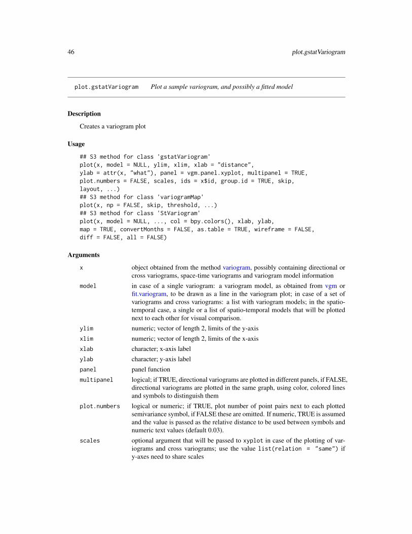
46 plot.gstatVariogram
plot.gstatVariogram Plot a sample variogram, and possibly a fitted model
Description
Creates a variogram plot
Usage
## S3 method for class 'gstatVariogram'plot(x, model = NULL, ylim, xlim, xlab = "distance",ylab = attr(x, "what"), panel = vgm.panel.xyplot, multipanel = TRUE,plot.numbers = FALSE, scales, ids = x$id, group.id = TRUE, skip,layout, ...)## S3 method for class 'variogramMap'plot(x, np = FALSE, skip, threshold, ...)## S3 method for class 'StVariogram'plot(x, model = NULL, ..., col = bpy.colors(), xlab, ylab,map = TRUE, convertMonths = FALSE, as.table = TRUE, wireframe = FALSE,diff = FALSE, all = FALSE)
Arguments
x object obtained from the method variogram, possibly containing directional orcross variograms, space-time variograms and variogram model information
model in case of a single variogram: a variogram model, as obtained from vgm orfit.variogram, to be drawn as a line in the variogram plot; in case of a set ofvariograms and cross variograms: a list with variogram models; in the spatio-temporal case, a single or a list of spatio-temporal models that will be plottednext to each other for visual comparison.
ylim numeric; vector of length 2, limits of the y-axis
xlim numeric; vector of length 2, limits of the x-axis
xlab character; x-axis label
ylab character; y-axis label
panel panel function
multipanel logical; if TRUE, directional variograms are plotted in different panels, if FALSE,directional variograms are plotted in the same graph, using color, colored linesand symbols to distinguish them
plot.numbers logical or numeric; if TRUE, plot number of point pairs next to each plottedsemivariance symbol, if FALSE these are omitted. If numeric, TRUE is assumedand the value is passed as the relative distance to be used between symbols andnumeric text values (default 0.03).
scales optional argument that will be passed to xyplot in case of the plotting of var-iograms and cross variograms; use the value list(relation = "same") ify-axes need to share scales

plot.gstatVariogram 47
ids ids of the data variables and variable pairs
group.id logical; control for directional multivariate variograms: if TRUE, panels di-vide direction and colors indicate variables (ids), if FALSE panels divide vari-ables/variable pairs and colors indicate direction
skip logical; can be used to arrange panels, see xyplot
layout integer vector; can be used to set panel layout: c(ncol,nrow)
np logical (only for plotting variogram maps); if TRUE, plot number of point pairs,if FALSE plot semivariances
threshold semivariogram map values based on fewer point pairs than threshold will not beplotted
... any arguments that will be passed to the panel plotting functions (such as auto.keyin examples below)
col colors to use
map logical; if TRUE, plot space-time variogram map
convertMonths logical; if TRUE, yearmon time lags will be unit converted and plotted as (inte-ger) months, and no longer match the numeric representation of yearmon, whichhas years as unit
as.table controls the plotting order for multiple panels, see xyplot for details.
wireframe logical; if TRUE, produce a wireframe plot
diff logical; if TRUE, plot difference between model and sample variogram; ignoresall.
all logical; if TRUE, plot sample and model variogram(s) in single wireframes.
Details
Please note that in the spatio-temporal case the levelplot and wireframe plots use the spatial dis-tances averaged for each time lag avgDist. For strongly varying spatial locations over time,please check the distance columns dist and avgDist of the spatio-temporal sample variogram.The lattice::cloud function is one option to plot irregular 3D data.
Value
returns (or plots) the variogram plot
Note
currently, plotting models and/or point pair numbers is not supported when a variogram is bothdirectional and multivariable; also, three-dimensional directional variograms will probably not bedisplayed correctly.
Author(s)
Edzer Pebesma

48 plot.pointPairs
References
http://www.gstat.org
See Also
variogram, fit.variogram, vgm variogramLine,
Examples
library(sp)data(meuse)coordinates(meuse) = ~x+yvgm1 <- variogram(log(zinc)~1, meuse)plot(vgm1)model.1 <- fit.variogram(vgm1,vgm(1,"Sph",300,1))plot(vgm1, model=model.1)plot(vgm1, plot.numbers = TRUE, pch = "+")vgm2 <- variogram(log(zinc)~1, meuse, alpha=c(0,45,90,135))plot(vgm2)# the following demonstrates plotting of directional models:model.2 <- vgm(.59,"Sph",926,.06,anis=c(0,0.3))plot(vgm2, model=model.2)
g = gstat(NULL, "zinc < 200", I(zinc<200)~1, meuse)g = gstat(g, "zinc < 400", I(zinc<400)~1, meuse)g = gstat(g, "zinc < 800", I(zinc<800)~1, meuse)# calculate multivariable, directional variogram:v = variogram(g, alpha=c(0,45,90,135))plot(v, group.id = FALSE, auto.key = TRUE) # id and id pairs panelsplot(v, group.id = TRUE, auto.key = TRUE) # direction panels
# variogram maps:plot(variogram(g, cutoff=1000, width=100, map=TRUE),
main = "(cross) semivariance maps")plot(variogram(g, cutoff=1000, width=100, map=TRUE), np=TRUE,
main = "number of point pairs")
plot.pointPairs Plot a point pairs, identified from a variogram cloud
Description
Plot a point pairs, identified from a variogram cloud
Usage
## S3 method for class 'pointPairs'plot(x, data, xcol = data$x, ycol = data$y, xlab = "x coordinate",ylab = "y coordinate", col.line = 2, line.pch = 0, main = "selected point pairs", ...)

plot.pointPairs 49
Arguments
x object of class "pointPairs", obtained from the function plot.variogramCloud,containing point pair indices
data data frame to which the indices refer (from which the variogram cloud was cal-culated)
xcol numeric vector with x-coordinates of data
ycol numeric vector with y-coordinates of data
xlab x-axis label
ylab y-axis label
col.line color for lines connecting points
line.pch if non-zero, symbols are also plotted at the middle of line segments, to marklines too short to be visible on the plot; the color used is col.line; the valuepassed to this argument will be used as plotting symbol (pch)
main title of plot
... arguments, further passed to xyplot
Value
plots the data locations, with lines connecting the point pairs identified (and refered to by indicesin) x
Author(s)
Edzer Pebesma
References
http://www.gstat.org
See Also
plot.variogramCloud
Examples
### The following requires interaction, and is therefore outcommented#data(meuse)#coordinates(meuse) = ~x+y#vgm1 <- variogram(log(zinc)~1, meuse, cloud = TRUE)#pp <- plot(vgm1, id = TRUE)### Identify the point pairs#plot(pp, data = meuse) # meuse has x and y as coordinates

50 plot.variogramCloud
plot.variogramCloud Plot and Identify Data Pairs on Sample Variogram Cloud
Description
Plot a sample variogram cloud, possibly with identification of individual point pairs
Usage
## S3 method for class 'variogramCloud'plot(x, identify = FALSE, digitize = FALSE, xlim, ylim, xlab, ylab,keep = FALSE, ...)
Arguments
x object of class variogramCloud
identify logical; if TRUE, the plot allows identification of a series of individual pointpairs that correspond to individual variogram cloud points (use left mouse buttonto select; right mouse button ends)
digitize logical; if TRUE, select point pairs by digitizing a region with the mouse (leftmouse button adds a point, right mouse button ends)
xlim limits of x-axis
ylim limits of y-axis
xlab x axis label
ylab y axis label
keep logical; if TRUE and identify is TRUE, the labels identified and their positionare kept and glued to object x, which is returned. Subsequent calls to plot thisobject will now have the labels shown, e.g. to plot to hardcopy
... parameters that are passed through to plot.gstatVariogram (in case of identify =FALSE) or to plot (in case of identify = TRUE)
Value
If identify or digitize is TRUE, a data frame of class pointPairs with in its rows the pointpairs identified (pairs of row numbers in the original data set); if identify is F, a plot of the variogramcloud, which uses plot.gstatVariogram
If in addition to identify, keep is also TRUE, an object of class variogramCloud is returned, hav-ing attached to it attributes "sel" and "text", which will be used in subsequent calls to plot.variogramCloudwith identify set to FALSE, to plot the text previously identified.
If in addition to digitize, keep is also TRUE, an object of class variogramCloud is returned,having attached to it attribute "poly", which will be used in subsequent calls to plot.variogramCloudwith digitize set to FALSE, to plot the digitized line.
In both of the keep = TRUE cases, the attribute ppairs of class pointPairs is present, containingthe point pairs identified.

predict 51
Author(s)
Edzer Pebesma
References
http://www.gstat.org/
See Also
variogram, plot.gstatVariogram, plot.pointPairs, identify, locator
Examples
library(sp)data(meuse)coordinates(meuse) = ~x+yplot(variogram(log(zinc)~1, meuse, cloud=TRUE))## commands that require interaction:# x <- variogram(log(zinc)~1, loc=~x+y, data=meuse, cloud=TRUE)# plot(plot(x, identify = TRUE), meuse)# plot(plot(x, digitize = TRUE), meuse)
predict Multivariable Geostatistical Prediction and Simulation
Description
The function provides the following prediction methods: simple, ordinary, and universal kriging,simple, ordinary, and universal cokriging, point- or block-kriging, and conditional simulation equiv-alents for each of the kriging methods.
Usage
## S3 method for class 'gstat'predict(object, newdata, block = numeric(0), nsim = 0,indicators = FALSE, BLUE = FALSE, debug.level = 1, mask,na.action = na.pass, sps.args = list(n = 500, type = "regular",offset = c(.5, .5)), ...)
Arguments
object object of class gstat, see gstat and krige
newdata data frame with prediction/simulation locations; should contain columns withthe independent variables (if present) and the coordinates with names as definedin locations; or: polygons, see below

52 predict
block block size; a vector with 1, 2 or 3 values containing the size of a rectangularin x-, y- and z-dimension respectively (0 if not set), or a data frame with 1, 2or 3 columns, containing the points that discretize the block in the x-, y- andz-dimension to define irregular blocks relative to (0,0) or (0,0,0)—see also thedetails section below. By default, predictions or simulations refer to the supportof the data values.
nsim integer; if set to a non-zero value, conditional simulation is used instead ofkriging interpolation. For this, sequential Gaussian or indicator simulation isused (depending on the value of indicators), following a single random paththrough the data.
indicators logical; only relevant if nsim is non-zero; if TRUE, use indicator simulation,else use Gaussian simulation
BLUE logical; if TRUE return the BLUE trend estimates only, if FALSE return theBLUP predictions (kriging)
debug.level integer; set gstat internal debug level, see below for useful values. If set to -1 (orany negative value), a progress counter is printed
mask not supported anymore – use na.action; logical or numerical vector; pattern withvalid values in newdata (marked as TRUE, non-zero, or non-NA); if mask isspecified, the returned data frame will have the same number and order of rowsin newdata, and masked rows will be filled with NA’s.
na.action function determining what should be done with missing values in ’newdata’.The default is to predict ’NA’. Missing values in coordinates and predictors areboth dealt with.
sps.args when newdata is of class SpatialPolygons or SpatialPolygonsDataFramethis argument list gets passed to spsample to control the discretizing of polygons
... ignored (but necessary for the S3 generic/method consistency)
Details
When a non-stationary (i.e., non-constant) mean is used, both for simulation and prediction pur-poses the variogram model defined should be that of the residual process, not that of the raw obser-vations.
For irregular block kriging, coordinates should discretize the area relative to (0), (0,0) or (0,0,0);the coordinates in newdata should give the centroids around which the block should be located.So, suppose the block is discretized by points (3,3) (3,5) (5,5) and (5,3), we should pass point(4,4) in newdata and pass points (-1,-1) (-1,1) (1,1) (1,-1) to the block argument. Although passingthe uncentered block and (0,0) as newdata may work for global neighbourhoods, neighbourhoodselection is always done relative to the centroid values in newdata.
If newdata is of class SpatialPolygons or SpatialPolygonsDataFrame, then the block average foreach of the polygons or polygon sets is calculated, using spsample to discretize the polygon(s).Argument sps.args controls the parameters used for spsample. The "location" with respect towhich neighbourhood selection is done is for each polygon the SpatialPolygons polygon label point;if you use local neighbourhoods you should check out where these points are—it may be welloutside the polygon itself.
The algorithm used by gstat for simulation random fields is the sequential simulation algorithm.This algorithm scales well to large or very large fields (e.g., more than $10^6$ nodes). Its power

predict 53
lies in using only data and simulated values in a local neighbourhood to approximate the conditionaldistribution at that location, see nmax in krige and gstat. The larger nmax, the better the approxi-mation, the smaller nmax, the faster the simulation process. For selecting the nearest nmax data orpreviously simulated points, gstat uses a bucket PR quadtree neighbourhood search algorithm; seethe reference below.
For sequential Gaussian or indicator simulations, a random path through the simulation locationsis taken, which is usually done for sequential simulations. The reason for this is that the localapproximation of the conditional distribution, using only the nmax neareast observed (or simulated)values may cause spurious correlations when a regular path would be followed. Following a singlepath through the locations, gstat reuses the expensive results (neighbourhood selection and solutionto the kriging equations) for each of the subsequent simulations when multiple realisations arerequested. You may expect a considerable speed gain in simulating 1000 fields in a single call topredict, compared to 1000 calls, each for simulating a single field.
The random number generator used for generating simulations is the native random number gen-erator of the environment (R, S); fixing randomness by setting the random number seed withset.seed() works.
When mean coefficient are not supplied, they are generated as well from their conditional distri-bution (assuming multivariate normal, using the generalized least squares BLUE estimate and itsestimation covariance); for a reference to the algorithm used see Abrahamsen and Benth, Math.Geol. 33(6), page 742 and leave out all constraints.
Memory requirements for sequential simulation: let n be the product of the number of variables,the number of simulation locations, and the number of simulations required in a single call. thegstat C function gstat_predict requires a table of size n * 12 bytes to pass the simulations backto R, before it can free n * 4 bytes. Hopefully, R does not have to duplicate the remaining n * 8bytes when the coordinates are added as columns, and when the resulting matrix is coerced to adata.frame.
Useful values for debug.level: 0: suppres any output except warning and error messages; 1:normal output (default): short data report, program action and mode, program progress in %, totalexecution time; 2: print the value of all global variables, all files read and written, and includesource file name and line number in error messages; 4: print OLS and WLS fit diagnostics; 8: printall data after reading them; 16: print the neighbourhood selection for each prediction location; 32:print (generalised) covariance matrices, design matrices, solutions, kriging weights, etc.; 64: printvariogram fit diagnostics (number of iterations and variogram model in each iteration step) andorder relation violations (indicator kriging values before and after order relation correction); 512:print block (or area) discretization data for each prediction location. To combine settings, sum theirrespective values. Negative values for debug.level are equal to positive, but cause the progresscounter to work.
For data with longitude/latitude coordinates (checked by is.projected), gstat uses great circledistances in km to compute spatial distances. The user should make sure that the semivariogrammodel used is positive definite on a sphere.
Value
a data frame containing the coordinates of newdata, and columns of prediction and predictionvariance (in case of kriging) or the columns of the conditional Gaussian or indicator simulations

54 predict
Author(s)
Edzer Pebesma
References
N.A.C. Cressie, 1993, Statistics for Spatial Data, Wiley.
http://www.gstat.org/
Pebesma, E.J., 2004. Multivariable geostatistics in S: the gstat package. Computers \& Geo-sciences, 30: 683-691.
For bucket PR quadtrees, excellent demos are found at http://www.cs.umd.edu/~brabec/quadtree/index.html
See Also
gstat, krige
Examples
# generate 5 conditional simulationslibrary(sp)data(meuse)coordinates(meuse) = ~x+yv <- variogram(log(zinc)~1, meuse)m <- fit.variogram(v, vgm(1, "Sph", 300, 1))plot(v, model = m)set.seed(131)data(meuse.grid)gridded(meuse.grid) = ~x+ysim <- krige(formula = log(zinc)~1, meuse, meuse.grid, model = m,nmax = 10, beta = 5.9, nsim = 5) # for speed -- 10 is too small!!# show all 5 simulationspplot(sim)
# calculate generalised least squares residuals w.r.t. constant trend:g <- gstat(NULL, "log.zinc", log(zinc)~1, meuse, model = m)blue0 <- predict(g, newdata = meuse, BLUE = TRUE)blue0$blue.res <- log(meuse$zinc) - blue0$log.zinc.predbubble(blue0, zcol = "blue.res", main = "GLS residuals w.r.t. constant")
# calculate generalised least squares residuals w.r.t. linear trend:m <- fit.variogram(variogram(log(zinc)~sqrt(dist.m), meuse),vgm(1, "Sph", 300, 1))g <- gstat(NULL, "log.zinc", log(zinc)~sqrt(dist.m), meuse, model = m)blue1 <- predict(g, meuse, BLUE = TRUE)blue1$blue.res <- log(meuse$zinc) - blue1$log.zinc.predbubble(blue1, zcol = "blue.res",main = "GLS residuals w.r.t. linear trend")
# unconditional simulation on a 100 x 100 gridxy <- expand.grid(1:100, 1:100)

progress 55
names(xy) <- c("x","y")gridded(xy) = ~x+yg.dummy <- gstat(formula = z~1, dummy = TRUE, beta = 0,model = vgm(1,"Exp",15), nmax = 10) # for speed -- 10 is too small!!yy <- predict(g.dummy, xy, nsim = 4)# show one realisation:spplot(yy[1])# show all four:spplot(yy)
progress Get or set progress indicator
Description
Get or set progress indicator
Usage
get_gstat_progress()set_gstat_progress(value)
Arguments
value logical
Value
return the logical value indicating whether progress bars should be given
Author(s)
Edzer Pebesma
Examples
set_gstat_progress(FALSE)get_gstat_progress()

56 show.vgms
show.vgms Plot Variogram Model Functions
Description
Creates a trellis plot for a range of variogram models, possibly with nugget; and optionally a set ofMatern models with varying smoothness.
Usage
show.vgms(min = 1e-12 * max, max = 3, n = 50, sill = 1, range = 1,models = as.character(vgm()$short[c(1:17)]), nugget = 0, kappa.range = 0.5,
plot = TRUE, ..., as.groups = FALSE)
Arguments
min numeric; start distance value for semivariance calculation beyond the first pointat exactly zero
max numeric; maximum distance for semivariance calculation and plotting
n integer; number of points to calculate distance values
sill numeric; (partial) sill(s) of the variogram model
range numeric; range(s) of the variogram model
models character; variogram model(s) to be plotted
nugget numeric; nugget component(s) for variogram models
kappa.range numeric; if this is a vector with more than one element, only a range of Maternmodels is plotted with these kappa values
plot logical; if TRUE, a plot is returned with the models specified; if FALSE, thedata prepared for this plot is returned
... passed on to the call to xyplot
as.groups logical; if TRUE, different models are plotted with different lines in a singlepanel, else, in one panel per model
Value
returns a (Trellis) plot of the variogram models requested; see examples. I do currently have strongdoubts about the “correctness” of the “Hol” model. The “Spl” model does seem to need a very largerange value (larger than the study area?) to be of some value.
If plot is FALSE, a data frame with the data prepared to plot is being returned.
Note
the min argument is supplied because the variogram function may be discontinuous at distance zero,surely when a positive nugget is present.

sic2004 57
Author(s)
Edzer Pebesma
References
http://www.gstat.org
See Also
vgm, variogramLine,
Examples
show.vgms()show.vgms(models = c("Exp", "Mat", "Gau"), nugget = 0.1)# show a set of Matern models with different smoothness:show.vgms(kappa.range = c(.1, .2, .5, 1, 2, 5, 10), max = 10)# show a set of Exponential class models with different shape parameter:show.vgms(kappa.range = c(.05, .1, .2, .5, 1, 1.5, 1.8, 1.9, 2), models = "Exc", max = 10)# show a set of models with different shape parameter of M. Stein's representation of the Matern:show.vgms(kappa.range = c(.01, .02, .05, .1, .2, .5, 1, 2, 5, 1000), models = "Ste", max = 2)
sic2004 Spatial Interpolation Comparison 2004 data set: Natural AmbientRadioactivity
Description
The text below was copied from the original sic2004 event, which is no longer online available.
The variable used in the SIC 2004 exercise is natural ambient radioactivity measured in Germany.The data, provided kindly by the German Federal Office for Radiation Protection (BfS), are gammadose rates reported by means of the national automatic monitoring network (IMIS).
In the frame of SIC2004, a rectangular area was used to select 1008 monitoring stations (from a totalof around 2000 stations). For these 1008 stations, 11 days of measurements have been randomlyselected during the last 12 months and the average daily dose rates calculated for each day. Hence,we ended up having 11 data sets.
Prior information (sic.train): 10 data sets of 200 points that are identical for what concerns the loca-tions of the monitoring stations have been prepared. These locations have been randomly selected(see Figure 1). These data sets differ only by their Z values since each set corresponds to 1 dayof measurement made during the last 14 months. No information will be provided on the date ofmeasurement. These 10 data sets (10 days of measurements) can be used as prior information totune the parameters of the mapping algorithms. No other information will be provided about thesesets. Participants are free of course to gather more information about the variable in the literatureand so on.

58 sic2004
The 200 monitoring stations above were randomly taken from a larger set of 1008 stations. Theremaining 808 monitoring stations have a topology given in sic.pred. Participants to SIC2004 willhave to estimate the values of the variable taken at these 808 locations.
The SIC2004 data (sic.val, variable dayx): The exercise consists in using 200 measurements madeon a 11th day (THE data of the exercise) to estimate the values observed at the remaining 808 loca-tions (hence the question marks as symbols in the maps shown in Figure 3). These measurementswill be provided only during two weeks (15th of September until 1st of October 2004) on a webpage restricted to the participants. The true values observed at these 808 locations will be releasedonly at the end of the exercise to allow participants to write their manuscripts (sic.test, variablesdayx and joker).
In addition, a joker data set was released (sic.val, variable joker), which contains an anomaly. Theanomaly was generated by a simulation model, and does not represent measured levels.
Usage
data(sic2004) #
Format
The data frames contain the following columns:
record this integer value is the number (unique value) of the monitoring station chosen by us.
x X-coordinate of the monitoring station indicated in meters
y Y-coordinate of the monitoring station indicated in meters
day01 mean gamma dose rate measured during 24 hours, at day01. Units are nanoSieverts/hour
day02 same, for day 02
day03 ...
day04 ...
day05 ...
day06 ...
day07 ...
day08 ...
day09 ...
day10 ...
dayx the data observed at the 11-th day
joker the joker data set, containing an anomaly not present in the training data
Note
the data set sic.grid provides a set of points on a regular grid (almost 10000 points) covering thearea; this is convenient for interpolation; see the function makegrid in package sp.
The coordinates have been projected around a point located in the South West of Germany. Hence,a few coordinates have negative values as can be guessed from the Figures below.

sic97 59
Author(s)
Data: the German Federal Office for Radiation Protection (BfS), http://www.bfs.de/, data pro-vided by Gregoire Dubois, R compilation by Edzer Pebesma.
References
https://wiki.52north.org/bin/view/AI_GEOSTATS/WebHome
Examples
data(sic2004)# FIGURE 1. Locations of the 200 monitoring stations for the 11 data sets.# The values taken by the variable are known.plot(y~x,sic.train,pch=1,col="red", asp=1)
# FIGURE 2. Locations of the 808 remaining monitoring stations at which# the values of the variable must be estimated.plot(y~x,sic.pred,pch="?", asp=1, cex=.8) # Figure 2
# FIGURE 3. Locations of the 1008 monitoring stations (exhaustive data sets).# Red circles are used to estimate values located at the questions marksplot(y~x,sic.train,pch=1,col="red", asp=1)points(y~x, sic.pred, pch="?", cex=.8)
sic97 Spatial Interpolation Comparison 1997 data set: Swiss Rainfall
Description
The text below is copied from the data item at ai-geostats, https://wiki.52north.org/bin/view/AI_GEOSTATS/WebHome
Usage
data(sic97) #
Format
The data frames contain the following columns:
ID this integer value is the number (unique value) of the monitoring station
rainfall rainfall amount, in 10th of mm
Note
See the pdf that accompanies the original file for a description of the data. The .dxf file with theSwiss border is not included here.

60 spplot.vcov
Author(s)
Gregoire Dubois and others.
References
https://wiki.52north.org/bin/view/AI_GEOSTATS/WebHome
Examples
data(sic97)image(demstd)points(sic_full, pch=1)points(sic_obs, pch=3)
spplot.vcov Plot map matrix of prediction error variances and covariances
Description
Plot map matrix of prediction error variances and covariances
Usage
spplot.vcov(x, ...)
Arguments
x Object of class SpatialPixelsDataFrame or SpatialGridDataFrame, resulting froma krige call with multiple variables (cokriging
... remaining arguments passed to spplot
Value
The plotted object, of class trellis; see spplot in package sp.
Author(s)
Edzer Pebesma

tull 61
tull NA
Description
The Südliche Tullnerfeld is a part of the Danube river basin in central Lower Austria and due to itshomogeneous aquifer well suited for a model-oriented geostatistical analysis. It contains 36 officialwater quality measurement stations, which are irregularly spread over the region.
Usage
data(tull)
Format
The data frames contain the following columns:
x X location in meter
y Y location in meter
S411 Station name
S429 Station name
S849 Station name
S854 Station name
S1502 Station name
S1584 Station name
S1591 Station name
S2046 Station name
S2047 Station name
S2048 Station name
S2049 Station name
S2051 Station name
S2052 Station name
S2053 Station name
S2054 Station name
S2055 Station name
S2057 Station name
S2058 Station name
S2059 Station name
S2060 Station name
S2061 Station name

62 tull
S2062 Station name
S2063 Station name
S2064 Station name
S2065 Station name
S2066 Station name
S2067 Station name
S2070 Station name
S2071 Station name
S2072 Station name
S2128 Station name
S5319 Station name
S5320 Station name
S5321 Station name
S5322 Station name
S5323 Station name
Note
This data set was obtained on May 6, 2008 from http://www.ifas.jku.at/e5361/index_ger.html. The author of the book that uses it is found at: http://www.ifas.jku.at/e2571/e2604/index_ger.html
References
Werner G. Müller, Collecting Spatial Data, 3rd edition. Springer Verlag, Heidelberg, 2007
Examples
data(tull)
# TULLNREG = read.csv("TULLNREG.csv")
# I modified tulln36des.csv, such that the first line only contained: x,y# resulting in row.names that reflect the station ID, as in# tull36 = read.csv("tulln36des.csv")
# Chlorid92 was read & converted by:#Chlorid92=read.csv("Chlorid92.csv")#Chlorid92$Datum = as.POSIXct(strptime(Chlorid92$Datum, "%d.%m.%y"))
summary(tull36)summary(TULLNREG)summary(Chlorid92)
# stack & join data to x,y,Date,Chloride form:cl.st = stack(Chlorid92[-1])

variogram 63
names(cl.st) = c("Chloride", "Station")cl.st$Date = rep(Chlorid92$Datum, length(names(Chlorid92))-1)cl.st$x = tull36[match(cl.st[,"Station"], row.names(tull36)), "x"]cl.st$y = tull36[match(cl.st[,"Station"], row.names(tull36)), "y"]# library(lattice)# xyplot(Chloride~Date|Station, cl.st)# xyplot(y~x|Date, cl.st, asp="iso", layout=c(16,11))summary(cl.st)plot(TULLNREG, pch=3, asp=1)points(y~x, cl.st, add=TRUE, pch=16)
variogram Calculate Sample or Residual Variogram or Variogram Cloud
Description
Calculates the sample variogram from data, or in case of a linear model is given, for the residuals,with options for directional, robust, and pooled variogram, and for irregular distance intervals.
In case spatio-temporal data is provided, the function variogramST is called with a different set ofparameters.
Usage
## S3 method for class 'gstat'variogram(object, ...)## S3 method for class 'formula'variogram(object, locations = coordinates(data), data, ...)## Default S3 method:variogram(object, locations, X, cutoff, width = cutoff/15,alpha = 0, beta = 0, tol.hor = 90/length(alpha), tol.ver =90/length(beta), cressie = FALSE, dX = numeric(0), boundaries =numeric(0), cloud = FALSE, trend.beta = NULL, debug.level = 1,cross = TRUE, grid, map = FALSE, g = NULL, ..., projected = TRUE,lambda = 1.0, verbose = FALSE, covariogram = FALSE, PR = FALSE,pseudo = -1)## S3 method for class 'gstatVariogram'print(x, ...)## S3 method for class 'variogramCloud'print(x, ...)
Arguments
object object of class gstat; in this form, direct and cross (residual) variograms arecalculated for all variables and variable pairs defined in object; in case ofvariogram.formula, formula defining the response vector and (possible) re-gressors, in case of absence of regressors, use e.g. z~1; in case of variogram.default:list with for each variable the vector with responses (should not be called di-rectly)

64 variogram
data data frame where the names in formula are to be found
locations spatial data locations. For variogram.formula: a formula with only the coor-dinate variables in the right hand (explanatory variable) side e.g. ~x+y; seeexamples.For variogram.default: list with coordinate matrices, each with the number ofrows matching that of corresponding vectors in y; the number of columns shouldmatch the number of spatial dimensions spanned by the data (1 (x), 2 (x,y) or 3(x,y,z)).
... any other arguments that will be passed to variogram.default (ignored)
X (optional) list with for each variable the matrix with regressors/covariates; thenumber of rows should match that of the correspoding element in y, the numberof columns equals the number of regressors (including intercept)
cutoff spatial separation distance up to which point pairs are included in semivarianceestimates; as a default, the length of the diagonal of the box spanning the data isdivided by three.
width the width of subsequent distance intervals into which data point pairs are groupedfor semivariance estimates
alpha direction in plane (x,y), in positive degrees clockwise from positive y (North):alpha=0 for direction North (increasing y), alpha=90 for direction East (increas-ing x); optional a vector of directions in (x,y)
beta direction in z, in positive degrees up from the (x,y) plane; optional a vector ofdirections
tol.hor horizontal tolerance angle in degrees
tol.ver vertical tolerance angle in degrees
cressie logical; if TRUE, use Cressie”s robust variogram estimate; if FALSE use theclassical method of moments variogram estimate
dX include a pair of data points $y(s_1),y(s_2)$ taken at locations $s_1$ and $s_2$for sample variogram calculation only when $||x(s_1)-x(s_2)|| < dX$ with and$x(s_i)$ the vector with regressors at location $s_i$, and $||.||$ the 2-norm. Thisallows pooled estimation of within-strata variograms (use a factor variable asregressor, and dX=0.5), or variograms of (near-)replicates in a linear model (ad-dressing point pairs having similar values for regressors variables)
boundaries numerical vector with distance interval upper boundaries; values should be strictlyincreasing
cloud logical; if TRUE, calculate the semivariogram cloud
trend.beta vector with trend coefficients, in case they are known. By default, trend coeffi-cients are estimated from the data.
debug.level integer; set gstat internal debug level
cross logical or character; if FALSE, no cross variograms are computed when ob-ject is of class gstat and has more than one variable; if TRUE, all direct andcross variograms are computed; if equal to "ST", direct and cross variogramsare computed for all pairs involving the first (non-time lagged) variable; if equalto "ONLY", only cross variograms are computed (no direct variograms).

variogram 65
formula formula, specifying the dependent variable and possible covariatesx object of class variogram or variogramCloud to be printedgrid grid parameters, if data are gridded (not to be called directly; this is filled auto-
matically)map logical; if TRUE, and cutoff and width are given, a variogram map is returned.
This requires package sp. Alternatively, a map can be passed, of class Spatial-DataFrameGrid (see sp docs)
g NULL or object of class gstat; may be used to pass settable parameters and/orvariograms; see example
projected logical; if FALSE, data are assumed to be unprojected, meaning decimal longi-tude/latitude. For projected data, Euclidian distances are computed, for unpro-jected great circle distances (km). In variogram.formula or variogram.gstat,for data deriving from class Spatial, projection is detected automatically usingis.projected
lambda test feature; not working (yet)verbose logical; print some progress indicationpseudo integer; use pseudo cross variogram for computing time-lagged spatial vari-
ograms? -1: find out from coordinates – if they are equal then yes, else no;0: no; 1: yes.
covariogram logical; compute covariogram instead of variogram?PR logical; compute pairwise relative variogram (does NOT check whether variable
is strictly positive)
Value
If map is TRUE (or a map is passed), a grid map is returned containing the (cross) variogram map(s).See package sp.
In other cases, an object of class "gstatVariogram" with the following fields:
np the number of point pairs for this estimate; in case of a variogramCloud seebelow
dist the average distance of all point pairs considered for this estimategamma the actual sample variogram estimatedir.hor the horizontal directiondir.ver the vertical directionid the combined id pair
If cloud is TRUE: an object of class variogramCloud, with the field np encoding the numbers ofthe point pair that contributed to a variogram cloud estimate, as follows. The first point is found by1 + the integer division of np by the .BigInt attribute of the returned object, the second point by1 + the remainder of that division. as.data.frame.variogramCloud returns no np field, but does thedecoding into:
left for variogramCloud: data id (row number) of one of the data pairright for variogramCloud: data id (row number) of the other data in the pair
In case of a spatio-temporal variogram is sought see variogramST for details.

66 variogram
Note
variogram.default should not be called by users directly, as it makes many assumptions aboutthe organization of the data, that are not fully documented (but of course, can be understood fromreading the source code of the other variogram methods)
Successfully setting gridded() <- TRUE may trigger a branch that will fail unless dx and dy areidentical, and not merely similar to within machine epsilon.
Note
variogram.line is DEPRECATED; it is and was never meant as a variogram method, but worksautomatically as such by the R dispatch system. Use variogramLine instead.
Author(s)
Edzer Pebesma
References
Cressie, N.A.C., 1993, Statistics for Spatial Data, Wiley.
Cressie, N., C. Wikle, 2011, Statistics for Spatio-temporal Data, Wiley.
http://www.gstat.org/
Pebesma, E.J., 2004. Multivariable geostatistics in S: the gstat package. Computers \& Geo-sciences, 30: 683-691.
See Also
print.gstatVariogram, plot.gstatVariogram, plot.variogramCloud; for variogram models: vgm, to fita variogram model to a sample variogram: fit.variogram variogramST for details on the spatio-temporal sample variogram.
Examples
library(sp)data(meuse)# no trend:coordinates(meuse) = ~x+yvariogram(log(zinc)~1, meuse)# residual variogram w.r.t. a linear trend:variogram(log(zinc)~x+y, meuse)# directional variogram:variogram(log(zinc)~x+y, meuse, alpha=c(0,45,90,135))variogram(log(zinc)~1, meuse, width=90, cutoff=1300)
# GLS residual variogram:v = variogram(log(zinc)~x+y, meuse)v.fit = fit.variogram(v, vgm(1, "Sph", 700, 1))v.fitset = list(gls=1)v

variogramLine 67
g = gstat(NULL, "log-zinc", log(zinc)~x+y, meuse, model=v.fit, set = set)variogram(g)
if (require(rgdal)) {proj4string(meuse) = CRS("+init=epsg:28992")meuse.ll = spTransform(meuse, CRS("+proj=longlat +datum=WGS84 +ellps=WGS84"))
# variogram of unprojected data, using great-circle distances, returning km as unitsvariogram(log(zinc) ~ 1, meuse.ll)
}
variogramLine Semivariance Values For a Given Variogram Model
Description
Generates a semivariance values given a variogram model
Usage
variogramLine(object, maxdist, n = 200, min = 1.0e-6 * maxdist,dir = c(1,0,0), covariance = FALSE, ..., dist_vector, debug.level = 0)
Arguments
object variogram model for which we want semivariance function values
maxdist maximum distance for which we want semivariance values
n number of points
min minimum distance; a value slightly larger than zero is usually used to avoid thediscontinuity at distance zero if a nugget component is present
dir direction vector: unit length vector pointing the direction in x (East-West), y(North-South) and z (Up-Down)
covariance logical; if TRUE return covariance values, otherwise return semivariance values
... ignored
dist_vector numeric vector or matrix with distance values
debug.level gstat internal debug level
Value
a data frame of dimension (n x 2), with columns distance and gamma (semivariances or covari-ances), or in case dist_vector is a matrix, a conforming matrix with semivariance/covariancevalues is returned.
Note
variogramLine is used to generate data for plotting a variogram model.

68 variogramST
Author(s)
Edzer Pebesma
See Also
plot.gstatVariogram
Examples
variogramLine(vgm(5, "Exp", 10, 5), 10, 10)# anisotropic variogram, plotted in E-W direction:variogramLine(vgm(1, "Sph", 10, anis=c(0,0.5)), 10, 10)# anisotropic variogram, plotted in N-S direction:variogramLine(vgm(1, "Sph", 10, anis=c(0,0.5)), 10, 10, dir=c(0,1,0))variogramLine(vgm(1, "Sph", 10, anis=c(0,0.5)), dir=c(0,1,0), dist_vector = 0.5)variogramLine(vgm(1, "Sph", 10, anis=c(0,0.5)), dir=c(0,1,0), dist_vector = c(0, 0.5, 0.75))
variogramST Calculate Spatio-Temporal Sample Variogram
Description
Calculates the sample variogram from spatio-temporal data.
Usage
variogramST(formula, locations, data, ..., tlags = 0:15, cutoff,width = cutoff/15, boundaries = seq(0, cutoff, width),progress = interactive(), pseudo = TRUE, assumeRegular=FALSE, na.omit=FALSE)
Arguments
formula formula, specifying the dependent variable.
locations A STFDF or STSDF containing the variable; kept for compatibility reasons withvariogram, either locations or data must be provided.
data A STFDF, STSDF or STIDF containing the variable.
... any other arguments that will be passed to the underlying variogram function.In case of using data of type STIDF, the argument tunit is recommended to setthe temporal unit of the tlags. Additionally, twindow can be passed to controlthe temporal window used for temporal distance calculations. This builds on theproperty of xts being ordered and only the next twindow instances are consid-ered. This avoids the need of huge temporal distance matrices. The default usestwice the number as the average difference goes into the temporal cutoff.
tlags integer; time lags to consider or in case data is of class STIDF the actual tem-poral boundaries with time unit given by tunit otherwise the same unit as diffon the index of the time slot will generate is assumed.

variogramST 69
cutoff spatial separation distance up to which point pairs are included in semivarianceestimates; as a default, the length of the diagonal of the box spanning the data isdivided by three.
width the width of subsequent distance intervals into which data point pairs are groupedfor semivariance estimates, by default the cutoff is divided into 15 equal lags.
boundaries numerical vector with distance interval upper boundaries; values should be strictlyincreasing
progress logical; if TRUE, show text progress bar
pseudo integer; use pseudo cross variogram for computing time-lagged spatial vari-ograms? -1: find out from coordinates – if they are equal then yes, else no;0: no; 1: yes.
assumeRegular logical; whether the time series should be assumed regular. The first time stepis assumed to be representative for the whole series. Note, that temporal lagsare considered by index, and no check is made whether pairs actually have thedesired separating distance.
na.omit shall all NA values in the spatio-temporal variogram be dropped? In case wherecomplete rows or columns in the variogram consists of NA only, plot mightproduce a distorted picture.
Value
The spatio-temporal sample variogram contains besides the fields np, dist and gamma the spatio-temporal fields, timelag, spacelag and avgDist, the first of which indicates the time lag used,the second and third different spatial lags. spacelag is the midpoint in the spatial lag intervalsas passed by the parameter boundaries, whereas avgDist is the average distance between thepoint pairs found in a distance interval over all temporal lags (i.e. the averages of the values distper temporal lag.) To compute variograms for space lag $h$ and time lag $t$, the pseudo crossvariogram $(Z_i(s)-Z_i+t(s+h))^2$ is averaged over all time lagged observation sets $Z_i$ and$Z_i+t$ available (weighted by the number of pairs involved).
Author(s)
Edzer Pebesma, Benedikt Graeler
References
Cressie, N.A.C., 1993, Statistics for Spatial Data, Wiley.
Cressie, N., C. Wikle, 2011, Statistics for Spatio-temporal Data, Wiley.
http://www.gstat.org/
Pebesma, E.J., 2004. Multivariable geostatistics in S: the gstat package. Computers \& Geo-sciences, 30: 683-691.
See Also
plot.StVariogram, for variogram models: vgmST, to fit a spatio-temporal variogram model to aspatio-temporal sample variogram: fit.StVariogram

70 variogramSurface
Examples
# The following spatio-temporal variogram has been calcualted through# vv = variogram(PM10~1, r5to10, width=20, cutoff = 200, tlags=0:5)# in the vignette "st".
data(vv)str(vv)plot(vv)
variogramSurface Semivariance values for a given spatio-temporal variogram model
Description
Generates a surface of semivariance values given a spatio-temporal variogram model (one of sepa-rable, productSum, sumMetric, simpleSumMetric or metric)
Usage
variogramSurface(model, dist_grid, ...)
Arguments
model A spatio-temporal variogram model generated through vgmST or fit.StVariogram.
dist_grid A data.frame with two columns: spacelag and timelag.
... Additional arguments passed on to the underlying variogram functions.
Value
A data.frame with columns spacelag, timelag and gamma.
Author(s)
Benedikt Graeler
See Also
See variogramLine for the spatial version and fit.StVariogram for the estimation of spatio-temporal variograms.

vgm 71
Examples
separableModel <- vgmST("separable",space=vgm(0.86, "Exp", 476, 0.14),time =vgm( 1, "Exp", 3, 0),sill=113)
data(vv)
if(require(lattice)) {plot(vv, separableModel, wireframe=TRUE, all=TRUE)}
# plotting of sample and model variogramplot(vv, separableModel)
vgm Generate, or Add to Variogram Model
Description
Generates a variogram model, or adds to an existing model. print.variogramModel prints theessence of a variogram model.
Usage
vgm(psill = NA, model, range = NA, nugget, add.to, anis, kappa = 0.5, ..., covtable,Err = 0)## S3 method for class 'variogramModel'print(x, ...)as.vgm.variomodel(m)
Arguments
psill (partial) sill of the variogram model component, or model: see Details
model model type, e.g. "Exp", "Sph", "Gau", "Mat". Calling vgm() without a modelargument returns a data.frame with available models.
range range parameter of the variogram model component; in case of anisotropy: ma-jor range
kappa smoothness parameter for the Matern class of variogram models
nugget nugget component of the variogram (this basically adds a nugget compontent tothe model); if missing, nugget component is omitted
add.to the variogram model to which we want to add a component (structure)
anis anisotropy parameters: see notes below
x a variogram model to print

72 vgm
... arguments that will be passed to print, e.g. digits (see examples)
covtable if model is Tab, instead of model parameters a one-dimensional covariance tablecan be passed here. See covtable.R in tests directory, and example below.
Err numeric; if larger than zero, the measurement error variance component that willnot be included to the kriging equations, i.e. kriging will now smooth the processY instead of predict the measured Z, where Z=Y+e, and Err is the variance of e
m object of class variomodel, see geoR
Details
If only the first argument (psill) is given a character value indicating a model, as in vgm("Sph"),then this taken as a shorthand form of vgm(NA,"Sph",NA,NA), i.e. a spherical variogram withnugget and unknown parameter values; see examples below. Read fit.variogram to find out how NAvariogram parameters are given initial values for a fitting a model, based on the sample variogram.Package automap gives further options for automated variogram modelling.
Value
If a single model is passed, an object of class variogramModel extending data.frame.
In case a vector ofmodels is passed, an object of class variogramModelList which is a list ofvariogramModel objects.
When called without a model argument, a data.frame with available models is returned, having twocolumns: short (abbreviated names, to be used as model argument: "Exp", "Sph" etc) and long(with some description).
as.vgm.variomodel tries to convert an object of class variomodel (geoR) to vgm.
Note
Geometric anisotropy can be modelled for each individual simple model by giving two or fiveanisotropy parameters, two for two-dimensional and five for three-dimensional data. In any case,the range defined is the range in the direction of the strongest correlation, or the major range.Anisotropy parameters define which direction this is (the main axis), and how much shorter therange is in (the) direction(s) perpendicular to this main axis.
In two dimensions, two parameters define an anisotropy ellipse, say anis = c(30, 0.5). Thefirst parameter, 30, refers to the main axis direction: it is the angle for the principal direction ofcontinuity (measured in degrees, clockwise from positive Y, i.e. North). The second parameter,0.5, is the anisotropy ratio, the ratio of the minor range to the major range (a value between 0 and1). So, in our example, if the range in the major direction (North-East) is 100, the range in the minordirection (South-East) is 0.5 x 100 = 50.
In three dimensions, five values should be given in the form anis = c(p,q,r,s,t). Now, $p$is the angle for the principal direction of continuity (measured in degrees, clockwise from Y, indirection of X), $q$ is the dip angle for the principal direction of continuity (measured in positivedegrees up from horizontal), $r$ is the third rotation angle to rotate the two minor directions aroundthe principal direction defined by $p$ and $q$. A positive angle acts counter-clockwise whilelooking in the principal direction. Anisotropy ratios $s$ and $t$ are the ratios between the majorrange and each of the two minor ranges. The anisotropy code was taken from GSLIB. Note that inhttp://www.gslib.com/sec_gb.html it is reported that this code has a bug. Quoting from this

vgm 73
site: “The third angle in all GSLIB programs operates in the opposite direction than specified in theGSLIB book. Explanation - The books says (pp27) the angle is measured clockwise when lookingtoward the origin (from the postive principal direction), but it should be counter-clockwise. This isa documentation error. Although rarely used, the correct specification of the third angle is critical ifused.”
(Note that anis = c(p,s) is equivalent to anis = c(p,0,0,s,1).)
The implementation in gstat for 2D and 3D anisotropy was taken from the gslib (probably 1992)code. I have seen a paper where it is argued that the 3D anisotropy code implemented in gslib (andso in gstat) is in error, but I have not corrected anything afterwards.
Author(s)
Edzer Pebesma
References
http://www.gstat.org/
Pebesma, E.J., 2004. Multivariable geostatistics in S: the gstat package. Computers \& Geo-sciences, 30: 683-691.
Deutsch, C.V. and Journel, A.G., 1998. GSLIB: Geostatistical software library and user’s guide,second edition, Oxford University Press.
For the validity of variogram models on the sphere, see Huang, Chunfeng, Haimeng Zhang, andScott M. Robeson. On the validity of commonly used covariance and variogram functions on thesphere. Mathematical Geosciences 43.6 (2011): 721-733.
See Also
show.vgms to view the available models, fit.variogram, variogramLine, variogram for the samplevariogram.
Examples
vgm()vgm("Sph")vgm(NA, "Sph", NA, NA)vgm(, "Sph") # "Sph" is second argument: NO nugget in this casevgm(10, "Exp", 300)x <- vgm(10, "Exp", 300)vgm(10, "Nug", 0)vgm(10, "Exp", 300, 4.5)vgm(10, "Mat", 300, 4.5, kappa = 0.7)vgm( 5, "Exp", 300, add.to = vgm(5, "Exp", 60, nugget = 2.5))vgm(10, "Exp", 300, anis = c(30, 0.5))vgm(10, "Exp", 300, anis = c(30, 10, 0, 0.5, 0.3))# Matern variogram model:vgm(1, "Mat", 1, kappa=.3)x <- vgm(0.39527463, "Sph", 953.8942, nugget = 0.06105141)xprint(x, digits = 3);

74 vgm.panel.xyplot
# to see all components, doprint.data.frame(x)vv=vgm(model = "Tab", covtable =variogramLine(vgm(1, "Sph", 1), 1, n=1e4, min = 0, covariance = TRUE))vgm(c("Mat", "Sph"))vgm(, c("Mat", "Sph")) # no nugget
vgm.panel.xyplot panel functions for most of the variogram plots through lattice
Description
Variogram plots contain symbols and lines; more control over them can be gained by writing yourown panel functions, or extending the ones described here; see examples.
Usage
vgm.panel.xyplot(x, y, subscripts, type = "p", pch = plot.symbol$pch,col, col.line = plot.line$col, col.symbol = plot.symbol$col,lty = plot.line$lty, cex = plot.symbol$cex, ids, lwd = plot.line$lwd,model = model, direction = direction, labels, shift = shift, mode = mode, ...)
panel.pointPairs(x, y, type = "p", pch = plot.symbol$pch, col, col.line =plot.line$col, col.symbol = plot.symbol$col, lty = plot.line$lty,cex = plot.symbol$cex, lwd = plot.line$lwd, pairs = pairs,line.pch = line.pch, ...)
Arguments
x x coordinates of points in this panel
y y coordinates of points in this panel
subscripts subscripts of points in this panel
type plot type: "l" for connected lines
pch plotting symbol
col symbol and line color (if set)
col.line line color
col.symbol symbol color
lty line type for variogram model
cex symbol size
ids gstat model ids
lwd line width
model variogram model
direction direction vector c(dir.horizontal, dir.ver)
labels labels to plot next to points

vgmArea 75
shift amount to shift the label right of the symbol
mode to be set by calling function only
line.pch symbol type to be used for point of selected point pairs, e.g. to highlight pointpairs with distance close to zero
pairs two-column matrix with pair indexes to be highlighted
... parameters that get passed to lpoints
Value
ignored; the enclosing function returns a plot of class trellis
Author(s)
Edzer Pebesma
References
http://www.gstat.org/
See Also
plot.gstatVariogram, vgm
Examples
library(sp)data(meuse)coordinates(meuse) <- c("x", "y")library(lattice)mypanel = function(x,y,...) {vgm.panel.xyplot(x,y,...)panel.abline(h=var(log(meuse$zinc)), color = 'red')}plot(variogram(log(zinc)~1,meuse), panel = mypanel)
vgmArea point-point, point-area or area-area semivariance
Description
Compute point-point, point-area or area-area variogram values from point model
Usage
vgmArea(x, y = x, vgm, ndiscr = 16, verbose = FALSE, covariance = TRUE)

76 vgmST
Arguments
x object of class SpatialPoints or SpatialPolygons
y object of class SpatialPoints or SpatialPolygons
vgm variogram model, see vgm
ndiscr number of points to discretize an area, using spsample
verbose give progress bar
covariance logical; compute covariances, rather than semivariances?
Value
semivariance or covariance matrix of dimension length(x) x lenght(y)
Author(s)
Edzer Pebesma
Examples
library(sp)demo(meuse, ask = FALSE, echo = FALSE)vgmArea(meuse[1:5,], vgm = vgm(1, "Exp", 1000)) # point-pointvgmArea(meuse[1:5,], meuse.area, vgm = vgm(1, "Exp", 1000)) # point-area
vgmST Constructing a spatio-temporal variogram
Description
Constructs a spatio-temporal variogram of a given type checking for a minimal set of parameters.
Usage
vgmST(stModel, ..., space, time, joint, sill, k, nugget, stAni, temporalUnits)
Arguments
stModel A string identifying the spatio-temporal variogram model (see details below).Only the string before an optional "_" is used to identify the model. This mech-anism can be used to identify different fits of the same model (separable_Aand separable_B will be interpreted as separable models, but carry differentnames).
... unused, but ensure an exact match of the following parameters.
space A spatial variogram.
time A temporal variogram.
joint A joint spatio-temporal variogram.

vgmST 77
sill A joint spatio-temporal sill.
k The weighting of the product in the product-sum model.
nugget A joint spatio-temporal nugget.
stAni A spatio-temporal anisotropy; the number of space units equivalent to one timeunit.
temporalUnits length one character vector, indicating the temporal units (like secs)
Details
The different implemented spatio-temporal variogram models have the following required parame-ters (see as well the example section)
separable: A variogram for space and time each and a joint spatio-temporal sill (variogramsmay have a separate nugget effect, but their joint sill will be 1) generating the call
vgmST("separable", space, time, sill)
productSum: A variogram for space and time each, and the weighting of product k generatingthe call
vgmST("productSum", space, time, k)
sumMetric: A variogram (potentially including a nugget effect) for space, time and joint eachand a spatio-temporal anisotropy ratio stAni generating the call
vgmST("sumMetric", space, time, joint, stAni)
simpleSumMetric: A variogram (without nugget effect) for space, time and joint each, a jointspatio-temporal nugget effect and a spatio-temporal anisotropy ratio stAni generating thecall
vgmST("simpleSumMetric", space, time, joint, nugget, stAni)
metric: A spatio-temporal joint variogram (potentially including a nugget effect) and stAni gen-erating the call
vgmST("metric", joint, stAni)
Value
Returns an S3 object of class StVariogramModel.
Author(s)
Benedikt Graeler
See Also
fit.StVariogram for fitting, variogramSurface to plot the variogram and extractParNames tobetter understand the parameter structure of spatio-temporal variogram models.

78 vv
Examples
# separable model: spatial and temporal sill will be ignored# and kept constant at 1-nugget respectively. A joint sill is used.separableModel <- vgmST("separable",
space=vgm(0.9,"Exp", 147, 0.1),time =vgm(0.9,"Exp", 3.5, 0.1),sill=40)
# product sum model: spatial and temporal nugget will be ignored and kept# constant at 0. Only a joint nugget is used.prodSumModel <- vgmST("productSum",
space=vgm(39, "Sph", 343, 0),time= vgm(36, "Exp", 3, 0),k=15)
# sum metric model: spatial, temporal and joint nugget will be estimatedsumMetricModel <- vgmST("sumMetric",
space=vgm( 6.9, "Lin", 200, 3.0),time =vgm(10.3, "Lin", 15, 3.6),joint=vgm(37.2, "Exp", 84,11.7),stAni=77.7)
# simplified sumMetric model, only a overall nugget is fitted. The spatial,# temporal and jont nuggets are set to 0.simpleSumMetricModel <- vgmST("simpleSumMetric",
space=vgm(20,"Lin", 150, 0),time =vgm(20,"Lin", 10, 0),joint=vgm(20,"Exp", 150, 0),nugget=1, stAni=15)
# metric modelmetricModel <- vgmST("metric",
joint=vgm(60, "Exp", 150, 10),stAni=60)
vv Precomputed variogram for PM10 in data set air
Description
Precomputed variogram for PM10 in data set air
Usage
data(vv)
Format
data set structure is explained in variogramST.

walker 79
Examples
## Not run:# obtained by:library(spacetime)library(gstat)data(air)
if (!exists("rural"))rural = STFDF(stations, dates, data.frame(PM10 = as.vector(air)))rr = rural[,"2005::2010"]unsel = which(apply(as(rr, "xts"), 2, function(x) all(is.na(x))))r5to10 = rr[-unsel,]vv = variogram(PM10~1, r5to10, width=20, cutoff = 200, tlags=0:5)
## End(Not run)
walker Walker Lake sample and exhaustive data sets
Description
This is the Walker Lake data sets (sample and exhaustive data set), used in Isaaks and Srivastava’sApplied Geostatistics.
Usage
data(walker)
Format
This data frame contains the following columns:
Id Identification Number
X Xlocation in meter
Y Ylocation in meter
V V variable, concentration in ppm
U U variable, concentration in ppm
T T variable, indicator variable
Note
This data sets was obtained from the data sets on ai-geostats, https://wiki.52north.org/bin/view/AI_GEOSTATS/WebHome
References
Applied Geostatistics by Edward H. Isaaks, R. Mohan Srivastava; Oxford University Press.

80 wind
Examples
library(sp)data(walker)summary(walker)summary(walker.exh)
wind Ireland wind data, 1961-1978
Description
Daily average wind speeds for 1961-1978 at 12 synoptic meteorological stations in the Republic ofIreland (Haslett and raftery 1989). Wind speeds are in knots (1 knot = 0.5418 m/s), at each of thestations in the order given in Fig.4 of Haslett and Raftery (1989, see below)
Usage
data(wind)
Format
data.frame wind contains the following columns:
year year, minus 1900month month (number) of the yearday dayRPT average wind speed in knots at station RPTVAL average wind speed in knots at station VALROS average wind speed in knots at station ROSKIL average wind speed in knots at station KILSHA average wind speed in knots at station SHABIR average wind speed in knots at station BIRDUB average wind speed in knots at station DUBCLA average wind speed in knots at station CLAMUL average wind speed in knots at station MULCLO average wind speed in knots at station CLOBEL average wind speed in knots at station BELMAL average wind speed in knots at station MAL
data.frame wind.loc contains the following columns:
Station Station nameCode Station codeLatitude Latitude, in DMS, see examples belowLongitude Longitude, in DMS, see examples belowMeanWind mean wind for each station, metres per second

wind 81
Note
This data set comes with the following message: “Be aware that the dataset is 532494 bytes long(thats over half a Megabyte). Please be sure you want the data before you request it.”
The data were obtained on Oct 12, 2008, from: http://www.stat.washington.edu/raftery/software.htmlThe data are also available from statlib.
Locations of 11 of the stations (ROS, Rosslare has been thrown out because it fits poorly the spatialcorrelations of the other stations) were obtained from: http://www.stat.washington.edu/research/reports/2005/tr475.pdf
Roslare lat/lon was obtained from google maps, location Roslare. The mean wind value for Roslarecomes from Fig. 1 in the original paper.
Haslett and Raftery proposed to use a sqrt-transform to stabilize the variance.
Author(s)
Adrian Raftery; imported to R by Edzer Pebesma
References
These data were analyzed in detail in the following article:
Haslett, J. and Raftery, A. E. (1989). Space-time Modelling with Long-memory Dependence: As-sessing Ireland’s Wind Power Resource (with Discussion). Applied Statistics 38, 1-50.
and in many later papers on space-time analysis, for example:
Tilmann Gneiting, Marc G. Genton, Peter Guttorp: Geostatistical Space-Time Models, Stationarity,Separability and Full symmetry. Ch. 4 in: B. Finkenstaedt, L. Held, V. Isham, Statistical Methodsfor Spatio-Temporal Systems.
Examples
data(wind)summary(wind)wind.loclibrary(sp) # char2dmswind.loc$y = as.numeric(char2dms(as.character(wind.loc[["Latitude"]])))wind.loc$x = as.numeric(char2dms(as.character(wind.loc[["Longitude"]])))coordinates(wind.loc) = ~x+y# fig 1:if (require(mapdata)) {
map("worldHires", xlim = c(-11,-5.4), ylim = c(51,55.5))plot(wind.loc, add=TRUE, pch=16)text(coordinates(wind.loc), pos=1, label=wind.loc$Station)
}
wind$time = ISOdate(wind$year+1900, wind$month, wind$day)# time series of e.g. Dublin data:plot(DUB~time, wind, type= 'l', ylab = "windspeed (knots)", main = "Dublin")
# fig 2:#wind = wind[!(wind$month == 2 & wind$day == 29),]wind$jday = as.numeric(format(wind$time, '%j'))

82 wind
windsqrt = sqrt(0.5148 * as.matrix(wind[4:15]))Jday = 1:366windsqrt = windsqrt - mean(windsqrt)daymeans = sapply(split(windsqrt, wind$jday), mean)plot(daymeans ~ Jday)lines(lowess(daymeans ~ Jday, f = 0.1))
# subtract the trend:meanwind = lowess(daymeans ~ Jday, f = 0.1)$y[wind$jday]velocity = apply(windsqrt, 2, function(x) { x - meanwind })
# match order of columns in wind to Code in wind.loc:pts = coordinates(wind.loc[match(names(wind[4:15]), wind.loc$Code),])
# fig 3, but not really yet...dists = spDists(pts, longlat=TRUE)corv = cor(velocity)sel = !(as.vector(dists) == 0)plot(as.vector(corv[sel]) ~ as.vector(dists[sel]),xlim = c(0,500), ylim = c(.4, 1), xlab = "distance (km.)",ylab = "correlation")# plots all points twice, ignores zero distance
# now really get fig 3:ros = rownames(corv) == "ROS"dists.nr = dists[!ros,!ros]corv.nr = corv[!ros,!ros]sel = !(as.vector(dists.nr) == 0)plot(as.vector(corv.nr[sel]) ~ as.vector(dists.nr[sel]), pch = 3,xlim = c(0,500), ylim = c(.4, 1), xlab = "distance (km.)",ylab = "correlation")# add outlier:points(corv[ros,!ros] ~ dists[ros,!ros], pch=16, cex=.5)xdiscr = 1:500# add correlation model:lines(xdiscr, .968 * exp(- .00134 * xdiscr))

Index
∗Topic datasetscoalash, 3DE_RB_2005, 4fulmar, 15jura, 24meuse.all, 38meuse.alt, 40ncp.grid, 40oxford, 43pcb, 44sic2004, 57sic97, 59tull, 61walker, 79wind, 80
∗Topic dplotimage, 22map.to.lev, 37plot.gstatVariogram, 46plot.pointPairs, 48plot.variogramCloud, 50show.vgms, 56spplot.vcov, 60
∗Topic modelsfit.lmc, 7fit.StVariogram, 8fit.variogram, 11fit.variogram.gls, 13fit.variogram.reml, 14get.contr, 16gstat, 17hscat, 21krige, 26krige.cv, 30krigeST, 33krigeTg, 35ossfim, 41predict, 51progress, 55
variogram, 63variogramLine, 67variogramST, 68variogramSurface, 70vgm, 71vgm.panel.xyplot, 74vgmArea, 75vgmST, 76
∗Topic spatio-temporalvariogramSurface, 70
[.gstat (gstat), 17
as.data.frame.variogramCloud, 65as.data.frame.variogramCloud
(variogram), 63as.vgm.variomodel (vgm), 71
Chlorid92 (tull), 61coalash, 3
DE_RB_2005, 4demstd (sic97), 59diff, 68
estiStAni, 5extractPar, 6extractParNames, 9, 10, 77extractParNames (extractPar), 6
fit.lmc, 7fit.StVariogram, 7, 8, 34, 69, 70, 77fit.variogram, 8–10, 11, 13–15, 27, 31, 36,
46, 48, 66, 72, 73fit.variogram.gls, 13fit.variogram.reml, 11, 14fulmar, 15, 41
get.contr, 16get_gstat_progress (progress), 55getGammas (variogramLine), 67gstat, 7, 17, 27–29, 31, 32, 34–37, 51, 53, 54
83

84 INDEX
gstat.cv (krige.cv), 30
hscat, 21
identify, 51idw (krige), 26idw,formula,formula-method (krige), 26idw,formula,Spatial-method (krige), 26idw,formula,ST-method (krige), 26idw-methods (krige), 26idw.locations (krige), 26idw.spatial (krige), 26idw0 (krige), 26image, 22image.data.frame, 23, 38image.default, 23
jura, 24juragrid.dat (jura), 24
krige, 20, 26, 32, 36, 38, 42, 51, 53, 54krige,formula,formula-method (krige), 26krige,formula,NULL-method (krige), 26krige,formula,Spatial-method (krige), 26krige,formula,ST-method (krigeST), 33krige-methods (krige), 26krige.cv, 30krige.cv,formula,formula-method
(krige.cv), 30krige.cv,formula,Spatial-method
(krige.cv), 30krige.cv.locations (krige.cv), 30krige.cv.spatial (krige.cv), 30krige.locations (krige), 26krige.spatial (krige), 26krige0, 34, 35krige0 (krige), 26krigeST, 10, 33krigeSTTg (krigeST), 33krigeTg, 35, 35
locator, 51lpoints, 75
map.to.lev, 37meuse.all, 38, 40meuse.alt, 39, 40
ncp.grid, 16, 40, 45
optim, 9ossfim, 41oxford, 43
panel.pointPairs (vgm.panel.xyplot), 74pcb, 44plot.gstatVariogram, 46, 50, 51, 66, 68, 75plot.pointPairs, 48, 51plot.StVariogram, 69plot.StVariogram (plot.gstatVariogram),
46plot.variogramCloud, 49, 50, 66plot.variogramMap
(plot.gstatVariogram), 46predict, 16, 17, 20, 27–29, 31, 32, 35–38, 51,
53prediction.dat (jura), 24print.gstat (gstat), 17print.gstatVariogram, 66print.gstatVariogram (variogram), 63print.variogramCloud (variogram), 63print.variogramModel (vgm), 71progress, 55
set_gstat_progress (progress), 55show.vgms, 56, 73sic.grid (sic2004), 57sic.pred (sic2004), 57sic.test (sic2004), 57sic.train (sic2004), 57sic.val (sic2004), 57sic2004, 57sic97, 59sic_full (sic97), 59sic_obs (sic97), 59SpatialPoints, 76SpatialPolygons, 52, 76SpatialPolygonsDataFrame, 52spplot.vcov, 60spsample, 52, 76ST, 34STFDF, 68STIDF, 68STSDF, 68
transect.dat (jura), 24tull, 61tull36 (tull), 61TULLNREG (tull), 61

INDEX 85
validation.dat (jura), 24variogram, 7, 8, 11, 12, 22, 46, 48, 51, 63, 68,
73variogram.default, 64variogramLine, 48, 57, 67, 70, 73variogramST, 9, 63, 65, 66, 68, 78variogramSurface, 34, 70, 77vgm, 5, 7, 8, 11, 12, 18, 27, 31, 36, 46, 48, 57,
66, 71, 75, 76vgm.panel.xyplot, 74vgmArea, 75vgmST, 6, 7, 9, 34, 69, 70, 76vv, 78
walker, 79wind, 80
xyplot, 47xyz2img, 23xyz2img (image), 22