pacific lamprey 2015 regional implementation plan lamprey 2015 regional implementation plan for the...
TRANSCRIPT

Pacific Lamprey
2015 Regional Implementation Plan
for the
Lower Columbia/Willamette
Regional Management Unit
Willamette Sub Unit
First Draft
Submitted to the Conservation Team June 1, 2015
Primary Authors Primary Editors Maureen Kavanagh
US Fish and Wildlife Service

I. Status and Distribution of Pacific Lamprey in the RMU
A. General Description of the RMU
Willamette River Sub-Unit: Within the Lower Columbia River/Willamette Regional Management Unit includes the Middle and Coast Forks, McKenzie, North and South Santiam, Yamhill, Molalla-Pudding, Tualatin, Clackamas and Upper, Middle, and Lower Willamette River watersheds. It is comprised of twelve 4th field HUCs and three Level III Ecoregions described by the Environmental Protection Agency (EPA) (http://www.epa.gov/wed/pages/ecoregions/level_iii.htm). The watersheds within this sub-regions range in size from 655 to 2,945 km2 for the 12 HUCs. The spatial arrangements of these HUCs are displayed in Figure 1 and sizes of HUCs are in Table1.
Figure 1. Map of watersheds within the Lower Columbia River/Willamette Region (taken directly from the USFWS Conservation Assessment).

Table 1. Drainage Size and Level III Ecoregions of the 4th Field Hydrologic Unit Code (HUC) Watersheds located within the Lower Columbia/Willamette Region.
Watershed HUC Number Drainage Size (km2) Level III Ecoregion(s)
Middle Fork 17090001 2,172 Willamette Valley
Coast Fork Willamette 17090002 1,069 Coast Range
Upper Willamette 17090003 2,945 Willamette Valley
McKenzie 17090004 2,188 Willamette Valley, Cascades
North Santiam 17090005 1,240 Willamette Valley, Cascades
South Santiam 17090006 1,689 Willamette Valley, Cascades
Middle Willamette 17090007 1,126 Willamette Valley
Yamhill 17090008 1,239 Coast Range
Molalla‐Pudding 17090009 1,421 Willamette Valley, Cascades
Tualatin 17090010 1,156 Coast Range, Willamette Valley
Clackamas 17090011 1,505 Willamette Valley, Cascades
Lower Willamette 17090012 655 Willamette Valley
B. Status of Species
Conservation Assessment and New Updates Population status was difficult to rank in many watersheds during the development of the USFWS Conservation Assessment (Luzier et al. 2011). However, historic occupancy was extensive throughout most of the RMU. Although current population size is still unknown in many of the tributaries of the Willamette, the current distribution was assessed to be reduced by 50-70% from historic ranges (see Table 11-2 of Luzier et al. 2011). Current and historic distribution of Pacific Lamprey in the Lower Columbia and Willamette Regional Management Unit are displayed in Figure 2, which is a product of the USFWS data Clearinghouse.
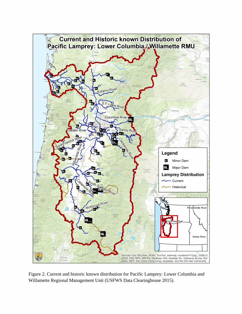
Figure 2. Current and historic known distribution for Pacific Lamprey: Lower Columbia and Willamette Regional Management Unit (USFWS Data Clearinghouse 2015).

Distribution and Connectivity Passage in the Willamette Sub- Unit is not impeded by dams of the Federal Columbia River Power System it is however affected by other dams including Dexter, Fall Creek, Fernridge, Stayton, Bennett, Big Cliff, Detroit, Minto, Lebanon, Foster, Faraday, North Fork, and Kellogg. Culverts and diversion dams for agriculture and municipal water sources are widespread throughout the watersheds of the Willamette. Flow alterations, dewatering, and floodplain disconnectivity associated with dams in this region are a significant impact to Pacific Lamprey distribution and connectivity.
Recent surveys have been conducted throughout the Willamette Sub-Unit to assess abundance and habitat requirements for Pacific Lamprey. Distribution of lamprey in the Willamette is strongly related to physical migration barriers. Adult migration barriers are the main contributing factor for larval distribution. Locations where larvae were not present were associated with migration barriers (often diversion dams) and suggest that habitat restoration strategies to increase complexity of stream channels will benefit Pacific Lamprey. Continued assessments of Pacific Lamprey throughout the Sub-Unit are needed to evaluate and prioritize actions necessary for recovery (Schultz et al. 2014). A number of recent studies have been conducted in the mainstem Willamette, Columbia and Snake rivers to document use by larval lamprey (Jolley et al. 2012; Jolley et al. 2014).
C. Threats
Summary of Major Treats The following table summarizes the known key threats within the Willamette Sub-Unit tributaries (H – High, M – Medium, L – Low, and U- Unknown). Passage and stream and floodplain degradation are the highest priority threats in the Willamette followed by dewatering and flow management and water quality. (Table 2, from Luzier et al. 2011)
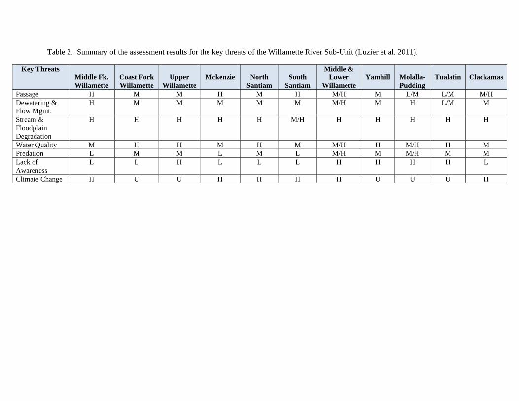
Table 2. Summary of the assessment results for the key threats of the Willamette River Sub-Unit (Luzier et al. 2011).
Key Threats Middle Fk. Willamette
Coast Fork Willamette
Upper
Willamette
Mckenzie
North
Santiam
South
Santiam
Middle & Lower
Willamette
Yamhill
Molalla-Pudding
Tualatin
Clackamas
Passage H M M H M H M/H M L/M L/M M/H Dewatering & Flow Mgmt.
H M M M M M M/H M H L/M M
Stream & Floodplain Degradation
H H H H H M/H H H H H H
Water Quality M H H M H M M/H H M/H H M Predation L M M L M L M/H M M/H M M Lack of Awareness
L L H L L L H H H H L
Climate Change H U U H H H H U U U H

New Threats The RMU met periodically during the Regional Implementation Planning process. Passage, stream and floodplain disconnectivity, and dewatering continue to be the major threats to Pacific Lamprey in the Willamette Sub-Unit. Predation and lack of awareness of Pacific Lamprey were identified as moderate to high threats in the Upper, Middle, and Lower Willamette, Yamhill, Molalla, and Tualatin watersheds.
Restoration Actions Within the Willamette Sub-Unit, ladder improvements by PGE at River Mill, Faraday, and North Fork Dams as well as the installation of ramps at River Mill and North Fork Dams have successfully increased adult lamprey passage on the Clackamas River.
Distribution and occupancy surveys have been completed in many of the watersheds including: Clear and Thomas Creeks, Calapooia and Luckiamute Rivers, Eagle Creek, Silver Creek at the Silverton Dam, Molalla River near Freyer Park, Scott Mills on Butte Creek, Milk Creek, Deep Creek, and the Little Luckiamute. Information collected through these surveys will guide conservation actions in the Willamette.
The Confederated Tribes of the Grand Ronde is conducting a translocation project at Fall Creek. 240 lamprey were trapped at Willamette Falls and translocated to Fall Creek in 2013 and 2014. Radio-telemetry is being used to identify pre-spawning mortality and distribution.
There are a number of restoration projects focused on connecting floodplains in the Middle Willamette being funded by Myer Memorial Trust. The RMU is continuing to coordinate with watershed councils on these projects.
A floodplain enhancement project is currently underway in lower Deer Creek, and major tributary to the Mackenzie River. The project will restore spawning and rearing habitat for Pacific Lamprey at a relatively large scale.
III. Selection of Priority Actions A. Prioritization Process The highest priority threat in the Willamette Sub-Unit is stream and floodplain degradation. Passage, dewatering and flow management, water quality and predation all ranked moderate to high for both scope and severity. Therefore the priorities focused on projects that addressed stream and floodplain degradation and uncertainties in Pacific Lamprey distribution.
Lack of awareness was ranked high for scope and severity for several watersheds and low in others depending on the type and amount of research or in-stream work that is being conducted. Disease and small population effects were ranked unknown for both scope and severity in all watersheds except for the lower Willamette in which they were ranked low. Climate change was ranked high in scope for some watersheds and unknown in both scope and severity for all other watersheds. Harvest/overutilization was ranked insignificant in some watersheds and unknown in others. Translocation was ranked not applicable. None of these threats were given an overall
average rank or prioritization even though the lower Willamette watershed did have ranks assigned for them.
Stream and Floodplain Degradation.—Overall, this threat was ranked high for scope and severity in most watersheds of the Willamette. Agriculture and urbanization have caused extensive channelization and loss of side channels and vegetation.
Water Quality.—Threats to water quality including elevated temperature, chemical, and sedimentation were generally ranked high or moderate in the Willamette. The McKenzie watershed was the only one to be ranked low. Temperature problems arise from flow fluctuations from water diversions. Urbanization and agricultural run-off are the main activities that contribute to poor water quality.
Other.—Of the smaller category threats lack of awareness was low in some watersheds and high in others for both scope and severity. Climate change was generally ranked high for scope throughout the Willamette but unknown for scope. Non-native fish and cormorants were cited as the most common predators on lampreys. The effects of disease and small population size are unknown in the Willamette. Harvest of adult lamprey in the lower Willamette has an unknown effect on the overall population in the Willamette.
B. HighPriorityProposedProjectInformation
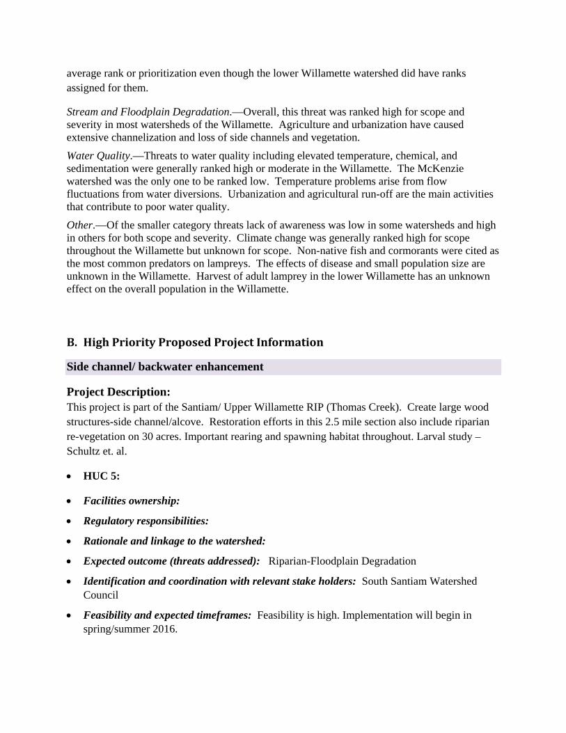
Side channel/ backwater enhancement
Project Description: This project is part of the Santiam/ Upper Willamette RIP (Thomas Creek). Create large wood structures-side channel/alcove. Restoration efforts in this 2.5 mile section also include riparian re-vegetation on 30 acres. Important rearing and spawning habitat throughout. Larval study – Schultz et. al.
HUC 5:
Facilities ownership:
Regulatory responsibilities:
Rationale and linkage to the watershed:
Expected outcome (threats addressed): Riparian-Floodplain Degradation
Identification and coordination with relevant stake holders: South Santiam Watershed Council
Feasibility and expected timeframes: Feasibility is high. Implementation will begin in spring/summer 2016.
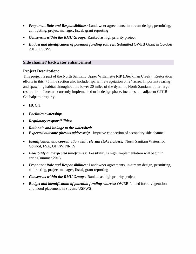
Proponent Role and Responsibilities: Landowner agreements, in-stream design, permitting, contracting, project manager, fiscal, grant reporting
Consensus within the RMU Groups: Ranked as high priority project.
Budget and identification of potential funding sources: Submitted OWEB Grant in October 2015; USFWS
Side channel/ backwater enhancement
Project Description: This project is part of the North Santiam/ Upper Willamette RIP (Dieckman Creek). Restoration efforts in this .75 mile section also include riparian re-vegetation on 24 acres. Important rearing and spawning habitat throughout the lower 20 miles of the dynamic North Santiam, other large restoration efforts are currently implemented or in design phase, includes the adjacent CTGR – Chahalpam property.
HUC 5:
Facilities ownership:
Regulatory responsibilities:
Rationale and linkage to the watershed: Expected outcome (threats addressed): Improve connection of secondary side channel
Identification and coordination with relevant stake holders: North Santiam Watershed Council, FSA, ODFW, NRCS
Feasibility and expected timeframes: Feasibility is high. Implementation will begin in spring/summer 2016.
Proponent Role and Responsibilities: Landowner agreements, in-stream design, permitting, contracting, project manager, fiscal, grant reporting
Consensus within the RMU Groups: Ranked as high priority project.
Budget and identification of potential funding sources: OWEB funded for re-vegetation and wood placement in-stream; USFWS

Side channel/ backwater enhancement
Project Description: This project is part of the South Santiam/ Upper Willamette RIP (Crabtree Creek). Create large wood structures-side channel/alcove. Restoration efforts in this dynamic 4 mile section also include riparian re-vegetation on 72 acres. Important rearing and spawning habitat throughout. Larval study – Schultz et. al. 2014.
HUC 5:
Facilities ownership:
Regulatory responsibilities:
Rationale and linkage to the watershed:
Expected outcome (threats addressed): Riparian-Floodplain Degradation
Identification and coordination with relevant stake holders: South Santiam Watershed Council
Feasibility and expected timeframes: Feasibility is high. Implementation will begin in spring/summer 2016.
Proponent Role and Responsibilities: Landowner agreements, in-stream design, permitting, contracting, project manager, fiscal, grant reporting
Consensus within the RMU Groups: Ranked as high priority project.
Budget and identification of potential funding sources: Submitted OWEB Grant in April 2015; USFWS
Improve Spawning and Rearing Habitat for Pacific Lamprey/Floodplain Enhancement
Project Description: This project is part of the McKenzie_Mid Fork_ Coast Fork Willamette RIP and will improve spawning and rearing habitat for Pacific Lamprey in the Lower South Fork McKenzie River. A large-scale project is underway to augment sediment and wood (3,000-4,000 pieces) on 4.5 miles of the South Fork McKenzie River below Cougar Dam. Additional project actions include approx. 40 acres of levee and riprap removal, channel reconstruction, approx. 400 acres of floodplain reconnection, and 5-10 miles of side channel reconnection.
HUC 5:
Facilities ownership:

Regulatory responsibilities: Project is managed by McKenzie Watershed Council and Willamette NF
Rationale and linkage to the watershed:
Expected outcome (threats addressed): Project would restore spawning and rearing habitat for Pacific Lamprey that is easily accessible below impassable dams
Identification and coordination with relevant stake holders: McKenzie Watershed Council and Willamette NF
Feasibility and expected timeframes: Feasibility is high. Implementation may begin in 2017.
Proponent Role and Responsibilities:
Consensus within the RMU Groups: Ranked as high priority project.
Budget and identification of potential funding sources:
Abundance and Distribution Survey
Project Description: This project includes conducting presence/absence surveys within the Yamhill basin to identify the current range, abundance and distribution of Pacific Lamprey within the Yamhill. Once the range is understood then it would be easier to identify specific limiting factors within the system and develop projects to address those factors.
HUC 5:
Facilities ownership:
Regulatory responsibilities: Project is managed by McKenzie Watershed Council and Willamette NF
Rationale and linkage to the watershed:
Expected outcome (threats addressed): Project would restore spawning and rearing habitat for Pacific Lamprey that is easily accessible below impassable dams
Identification and coordination with relevant stake holders: Confederated Tribes of the Grand Ronde
Feasibility and expected timeframes: Feasibility is high.
Proponent Role and Responsibilities:
Consensus within the RMU Groups: Ranked as high priority project.
Budget and identification of potential funding sources:

References
Jolley J.C., G.S. Silver, and T.A. Whitesel. 2012. Occupancy and Detection of Larval Pacific Lampreys and Lampetra spp. in a Large River: the Lower Willamette River. Transactions of the American Fisheries Society 141:2, 305-312. Jolley, J.C., G.S. Silver, J. J. Skalicky, and T.A. Whitesel. 2014. Evaluation of Larval Pacific Lamprey Rearing in Mainstem Areas of the Columbia and Snake Rivers Impacted by Dams U.S. Fish and Wildlife Service, Columbia River Fisheries Program Office, Vancouver, WA. 27 pp. http://www.fws.gov/columbiariver/publications.html Luzier, C.W., H.A. Schaller, J.K. Brostrom, C. Cook-Tabor, D.H. Goodman, R.D. Nelle, K. Ostrand and B. Streif. 2011. Pacific Lamprey (Entosphenus tridentatus) Assessment and Template for Conservation Measures. U.S. Fish and Wildlife Service, Portland, Oregon. 282 pp. http://www.fws.gov/columbiariver/publications.html Schultz, L., M.P. Mayfield, G.T. Sheoships, L.A. Wyss, B.J. Clemens, B. Chasco, and C.B. Schreck. 2014. The Distribution and Relative Abundance of Spawning and Larval Pacific Lamprey in the Willamette River Basin. Fianl Report to the Columbia Inter-Tribal Fish Commission for project years 2011-2014. CRITFC Contract number C13-1. BPA Contract number 60877. BPA Project number 2008-524-00.