pacific highway upgrade frederickton to eungai · to mitigate the access constraint, access road a...
TRANSCRIPT

Pacific Highway Upgrade FREDERICKTON TO EUNGAI
HYDROLOGICAL MITIGATION REPORT
Design Package FS000
Zone 00G General
Stage ISSUED FOR INFORMATION
Document Number F2E-00G-RPT-FS000-0003[A4]
Date 22 October 2013
Prepared by:

Project: Pacific Highway Upgrade Frederickton to Eungai Document Title: Hydrological Mitigation Report Document Number: F2E-00G-RPT-FS000-0003[A4]
Date: 22 October 2013 Page 3 of 32 S:\05_Design\05_04 Drainage\Mitigation Report\Consultation\F2E Hydrological Mitigation Report Draft 4\F2E-00G-RPT-FS000-0003[A4].docx
CONTENTS
1 INTRODUCTION ........................................................................................................................... 4
1.1 Project Approval ................................................................................................................................ 5
1.2 Conditions of Approval ...................................................................................................................... 5
2 HYDROLOGY .............................................................................................................................. 10
2.1 Predictions ....................................................................................................................................... 11
2.2 Property Survey ............................................................................................................................... 12
2.3 Effects.............................................................................................................................................. 12
3 MITIGATION MEASURES .......................................................................................................... 13
3.1 Acceptable Effects ........................................................................................................................... 13
3.2 Consultation ..................................................................................................................................... 13
3.3 Detailed Property Impacts ............................................................................................................... 14
3.4 Stock Evacuation ............................................................................................................................. 29
3.5 Protection Against Increased Velocity ............................................................................................. 30
3.6 Maintenance .................................................................................................................................... 30
4 CONCLUSIONS .......................................................................................................................... 31
5 REFERENCES ............................................................................................................................ 32
TABLES
Table 1-1 Kempsey to Eungai Project Conditions of Approvals associated with hydrological conditions .......... 5
Table 1-2 Kempsey to Eungai Statement of Commitments (Revised) associated with hydrological conditions. 8
Table 3-3 Summary of Consultation ................................................................................................................ 13
Table 4-4 Summary of F2E flood mitigations ................................................................................................... 31
FIGURES
Figure 2-1 F2E project extent and location ....................................................................................................... 10
APPENDICES
Appendix A
Appendix B
Appendix C
Appendix D
Appendix E
Frederickton to Eungai Bypass Impacts – Overall Project Flood Impact 100 Years ARI
Frederickton to Eungai Bypass Impacts - Property Impacts
Frederickton to Eungai Bypass Impacts - Stock Evacuation Routes
Frederickton to Eungai Bypass Impacts - Department of Planning & Infrastructure
Frederickton to Eungai Bypass Impacts – Correspondence and other consultation details

Project: Pacific Highway Upgrade Frederickton to Eungai Document Title: Hydrological Mitigation Report Document Number: F2E-00G-RPT-FS000-0003[A4]
Page 4 of 32 Date: 22 October 2013 S:\05_Design\05_04 Drainage\Mitigation Report\Consultation\F2E Hydrological Mitigation Report Draft 4\F2E-00G-RPT-FS000-0003[A4].docx
1 INTRODUCTION
The NSW Roads and Maritime Services (RMS) are upgrading the Pacific Highway on the Mid North Coast of
NSW between Kempsey and Eungai. The Kempsey to Eungai Pacific Highway upgrade project comprises
approximately 41 kilometres of dual carriageway road that would bypass the towns of Kempsey and
Frederickton. As described in the Kempsey to Eungai Pacific Highway Upgrade Project Staging Report, the
project is being delivered in stages with Stage 1 consisting of the 14.5 kilometre bypass of Kempsey and
Frederickton, and Stage 2 consisting of the remaining 26 kilometres of dual carriageway between
Frederickton and Eungai. Construction of Stage 2 of the Kempsey to Eungai project commenced in
September 2013.
Roads and Maritime Services completed an environmental assessment of the Kempsey to Eungai upgrade
project (the Project EA) in 2007. The Project EA identified a range of environmental, social and planning
issues associated with the construction and operation of the Kempsey to Eungai upgrade and proposed
measures to mitigate or manage those potential impacts.
The Project EA was publicly exhibited in August 2007 for a period of 30 days. Following public exhibition,
submissions from stakeholders were received and addressed by RMS in the Submissions Report which was
lodged with the Director-General in March 2008.
After consideration of the Project EA and Submissions Report, the Minister for Planning approved the
Kempsey to Eungai Pacific Highway upgrade under part 75J of the Environmental Planning and Assessment
Act 1979 (EP&A Act) on 10 July 2008 subject to the Minister’s Conditions of Approval (CoA) being met.
These conditions were subsequently modified on 12 March 2010, 26 November 2010 and 10 January 2012.
The approved route for the Frederickton to Eungai section of the Pacific Highway Upgrade is to the west of
the existing Pacific Highway between Frederickton and Eungai Rail and passes through the lower Macleay
water catchment area. The Collombatti floodplain and Doughboy Swamp are two wetland areas that the road
will intersect. The area has a history of flooding which was considered during the detailed Environmental
Assessment for the Kempsey to Eungai Pacific Highway upgrade Project.
As a condition of approval consent for the Kempsey to Eungai Project, RMS is required to provide
reasonable and feasible flood mitigation measures for all properties where flood impacts are predicted to
increase as a result of the Project. Flood mitigation measures along the Frederickton to Eungai section of the
Project are minimal and relate to maintaining stock refuge and replacing the emergency stock evacuation
route to the North of Collombatti Creek. Negotiations have been undertaken with Landowners to provide
livestock safety refuge. This report details how the conditions of approval have been met, through a process
of consultation with landowners, Environment Protection Authority (EPA), State Emergency Services (SES)
and Kempsey Shire Council, the detailing the agreed compensatory works that are to be put in place.
Planning for movement of stock in flood events has been undertaken with landowners during property
acquisition negotiations and specifically addresses Conditions of Approval: 2.2, 2.4, 2.5 (a-d, f-g), 2.6 and
Statements of Commitments: C5, HF1, HF2, HF3, HF4, HF5. Stock movement across, under and over the
alignment during flood events will be addressed in in the flood emergency evacuation section 3.4 of this
report plan including provisions for livestock to be moved from Raymonds Lane to Mill Lane.
The Kempsey Bypass Hydrological Mitigation Report June 2010 provides the reasonable and feasible
mitigation measures RMS implemented in consultation with landowners for Stage 1 of the Kempsey to
Eungai Project. The flood modelling based on Stage 2 of the project shows no impact to farm infrastructure
or residence and minimal impact to livestock movements. This report aims to address the Ministers
Conditions of Approval before commencement of construction and will include sections on the hydrological
predictions, the movement of livestock during the construction and operation phases of the project and the
replacement evacuation route.

Project: Pacific Highway Upgrade Frederickton to Eungai Document Title: Hydrological Mitigation Report Document Number: F2E-00G-RPT-FS000-0003[A4]
Date: 22 October 2013 Page 5 of 32 S:\05_Design\05_04 Drainage\Mitigation Report\Consultation\F2E Hydrological Mitigation Report Draft 4\F2E-00G-RPT-FS000-0003[A4].docx
1.1 PROJECT APPROVAL
The Kempsey to Eungai Environment Assessment identified that flooding could affect properties through the
modification of the value of agricultural land, the ability for stock to find refuge and emergency accesses.
The proposed F2E upgrade crosses a number of ridges in the western half of the Collombatti precinct.
These ridges, which extend into flood-prone land, are used by graziers for stock refuge during floods.
Individual property owners were consulted during the EA as to their requirements for stock refuge. The
proposed alignment was designed to accommodate these requirements, and does not affect the ability of
stock to reach high ground during floods, resulting in no mitigations measures required.
Access for stock, including emergency access during flood to agricultural land, was considered in
consultation with landholders. Farm access underpasses have been provided at specific locations along the
highway to allow stock, machinery and farm vehicles to pass underneath the road. These have been
combined with fauna underpasses and waterway crossings in relevant locations. In particular, Raymonds
Lane (east) will be closed at the proposed upgrade, which is currently used as a route for stock from the
floodplain, especially during floods. To mitigate the access constraint, Access Road A will link Raymonds
Lane (east) and Seashore Lane (south) to Mill Lane overbridge, providing access to higher ground.
In addition, individual farm and stock accesses are provided within under the large cross drainage bridges
(Collombatti Creek BR003, Collombatti Overflow BR006, Clybucca Creek BR008 and Johnsons
CreekBR012), as well as at the Wizzenbucca Creek crossing.
At the northern end of the project, in the Barraganyatti and Eungai Rail precinct, where the alignment
traverses undulating terrain, the Environment Assessment did not identify any impacts associated with
flooding conditions.
1.2 CONDITIONS OF APPROVAL
This report addresses several of the Conditions of Approval (CoA) and Statements of Commitments (SoC)
for the Project associated with hydrological conditions. Table 1-1Table 1-1 Table 1-1 Table 1-1 and Table 1-
2Table 1-2 Table 1-2 Table 1-2 details the relevant clauses to comply with and identifies where in this
document, the compliance is demonstrated.
Table 1-1 Kempsey to Eungai Project Conditions of Approvals associated with hydrological conditions
Condition of Approval (CoA) Response reference
2.1
The Proponent shall subsidise any new or necessary update(s) to the relevant Kempsey Shire Council, Nambucca Shire Council and State Emergency Service plans and documents to reflect changes in flooding levels, flows and characteristics as a result of the project.
Kempsey Shire Council, Nambucca Shire Council and the State Emergency Services will be provided with the hydrological mitigation report, detailed design drawings of the stock evacuation route and the flood modeling undertaken by WMA Water and Thiess.

Project: Pacific Highway Upgrade Frederickton to Eungai Document Title: Hydrological Mitigation Report Document Number: F2E-00G-RPT-FS000-0003[A4]
Page 6 of 32 Date: 22 October 2013 S:\05_Design\05_04 Drainage\Mitigation Report\Consultation\F2E Hydrological Mitigation Report Draft 4\F2E-00G-RPT-FS000-0003[A4].docx
Condition of Approval (CoA) Response reference
2.2
The Proponent shall undertake further flood modeling during detailed design to ensure that the project is designed and constructed with the aim of not exceeding the afflux and flood-flow velocity performance criteria specified for the Macleay River Floodplain in Section 10 of the Kempsey to Eungai – Upgrading the Pacific Highway: Environmental Assessment and Section 2.2.8 of the Kempsey to Eungai – Upgrading the Pacific Highway: Submissions Report, referred to in condition 1.1 of this approval.
Flood modeling has been undertaken during detailed design and shows that the aim of not exceeding the afflux and the flood-flow velocity performance criteria has been met. Refer references in Section 2 of this hydrological mitigation report.
2.3
Should modeling required by condition 2.2 identify changes to drainage patterns along the existing Pacific Highway that are directly attributable to the project, the Proponent shall alter or install drainage structures on the existing Pacific Highway to preserve or maintain current hydrological flow paths and flood regimes upstream of the existing highway.
Modeling of the proposed detailed design shows no change in any drainage patterns along the existing Pacific Highway. Based on the modeling results the existing Pacific Highway will not require additional drainage structures.
2.4
The Proponent shall employ a suitably qualified and experienced independent hydrological engineer approved by the Director-General prior to commencement of construction to assist affected property owners in negotiating reasonable and feasible mitigation measures.
The Director General approved Mr Terry McKeown as the independent hydrological engineer on 22/10/2010 for the duration of the Kempsey to Eungai Project. Mr McKeown is available should any future design refinements affect property owners.
2.5
Prior to commencement of construction, the Proponent shall submit a hydrological mitigation report to the Department detailing all reasonable and feasible flood mitigation measures for all properties where flood impacts are predicted to increase as a result of the project. The report shall:
This report details the mitigation measures for Stage 2 of the Kempsey to Eungai Pacific Highway upgrade project. The Stage 1 Kempsey Hydrological Mitigation Report was submitted to DoPI June 2010 in accordance with MCoA.
2.5a
identify all properties likely to have an increased flooding impact and detail the predicted increased flooding impact;
During Stage 1 the properties were identified and the predicted flooding impacts were mitigated through negotiations with property owners. These works have now concluded on Stage 1 and were captured in the Kempsey Hydrological Mitigation Report.
Flood modeling for Stage 2 of the Project indicates minimal impact on rural properties and cattle movement during flood events.
2.5b
identify the at residence and/or general property protection measures to be employed to mitigate the predicted increases flooding impact;
During Stage 1 the properties were identified and the predicted flooding impacts were mitigated through negotiations with property owners. These works have now concluded on Stage 1 and were captured in the Kempsey Hydrological Mitigation Report.
Flood modeling for Stage 2 of the Project indicates minimal impact on rural properties and cattle movement during flood events.
During property negotiations some affected landowners were given access to parcels of elevated land to allow stock movements onto higher ground.

Project: Pacific Highway Upgrade Frederickton to Eungai Document Title: Hydrological Mitigation Report Document Number: F2E-00G-RPT-FS000-0003[A4]
Date: 22 October 2013 Page 7 of 32 S:\05_Design\05_04 Drainage\Mitigation Report\Consultation\F2E Hydrological Mitigation Report Draft 4\F2E-00G-RPT-FS000-0003[A4].docx
Condition of Approval (CoA) Response reference
2.5c
identify measures to be employed for directly impacted commercial/agricultural properties to assist in the protection or critical farm infrastructure and evacuation of stock during flood events;
During Stage 1 the properties were identified and the predicted flooding impacts were mitigated through negotiations with property owners. These works have now concluded on Stage 1 and were captured in the Kempsey Hydrological Mitigation Report.
Flood modeling for Stage 2 of the Project indicates minimal impact on rural properties and cattle movement during flood events.
During property negotiations some landowners were given access to parcels of elevated land to allow stock movements onto higher ground. During the construction period landowners will be progressively consulted on stock evacuation routes across/under/over the alignment and given access to evacuate stock as required.
2.5d
identify measures to be implemented to minimize scour and dissipate energy at locations where flood velocities are predicted to increase as a result of the project and cause localised soil erosion and/or pasture damage;
Section 3.5
2.5e
detail construction methods and landscaping treatments for the Frederickton levee;
The Frederickton Levee has been constructed and landscaped. These works have now concluded on Stage 1 and were captured in the Kempsey Hydrological Mitigation Report.
2.5f
be developed in consultation with the relevant branches of Kempsey Shire Council, DECC, State Emergency Service and directly-affected property owners; and
Consultation is now in progress with Kempsey Shire Council, Environment Protection Authority and the State Emergency Services. Consultation has been ongoing with property owners and will continue during the construction phase to assist in implementing a seamless flood evacuation plan for livestock.
2.5g
identify operational and maintenance responsibilities for items a) to e) inclusive.
The Proponent shall not commence construction of the project on or within areas likely to alter flood conditions on the Macleay River floodplain until such time as works identified in the hydrological mitigation report have been completed unless otherwise agreed by the Director-General.
During Stage 1 the properties were identified and the predicted flooding impacts were mitigated through negotiations with property owners. These works have now concluded on Stage 1 and were captured in the Kempsey Hydrological Mitigation Report.
Flood modeling for Stage 2 of the Project indicates minimal impact on rural properties and cattle movement during flood events.
During property negotiations some landowners were given access to parcels of elevated land to allow stock movements onto higher ground. During the construction period landowners will be progressively consulted on stock evacuation routes across/under/over the alignment, and given access to evacuate stock as required.
An emergency flood evacuation plan is being developed by Thiess and consultation is underway with stakeholders on the emergency access route and stock movements during flood events.

Project: Pacific Highway Upgrade Frederickton to Eungai Document Title: Hydrological Mitigation Report Document Number: F2E-00G-RPT-FS000-0003[A4]
Page 8 of 32 Date: 22 October 2013 S:\05_Design\05_04 Drainage\Mitigation Report\Consultation\F2E Hydrological Mitigation Report Draft 4\F2E-00G-RPT-FS000-0003[A4].docx
Condition of Approval (CoA) Response reference
2.6
The Proponent shall prepare a schedule of flood mitigation measures for each directly-affected property in consultation with the property owner. The schedule shall be provided to the relevant property owner(s) no later than two months prior to the implementation of the mitigation works, unless others agreed by the Director-General. A copy of each schedule of flood mitigation measures shall be provided to Council and the Department prior to the implementation / construction of the mitigation measures on the property.
During Stage 1 the properties were identified and the predicted flooding impacts were mitigated through negotiations with property owners. These works have now concluded on Stage 1 and were captured in the Kempsey Hydrological Mitigation Report.
Flood modeling for Stage 2 of the Project indicates minimal impact on rural properties and cattle movement during flood events.
During property negotiations some landowners were given access to parcels of elevated land to allow stock movements onto higher ground. During the construction period landowners will be progressively consulted on stock evacuation routes across/under/over the alignment and given access to evacuate stock as required.
An emergency flood evacuation plan is being developed by Thiess and consultation is underway with stakeholders on the emergency access route and stock movements during flood events.
Kempsey Shire Council, Nambucca Shire Council and the State Emergency Services will be provided with the hydrological mitigation report, detailed design drawings of the stock evacuation route and the flood modeling undertaken by WMA Water and Thiess.
2.7
In the event that the Proponent and the relevant property owner cannot agree on reasonable and feasible flood mitigation measures to be applied to a property within one month of the first consultation on the measures (as required under condition 2.6), either party may refer the matter to the Director-General for resolution.
All measures for stock evacuation have been determined in consultation with property owners during the property acquisition process
Table 1-2 Kempsey to Eungai Statement of Commitments (Revised) associated with hydrological conditions
Condition of Approval (CoA) Response reference
C5
Property owners will be consulted about the implementation of mitigation measures that affect their property and any issues raised will be addressed where reasonable and feasible.
As per 2.7 above
HF1
Flood modeling will be undertaken during the detailed design phase to further refine the bridging, drainage structure and flood mitigation requirements for the Macleay River and Collombatti Creek floodplains.
Frederickton to Eungai Bypass Impacts – Collombatti Creek March 2012 was completed by WMA Water (Appendix A).
WMA Water completed a number of reports for the Kempsey Bypass that showed flood modeling on the Macleay River. These reports have been previously submitted to DoPI to show compliance with this SoC.

Project: Pacific Highway Upgrade Frederickton to Eungai Document Title: Hydrological Mitigation Report Document Number: F2E-00G-RPT-FS000-0003[A4]
Date: 22 October 2013 Page 9 of 32 S:\05_Design\05_04 Drainage\Mitigation Report\Consultation\F2E Hydrological Mitigation Report Draft 4\F2E-00G-RPT-FS000-0003[A4].docx
Condition of Approval (CoA) Response reference
HF2
Reasonable and feasible, property specific flood mitigation measures (e.g.: ring levees, scour protection, etc.) will be further developed and implemented for properties identified as flood affected by the Proposal (in Section 10.2.2 of the Environmental Assessment) in consultation with affected landholders.
All measures for stock evacuation have been determined in consultation with property owners during the property acquisition process
HF3
Where reasonable and feasible, houses identified as flood-affected by the Proposal (in Section 10.2.2 of the Environmental Assessment) will be raised so that the floor level is a minimum of 0.5m higher than the modeled 100 year ARI peak flood level. In consultation with affected landowners, alternative strategies to reduce damage during flooding would be developed and implemented for those premises that cannot be raised by the minimum required.
During Stage 1 the properties were identified and the predicted flooding impacts were mitigated through negotiations with property owners. These works have now concluded on Stage 1 and were captured in the Kempsey Hydrological Mitigation Report.
There are no houses identified in the Frederickton to Eungai section of the Kempsey to Eungai Project requiring mitigation.
HF4
Stock mounds, yards and truck loading facilities will be provided for affected landholders along South West Rocks Road to assist in the refuge and / or evacuation of stock during floods. The location of the facilities will be determined in consultation with the affected landowners.
South West Rocks Road were part of Stage 1 Kempsey to Eungai Project and the mitigation measures have been put in place in consultation with the landowners.
HF5
A levee and associated flood control devices will be constructed at Frederickton prior to the commencement of construction of the Proposal on the Macleay River floodplain.
The Frederickton Levee has been constructed and landscaped. These works have now concluded on Stage 1 and were captured in the Kempsey Hydrological Mitigation Report.
Project: Pacific Highway Upgrade Frederickton to Eungai Document Title: Hydrological Mitigation Report Document Number: F2E-00G-RPT-FS000-0003[A4]
Page 10 of 32 Date: 22 October 2013 S:\05_Design\05_04 Drainage\Mitigation Report\Consultation\F2E Hydrological Mitigation Report Draft 4\F2E-00G-RPT-FS000-0003[A4].docx
2 HYDROLOGY
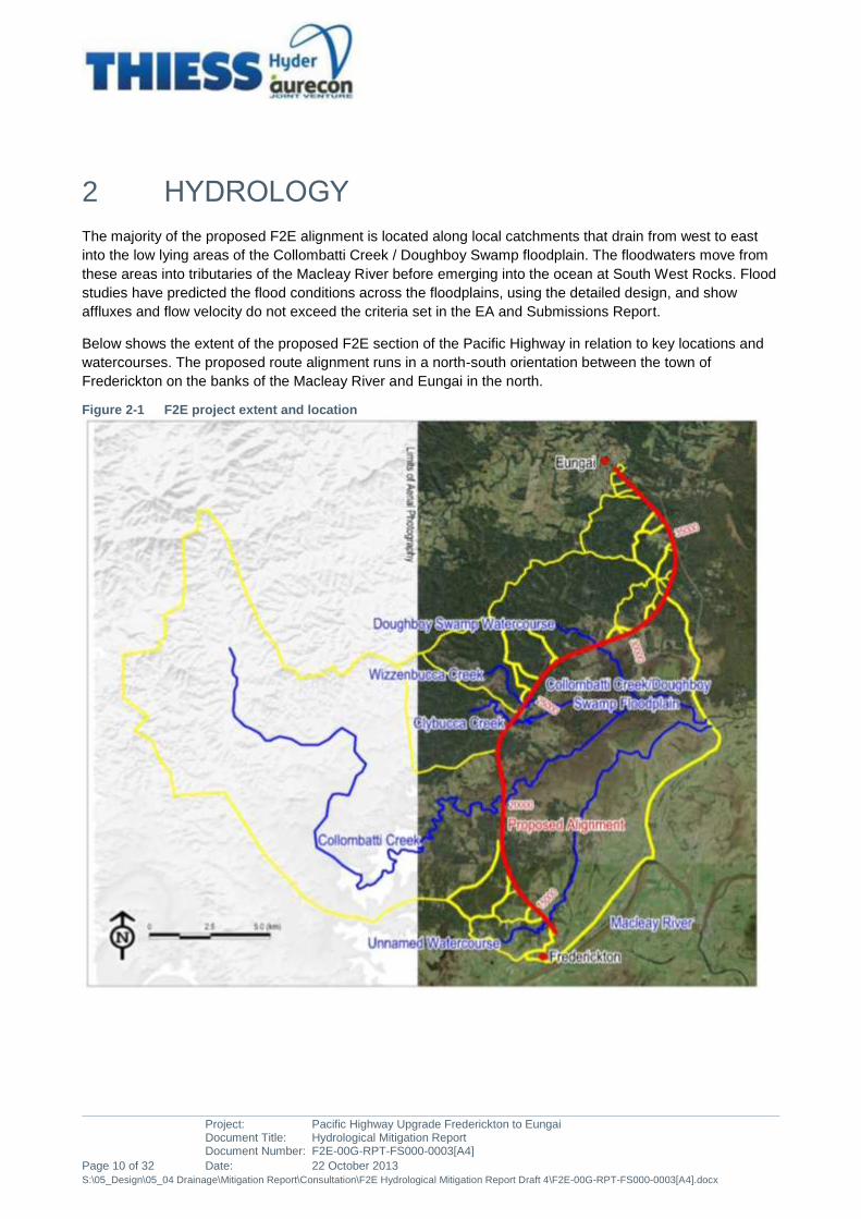
The majority of the proposed F2E alignment is located along local catchments that drain from west to east
into the low lying areas of the Collombatti Creek / Doughboy Swamp floodplain. The floodwaters move from
these areas into tributaries of the Macleay River before emerging into the ocean at South West Rocks. Flood
studies have predicted the flood conditions across the floodplains, using the detailed design, and show
affluxes and flow velocity do not exceed the criteria set in the EA and Submissions Report.
Below shows the extent of the proposed F2E section of the Pacific Highway in relation to key locations and
watercourses. The proposed route alignment runs in a north-south orientation between the town of
Frederickton on the banks of the Macleay River and Eungai in the north.
Figure 2-1 F2E project extent and location
Project: Pacific Highway Upgrade Frederickton to Eungai Document Title: Hydrological Mitigation Report Document Number: F2E-00G-RPT-FS000-0003[A4]
Date: 22 October 2013 Page 11 of 32 S:\05_Design\05_04 Drainage\Mitigation Report\Consultation\F2E Hydrological Mitigation Report Draft 4\F2E-00G-RPT-FS000-0003[A4].docx
1. Two flooding mechanisms can affect the Collombatti Creek / Doughboy Swamp floodplain:
Macleay River flooding: the floodplain can be inundated by rising Macleay River water levels, the
inundation levels are controlled by the Macleay River, and the draining of the floodwaters can only
occur after the Macleay River water levels have receded. This regional flood mechanism affects the
Collombatti Creek / Doughboy Swamp floodplain, and is currently the most constraining flooding
mechanism along the lower sections of the proposed F2E Pacific Highway. The Macleay River
flooding conditions have been comprehensively studied by WMA Water as part of the Environmental
Assessment (EA) and the EA Concept Design.
Local catchment flooding: the runoff from the local catchments located west of the F2E alignment
flows directly into the Collombatti Creek / Doughboy Swamp floodplain at several locations. Whilst the
inflows to the floodplain are spatially disconnected, the runoff accumulates in the floodplain, where its
vast flat low-lying areas and the downstream gates attenuate the downstream conveyance of flood
flows. As a result, water levels in the floodplain slowly rise and create a hydraulic connection between
the floodplain inflows. Where the F2E alignment falls within the local catchment’s design flood
predicted extents, the proposed design is likely to affect local flooding conditions, which effects have
been comprehensively studied by Hyder Aurecon Joint Venture (HAJV) as part of the project’s detailed
design.
2. The studies by WMA Water (2012) and HAJV (2013) utilised a suite of computer based
mathematical models to simulate flooding in the areas crossed by the F2E alignment. These models
were reviewed and their accuracy in simulating flood flows confirmed. They were utilised to replicate
the proposed highway and structures and indicate the impact the road would have on flood
behaviour.
2.1 PREDICTIONS
As part of the design, hydrologic and hydraulic modelling has been undertaken at all the watercourses that
are crossed by the project works to determine flooding and associated impacts. Two types of hydraulic
modelling were applied depending on the influence of floodplains and downstream hydraulic controls:
1D steady state HEC-RAS modelling, for all crossings located outside of floodplains connected to
Clybucca Creek at Clybucca. The associated watercourses are independent from each other at the
crossings and the design flow conditions are controlled by the local channel geometry.
2D hydro-dynamic TUFLOW modelling, for the crossings located in the floodplains connected to
Clybucca Creek at Clybucca. The local catchments of Collombatti Creek, Clybucca Creek,
Wizzenbucca Creek and Doughboy Swamp all converge into a large flood storage area currently
enclosed by the Pacific Highway embankment and regulated by flood gates and the water levels in the
downstream Macleay River. F2E-00G-RPT-FS000-0001[B2] (HAJV, 2013) and Frederickton to
Eungai Bypass Impacts – Collombatti Creek (WMA Water, 2012).
Details of these two hydrological models is presented in Appendix B and provide the details and impacts of
the Local catchment and the Macleay River catchment overlaid on the region, together with the impacts
where the project has increased local afflux levels.

Project: Pacific Highway Upgrade Frederickton to Eungai Document Title: Hydrological Mitigation Report Document Number: F2E-00G-RPT-FS000-0003[A4]
Page 12 of 32 Date: 22 October 2013 S:\05_Design\05_04 Drainage\Mitigation Report\Consultation\F2E Hydrological Mitigation Report Draft 4\F2E-00G-RPT-FS000-0003[A4].docx
2.2 PROPERTY SURVEY
An overall initial property survey has been undertaken of the properties within the project including the
Macleay River, Collombatti and Doughboy Swamp floodplains together with local catchments. Currently, as
determined by the hydraulic modelling, there is no residence affected by flood inundation on these properties
and only isolated areas of farm land impacted.
A complete property survey and all impacts is provided in Appendix A
2.3 EFFECTS
The land affected by flooding is a mix of private agricultural lands and State Forests. The proposed design
does not generate tangible damage, or compromise any of the property’s functionality and usage that would
not have otherwise been affected during Macleay River flood events. There is some minor isolated afflux
impacts during the critical 100yr peak predicted flood levels but the main impact are not affected by the F2E
design even is due to the influence of the Macleay River. There is some other isolated minor impact due to
local catchment in the north of the project.
Details of the effected properties and the impacts are provided in Appendix B.

Project: Pacific Highway Upgrade Frederickton to Eungai Document Title: Hydrological Mitigation Report Document Number: F2E-00G-RPT-FS000-0003[A4]
Date: 22 October 2013 Page 13 of 32 S:\05_Design\05_04 Drainage\Mitigation Report\Consultation\F2E Hydrological Mitigation Report Draft 4\F2E-00G-RPT-FS000-0003[A4].docx
3 MITIGATION MEASURES
3.1 ACCEPTABLE EFFECTS
In the areas influenced by the backwater inundation from Collombatti floodplain and Doughboy Swamp and
other Local catchments, the impact on flood conditions and nearby properties are considered minimal,
reasonable and compliant where:
• Flood Planning Levels (FPLs) based on the most critical 1% Annual Exceedence Probability (AEP)
flood conditions, as defined by the NSW Floodplain Development Manual, are not affected; and where
• The design does not:
Increase inundation duration along flow path,
Increase tangible damages,
Prevent main access and egress to properties, or
Prevent the continuation of all on-going property activities, in properties where access and egress,
functionality and property usage would not be fully or partially compromised at the peak of identical
hydrologic conditions under existing pre F2E development conditions, during a 1% AEP design flood.
It is accepted that the construction of the highway upgrade will inevitably create afflux from local catchment
conditions. For the avoidance of doubt, the resulting local catchment peak flood levels for events up and
including the 1% AEP flood, will not exceed the existing controlling regional 100 year ARI Macleay River
peak flood level within the area of influence of the afflux.
3.2 CONSULTATION
Consultation has been undertaken of all properties affected outside of the Macleay River impacts. The table
below provides the details of these consultations:
Table 3-3 Summary of Consultation
Reference Owner Date of Consultation Type of Consultation
ID 14 TAYLOR D.M. & K.J. 1st
October 2013 Face to face meeting
ID 15 ROSSITER, W.J & J.A 3rd
October 2013 Face to face meeting
ID 74 NSW FORESTRY 27th
September 2013 Correspondence Ref App E
ID75 RMS( Land back to Forestry) 27th
September 2013 Correspondence Ref App E
ID 79 STYLES A.J 2nd
October 2013 Face to face meeting
ID 80 SCARFID( STYLES) 2nd
October 2013 Face to face meeting
ID 81 CROSS C.C & T.M 2nd
October 2013 Face to face meeting
ID 82 FERGUSON 22nd
October 2013 Correspondence Ref App E
ID 83 RMS( Land back to Forestry) 27th
September 2013 Correspondence Ref App E

Project: Pacific Highway Upgrade Frederickton to Eungai Document Title: Hydrological Mitigation Report Document Number: F2E-00G-RPT-FS000-0003[A4]
Page 14 of 32 Date: 22 October 2013 S:\05_Design\05_04 Drainage\Mitigation Report\Consultation\F2E Hydrological Mitigation Report Draft 4\F2E-00G-RPT-FS000-0003[A4].docx
Reference Owner Date of Consultation Type of Consultation
ID 84 CRANE(NSW Forestry) 27th
September 2013 Correspondence Ref App E
Id 85 NSW FORESTRY 27th
September 2013 Correspondence Ref App E
Other consultations that have been undertaken:
Reference Owner Date of Consultation Type of Consultation
KEMPSEY COUNCIL 11th
October 2013 Face to face meeting
STATE EMERGENCY SERVICES
22nd
October 2013 Phone call discussion
3.3 DETAILED PROPERTY IMPACTS
The following section contains details of the specific impacts for each flood impacted property. Appendix B
depicts the location of the affected properties

Project: Pacific Highway Upgrade Frederickton to Eungai Document Title: Hydrological Mitigation Report Document Number: F2E-00G-RPT-FS000-0003[A4]
Date: 22 October 2013 Page 15 of 32 S:\05_Design\05_04 Drainage\Mitigation Report\Consultation\F2E Hydrological Mitigation Report Draft 4\F2E-00G-RPT-FS000-0003[A4].docx
3.3.1 PROPERTY (ID14)
Owner Name: K &R Taylor
Lots/DP of affected lots covered on this sheet: DP 713220
Index of affected lots owned: Lot 206
Address/Location: 107 Raymonds Lane Frederickton
Business Type: Rural Residential
Existing House Floor Level: Approx 1m above Ground level
Ground Level: 22m AHD
Flood level: (at the locations of the works)
Event Boundary Flood
Level (m)
Afflux (m) Critical Storm
duration (hr)
100 years
CML103
5.42
0.86
1
Impact Category MINOR Rural lands in the
lower left corner of
land
100 year Current Road
Design
6.9
Discussions took place on: 1st October2013
Summary of Impact
No additional Impact above the Environmental Assessment
Flood Impact effected by the Macleay River flood management
Culvert sizes equal to EA
o CML 103 - 1x 1350mm RCP
Egress via Raymonds Land
Impact shown on maps is for the 1:100 yr( last storm event Feb 2013 was a 1:13Yr)
Smaller storms will have a smaller afflux impact
Issues Raised:
No concern with Flood impacts to property

Project: Pacific Highway Upgrade Frederickton to Eungai Document Title: Hydrological Mitigation Report Document Number: F2E-00G-RPT-FS000-0003[A4]
Page 16 of 32 Date: 22 October 2013 S:\05_Design\05_04 Drainage\Mitigation Report\Consultation\F2E Hydrological Mitigation Report Draft 4\F2E-00G-RPT-FS000-0003[A4].docx
3.3.2 PROPERTY (ID15)
Owner Name: ROSSITER, W.J & J.A
Lots/DP of affected lots covered on this sheet: DP 713220
Index of affected lots owned: Lot 205
Address/Location: Raymonds Lane Frederickton
Business Type: Rural Residential
Existing House Floor Level: Approx 1m above Ground level
Ground Level: 18m AHD
Flood level: (at the locations of the works)
Event Boundary Flood
Level (m)
Afflux (m) Critical Storm
duration (hr)
100 years
CML103
5.42
0.86
1
Impact Category MINOR Rural lands in the
lower left corner of
land
100 year Current Road
Design
6.9
Discussions took place on: 3rd Ooctober2013
Summary of Impact
• No additional Impact above the Environmental Assessment
• Flood Impact effected by the Macleay River flood management
• Culvert sizes equal to
o CML 103 - EA 1x 1350mm RCP
• Egress via Raymonds Land
• Impact shown on maps is for the 1:100 yr( last storm event Feb 2013 was a 1:13Yr)
Smaller storms will have a smaller afflux impact Issues Raised:
• No concern with Flood impacts to property

Project: Pacific Highway Upgrade Frederickton to Eungai Document Title: Hydrological Mitigation Report Document Number: F2E-00G-RPT-FS000-0003[A4]
Date: 22 October 2013 Page 17 of 32 S:\05_Design\05_04 Drainage\Mitigation Report\Consultation\F2E Hydrological Mitigation Report Draft 4\F2E-00G-RPT-FS000-0003[A4].docx
3.3.3 PROPERTY (ID72)
Owner Name: NSW Forestry
Lots/DP of affected lots covered on this sheet: DP 1022011
Index of affected lots owned: Lot 1
Address/Location: NA
Business Type: Forestry
Existing House Floor Level: NA
Ground Level: NA
Flood level: (at the locations of the works)
Event Boundary Flood
Level (m)
Afflux (m) Critical Storm
duration (hr)
100 years
CML 305
9.36
0.76
1
Impact Category MINOR Afflux dissipates
within Forestry
Land and within the
50m exclusion
Zone
100 year Current Road
Design
12.235
Discussions took place on: Correspondence issued 27th September 2013
Response: Refer App E
Summary of Impact
No additional Impact above the Environmental Assessment
Flood Impact effected by the local catchment only
Culvert sizes greater than EA
o CML0 305 - 1x 2400x2400mm RCBC
Egress via Forestry Tracks to the west
Impact shown on maps is for the 1:100 yr( last storm event Feb 2013 was a 1:13Yr)
Smaller storms will have a smaller afflux impact
Issues Raised:
Nil issues raised

Project: Pacific Highway Upgrade Frederickton to Eungai Document Title: Hydrological Mitigation Report Document Number: F2E-00G-RPT-FS000-0003[A4]
Page 18 of 32 Date: 22 October 2013 S:\05_Design\05_04 Drainage\Mitigation Report\Consultation\F2E Hydrological Mitigation Report Draft 4\F2E-00G-RPT-FS000-0003[A4].docx
3.3.4 PROPERTY (ID74)
Owner Name: NSW Forestry
Lots/DP of affected lots covered on this sheet: DP 752403
Index of affected lots owned: Lot 57
Address/Location: NA
Business Type: Forestry
Existing House Floor Level: NA
Ground Level: NA
Flood level: (at the locations of the works)
Event Boundary Flood
Level (m)
Afflux
(m)
Critical Storm
duration (hr)
100 years
CML305
CML 306
9.36
13.82
0.76
1.92
1
Impact Category MINOR Afflux dissipates
within Forestry
Land and within the
50m exclusion
Zone
100 year Current Road
Design
CML305
CML 306
12.235
15.600
Discussions took place on: Correspondence issued 27/9/13
Response: Refer App E
Summary of Impact
No additional Impact above the Environmental Assessment
Flood Impact effected by the local catchment only
Culvert sizes equal to EA
o CML 306 - 1x 2400x2400mm RCBC
Egress via Forestry Tracks to the west
Project: Pacific Highway Upgrade Frederickton to Eungai Document Title: Hydrological Mitigation Report Document Number: F2E-00G-RPT-FS000-0003[A4]
Date: 22 October 2013 Page 19 of 32 S:\05_Design\05_04 Drainage\Mitigation Report\Consultation\F2E Hydrological Mitigation Report Draft 4\F2E-00G-RPT-FS000-0003[A4].docx
Impact shown on maps is for the 1:100 yr( last storm event Feb 2013 was a 1:13Yr)
Smaller storms will have a smaller afflux impact
Issues Raised:
Nil issues raised
Project: Pacific Highway Upgrade Frederickton to Eungai Document Title: Hydrological Mitigation Report Document Number: F2E-00G-RPT-FS000-0003[A4]
Page 20 of 32 Date: 22 October 2013 S:\05_Design\05_04 Drainage\Mitigation Report\Consultation\F2E Hydrological Mitigation Report Draft 4\F2E-00G-RPT-FS000-0003[A4].docx
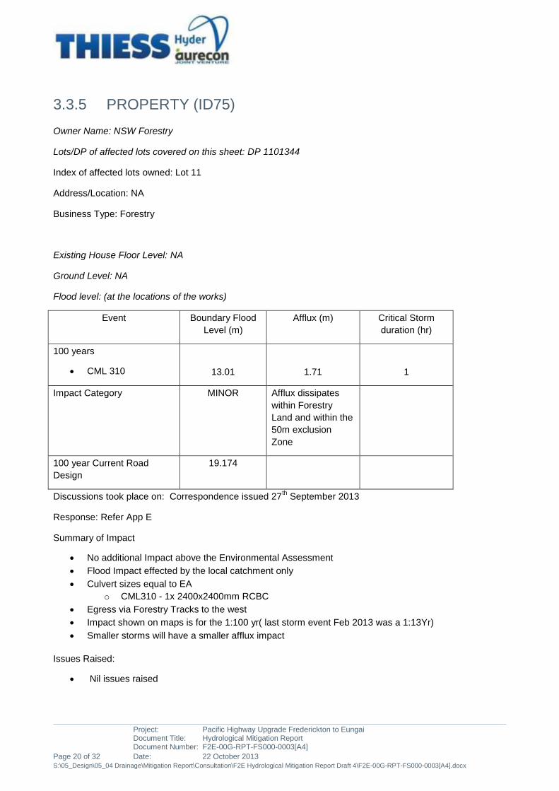
3.3.5 PROPERTY (ID75)
Owner Name: NSW Forestry
Lots/DP of affected lots covered on this sheet: DP 1101344
Index of affected lots owned: Lot 11
Address/Location: NA
Business Type: Forestry
Existing House Floor Level: NA
Ground Level: NA
Flood level: (at the locations of the works)
Event Boundary Flood
Level (m)
Afflux (m) Critical Storm
duration (hr)
100 years
CML 310
13.01
1.71
1
Impact Category MINOR Afflux dissipates
within Forestry
Land and within the
50m exclusion
Zone
100 year Current Road
Design
19.174
Discussions took place on: Correspondence issued 27th September 2013
Response: Refer App E
Summary of Impact
No additional Impact above the Environmental Assessment
Flood Impact effected by the local catchment only
Culvert sizes equal to EA
o CML310 - 1x 2400x2400mm RCBC
Egress via Forestry Tracks to the west
Impact shown on maps is for the 1:100 yr( last storm event Feb 2013 was a 1:13Yr)
Smaller storms will have a smaller afflux impact
Issues Raised:
Nil issues raised
Project: Pacific Highway Upgrade Frederickton to Eungai Document Title: Hydrological Mitigation Report Document Number: F2E-00G-RPT-FS000-0003[A4]
Date: 22 October 2013 Page 21 of 32 S:\05_Design\05_04 Drainage\Mitigation Report\Consultation\F2E Hydrological Mitigation Report Draft 4\F2E-00G-RPT-FS000-0003[A4].docx
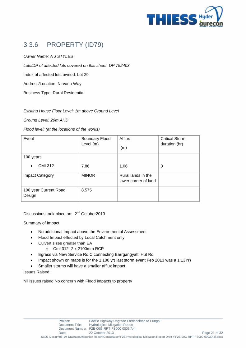
3.3.6 PROPERTY (ID79)
Owner Name: A J STYLES
Lots/DP of affected lots covered on this sheet: DP 752403
Index of affected lots owned: Lot 29
Address/Location: Nirvana Way
Business Type: Rural Residential
Existing House Floor Level: 1m above Ground Level
Ground Level: 20m AHD
Flood level: (at the locations of the works)
Event Boundary Flood
Level (m)
Afflux
(m)
Critical Storm
duration (hr)
100 years
CML312
7.86
1.06
3
Impact Category MINOR Rural lands in the
lower corner of land
100 year Current Road
Design
8.575
Discussions took place on: 2nd
October2013
Summary of Impact
No additional Impact above the Environmental Assessment
Flood Impact effected by Local Catchment only
Culvert sizes greater than EA
o Cml 312- 2 x 2100mm RCP
Egress via New Service Rd C connecting Barrgangyatti Hut Rd
Impact shown on maps is for the 1:100 yr( last storm event Feb 2013 was a 1:13Yr)
Smaller storms will have a smaller afflux impact
Issues Raised:
Nil issues raised No concern with Flood impacts to property
Project: Pacific Highway Upgrade Frederickton to Eungai Document Title: Hydrological Mitigation Report Document Number: F2E-00G-RPT-FS000-0003[A4]
Page 22 of 32 Date: 22 October 2013 S:\05_Design\05_04 Drainage\Mitigation Report\Consultation\F2E Hydrological Mitigation Report Draft 4\F2E-00G-RPT-FS000-0003[A4].docx
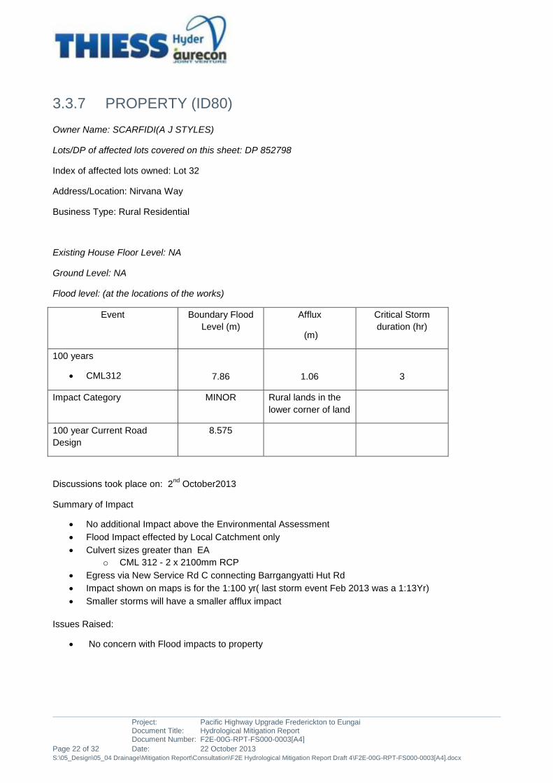
3.3.7 PROPERTY (ID80)
Owner Name: SCARFIDI(A J STYLES)
Lots/DP of affected lots covered on this sheet: DP 852798
Index of affected lots owned: Lot 32
Address/Location: Nirvana Way
Business Type: Rural Residential
Existing House Floor Level: NA
Ground Level: NA
Flood level: (at the locations of the works)
Event Boundary Flood
Level (m)
Afflux
(m)
Critical Storm
duration (hr)
100 years
CML312
7.86
1.06
3
Impact Category MINOR Rural lands in the
lower corner of land
100 year Current Road
Design
8.575
Discussions took place on: 2nd
October2013
Summary of Impact
No additional Impact above the Environmental Assessment
Flood Impact effected by Local Catchment only
Culvert sizes greater than EA
o CML 312 - 2 x 2100mm RCP
Egress via New Service Rd C connecting Barrgangyatti Hut Rd
Impact shown on maps is for the 1:100 yr( last storm event Feb 2013 was a 1:13Yr)
Smaller storms will have a smaller afflux impact
Issues Raised:
No concern with Flood impacts to property

Project: Pacific Highway Upgrade Frederickton to Eungai Document Title: Hydrological Mitigation Report Document Number: F2E-00G-RPT-FS000-0003[A4]
Date: 22 October 2013 Page 23 of 32 S:\05_Design\05_04 Drainage\Mitigation Report\Consultation\F2E Hydrological Mitigation Report Draft 4\F2E-00G-RPT-FS000-0003[A4].docx
3.3.8 PROPERTY (ID81)
Owner Name: CROSS, C.C &T.M
Lots/DP of affected lots covered on this sheet: DP 829401
Index of affected lots: 22
Address/Location: Barrgangyatti Hut Rd
Business Type: Rural Residential
Existing House Floor Level: 1m above Ground Level
Ground Level: 20m AHD
Flood level: (at the locations of the works)
Event Boundary Flood
Level (m)
Afflux
(m)
Critical Storm
duration (hr)
100 years
CML 313
8.37
1.88
2
Impact Category MINOR Rural lands in the
upper corner of
land
100 year Current Road
Design
10.139
Discussions took place on: 2nd
October 2013
Summary of Impact
No additional Impact above the Environmental Assessment
Culvert sizes greater than EA
o CML 313 - 2 x 1200mm RCP
Egress via Barrgangyatti Hut Rd
Impact shown on maps is for the 1:100 yr( last storm event Feb 2013 was a 1:13Yr)
Smaller storms will have a smaller afflux impact
Issues Raised:
No concern with Flood impacts to property

Project: Pacific Highway Upgrade Frederickton to Eungai Document Title: Hydrological Mitigation Report Document Number: F2E-00G-RPT-FS000-0003[A4]
Page 24 of 32 Date: 22 October 2013 S:\05_Design\05_04 Drainage\Mitigation Report\Consultation\F2E Hydrological Mitigation Report Draft 4\F2E-00G-RPT-FS000-0003[A4].docx
3.3.9 PROPERTY (ID82)
Owner Name: FERGUSON
Lots/DP of affected lots covered on this sheet: DP 705912
Index of affected lots: 304
Address/Location: Barrgangyatti Hut Rd
Business Type: Rural Residential
Existing House Floor Level: 1m above Ground Level
Ground Level: 20m AHD
Flood level: (at the locations of the works)
Event Boundary Flood
Level (m)
Afflux
(m)
Critical Storm
duration (hr)
100 years
CML 313
8.37
1.88
2
Impact Category MINOR Rural lands in the
upper corner of
land
100 year Current Road
Design
10.139
Discussions took place on: Consultation Declined and letter sent 22nd
October 2013
Response: Verbal advise was received no concern with flood impacts
Summary of Impact
No additional Impact above the Environmental Assessment
Culvert sizes greater than EA
o CML 313 - 2 x 1200mm RCP
Egress via Barrgangyatti Hut Rd
Impact shown on maps is for the 1:100 yr( last storm event Feb 2013 was a 1:13Yr)
Smaller storms will have a smaller afflux impact
Issues Raised:
No concern with Flood impacts to property

Project: Pacific Highway Upgrade Frederickton to Eungai Document Title: Hydrological Mitigation Report Document Number: F2E-00G-RPT-FS000-0003[A4]
Date: 22 October 2013 Page 25 of 32 S:\05_Design\05_04 Drainage\Mitigation Report\Consultation\F2E Hydrological Mitigation Report Draft 4\F2E-00G-RPT-FS000-0003[A4].docx
3.3.10 PROPERTY (ID84)
Owner Name: NSW Forestry (Crane)
Lots/DP of affected lots covered on this sheet: DP 752403
Index of affected lots owned: Lot 48/68
Address/Location: NA
Business Type: Forestry
Existing House Floor Level: NA
Ground Level: NA
Flood level: (at the locations of the works)
Event Boundary Flood
Level (m)
Afflux (m) Critical Storm
duration (hr)
100 years
CML314
CML315
CML316
6.38
10.41
12.36
0.29
0.51
0.66
4
1
1
Impact Category MINOR Afflux dissipates
within Forestry
Land and within the
50m exclusion
Zone
100 year Current Road
Design
CML 315
CML316
11.555
15.170
Discussions took place on: Correspondence issued 27th September 2013
Response: refer App E (Awaiting Response)
Summary of Impact
No additional Impact above the Environmental Assessment

Project: Pacific Highway Upgrade Frederickton to Eungai Document Title: Hydrological Mitigation Report Document Number: F2E-00G-RPT-FS000-0003[A4]
Page 26 of 32 Date: 22 October 2013 S:\05_Design\05_04 Drainage\Mitigation Report\Consultation\F2E Hydrological Mitigation Report Draft 4\F2E-00G-RPT-FS000-0003[A4].docx
Flood Impact effected by the local catchment only
Culvert sizes equal to EA -
o CML 314 - 3 x 2400x2400mm RCBC
o CML315 - 1 x 1200mm RCP
o CML316 - 1 x 1500mm RCP
Egress via Forestry Tracks to the west
Impact shown on maps is for the 1:100 yr( last storm event Feb 2013 was a 1:13Yr)
Smaller storms will have a smaller afflux impact Issues Raised:
Issues Raised:
Nil issues raised

Project: Pacific Highway Upgrade Frederickton to Eungai Document Title: Hydrological Mitigation Report Document Number: F2E-00G-RPT-FS000-0003[A4]
Date: 22 October 2013 Page 27 of 32 S:\05_Design\05_04 Drainage\Mitigation Report\Consultation\F2E Hydrological Mitigation Report Draft 4\F2E-00G-RPT-FS000-0003[A4].docx
3.3.11 PROPERTY (ID85)
Owner Name: NSW Forestry
Lots/DP of affected lots covered on this sheet: DP Unknown
Index of affected lots owned: Lot Unknown
Address/Location: NA
Business Type: Forestry
Existing House Floor Level: NA
Ground Level: NA
Flood level: (at the locations of the works)
Event Boundary Flood
Level (m)
Afflux (m) Critical Storm
duration (hr)
100 years
CML314
CML316
6.38
12.36
0.29
0.66
4
1
Impact Category MINOR Afflux dissipates
within Forestry
Land and within the
50m exclusion
Zone
100 year Current Road
Design
CML 315
CML316
11.555
15.170
Discussions took place on: Correspondence issued 27th September 2013
Response: Refer Appendix E
Summary of Impact
No additional Impact above the Environmental Assessment
Flood Impact effected by the local catchment only
Culvert sizes equal to EA -

Project: Pacific Highway Upgrade Frederickton to Eungai Document Title: Hydrological Mitigation Report Document Number: F2E-00G-RPT-FS000-0003[A4]
Page 28 of 32 Date: 22 October 2013 S:\05_Design\05_04 Drainage\Mitigation Report\Consultation\F2E Hydrological Mitigation Report Draft 4\F2E-00G-RPT-FS000-0003[A4].docx
o CML 314 - 3 x 2400x2400mm RCBC
o CML 316 - 1 x 1500mm RCP
Egress via Forestry Tracks to the west
Impact shown on maps is for the 1:100 yr.( last storm event Feb 2013 was a 1:13Yr)
Smaller storms will have a smaller afflux impact
Issues Raised:
Nil issues raised
Project: Pacific Highway Upgrade Frederickton to Eungai Document Title: Hydrological Mitigation Report Document Number: F2E-00G-RPT-FS000-0003[A4]
Date: 22 October 2013 Page 29 of 32 S:\05_Design\05_04 Drainage\Mitigation Report\Consultation\F2E Hydrological Mitigation Report Draft 4\F2E-00G-RPT-FS000-0003[A4].docx
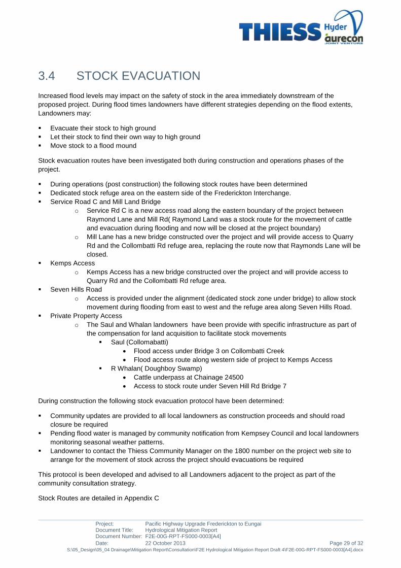
3.4 STOCK EVACUATION
Increased flood levels may impact on the safety of stock in the area immediately downstream of the
proposed project. During flood times landowners have different strategies depending on the flood extents,
Landowners may:
Evacuate their stock to high ground
Let their stock to find their own way to high ground
Move stock to a flood mound
Stock evacuation routes have been investigated both during construction and operations phases of the
project.
During operations (post construction) the following stock routes have been determined
Dedicated stock refuge area on the eastern side of the Frederickton Interchange.
Service Road C and Mill Land Bridge
o Service Rd C is a new access road along the eastern boundary of the project between
Raymond Lane and Mill Rd( Raymond Land was a stock route for the movement of cattle
and evacuation during flooding and now will be closed at the project boundary)
o Mill Lane has a new bridge constructed over the project and will provide access to Quarry
Rd and the Collombatti Rd refuge area, replacing the route now that Raymonds Lane will be
closed.
Kemps Access
o Kemps Access has a new bridge constructed over the project and will provide access to
Quarry Rd and the Collombatti Rd refuge area.
Seven Hills Road
o Access is provided under the alignment (dedicated stock zone under bridge) to allow stock
movement during flooding from east to west and the refuge area along Seven Hills Road.
Private Property Access
o The Saul and Whalan landowners have been provide with specific infrastructure as part of
the compensation for land acquisition to facilitate stock movements
Saul (Collomabatti)
Flood access under Bridge 3 on Collombatti Creek
Flood access route along western side of project to Kemps Access
R Whalan( Doughboy Swamp)
Cattle underpass at Chainage 24500
Access to stock route under Seven Hill Rd Bridge 7
During construction the following stock evacuation protocol have been determined:
Community updates are provided to all local landowners as construction proceeds and should road
closure be required
Pending flood water is managed by community notification from Kempsey Council and local landowners
monitoring seasonal weather patterns.
Landowner to contact the Thiess Community Manager on the 1800 number on the project web site to
arrange for the movement of stock across the project should evacuations be required
This protocol is been developed and advised to all Landowners adjacent to the project as part of the
community consultation strategy.
Stock Routes are detailed in Appendix C

Project: Pacific Highway Upgrade Frederickton to Eungai Document Title: Hydrological Mitigation Report Document Number: F2E-00G-RPT-FS000-0003[A4]
Page 30 of 32 Date: 22 October 2013 S:\05_Design\05_04 Drainage\Mitigation Report\Consultation\F2E Hydrological Mitigation Report Draft 4\F2E-00G-RPT-FS000-0003[A4].docx
3.5 PROTECTION AGAINST INCREASED VELOCITY
The proposed cross drainage structures will introduce flow contractions which will locally increase flow
velocities. The design of these structures incorporates appropriate local scour protection and no additional
scour protection outside of the property boundary is required.
Consultation with the Environmental Representatives Group (ERG) for the project has discussed the local
scour protection across the project and have had the opportunity to contribute to the design on scour
protection. EPA, NSW Fisheries, Kempsey Council have all been involved during the project delivery.
The design of scour protection at bridges has been undertaken by HAJV to prevent soil erosion at the bridge
piers and abutments for all events up to and including the 2,000 year flood. As part of the exercise, hydraulic
modelling was performed which determined how local velocities would increase slightly in the immediate
vicinity of the floodplain bridges ie. Upstream and downstream of the bridge openings. Much of the affected
land lies in the road corridor owned by RMS. It is intended for these areas to have suitable scour protection
to minimise localised soil erosion and/or pasture damage.
HAJV has also designed scour protection for drainage outlet/inlet works at the culvert crossings to minimise
localised soil erosion and/or pasture damage and all this is contained within the project boundary and no
additional scour protection is required.
3.6 MAINTENANCE
Operational and maintenance responsibility for the works outside the property boundary (private lands) lie
with the landowner following sign off that the works are complete as per the scope of works/deed agreement
between RMS/Thiess and the landowner. For all the mitigation measures that are contained within the
project boundary, RMS is responsible for maintenance. RMS is also responsible for all maintenance of the
bridges, culverts and scour provision. Regular maintenance inspection will be undertaken during the
operational phase of the project.

Project: Pacific Highway Upgrade Frederickton to Eungai Document Title: Hydrological Mitigation Report Document Number: F2E-00G-RPT-FS000-0003[A4]
Date: 22 October 2013 Page 31 of 32 S:\05_Design\05_04 Drainage\Mitigation Report\Consultation\F2E Hydrological Mitigation Report Draft 4\F2E-00G-RPT-FS000-0003[A4].docx
4 CONCLUSIONS
Due to the configuration of the farms crossed by the Frederickton to Eungai section of the Kempsey to
Eungai project, the evacuation of stock from the floodplain would be carried out by walking stock to high
ground. In most cases, higher ground is available within the properties, and access has been provided as a
project requirement.
A summary of the flood mitigation elements provided as part of the F2E project is provided in the following
Table 4-4 Summary of F2E flood mitigations
Reference Mitigation
Mill Lane Mill Lane is an over bridge providing connectivity between access road A and Quarry Road for local traffic and can be used during flood events as an evacuation route. It runs east to west over the highway corridor and has been fitted with translucent throw screen to prevent ‘spooking’ of cattle.
Temporary road diversions will be in place during construction to facilitate the movement of cattle during a flood event. An emergency evacuation plan will be developed in consultation with landowners
Kemps Access Kemps Access is an over bridge identified in the EA as the primary stock emergency evacuation route. It runs east to west over the highway corridor and maintains connectivity for cattle to pass from the floodplain on the east to the higher ground on the west.
Clybucca Creek Bridge A bridge identified in the EA that allows cattle to move from eastern side of the alignment to the western side and away from rising flood waters.
R. Whalen Access Principle farm access identified in the EA that allows cattle to move from eastern side of the alignment to the western side farm access. In addition to the EA commitments RMS are providing cattle yards to assist with movement of cattle in flood events.
‘Johnsons Creek’ Bridge
A bridge identified in the EA that allows cattle to move from eastern side of the alignment to the western side and away from rising flood waters.
Campbell/Saul property
RMS provided a flood evacuation route through negotiations with landowner in lieu of the farm access identified in the EA. Landowner requested flood access between properties to allow cattle a natural escape route during flood events.
Cattle Movement Cattle movement will be undertaken during construction in consultation with the landowner to allow stock to cross the construction works in time of flooding.
The project affluxes are deemed minimal and are not impacting nearby properties for the Frederickton to
Eungai section of the overall Kempsey to Eungai Project. The F2E design is considered to be satisfactory
and complies with the project’s hydraulic impact requirements and no additional flood mitigation elements are
required.

Project: Pacific Highway Upgrade Frederickton to Eungai Document Title: Hydrological Mitigation Report Document Number: F2E-00G-RPT-FS000-0003[A4]
Page 32 of 32 Date: 22 October 2013 S:\05_Design\05_04 Drainage\Mitigation Report\Consultation\F2E Hydrological Mitigation Report Draft 4\F2E-00G-RPT-FS000-0003[A4].docx
5 REFERENCES
• Hyder Aurecon Joint Venture, Frederickton to Eungai Flood Study, 2013
• NSW Department of Planning, Kempsey to Eungai – Approval by the NSW Minister of Planning Roads
and Traffic Authority, July 2008
• NSW Government, Floodplain Development Manual April 2005
• Parsons Brinckerhoff, Kempsey to Eungai – Environmental Assessment Roads and Traffic Authority,
July 2007.
• RTA, Kempsey to Eungai – Upgrading the Pacific Highway, Submissions Report, Appendix C Revised
Statement of Commitments Roads and Traffic Authority, 6 Feb 2008
• WMAWater, Kempsey to Eungai – Upgrading the Pacific Highway, Project Application Report –
Supporting Information, Flood Investigations Roads and Traffic Authority, July 2006.
• WMAWater, Kempsey to Eungai – Upgrading the Pacific Highway, Environmental Assessment Roads
and Traffic Authority, May 2007.
• WMAWater, Kempsey Bypass –Flood Impact Assessment Kempsey Bypass Alliance, 2010
• WMAWater, Frederickton to Eungai Bypass Impacts – Collombatti Creek, 201
Project: Pacific Highway Upgrade Frederickton to Eungai Document Title: Hydrological Mitigation Report Document Number: F2E-00G-RPT-FS000-0003[A4]
Date: 22 October 2013 S:\05_Design\05_04 Drainage\Mitigation Report\Consultation\F2E Hydrological Mitigation Report Draft 4\F2E-00G-RPT-FS000-0003[A4].docx
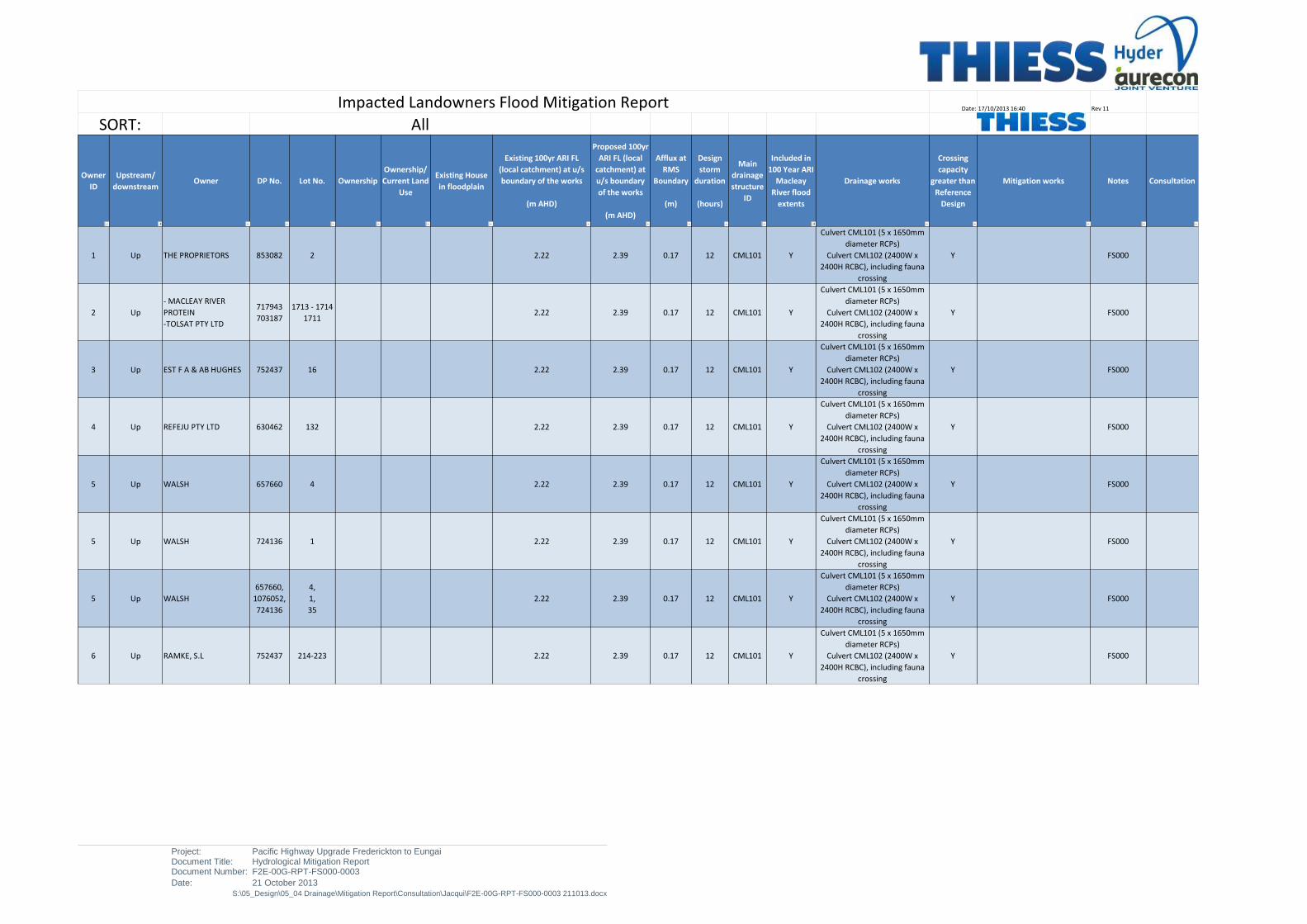
APPENDIX A
FREDERICKTON TO EUNGAI BYPASS IMPACTS – OVERALL PROJECT FLOOD IMPACT 100 YEARS ARI
Project: Pacific Highway Upgrade Frederickton to Eungai Document Title: Hydrological Mitigation Report Document Number: F2E-00G-RPT-FS000-0003
Date: 21 October 2013 S:\05_Design\05_04 Drainage\Mitigation Report\Consultation\Jacqui\F2E-00G-RPT-FS000-0003 211013.docx
Date: 17/10/2013 16:40 Rev 11
Owner
ID
Upstream/
downstreamOwner DP No. Lot No. Ownership
Ownership/
Current Land
Use
Existing House
in floodplain
Existing 100yr ARI FL
(local catchment) at u/s
boundary of the works
(m AHD)
Proposed 100yr
ARI FL (local
catchment) at
u/s boundary
of the works
(m AHD)
Afflux at
RMS
Boundary
(m)
Design
storm
duration
(hours)
Main
drainage
structure
ID
Included in
100 Year ARI
Macleay
River flood
extents
Drainage works
Crossing
capacity
greater than
Reference
Design
Mitigation works Notes Consultation
1 Up THE PROPRIETORS 853082 2 2.22 2.39 0.17 12 CML101 Y
Culvert CML101 (5 x 1650mm
diameter RCPs)
Culvert CML102 (2400W x
2400H RCBC), including fauna
crossing
Y FS000
2 Up
- MACLEAY RIVER
PROTEIN
-TOLSAT PTY LTD
717943
703187
1713 - 1714
17112.22 2.39 0.17 12 CML101 Y
Culvert CML101 (5 x 1650mm
diameter RCPs)
Culvert CML102 (2400W x
2400H RCBC), including fauna
crossing
Y FS000
3 Up EST F A & AB HUGHES 752437 16 2.22 2.39 0.17 12 CML101 Y
Culvert CML101 (5 x 1650mm
diameter RCPs)
Culvert CML102 (2400W x
2400H RCBC), including fauna
crossing
Y FS000
4 Up REFEJU PTY LTD 630462 132 2.22 2.39 0.17 12 CML101 Y
Culvert CML101 (5 x 1650mm
diameter RCPs)
Culvert CML102 (2400W x
2400H RCBC), including fauna
crossing
Y FS000
5 Up WALSH 657660 4 2.22 2.39 0.17 12 CML101 Y
Culvert CML101 (5 x 1650mm
diameter RCPs)
Culvert CML102 (2400W x
2400H RCBC), including fauna
crossing
Y FS000
5 Up WALSH 724136 1 2.22 2.39 0.17 12 CML101 Y
Culvert CML101 (5 x 1650mm
diameter RCPs)
Culvert CML102 (2400W x
2400H RCBC), including fauna
crossing
Y FS000
5 Up WALSH
657660,
1076052,
724136
4,
1,
35
2.22 2.39 0.17 12 CML101 Y
Culvert CML101 (5 x 1650mm
diameter RCPs)
Culvert CML102 (2400W x
2400H RCBC), including fauna
crossing
Y FS000
6 Up RAMKE, S.L 752437 214-223 2.22 2.39 0.17 12 CML101 Y
Culvert CML101 (5 x 1650mm
diameter RCPs)
Culvert CML102 (2400W x
2400H RCBC), including fauna
crossing
Y FS000
Impacted Landowners Flood Mitigation Report
SORT: All

Project: Pacific Highway Upgrade Frederickton to Eungai Document Title: Hydrological Mitigation Report Document Number: F2E-00G-RPT-FS000-0003
Date: 21 October 2013 S:\05_Design\05_04 Drainage\Mitigation Report\Consultation\Jacqui\F2E-00G-RPT-FS000-0003 211013.docx
Date: 17/10/2013 16:40 Rev 11
Owner
ID
Upstream/
downstreamOwner DP No. Lot No. Ownership
Ownership/
Current Land
Use
Existing House
in floodplain
Existing 100yr ARI FL
(local catchment) at u/s
boundary of the works
(m AHD)
Proposed 100yr
ARI FL (local
catchment) at
u/s boundary
of the works
(m AHD)
Afflux at
RMS
Boundary
(m)
Design
storm
duration
(hours)
Main
drainage
structure
ID
Included in
100 Year ARI
Macleay
River flood
extents
Drainage works
Crossing
capacity
greater than
Reference
Design
Mitigation works Notes Consultation
Impacted Landowners Flood Mitigation Report
SORT: All
8 Up TURLEY, HEFFERNAN 857721 1 2.22 2.39 0.17 12 CML101 Y
Culvert CML101 (5 x 1650mm
diameter RCPs)
Culvert CML102 (2400W x
2400H RCBC), including fauna
crossing
Y FS000
7 Up ROOTS, G.N 752437 227-229 2.22 2.39 0.17 12 CML101 Y Culvert CML101 (5 x 1650mm diameter RCPs)Culvert CML102 (2400W x 2400H RCBC), including fauna crossingY FS000
13 Up
RMS
"Ramke"
"The Proprietors"
(old)
752437
96738
30,33
7009RMS Agriculture No 2.22 2.39 0.17 12 CML101 Y
Culvert CML101 (5 x 1650mm
diameter RCPs)
Culvert CML102 (2400W x
2400H RCBC), including fauna
crossing
Y FS000
17 Up RAMKE, S.L 752437 38 PrivateRural
residentialNo 3.45 4.29 0.84 3 CML104 Y
Culvert CML104 (3 x 1500mm
diameter RCPs)Y
Access Road A, Mill Lane
Bridge and Quarry Road: east
to west access to and fron
Raymonds Lane and Seashore
Lane allowing cattle crossing in
and out of floodplain, with
improved Quarry Road flood
immunity
DC001
19 Up FLANIGAN 855351 4 2.65 3.51 0.86 4 CML107 Y
Culvert CML107 (3 x 2700W x
2700H RCBCs) including fauna
access
Y DC001
20 UpRMS
"Ramke" (old)752437 45 RMS
Rural
residentialNo 2.65 3.51 0.86 4 CML107 Y
Culvert CML107 (3 x 2700W x
2700H RCBCs) including fauna
access
Y DC001
21 Up RAMKE, S.L 752437 51-52 0.00 y
Downstream
of highway -
NO
HYDRAULIC
IMPACT
22 Up LESTER 631274 3 2.70 2.86 0.16 > 24
BR003
BR004
BR006
Y
BR003 Collombatti Creek
bridge
BR004 Seven Oaks Drain Bridge
BR006 Collambatti floodplain
bridge
Y
East to west farm access under
highway allowing crossing in
and out of floodplain
Refer
Frederickton
to Eungai
Bypass
Impacts -
Collombatti
Creek
(WMAWater,
2012)

Project: Pacific Highway Upgrade Frederickton to Eungai Document Title: Hydrological Mitigation Report Document Number: F2E-00G-RPT-FS000-0003
Date: 21 October 2013 S:\05_Design\05_04 Drainage\Mitigation Report\Consultation\Jacqui\F2E-00G-RPT-FS000-0003 211013.docx
Date: 17/10/2013 16:40 Rev 11
Owner
ID
Upstream/
downstreamOwner DP No. Lot No. Ownership
Ownership/
Current Land
Use
Existing House
in floodplain
Existing 100yr ARI FL
(local catchment) at u/s
boundary of the works
(m AHD)
Proposed 100yr
ARI FL (local
catchment) at
u/s boundary
of the works
(m AHD)
Afflux at
RMS
Boundary
(m)
Design
storm
duration
(hours)
Main
drainage
structure
ID
Included in
100 Year ARI
Macleay
River flood
extents
Drainage works
Crossing
capacity
greater than
Reference
Design
Mitigation works Notes Consultation
Impacted Landowners Flood Mitigation Report
SORT: All
23 Up COOPER 631274 4 2.70 2.86 0.16 > 24
BR003
BR004
BR006
Y
BR003 Collombatti Creek
bridge
BR004 Seven Oaks Drain Bridge
BR006 Collambatti floodplain
bridge
Y
East to west farm access under
highway allowing crossing in
and out of floodplain
Refer
Frederickton
to Eungai
Bypass
Impacts -
Collombatti
Creek
(WMAWater,
2012)
24 Up MENZ 752437 54 2.70 2.86 0.16 > 24
BR003
BR004
BR006
Y
BR003 Collombatti Creek
bridge
BR004 Seven Oaks Drain Bridge
BR006 Collambatti floodplain
bridge
Y
East to west farm access under
highway allowing crossing in
and out of floodplain
Refer
Frederickton
to Eungai
Bypass
Impacts -
Collombatti
Creek
(WMAWater,
2012)
25 Up HAWKEN 702418 3 2.70 2.86 0.16 > 24
BR003
BR004
BR006
Y
BR003 Collombatti Creek
bridge
BR004 Seven Oaks Drain Bridge
BR006 Collambatti floodplain
bridge
Y
East to west farm access under
highway allowing crossing in
and out of floodplain
Refer
Frederickton
to Eungai
Bypass
Impacts -
Collombatti
Creek
(WMAWater,
2012)
26 Up MUXLOW 1040040 1032 2.70 2.86 0.16 > 24
BR003
BR004
BR006
Y
BR003 Collombatti Creek
bridge
BR004 Seven Oaks Drain Bridge
BR006 Collambatti floodplain
bridge
Y
East to west farm access under
highway allowing crossing in
and out of floodplain
Refer
Frederickton
to Eungai
Bypass
Impacts -
Collombatti
Creek
(WMAWater,
2012)
27 Up THE PROPRIETORS 308270 B 2.70 2.86 0.16 > 24
BR003
BR004
BR006
Y
BR003 Collombatti Creek
bridge
BR004 Seven Oaks Drain Bridge
BR006 Collambatti floodplain
bridge
Y
East to west farm access under
highway allowing crossing in
and out of floodplain
Refer
Frederickton
to Eungai
Bypass
Impacts -
Collombatti
Creek
(WMAWater,
2012)

Project: Pacific Highway Upgrade Frederickton to Eungai Document Title: Hydrological Mitigation Report Document Number: F2E-00G-RPT-FS000-0003
Date: 21 October 2013 S:\05_Design\05_04 Drainage\Mitigation Report\Consultation\Jacqui\F2E-00G-RPT-FS000-0003 211013.docx
Date: 17/10/2013 16:40 Rev 11
Owner
ID
Upstream/
downstreamOwner DP No. Lot No. Ownership
Ownership/
Current Land
Use
Existing House
in floodplain
Existing 100yr ARI FL
(local catchment) at u/s
boundary of the works
(m AHD)
Proposed 100yr
ARI FL (local
catchment) at
u/s boundary
of the works
(m AHD)
Afflux at
RMS
Boundary
(m)
Design
storm
duration
(hours)
Main
drainage
structure
ID
Included in
100 Year ARI
Macleay
River flood
extents
Drainage works
Crossing
capacity
greater than
Reference
Design
Mitigation works Notes Consultation
Impacted Landowners Flood Mitigation Report
SORT: All
28 UpSAUL, G.G & R.C
"Ramke" (old)752437
104, 105,
178, 179,
181
Private Agriculture No 2.70 2.86 0.16 > 24
BR003
BR004
BR006
Y
BR003 Collombatti Creek
bridge
BR004 Seven Oaks Drain Bridge
BR006 Collambatti floodplain
bridge
Y
East to west farm access under
highway at two locations
(Bridges BR003 and BR006)
allowing crossing in and out of
floodplain
Refer
Frederickton
to Eungai
Bypass
Impacts -
Collombatti
Creek
(WMAWater,
2012)
31 Up BARGH 1040040 1031 2.70 2.86 0.16 > 24
BR003
BR004
BR006
Y
BR003 Collombatti Creek
bridge
BR004 Seven Oaks Drain Bridge
BR006 Collambatti floodplain
bridge
Y
East to west farm access under
highway at two locations
(Bridges BR003 and BR006)
allowing crossing in and out of
floodplain
Refer
Frederickton
to Eungai
Bypass
Impacts -
Collombatti
Creek
(WMAWater,
2012)
33 Up UNKNOWN 21463 1 2.70 2.86 0.16 > 24
BR003
BR004
BR006
Y
BR003 Collombatti Creek
bridge
BR004 Seven Oaks Drain Bridge
BR006 Collambatti floodplain
bridge
Y
East to west farm access under
highway at two locations
(Bridges BR003 and BR006)
allowing crossing in and out of
floodplain
Refer
Frederickton
to Eungai
Bypass
Impacts -
Collombatti
Creek
(WMAWater,
2012)
34 Up SAUL 717797 21/22 2.70 2.86 0.16 > 24
BR003
BR004
BR006
Y
BR003 Collombatti Creek
bridge
BR004 Seven Oaks Drain Bridge
BR006 Collambatti floodplain
bridge
Y
East to west farm access under
highway at two locations
(Bridges BR003 and BR006)
allowing crossing in and out of
floodplain
Refer
Frederickton
to Eungai
Bypass
Impacts -
Collombatti
Creek
(WMAWater,
2012)
35 Up BRIE 809123 7 0.00 Y
Impact within
the Macleay
River Flood
Plain. No
additional
Impacts

Project: Pacific Highway Upgrade Frederickton to Eungai Document Title: Hydrological Mitigation Report Document Number: F2E-00G-RPT-FS000-0003
Date: 21 October 2013 S:\05_Design\05_04 Drainage\Mitigation Report\Consultation\Jacqui\F2E-00G-RPT-FS000-0003 211013.docx
.
Date: 17/10/2013 16:40 Rev 11
Owner
ID
Upstream/
downstreamOwner DP No. Lot No. Ownership
Ownership/
Current Land
Use
Existing House
in floodplain
Existing 100yr ARI FL
(local catchment) at u/s
boundary of the works
(m AHD)
Proposed 100yr
ARI FL (local
catchment) at
u/s boundary
of the works
(m AHD)
Afflux at
RMS
Boundary
(m)
Design
storm
duration
(hours)
Main
drainage
structure
ID
Included in
100 Year ARI
Macleay
River flood
extents
Drainage works
Crossing
capacity
greater than
Reference
Design
Mitigation works Notes Consultation
Impacted Landowners Flood Mitigation Report
SORT: All
36 Up UNKNOWN 21463 3 2.70 2.86 0.16 > 24
BR003
BR004
BR006
Y
BR003 Collombatti Creek
bridge
BR004 Seven Oaks Drain Bridge
BR006 Collambatti floodplain
bridge
Y
East to west farm access under
highway at two locations
(Bridges BR003 and BR006)
allowing crossing in and out of
floodplain
Refer
Frederickton
to Eungai
Bypass
Impacts -
Collombatti
Creek
(WMAWater,
2012)
37 Up owner not identified 21463 4 2.70 2.86 0.16 > 24
BR003
BR004
BR006
Y
BR003 Collombatti Creek
bridge
BR004 Seven Oaks Drain Bridge
BR006 Collambatti floodplain
bridge
Y
East to west farm access under
highway at two locations
(Bridges BR003 and BR006)
allowing crossing in and out of
floodplain
Refer
Frederickton
to Eungai
Bypass
Impacts -
Collombatti
Creek
(WMAWater,
2012)
40 Up THE PROPRIETORS 364311 1 2.59 3.05 0.46 12 BR008 Y BR008 Clybucca Creek Bridge =
East to west farm access under
highway at two locations
(Bridge BR008 and culvert
CML203a) allowing crossing in
and out of floodplain
FS000
41 UpARTC
Name not on GIS172701 1 2.59 3.05 0.46 12 BR008 Y BR008 Clybucca Creek Bridge =
East to west farm access under
highway at two locations
(Bridge BR008 and culvert
CML203a) allowing crossing in
and out of floodplain
FS000
45 Up THE PROPRIETORS 841050 92 2.59 3.05 0.46 12 BR008 Y BR008 Clybucca Creek Bridge =
East to west farm access under
highway at two locations
(Bridge BR008 and culvert
CML203a) allowing crossing in
and out of floodplain
FS000
46 UpDANDARAGA
ENTERPRISE PTY LTD841050 91 2.59 3.05 0.46 12 BR008 Y BR008 Clybucca Creek Bridge =
East to west farm access under
highway at two locations
(Bridge BR008 and culvert
CML203a) allowing crossing in
and out of floodplain
FS000

Project: Pacific Highway Upgrade Frederickton to Eungai Document Title: Hydrological Mitigation Report Document Number: F2E-00G-RPT-FS000-0003
Date: 21 October 2013 S:\05_Design\05_04 Drainage\Mitigation Report\Consultation\Jacqui\F2E-00G-RPT-FS000-0003 211013.docx
Date: 17/10/2013 16:40 Rev 11
Owner
ID
Upstream/
downstreamOwner DP No. Lot No. Ownership
Ownership/
Current Land
Use
Existing House
in floodplain
Existing 100yr ARI FL
(local catchment) at u/s
boundary of the works
(m AHD)
Proposed 100yr
ARI FL (local
catchment) at
u/s boundary
of the works
(m AHD)
Afflux at
RMS
Boundary
(m)
Design
storm
duration
(hours)
Main
drainage
structure
ID
Included in
100 Year ARI
Macleay
River flood
extents
Drainage works
Crossing
capacity
greater than
Reference
Design
Mitigation works Notes Consultation
Impacted Landowners Flood Mitigation Report
SORT: All
47 Up THE PROPRIETORS 188975 1 3.34 4.25 0.91 9CML203 /
CML204Y
Culvert CML203 (5 x 1800mm
diameter RCPs)
Culvert CML204 (4 x 1800mm
diameter RCPs)
Y
East to west farm access under
highway at two locations
(Bridge BR008 and culvert
CML203a) allowing crossing in
and out of floodplain
FS000
50 Up THE PROPRIETORS 657555 1
2.92
3.10
3.10
3.76
3.23
3.23
0.85
0.15
0.15
2
CML206
CML207
CML208
Y
Culvert CML206 (1 x 1800mm
diameter RCP)
Culvert CML207 (1 x 2700 x
2400mm RCBC)
Culcvert CML208 (3 x 2700 x
900mm RCBC)
Y
East to west farm access under
highway at two locations
(Bridge BR008 and culvert
CML203a) allowing crossing in
and out of floodplain
FS000
51 UpKELLY, COLLINS,
COLLINS752428 22, 32, 37
3.10
3.10
3.23
3.23
0.15
0.152
CML207
CML208Y
Culvert CML207 (1 x 2700 x
2400mm RCBC)
Culcvert CML208 (3 x 2700 x
900mm RCBC)
Y
East to west farm access under
highway at two locations
(Bridge BR008 and culvert
CML203a) allowing crossing in
and out of floodplain
FS000
52 Up RMS
(LAND
BACK TO
FORESTRY
)
3.10
3.10
3.23
3.23
0.15
0.152
CML207
CML208Y
Culvert CML207 (1 x 2700 x
2400mm RCBC)
Culcvert CML208 (3 x 2700 x
900mm RCBC)
Y
East to west farm access under
highway at two locations
(Bridge BR008 and culvert
CML203a) allowing crossing in
and out of floodplain
FS000
60 Up WATTS, D.J 789638 403 PrivateRural
residentialNo 2.18 2.29 0.11 18 BR012 Y
BR012 Johnsons Creek Bridge;
Proposed bridge has span
longer than the reference
design
Y
East to west farm access under
highway (Bridge BR012)
allowing crossing in and out of
floodplain
FS000
61 Up ROLICO PTY LTD 789638 402 2.18 2.29 0.11 18 BR012 Y
BR012 Johnsons Creek Bridge;
Proposed bridge has span
longer than the reference
design
Y
East to west farm access under
highway (Bridge BR012)
allowing crossing in and out of
floodplain
FS000
62 UpMACINTYRE, I.G &
DANIAL G789638 401 2.18 2.29 0.11 18 BR012 Y
BR012 Johnsons Creek Bridge;
Proposed bridge has span
longer than the reference
design
Y
East to west farm access under
highway (Bridge BR012)
allowing crossing in and out of
floodplain
FS000
63 Up RMS return to forestry 546108 3 2.18 2.29 0.11 18 BR012 Y
BR012 Johnsons Creek Bridge;
Proposed bridge has span
longer than the reference
design
Y
East to west farm access under
highway (Bridge BR012)
allowing crossing in and out of
floodplain
FS000

Project: Pacific Highway Upgrade Frederickton to Eungai Document Title: Hydrological Mitigation Report Document Number: F2E-00G-RPT-FS000-0003
Date: 21 October 2013 S:\05_Design\05_04 Drainage\Mitigation Report\Consultation\Jacqui\F2E-00G-RPT-FS000-0003 211013.docx
Date: 17/10/2013 16:40 Rev 11
Owner
ID
Upstream/
downstreamOwner DP No. Lot No. Ownership
Ownership/
Current Land
Use
Existing House
in floodplain
Existing 100yr ARI FL
(local catchment) at u/s
boundary of the works
(m AHD)
Proposed 100yr
ARI FL (local
catchment) at
u/s boundary
of the works
(m AHD)
Afflux at
RMS
Boundary
(m)
Design
storm
duration
(hours)
Main
drainage
structure
ID
Included in
100 Year ARI
Macleay
River flood
extents
Drainage works
Crossing
capacity
greater than
Reference
Design
Mitigation works Notes Consultation
Impacted Landowners Flood Mitigation Report
SORT: All
64 UpKEITH L & EDWARDS,
I.P752428 39 2.18 2.29 0.11 18 BR012 Y
BR012 Johnsons Creek Bridge;
Proposed bridge has span
longer than the reference
design
Y
East to west farm access under
highway (Bridge BR012)
allowing crossing in and out of
floodplain
FS000
65 UpKELLY, COLLINS,
COLLINS752428 41 2.18 2.29 0.11 18 BR012 Y
BR012 Johnsons Creek Bridge;
Proposed bridge has span
longer than the reference
design
Y
East to west farm access under
highway (Bridge BR012)
allowing crossing in and out of
floodplain
FS000
66 UpBLOOMFIELD, A.R, K.J &
P752428 43 2.18 2.29 0.11 18 BR012 Y
BR012 Johnsons Creek Bridge;
Proposed bridge has span
longer than the reference
design
Y
East to west farm access under
highway (Bridge BR012)
allowing crossing in and out of
floodplain
FS000
67 UpBLOOMFIELD, A.R, K.J &
P752428 43 3.5 4.08 0.58 1 CML302 y
Culvert CML302 (2 x 825mm
diameter RCP) Y DC003
67 UpMALCOLM EDWARD
WRIGHT774189 42 2.55 3.28 0.73 3 CML303 Y
Culvert CML303 (4 x 1500mm
diameter RCP) Y FS000
67 UpMALCOLM EDWARD
WRIGHT774189 42 2.18 2.29 0.11 18 BR012 Y
BR012 Johnsons Creek Bridge;
Proposed bridge has span
longer than the reference
design
Y
East to west farm access under
highway (Bridge BR012)
allowing crossing in and out of
floodplain
FS000
69 Up MURPHY 774189 43 2.18 2.29 0.11 18 BR012 Y
BR012 Johnsons Creek Bridge;
Proposed bridge has span
longer than the reference
design
Y
East to west farm access under
highway (Bridge BR012)
allowing crossing in and out of
floodplain
FS000
70 Up DUFFY, DUFFY 787879 1862 2.55 3.28 0.73 3 CML303 YCulvert CML303 (4 x 1500mm
diameter RCP) Y FS000
71 Up ROBSON, ROBSON 787879 1861 2.55 3.28 0.73 3 CML303 YCulvert CML303 (4 x 1500mm
diameter RCP) Y FS000
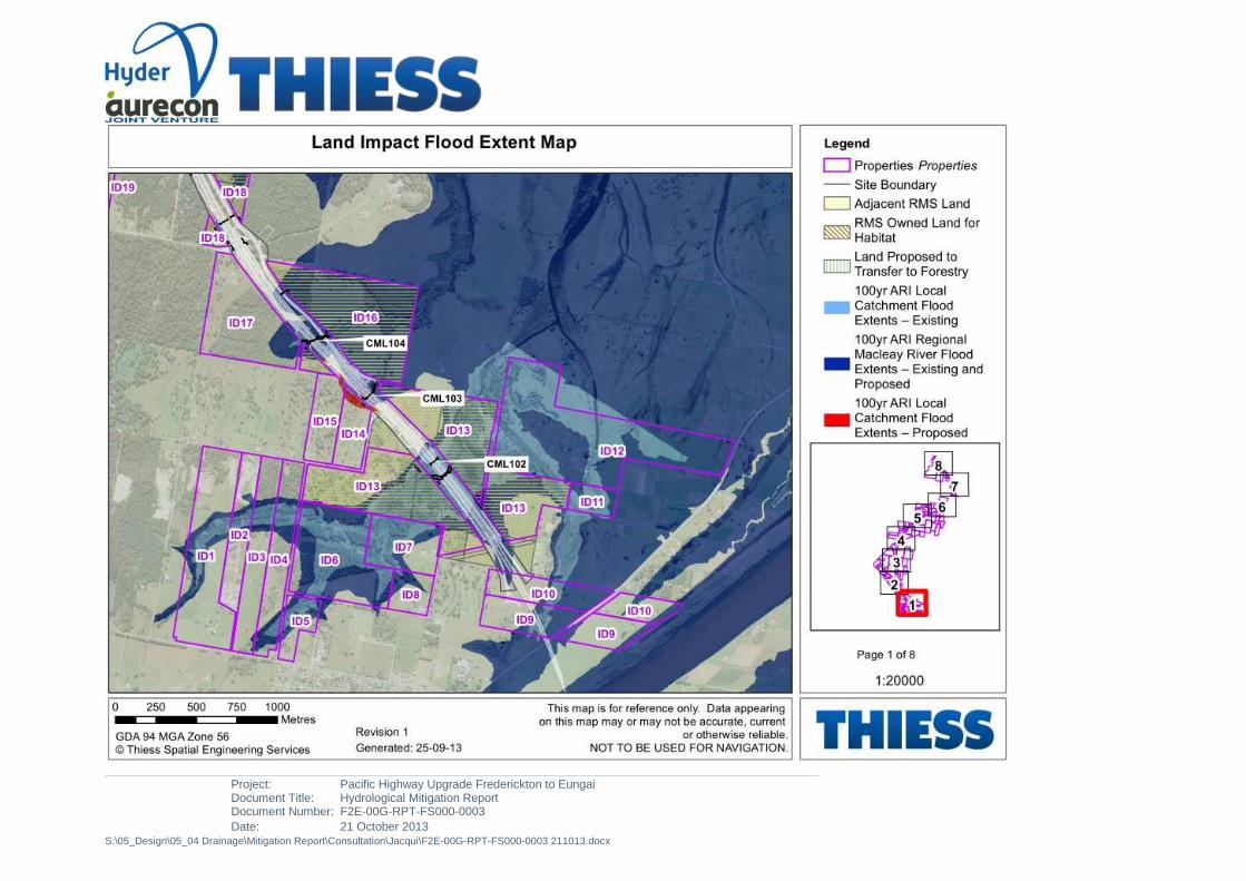
Project: Pacific Highway Upgrade Frederickton to Eungai Document Title: Hydrological Mitigation Report Document Number: F2E-00G-RPT-FS000-0003
Date: 21 October 2013 S:\05_Design\05_04 Drainage\Mitigation Report\Consultation\Jacqui\F2E-00G-RPT-FS000-0003 211013.docx

Project: Pacific Highway Upgrade Frederickton to Eungai Document Title: Hydrological Mitigation Report Document Number: F2E-00G-RPT-FS000-0003
Date: 21 October 2013 S:\05_Design\05_04 Drainage\Mitigation Report\Consultation\Jacqui\F2E-00G-RPT-FS000-0003 211013.docx
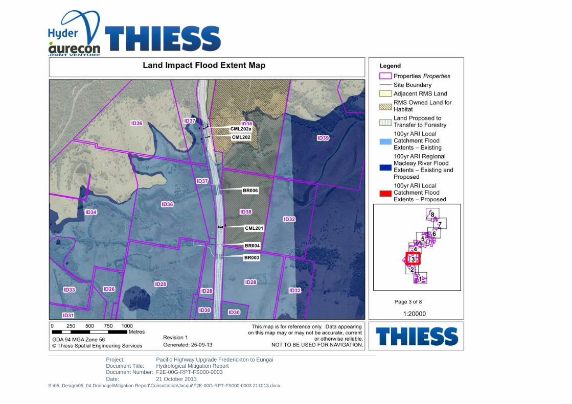
Project: Pacific Highway Upgrade Frederickton to Eungai Document Title: Hydrological Mitigation Report Document Number: F2E-00G-RPT-FS000-0003
Date: 21 October 2013 S:\05_Design\05_04 Drainage\Mitigation Report\Consultation\Jacqui\F2E-00G-RPT-FS000-0003 211013.docx
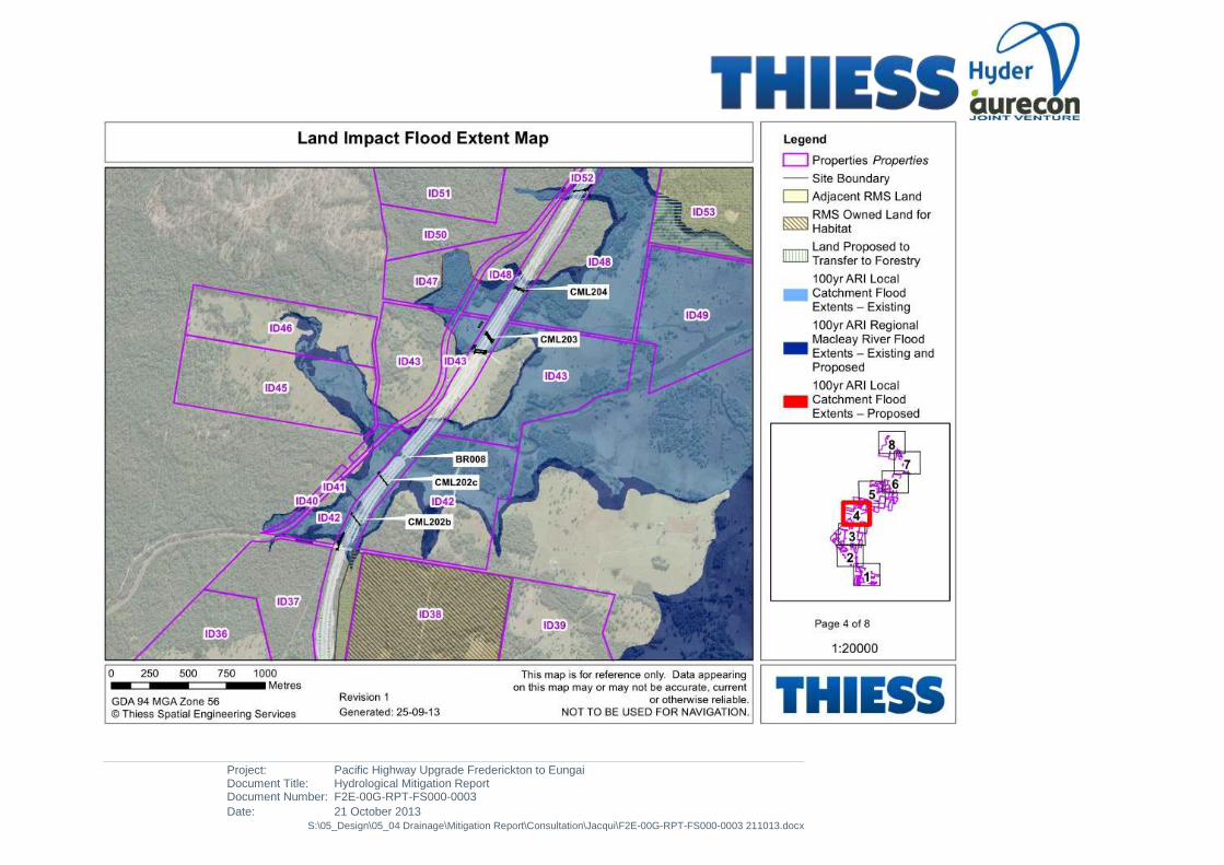
Project: Pacific Highway Upgrade Frederickton to Eungai Document Title: Hydrological Mitigation Report Document Number: F2E-00G-RPT-FS000-0003
Date: 21 October 2013 S:\05_Design\05_04 Drainage\Mitigation Report\Consultation\Jacqui\F2E-00G-RPT-FS000-0003 211013.docx

Project: Pacific Highway Upgrade Frederickton to Eungai Document Title: Hydrological Mitigation Report Document Number: F2E-00G-RPT-FS000-0003
Date: 21 October 2013 S:\05_Design\05_04 Drainage\Mitigation Report\Consultation\Jacqui\F2E-00G-RPT-FS000-0003 211013.docx

Project: Pacific Highway Upgrade Frederickton to Eungai Document Title: Hydrological Mitigation Report Document Number: F2E-00G-RPT-FS000-0003
Date: 21 October 2013 S:\05_Design\05_04 Drainage\Mitigation Report\Consultation\Jacqui\F2E-00G-RPT-FS000-0003 211013.docx

Project: Pacific Highway Upgrade Frederickton to Eungai Document Title: Hydrological Mitigation Report Document Number: F2E-00G-RPT-FS000-0003
Date: 21 October 2013 S:\05_Design\05_04 Drainage\Mitigation Report\Consultation\Jacqui\F2E-00G-RPT-FS000-0003 211013.docx

Project: Pacific Highway Upgrade Frederickton to Eungai Document Title: Hydrological Mitigation Report Document Number: F2E-00G-RPT-FS000-0003
Date: 21 October 2013 S:\05_Design\05_04 Drainage\Mitigation Report\Consultation\Jacqui\F2E-00G-RPT-FS000-0003 211013.docx

Project: Pacific Highway Upgrade Frederickton to Eungai Document Title: Hydrological Mitigation Report Document Number: F2E-00G-RPT-FS000-0003[A4]
Date: 22 October 2013 S:\05_Design\05_04 Drainage\Mitigation Report\Consultation\F2E Hydrological Mitigation Report Draft 4\F2E-00G-RPT-FS000-0003[A4].docx
APPENDIX B
FREDERICKTON TO EUNGAI BYPASS IMPACTS - PROPERTY IMPACTS
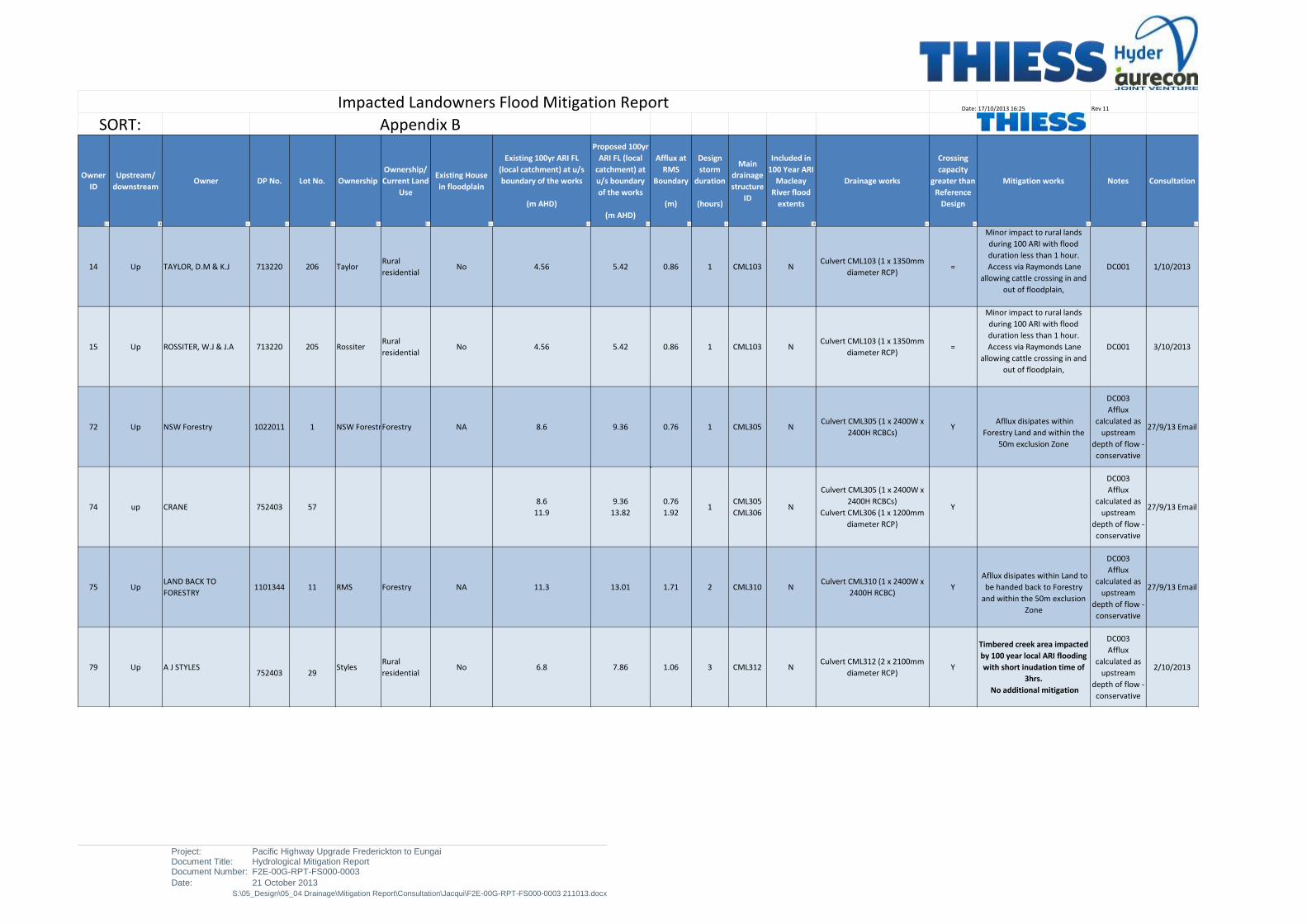
Project: Pacific Highway Upgrade Frederickton to Eungai Document Title: Hydrological Mitigation Report Document Number: F2E-00G-RPT-FS000-0003
Date: 21 October 2013 S:\05_Design\05_04 Drainage\Mitigation Report\Consultation\Jacqui\F2E-00G-RPT-FS000-0003 211013.docx
Date: 17/10/2013 16:25 Rev 11
Owner
ID
Upstream/
downstreamOwner DP No. Lot No. Ownership
Ownership/
Current Land
Use
Existing House
in floodplain
Existing 100yr ARI FL
(local catchment) at u/s
boundary of the works
(m AHD)
Proposed 100yr
ARI FL (local
catchment) at
u/s boundary
of the works
(m AHD)
Afflux at
RMS
Boundary
(m)
Design
storm
duration
(hours)
Main
drainage
structure
ID
Included in
100 Year ARI
Macleay
River flood
extents
Drainage works
Crossing
capacity
greater than
Reference
Design
Mitigation works Notes Consultation
14 Up TAYLOR, D.M & K.J 713220 206 TaylorRural
residentialNo 4.56 5.42 0.86 1 CML103 N
Culvert CML103 (1 x 1350mm
diameter RCP) =
Minor impact to rural lands
during 100 ARI with flood
duration less than 1 hour.
Access via Raymonds Lane
allowing cattle crossing in and
out of floodplain,
DC001 1/10/2013
15 Up ROSSITER, W.J & J.A 713220 205 RossiterRural
residentialNo 4.56 5.42 0.86 1 CML103 N
Culvert CML103 (1 x 1350mm
diameter RCP) =
Minor impact to rural lands
during 100 ARI with flood
duration less than 1 hour.
Access via Raymonds Lane
allowing cattle crossing in and
out of floodplain,
DC001 3/10/2013
72 Up NSW Forestry 1022011 1 NSW ForestryForestry NA 8.6 9.36 0.76 1 CML305 NCulvert CML305 (1 x 2400W x
2400H RCBCs) Y
Afllux disipates within
Forestry Land and within the
50m exclusion Zone
DC003
Afflux
calculated as
upstream
depth of flow -
conservative
27/9/13 Email
74 up CRANE 752403 578.6
11.9
9.36
13.82
0.76
1.921
CML305
CML306N
Culvert CML305 (1 x 2400W x
2400H RCBCs)
Culvert CML306 (1 x 1200mm
diameter RCP)
Y
DC003
Afflux
calculated as
upstream
depth of flow -
conservative
27/9/13 Email
75 UpLAND BACK TO
FORESTRY1101344 11 RMS Forestry NA 11.3 13.01 1.71 2 CML310 N
Culvert CML310 (1 x 2400W x
2400H RCBC) Y
Afllux disipates within Land to
be handed back to Forestry
and within the 50m exclusion
Zone
DC003
Afflux
calculated as
upstream
depth of flow -
conservative
27/9/13 Email
79 Up A J STYLES752403 29
StylesRural
residentialNo 6.8 7.86 1.06 3 CML312 N
Culvert CML312 (2 x 2100mm
diameter RCP) Y
Timbered creek area impacted
by 100 year local ARI flooding
with short inudation time of
3hrs.
No additional mitigation
DC003
Afflux
calculated as
upstream
depth of flow -
conservative
2/10/2013
Impacted Landowners Flood Mitigation Report
SORT: Appendix B
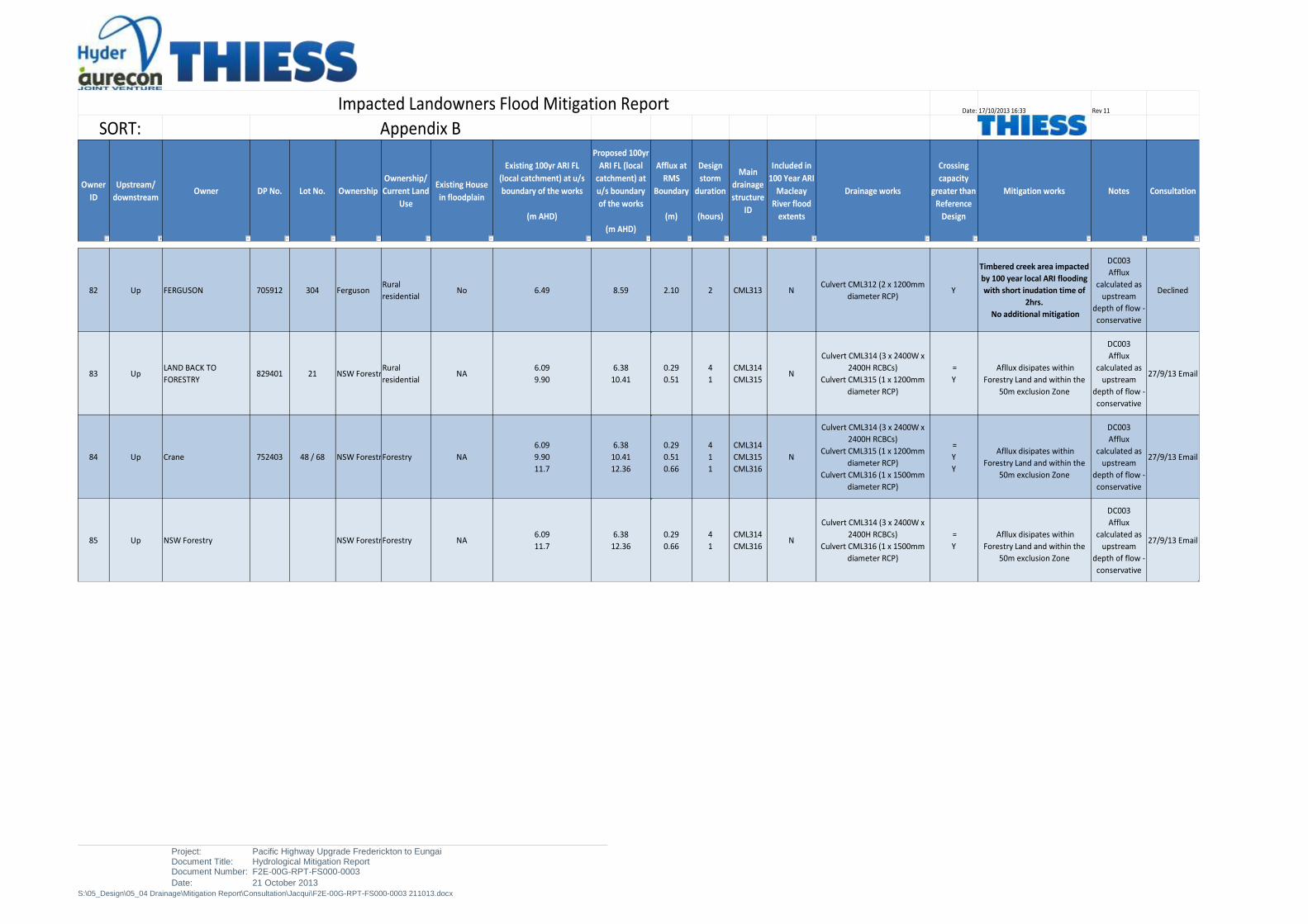
Project: Pacific Highway Upgrade Frederickton to Eungai Document Title: Hydrological Mitigation Report Document Number: F2E-00G-RPT-FS000-0003
Date: 21 October 2013 S:\05_Design\05_04 Drainage\Mitigation Report\Consultation\Jacqui\F2E-00G-RPT-FS000-0003 211013.docx
Date: 17/10/2013 16:33 Rev 11
Owner
ID
Upstream/
downstreamOwner DP No. Lot No. Ownership
Ownership/
Current Land
Use
Existing House
in floodplain
Existing 100yr ARI FL
(local catchment) at u/s
boundary of the works
(m AHD)
Proposed 100yr
ARI FL (local
catchment) at
u/s boundary
of the works
(m AHD)
Afflux at
RMS
Boundary
(m)
Design
storm
duration
(hours)
Main
drainage
structure
ID
Included in
100 Year ARI
Macleay
River flood
extents
Drainage works
Crossing
capacity
greater than
Reference
Design
Mitigation works Notes Consultation
Impacted Landowners Flood Mitigation Report
SORT: Appendix B
82 Up FERGUSON 705912 304 FergusonRural
residentialNo 6.49 8.59 2.10 2 CML313 N
Culvert CML312 (2 x 1200mm
diameter RCP) Y
Timbered creek area impacted
by 100 year local ARI flooding
with short inudation time of
2hrs.
No additional mitigation
DC003
Afflux
calculated as
upstream
depth of flow -
conservative
Declined
83 UpLAND BACK TO
FORESTRY829401 21 NSW Forestry
Rural
residentialNA
6.09
9.90
6.38
10.41
0.29
0.51
4
1
CML314
CML315N
Culvert CML314 (3 x 2400W x
2400H RCBCs)
Culvert CML315 (1 x 1200mm
diameter RCP)
=
Y
Afllux disipates within
Forestry Land and within the
50m exclusion Zone
DC003
Afflux
calculated as
upstream
depth of flow -
conservative
27/9/13 Email
84 Up Crane 752403 48 / 68 NSW ForestryForestry NA
6.09
9.90
11.7
6.38
10.41
12.36
0.29
0.51
0.66
4
1
1
CML314
CML315
CML316
N
Culvert CML314 (3 x 2400W x
2400H RCBCs)
Culvert CML315 (1 x 1200mm
diameter RCP)
Culvert CML316 (1 x 1500mm
diameter RCP)
=
Y
Y
Afllux disipates within
Forestry Land and within the
50m exclusion Zone
DC003
Afflux
calculated as
upstream
depth of flow -
conservative
27/9/13 Email
85 Up NSW Forestry NSW ForestryForestry NA6.09
11.7
6.38
12.36
0.29
0.66
4
1
CML314
CML316N
Culvert CML314 (3 x 2400W x
2400H RCBCs)
Culvert CML316 (1 x 1500mm
diameter RCP)
=
Y
Afllux disipates within
Forestry Land and within the
50m exclusion Zone
DC003
Afflux
calculated as
upstream
depth of flow -
conservative
27/9/13 Email
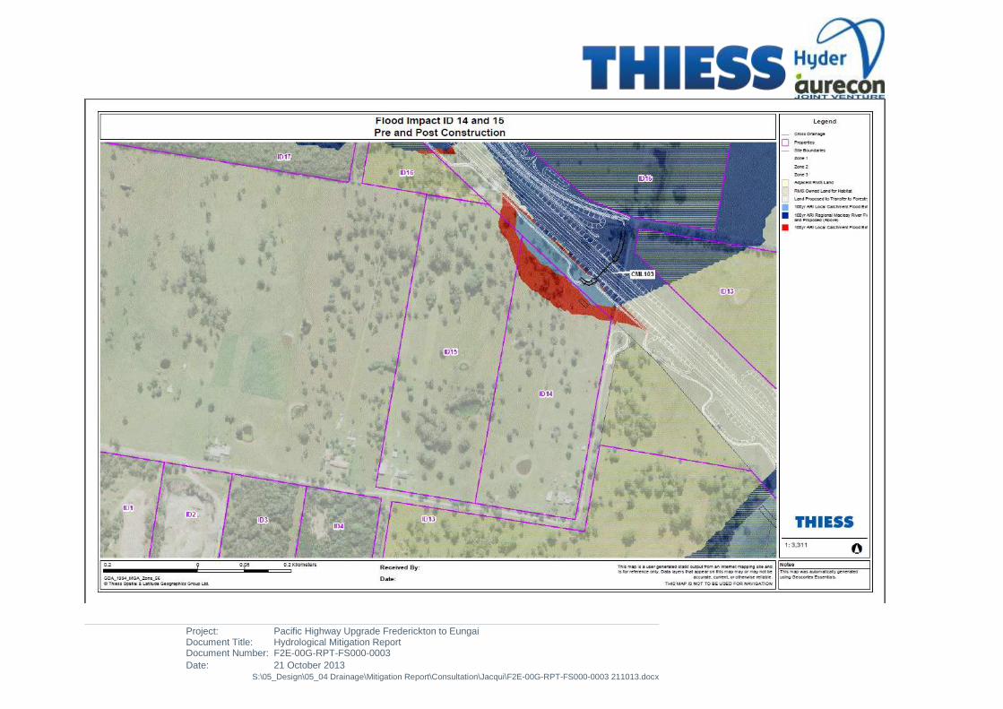
Project: Pacific Highway Upgrade Frederickton to Eungai Document Title: Hydrological Mitigation Report Document Number: F2E-00G-RPT-FS000-0003
Date: 21 October 2013 S:\05_Design\05_04 Drainage\Mitigation Report\Consultation\Jacqui\F2E-00G-RPT-FS000-0003 211013.docx

Project: Pacific Highway Upgrade Frederickton to Eungai Document Title: Hydrological Mitigation Report Document Number: F2E-00G-RPT-FS000-0003
Date: 21 October 2013 S:\05_Design\05_04 Drainage\Mitigation Report\Consultation\Jacqui\F2E-00G-RPT-FS000-0003 211013.docx

Project: Pacific Highway Upgrade Frederickton to Eungai Document Title: Hydrological Mitigation Report Document Number: F2E-00G-RPT-FS000-0003
Date: 21 October 2013 S:\05_Design\05_04 Drainage\Mitigation Report\Consultation\Jacqui\F2E-00G-RPT-FS000-0003 211013.docx
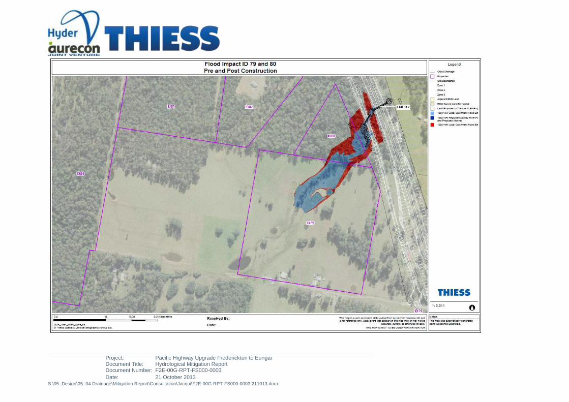
Project: Pacific Highway Upgrade Frederickton to Eungai Document Title: Hydrological Mitigation Report Document Number: F2E-00G-RPT-FS000-0003
Date: 21 October 2013 S:\05_Design\05_04 Drainage\Mitigation Report\Consultation\Jacqui\F2E-00G-RPT-FS000-0003 211013.docx

Project: Pacific Highway Upgrade Frederickton to Eungai Document Title: Hydrological Mitigation Report Document Number: F2E-00G-RPT-FS000-0003
Date: 21 October 2013 S:\05_Design\05_04 Drainage\Mitigation Report\Consultation\Jacqui\F2E-00G-RPT-FS000-0003 211013.docx

Project: Pacific Highway Upgrade Frederickton to Eungai Document Title: Hydrological Mitigation Report Document Number: F2E-00G-RPT-FS000-0003
Date: 21 October 2013 S:\05_Design\05_04 Drainage\Mitigation Report\Consultation\Jacqui\F2E-00G-RPT-FS000-0003 211013.docx

Project: Pacific Highway Upgrade Frederickton to Eungai Document Title: Hydrological Mitigation Report Document Number: F2E-00G-RPT-FS000-0003[A4]
Date: 22 October 2013 S:\05_Design\05_04 Drainage\Mitigation Report\Consultation\F2E Hydrological Mitigation Report Draft 4\F2E-00G-RPT-FS000-0003[A4].docx
APPENDIX C
FREDERICKTON TO EUNGAI BYPASS IMPACTS - STOCK EVACUATION ROUTES
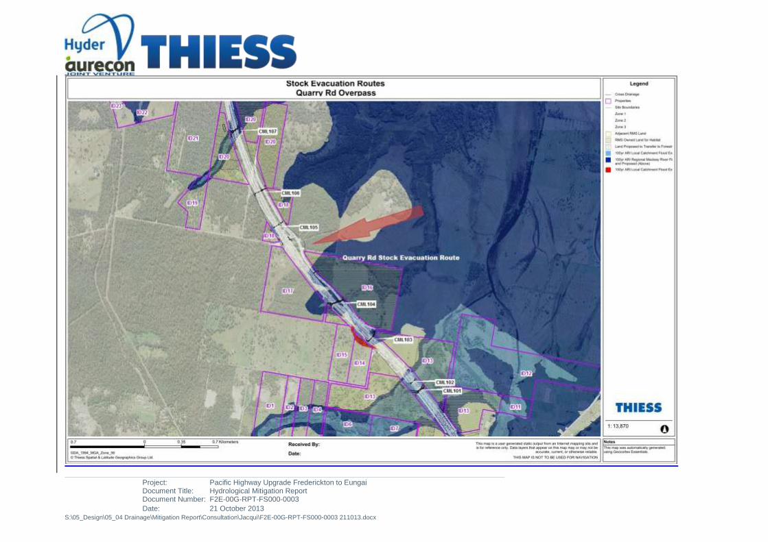
Project: Pacific Highway Upgrade Frederickton to Eungai Document Title: Hydrological Mitigation Report Document Number: F2E-00G-RPT-FS000-0003
Date: 21 October 2013 S:\05_Design\05_04 Drainage\Mitigation Report\Consultation\Jacqui\F2E-00G-RPT-FS000-0003 211013.docx

Project: Pacific Highway Upgrade Frederickton to Eungai Document Title: Hydrological Mitigation Report Document Number: F2E-00G-RPT-FS000-0003
Date: 21 October 2013 S:\05_Design\05_04 Drainage\Mitigation Report\Consultation\Jacqui\F2E-00G-RPT-FS000-0003 211013.docx

Project: Pacific Highway Upgrade Frederickton to Eungai Document Title: Hydrological Mitigation Report Document Number: F2E-00G-RPT-FS000-0003
Date: 21 October 2013 S:\05_Design\05_04 Drainage\Mitigation Report\Consultation\Jacqui\F2E-00G-RPT-FS000-0003 211013.docx

Project: Pacific Highway Upgrade Frederickton to Eungai Document Title: Hydrological Mitigation Report Document Number: F2E-00G-RPT-FS000-0003[A4]
Date: 22 October 2013 S:\05_Design\05_04 Drainage\Mitigation Report\Consultation\F2E Hydrological Mitigation Report Draft 4\F2E-00G-RPT-FS000-0003[A4].docx
APPENDIX D
FREDERICKTON TO EUNGAI BYPASS IMPACTS - DEPARTMENT OF PLANNING & INFRASTRUCTURE
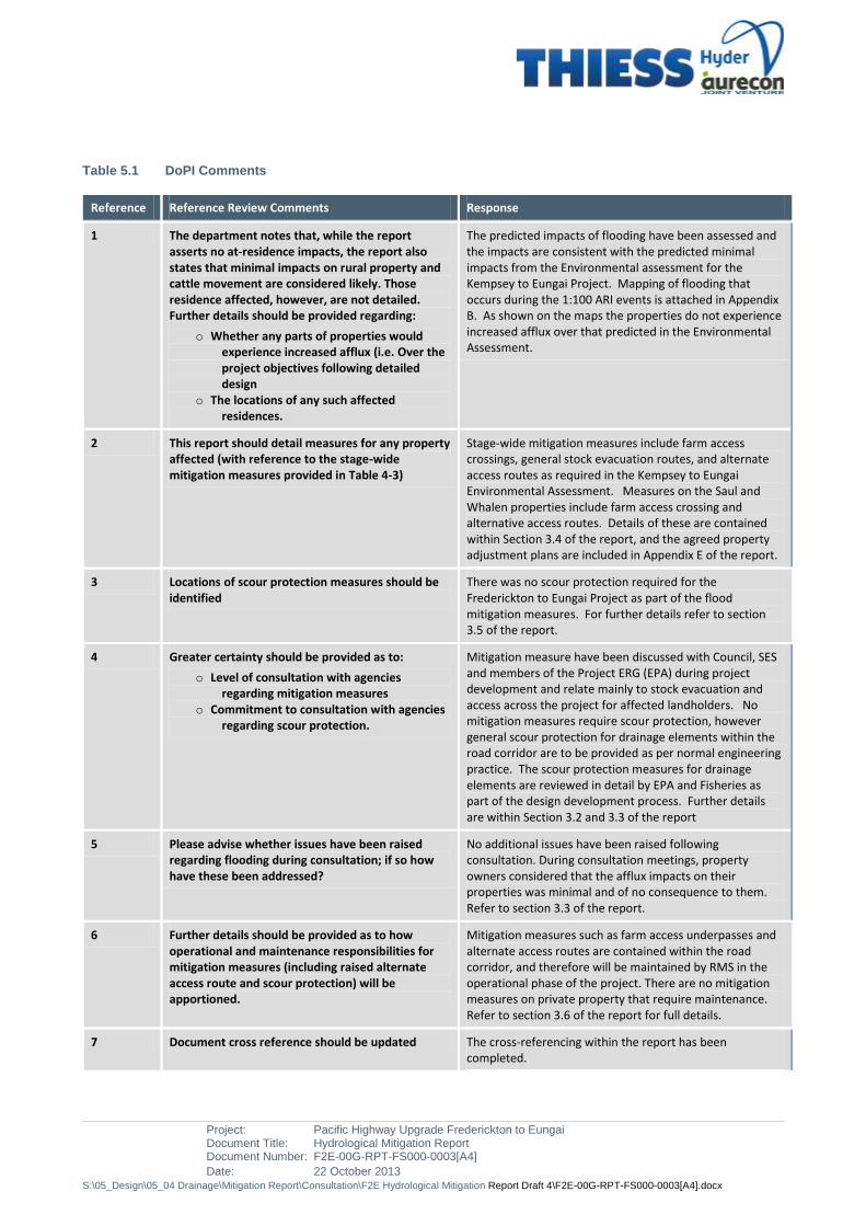
Project: Pacific Highway Upgrade Frederickton to Eungai Document Title: Hydrological Mitigation Report Document Number: F2E-00G-RPT-FS000-0003[A4]
Date: 22 October 2013 S:\05_Design\05_04 Drainage\Mitigation Report\Consultation\F2E Hydrological Mitigation Report Draft 4\F2E-00G-RPT-FS000-0003[A4].docx
Table 5.1 DoPI Comments
Reference Reference Review Comments Response
1 The department notes that, while the report asserts no at-residence impacts, the report also states that minimal impacts on rural property and cattle movement are considered likely. Those residence affected, however, are not detailed. Further details should be provided regarding:
o Whether any parts of properties would experience increased afflux (i.e. Over the project objectives following detailed design
o The locations of any such affected residences.
The predicted impacts of flooding have been assessed and the impacts are consistent with the predicted minimal impacts from the Environmental assessment for the Kempsey to Eungai Project. Mapping of flooding that occurs during the 1:100 ARI events is attached in Appendix B. As shown on the maps the properties do not experience increased afflux over that predicted in the Environmental Assessment.
2 This report should detail measures for any property affected (with reference to the stage-wide mitigation measures provided in Table 4-3)
Stage-wide mitigation measures include farm access crossings, general stock evacuation routes, and alternate access routes as required in the Kempsey to Eungai Environmental Assessment. Measures on the Saul and Whalen properties include farm access crossing and alternative access routes. Details of these are contained within Section 3.4 of the report, and the agreed property adjustment plans are included in Appendix E of the report.
3 Locations of scour protection measures should be identified
There was no scour protection required for the Frederickton to Eungai Project as part of the flood mitigation measures. For further details refer to section 3.5 of the report.
4 Greater certainty should be provided as to:
o Level of consultation with agencies regarding mitigation measures
o Commitment to consultation with agencies regarding scour protection.
Mitigation measure have been discussed with Council, SES and members of the Project ERG (EPA) during project development and relate mainly to stock evacuation and access across the project for affected landholders. No mitigation measures require scour protection, however general scour protection for drainage elements within the road corridor are to be provided as per normal engineering practice. The scour protection measures for drainage elements are reviewed in detail by EPA and Fisheries as part of the design development process. Further details are within Section 3.2 and 3.3 of the report
5 Please advise whether issues have been raised regarding flooding during consultation; if so how have these been addressed?
No additional issues have been raised following consultation. During consultation meetings, property owners considered that the afflux impacts on their properties was minimal and of no consequence to them. Refer to section 3.3 of the report.
6 Further details should be provided as to how operational and maintenance responsibilities for mitigation measures (including raised alternate access route and scour protection) will be apportioned.
Mitigation measures such as farm access underpasses and alternate access routes are contained within the road corridor, and therefore will be maintained by RMS in the operational phase of the project. There are no mitigation measures on private property that require maintenance. Refer to section 3.6 of the report for full details.
7 Document cross reference should be updated The cross-referencing within the report has been completed.

Project: Pacific Highway Upgrade Frederickton to Eungai Document Title: Hydrological Mitigation Report Document Number: F2E-00G-RPT-FS000-0003[A4]
Date: 22 October 2013 S:\05_Design\05_04 Drainage\Mitigation Report\Consultation\F2E Hydrological Mitigation Report Draft 4\F2E-00G-RPT-FS000-0003[A4].docx
APPENDIX E
FREDERICKTON TO EUNGAI BYPASS IMPACTS – CORRESPONDENCE AND OTHER CONSULTATION DETAILS

Project: Document Title:
Pacific Highway Upgrade Frederickton to Eungai Hydrological Mitigation Report
Document Number: F2E-00G-RPT-FS000-0003
Date: 21 October 2013
S:\05_Design\05_04 Drainage\Mitigation Report\Consultation\Jacqui\F2E-00G-RPT-FS000-0003 211013.docx
FW: Consultation on the hydrological impacts on forestry land due to the Frederickton to Eungai to Pacific Highway upgrade
From: * [email protected]
Sent: Wednesday, 16 October 2013 3:48
PM
To: Edwards, Greg, TPL ;
Cc:
Info:
Mail Message
Message
Greg, attached is response from Forests
NSW
Regards John
From: Jude Parr
[mailto:[email protected]]
Sent: Wednesday, 16 October 2013 3:31
PM
To: MCKECHNIE John A
Subject: RE: Consultation on the
hydrological impacts on forestry land due
to the Frederickton to Eungai to Pacific
Highway upgrade
John
I confirm my verbal advice that Forestry Corporation is aware of the proposed afflux impacts and believe there should be no significant impact on the forest estate, and we do not require a face to face meeting to

Project: Pacific Highway Upgrade Frederickton to Eungai Document Title: Hydrological Mitigation Report Document Number: F2E-00G-RPT-FS000-0004
Date: 22 October 2013 S:\05_Design\05_04 Drainage\Mitigation Report\Consultation\SS\Jacqui\F2E-00G-RPT-FS000-0004 211013.docx
further explain the impacts.
Jude Parr | Land Administration
Officer Forestry Corporation of
NSW | Central Region
Maher Street | PO Box 168 | Wauchope NSW 2447
T: 02 65869718 | F: 02 65852422| M: 0409882922
E: [email protected] | W:
www.forestrycorporation.com.au
Note change of email address From: MCKECHNIE John A
[mailto:[email protected]] Sent: Wednesday, 16
October 2013 2:17
PM
To: Jude Parr
Cc: MOORE Jeffrey
Subject: Consultation on the hydrological impacts on forestry
land due to the Frederickton to Eungai to Pacific Highway upgrade
Jude, can you confirm our recent discussion that Forestry is happy with the level of consultation that has been carried out to explain the hydrological impacts of the Pacific Highway upgrade from Frederickton to Eungai on Forestry lands.
This consultation has included:
Emails from Thiess that
have explained the impacts and included maps that show the afflux affect on Forests property.
Phone discussions that have also explained the impacts.
Can you also confirm your verbal advice that you are aware and comfortable with the proposed afflux impacts, and you do not require a face to face meeting to further explain the impacts.

Project: Pacific Highway Upgrade Frederickton to Eungai Document Title: Hydrological Mitigation Report Document Number: F2E-00G-RPT-FS000-0004
Date: 22 October 2013 S:\05_Design\05_04 Drainage\Mitigation Report\Consultation\SS\Jacqui\F2E-00G-RPT-FS000-0004 211013.docx
Regards
John McKechnie
RMS Assistant Representative- Frederickton to Eungai
Pacific Highway Upgrade Programme
Roads and Maritime Services
38 Inches Road
Verges Ck via Kempsey NSW 2440
T 02 88 746661 M 0409917223 F

Project: Pacific Highway Upgrade Frederickton to Eungai Document Title: Hydrological Mitigation Report Document Number: F2E-00G-RPT-FS000-0004
Date: 22 October 2013 S:\05_Design\05_04 Drainage\Mitigation Report\Consultation\SS\Jacqui\F2E-00G-RPT-FS000-0004 211013.docx
Other Consultations:
Kempsey Sire Council
Date: 11th October
Present:
KSC: Robert Scott, Trevor Dickson, Bruce Potts
Thiess: Greg Edwards, Monica Porte
RMS: Cameron Peace
Consultation:
Overview discussion of the impacts of the Project with respect to the Macleay River 100 ARI, Local
Catchments 100ARI
Correspondence Issued : 22nd
October 2013
Response: Pending
Summary of Impact
No additional Impact above the Environmental Assessment
Flood Impact effected by the local catchment only
o Reference to Appendix A for overall Flood impacts
o Reference to Appendix B for Stock Evacuation routes
o Reference Appendix E for Property Adjustment plans for stock movement for Saul and
Whalan -Collombatti Flood Plan
Egress for Forestry Tracks to the west available
Minor local flooding impacts in the north. All Landowners satisfied that no houses impacted
Impact shown on maps is for the 1:100 yr.( last storm event Feb 2013 was a 1:13Yr)
Smaller storms will have a smaller afflux impact
Issues raised:
Council satisfied that no additional impacts pending from project works
Nil issues raised
Project: Pacific Highway Upgrade Frederickton to Eungai Document Title: Hydrological Mitigation Report Document Number: F2E-00G-RPT-FS000-0004
Date: 22 October 2013 S:\05_Design\05_04 Drainage\Mitigation Report\Consultation\SS\Jacqui\F2E-00G-RPT-FS000-0004 211013.docx
State Emergency Services
Date: 22nd
October 2013
Present:
SES: Tony Day
Thiess: Greg Edwards, Monica Porte
RMS: John McKechnie
Consultation:
Overview discussion of the impacts of the Project with respect to the Macleay River 100 ARI, Local
Catchments 100ARI
Correspondence issued : 22nd
October 2013
Response: Pending
Summary of Impact
No additional Impact above the Environmental Assessment
Flood Impact effected by the local catchment only
o Reference to Appendix A for overall Flood impacts
o Reference to Appendix B for Stock Evacuation routes
o Reference Appendix E for Property Adjustment plans for stock movement for Saul and
Whalan -Collombatti Flood Plan
Egress for Forestry Tracks to the west available
Minor local flooding impacts in the north. All Landowners satisfied that no houses impacted
Impact shown on maps is for the 1:100 yr.( last storm event Feb 2013 was a 1:13Yr)
Smaller storms will have a smaller afflux impact
Issues raised:
SES satisfied that no additional impacts pending from project works and that SES would only be
doing minor resupply works to this area.
Nil issues raised

Project: Pacific Highway Upgrade Frederickton to Eungai Document Title: Hydrological Mitigation Report Document Number: F2E-00G-RPT-FS000-0004
Date: 22 October 2013 S:\05_Design\05_04 Drainage\Mitigation Report\Consultation\SS\Jacqui\F2E-00G-RPT-FS000-0004 211013.docx
GG & RC Saul – Property Adjustment

Project: Pacific Highway Upgrade Frederickton to Eungai Document Title: Hydrological Mitigation Report Document Number: F2E-00G-RPT-FS000-0004
Date: 22 October 2013 S:\05_Design\05_04 Drainage\Mitigation Report\Consultation\SS\Jacqui\F2E-00G-RPT-FS000-0004 211013.docx

Project: Pacific Highway Upgrade Frederickton to Eungai Document Title: Hydrological Mitigation Report Document Number: F2E-00G-RPT-FS000-0004
Date: 22 October 2013 S:\05_Design\05_04 Drainage\Mitigation Report\Consultation\SS\Jacqui\F2E-00G-RPT-FS000-0004 211013.docx

Project: Pacific Highway Upgrade Frederickton to Eungai Document Title: Hydrological Mitigation Report Document Number: F2E-00G-RPT-FS000-0004
Date: 22 October 2013 S:\05_Design\05_04 Drainage\Mitigation Report\Consultation\SS\Jacqui\F2E-00G-RPT-FS000-0004 211013.docx
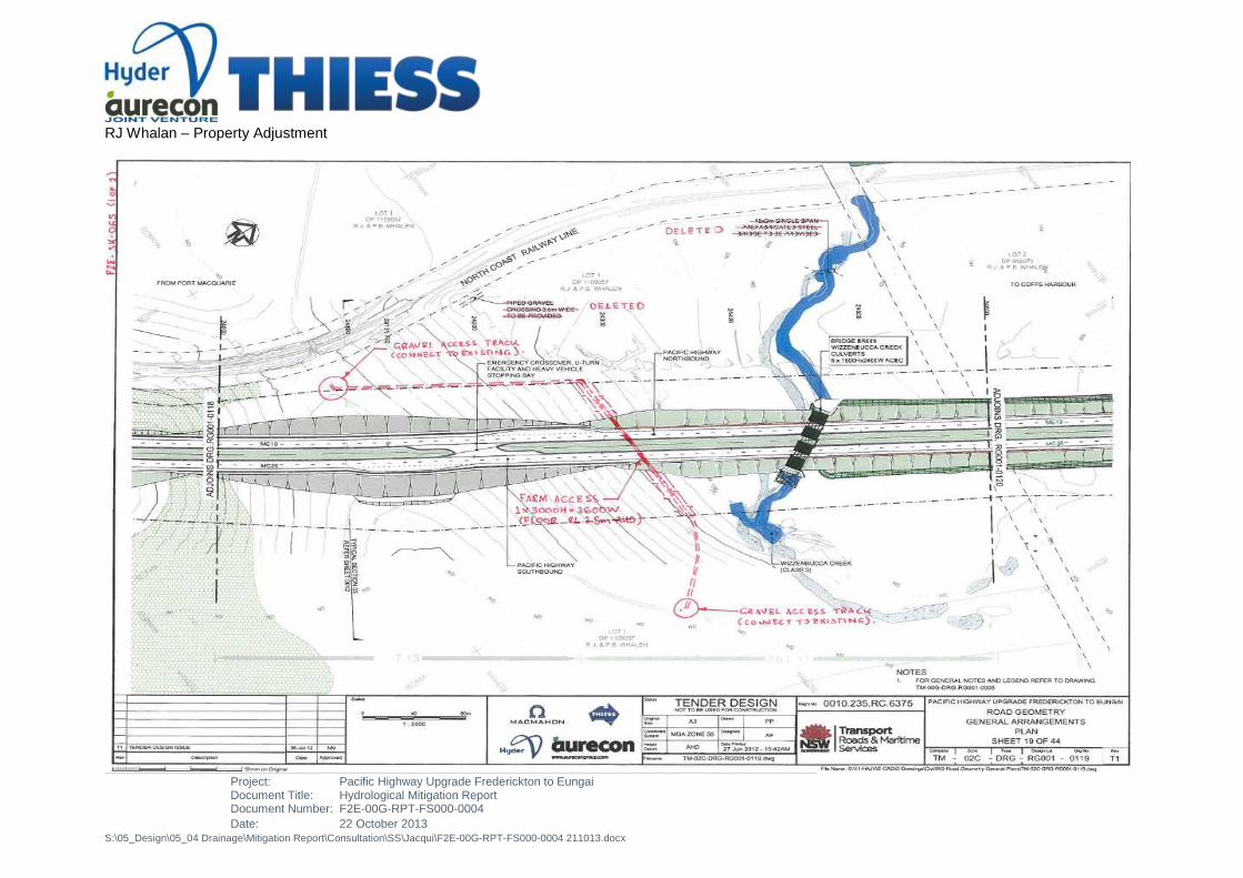
Project: Pacific Highway Upgrade Frederickton to Eungai Document Title: Hydrological Mitigation Report Document Number: F2E-00G-RPT-FS000-0004
Date: 22 October 2013 S:\05_Design\05_04 Drainage\Mitigation Report\Consultation\SS\Jacqui\F2E-00G-RPT-FS000-0004 211013.docx
RJ Whalan – Property Adjustment