pacific american coal limited - elko coal... · pacific american coal limited abn 83 127 131 604...
TRANSCRIPT
Pacific American Coal Limited ABN 83 127 131 604
Level 14, 52 Phillip Street, Sydney NSW 2000. GPO Box 3486, Sydney NSW 2001 www.pamcoal.com
PACIFIC AMERICAN COAL LIMITED (Formerly Metals Finance Limited)
MAIDEN 257.5 MILLION TONNES JORC RESOURCE
CONFIRMS COKING COAL QUALITY AT ELKO, BRITISH COLUMBIA
Initial exploration confirms 257.5 million tonne JORC Resource
3 seams identified as having hard coking coal characteristics
5 seams with thickness ranging between 2.57 metres and 5.0 metres
Open cut mine potential cashflow to fund underground operation
Additional resource potential immediately adjacent to Elko
Exploration program confirms historical activity
Planning underway for drilling program.
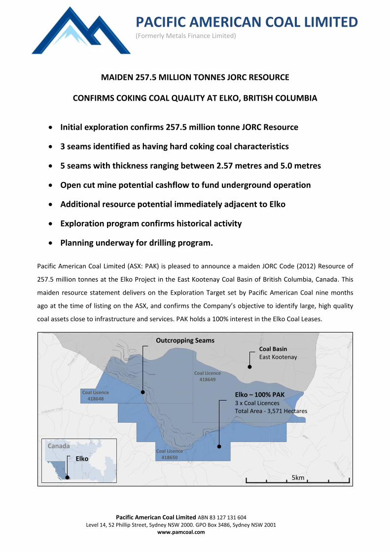
Pacific American Coal Limited (ASX: PAK) is pleased to announce a maiden JORC Code (2012) Resource of
257.5 million tonnes at the Elko Project in the East Kootenay Coal Basin of British Columbia, Canada. This
maiden resource statement delivers on the Exploration Target set by Pacific American Coal nine months
ago at the time of listing on the ASX, and confirms the Company’s objective to identify large, high quality
coal assets close to infrastructure and services. PAK holds a 100% interest in the Elko Coal Leases.
5km
Elko – 100% PAK 3 x Coal Licences Total Area - 3,571 Hectares
Outcropping Seams
Coal Basin East Kootenay
Elko
Canada
Coal Licence 418648
Coal Licence 418649
Coal Licence 418650
2
JORC Resource – 257.5 Million Tonnes
Following the completion of PAK’s initial exploration program at Elko, the Company was able to locate, log
and confirm the historical activity on and around the Elko Coal Licences. This confirmatory information was
then modelled to update the Elko geological model so as to determine a maiden, JORC compliant resource
at the Elko Project. The JORC resources consist of:
Classification
( JORC 2012 )
Resource
(million tonnes)
Inferred 181.3
Indicated 57.0
Measured 19.2
Total 257.5
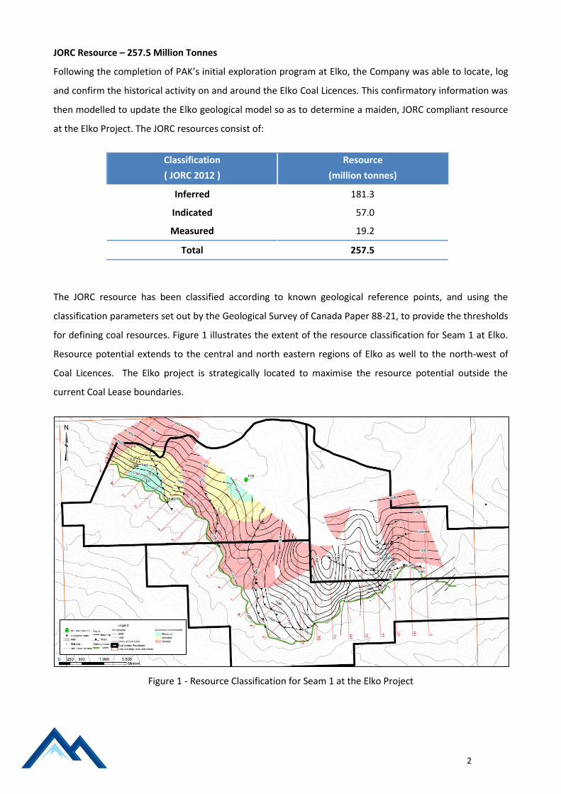
The JORC resource has been classified according to known geological reference points, and using the
classification parameters set out by the Geological Survey of Canada Paper 88-21, to provide the thresholds
for defining coal resources. Figure 1 illustrates the extent of the resource classification for Seam 1 at Elko.
Resource potential extends to the central and north eastern regions of Elko as well to the north-west of
Coal Licences. The Elko project is strategically located to maximise the resource potential outside the
current Coal Lease boundaries.
Figure 1 - Resource Classification for Seam 1 at the Elko Project

3
Coal Quality
Coal quality at Elko ranges from containing hard coking coal specifications, as reported for Seam 3 in diamond drill hole FH1, to semi hard and metallurgical PCI coal. The hard coking coal specifications for Seam 3 are reported below;
Dry Basis Clean Coal at a Float SG 1.5.
Seam Ash Volatile Matter
Fixed Carbon Free Swell
Index Sulphur
3 4.60 24.00 71.40 7.5 0.48
Table 1 – Coal quality data from diamond drill hole FH1 located in Coal Licence 418648 A subsequent drill program at the Elko Project would target coal quality and will validate coal specifications across the Elko Coal Licences.
Seam Thickness
Mineable Seam thickness across the Coal Licences ranges between 2.57m and 5.00m. This range of seam
thickness is capable of supporting underground mining methods.
Western Zone Central Zone East Zone
Seam Tonnes (000’s)
Avg Seam Thickness
(m) Seam
Tonnes (000’s)
Avg Seam Thickness
(m) Seam
Tonnes (000’s)
Avg Seam Thickness
(m)
SM7 11,350 4.13
SM5 13,418 4.44
SM5 1,131 3.12
SM4 18,852 3.76 SM4 4,335 2.57
SM3 25,168 4.23 SM3 10,037 4.75 SM3 9,589 5.00
SM1 92,812 5.00 SM1 33,769 5.00 SM1 37,093 5.00
Total 161,600 4.49 Total 48,141 4.71 Total 47,813 4.89
Sandstone roof overlaying coal
seam #4
Coal seam #4

4
Open cut potential
The raw block modelling data indicates the potential resource of an initial small scale open cut operation.
This opportunity would allow for early cash flow that would facilitate the pre-development of a larger scale
underground operation. The underground operation would target the high quality coking coal seams.
The estimated open cut resources with a strip ratio of less than 5 bcm to 1 tonne of coal is equivalent to
13.5 million tonnes.
These early open cut workings would provide geotechnical stability above the underground portals in
addition to offering a level footprint that would support locating the required mine site infrastructure.
Exploration Activity
During a 2 week period in July 2015, PAK
personnel and the Company’s consulting
geologist, Highland GeoComputing (HGC)
performed a ground truthing project across
the Elko project area. The primary objective
of this field reconnaissance was to verify the
locations of drill holes, adits, outcrops and
faults referenced in geological reports
prepared by BC Coal, Mitsui and Cline mining.
PAK and HGC were able to locate and verify
the locations of nearly every geological data
point referenced in the historical reports. As a
result, these geological data points have been
confirmed as being valid data points under
the JORC Code (2012).
Planning underway for drilling program
The next phase of exploration at Elko will focus on enhancing the coal quality and geotechnical databases
through a targeted drilling program. Planning will address the permitting requirements along with
establishing a detailed budget to achieve the Company’s objective.
Prior to commencing the drilling program the Company will seek additional sources of funding to assist in
delivering a comprehensive exploration drilling program.

5
Additional Resource Estimation Information
The following matters are included to provide a fair and balanced representation of the information
contained in the Competent Persons report. The following information provided should be read in
conjunction with Table 1 that contains a detailed summary of all key points considered by the Competent
Person in the preparation of the technical resource report.
Geology
• Target coal seams located in the Crowsnest Coal Field within the Mist Mountain Member of
the Kootenay Group. The main structure is the McEvoy Syncline where strata typically dip
20‐30 degrees to the NE or NW.
Geological Interpretation
• Drill hole data, adit data and geological mapping data were used to determined geological
cross sections across the project area
• HGC used the guidelines outlined in CGS 88-21 to define resource parameters.
• HGC divided the Elko geological model into domains bounded by faults.
• The figure below represents HGC’s interpretation of the coal seam correlations based on a
review by HGC of the available drill log and geophysical logs.
• HGC have noted that extensive additional drilling exploration will be required to
substantiate and expand the extent and quality of the Elko coal seams.

6
Sampling
• One HQ3 (61.1mm diameter) core hole located in 418648 for coal quality analyses (FH1).
• Six Adits excavated in 418648. Samples taken for coal quality analyses.
• One drill holes exist in 418649 (LP101), LP102 is adjacent to 418649
• Two adits in 418649 (LP Adit-2 and LP Adit-3)
Sub-sampling techniques
• Full coal ply were taken for analysis
• Coal samples from the adits were taken for analysis. No documentation of field sampling
procedures found.
Drilling techniques
• One vertical HQ3 core hole utilizing triple tube barrel and wireline core retrieval (FH1).
• The drill holes in 418649 used convention rotary and split tube core retrieval.
Classification Criteria
• Original map sheets using UTM NAD27 Zone 11.
• Core hole FH‐1 georeferenced from original BC Coal map sheets.
• Adit locations were digitised and georeferenced from geological and technical reports
prepared by the previous companies who conducted the exploration.
• GPS locations of drill hole FH-1 and the adits were obtained during the 2015 field
reconnaissance project.
• Adits are concentrated in the north‐west of Area 1 with irregular spacing up to 350m.
• Moderate Geology Type as per CGS Paper 88-21
Resource Classes by Data Point Distance
Measured Indicated Inferred
0 – 450m 450m – 900m 900m – 2400m
Sample Analysis Method
• Testing of core hole FH‐1 was conducted internally by B.C Coal in Sparwood, British
Columbia.
• Proximate, washability and petrographic analyses undertaken on the cores.
• Coal quality results from the adit samples were reviewed but not utilised in the estimation
due to lack of formal validation in the form of laboratory reports and certificates.
7
Estimation Methodology
• Geological cross sections of coal floor structures and faults were digitized and converted to
3-dimensional surfaces.
• Coal seam floor structures were divided into domains bounded by fault surfaces.
• Coal seam thicknesses were obtained from drill hole and adit data.
• Gridded surfaces for seam floor, seam thickness and faults were prepared in the MineScape
geological modelling and mine planning system. The grids were created using a 20 meter
grid cell size.
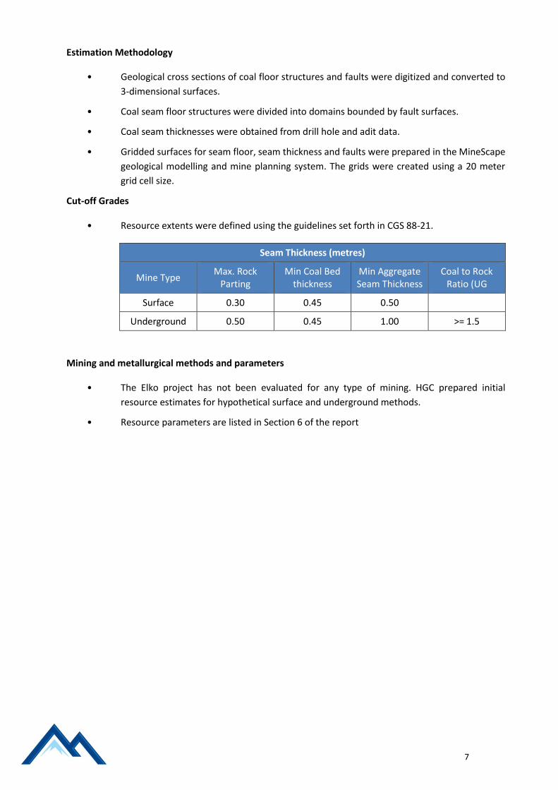
Cut-off Grades
• Resource extents were defined using the guidelines set forth in CGS 88-21.
Seam Thickness (metres)
Mine Type Max. Rock
Parting Min Coal Bed
thickness Min Aggregate Seam Thickness
Coal to Rock Ratio (UG
Surface 0.30 0.45 0.50
Underground 0.50 0.45 1.00 >= 1.5
Mining and metallurgical methods and parameters
• The Elko project has not been evaluated for any type of mining. HGC prepared initial
resource estimates for hypothetical surface and underground methods.
• Resource parameters are listed in Section 6 of the report

8
FOR FURTHER INFORMATION CONTACT:
Australia North America
Mark Sykes Dom Hill
Chief Executive Officer Business Development Manager
Pacific American Coal Ltd [email protected]
T: +61 (2) 9252 5300
More details are available on PAK‘s website www.pamcoal.com
Competent Persons Declaration COAL RESOURCES
The information in this Report that relates to Mineral Resources or Ore Reserves is based on information
compiled by Mr Dwight Kinnes who is a registered member of the Society of Mining Engineers. Mr Dwight
Kinnes is employed by Highland GeoComputing LLC. Mr Dwight Kinnes has been engaged by Pacific
American Coal Limited to prepare JORC Resource assessment for PAK. Mr Dwight Kinnes has sufficient
experience which is relevant to the style of mineralisation and type of deposit under consideration and to
the activity being undertaking to qualify as a Competent Person as defined in the 2012 Edition of the
‘Australasian Code for Reporting of Exploration Results, Mineral Resources and Ore Reserves’. Mr Dwight
Kinnes consents to the inclusion in the report of the matters based on his information in the form and
context in which it appears.”
The JORC Code provides guidelines which set out minimum standards, recommendations and guidelines for
the Public Reporting of exploration results, Mineral Resources and Ore Reserves. Within the code is a
“Checklist of Assessment and Reporting Criteria. This checklist has been used as a systematic method to
undertake the review of JORC compliance. A summary of key points are listed in Section 1, 2 and 3 (over).

9
JORC Code, 2012 Edition – Table 1: Elko Project Area – Elko, British Columbia Canada
Section 1 - Sampling Techniques and Data Criteria Elko 418648, 418649, and 418650
Criteria Elko 418648, 418649, and 418650
Sampling techniques • One HQ3 (61.1mm diameter) core hole located in 418648 for coal quality analyses (FH1).
• Six Adits excavated in 418648. Samples taken for coal quality analyses.
• One drill holes exist in 418649 (LP101), LP102 is adjacent to 418649 • Two adits in 418649 (LP Adit-2 and LP Adit-3)
Drilling techniques • One vertical HQ3 core hole utilizing triple tube barrel and wireline core retrieval (FH1).
• The drill holes in 418649 used convention rotary and split tube core retrieval.
Drill sample recovery • Core recovery recorded by geologist during logging and verified by comparing against down‐hole geophysical logs.
Logging • Drill cores were placed in core boxes and logged by a geologist. • Down‐hole wireline geophysical logging undertaken for gamma,
neutron, and density measurements. • Adits in Area 1 were mapped and seam thickness measured. • Field geological and coal outcrop mapping undertaken in Areas 2
and 3 to determine the extent and thickness of the seams.
Sub-sampling techniques and sample preparation .
• Full coal ply were taken for analysis • Coal samples from the adits were taken for analysis. No
documentation of field sampling procedures found.
Quality of assay data and laboratory tests
• Testing of core hole FH‐1 was conducted internally by B.C Coal in Sparwood,British Columbia.
• Proximate, washability and petrographic analyses undertaken on the cores.
• Coal quality results from the adit samples were reviewed but not utilised in the estimation due to lack of formal validation in the form of laboratory reports and certificates.
Verification of sampling and assaying
• High level comparison of the assay results and predictions from geophysical logs of the core hole
• Internal testing of coal core with sample ply results report.
Location of data points .
• Original map sheets using UTM NAD27 Zone 11. • Core hole FH‐1 georeferenced from original BC Coal map sheets. • Adit locations were digitised and georeferenced from geological
and technical reports prepared by the previous companies who conducted the exploration.
• GPS locations of drill hole FH-1 and the adits were obtained during the 2015 field reconnaissance project.
Data spacing and distribution • Adits are concentrated in the north‐west of Area 1 with irregular spacing up to 350m.
Orientation of data in relation to geological structure
• The cored hole was oriented vertical from the surface. • Geological and stratiform data obtained in the adits were used to
determine true seam thickness
10
Criteria Elko 418648, 418649, and 418650
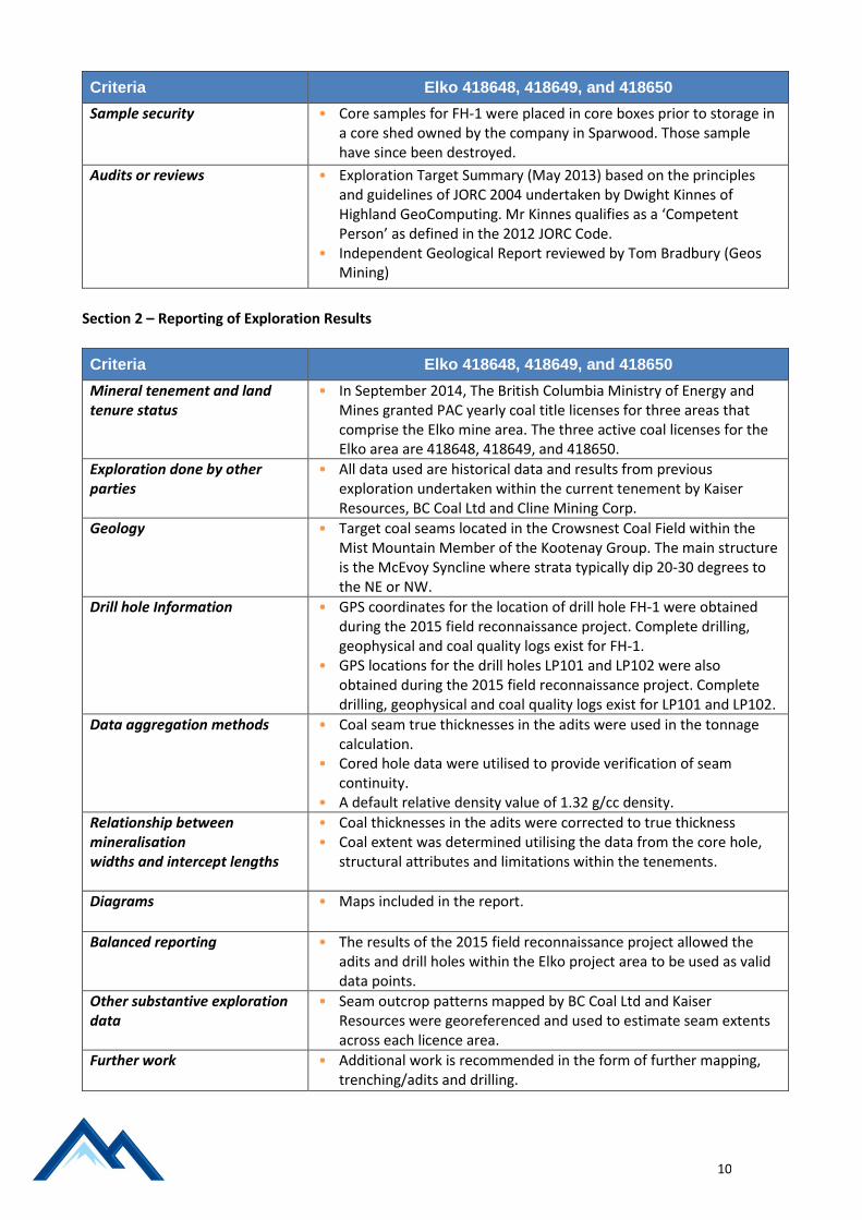
Sample security • Core samples for FH‐1 were placed in core boxes prior to storage in a core shed owned by the company in Sparwood. Those sample have since been destroyed.
Audits or reviews • Exploration Target Summary (May 2013) based on the principles and guidelines of JORC 2004 undertaken by Dwight Kinnes of Highland GeoComputing. Mr Kinnes qualifies as a ‘Competent Person’ as defined in the 2012 JORC Code.
• Independent Geological Report reviewed by Tom Bradbury (Geos Mining)
Section 2 – Reporting of Exploration Results
Criteria Elko 418648, 418649, and 418650
Mineral tenement and land tenure status
• In September 2014, The British Columbia Ministry of Energy and Mines granted PAC yearly coal title licenses for three areas that comprise the Elko mine area. The three active coal licenses for the Elko area are 418648, 418649, and 418650.
Exploration done by other parties
• All data used are historical data and results from previous exploration undertaken within the current tenement by Kaiser Resources, BC Coal Ltd and Cline Mining Corp.
Geology
• Target coal seams located in the Crowsnest Coal Field within the Mist Mountain Member of the Kootenay Group. The main structure is the McEvoy Syncline where strata typically dip 20‐30 degrees to the NE or NW.
Drill hole Information
• GPS coordinates for the location of drill hole FH-1 were obtained during the 2015 field reconnaissance project. Complete drilling, geophysical and coal quality logs exist for FH-1.
• GPS locations for the drill holes LP101 and LP102 were also obtained during the 2015 field reconnaissance project. Complete drilling, geophysical and coal quality logs exist for LP101 and LP102.
Data aggregation methods
• Coal seam true thicknesses in the adits were used in the tonnage calculation.
• Cored hole data were utilised to provide verification of seam continuity.
• A default relative density value of 1.32 g/cc density.
Relationship between mineralisation widths and intercept lengths
• Coal thicknesses in the adits were corrected to true thickness • Coal extent was determined utilising the data from the core hole,
structural attributes and limitations within the tenements.
Diagrams • Maps included in the report.
Balanced reporting
• The results of the 2015 field reconnaissance project allowed the adits and drill holes within the Elko project area to be used as valid data points.
Other substantive exploration data
• Seam outcrop patterns mapped by BC Coal Ltd and Kaiser Resources were georeferenced and used to estimate seam extents across each licence area.
Further work
• Additional work is recommended in the form of further mapping, trenching/adits and drilling.
11
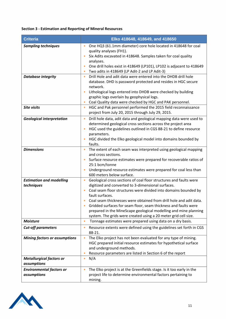
Section 3 - Estimation and Reporting of Mineral Resources Criteria Elko 418648, 418649, and 418650
Criteria Elko 418648, 418649, and 418650
Sampling techniques • One HQ3 (61.1mm diameter) core hole located in 418648 for coal quality analyses (FH1).
• Six Adits excavated in 418648. Samples taken for coal quality analyses.
• One drill holes exist in 418649 (LP101), LP102 is adjacent to 418649 • Two adits in 418649 (LP Adit-2 and LP Adit-3)
Database integrity
• Drill Hole and adit data were entered into the DHDB drill hole database. DHD is password protected and resides in HGC secure network.
• Lithological logs entered into DHDB were checked by building graphic logs overlain by geophysical logs.
• Coal Quality data were checked by HGC and PAK personnel.
Site visits
• HGC and Pak personnel performed the 2015 field reconnaissance project from July 20, 2015 through July 29, 2015.
Geological interpretation
• Drill hole data, adit data and geological mapping data were used to determined geological cross sections across the project area
• HGC used the guidelines outlined in CGS 88-21 to define resource parameters.
• HGC divided the Elko geological model into domains bounded by faults.
Dimensions
• The extent of each seam was interpreted using geological mapping and cross sections.
• Surface resource estimates were prepared for recoverable ratios of 25:1 bcm/tonne
• Underground resource estimates were prepared for coal less than 600 meters below surface.
Estimation and modelling techniques
• Geological cross sections of coal floor structures and faults were digitized and converted to 3-dimensional surfaces.
• Coal seam floor structures were divided into domains bounded by fault surfaces.
• Coal seam thicknesses were obtained from drill hole and adit data. • Gridded surfaces for seam floor, seam thickness and faults were
prepared in the MineScape geological modelling and mine planning system. The grids were created using a 20 meter grid cell size.
Moisture • Tonnage estimates were prepared using data on a dry basis.
Cut-off parameters • Resource extents were defined using the guidelines set forth in CGS 88-21.
Mining factors or assumptions
• The Elko project has not been evaluated for any type of mining. HGC prepared initial resource estimates for hypothetical surface and underground methods.
• Resource parameters are listed in Section 6 of the report
Metallurgical factors or assumptions
• N/A
Environmental factors or assumptions
• The Elko project is at the Greenfields stage. Is it too early in the project life to determine environmental factors pertaining to mining.

12
Criteria Elko 418648, 418649, and 418650
Bulk density • An in-situ coal density of 1.32 g/cc was applied during resource estimation.
Classification
• HGC used guidelines set forth in CGS 88-21 to determine resources confidence categories.
• Too little data exists to perform any type of geostatistical analysis. • The mineral resource classes do reflect Dwight Kinnes’ view of the
deposit.
Audits or reviews
• This report present the preliminary resource estimates for the Elko project. No audits have been performed.
Discussion of relative accuracy/ confidence
• Too little data exists to perform any type of geostatistical analysis. • The 2015 field reconnaissance project improved the confidence in
all of the historic geological because all of the data points were located precisely were the historical data showed.
• Historical mapping data also matched field mapping data collected by HGC.
• HGC limited resource estimates to drill hole and adit data. Outcrop mapping indicates that the coal seams extend across the project area, but the outcrop mapping cannot currently be used for resource estimation.
.