oweninny wind farm - wordpress.com · hydro-geological investigations ... (in relation to the...
TRANSCRIPT
Copyright © ESB International Limited, all rights reserved.
Oweninny Wind Farm
Oweninny Bellacorick Iron Flush
Appendix 14
Natura Impact Statement (SCREENING)

Farm

Oweninny Wind Energy Project Environmental Impact Statement County Mayo May 2013
APPENDIX A.
SCREENING
Ballacorick Iron Flush Appendix 14A

Farm

OWENINNY WINDFARM PROPOSAL
BELLACORICK IRON FLUSH
HYDRO-GEOLOGICAL INVESTIGATIONS
NATURA IMPACT STATEMENT
‘SCREENING’
Prepared for
ESB International
by
Biosphere Environmental Services
29 La Touche Park, Greystones, Co. Wicklow
Tel: 01-2875249 E-mail: [email protected]

Bellacorick Iron Flush Hydro-geological Survey Natura Impact Statement: Screening
ESB International Biosphere Environmental Services
ii
TABLE OF CONTENTS
1. INTRODUCTION........................................................................................................................1
1.1 Background..........................................................................................................................1
1.2 Regulatory Context .............................................................................................................1
1.3 Stages of the Appropriate Assessment (AA) ..................................................................2
2. SCREENING FOR APPROPRIATE ASSESSMENT ...........................................................3
2.1 Description of the Project...................................................................................................3
2.1.1 Purpose & scope ....................................................................................................................3
2.1.2 Background .............................................................................................................................4
2.1.3 Site sensitivity mapping & protection ..................................................................................4
2.1.4 Site walkover survey & drainage mapping & hydrochemistry mapping .........................5
2.1.5 Peat morphology & substrate mapping...............................................................................5
2.1.6 Window sampling & piezometer installation.......................................................................6
2.1.7 Topographical survey ............................................................................................................8
2.1.8 Sampling & on-going monitoring..........................................................................................9
2.2 Sites Identification.............................................................................................................10
2.2.1 Bellacorick Iron Flush candidate Special Area of Conservation................................11
2.3 Identification and Assessment of Potential Impacts on Bellacorick Iron Flush cSAC
............................................................................................................................................11
2.3.1 Impacts by personnel on site ..........................................................................................12
2.3.2 Impacts by intrusive works on site .................................................................................12
2.4 Analysis of “In-combination” Effects...............................................................................13
2.5 Screening Conclusion and Statement ...........................................................................14
2.6 References.........................................................................................................................15
APPENDIX 1 : Site Synopsis
Figure 1: Bellacorick Iron Flush cSAC : Proposed Investigation Map

1. INTRODUCTION
1.1 Background
This report has been prepared by Dr. Brian Madden of BioSphere Environmental
Services, in association with ESB International and Hydro Environmental Services to
determine the potential impacts, if any, of the plan for a hydro-geological
investigation (in relation to the Oweninny Wind Farm project) at the Bellacorick Iron
Flush candidate Special Area of Conservation. The assessment will determine the
appropriateness, or otherwise, of the proposed project in the context of the
conservation objectives of the site.
The purpose of the proposed study is to determine the potential for impact on the
hydro-geology of the fen which could arise from the proposed construction of wind
turbine foundations in its vicinity.
The assessment is in support of an application to the Department of Arts, Heritage
and the Gaeltacht for permission to carry out an operation or activity on a site to
which the European Communities (Natural Habitats) Regulations 1997 (No. 94 of
1997) as amended, apply, in accordance with Regulation 14 of those Regulations.
1.2 Regulatory Context
The Council Directive 92/43/EEC on the Conservation of Natural Habitats and of Wild
Flora and Fauna better known as “The Habitats Directive” provides the framework for
legal protection for habitats and species of European importance. Articles 3 to 9
provide the legislative means to protect habitats and species of Community interest
through the establishment and conservation of an EU-wide network of sites known as
Natura 2000. These are Special Areas of Conservation (SACs) designated under the
Habitats Directive and Special Protection Areas (SPAs) designated under the
Conservation of Wild Birds Directive (79/409/EEC) (better known as “The Birds
Directive”).
Article 6(3) and 6(4) of the Habitats Directive set out the decision-making tests for
plans and projects likely to affect Natura 2000 sites (Annex 1.1). Article 6(3)
establishes the requirement for Appropriate Assessment (now termed Natura Impact
Statement):
“Any plan or project not directly connected with or necessary to the
management of the [Natura 2000] site but likely to have a significant effect
thereon, either individually or in combination with other plans and projects,
shall be subjected to appropriate assessment of its implications for the site in
view of the site’s conservation objectives. In light of the conclusions of the
assessment of the implication for the site and subject to the provisions of

Bellacorick Iron Flush Hydro-geological Survey Natura Impact Statement: Screening
ESB International Biosphere Environmental Services
2
paragraph 4, the competent national authorities shall agree to the plan or
project only after having ascertained that it will not adversely affect the
integrity of the site concerned and, if appropriate, after having obtained the
opinion of the general public”
The Habitats Directive promotes a hierarchy of avoidance, mitigation and
compensatory measures. First the project should aim to avoid any negative impacts
on European sites by identifying possible impacts early in the planning stage, and
designing the project in order to avoid such impacts. Second, mitigation measures
should be applied, if necessary, during the AA process to the point, where no
adverse impacts on the site(s) remain. If the project is still likely to result in adverse
effects, and no further practicable mitigation is possible, then it is rejected. If no
alternative solutions are identified and the project is required for imperative reasons
of overriding public interest (IROPI test) under Article 6 (4) of the Habitats Directive,
then compensation measures are required for any remaining adverse effect.
1.3 Stages of the Appropriate Assessment (AA)
This Natura Impact Statement has been undertaken in accordance with the
European Commission Methodological Guidance on the provision of Article 6(3) and
6(4) of the ‘Habitats’ Directive 92/43/EEC (EC 2001) and the European Commission
Guidance ‘Managing Natura 2000 Sites’. The Guidance for Planning Authorities
issued by the Department of Environment, Heritage and Local Government
(December 2009) is also adhered to.
There are four distinct stages to undertaking an AA as outlined in current EU and
DOEHLG guidance:
1. Appropriate Assessment Screening
2. Appropriate Assessment
3. Assessment of Alternatives in cases where significant impact cannot be
prevented
4. Where no alternatives exist, an assessment of compensatory issues in the case
of projects or plans which can be considered to be necessary for imperative
reasons of overriding public interest (IROPI)

Bellacorick Iron Flush Hydro-geological Survey Natura Impact Statement: Screening
ESB International Biosphere Environmental Services
3
2. SCREENING FOR APPROPRIATE ASSESSMENT
Screening determines whether appropriate assessment is necessary by examining:
1. Whether a plan or project can be excluded from AA requirements because it is
directly connected with or necessary to the management of a Natura 2000 site.
2. Whether the project will have a potentially significant effect on a Natura 2000 site,
either alone or in combination with other projects or plans, in view of the site’s
conservation objectives.
Screening involves the following:
i. Description of plan or project
ii. Identification of relevant Natura 2000 sites, and compilation of
information on their qualifying interests and conservation objectives
iii. Assessment of likely effects – direct, indirect and cumulative –
undertaken on the basis of available information as a desk study or
field survey or primary research as necessary
iv. Screening Statement with conclusions
2.1 Description of the Project
There follows a detailed method statement for the work required for the proposed
project.
2.1.1 Purpose & scope
The Bellacorick Iron Flush cSAC is located within the Bord na Mona former peat
harvesting site at Oweninny in County Mayo. Bord na Mona in a joint venture with
ESB Wind Development intend to apply for planning permission for a substitute wind
farm development on the site. The Bellacorick Iron Flush cSAC, which is in the
ownership of An Taisce and the National Parks and Wildlife Services, was identified
as a very sensitive area requiring special consideration and a specific study relating
to the hydrology of the site. The proposed study will entail groundwater level
measurement within and around the site and sampling for hydrochemistry.

Bellacorick Iron Flush Hydro-geological Survey Natura Impact Statement: Screening
ESB International Biosphere Environmental Services
4
The following defines the methods, equipment and procedures for the undertaking of
a Phase 1 and Phase 2 site investigation at Bellacorick Iron Flush cSAC. A
preliminary site visit and report was previously undertaken by Hydro Environmental
Services (HES) which included a desk study and initial characterisation of the cSAC.
The preliminary report was based on a walkover survey (outside the perimeter of the
cSAC) and existing information.
2.1.2 Background
It is proposed that the Phase 1 investigation will comprise the following elements.
The procedures are discussed in detail below.
• Site walkover survey and drainage mapping;
• Hydrochemistry mapping;
• Peat morphology and substrate survey;
It is proposed that the Phase 2 investigation will comprise the following elements.
• Window sampling and piezometer installation;
• Topographic survey; and,
• Sampling & on-going Monitoring.
2.1.3 Site sensitivity mapping & protection
Prior to any investigation works taking place, there will be an updated ecological
survey of the cSAC undertaken by an ecologist. This will focus on the wet grassland
and fen/flush zones of the site, with particular emphasis on the distribution of Marsh
Saxifrage. Further, the ecologist will be present on-site to oversee all investigation
works. (Oweninny Power Ltd have appointed BioSphere Environmental Services as
project ecologists, with Dr John Conaghan acting as principal ecologist for this
project)
The ecological survey will delineate sensitive areas of the cSAC and areas that
should be completely avoided during the investigation works. It is anticipated that the
core wet grassland area which supports the main population of Marsh Saxifrage will
be an exclusion zone. Also, to minimise impacts on vegetation and blanket bog,
walking routes to and from proposed investigation areas within the cSAC boundary
will be pre-marked by the ecologist. The sensitive areas and dedicated walking
routes will be marked using bamboo canes with tape strands and/or tape strands
attached to clumps of vegetation. Other measures to reduce impacts on the cSAC
include:
• No peat digging or extraction outside of selected investigation areas;
• All investigation areas will be reinstated after works are completed and inspected
by ecologist;

Bellacorick Iron Flush Hydro-geological Survey Natura Impact Statement: Screening
ESB International Biosphere Environmental Services
5
• Use of automatic data loggers to reduce the need to return to the site frequently
to undertake manual monitoring;
• Refuelling of generator will be undertaken outside of cSAC boundary;
• The generator will be placed on a drip tray during use;
• Spill kits will be available in case of accidentals spills;
• Good house keeping practices; and,
• No disposal of waste (liquid or solid) will be allowed.
2.1.4 Site walkover survey & drainage mapping & hydrochemistry mapping
Resources and Equipment
• 1 no. HES site staff and 1 no. ecologist;
• YSI multi-meter hand held hydrochemistry probe;
• Hand held GPS;
• Camera; and,
• Required working area approximately 1m2
Procedure
A walkover survey of the cSAC and the surrounding area will be undertaken which
will include mapping of drainage features, flow directions and principal discharge
zones. Field hydrochemistry measurements (electrical conductivity, pH, temperature
& DO) of drain water and any flushes (with mineral rich groundwater) will be
undertaken to determine the origin of flows and seepages. Hydrochemistry
measurements will be undertaken using a handheld YSI Multi-meter probe.
Locations of measurement points will be recorded by means of a hand held GPS.
Walking routes within the cSAC will be advised by the ecologist.
2.1.5 Peat morphology & substrate mapping
Resources and Equipment
• 1 no. HES site staff and 1 no. ecologist;
• 1m length plastic peat probes;
• Hand held steel gouge auger set (see Plate A);
• Hand held GPS;
• Camera; and,
• Required working area approximately 1m2.

Bellacorick Iron Flush Hydro-geological Survey Natura Impact Statement: Screening
ESB International Biosphere Environmental Services
6
Plate A. Standard Gouge Auger Set.
Procedure
Characterisation of peat and subsoil morphological conditions within the cSAC will be
undertaken by carrying out peat depth probing and gouge augering. Peat depth
probing, by means of push in plastic Rods (20mm diameter), will be undertaken at a
25m grid spacing which can be reduced or increased depending on the
geomorphology of the bog. It is expected that between no. 20 – 30 peat probes will
be undertaken. It is expected that between no. 10 – 20 gouge cores will be
undertaken.
Gouge augers are steel cylindrical chambers (30mm diameter) which are pushed into
the peat/subsoil, twisted and then recovered to display a full and virtually undisturbed
profile of the peat and underlying mineral subsoil (where present). Peat and subsoil
profile logging will be undertaken as per Von Post Scale & BS5930. Locations of
probe points will be recorded by means of a hand held GPS. Walking routes and
peat probe locations between probe locations will be advised by the ecologist.
The holes created by the peat probe and gouge cores will only exist temporarily as
the hole will collapse and the hole will reseal itself.
2.1.6 Window sampling & piezometer installation
Resources & Equipment
• 2 no. HES site staff and 1 no. ecologist;
• Hydraulic hammer & power packr (Plate B shows a picture of the hammer and
power pack). It weighs 72kg, and has approximately dimensions of 74x62x55cm);
• Steel driving rods (0.5m & 1m lengths) & steel window sampler tubes (1m & 2m
lengths);

Bellacorick Iron Flush Hydro-geological Survey Natura Impact Statement: Screening
ESB International Biosphere Environmental Services
7
• Window sampler mechanical jack & hoist bars (the jack is 30x30cm, and the bars
are 2.0m box steel, see Plate C);
• 18mm x 3m plastic piezometer lengths;
• Bentonite clay & sand;
• General tools; and,
• Required working area approximately 3m2
Plate B. Hydraulic Power Pack & Hammer Plate C. Jack and hoist bars (green)
Procedure
A network of nested piezometers for groundwater level monitoring will then be
installed within the cSAC and at its boundaries by means of window sampling (see
steps below) which is a technique that uses portable coring equipment to recover
narrow cores of peat and subsoil for visual logging and sampling. Nested
piezometers are a group of piezometers installed at different depths to measure
vertical water level gradients within the peat (i.e. phreatic surface & deep peat). The
procedure will include the following steps.
• Site staff to locate drill target by means of GPS or otherwise;
• Mobilise equipment to drill target manually;
• Adhere to walking paths and drill locations set by the ecologist;
• Window sampling tubes are then driven into ground by means of hydraulic
hammer;
• Once the sampling tube has reached its maximum depth below ground level the
tube is withdrawn by a mechanical jack & hoist bars;
• Window sampler tube is then laid out on ground and logged by site staff;
• Subsoil samples are taken and are placed into clearly marked containers;
• The remainder of the subsoil material is removed from the window sampler and
kept in waste disposal bag and removed from the site;

Bellacorick Iron Flush Hydro-geological Survey Natura Impact Statement: Screening
ESB International Biosphere Environmental Services
8
• The process is repeated until the required depth is reached or until refusal is
met;
• Piezometers tubes are installed once the required depth is reached;
• Drill target site is cleared and equipment is moved to next drill target as required.
In relation to deep subsoil piezometers installation the following construction method
is proposed:
• Create hole in peat down to subsoil level by using gouge core;
• 3” PVC well casing is then pushed down manually through hole in peat and into
underlying mineral subsoil where a seal between the casing and clay is created;
• Peat remains from inside the 3” PVC well casing are then removed by means of
bailer;
• Drill on into underlying mineral subsoil layer by using window sampler method;
• Install minimum diameter 19mm piezometer down to maximum depth of hole;
• Install bentonite seal across the subsoil and peat interval to remove the
possibility of puncturing hole in any natural aquitard layer;
• Fill the remainder of the hole back to ground level with peat.
The above method was specifically designed to re-create a seal between the peat
and mineral subsoil layer after the installation of the piezometer. This removes any
potential for upwelling of mineral subsoil groundwater or downward movement of
peat water. The natural balance of water migration between the peat and subsoil will
not be altered as a result of the piezometer been present.
The proposed numbers of peat piezometers and subsoil piezometers are shown in
Table 1 below. The proposed locations are shown Figure 1.
The below numbers and locations may change depending on the Phase 1
investigation and ecological survey.
Table 1: Proposed numbers of installations
Installation
Type
No.
Shallow
peat
12
Deep peat 12
Subsoil 6
2.1.7 Topographical survey
Resources & Equipment
• 1 no. HES site staff and 1 no. ecologist;

Bellacorick Iron Flush Hydro-geological Survey Natura Impact Statement: Screening
ESB International Biosphere Environmental Services
9
• Handheld dGPS rover staff; and,
• Required working area approximately 1m2
Procedure
A topographic survey of the cSAC and surrounding area will be undertaken which will
include drains, water levels, intact bog and cutaway areas. The survey will be
undertaken in OSI national grid based on GPS static survey and to OSI GPS Datum
at Malin Head.
2.1.8 Sampling & on-going monitoring
Resources & Equipment
• 1 no. HES site staff;
• Automatic water level loggers;
• Handheld water level dipper;
• YSI Multi-meter handheld hydrochemistry probe;
• 1 litre Sample bottles;
• Handheld purge device; and,
• Required working area approximately 1m2
Procedure
Two rounds of peat water and groundwater sampling will be undertaken from
selected piezometer locations within the cSAC flush. Sampling will require visiting
each of the piezometer locations and purging less than 1 litre of groundwater / peat
water for removal off-site.
On-going groundwater level monitoring will need to be made as this will be a critical
element of the overall understanding of the cSAC flush. The monitoring will involve
visiting each of the piezometer locations within the cSAC to measure water levels.
Measurements will be undertaken using a handheld dipping device. It is proposed
that monthly water levels will be undertaken by HES or a trained Bord na Mona staff
member.
Automatic in well water level dataloggers are to be used where possible to reduce
the number of visits to the site. These are 22mm diameter and can be inserted into
each of the monitoring wells. These should be downloaded at least once every 6
months.

Bellacorick Iron Flush Hydro-geological Survey Natura Impact Statement: Screening
ESB International Biosphere Environmental Services
10
2.2 Sites Identification
In accordance with the European Commission Methodological Guidance (EC2001), a
list of European sites that can be potentially affected by the project has been
compiled. While there are several European sites within a radius of 10 km of the iron
flush, the focused nature of the project will essentially affect only the iron flush.
However, for completeness the other European sites are listed
Bellacorick Iron Flush candidate Special Area of Conservation (code 0466)
This small site is within the Oweninny cutover bogs. It is a small minerotrophic fen
developed on glacial till overlying calcareous sandstone. The site supports several
rare and protected plant species, notably marsh saxifrage. (see below and Appendix
1 for full details)
Bellacorick Bog Complex candidate Special Area of Conservation (code 01922)
This is a large blanket bog site with some of the best examples of lowland blanket
bog in the country and a particularly well developed pool system. The site includes
the Knockmoyle Sheskin Nature Reserve.
Lough Dahybaun candidate Special Area of Conservation (code 02177)
This lake is a good example of an oligotrophic lake surrounded by blanket bog. It
supports the rare and protected plant Slender Naiad.
Owenduff/Nephin Complex candidate Special Area of Conservation (code 0534)
and Special Protection Area (code 04098)
This very large site extends from south-east of Bellacorick to include the entire
Nephin Beg range. It is an excellent example of a peatland landscape, with
extensive blanket bog and wet heath. The site is an important bird site, with
populations of the following Annex I species: Greenland White-fronted Geese, Merlin,
Peregrine and Golden Plover.
Taking into account the distance of the location of the works at the iron flush from the
Bellacorick Bog Complex SAC, the Lough Dahybaun SAC and the Owenduff/Nephin
Complex SAC/SPA, it can be concluded that the proposed works at the flush could
have no impacts on these sites and hence these are excluded from further
assessment.

Bellacorick Iron Flush Hydro-geological Survey Natura Impact Statement: Screening
ESB International Biosphere Environmental Services
11
2.2.1 Bellacorick Iron Flush candidate Special Area of Conservation
Bellacorick Iron Flush is one of only eight recorded stations for the very rare species,
Marsh Saxifrage, in Ireland. All of these locations are within a 10 km radius of the
Iron Flush. The habitat in which it is found is typical for the species, though the
ground is drier than on other locations. This fen is surrounded by extensive areas of
commercially cut peat and drains that have caused a lowering of the water table,
resulting in the loss of vegetation associated with wetter areas that was described in
earlier references to the site by King and Scannell (1960). Some of the typical fen
species that were present are now absent or scarce (notably the rare mosses
Homalothecium nitens and Meesia triquetra) and the vegetation shows trends
towards drier, more acidic species. Without further studies, it is unknown if the
drying out of the flush and the lack of grazing will effect the survival of the species.
Despite this the flush is still considered of high conservation value for Marsh
Saxifrage.
SAC Qualifying Interests
The SAC has been selected for the following Annex II species:
• Marsh saxifrage (Saxifraga hirculus) [1528]
SAC Conservation Objectives
The NPWS Conservation Statement (2009) for the Bellacorick Iron Flush cSAC gives
the conservation objectives for the site as follows:
Objective 1: To maintain the Annex II species for which the cSAC has been selected
at favourable conservation status; Marsh Saxifrage
Objective 2: To maintain the extent, species richness and biodiversity of the entire
site
Objective 3: To establish effective liaison and co-operation with landowners, legal
users and relevant authorities.
2.3 Identification and Assessment of Potential Impacts on Bellacorick
Iron Flush cSAC
The method statement details all stages of required work for the proposed project.
Possible impacts on the conservation objectives for the SAC are considered in the
following, along with the measures which will be taken to alleviate or minimise any
such impacts.

Bellacorick Iron Flush Hydro-geological Survey Natura Impact Statement: Screening
ESB International Biosphere Environmental Services
12
2.3.1 Impacts by personnel on site
The various stages of work will require incursions over the site to carry out surveys
and to reach investigation locations. Most of the stages will involve a single person
from HES accompanied by an ecologist, though the window sampling and
piezometer installation work will require two persons from HES. The initial
ecological survey will be carried out by a single ecologist. It is anticipated that the
ongoing monitoring will be carried out by a single HES person or by a trained Bord na
Mona staff member (route to be used will be pre-determined by the ecologist).
While incursions over sensitive wetland habitats are always undesirable, in this case
the incursions will be in a controlled setting and will be under the supervision of an
experienced wetland ecologist. The most sensitive habitat area, mainly the core
wet grassland where Marsh Saxifrage occurs, will be largely avoided.
Taking into account the temporary nature of the works and the controlled manner in
which they will be conducted, it is considered that the conservations objectives for
the SAC will not be adversely affected.
2.3.2 Impacts by intrusive works on site
The nature of the project requires various intrusive sampling for peat, subsoil and
ground water.
For the Phase 1 investigations it is expected that between no. 20-30 peat probes will
be undertaken and between no. 10-20 gouge core. The holes created by the peat
probe and gouge cores will only exist temporarily as the hole will collapse and reseal
itself.
For the Phase 2 investigations it is expected that there will be in the region of no. 12
shallow peat installations, no. 12 deep peat installations and no. 6 subsoil
installations (exact numbers are dependent on Phase 1 findings).
The method designed for the deep subsoil piezometers will re-create a seal between
the peat and mineral subsoil layer after the installation of the piezometer. This
removes any potential for upwelling of mineral subsoil groundwater or downward
movement of peat water. Therefore the natural balance of water migration between
the peat and subsoil will not be altered as a result of the piezometer been present.
As these proposed works are highly localised on site and will be carried out under
supervision so as to avoid areas where Marsh Saxifrage grows, and taking into
account that the natural water balance of the system will not be affected, it is

Bellacorick Iron Flush Hydro-geological Survey Natura Impact Statement: Screening
ESB International Biosphere Environmental Services
13
considered that the conservations objectives for the SAC will not be adversely
affected.
2.4 Analysis of “In-combination” Effects
The Habitats Directive requires competent authorities to make an appropriate
assessment of any plan or project which is likely to have a significant effect alone or
in-combination with other plans and projects.
The following projects or landuses are considered in the context of possible in-
combination effects on the Bellacorick Iron Flush cSAC. It is noted that the main
landuse of the site is nature conservation, with the entire SAC being in the ownership
of An Taisce and NPWS.
Agriculture
The site would have formerly been grazed and nowadays low numbers of cattle and
sheep trespass onto the site. The Conservation Statement for the site considers
notes that undergrazing is a potential problem, as it can allow competing plant
species to dominate, leading to overall reduction in species richness.
Drainage
It is considered that the fen habitat has probably been drying out since 1950, with
many former species indicative of wet conditions now absent. The drainage has
occurred as a result of the commercial harvesting of the adjoining peat bogs.
Wind farms
A wind farm development has planning permission in the Oweninny cut bog areas
surrounding the fen. The NPWS Conservation Statement notes that this
development could have an impact on groundwater in the associated flush area, due
to deep excavation and pile-driving during construction and post-construction drying
out. It is noted further that a hydro-geological assessment of the wind farm site and
flush area, carried out before development takes place, could determine the quality,
quantity and sources of water feeding the SAC.
An existing wind farm built in 1992 occurs to the south-west of the fen, within a
distance of about 2.0 kilometres.

Bellacorick Iron Flush Hydro-geological Survey Natura Impact Statement: Screening
ESB International Biosphere Environmental Services
14
In-combination effects conclusion
Nowadays, nature conservation is the only landuse associated with the Bellacorick
Iron Flush cSAC, with NPWS committed to scientific monitoring and site surveillance.
However, the site is considered to be still affected by drainage from past harvesting
of surrounding bogs and is likely to be in long-term hydrological decline.
The NPWS Conservation Statement for the site notes that the permitted wind farm
could have an impact on groundwater in the associated flush area, and that a hydro-
geological assessment of the wind farm site and flush area, carried out before
development takes place, could determine the quality, quantity and sources of water
feeding the SAC.
Due to the sensitive approach being adopted for the present project, especially the
close supervision by an ecologist throughout, it is considered that the proposal will
not adversely affect the conservation objectives of the SAC and hence would not
contribute to the principal adverse factor presently affecting the site, namely the long-
term effects of drainage. In fact, the project will contribute positively to the
understanding of the complex hydrology of the site.
2.5 Screening Conclusion and Statement
The screening process has examined the details of the proposed project and has
considered the conservation objectives of the relevant European site, namely the
Bellacorick Iron Flush cSAC.
It is concluded that the project, alone or in-combination with other projects or
landuses, will not have any direct or indirect impacts on the conservation objectives
of the cSAC. In fact, the findings from the project will contribute positively to the
understanding of the hydrology of the site, which is essential for its long-term
management. .
Accordingly, progression to Stage 2 of the Natura Impact Statement process is not
considered necessary.

Bellacorick Iron Flush Hydro-geological Survey Natura Impact Statement: Screening
ESB International Biosphere Environmental Services
15
2.6 References
Department of Environment, Heritage & Local Government, Dublin. Conservation
Statement 2009 for Bellacorick Iron Flush cSAC. Site Code 466, Co. Mayo.
Department of the Environment, Heritage & Local Government (2011). Protected
sites in County Mayo - listings and maps. See www.npws.ie
European Commission (1996). Interpretation Manual of European Union Habitats.
Version Eur 15. European Commission, DG XI.
Fojt, W. (1988) Bellacorcik Iron Flush, Co Mayo. In: Mires Research Group. Field
Excursion, Ireland, 1988 (unpublished).
King, A.L.K. & Scannell, M.J.P. (1960) Notes on the vegetation of a mineral flush in
Co. Mayo. Irish Naturalists’ Journal 6: XIII.

Bellacorick Iron Flush Hydro-geological Survey Natura Impact Statement: Screening
ESB International Biosphere Environmental Services
16
APPENDIX 1
SITE SYNOPSIS
SITE NAME: BELLACORICK IRON FLUSH
SITE CODE: 00466
The Bellacorick Iron Flush is situated about 7 km north-east of Bellacorick Co. Mayo,
on the headwaters of the Sruffaunnamuingabatia, a tributary of the Oweniny River.
The site contains a small minerotrophic fen developed on glacial till overlying
calcareous sandstone. The entire site is surrounded by drains and extensive areas of
mechanically-cut peat.
The Marsh Saxifrage (Saxifraga hirculus), a species protected under the Flora
Protection Order (1999) and listed on Annex II of the EU Habitats Directive, occurs in
the site. The rare mosses Homalothecium nitens and Meesia triquetra have also been
recorded from this site, although recent studies suggest that Meesia triquetra, at its
only recorded station in Britain and Ireland, appears to have become extinct. The
cause is thought to be the loss of suitable wet habitats through drainage.
Extensive areas of the site are now dominated by Purple Moor-grass (Molinia
caerulea), with Wild Angelica (Angelica sylvestris), Marsh Cinquefoil (Potentilla
palustris), Red Fescue (Festuca rubra), Yorkshire-fog (Holcus lanatus) and Marsh
Willowherb (Epilobium palustre) occurring. The Common Reed (Phragmites australis)
is found in wetter areas.
Typical blanket bog vegetation occurs in the non-flushed areas of the site, i.e. with
Purple Moor-grass, Black Bog-rush (Schoenus nigricans) and Hare’s-tail Cottongrass
(Eriophorum vaginatum). Rusty Willow (Salix cinerea subsp. oleifolia) occurs
throughout the site and in places supports a diverse community of lichens.
The continued survival of this habitat, and the species which occur there, is threatened
by the lack of grazing, the drainage and peat-cutting activities occurring around the
site, and the resultant development towards rank grassland and scrub. Bellacorick
Iron Flush is, nevertheless, of considerable interest, both in terms of the rich-flush
habitat, which is uncommon outside of the north Mayo region in Ireland, and because
of the presence of rare plant species.

Oweninny Wind Energy Project Environmental Impact Statement County Mayo May 2013
APPENDIX B.
Ministers Approval for Iron Flush Study
Ballacorick Iron Flush Appendix 14b

Farm


Farm

Oweninny Wind Energy Project Environmental Impact Statement County Mayo May 2013
APPENDIX C.
Section 21 Flora Licence
Ballacorick Iron Flush Appendix 14c

Farm


Oweninny Wind Energy Project Environmental Impact Statement County Mayo May 2013
APPENDIX D.
VEGETATION STUDY
AS PART OF HYDRO-GEOLOGICAL INVESTIGATIONS
Ballacorick Iron Flush Appendix 14d

Farm

BELLACORICK IRON FLUSH VEGETATION STUDY
AS PART OF HYDRO-GEOLOGICAL INVESTIGATIONS
NOVEMBER 2012
Prepared for
ESB International
by
Biosphere Environmental Services
29 La Touche Park, Greystones, Co. Wicklow
Tel: 01-2875249 E-mail: [email protected]

Bellacorick Iron Flush Vegetation Study
BioSphere Environmental Services 2
Table of Contents
1. INTRODUCTION 3
2. HISTORY OF FLUSH DISCOVERY AND NOTABLE SURVEYS
CONDUCTED 6
3. METHODS 7
4. VEGETATION OF THE FLUSH 7
5. VEGETATION DESCRIPTIONS AT COUPLE LOCATIONS 14
6. FERMOYLE FLUSH 18
REFERENCES

Bellacorick Iron Flush Vegetation Study
BioSphere Environmental Services 3
1. Introduction
The blanket bog areas of north-west Mayo are known to contain a large number of flushes
which are influenced by upwelling base-rich water (Lockhart 1991). From a botanical
perspective these flushes are species-rich and support a range of plant species which are
otherwise absent from the surrounding ombrotrophic blanket bog. In the west of Ireland
blanket bog flushes are known to support populations of rare vascular plants such as
Saxifraga hirculus, Hammarbya paludosa and Eriophorum gracile (Lockhart 1991, Conaghan
1995). Blanket bog flushes also provide habitat for a suite of rare bryophyte species
(Lockhart, Hodgetts and Holyoak 2012).
Bellacorick Iron Flush is designated under the Habitats Directive as a Special Area of
Conservation (Site Code 000466). It is a small area of mineral-rich flush which is located
approximately 5 kilometres north-east of Bellacorick village in north-west Co. Mayo (Grid
reference G 006 246). The flush forms part of a nature reserve (in the ownership of An
Taisce and the National Parks and Wildlife Services) which comprises a remnant area of
blanket bog and flush habitat which is roughly triangular in shape (Figure 1). Much of the
land surrounding the nature reserve is now dominated by cutaway blanket bog and this tends
to consist of a mosaic of bare peat surface and re-colonizing areas which support plant
species such as soft rush (Juncus effusus), bulbous rush (Juncus bulbosus), common bog-
cotton (Eriophorum angustifolium) and the mosses Polytrichum commune and Campylopus
introflexus. The nature reserve is situated within the Bord na Móna Owenniny peat
harvesting area which extends to some fifty square kilometres. Peat harvesting operations
ceased in 2006 and a programme of bog rehabilitation is being undertaken by Bord na Móna.
The flush occurs at the bottom of a low hillock which has been largely stripped of peat cover
in recent decades. Since the late 1950’s extensive industrial-scale peat extraction has taken
place in areas immediately surrounding the iron flush and this has inevitably, over time,
resulted in the lowering of the water table within the flush. Lockhart et al. (2012) considered
that the disappearance from the flush of the rare moss Meesia tristicha (= Meesia triquetra)
shortly after its discovery there in 1958 was as a result of drying out of the flush habitat due
to peat extraction in the surrounding land
In terms of overall extent the flush measures approximately 250 metres in length by 80
metres in width and is oriented in a south-east to north-west direction. Water flows slowly in
a north-westerly direction and can often be seen trickling out from the cutaway peat bank
along the northern margins of the flush. The flush supports a species-rich flora which tends
to be dominated by a range of sedge and grass species which generally produce a sward of

Bellacorick Iron Flush Vegetation Study
BioSphere Environmental Services 4
between 30 and 50 cm in height (see Plate 1). Noteworthy plant species which occur in the
vegetation include the legally protected marsh saxifrage (Saxifraga hirculus) and the rare
calcicole moss Tomentypnum nitens. The western half of the nature reserve area is
dominated by typical ombrotrophic lowland blanket bog vegetation which contains a number
of large dystrophic bog pools (see Plate 2). Due to the presence of well-developed and
species-rich flush vegetation the site has been designated a Special Area of Conservation,
i.e. Bellacorick Iron Flush (IE0000466). In total, the remaining area of “intact” flush and bog
habitat occurring within the SAC boundary measures approximately 15 hectares.
As part of the environmental impact assessment for the Oweninny Wind Farm project a
hydro-geological investigation at the Bellacorick iron flush was required to determine the
potential for impact on the hydro-geology of the fen which could arise from the proposed
construction of wind turbine foundations in its vicinity. This hydro-geological assessment was
undertaken by Hydroenvironmental Services Ltd, a competent and qualified consultancy in
this field, and guided by Biosphere Environmental Services Ltd as requested by National
Parks and Wildlife Service. The assessment included a specialist habitat and vegetation
assessment input, which is described in the present report. The main aims of the habitat and
vegetation assessment work were:
(1) To describe the vegetation occurring within the nature reserve area, with a particular
regard to the mineral-rich, iron flush area.
(2) To liaise with the hydrological survey with a view to linking the observed hydrological
conditions with surface vegetation.
(3) To ensure that no significant disturbance occurs during the installation and ongoing
reading of hydrological instruments.

Bellacorick Iron Flush Vegetation Study
BioSphere Environmental Services 5
Figure 1. Aerial photograph, taken in the year 2000, which shows the outline of the nature reserve in red. Note the extensive surrounding cutaway blanket bog. The location of the core flush area is indicated by the blue arrow.
Plate 1. A general view of flush vegetation at Bellacorick.

Bellacorick Iron Flush Vegetation Study
BioSphere Environmental Services 6
Plate 2. To the west of the flush area there is an area of intact blanket bog with numerous large dystrophic pools/lakes.
Bellacorick Iron Flush Vegetation Study
BioSphere Environmental Services 7
2. History of flush discovery and notable surveys conducted
It appears that the iron flush area at Bellacorick was first noted in July 1957 by T.A. Barry
(Scannell, 1958). In late September of that year the rare moss Camptothecium nitens
(=Tomentypnum nitens) was identified from a parcel of collected mosses by A.L.K. King
(King, 1958b). This was only the second record of the species in Ireland, the first location
being Pollardstown fen, Co. Kildare where the species was collected and identified only a
couple of weeks previously in September 1957. Prior to that, Tomentypnum nitens had only
been recorded in Ireland from fossil remains found in peat cores.
Later in 1958 the rare moss species Meesia tristicha (= Meesia triquetra) was recorded from
moss material collected at Bellacorick (King, 1958a). This was the first record of the species
growing in Ireland and Britain, although it had been identified in post-glacial peat remains in
Britain previously. It would appear that Meesia triquetra disappeared from the site not long
after its discovery as a result of drying out of the flush habitat due to peat extraction in the
surrounding land (Lockhart et al., 2012). The species would now appear to be extinct at this
site.
In October 1957 Bellacorick flush was visited by T.A. Barry, A.L.K. King and M.J.P. Scannell
(Scannell, 1958). On that visit the presence of Saxifraga hirculus was noted growing along
with lesser spearwort (Ranunculus flammula), marsh arrow-grass (Triglochin palustris), bog
bean (Menyanthes trifoliata), common reed (Phragmites australis) and wild angelica
(Angelica sylvestris). Saxifraga hirculus was noted growing over an area of about 25 square
yards and King (1958b) notes that Saxifraga hirculus and Tomentypnum nitens did not
appear to co-occur. Due to its extreme rarity in Ireland Saxifraga hirculus is a legally
protected species nationally under the 1999 Flora Protection Order (S.I. 94 of 1999).
King and Scannell produced one further paper on the vegetation of Bellacorick flush (King
and Scannell, 1960). This paper listed plant species which grew in association with the rare
species Tomentypnum nitens, Meesia triquetra and Saxifraga hirculus. Tomentypnum nitens
was described as being found “in all parts of the undisturbed area”, however at present the
species appears to be much less frequent at the site.
Since its initial discovery Bellacorick iron flush has been visited and surveyed by various
researchers. Some of the more important recent surveys have been carried out by Dr. Neil
Lockhart in the early to mid-1980’s and Dr. Caoimhe Muldoon in the late 2000’s. Lockhart
visited Bellacorick flush as part of a wider study of flush and fen habitats/vegetation in Co’s
Bellacorick Iron Flush Vegetation Study
BioSphere Environmental Services 8
Mayo and Galway for a Ph.D. Thesis (Lockhart 1991). In a paper which outlined the
occurrence of Homalothecium nitens (=Tomentypnum nitens) in the north-west Mayo area
Lockhart (1987) presented two relevés (i.e. a list of plants in a delimited plot of vegetation
with information on species cover and substrate) from Bellacorick flush in order to describe
the associated vegetation of the species. In 1989 details were published of new localities for
Saxifraga hirculus in Ireland and as part of this paper he also presented two relevés from
Bellacorick flush which describe the associated vegetation of the species (Lockhart 1989).
In 2009 Bellacorick flush was visited by Caoimhe Muldoon as part of a PhD study of the
ecology and conservation of Saxifraga hirculus in Ireland. During her visit she mapped the
distribution of the species within the flush, recorded the vegetation in which the species
grows and assessed the conservation status of the species at Bellacorick.
3. Methods
The site was visited and surveyed by Dr John Conaghan on the 10th, 11th and 12th of
September 2012. A general botanical survey of the flush area was conducted with particular
attention paid to identifying suitable locations for groups of piezometers (required for the
hydrogeological study of the iron flush and often referred to as couples) and proposed
access (walking) routes to these couples to prevent impact on protected and rare species.
The locations of the rare plant species Saxifraga hirculus and Tomentypnum nitens were
noted using a Garmin GPS 12 and these locations were subsequently plotted on maps
(Figure 2). Vascular plant species nomenclature in this report follows Stace (2010) while the
nomenclature of mosses follows Smith (2004).
4. Vegetation of the flush
At present the vegetation at Bellacorick flush is dominated by a diverse range of grasses and
sedges with the most conspicuous species including bottle sedge (Carex rostrata), Yorkshire
fog (Holcus lanatus), marsh cinquefoil (Potentilla palustris), creeping bent (Agrostis
stolonifera), ragged Robin (Lychnis flos-cuculi), wild angelica (Angelica sylvestris) and purple
moor-grass (Molinia caerulea). There are occasional low shrubs of willow (Salix sp.), mostly
along the flush margins, however these do not form extensive areas of scrub. The moss
layer is typically well-developed and luxuriant with Scleropodium purum, Rhytidiadelphus
squarrosus, Aulocomium palustris and a range of Sphagnum species generally dominating.
In terms of ecological preferences the majority of the plant species growing within the flush

Bellacorick Iron Flush Vegetation Study
BioSphere Environmental Services 9
indicate that habitat conditions are at least moderately base-enriched. Comparing the
vegetation to the habitats outlined in Fossitt (2000) it would appear that the “core” flush
vegetation is, on balance, best accommodated in the poor fen and flush (PF2) category as it
tends to lack species such as black bog rush (Schoenus nigricans) and long-stalked yellow
sedge (Carex viridula subsp. Brachyrrhyncha) which are characteristic of rich fen. It must be
noted however that there are some similarities to the closely related habitat categories rich
fen and flush (PF1) and transition mire and quaking bog (PF3). This observation simply
reflects the fact there is often not a clear demarcation between different flush types in the
field.
The core flush area (see Figure 2) is largely surrounded by a zone of blanket bog vegetation
(c. 50 to 100 metres wide) in which purple moor-grass is prominent. This high cover of
purple moor-grass in what is, by and large, bog vegetation indicates that there is some
influence of water flow/mineral enrichment in the zone where flush and bog vegetation meet.
Along the eastern edge of the flush there is an area of species-poor vegetation which is
overwhelmingly dominated by purple moor-grass with conspicuous common reed
(Phragmites australis) (see Plate 5). This vegetation type is probably linked with a strongly
fluctuating water table and/or mineral enrichment. Table 1 presents a list of plant species
recorded at the site during the present survey and also compares the vegetation composition
as recorded by Lockhart in the 1980’s.
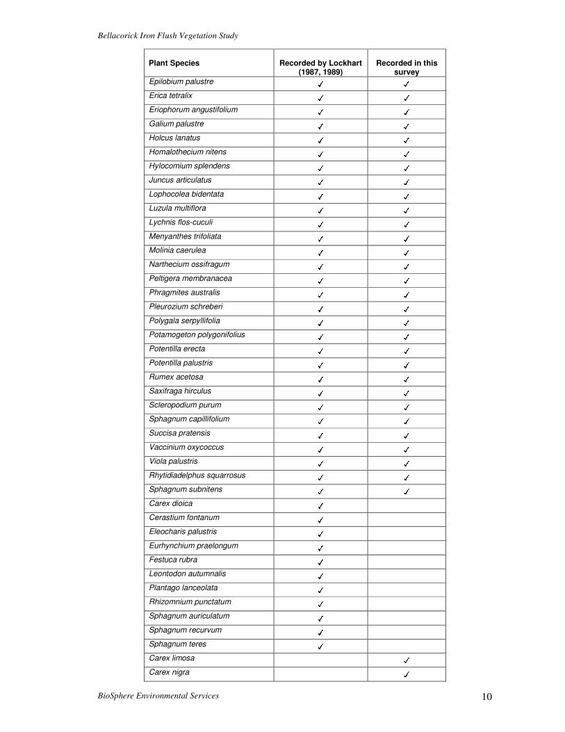
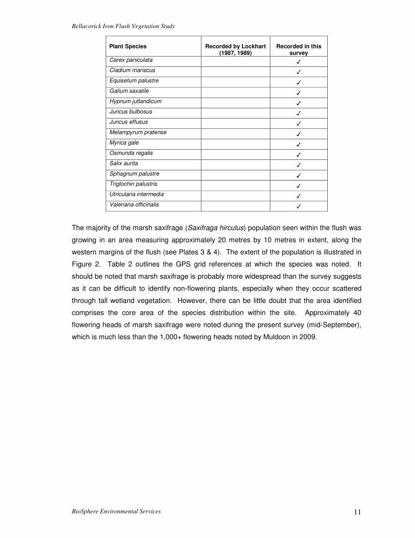
Table 1. List of plant species recorded growing within Bellacorick flush in the present survey
(September 2012) with a comparison to earlier work by Lockhart (1987,1989).
Plant Species
Recorded by Lockhart
(1987, 1989)
Recorded in this
survey Agrostis canina ✓ ✓
Agrostis stolonifera ✓ ✓
Angelica sylvestris ✓ ✓
Anthoxanthum odoratum ✓ ✓
Aulocomium palustris ✓ ✓
Brachythecium rutabulum ✓ ✓
Calliergonella cuspidata ✓ ✓
Calluna vulgaris ✓ ✓
Caltha palustris ✓ ✓
Calypogeia muellerana ✓ ✓
Cardamine pratensis ✓ ✓
Carex diandra ✓ ✓
Carex echinata ✓ ✓
Carex panicea ✓ ✓
Carex rostrata ✓ ✓
Dicranum scoparium ✓ ✓
Bellacorick Iron Flush Vegetation Study
BioSphere Environmental Services 10
Plant Species
Recorded by Lockhart
(1987, 1989)
Recorded in this
survey
Epilobium palustre ✓ ✓
Erica tetralix ✓ ✓
Eriophorum angustifolium ✓ ✓
Galium palustre ✓ ✓
Holcus lanatus ✓ ✓
Homalothecium nitens ✓ ✓
Hylocomium splendens ✓ ✓
Juncus articulatus ✓ ✓
Lophocolea bidentata ✓ ✓
Luzula multiflora ✓ ✓
Lychnis flos-cuculi ✓ ✓
Menyanthes trifoliata ✓ ✓
Molinia caerulea ✓ ✓
Narthecium ossifragum ✓ ✓
Peltigera membranacea ✓ ✓
Phragmites australis ✓ ✓
Pleurozium schreberi ✓ ✓
Polygala serpyllifolia ✓ ✓
Potamogeton polygonifolius ✓ ✓
Potentilla erecta ✓ ✓
Potentilla palustris ✓ ✓
Rumex acetosa ✓ ✓
Saxifraga hirculus ✓ ✓
Scleropodium purum ✓ ✓
Sphagnum capillifolium ✓ ✓
Succisa pratensis ✓ ✓
Vaccinium oxycoccus ✓ ✓
Viola palustris ✓ ✓
Rhytidiadelphus squarrosus ✓ ✓
Sphagnum subnitens ✓ ✓
Carex dioica ✓
Cerastium fontanum ✓
Eleocharis palustris ✓
Eurhynchium praelongum ✓
Festuca rubra ✓
Leontodon autumnalis ✓
Plantago lanceolata ✓
Rhizomnium punctatum ✓
Sphagnum auriculatum ✓
Sphagnum recurvum ✓
Sphagnum teres ✓
Carex limosa ✓
Carex nigra ✓
Bellacorick Iron Flush Vegetation Study
BioSphere Environmental Services 11
Plant Species
Recorded by Lockhart
(1987, 1989)
Recorded in this
survey
Carex paniculata ✓
Cladium mariscus ✓
Equisetum palustre ✓
Galium saxatile ✓
Hypnum jutlandicum ✓
Juncus bulbosus ✓
Juncus effusus ✓
Melampyrum pratense ✓
Myrica gale ✓
Osmunda regalis ✓
Salix aurita ✓
Sphagnum palustre ✓
Triglochin palustris ✓
Utricularia intermedia ✓
Valeriana officinalis ✓
The majority of the marsh saxifrage (Saxifraga hirculus) population seen within the flush was
growing in an area measuring approximately 20 metres by 10 metres in extent, along the
western margins of the flush (see Plates 3 & 4). The extent of the population is illustrated in
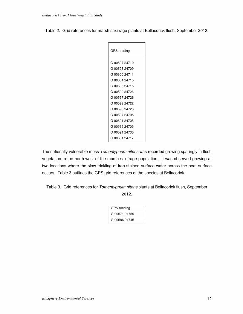
Figure 2. Table 2 outlines the GPS grid references at which the species was noted. It
should be noted that marsh saxifrage is probably more widespread than the survey suggests
as it can be difficult to identify non-flowering plants, especially when they occur scattered
through tall wetland vegetation. However, there can be little doubt that the area identified
comprises the core area of the species distribution within the site. Approximately 40
flowering heads of marsh saxifrage were noted during the present survey (mid-September),
which is much less than the 1,000+ flowering heads noted by Muldoon in 2009.
Bellacorick Iron Flush Vegetation Study
BioSphere Environmental Services 12
Table 2. Grid references for marsh saxifrage plants at Bellacorick flush, September 2012.
GPS reading
G 00597 24710
G 00596 24709
G 00600 24711
G 00604 24715
G 00606 24715
G 00599 24726
G 00597 24726
G 00599 24722
G 00598 24723
G 00607 24705
G 00601 24705
G 00596 24705
G 00591 24730
G 00631 24717
The nationally vulnerable moss Tomentypnum nitens was recorded growing sparingly in flush
vegetation to the north-west of the marsh saxifrage population. It was observed growing at
two locations where the slow trickling of iron-stained surface water across the peat surface
occurs. Table 3 outlines the GPS grid references of the species at Bellacorick.
Table 3. Grid references for Tomentypnum nitens plants at Bellacorick flush, September
2012.
GPS reading
G 00571 24759
G 00586 24745

Bellacorick Iron Flush Vegetation Study
BioSphere Environmental Services 13
Plate 3. A close-up view of marsh saxifrage (Saxifraga hirculus) in flower at Bellacorick flush.
Plate 4. Flowering heads of marsh saxifrage visible in tall, sedge-dominated vegetation.

Bellacorick Iron Flush Vegetation Study
BioSphere Environmental Services 14
Plate 5. Along the eastern margins of the flush the vegetation is dominated by purple moor grass with common reed also conspicuous.
Plate 6. A view of piezometers installed at the northern edge of the flush.

Bellacorick Iron Flush Vegetation Study
BioSphere Environmental Services 15
5. Vegetation associated with couple locations
In order to assess the existing hydrological conditions at the flush a number of groups of
piezometers (subsequently referred to as couples) were installed in mid-September 2012 by
Hydro-Environmental Services. During installation the hydrological team was accompanied
by John Conaghan in order to ensure that sensitive areas of the flush were avoided and that
tracking damage to vegetation was minimized. Prior to this work commencing, the flush area
had been surveyed in order to identify the distribution of marsh saxifrage and the moss
Tomentypnum nitens (as described). Work was then planned and executed in such a way
that couple locations and associated access routes avoided areas in which these important
species grow.
Figure 2. Map showing the vegetation/habitat cover at Bellacorick flush and the location of couples.
Immediately prior to piezometer installation the vegetation composition at the couple
locations was described (see Figure 2 for couple locations). In the following pages the
vegetation composition at these locations is outlined in terms of the dominant plant species
and the main associated plant species growing within a 2 metre radius of the couple location.
In addition, the pH and conductivity readings of associated surface waters recorded by
Hydro-Environmental Services in the mid-September 2012 are also presented in order to

Bellacorick Iron Flush Vegetation Study
BioSphere Environmental Services 16
give an indication of the degree of groundwater influence. See associated report by Hydro-
Environmental Services for more complete hydrochemistry results.
Couple C1 – GPS G 00625 24547
Dominant plant species = Molinia caerulea (90% cover)
Associated plant species = Potentilla palustris, Succisa pratensis, Myrica gale, Potentilla
erecta, Valeriana officinalis, Hylocomium splendens, Carex echinata, Angelica sylvestris,
Juncus effusus.
The dominance of Molinia caerulea at this point suggests the presence of a fluctuating water
table.
No surface water analyses available
Couple C2 – GPS G 00631 24692
Dominant plant species = Carex rostrata and Potentilla palustris (Combined cover 50 to 80%
cover).
Associated plant species = Holcus lanatus, Lychnis flos-cuculi, Agrostis capillaris,
Anthoxanthum odoratum, Angelica sylvestris, Molinia caerulea, Rhytidiadelphus squarrosus,
Aulocomium palustris, Carex diandra, Rumex acetosa, Phragmites australis, Cardamine
pratensis, Scleropodium purum.
This couple is located close to the centre of the flush and is typical of the “core” flush
vegetation generally.
Surface water pH = 6.8, Surface water conductivity = 500 µs/cm
Surface waters at this point would indicate a strong influence of mineral enrichment.
Couple C3 – GPS G 00673 24643
Dominant plant species = Carex nigra (50 to 75% cover).
Associated plant species = Agrostis capillaris, Anthoxanthum odoratum, Rumex acetosa,
Holcus lanatus, Scleropodium purum, Potentilla palustris, Viola palustris, Hylocomium
splendens, Vaccinium oxycoccus. Occasional clumps of Juncus effusus occur within 20
metres.
This couple is located at the south-eastern end of the flush
Surface water pH = 6.3, Surface water conductivity = 300 µs/cm
Surface waters at this point would indicate a moderate influence of mineral enrichment.
Couple C4 – GPS G 00726 24582
Dominant plant species = Molinia caerulea and Sphagnum capillifolium
Associated plant species = Succisa pratensis, Calluna vulgaris, Myrica gale, Erica tetralix,
Narthecium ossifragum, Polygala serpyllifolia, Carex panicea, Trichophorum cespitosum,

Bellacorick Iron Flush Vegetation Study
BioSphere Environmental Services 17
Cladonia portentosa, Sphagnum papillosum, Cladonia uncialis, Hypnum jutlandicum,
Racomitrium lanuginosum, Eriophorum angustifolium and Potentilla erecta. Sphagnum
cover is generally between 40 and 60%.
Surface water pH = 6.3, Surface water conductivity = 85 µs/cm
Surface waters at this point would indicate a low influence of mineral enrichment.
Couple C6 – GPS G 00692 24709
Dominant plant species = Molinia caerulea (70 to 90% cover)
Associated plant species = Anthoxanthum odoratum, Potentilla erecta, Rumex acetosa,
Holcus lanatus, Hypnum jutlandicum, Potentilla palustris, Agrostis capillaris, Hylocomium
splendens, Carex echinata, Angelica sylvestris, Juncus effusus, Phragmites australis, Galium
saxatile.
Couple located at the bottom of a break in slope.
Surface water pH = 7.1, Surface water conductivity = 152 µs/cm
Surface waters at this point would indicate a low influence of mineral enrichment.
Couple C6a – GPS G 00670 24738
Dominant plant species = Molinia caerulea (80 to 90% cover) with conspicuous Phagmites
australis.
Associated plant species = Anthoxanthum odoratum, Succisa pratensis, Potentilla erecta,
Juncus bulbosus, Hypnum jutlandicum, Calluna vulgaris, Agrostis sp. Myrica gale, Potentilla
erecta, Hylocomium splendens, Carex echinata, Angelica sylvestris, Juncus effusus.
Surface water pH = 6.8, Surface water conductivity = 546 µs/cm
Surface waters at this point would indicate a strong influence of mineral enrichment.
Couple C9 – GPS G 00566 24683
Dominant plant species = Molinia caerulea
Associated plant species = Myrica gale, Calluna vulgaris, Succisa pratensis, Carex echinata,
Erica tetralix, Narthecium ossifragum, Menyanthes trifoliata, Eriophorum angustifolium,
Hylocomium splendens and Potentilla erecta.
The vegetation comprises very wet and quaking flushed bog vegetation along the western
margins of the flush area.
Surface water pH = 6.5, Surface water conductivity = 80 µs/cm
Surface waters at this point would indicate a low influence of mineral enrichment.
Couple C10 – GPS G 00444 24658
Dominant plant species = Molinia caerulea and Calluna vulgaris

Bellacorick Iron Flush Vegetation Study
BioSphere Environmental Services 18
Associated plant species = Sphagnum capillifolium, Carex panicea, Schoenus nigricans,
Erica tetralix, Narthecium ossifragum, Trichophorum cespitosum, Cladonia portentosa,
Sphagnum papillosum, Cladonia uncialis, Drosera rotundifolia, and Potentilla erecta.
Sphagnum cover is generally between 40 and 60%.
The vegetation is dominated by typical blanket bog species.
No surface water analyses available
From the initial observations it would appear that the surface waters associated with the
“core” flush vegetation have a higher pH and conductivity than in the surrounding
ombrotrophic blanket bog areas, which are predominantly rain-fed. Ongoing analysis of
water chemistry will further elucidate the linkages between hydrochemistry, water levels and
vegetation.
6. Formoyle Flush
As part of the investigations into the Bellacorick iron flush, NPWS had indicated that
consideration should be given to the flushes to the east of the Oweninny site boundary
(known as Formoyle flush) to ensure that the project would not have any indirect hydrological
impacts on this sensitive area.
Formoyle flush is an extensive area of base-rich fen/flush which is located approximately 4
km north of Eskeragh church in north-west Co. Mayo. The land immediately surrounding the
flush is dominated by intact lowland blanket bog/heath. Further away from the core flush
area there is an extensive area of previously afforested bog to the east and an area of Bord
na Mona industrial cutaway blanket bog to the west.
The flush is generally very wet with many areas dominated by quaking raft of fen vegetation.
A number of narrow flushed channels flow into the main body of the flush from higher ground
to the north and the west. The vegetation at Formoyle flush is generally dominated by black
bog rush (Schoenus nigricans) with common reed (Phragmites australis) also conspicuous.
Other frequent plant species in the vegetation include bog bean (Menyanthes trifoliata), bog
pondweed (Potamogeton polygonifolius), bottle sedge (Carex rostrata) and the moss
Campylium stellatum. In recent decades a number of rare bryophyte species have been
recorded here (Neil Lockhart personal communication).
Whilst it is difficult to accurately assess the extent of the flush habitat at Formoyle there is
little doubt that the flush area at Formoyle is much more extensive than the flush surrounded
by cutaway bog at Bellacorick. The vegetation at Formoyle tends to be dominated by

Bellacorick Iron Flush Vegetation Study
BioSphere Environmental Services 19
Schoenus nigricans, Menyanthes trifoliata and Phragmites australis, whilst the vegetation of
Bellacorick flush tends to be dominated by sedges (Carex sp.) and mosses such as
Hylocomium splendens. Preliminary observations would also suggest that the flush habitat
at Formoyle is much wetter and the peat is much more quaking than at Bellacorick.
The flush area at Formoyle was visited on 28th September 2012 by John Conaghan and
David Broderick. In view of the very fragile nature of the flush habitat and vegetation at
Formoyle the flush habitat was not traversed. The western margins of the flush were walked
and GPS co-ordinates of the westernmost margins of the flush were noted. A number of
water samples were collected for analysis (by Hydro-Environmental Services) from the
western margins of the flush.

Bellacorick Iron Flush Vegetation Study
BioSphere Environmental Services 20
References Conaghan, J. (1995). The ecology of Eriophorum gracile and Eriophorum latifolium in Ireland.
Unpublished PhD. Thesis, National University of Ireland, Galway. Fossitt, J. A. (2000). A guide to habitats in Ireland. The Heritage Council, Ireland. King, A.L.K. (1958a). Meesia tristicha Bruch & Schimp. in Ireland. Irish Naturalists’ Journal.
12: 347. King, A.L.K. (1958b). Camptothecium nitens (Hedw.) Schp. in Ireland. Irish Naturalists’
Journal. 12: 332. King, A.L.K. and Scannell (1960). Notes on the vegetation of a mineral flush in Co. Mayo.
Irish Naturalists’ Journal. 13: 137-14. Lockhart, N.D. (1987). The occurrence of Homalothecium nitens (Hedw.) Robins. in Ireland.
Journal of Bryology 14: 511-517. Lockhart, N.D. (1989). Three new localities for Saxifraga hirculus L. in Ireland. Irish
Naturalists’ Journal. 23: 65-69. Lockhart, N.D. (1991). Phytosociological and ecological studies of lowland blanket bog
flushes in west Galway and north Mayo. Unpublished PhD. Thesis, National University of Ireland, Galway.
Lockhart, N.D., Hodgetts, N. and Holyoak, D. (2012). Rare and threatened bryophytes of
Ireland. National Museums Northern Ireland, Holywood, Co. Down. Muldoon, C.S (2011). Conservation biology of Saxifraga hirculus L. in Ireland. Unpublished
PhD. Thesis, University of Dublin, Trinity College. Scannell, M.J.P. (1958). Saxifraga hirculus in Co. Mayo. Irish Naturalists’ Journal. 12, 248. Smith, A.J.E. (2004). The Moss Flora of Britain and Ireland (2nd edition). University Press,
Cambridge. Stace, C. (2010). New Flora of the British Isles (3rd edition). University Press, Cambridge.

Couple Lithology Von Post
C1
0 - 0.12 Wet fibrous peat with vegetation roots H2/H3
0.12-0.9 Black soft PEAT with some visible vegetation fibres H6/H7
0.9-1.7 Black and orange (interbedded colouring) soft PEAT H6/H7
1.7-3.26
dark brown/black soft PEAT with some visible vegetation fibres (more
fen type peat) H4/H5
3.26-3.31 Soft yellow slightly sandly CLAY (precipitate)
3.31-3.51 Coarse grey SAND
3.51-4.24
Soft to Firm, grey, damp, slightly silty fine SAND with very occassional
gravel clasts.
C2
0 - 0.15 Wet fibrous peat with vegetation roots H2/H3
0.15-2.0 Soft, brown PEAT, with some visible vegetation fibres H4/H5
2.0-2.86 Soft, wet, black PEAT H5/H6
2.86-2.90 Loose, coarse grey SAND
2.90-3.3 Soft, grey/black, damp SILT/CALY with occassional pebbles
3.3-4.0
Medium dense to firm, grey, damp fine SAND, with very occassional
gravel clasts at depth (dead sand, not very permeable).
C3
0 - 0.2 Wet fibrous peat with vegetation roots H2/H3
0.2-2.74
Soft, brown, wet PEAT, with some visible vegetation fibres reducing
with depth H5/H7
C4
0 - 0.1 Wet fibrous peat with vegetation roots H2/H3
0.1-2.45 Soft, light brown, wet fibrous PEAT H3/H4
decreasing fibre content with depth H5/H7
red wood remains @ 2.1mbgl
2.88-2.45 black soft PEAT H6/H7
2.88-2.98 grey wet fine silty SAND (dilatent)
C6
0 - 0.2 Wet fibrous peat with vegetation roots H2/H3
0.2-0.9 Soft, brown, dryish/damp PEAT, with some visible vegetation fibres H6/H7
0.9-1.1
Loose, brown, coarse SAND with occ. Peat roots and very occc.
Shell fragments and rounded pebbles
1.1-2.35
Medium dense, grey damp SAND, with occ. Gravel clasts (likley low
permeability, dead sand)
2.35-2.55 Dense, grey sandy GRAVEL
2.55-3.45 Soft grey slightly clayey, sandy SILT with occ. angular Gravel clasts

C6A
0 - 0.2 Wet fibrous peat with vegetation roots H2/H3
0.2-0.91
Soft, brown, dryish/damp PEAT, with some visible vegetation fibres
throughout H5/H6
0.91-2.5
grey fine silty SAND (dead sand), with occ. Gravel clasts, with very
solft wet layer between 2.5 - 3.6mbgl
2.5-3.6
firm to stiff grey/redish, fine silty SAND with very occ. Clay and gravel
clasts
3.6-4.0 Grey coarse SAND with occ. Gravel clasts
4.0-4.24 firm blue/grey dense silty SAND with occ. Fine medium gravel clasts
C7
0 - 0.20 Light brown, poorly humified fibrous PEAT H2/H3
0.2-1.0
Light brown, poorly humified PEAT with visible fine white vegetation
fibres H4/H5
C8
0 - 0.20 Light brown, poorly humified fibrous PEAT H2/H3
0.2-1.41
Light brown, damp, poorly humified PEAT with visible fine white
vegetation fibres H4/H5
>1.41 gravelly/sandy feel to mineral soil below peat
C9
0-1 no recovery
1.0-2.0 very soft wet fibrous PEAT H4/H5
2.0-3.0 very wet soft dark brown PEAT with occ. phragmities remains H5/H6
3.0-4.10 dark brown to black very wet, very soft PEAT H6
>4.1 SAND at base @4.10mbg;
C10
0-0.2 very soft wet fibrous PEAT
0.2-2.95 very wet soft dark brown PEAT with occ. phragmities remains
>2.95 SAND at base @2.95mbg;

90.0
90.5
91.0
91.5
92.0
92.5
93.0
93.5
08/09/2012 28/09/2012 18/10/2012 07/11/2012 27/11/2012
m O
D
Date
Bellacorick - Couple C1
C1-P1
C1-P2
C1-PH1
95.2
95.4
95.6
95.8
m O
D
Bellacorick - Couple C2
C2-P1
94.4
94.6
94.8
95.0
08/09/2012 28/09/2012 18/10/2012 07/11/2012 27/11/2012
m O
D
Date
C2-P1
C2-P2
C2-PH1
93.5
94.0
94.5
95.0
95.5
96.0
96.5
97.0
08/09/2012 28/09/2012 18/10/2012 07/11/2012 27/11/2012
m O
D
Date
Bellacorick - Couple C3
C3-P1
C3-P2
C3-PH1

94.0
94.5
95.0
95.5
96.0
96.5
97.0
97.5
08/09/2012 28/09/2012 18/10/2012 07/11/2012 27/11/2012
m O
D
Date
Bellacorick - Couple C4
C4-P1
C4-PH1
96.096.597.0
Bellacorick - Couple C6
93.093.594.094.595.095.596.0
08/09/2012 28/09/2012 18/10/2012 07/11/2012 27/11/2012
m O
D
Date
C6-P1
C6-P2
C6-PH1
92.50
93.00
93.50
94.00
94.50
95.00
95.50
96.00
08/09/2012 28/09/2012 18/10/2012 07/11/2012 27/11/2012
m O
D
Date
Bellacorick - Couple C6A
C6A-P1
C6A-P2
C6A-PH1

94.70
94.75
94.80
94.85
94.90
94.95
29/08/2012 23/09/2012 18/10/2012 12/11/2012
m O
D
Date
Bellacorick - Couple C9
C9-P1
C9-PH1
93.5
94.0
94.5
Bellacorick - Couple C10
91.5
92.0
92.5
93.0
93.5
08/09/2012 28/09/2012 18/10/2012 07/11/2012 27/11/2012
m O
D
Date
C10-PH1
C10-P1

Bellacorick Iron Flush P1196
90.0
90.5
91.0
91.5
92.0
92.5
93.0
93.5
29/08/2012 18/10/2012 07/12/2012 26/01/2013 17/03/2013
m O
D
Date
Bellacorick - Couple C1
C1-P1
C1-P2
C1-PH1
95.2
95.4
95.6
95.8
m O
D
Bellacorick - Couple C2
Appendix II
94.4
94.6
94.8
95.0
95.2
29/08/2012 18/10/2012 07/12/2012 26/01/2013 17/03/2013
m O
D
Date
C2-P1
C2-P2
C2-PH1
93.5
94.0
94.5
95.0
95.5
96.0
96.5
97.0
29/08/2012 18/10/2012 07/12/2012 26/01/2013 17/03/2013
m O
D
Date
Bellacorick - Couple C3
C3-P1
C3-P2
C3-PH1
Appendix II

Bellacorick Iron Flush P1196
94.0
94.5
95.0
95.5
96.0
96.5
97.0
97.5
29/08/2012 18/10/2012 07/12/2012 26/01/2013 17/03/2013
m O
D
Date
Bellacorick - Couple C4
C4-P1
C4-PH1
97.0
Bellacorick - Couple C6
Appendix II
93.093.594.094.595.095.596.096.597.0
29/08/2012 18/10/2012 07/12/2012 26/01/2013 17/03/2013
m O
D
Date
C6-P1
C6-P2
C6-PH1
92.50
93.00
93.50
94.00
94.50
95.00
95.50
96.00
29/08/2012 18/10/2012 07/12/2012 26/01/2013 17/03/2013
m O
D
Date
Bellacorick - Couple C6A
C6A-P1
C6A-P2
C6A-PH1
Appendix II

Bellacorick Iron Flush P1196
94.70
94.75
94.80
94.85
94.90
94.95
95.00
29/08/2012 18/10/2012 07/12/2012 26/01/2013 17/03/2013
m O
D
Date
Bellacorick - Couple C9
C9-P1
C9-PH1
93.5
94.0
94.5
Bellacorick - Couple C10
Appendix II
91.5
92.0
92.5
93.0
93.5
29/08/2012 18/10/2012 07/12/2012 26/01/2013 17/03/2013
m O
D
Date
C10-PH1
C10-P1
Appendix II
Table 1: Recharge coefficients for different hydrogeological settings.
Recharge coefficient (rc) Vulnerability category Hydrogeological setting
Min (%) Inner Range Max (%)* 1.i Areas where rock is at ground surface 60 80-90 100 1.ii Sand/gravel overlain by ‘well drained’ soil 60 80-90 100
Sand/gravel overlain by ‘poorly drained’ (gley) soil 1.iii Till overlain by ‘well drained’ soil 45 50-70 80 1.iv Till overlain by ‘poorly drained’ (gley) soil 15 25-40 50 1.v Sand/ gravel aquifer where the water table is ≤ 3 m below surface 70 80-90 100
Extreme
1.vi Peat 15 25-40 502.i Sand/gravel aquifer, overlain by ‘well drained’ soil 60 80-90 100 2.ii High permeability subsoil (sand/gravel) overlain by ‘well drained’ soil 60 80-90 100 2.iii High permeability subsoil (sand/gravel) overlain by ‘poorly drained’ soil 2.iv Moderate permeability subsoil overlain by ‘well drained’ soil 35 50-70 80 2.v Moderate permeability subsoil overlain by ‘poorly drained’ (gley) soil 15 25-40 50 2.vi Low permeability subsoil 10 23-30 40
High
2.vii Peat 0 5-15 203.i Moderate permeability subsoil and overlain by ‘well drained’soil 25 30-40 60 3.ii Moderate permeability subsoil and overlain by ‘poorly drained’ (gley) soil 10 20-40 50 3.iii Low permeability subsoil 5 10-20 30
Moderate
3. iv Basin peat 0 3-5 10 4.i Low permeability subsoil 2 5-15 20Low 4.ii Basin peat 0 3-5 105.i High Permeability Subsoils (Sand & Gravels) 60 85 100 5.ii Moderate Permeability Subsoil overlain by well drained soils 25 50 80 5.iii Moderate Permeability Subsoils overlain by poorly drained soils 10 30 50 5.iv Low Permeability Subsoil 2 20 40
High to Low
5.v Peat 0 5 20Acknowledgement: many of the recharge coefficients in this table are based largely on a paper submitted by Fitzsimons and Misstear (in press).
page 6 of 23