overview of southwestern pennsylvania commission’s (spc ... · environmental addendum for...
TRANSCRIPT

Overview of Southwestern Pennsylvania
Commission’s (SPC) 2040 Long Range
Transportation Plan (LRTP)
Presented to PA Agency Coordination Meeting
May 25th 2011
Chuck DiPietro

Southwestern Pennsylvania Region
• 10 Counties
• >7,000 Square miles
• 2.66 Million citizens
• 549 Municipalities
• 132 School Districts
• 3 PennDOT Districts
• > 5,300 State-owned Bridges
• 10 Fixed Route Transit Agencies
• 3 TMAs

SPC 2040 Long Range Plan
Overall Plan Policy Statements
Regional Places (3)
• Revitalization and redevelopment of the region’s
existing communities is a priority.
• Investment in infrastructure improvements will be
coordinated and targeted at the corridor level to
optimize the impact of the investment.
• The region will focus on the identification and
development of industrial sites with special
attention given to well situated brownfield locations.

Overall Plan Policy Statements
Regional Connections (6)
• Maintenance of the existing transportation system will be a regional priority.
• Transportation and development choices will reflect a priority on safe and secure multimodal and intermodal networks for both people and goods.
• The region’s transportation system will be actively managed and operated to allow the system to function at its full potential.
• The region’s transit system will connect people with resources throughout the entire region.
• The entire region will have access to broadband communications infrastructure.
• The region’s infrastructure system will be designed to protect and enhance public health and the environment.

Regional Activities (7)
• The region will place a priority on business development with a focus on existing business retention and expansion.
• The region will support initiatives designed to improve both the quality and quantity of the region’s workforce to meet emerging industry demands.
• The region will support identified strategic industry clusters.
• The region will place a priority on programs and services to attract and retain a diverse population with a particular focus on young adults and immigrants.
• The region will proactively support the emerging role of colleges and universities in economic development.
• The region will preserve, promote and develop the tourism and hospitality industries by capitalizing on historic, cultural, recreational and ecological assets.
• The region will preserve and develop its agricultural industry.
Overall Plan Policy Statements

Various Plan Components
• Transportation Needs Assessment & Investment Categories
• Population, Household, and Employment Forecasts
• Regional Operations Plan
• Public Participation Plan
• Environmental Addendum (NEW Element)
• Human Services Coordinated Transportation Plan
• Marcellus Shale Component
• Air Quality Conformity Determination for Plan Update
• Report on Environmental Justice from 2040 Plan Update
• Illustrative Transportation Project List & Proposed Study Element
• Transit, Inter-modal, Freight, and Ridesharing Elements
• Update Comprehensive Development Strategy (CEDS) for EDA - Program of Projects/Needs Assessment
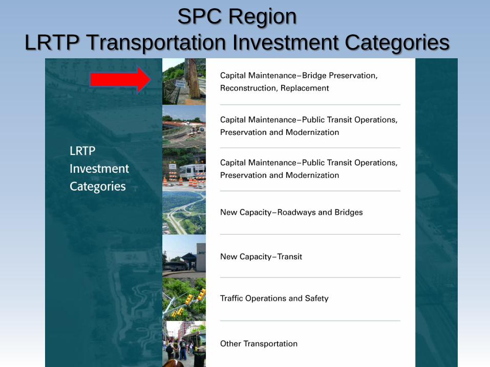
SPC Region
LRTP Transportation Investment Categories

Transportation Financial Plan
Investments By Categories
48%
25%
3%
21%
3%
HIGHWAY INVESTMENT CATEGORIES
Capital Maintenance Bridge
Capital Maintenance Highway
New Capacity Roadway
Operations and Safety
Other

Transportation Needs:
Structurally Deficient Bridge Crisis - SPC Region
• 1,482 State-Owned Bridges in the SPC Region are Structurally Deficient (SD)
• Rate of Deterioration: 99 State bridges in the Region became SD in 2010
• Below Critical Threshold At Cautionary Threshold

Challenges/Requirements
• Overall Difficult Climate for the plan Update– Transportation Funding Crisis– Uncertain Federal and State Funding Levels– Changing priorities at the Federal Level (new Congress)– Changing priorities at the State Level New State
Administration
• The 2040 plan meets Federal Requirements– 20 year planning horizon– Fiscally Constrained – Public Involvement– Air Quality Conformity Determination– Environmental Justice Benefits and Burdens– Multi-modal aspects

• Some benefits of LPN & “earlier
identification of issues”:
- Predictability
- More Appropriate Solutions
- Context Sensitivity
- Clearer Scope
- Better Cost Estimate/Budget
- More Accurate Schedule
Plan ImplementationLinking Planning and NEPA Initiative

Transportation Planning and Environmental Linkage
Aspects of the SPC 2040 LRTP
Presented to PA Agency Coordination Meeting
May 25th 2011
Ryan Gordon, Planner SPC
• PHOTO

Planning and Environmental LinkageLinking Planning and NEPA
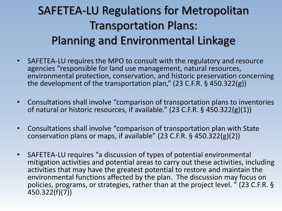
SAFETEA-LU Regulations for Metropolitan Transportation Plans:
Planning and Environmental Linkage
• SAFETEA-LU requires the MPO to consult with the regulatory and resource agencies “responsible for land use management, natural resources, environmental protection, conservation, and historic preservation concerning the development of the transportation plan,” (23 C.F.R. § 450.322(g))
• Consultations shall involve “comparison of transportation plans to inventories of natural or historic resources, if available.” (23 C.F.R. § 450.322(g)(1))
• Consultations shall involve “comparison of transportation plan with State conservation plans or maps, if available” (23 C.F.R. § 450.322(g)(2))
• SAFETEA-LU requires “a discussion of types of potential environmental mitigation activities and potential areas to carry out these activities, including activities that may have the greatest potential to restore and maintain the environmental functions affected by the plan. The discussion may focus on policies, programs, or strategies, rather than at the project level. ” (23 C.F.R. §450.322(f)(7))

SPC Approach
• Expand our spatial data holdings to include more environmental resource data
• Conduct Earlier Coordination Efforts with PennDOT District Environmental Units and Resource Agencies
• Develop spatial analysis methods to screen projects based on the environmental resource data sets
• Begin to utilize some Integrated Planning techniques
• Develop Environmental Addendum for the 2040 LRTP– 1 Introduction– 2 Regulatory Context– 3 Agency Consultation– 4 Resource Inventory– 5 Existing State Conservation Plans and Maps– 6 Environmental Screening– 7 Potential Environmental Mitigation– 8 Summary and Next Steps
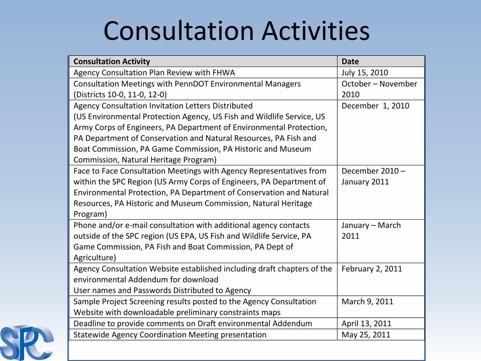
Consultation ActivitiesConsultation Activity Date
Agency Consultation Plan Review with FHWA July 15, 2010
Consultation Meetings with PennDOT Environmental Managers (Districts 10-0, 11-0, 12-0)
October – November 2010
Agency Consultation Invitation Letters Distributed (US Environmental Protection Agency, US Fish and Wildlife Service, US Army Corps of Engineers, PA Department of Environmental Protection, PA Department of Conservation and Natural Resources, PA Fish and Boat Commission, PA Game Commission, PA Historic and Museum Commission, Natural Heritage Program)
December 1, 2010
Face to Face Consultation Meetings with Agency Representatives from within the SPC Region (US Army Corps of Engineers, PA Department of Environmental Protection, PA Department of Conservation and Natural Resources, PA Historic and Museum Commission, Natural Heritage Program)
December 2010 – January 2011
Phone and/or e-mail consultation with additional agency contacts outside of the SPC region (US EPA, US Fish and Wildlife Service, PA Game Commission, PA Fish and Boat Commission, PA Dept of Agriculture)
January – March 2011
Agency Consultation Website established including draft chapters of the environmental Addendum for download User names and Passwords Distributed to Agency
February 2, 2011
Sample Project Screening results posted to the Agency Consultation Website with downloadable preliminary constraints maps
March 9, 2011
Deadline to provide comments on Draft environmental Addendum April 13, 2011
Statewide Agency Coordination Meeting presentation May 25, 2011
((Consultation Website))
Review what is on the website for download
*RETURN TO PP

Linking Planning and NEPAResource Inventory Mapping
• Sub areas for Inventory maps
• Different Resource Inventory Maps in each Sub area– Streams
– Wetlands Indicators
– T&E Species Indicators
– Farmlands Resources
– Protected Lands
– Historic Resources
– Industrial Areas & Waste Site Indicators


Existing “State Conservation Plans and Maps”• Various state financed (DCNR) River and Watershed Conservation Plans
http://www.dcnr.state.pa.us/brc/rivers/riversconservation/planningprojects/
• PA DEP Statewide Water Resources Plan, 2010 http://www.pawaterplan.dep.state.pa.us/StateWaterPlan/docroot/Default.aspx
• State financed (DCNR) county greenway plans http://www.pagreenways.org/greenwaysnetworks-planning.htm
• PA Game Commission and PA Fish and Boat Commission, Pennsylvania Comprehensive Wildlife Conservation Strategy, 2005 http://www.wildlifeactionplans.org/pdfs/action_plans/pa_action_plan.pdf
• Associated Conservation Opportunity Areas, 2011 http://www.dcnr.state.pa.us/wrcp/wildnotes/winter11/index.html
• Pennsylvania Historic and Museum Commission, Pennsylvania Preservation Plan 2006-2011. http://www.portal.state.pa.us/portal/server.pt/community/historic_preservation/3741/preservation_plan/418112
• Western PA Conservancy, PA Aquatic Community Classification, 2007 http://www.naturalheritage.state.pa.us/aquaticsIntro.aspx
• Western PA Conservancy, Conservation Priorities, 2010 http://conservingpa.org/253/preserving-priority-landscapes-2
• DCNR Bureau of Forestry, State Forest Resource Management Plan, 2007 http://www.dcnr.state.pa.us/forestry/sfrmp/sfrmp_update_2007.pdf
• DCNR Bureau of Forestry, Statewide Forest Resource Assessment, 2010 http://www.dcnr.state.pa.us/forestry/farmbill/assessment.aspx
• Natural Heritage Inventories, County Inventories http://www.naturalheritage.state.pa.us/CNAI_Download.aspx
• DCNR Conservation Landscape Initiative Areas http://www.dcnr.state.pa.us/cli/index.aspx
• DCNR Heritage Areas http://www.dcnr.state.pa.us/brc/heritageparks/heritageregions_web.aspx
• PA Fishing and Boating Access Strategy plan http://www.fishandboat.com/accessplan.htm
• County Comprehensive Plans that have environmental and cultural resource aspects (example Allegheny Places green space and historic preservation aspects) http://www.alleghenyplaces.com/comprehensive_plan/comprehensive_plan.aspx


Project Screenings
• Conducted to compare environmental inventory to planned transportation projects
• Over 60 environmental inventory data layers (more detailed than the overview inventory)
• Project types with the greatest potential to have environmental impacts
• Realistic new TIP project candidates for early phases in next two TIP cycles (2013 -2018). Projects from the plan that are also listed on PennDOT 12-year plan or on District candidate lists
• Project screenings result in summary checklist and preliminary constraint maps for each project


• Review the Matrix of all the Projects
• In-depth checklists and preliminary constraint maps on a few example projects
– 74200 –
* RETURN TO PP
((Consultation Website))Project Screening Examples

Types of Potential Mitigation Activities and Potential Areas to Carry Out Activities
• Photos of mitigation
• Approach to focus on potential strategies and options for mitigation activities for the key resource types in the SPC region
• Focused on a few Resources:– Wetlands
– Streams
– Threatened and Endangered Species
– Cultural Resources
– Other Section 4(f) resources
– Farmlands
• Created table for each of the resources listed mitigation options associated with that resource including potential locations
• Included discussion of Advanced Compensatory mitigation where applicable

Example of the Potential Mitigation Activities Tables
• Historic Resources (other resources follow same format)
• “Types of Potential Mitigation Activities” listed for both individual project and Advanced compensatory mitigation
• Information provided related to “areas to carryout these activities”

Potential Next Steps Proposed Activity Description Time Frame PennDOT Project Development Process Linking Planning and NEPA project screening forms
Participating in PennDOT’s new project development process through the coordination of a screening form process for analyzing new candidate projects for the TIP. Providing preliminary constraint maps when applicable. Participate in project planning screening field views if applicable.
Short Term
District Project Development Work Groups
Establishment of work groups within each District to support the screening form process, including project purpose and need development and environmental screening. The committee strengthens SPC’s capabilities to coordinate consensus on the status of new project candidates for the TIP.
Short Term
SPC-PennDOT District Environmental Unit work group
Coordination group between SPC planners and the PennDOT District Environmental Units. Conduct project environmental screenings and provide summary report and preliminary constraint maps.
In Place Ongoing As Needed
Greater coordination and data sharing with agencies
Utilize the contacts made during the development of this document to expand information sharing and data sharing. Utilize PennDOT Central Office and ACM.
Short Term
Continue to Develop/Update GIS datasets (especially region specific data)
Development of additional spatial datasets and improvement of existing datasets and models for evaluating environmental aspects of planned transportation projects.
On going
Continued Awareness of Resource Management and Conservation Plans
Monitoring the development of any new or updated resource management plans (example PHMC’s 2012 Statewide Historic Preservation Plan)
Mid-Term
Build Collaborative Partnerships
- PHMC/SPC - Others?
Partnerships with agencies for specific studies. Example is a proposed partnership between PHMC (Historic Preservation Office) and SPC to identify additional significant cultural resources within the region and potential mitigation areas.
Mid-Term
Regional Environmental Work Group
Consider the establishment of an environmental resource work group to assist in future activities and LRTP development. The committee could coordinate planning and environment linkages with emphasis on consultation and cooperation on identifying resources, strategizing potential mitigation measures, and analyzing potential impacts.
Long-Term Conceptual
Work to Develop Regional Ecosystem Framework
Develop an “overlay” of maps of agencies’ individual conservation or resource management plans, accompanied by descriptions of conservation goals in the region. Agency agreement on identified sensitive areas and conservation goals.
Long-Term Conceptual
Work to Develop Mitigation Planning Tools
Develop tools to conduct analysis of potential mitigation areas in the Long-Range Transportation Plan.
Long-Term Conceptual

Feedback/Discussion/Questions
Ryan GordonPlanner, SPC
[email protected]://www.spcregion.org/lrpenv/
Chuck DiPietroTransportation Planning Director, SPC
[email protected]://www.spcregion.org