otay ranch resort village archaeological ......otay ranch resort village archaeological/historical...
TRANSCRIPT

OTAY RANCH RESORT VILLAGE ARCHAEOLOGICAL/HISTORICAL STUDY
COUNTY OF SAN DIEGO
USGS Jamul Mountains Quadrangle; 1,869 Acres
GPA 04-03/REZ 04-009/SP 04-02/TM 5361/Log No. 04-19-005
Applicants: JPB Development, LLC
1392 East Palomar Street, Suite 202 Chula Vista, California 91913
And:
Baldwin & Sons, LLC 610 West Ash Street, Suite 1500
San Diego, California 92101
Lead Agency: County of San Diego
Planning and Development Services Contact: Dennis Campbell
5510 Overland Drive, 3rd Floor, Suite 310 San Diego, California 92123
(858) 505-6380
Prepared by: Brian F. Smith, Principal Investigator,
Johnna L. Buysse, Project Archaeologist, Larry Pierson, Senior Historian,
Michael Tuma, Project Archaeologist, and Kyle Guerrero, Project Archaeologist
Signature: _____________________ Brian F. Smith and Associates, Inc.
14010 Poway Road, Suite A Poway, California 92064
(858) 484-0915
November 22, 2010; Revised August 26, 2014

An Archaeological/Historical Study for the Otay Ranch Village 13 Project –––––––––––––––––––––––––––––––––––––––––––––––––––––––––––––––––––––––––––––––––––––––––––––––––––––––––––––––––––––
National Archaeological Database Information
Author(s): Brian F. Smith, Principal Investigator, Johnna L. Buysse, Project
Archaeologist, Larry Pierson, Senior Historian, Michael Tuma, Project Archaeologist, and Kyle Guerrero, Project Archaeologist
Consulting Firm: Brian F. Smith and Associates, Inc. 14010 Poway Road, Suite A Poway, California 92064 (858) 484-0915 Report Date: November 22, 2010; Revised August 26, 2014 Report Title: Otay Ranch Resort Village Archaeological/Historical Study,
County of San Diego Client/ Project Proponent: JPB Development, LLC 1392 East Palomar Street, Suite 202
Chula Vista, California 91913
Baldwin & Sons, LLC 610 West Ash Street, Suite 1500 San Diego, California 92101
Lead Agency: County of San Diego
Planning and Development Services 5510 Overland Avenue, 3rd Floor, Suite 310 San Diego, California 92123
USGS Quadrangle: Jamul Mountains, California (7.5 minute) Acreage: 1,869 acres Key Words: SDI-I-222, SDI-11,388, SDI-11,389, SDI-11,391A, SDI-11,391B,
SDI-11,391C, SDI-11,391/H, SDI-11,404, SDI-11,405, SDI-11,406, SDI-11,407, SDI-11,408, SDI-11,409, SDI-11,414, SDI-12,336, SDI-12,338, SDI-12,339A, SDI-12,339B, SDI-12,340, SDI-12,341, SDI-12,342, SDI-12,343, SDI-12,353, SDI-12,355, SDI-12,356, SDI-12,357, SDI-12,358, SDI-12,359, SDI-12,360, SDI-12,361, SDI-12,362/H, SDI-12,363, SDI-12,364, SDI-12,365, SDI-12,366, SDI-12,367, SDI-12,368, SDI-12,369, SDI-12,370, SDI-12,371, SDI-12,372, SDI-16,303, SDI-16,304, SDI-16,305, SDI-16,306, SDI-16,307, SDI-16,308, SDI-16,309, SDI-16,310, SDI-16,311, SDI-16,312, SDI-16,313, SDI-16,314, SDI-16,315, SDI-16,316, SDI-16,317, SDI-16,318, SDI-16,319,

An Archaeological/Historical Study for the Otay Ranch Village 13 Project –––––––––––––––––––––––––––––––––––––––––––––––––––––––––––––––––––––––––––––––––––––––––––––––––––––––––––––––––––––
SDI-16,320, SDI-16,321, SDI-16,322, SDI-16,323, SDI-16,324, SDI-16,325, SDI-16,326, SDI-16,327, SDI-16,328, SDI-16,329, SDI-16,330, SDI-16,331, SDI-16,332, SDI-16,333, SDI-16,334, SDI-16,335, SDI-16,336, SDI-16,390, SDI-16,391, SDI-11,390/H, SDI-12,354/H; quarry sites; temporary campsites; lithic tools; Elko projectile point; Archaic; ceramics; Late Prehistoric; significant sites; historic sites; mitigation, data recovery, and preservation.

An Archaeological/Historical Study for the Otay Ranch Village 13 Project –––––––––––––––––––––––––––––––––––––––––––––––––––––––––––––––––––––––––––––––––––––––––––––––––––––––––––––––––––––
Table of Contents Page 1.0 MANAGEMENT SUMMARY / ABSTRACT .......................................................... 1.0–1 2.0 INTRODUCTION ...................................................................................................... 2.0–1 2.1 Project Description ..................................................................................................... 2.0–1 2.2 Scope of Current Study .............................................................................................. 2.0–6 2.3 Applicable Regulations .............................................................................................. 2.0–7
2.3.1 California Environmental Quality Act (CEQA) ............................................... 2.0–7 2.3.2 San Diego County Local Register of Historical Resources (Local Register) ........................................................................................................... 2.0–10 2.3.3 Otay Ranch Phase 2 Resource Management Plan (RMP) ................................ 2.0–11 2.4 Guidelines for Determining Significance .......................................................... 2.0–11 3.0 PROJECT SETTING AND BACKGROUND RESEARCH ..................................... 3.0–1 3.1 Environmental Setting ................................................................................................ 3.0–1 3.1.1 Physical Environment ....................................................................................... 3.0–1 3.1.2 Biological Environment .................................................................................... 3.0–2 3.1.3 Current Land Use ............................................................................................. 3.0–2 3.2 Cultural Setting ........................................................................................................... 3.0–2 3.2.1 Paleoenvironment ............................................................................................. 3.0–3 3.2.2 Prehistory .......................................................................................................... 3.0–3 3.2.3 Native American Perspective ........................................................................... 3.0–5 3.2.4 History .............................................................................................................. 3.0–5 3.3 Rancho History ........................................................................................................... 3.0–8 3.4 Records Search and Previous Studies ......................................................................... 3.0–13 4.0 RESEARCH DESIGN ................................................................................................ 4.0–1 4.1 Research Topics .......................................................................................................... 4.0–3 4.1.1 The Role of Quarry Sites Within the Project Area ........................................... 4.0–3 4.1.2 The Role of Temporary Camps Within the Project Area ................................. 4.0–5 5.0 METHODOLOGY ..................................................................................................... 5.0–1 5.1 Field Methodology ..................................................................................................... 5.0–1 5.1.1 Field Survey ...................................................................................................... 5.0–1 5.1.2 Off-Site Improvement Survey .......................................................................... 5.0–2 5.1.3 Surface Collection ............................................................................................ 5.0–2 5.1.4 Shovel Test Excavations ................................................................................... 5.0–4

An Archaeological/Historical Study for the Otay Ranch Village 13 Project –––––––––––––––––––––––––––––––––––––––––––––––––––––––––––––––––––––––––––––––––––––––––––––––––––––––––––––––––––––
Table of Contents (continued)
Page 5.1.5 Test Unit Excavations ....................................................................................... 5.0–4 5.2 Laboratory Methods ................................................................................................... 5.0–5 5.2.1 Artifact Analysis ............................................................................................... 5.0–5 5.2.2 Ecofact Analyses .............................................................................................. 5.0–5 5.3 Records Searches ........................................................................................................ 5.0–6 5.4 Curation ...................................................................................................................... 5.0–6 5.5 Native American Consultation ................................................................................... 5.0–6 5.6 Native American Sacred Lands File Search ............................................................... 5.0–7 6.0 REPORT OF FINDINGS (PREHISTORIC SITES) .................................................. 6.0–1 6.1 Site SDI-I-222 ............................................................................................................ 6.1–1 6.1.1 Site Description ................................................................................................ 6.1–1 6.1.2 Previous Investigations ..................................................................................... 6.1–1 6.1.3 Description of Field Investigations .................................................................. 6.1–1 6.1.4 Discussion ......................................................................................................... 6.1–2 6.1.5 Summary ........................................................................................................... 6.1–3 6.2 Site SDI-11,388 .......................................................................................................... 6.2–1 6.2.1 Site Description ................................................................................................ 6.2–1 6.2.2 Previous Investigations ..................................................................................... 6.2–1 6.2.3 Description of Field Investigations .................................................................. 6.2–1 6.2.4 Laboratory Analysis ......................................................................................... 6.2–3 6.2.5 Discussion ......................................................................................................... 6.2–4 6.2.6 Summary ........................................................................................................... 6.2–4 6.3 Site SDI-11,389 .......................................................................................................... 6.3–1 6.3.1 Site Description ................................................................................................ 6.3–1 6.3.2 Previous Investigations ..................................................................................... 6.3–1 6.3.3 Description of Field Investigations .................................................................. 6.3–1 6.3.4 Laboratory Analysis ......................................................................................... 6.3–2 6.3.5 Discussion ......................................................................................................... 6.3–2 6.3.6 Summary ........................................................................................................... 6.3–3 6.4 Site SDI-11,391A ....................................................................................................... 6.4–1 6.4.1 Site Description ................................................................................................ 6.4–1 6.4.2 Previous Investigations ..................................................................................... 6.4–1 6.4.3 Description of Field Investigations .................................................................. 6.4–1 6.4.4 Discussion ......................................................................................................... 6.4–3

An Archaeological/Historical Study for the Otay Ranch Village 13 Project –––––––––––––––––––––––––––––––––––––––––––––––––––––––––––––––––––––––––––––––––––––––––––––––––––––––––––––––––––––
Table of Contents (continued)
Page 6.4.5 Summary ........................................................................................................... 6.4–4 6.5 Site SDI-11,391B ....................................................................................................... 6.5–1 6.5.1 Site Description ................................................................................................ 6.5–1 6.5.2 Previous Investigations ..................................................................................... 6.5–1 6.5.3 Description of Field Investigations .................................................................. 6.5–1 6.5.4 Laboratory Analysis ......................................................................................... 6.5–2 6.5.5 Discussion ......................................................................................................... 6.5–3 6.5.6 Summary ........................................................................................................... 6.5–4 6.6 Site SDI-11,391C ....................................................................................................... 6.6–1 6.6.1 Site Description ................................................................................................ 6.6–1 6.6.2 Previous Investigations ..................................................................................... 6.6–1 6.6.3 Description of Field Investigations .................................................................. 6.6–1 6.6.4 Laboratory Analysis ......................................................................................... 6.6–3 6.6.5 Discussion ......................................................................................................... 6.6–4 6.6.6 Summary ........................................................................................................... 6.6–5 6.7 Site SDI-11,404 .......................................................................................................... 6.7–1 6.7.1 Site Description ................................................................................................ 6.7–1 6.7.2 Previous Investigations ..................................................................................... 6.7–1 6.7.3 Description of Field Investigations .................................................................. 6.7–1 6.7.4 Discussion ......................................................................................................... 6.7–2 6.7.5 Summary ........................................................................................................... 6.7–3 6.8 Site SDI-11,405 .......................................................................................................... 6.8–1 6.8.1 Site Description ................................................................................................ 6.8–1 6.8.2 Previous Investigations ..................................................................................... 6.8–1 6.8.3 Description of Field Investigations .................................................................. 6.8–1 6.8.4 Discussion ......................................................................................................... 6.8–2 6.8.5 Summary ........................................................................................................... 6.8–3 6.9 Site SDI-11,406 .......................................................................................................... 6.9–1 6.9.1 Site Description ................................................................................................ 6.9–1 6.9.2 Previous Investigations ..................................................................................... 6.9–1 6.9.3 Laboratory Analysis ......................................................................................... 6.9–2 6.9.4 Discussion ......................................................................................................... 6.9–3 6.9.5 Summary ........................................................................................................... 6.9–4 6.10 Site SDI-11,407 .......................................................................................................... 6.10–1 6.10.1 Site Description .............................................................................................. 6.10–1

An Archaeological/Historical Study for the Otay Ranch Village 13 Project –––––––––––––––––––––––––––––––––––––––––––––––––––––––––––––––––––––––––––––––––––––––––––––––––––––––––––––––––––––
Table of Contents (continued)
Page
6.10.2 Previous Investigations ................................................................................... 6.10–1 6.10.3 Description of Field Investigations ................................................................ 6.10–1 6.10.4 Laboratory Analysis ....................................................................................... 6.10–2 6.10.5 Discussion ....................................................................................................... 6.10–3 6.10.6 Summary ......................................................................................................... 6.10–4 6.11 Site SDI-11,408 .......................................................................................................... 6.11–1 6.11.1 Site Description .............................................................................................. 6.11–1 6.11.2 Previous Investigations ................................................................................... 6.11–1 6.11.3 Description of Field Investigations ................................................................ 6.11–1 6.11.4 Laboratory Analysis ....................................................................................... 6.11–3 6.11.5 Discussion ....................................................................................................... 6.11–4 6.11.6 Summary ......................................................................................................... 6.11–4 6.12 Site SDI-11,409 .......................................................................................................... 6.12–1 6.12.1 Site Description .............................................................................................. 6.12–1 6.12.2 Previous Investigations ................................................................................... 6.12–1 6.12.3 Laboratory Analysis ....................................................................................... 6.12–3 6.12.4 Discussion ....................................................................................................... 6.12–4 6.12.5 Summary ......................................................................................................... 6.12–4 6.13 Site SDI-11,414 .......................................................................................................... 6.13–1 6.13.1 Site Description .............................................................................................. 6.13–1 6.13.2 Description of Field Investigations ................................................................ 6.13–1 6.13.3 Laboratory Analysis ....................................................................................... 6.13–3 6.13.4 Discussion ....................................................................................................... 6.13–4 6.13.5 Summary ......................................................................................................... 6.13–4 6.14 Site SDI-12,336 .......................................................................................................... 6.14–1 6.14.1 Site Description .............................................................................................. 6.14–1 6.14.2 Previous Investigations ................................................................................... 6.14–1 6.14.3 Description of Field Investigations ................................................................ 6.14–1 6.14.4 Laboratory Analysis ....................................................................................... 6.14–2 6.14.5 Discussion ....................................................................................................... 6.14–3 6.14.6 Summary ......................................................................................................... 6.14–4 6.15 Site SDI-12,338 .......................................................................................................... 6.15–1 6.15.1 Site Description .............................................................................................. 6.15–1 6.15.2 Previous Investigations ................................................................................... 6.15–1 6.15.3 Description of Field Investigations ................................................................ 6.15–1

An Archaeological/Historical Study for the Otay Ranch Village 13 Project –––––––––––––––––––––––––––––––––––––––––––––––––––––––––––––––––––––––––––––––––––––––––––––––––––––––––––––––––––––
Table of Contents (continued)
Page 6.15.4 Laboratory Analysis ...................................................................................... 6.15–2 6.15.5 Discussion ....................................................................................................... 6.15–2 6.15.6 Summary ......................................................................................................... 6.15–3 6.16 Site SDI-12,339A ....................................................................................................... 6.16–1 6.16.1 Site Description .............................................................................................. 6.16–1 6.16.2 Previous Investigations ................................................................................... 6.16–1 6.16.3 Description of Field Investigations ................................................................ 6.16–1 6.16.4 Laboratory Analysis ....................................................................................... 6.16–2 6.16.5 Discussion ....................................................................................................... 6.16–3 6.16.6 Summary ......................................................................................................... 6.16–3 6.17 Site SDI-12,339B ....................................................................................................... 6.17–1 6.17.1 Site Description .............................................................................................. 6.17–1 6.17.2 Previous Investigations ................................................................................... 6.17–1 6.17.3 Description of Field Investigations ................................................................ 6.17–1 6.17.4 Laboratory Analysis ....................................................................................... 6.17–2 6.17.5 Discussion ....................................................................................................... 6.17–3 6.17.6 Summary ......................................................................................................... 6.17–3 6.18 Site SDI-12,340 .......................................................................................................... 6.18–1 6.18.1 Site Description .............................................................................................. 6.18–1 6.18.2 Previous Investigations ................................................................................... 6.18–1 6.18.3 Description of Field Investigations ................................................................ 6.18–1 6.18.4 Laboratory Analysis ....................................................................................... 6.18–2 6.18.5 Discussion ....................................................................................................... 6.18–3 6.18.6 Summary ......................................................................................................... 6.18–3 6.19 Site SDI-12,341 .......................................................................................................... 6.19–1 6.19.1 Site Description .............................................................................................. 6.19–1 6.19.2 Previous Investigations ................................................................................... 6.19–1 6.19.3 Description of Field Investigations ................................................................ 6.19–1 6.19.4 Laboratory Analysis ....................................................................................... 6.19–2 6.19.5 Discussion ....................................................................................................... 6.19–3 6.19.6 Summary ......................................................................................................... 6.19–4 6.20 Site SDI-12,342 .......................................................................................................... 6.20–1 6.20.1 Site Description .............................................................................................. 6.20–1 6.20.2 Previous Investigations ................................................................................... 6.20–1 6.20.3 Description of Field Investigations ................................................................ 6.20–1

An Archaeological/Historical Study for the Otay Ranch Village 13 Project –––––––––––––––––––––––––––––––––––––––––––––––––––––––––––––––––––––––––––––––––––––––––––––––––––––––––––––––––––––
Table of Contents (continued)
Page 6.20.4 Laboratory Analysis ....................................................................................... 6.20–2 6.20.5 Discussion ....................................................................................................... 6.20–3 6.20.6 Summary ......................................................................................................... 6.20–3 6.21 Site SDI-12,343 .......................................................................................................... 6.21–1 6.21.1 Site Description .............................................................................................. 6.21–1 6.21.2 Previous Investigations ................................................................................... 6.21–1 6.21.3 Description of Field Investigations ................................................................ 6.21–1 6.21.4 Laboratory Analysis ....................................................................................... 6.21–2 6.21.5 Discussion ....................................................................................................... 6.21–3 6.21.6 Summary ......................................................................................................... 6.21–4 6.22 Site SDI-12,353 .......................................................................................................... 6.22–1 6.22.1 Site Description .............................................................................................. 6.22–1 6.22.2 Previous Investigations ................................................................................... 6.22–1 6.22.3 Description of Field Investigations ................................................................ 6.22–1 6.22.4 Laboratory Analysis ....................................................................................... 6.22–2 6.22.5 Discussion ....................................................................................................... 6.22–2 6.22.5 Summary ......................................................................................................... 6.22–3 6.23 Site SDI-12,355 .......................................................................................................... 6.23–1 6.23.1 Site Description .............................................................................................. 6.23–1 6.23.2 Previous Investigations ................................................................................... 6.23–1 6.23.3 Description of Field Investigations ................................................................ 6.23–1 6.23.4 Laboratory Analysis ....................................................................................... 6.23–2 6.23.5 Discussion ....................................................................................................... 6.23–3 6.23.6 Summary ......................................................................................................... 6.23–3 6.24 Site SDI-12,356 .......................................................................................................... 6.24–1 6.24.1 Site Description .............................................................................................. 6.24–1 6.24.2 Previous Investigations ................................................................................... 6.24–1 6.24.3 Description of Field Investigations ................................................................ 6.24–1 6.24.4 Discussion ....................................................................................................... 6.24–2 6.24.5 Summary ......................................................................................................... 6.24–3 6.25 Site SDI-12,357 .......................................................................................................... 6.25–1 6.25.1 Site Description .............................................................................................. 6.25–1 6.25.2 Previous Investigations ................................................................................... 6.25–1 6.25.3 Description of Field Investigations ................................................................ 6.25–1 6.25.4 Discussion ....................................................................................................... 6.25–2

An Archaeological/Historical Study for the Otay Ranch Village 13 Project –––––––––––––––––––––––––––––––––––––––––––––––––––––––––––––––––––––––––––––––––––––––––––––––––––––––––––––––––––––
Table of Contents (continued)
Page 6.25.5 Summary ......................................................................................................... 6.25–3 6.26 Site SDI-12,358 .......................................................................................................... 6.26–1 6.26.1 Site Description .............................................................................................. 6.26–1 6.26.2 Previous Investigations ................................................................................... 6.26–1 6.26.3 Description of Field Investigations ................................................................ 6.26–1 6.26.4 Laboratory Analysis ....................................................................................... 6.26–2 6.26.5 Discussion ....................................................................................................... 6.26–3 6.26.6 Summary ......................................................................................................... 6.26–3 6.27 Site SDI-12,359 .......................................................................................................... 6.27–1 6.27.1 Site Description .............................................................................................. 6.27–1 6.27.2 Previous Investigations ................................................................................... 6.27–1 6.27.3 Description of Field Investigations ................................................................ 6.27–1 6.27.4 Laboratory Analysis ....................................................................................... 6.27–2 6.27.5 Discussion ....................................................................................................... 6.27–3 6.27.6 Summary ......................................................................................................... 6.27–3 6.28 Site SDI-12,360 .......................................................................................................... 6.28–1 6.28.1 Site Description .............................................................................................. 6.28–1 6.28.2 Previous Investigations ................................................................................... 6.28–1 6.28.3 Description of Field Investigations ................................................................ 6.28–1 6.28.4 Laboratory Analysis ....................................................................................... 6.28–2 6.28.5 Discussion ....................................................................................................... 6.28–3 6.28.6 Summary ......................................................................................................... 6.28–4 6.29 Site SDI-12,361 .......................................................................................................... 6.29–1 6.29.1 Site Description .............................................................................................. 6.29–1 6.29.2 Previous Investigations ................................................................................... 6.29–1 6.29.3 Description of Field Investigations ................................................................ 6.29–1 6.29.4 Discussion ....................................................................................................... 6.29–2 6.29.5 Summary ......................................................................................................... 6.29–3 6.30 Site SDI-12,362/H ...................................................................................................... 6.30–1 6.30.1 Site Description .............................................................................................. 6.30–1 6.30.2 Previous Investigations ................................................................................... 6.30–1 6.30.3 Description of Field Investigations ................................................................ 6.30–1 6.30.4 Discussion ....................................................................................................... 6.30–2 6.30.5 Summary ......................................................................................................... 6.30–3 6.31 Site SDI-12,363 .......................................................................................................... 6.31–1

An Archaeological/Historical Study for the Otay Ranch Village 13 Project –––––––––––––––––––––––––––––––––––––––––––––––––––––––––––––––––––––––––––––––––––––––––––––––––––––––––––––––––––––
Table of Contents (continued)
Page 6.31.1 Site Description .............................................................................................. 6.31–1 6.31.2 Previous Investigations ................................................................................... 6.31–1 6.31.3 Description of Field Investigations ................................................................ 6.31–1 6.31.4 Laboratory Analysis ....................................................................................... 6.31–2 6.31.5 Discussion ....................................................................................................... 6.31–3 6.31.6 Summary ......................................................................................................... 6.31–4 6.32 Site SDI-12,364 .......................................................................................................... 6.32–1 6.32.1 Site Description .............................................................................................. 6.32–1 6.32.2 Previous Investigations ................................................................................... 6.32–1 6.32.3 Description of Field Investigations ................................................................ 6.32–1 6.32.4 Discussion ....................................................................................................... 6.32–2 6.32.5 Summary ......................................................................................................... 6.32–2 6.33 Site SDI-12,365 .......................................................................................................... 6.33–1 6.33.1 Site Description .............................................................................................. 6.33–1 6.33.2 Previous Investigations ................................................................................... 6.33–1 6.33.3 Description of Field Investigations ................................................................ 6.33–1 6.33.4 Discussion ....................................................................................................... 6.33–2 6.33.5 Summary ......................................................................................................... 6.33–3 6.34 Site SDI-12,366 .......................................................................................................... 6.34–1 6.34.1 Site Description .............................................................................................. 6.34–1 6.34.2 Previous Investigations ................................................................................... 6.34–1 6.34.3 Description of Field Investigations ................................................................ 6.34–1 6.34.4 Discussion ....................................................................................................... 6.34–2 6.34.5 Summary ......................................................................................................... 6.34–3 6.35 Site SDI-12,367 .......................................................................................................... 6.35–1 6.35.1 Site Description .............................................................................................. 6.35–1 6.35.2 Previous Investigations ................................................................................... 6.35–1 6.35.3 Description of Field Investigations ................................................................ 6.35–1 6.35.4 Laboratory Analysis ....................................................................................... 6.35–3 6.35.5 Discussion ....................................................................................................... 6.35–3 6.35.6 Summary ......................................................................................................... 6.35–4 6.36 Site SDI-12,368 .......................................................................................................... 6.36–1 6.36.1 Site Description .............................................................................................. 6.36–1 6.36.2 Previous Investigations ................................................................................... 6.36–1 6.36.3 Description of Field Investigations ................................................................ 6.36–1

An Archaeological/Historical Study for the Otay Ranch Village 13 Project –––––––––––––––––––––––––––––––––––––––––––––––––––––––––––––––––––––––––––––––––––––––––––––––––––––––––––––––––––––
Table of Contents (continued)
Page 6.36.4 Laboratory Analysis ....................................................................................... 6.36–3 6.36.5 Discussion ....................................................................................................... 6.36–4 6.36.6 Summary ......................................................................................................... 6.36–4 6.37 Site SDI-12,369 .......................................................................................................... 6.37–1 6.37.1 Site Description .............................................................................................. 6.37–1 6.37.2 Previous Investigations ................................................................................... 6.37–1 6.37.3 Description of Field Investigations ................................................................ 6.37–1 6.37.4 Discussion ....................................................................................................... 6.37–2 6.37.5 Summary ......................................................................................................... 6.37–3 6.38 Site SDI-12,370 .......................................................................................................... 6.38–1 6.38.1 Site Description .............................................................................................. 6.38–1 6.38.2 Previous Investigations ................................................................................... 6.38–1 6.38.3 Description of Field Investigations ................................................................ 6.38–1 6.38.4 Laboratory Analysis ....................................................................................... 6.38–2 6.38.5 Discussion ....................................................................................................... 6.38–2 6.38.6 Summary ......................................................................................................... 6.38–3 6.39 Site SDI-12,371 .......................................................................................................... 6.39–1 6.39.1 Site Description .............................................................................................. 6.39–1 6.39.2 Previous Investigations ................................................................................... 6.39–1 6.39.3 Description of Field Investigations ................................................................ 6.39–1 6.39.4 Laboratory Analysis ....................................................................................... 6.39–2 6.39.5 Discussion ....................................................................................................... 6.39–3 6.39.6 Summary ......................................................................................................... 6.39–4 6.40 Site SDI-12,372 .......................................................................................................... 6.40–1 6.40.1 Site Description .............................................................................................. 6.40–1 6.40.2 Previous Investigations ................................................................................... 6.40–1 6.40.3 Description of Field Investigations ................................................................ 6.40–1 6.40.4 Laboratory Analysis ....................................................................................... 6.40–2 6.40.5 Discussion ....................................................................................................... 6.40–2 6.40.6 Summary ......................................................................................................... 6.40–3 6.41 Site SDI-16,303 .......................................................................................................... 6.41–1 6.41.1 Site Description .............................................................................................. 6.41–1 6.41.2 Description of Field Investigations ................................................................ 6.41–1 6.41.3 Laboratory Analysis ....................................................................................... 6.41–2 6.41.4 Discussion ....................................................................................................... 6.41–4
An Archaeological/Historical Study for the Otay Ranch Village 13 Project –––––––––––––––––––––––––––––––––––––––––––––––––––––––––––––––––––––––––––––––––––––––––––––––––––––––––––––––––––––
Table of Contents (continued)
Page 6.41.5 Summary ......................................................................................................... 6.41–4 6.42 Site SDI-16,304 .......................................................................................................... 6.42–1 6.42.1 Site Description .............................................................................................. 6.42–1 6.42.2 Description of Field Investigations ................................................................ 6.42–1 6.42.3 Laboratory Analysis ....................................................................................... 6.42–3 6.42.4 Discussion ....................................................................................................... 6.42–4 6.42.5 Summary ......................................................................................................... 6.42–4 6.43 Site SDI-16,305 .......................................................................................................... 6.43–1 6.43.1 Site Description .............................................................................................. 6.43–1 6.43.2 Description of Field Investigations ................................................................ 6.43–1 6.43.3 Laboratory Analysis ....................................................................................... 6.43–2 6.43.4 Discussion ....................................................................................................... 6.43–3 6.43.5 Summary ......................................................................................................... 6.43–3 6.44 Site SDI-16,306 .......................................................................................................... 6.44–1 6.44.1 Site Description .............................................................................................. 6.44–1 6.44.2 Description of Field Investigations ................................................................ 6.44–1 6.44.3 Discussion ....................................................................................................... 6.44–2 6.44.4 Summary ......................................................................................................... 6.44–3 6.45 Site SDI-16,307 .......................................................................................................... 6.45–1 6.45.1 Site Description .............................................................................................. 6.45–1 6.45.2 Description of Field Investigations ................................................................ 6.45–1 6.45.3 Laboratory Analysis ....................................................................................... 6.45–3 6.45.4 Discussion ....................................................................................................... 6.45–3 6.45.5 Summary ......................................................................................................... 6.45–4 6.46 Site SDI-16,308 .......................................................................................................... 6.46–1 6.46.1 Site Description .............................................................................................. 6.46–1 6.46.2 Description of Field Investigations ................................................................ 6.46–1 6.46.3 Summary ......................................................................................................... 6.46–1 6.47 Site SDI-16,309 .......................................................................................................... 6.47–1 6.47.1 Site Description .............................................................................................. 6.47–1 6.47.2 Description of Field Investigations ................................................................ 6.47–1 6.47.3 Laboratory Analysis ....................................................................................... 6.47–3 6.47.4 Discussion ....................................................................................................... 6.47–4 6.47.5 Summary ......................................................................................................... 6.47–4 6.48 Site SDI-16,310 .......................................................................................................... 6.48–1

An Archaeological/Historical Study for the Otay Ranch Village 13 Project –––––––––––––––––––––––––––––––––––––––––––––––––––––––––––––––––––––––––––––––––––––––––––––––––––––––––––––––––––––
Table of Contents (continued)
Page 6.48.1 Site Description .............................................................................................. 6.48–1 6.48.2 Description of Field Investigations ................................................................ 6.48–1 6.48.3 Discussion ....................................................................................................... 6.48–2 6.48.4 Summary ......................................................................................................... 6.48–2 6.49 Site SDI-16,311 .......................................................................................................... 6.49–1 6.49.1 Site Description .............................................................................................. 6.49–1 6.49.2 Description of Field Investigations ................................................................ 6.49–1 6.49.3 Laboratory Analysis ....................................................................................... 6.49–3 6.49.4 Discussion ....................................................................................................... 6.49–3 6.49.5 Summary ......................................................................................................... 6.49–4 6.50 Site SDI-16,312 .......................................................................................................... 6.50–1 6.50.1 Site Description .............................................................................................. 6.50–1 6.50.2 Description of Field Investigations ................................................................ 6.50–1 6.50.3 Laboratory Analysis ....................................................................................... 6.50–2 6.50.4 Discussion ....................................................................................................... 6.50–3 6.50.5 Summary ......................................................................................................... 6.50–4 6.51 Site SDI-16,313 .......................................................................................................... 6.51–1 6.51.1 Site Description .............................................................................................. 6.51–1 6.51.2 Description of Field Investigations ................................................................ 6.51–1 6.51.3 Discussion ....................................................................................................... 6.51–2 6.51.4 Summary ......................................................................................................... 6.51–3 6.52 Site SDI-16,314 .......................................................................................................... 6.52–1 6.52.1 Site Description .............................................................................................. 6.52–1 6.52.2 Description of Field Investigations ................................................................ 6.52–1 6.52.3 Summary ......................................................................................................... 6.52–1 6.53 Site SDI-16,315 .......................................................................................................... 6.53–1 6.53.1 Site Description .............................................................................................. 6.53–1 6.53.2 Description of Field Investigations ................................................................ 6.53–1 6.53.3 Summary ......................................................................................................... 6.53–1 6.54 Site SDI-16,316 .......................................................................................................... 6.54–1 6.54.1 Site Description .............................................................................................. 6.54–1 6.54.2 Description of Field Investigations ................................................................ 6.54–1 6.54.3 Laboratory Analysis ....................................................................................... 6.54–2 6.54.4 Discussion ....................................................................................................... 6.54–3 6.54.5 Summary ......................................................................................................... 6.54–4

An Archaeological/Historical Study for the Otay Ranch Village 13 Project –––––––––––––––––––––––––––––––––––––––––––––––––––––––––––––––––––––––––––––––––––––––––––––––––––––––––––––––––––––
Table of Contents (continued)
Page 6.55 Site SDI-16,317 .......................................................................................................... 6.55–1 6.55.1 Site Description .............................................................................................. 6.55–1 6.55.2 Description of Field Investigations ................................................................ 6.55–1 6.55.3 Summary ......................................................................................................... 6.55–1 6.56 Site SDI-16,318 .......................................................................................................... 6.56–1 6.56.1 Site Description .............................................................................................. 6.56–1 6.56.2 Description of Field Investigations ................................................................ 6.56–1 6.56.3 Summary ......................................................................................................... 6.56–1 6.57 Site SDI-16,319 .......................................................................................................... 6.57–1 6.57.1 Site Description .............................................................................................. 6.57–1 6.57.2 Description of Field Investigations ................................................................ 6.57–1 6.57.3 Discussion ....................................................................................................... 6.57–2 6.57.4 Summary ......................................................................................................... 6.57–3 6.58 Site SDI-16,320 .......................................................................................................... 6.58–1 6.58.1 Site Description .............................................................................................. 6.58–1 6.58.2 Description of Field Investigations ................................................................ 6.58–1 6.58.3 Summary ......................................................................................................... 6.58–1 6.59 Site SDI-16,321 .......................................................................................................... 6.59–1 6.59.1 Site Description .............................................................................................. 6.59–1 6.59.2 Description of Field Investigations ................................................................ 6.59–1 6.59.3 Summary ......................................................................................................... 6.59–1 6.60 Site SDI-16,322 .......................................................................................................... 6.60–1 6.60.1 Site Description .............................................................................................. 6.60–1 6.60.2 Description of Field Investigations ................................................................ 6.60–1 6.60.3 Summary ......................................................................................................... 6.60–1 6.61 Site SDI-16,323 .......................................................................................................... 6.61–1 6.61.1 Site Description .............................................................................................. 6.61–1 6.61.2 Description of Field Investigations ................................................................ 6.61–1 6.61.3 Discussion ....................................................................................................... 6.61–2 6.61.4 Summary ......................................................................................................... 6.61–3 6.62 Site SDI-16,324 .......................................................................................................... 6.62–1 6.62.1 Site Description .............................................................................................. 6.62–1 6.62.2 Description of Field Investigations ................................................................ 6.62–1 6.62.3 Summary ......................................................................................................... 6.62–1 6.63 Site SDI-16,325 .......................................................................................................... 6.63–1
An Archaeological/Historical Study for the Otay Ranch Village 13 Project –––––––––––––––––––––––––––––––––––––––––––––––––––––––––––––––––––––––––––––––––––––––––––––––––––––––––––––––––––––
Table of Contents (continued)
Page 6.63.1 Site Description .............................................................................................. 6.63–1 6.63.2 Description of Field Investigations ................................................................ 6.63–1 6.63.3 Summary ......................................................................................................... 6.63–1 6.64 Site SDI-16,326 .......................................................................................................... 6.64–1 6.64.1 Site Description .............................................................................................. 6.64–1 6.64.2 Description of Field Investigations ................................................................ 6.64–1 6.64.3 Laboratory Analysis ....................................................................................... 6.64–3 6.64.4 Discussion ....................................................................................................... 6.64–3 6.64.5 Summary ......................................................................................................... 6.64–4 6.65 Site SDI-16,327 .......................................................................................................... 6.65–1 6.65.1 Site Description .............................................................................................. 6.65–1 6.65.2 Description of Field Investigations ................................................................ 6.65–1 6.65.3 Discussion ....................................................................................................... 6.65–2 6.65.4 Summary ......................................................................................................... 6.65–3 6.66 Site SDI-16,328 .......................................................................................................... 6.66–1 6.66.1 Site Description .............................................................................................. 6.66–1 6.66.2 Description of Field Investigations ................................................................ 6.66–1 6.66.3 Discussion ....................................................................................................... 6.66–2 6.66.4 Summary ......................................................................................................... 6.66–3 6.67 Site SDI-16,329 .......................................................................................................... 6.67–1 6.67.1 Site Description .............................................................................................. 6.67–1 6.67.2 Description of Field Investigations ................................................................ 6.67–1 6.67.3 Laboratory Analysis ....................................................................................... 6.67–2 6.67.4 Discussion ....................................................................................................... 6.67–3 6.67.5 Summary ......................................................................................................... 6.67–3 6.68 Site SDI-16,330 .......................................................................................................... 6.68–1 6.68.1 Site Description .............................................................................................. 6.68–1 6.68.2 Description of Field Investigations ................................................................ 6.68–1 6.68.3 Laboratory Analysis ....................................................................................... 6.68–2 6.68.4 Discussion ....................................................................................................... 6.68–3 6.68.5 Summary ......................................................................................................... 6.68–3 6.69 Site SDI-16,331 .......................................................................................................... 6.69–1 6.69.1 Site Description .............................................................................................. 6.69–1 6.69.2 Description of Field Investigations ................................................................ 6.69–1 6.69.3 Discussion ....................................................................................................... 6.69–2

An Archaeological/Historical Study for the Otay Ranch Village 13 Project –––––––––––––––––––––––––––––––––––––––––––––––––––––––––––––––––––––––––––––––––––––––––––––––––––––––––––––––––––––
Table of Contents (continued)
Page 6.69.4 Summary ......................................................................................................... 6.69–3 6.70 Site SDI-16,332 .......................................................................................................... 6.70–1 6.70.1 Site Description .............................................................................................. 6.70–1 6.70.2 Description of Field Investigations ................................................................ 6.70–1 6.70.3 Laboratory Analysis ....................................................................................... 6.70–2 6.70.4 Discussion ....................................................................................................... 6.70–3 6.70.5 Summary ......................................................................................................... 6.70–4 6.71 Site SDI-16,333 .......................................................................................................... 6.71–1 6.71.1 Site Description .............................................................................................. 6.71–1 6.71.2 Description of Field Investigations ................................................................ 6.71–1 6.71.3 Laboratory Analysis ....................................................................................... 6.71–2 6.71.4 Discussion ....................................................................................................... 6.71–3 6.71.5 Summary ......................................................................................................... 6.71–3 6.72 Site SDI-16,334 .......................................................................................................... 6.72–1 6.72.1 Site Description .............................................................................................. 6.72–1 6.72.2 Description of Field Investigations ................................................................ 6.72–1 6.72.3 Discussion ....................................................................................................... 6.72–2 6.72.4 Summary ......................................................................................................... 6.72–3 6.73 Site SDI-16,335 .......................................................................................................... 6.73–1 6.73.1 Site Description .............................................................................................. 6.73–1 6.73.2 Description of Field Investigations ................................................................ 6.73–1 6.73.3 Laboratory Analysis ....................................................................................... 6.73–2 6.73.4 Discussion ....................................................................................................... 6.73–2 6.73.5 Summary ......................................................................................................... 6.73–3 6.74 Site SDI-16,336 (W-4249) ......................................................................................... 6.74–1 6.74.1 Site Description .............................................................................................. 6.74–1 6.74.2 Previous Investigations ................................................................................... 6.74–1 6.74.3 Description of Field Investigations ................................................................ 6.74–1 6.74.4 Discussion ....................................................................................................... 6.74–2 6.74.5 Summary ......................................................................................................... 6.74–3 6.75 Site SDI-16,390 .......................................................................................................... 6.75–1 6.75.1 Site Description .............................................................................................. 6.75–1 6.75.2 Description of Field Investigations ................................................................ 6.75–1 6.75.3 Laboratory Analysis ....................................................................................... 6.75–2 6.75.4 Discussion ....................................................................................................... 6.75–3

An Archaeological/Historical Study for the Otay Ranch Village 13 Project –––––––––––––––––––––––––––––––––––––––––––––––––––––––––––––––––––––––––––––––––––––––––––––––––––––––––––––––––––––
Table of Contents (continued)
Page 6.75.5 Summary ......................................................................................................... 6.75–3 6.76 Site SDI-16,391 .......................................................................................................... 6.76–1 6.76.1 Site Description .............................................................................................. 6.76–1 6.76.2 Description of Field Investigations ................................................................ 6.76–1 6.76.3 Laboratory Analysis ....................................................................................... 6.76–2 6.76.4 Discussion ....................................................................................................... 6.76–2 6.76.5 Summary ......................................................................................................... 6.76–3 7.0 REPORT OF FINDINGS (HISTORIC SITES) ......................................................... 7.0–1 7.1 Site SDI-11,390/H ...................................................................................................... 7.0–1 7.1.1 Site Description ................................................................................................ 7.0–1 7.1.2 Previous Investigations ..................................................................................... 7.0–4 7.1.3 Description of Present Field Investigations ...................................................... 7.0–4 7.1.4 Artifact Analysis ............................................................................................... 7.0–9 7.1.5 Results of Historic Research ............................................................................ 7.0–11 7.1.6 Discussion ......................................................................................................... 7.0–11 7.1.7 Summary ........................................................................................................... 7.0–12 7.2 Site SDI-11,391/H ...................................................................................................... 7.0–12 7.2.1 Site Description ................................................................................................ 7.0–12 7.2.2 Previous Investigations ..................................................................................... 7.0–12 7.2.3 Description of Present Field Investigations ...................................................... 7.0–14 7.2.4 Artifact Analysis ............................................................................................... 7.0–21 7.2.5 Results of Historic Research ............................................................................ 7.0–21 7.2.6 Discussion ......................................................................................................... 7.0–23 7.2.7 Summary ........................................................................................................... 7.0–23 7.3 Site SDI-12,354/H ...................................................................................................... 7.0–23 7.3.1 Site Description ................................................................................................ 7.0–23 7.3.2 Previous Investigations ..................................................................................... 7.0–25 7.3.3 Description of Present Field Investigations ...................................................... 7.0–25 7.3.4 Summary ........................................................................................................... 7.0–25 8.0 SITE SIGNIFICANCE SUMMARY AND IMPACT ANALYSIS ........................... 8.0–1

An Archaeological/Historical Study for the Otay Ranch Village 13 Project –––––––––––––––––––––––––––––––––––––––––––––––––––––––––––––––––––––––––––––––––––––––––––––––––––––––––––––––––––––
Table of Contents (continued)
Page 8.1 Evaluation Procedures ................................................................................................ 8.0–7 8.1.1 California Environmental Quality Act (CEQA) ............................................... 8.0–7 8.1.2 San Diego County Local Register of Historical Resources (Local
Register) ........................................................................................................... 8.0–10 8.1.3 San Diego County Resource Protection Ordinance (RPO) .............................. 8.0–11 8.2 Discussion of Significance ......................................................................................... 8.0–12 8.2.1 Discussion of Individual Site Significance ....................................................... 8.0–12 8.2.2 Discussion of Collective Site Significance ....................................................... 8.0–13 8.3 Assessment of Effects ................................................................................................. 8.0–15 8.4 Cumulative Impacts .................................................................................................... 8.0–18 8.4.1 Resource Study Area ........................................................................................ 8.0–20 8.4.2 Cumulative Projects .......................................................................................... 8.0–21 8.4.3 Archaeological Sites in the Immediate Project Area ........................................ 8.0–23 8.4.4 Otay Ranch Village 13 Sites ............................................................................. 8.0–29 8.4.5 Summary ........................................................................................................... 8.0–30 9.0 GENERAL MITIGATION MEASURES .................................................................. 9.0–1 9.1 Recommendations ...................................................................................................... 9.0–3 9.2 Proposed Mitigation Measures ................................................................................... 9.0–3 9.3 Project-Specific Mitigation Measures ........................................................................ 9.0–4 9.4 Mitigation Summary ................................................................................................... 9.0–7 10.0 DETAILED MITIGATION PLAN AND DATA RECOVERY PROGRAM FOR OTAY RANCH VILLAGE 13 ................................................................................. 10.0–1 10.1 Data Recovery Program ........................................................................................... 10.0–2 10.2 General Mitigation Procedures for Data Recovery .................................................. 10.0–3 10.3 Site-Specific Mitigation Measures ........................................................................... 10.0–6 10.4 Data Recovery Program ........................................................................................... 10.0–12 10.5 Research Design ....................................................................................................... 10.0–13 10.5.1 Research Topics ............................................................................................ 10.0–14 10.6 Methodology ............................................................................................................. 10.0–17 10.6.1 Field Methods ............................................................................................... 10.0–18 10.6.2 Laboratory Analysis ..................................................................................... 10.0–19 10.7 Curation .................................................................................................................... 10.0–20 10.8 Native American Consultation ................................................................................. 10.0–20

An Archaeological/Historical Study for the Otay Ranch Village 13 Project –––––––––––––––––––––––––––––––––––––––––––––––––––––––––––––––––––––––––––––––––––––––––––––––––––––––––––––––––––––
Table of Contents (continued)
Page 10.8.1 Provisions for the Discovery of Human Remains ........................................ 10.0–21 10.9 Mitigation Requirements Per Project Development Phase ...................................... 10.0–21 11.0 PERSONNEL ............................................................................................................ 11.0–1 12.0 REFERENCES CITED ............................................................................................. 12.0–1
Appendices
Appendix I – Records Search Results* Appendix II – Site Forms; Site Update Forms (2008)* Appendix III – Long Tables Appendix IV – NAHC Sacred Lands File Search and Native American Correspondence* Appendix V – Confidential Site Maps* Appendix VI – Data Catalogs – 2008 Evaluations *Deleted for public review and bound separately in the Confidential Appendix
List of Figures
Page Figure 2.0–1 General Location Map ............................................................................... 2.0–3 Figure 2.0–2 USGS Project Location Map ...................................................................... 2.0–4 Figure 2.0–3 Otay Ranch Village 13 Project Development Map .................................... 2.0–5 Figure 3.3–1 Historic Homesteads .................................................................................. 3.0–10 Figure 5.1–1 Off-Site Improvements Survey Area ......................................................... 5.0–3 Figure 6.0–1 Cultural Resource Location Map* ............................................................. 6.0–4 Figure 6.0–2 Village 13 Development Map with Cultural Resources* .......................... 6.0–5 Figure 6.1–1 Excavation Location Map — Site SDI-I-222* .......................................... 6.1–4 Figure 6.2–1 Excavation Location Map — Site SDI-11,388* ........................................ 6.2–6 Figure 6.2–2 North Wall Profile of Test Unit 1, Site SDI-11,388 .................................. 6.2–8 Figure 6.3–1 Excavation Location Map — Site SDI-11,389* ........................................ 6.3–4

An Archaeological/Historical Study for the Otay Ranch Village 13 Project –––––––––––––––––––––––––––––––––––––––––––––––––––––––––––––––––––––––––––––––––––––––––––––––––––––––––––––––––––––
List of Figures (continued)
Page Figure 6.3–2 North Wall Profile of Test Unit 1, Site SDI-11,389 .................................. 6.3–6 Figure 6.4–1 Excavation Location Map — Site SDI-11,391A* ..................................... 6.4–5 Figure 6.4–2 Bedrock Milling Feature A, Site SDI-11,391A ......................................... 6.4–6 Figure 6.4–3 North Wall Profile of Test Unit 1, Site SDI-11,391A ............................... 6.4–8 Figure 6.5–1 Excavation Location Map — Site SDI-11,391B* ..................................... 6.5–5 Figure 6.6–1 Excavation Location Map — Site SDI-11,391C* ..................................... 6.6–6 Figure 6.6–2 North Wall Profile of Test Unit 2, Site SDI-11,391C ................................ 6.6–8 Figure 6.7–1 Excavation Location Map — Site SDI-11,404* ........................................ 6.7–4 Figure 6.8–1 Excavation Location Map — Site SDI-11,405* ........................................ 6.8–4 Figure 6.9–1 Excavation Location Map — Site SDI-11,406* ........................................ 6.9–5 Figure 6.9–2 North Wall Profile of Test Unit 1, Site SDI-11,406 .................................. 6.9–7 Figure 6.10–1 Excavation Location Map — Site SDI-11,407* ...................................... 6.10–5 Figure 6.10–2 North Wall Profile of Test Unit 1, Site SDI-11,407 ................................ 6.10–7 Figure 6.11–1 Excavation Location Map — Site SDI-11,408* ...................................... 6.11–6 Figure 6.11–2 North Wall Profile of Test Unit 1, Site SDI-11,408 ................................ 6.11–8 Figure 6.11–3 North Wall Profile of Test Unit 2, Site SDI-11,408 ................................ 6.11–9 Figure 6.12–1 Excavation Location Map — Site SDI-11,409* ...................................... 6.12–5 Figure 6.12–2 North Wall Profile of Test Unit 3, Site SDI-11,409 ................................ 6.12–7 Figure 6.13–1 Excavation Location Map — Site SDI-11,414* ...................................... 6.13–6 Figure 6.13–2 North Wall Profile of Test Unit 1, Site SDI-11,414 ................................ 6.13–8 Figure 6.14–1 Excavation Location Map — Site SDI-12,336* ...................................... 6.14–5 Figure 6.14–2 North Wall Profile of Test Unit 1, Site SDI-12,336 ................................ 6.14–7 Figure 6.15–1 Excavation Location Map — Site SDI-12,338* ...................................... 6.15–4 Figure 6.16–1 Excavation Location Map — Site SDI-12,339A* ................................... 6.16–4 Figure 6.16–2 North Wall Profile of Test Unit 1, Site SDI-12,339A ............................. 6.16–6 Figure 6.17–1 Excavation Location Map — Site SDI-12,339B* ................................... 6.17–5 Figure 6.17–2 North Wall Profile of Test Unit 1, Site SDI-12,339B .............................. 6.17–7 Figure 6.18–1 Excavation Location Map — Site SDI-12,340* ...................................... 6.18–5 Figure 6.18–2 North Wall Profile of Test Unit 1, Site SDI-12,340 ................................ 6.18–7 Figure 6.19–1 Excavation Location Map — Site SDI-12,341* ...................................... 6.19–5 Figure 6.19–2 North Wall Profile of Test Unit 1, Site SDI-12,341 ................................ 6.19–7 Figure 6.20–1 Excavation Location Map — Site SDI-12,342* ...................................... 6.20–5 Figure 6.21–1 Excavation Location Map — Site SDI-12,343* ...................................... 6.21–5 Figure 6.21–2 North Wall Profile of Test Unit 1, Site SDI-12,343 ................................ 6.21–7 Figure 6.22–1 Excavation Location Map — Site SDI-12,353* ...................................... 6.22–4

An Archaeological/Historical Study for the Otay Ranch Village 13 Project –––––––––––––––––––––––––––––––––––––––––––––––––––––––––––––––––––––––––––––––––––––––––––––––––––––––––––––––––––––
List of Figures (continued)
Page Figure 6.23–1 Excavation Location Map — Site SDI-12,355* ...................................... 6.23–4 Figure 6.23–2 North Wall Profile of Test Unit 1, Site SDI-12,355 ................................ 6.23–6 Figure 6.24–1 Excavation Location Map — Site SDI-12,356* ...................................... 6.24–4 Figure 6.25–1 Excavation Location Map — Site SDI-12,357* ...................................... 6.25–4 Figure 6.26–1 Excavation Location Map — Site SDI-12,358* ...................................... 6.26–5 Figure 6.27–1 Excavation Location Map — Site SDI-12,359* ...................................... 6.27–5 Figure 6.28–1 Excavation Location Map — Site SDI-12,360* ...................................... 6.28–5 Figure 6.28–2 North Wall Profile of Test Unit 1, Site SDI-12,360 ................................ 6.28–7 Figure 6.29–1 Excavation Location Map — Site SDI-12,361* ...................................... 6.29–4 Figure 6.30–1 Excavation Location Map — Site SDI-12,362/H* .................................. 6.30–4 Figure 6.31–1 Excavation Location Map — Site SDI-12,363* ...................................... 6.31–5 Figure 6.31–2 North Wall Profile of Test Unit 1, Site SDI-12,363 ................................ 6.31–7 Figure 6.32–1 Excavation Location Map — Site SDI-12,364* ...................................... 6.32–4 Figure 6.33–1 Excavation Location Map — Site SDI-12,365* ...................................... 6.33–4 Figure 6.33–2 North Wall Profile of Test Unit 1, Site SDI-12,365 ................................ 6.33–6 Figure 6.34–1 Excavation Location Map — Site SDI-12,366* ...................................... 6.34–4 Figure 6.35–1 Excavation Location Map — Site SDI-12,367* ...................................... 6.35–5 Figure 6.35–2 North Wall Profile of Test Unit 1, Site SDI-12,367 ................................ 6.35–7 Figure 6.36–1 Excavation Location Map — Site SDI-12,368* ...................................... 6.36–6 Figure 6.36–2 North Wall Profile of Test Unit 2, Site SDI-12,368 ................................ 6.36–8 Figure 6.37–1 Excavation Location Map — Site SDI-12,369* ...................................... 6.37–4 Figure 6.38–1 Excavation Location Map — Site SDI-12,370* ...................................... 6.38–4 Figure 6.39–1 Excavation Location Map — Site SDI-12,371* ...................................... 6.39–5 Figure 6.39–2 North Wall Profile of Test Unit 1, Site SDI-12,371 ................................ 6.39–7 Figure 6.40–1 Excavation Location Map — Site SDI-12,372* ...................................... 6.40–4 Figure 6.41–1 Excavation Location Map — Site SDI-16,303* ...................................... 6.41–6 Figure 6.41–2 North Wall Profile of Test Unit 1, Site SDI-16,303 ................................ 6.41–8 Figure 6.42–1 Surface Boundary Location Map — Site SDI-16,304* ........................... 6.42–5 Figure 6.42–2 North Wall Profile of Test Unit 2, Site SDI-16,304 ................................ 6.42–7 Figure 6.43–1 Excavation Location Map — Site SDI-16,305* ...................................... 6.43–4 Figure 6.43–2 North Wall Profile of Test Unit 1, Site SDI-16,305 ................................ 6.43–6 Figure 6.44–1 Excavation Location Map — Site SDI-16,306* ...................................... 6.44–4 Figure 6.44–2 North Wall Profile of Test Unit 1, Site SDI-16,306 ................................ 6.44–6 Figure 6.45–1 Surface Boundary Location Map — Site SDI-16,307* ........................... 6.45–5
An Archaeological/Historical Study for the Otay Ranch Village 13 Project –––––––––––––––––––––––––––––––––––––––––––––––––––––––––––––––––––––––––––––––––––––––––––––––––––––––––––––––––––––
List of Figures (continued)
Page Figure 6.45–2 North Wall Profile of Test Unit 1, Site SDI-16,307 ................................ 6.45–7 Figure 6.46–1 Surface Boundary Location Map — Site SDI-16,308* ........................... 6.46–3 Figure 6.47–1 Excavation Location Map — Site SDI-16,309* ...................................... 6.47–5 Figure 6.47–2 North Wall Profile of Test Unit 1, Site SDI-16,309 ................................ 6.47–7 Figure 6.48–1 Excavation Location Map — Site SDI-16,310* ...................................... 6.48–4 Figure 6.49–1 Surface Boundary Location Map — Site SDI-16,311* ........................... 6.49–5 Figure 6.49–2 North Wall Profile of Test Unit 2, Site SDI-16,311 ................................ 6.49–7 Figure 6.50–1 Excavation Location Map — Site SDI-16,312* ...................................... 6.50–5 Figure 6.50–2 North Wall Profile of Test Unit 1, Site SDI-16,312 ................................ 6.50–7 Figure 6.51–1 Excavation Location Map — Site SDI-16,313* ...................................... 6.51–4 Figure 6.51–2 North Wall Profile of Test Unit 1, Site SDI-16,313 ................................ 6.51–6 Figure 6.52–1 Surface Boundary Location Map — Site SDI-16,314* ........................... 6.52–2 Figure 6.53–1 Surface Boundary Location Map — Site SDI-16,315* ........................... 6.53–2 Figure 6.54–1 Excavation Location Map — Site SDI-16,316* ...................................... 6.54–5 Figure 6.54–2 North Wall Profile of Test Unit 1, Site SDI-16,316 ................................ 6.54–7 Figure 6.55–1 Surface Boundary Location Map — Site SDI-16,317* ........................... 6.55–2 Figure 6.56–1 Surface Boundary Location Map — Site SDI-16,318* ........................... 6.56–2 Figure 6.57–1 Excavation Location Map — Site SDI-16,319* ...................................... 6.57–4 Figure 6.57–2 North Wall Profile of Test Unit 1, Site SDI-16,319 ................................ 6.57–6 Figure 6.58–1 Surface Boundary Location Map — Site SDI-16,320* ........................... 6.58–2 Figure 6.59–1 Surface Boundary Location Map — Site SDI-16,321* ........................... 6.59–2 Figure 6.60–1 Surface Boundary Location Map — Site SDI-16,322* ........................... 6.60–3 Figure 6.61–1 Excavation Location Map — Site SDI-16,323* ...................................... 6.61–4 Figure 6.61–2 North Wall Profile of Test Unit 1, Site SDI-16,323 ................................ 6.61–6 Figure 6.62–1 Surface Boundary Location Map — Site SDI-16,324* ........................... 6.62–2 Figure 6.63–1 Surface Boundary Location Map — Site SDI-16,325* ........................... 6.63–2 Figure 6.64–1 Excavation Location Map — Site SDI-16,326* ...................................... 6.64–5 Figure 6.64–2 North Wall Profile of Test Unit 2, Site SDI-16,326 ................................ 6.64–7 Figure 6.65–1 Excavation Location Map — Site SDI-16,327* ...................................... 6.65–4 Figure 6.65–2 North Wall Profile of Test Unit 1, Site SDI-16,327 ................................ 6.65–6 Figure 6.66–1 Excavation Location Map — Site SDI-16,328* ...................................... 6.66–5 Figure 6.66–2 Bedrock Milling Feature A, Site SDI-16,328 .......................................... 6.66–7 Figure 6.66–3 North Wall Profile of Test Unit 1, Site SDI-16,328 ................................ 6.66–8 Figure 6.67–1 Excavation Location Map — Site SDI-16,329* ...................................... 6.67–5 Figure 6.67–2 North Wall Profile of Test Unit 1, Site SDI-16,329 ................................ 6.67–7

An Archaeological/Historical Study for the Otay Ranch Village 13 Project –––––––––––––––––––––––––––––––––––––––––––––––––––––––––––––––––––––––––––––––––––––––––––––––––––––––––––––––––––––
List of Figures (continued)
Page Figure 6.68–1 Excavation Location Map — Site SDI-16,330* ...................................... 6.68–5 Figure 6.68–2 North Wall Profile of Test Unit 1, Site SDI-16,330 ................................ 6.68–7 Figure 6.69–1 Excavation Location Map — Site SDI-16,331* ...................................... 6.69–4 Figure 6.69–2 North Wall Profile of Test Unit 1, Site SDI-16,331 ................................ 6.69–6 Figure 6.70–1 Excavation Location Map — Site SDI-16,332* ...................................... 6.70–5 Figure 6.70–2 North Wall Profile of Test Unit 1, Site SDI-16,332 ................................ 6.70–7 Figure 6.71–1 Excavation Location Map — Site SDI-16,333* ...................................... 6.71–5 Figure 6.71–2 North Wall Profile of Test Unit 1, Site SDI-16,333 ................................ 6.71–7 Figure 6.72–1 Excavation Location Map — Site SDI-16,334* ...................................... 6.72–4 Figure 6.72–2 North Wall Profile of Test Unit 1, Site SDI-16,334 ................................ 6.72–6 Figure 6.73–1 Excavation Location Map — Site SDI-16,335* ...................................... 6.73–4 Figure 6.74–1 Excavation Location Map — Site SDI-16,336* ...................................... 6.74–4 Figure 6.75–1 Excavation Location Map — Site SDI-16,390* ...................................... 6.75–5 Figure 6.76–1 Excavation Location Map — Site SDI-16,391* ...................................... 6.76–4 Figure 7.1–1 Excavation Location Map, Site SDI-11,390/H* ...................................... 7.0–2 Figure 7.2–1 Excavation Location Map, Site SDI-11,391/H* ...................................... 7.0–13 Figure 7.3–1 Excavation Location Map, Site SDI-12,354/H* ...................................... 7.0–24 Figure 8.0–1 Impact Analysis Map for Cultural Resources* ........................................ 8.0–6 Figure 8.4–1 Cumulative Study Sites by Type* ............................................................ 8.0–24 Figure 9.0–1 Cultural Resources Mitigation Map* ....................................................... 9.0–2 *Deleted for public review and bound separately in the Confidential Appendix
List of Plates Page Plate 3.3–1 1928/1929 Aerial Photograph .................................................................. 3.0–12 Plate 6.1–1 View of Site SDI-I-222 looking east ........................................................ 6.1–5 Plate 6.2–1 View of Site SDI-11,388,looking east / View of the north profile of Test Unit 1, 0 to 30 centimeters, at Site SDI-11,388 ....................................... 6.2–7 Plate 6.3–1 View of Site SDI-11,389 looking southwest / View of the north profile of Test Unit 1, 0 to 30 centimeters, at Site SDI-11,389 ............................... 6.3–5 Plate 6.4–1 View of Site SDI-11,391A looking southwest / Bedrock Milling Feature A looking southwest ..................................... 6.4–7

An Archaeological/Historical Study for the Otay Ranch Village 13 Project –––––––––––––––––––––––––––––––––––––––––––––––––––––––––––––––––––––––––––––––––––––––––––––––––––––––––––––––––––––
List of Plates (continued) Page Plate 6.4–2 View of the north profile of Test Unit 1, 0 to 30 centimeters, at Site SDI-11,391A ............................................................................................ 6.4–9 Plate 6.4–3 View of the north profile of Test Unit 1, 0 to 30 centimeters, at Site SDI-11,391A ............................................................................................ 6.4–11 Plate 6.5–1 View of Site SDI-11,391B looking northeast .......................................... 6.5–6 Plate 6.6–1 View of Site SDI-11,391C looking east ................................................... 6.6–7 Plate 6.7–1 View of Site SDI-11,404 (foreground) looking northeast ....................... 6.7–5 Plate 6.8–1 View of Site SDI-11,405 looking west .................................................... 6.8–5 Plate 6.9–1 View of Site SDI-11,406 looking north / View of the north profile of Test Unit 1, 0 to 30 centimeters, at Site SDI-11,406 ............................... 6.9–6 Plate 6.9–2 View of select artifacts from Site SDI-11,406 ......................................... 6.9–8 Plate 6.10–1 View of Site SDI-11,407 looking west / View of the north profile of Test Unit 1, 0 to 40 centimeters, at Site SDI-11,407 ............................... 6.10–6 Plate 6.11–1 View of Site SDI-11,408 looking southeast along ridge / View of Test Unit 1, 0 to 30 centimeters, at Site SDI-11,408 ....................................... 6.11–7 Plate 6.12–1 View of Site SDI-11,409 looking southwest / View of the north profile of Test Unit 3, 0 to 40 centimeters, at Site SDI-11,409 ............................... 6.12–6 Plate 6.12–2 View of select artifacts from Site SDI-11,409 ......................................... 6.12–8 Plate 6.13–1 View of Site SDI-11,414 looking southwest / View of the north profile of Test Unit 1, 0 to 30 centimeters, at Site SDI-11,414 ........................... 6.13–7 Plate 6.14–1 View of Site SDI-12,336 looking north / View of the north profile of Test Unit 1, 0 to 30 centimeters, at Site SDI-12,336 ............................... 6.14–6 Plate 6.15–1 View of Site SDI-12,338 looking southeast / Closer view of Site SDI-12,338 looking southeast .................................................................. 6.15–5 Plate 6.16–1 View of Site SDI-12,339A looking south / View of the north profile of Test Unit 1, 0 to 30 centimeters, at Site SDI-12,339A ............................ 6.16–5 Plate 6.17–1 View of Site SDI-12,339B looking southwest along ridge / View of the
north profile of Test Unit 1, 0 to 30 centimeters, at Site SDI-12,339B ... 6.17–6 Plate 6.18–1 View of Site SDI-12,340 looking east / View of the north profile of Test Unit 1, 0 to 30 centimeters, at Site SDI-12,340 ............................... 6.18–6 Plate 6.19–1 View of Site SDI-12,341 looking southwest from Site SDI-12,353 / View of the north profile of Test Unit 1, 0 to 30 centimeters, at Site SDI-12,341 ............................................................................................... 6.19–6
An Archaeological/Historical Study for the Otay Ranch Village 13 Project –––––––––––––––––––––––––––––––––––––––––––––––––––––––––––––––––––––––––––––––––––––––––––––––––––––––––––––––––––––
List of Plates (continued) Page Plate 6.20–1 View of Site SDI-12,342 looking west .................................................... 6.20–6 Plate 6.21–1 View of Site SDI-12,343 (on middle ridge) looking east / View of the north profile of Test Unit 1, 0 to 30 centimeters, at Site SDI-12,343 ...... 6.21–6 Plate 6.22–1 View of Site SDI-12,353 looking east ..................................................... 6.22–5 Plate 6.23–1 View of Site SDI-12,355 looking northeast / View of the north profile of Test Unit 1, 0 to 30 centimeters, at Site SDI-355 ................................ 6.23–5 Plate 6.24–1 View of Site SDI-12,356 (arrow) looking southeast ................................ 6.24–5 Plate 6.25–1 View of Site SDI-12,357 looking south from Site SDI-12,358 ............... 6.25–5 Plate 6.26–1 View of Site SDI-12,358 looking southwest ........................................... 6.26–6 Plate 6.27–1 View of Site SDI-12,359 looking northwest ............................................ 6.27–6 Plate 6.28–1 View of Site SDI-12,360 (arrow) looking northeast / View of the north profile of Test Unit 1, 0 to 30 centimeters, at Site SDI-12,360 ............... 6.28–6 Plate 6.29–1 View of Site SDI-12,361 looking northwest ............................................ 6.29–5 Plate 6.30–1 View of Site SDI-12,362/H looking southeast (center, right of farm buildings) ................................................................................................. 6.30–5 Plate 6.31–1 View of Site SDI-12,363 (located where drainages meet, left of center) looking southwest .................................................................................... 6.31–6 Plate 6.32–1 View of Site SDI-12,364 (right of vehicle) looking southeast from adjacent ridge ........................................................................................... 6.32–5 Plate 6.33–1 View of Site SDI-12,365 looking southwest (foreground) / View of the north profile of Test Unit 1, 0 to 30 centimeters, at Site SDI-12,365 ............................................................................................... 6.33–5 Plate 6.34–1 View of Site SDI-12,366 (arrow) looking northeast ................................ 6.34–5 Plate 6.35–1 View of Site SDI-12,367 looking north ................................................... 6.35–6 Plate 6.36–1 View of Site SDI-12,368 looking southwest / View of the north profile of Test Unit 2, 0 to 60 centimeters, at Site SDI-12,368 ........................... 6.36–7 Plate 6.36–2 View of select artifacts from Site SDI-12,368 ......................................... 6.36–9 Plate 6.36–3 View of select artifacts from Site SDI-12,368 ......................................... 6.36–10 Plate 6.37–1 View of Site SDI-12,369 looking southeast (far side of dirt road) .......... 6.37–5 Plate 6.38–1 View of Site SDI-12,370 (arrow) looking southeast ................................ 6.38–5 Plate 6.39–1 View of Site SDI-12,371 looking east ..................................................... 6.39–6 Plate 6.39–2 View of select artifacts from Site SDI-12,371 ......................................... 6.39–8
An Archaeological/Historical Study for the Otay Ranch Village 13 Project –––––––––––––––––––––––––––––––––––––––––––––––––––––––––––––––––––––––––––––––––––––––––––––––––––––––––––––––––––––
List of Plates (continued) Page Plate 6.40–1 View of Site SDI-12,372 looking northeast ............................................. 6.40–5 Plate 6.41–1 View of Site SDI-16,303 looking north / View of the north profile of Test Unit 1, 0 to 30 centimeters, at Site SDI-16,303 ............................... 6.41–7 Plate 6.41–2 View of select artifacts from Site SDI-16,303 ......................................... 6.41–9 Plate 6.41–3 View of select artifacts from Site SDI-16,303 ......................................... 6.41–10 Plate 6.42–1 View of Site SDI-16,304 looking northeast / Test Unit 2 north wall profile ....................................................................................................... 6.42–6 Plate 6.43–1 View of Site SDI-16,305 looking northwest / View of the north profile of Test Unit 1, 0 to 30 centimeters, at Site SDI-16,305 ........................... 6.43–5 Plate 6.44–1 View of Site SDI-16,306 looking north / View of the north profile of Test Unit 1, 0 to 30 centimeters, at Site SDI-16,306 ............................... 6.44–5 Plate 6.45–1 View of Site SDI-16,307 looking east / Test Unit 1 north wall profile ... 6.45–6 Plate 6.46–1 View of Site SDI-16,308 looking southwest ........................................... 6.46–4 Plate 6.47–1 View of Site SDI-16,309 looking southwest / View of the north profile of Test Unit 1, 0 to 30 centimeters, at Site SDI-16,309 ........................... 6.47–6 Plate 6.47–2 View of select artifacts from Site SDI-16,309 ......................................... 6.47–8 Plate 6.47–3 View of select artifacts from Site SDI-16,309 ......................................... 6.47–9 Plate 6.48–1 View of Site SDI-16,310 looking north ................................................... 6.48–5 Plate 6.49–1 View of Site SDI-16,311 looking southwest / Test Unit 2 north wall profile ....................................................................................................... 6.49–6 Plate 6.50–1 View of Site SDI-16,312 looking northwest / View of the north profile of Test Unit 1, 0 to 30 centimeters, at Site SDI-16,312 ........................... 6.50–6 Plate 6.50–2 View of select artifacts from Site SDI-16,312 ......................................... 6.50–8 Plate 6.51–1 View of Site SDI-16,313 looking southeast / View of the north profile of Test Unit 1, 0 to 30 centimeters, at Site SDI-16,313 ........................... 6.51–5 Plate 6.52–1 View of Site SDI-16,314 looking northeast ............................................. 6.52–3 Plate 6.53–1 View of Site SDI-16,315 looking east ..................................................... 6.53–3 Plate 6.54–1 View of Site SDI-16,316 looking east / View of the north profile of Test Unit 1, 0 to 30 centimeters, at Site SDI-16,316 ............................... 6.54–6 Plate 6.55–1 View of Site SDI-16,317 looking south ................................................... 6.55–3 Plate 6.56–1 View of Site SDI-16,318 looking south ................................................... 6.56–3 Plate 6.57–1 View of Site SDI-16,319 looking northeast / View of the north profile of Test Unit 1, 0 to 30 centimeters, at Site SDI-16,319 ........................... 6.57–5
An Archaeological/Historical Study for the Otay Ranch Village 13 Project –––––––––––––––––––––––––––––––––––––––––––––––––––––––––––––––––––––––––––––––––––––––––––––––––––––––––––––––––––––
List of Plates (continued) Page Plate 6.57–2 View of select artifacts from Site SDI-16,319 ......................................... 6.57–7 Plate 6.58–1 View of Site SDI-16,320 looking northwest ............................................ 6.58–3 Plate 6.59–1 View of Site SDI-16,321 (arrow) looking south ...................................... 6.59–3 Plate 6.60–1 View of Site SDI-16,322 (foreground) looking south ............................. 6.60–4 Plate 6.61–1 View of Site SDI-16,323 looking south / View of the north profile of Test Unit 1, 0 to 30 centimeters, at Site SDI-16,323 ............................... 6.61–5 Plate 6.62–1 View of Site SDI-16,324 (center) looking southwest .............................. 6.62–3 Plate 6.63–1 View of Site SDI-16,325 (foreground) looking northwest ...................... 6.63–3 Plate 6.64–1 View of Site SDI-16,326 looking east / View of the north profile of Test Unit 2, 0 to 70 centimeters, at Site SDI-16,326 ............................... 6.64–6 Plate 6.64–2 View of select artifacts from Site SDI-16,326 ......................................... 6.64–8 Plate 6.64–3 View of select artifacts from Site SDI-16,326 ......................................... 6.64–9 Plate 6.65–1 View of Site SDI-16,327 looking southwest / View of the north profile of Test Unit 1, 0 to 30 centimeters, at Site SDI-16,327 ........................... 6.65–5 Plate 6.66–1 View of Site SDI-16,328 looking southeast / View of Bedrock Milling Feature A looking south at Site SDI-16,328 ............................................ 6.66–6 Plate 6.66–2 View of the north profile of Test Unit 1, 0 to 30 centimeters, at Site SDI-16,328 ............................................................................................... 6.66–9 Plate 6.67–1 View of Site SDI-16,329 in the distance, on the upper slope of the knoll (arrow) looking northeast / View of the north profile of Test Unit 1, 0 to 30 centimeters, at Site SDI-16,329 ...................................................... 6.67–6 Plate 6.68–1 View of Site SDI-16,330 looking southeast toward knoll / View of the north profile of Test Unit 1, 0 to 30 centimeters, at Site SDI-16,330 ...... 6.68–6 Plate 6.69–1 View of Site SDI-16,331 looking south / View of the north profile of Test Unit 1, 0 to 40 centimeters, at Site SDI-16,331 ............................... 6.69–5 Plate 6.70–1 View of Site SDI-16,332 looking east / View of the north profile of Test Unit 1, 0 to 30 centimeters, at Site SDI-16,332 ....................................... 6.70–6 Plate 6.70–2 View of select artifacts from Site SDI-16,332 ......................................... 6.70–8 Plate 6.71–1 View of Site SDI-16,333 looking southeast from Site SDI-12,360 / View of the north profile of Test Unit 1, 0 to 30 centimeters, at Site SDI-16,333 ............................................................................................... 6.71–6 Plate 6.72–1 View of Site SDI-16,334 looking southeast / View of the north profile of Test Unit 1, 0 to 30 centimeters, at Site SDI-16,334 ........................... 6.72–5 Plate 6.73–1 View of Site SDI-16,335 looking south ................................................... 6.73–5

An Archaeological/Historical Study for the Otay Ranch Village 13 Project –––––––––––––––––––––––––––––––––––––––––––––––––––––––––––––––––––––––––––––––––––––––––––––––––––––––––––––––––––––
List of Plates (continued) Page Plate 6.74–1 View of Site SDI-16,336 looking southwest ........................................... 6.74–5 Plate 6.75–1 View of Site SDI-16,390 (foreground) looking northeast ....................... 6.75–6 Plate 6.76–1 View of Site SDI-16,391 looking east ..................................................... 6.76–5 Plate 7.1–1 Site SDI-11,390/H overview (Features 1 and 3) ...................................... 7.0–3 Plate 7.1–2 Site SDI-11,390/H overview (Features 2 and 4) ...................................... 7.0–3 Plate 7.2–1 Site SDI-11,391/H overview .................................................................... 7.0–14 Plate 7.2–2 Site SDI-11,391/H overview (Feature 1) ................................................. 7.0–15 Plate 7.2–3 Site SDI-11,391/H overview (Feature 2) ................................................. 7.0–16
List of Tables Page
Table 3.4–1 Previous Archaeological Investigations Conducted Within a One-Mile Radius of the Otay Ranch Village 13 Project .......................... 3.0–14 Table 3.4–2 Cultural Resources Located Within a One-Mile Radius of the Otay Ranch Village 13 Project ......................................................................... 3.0–16 Table 6.1–1 Summary of Surface Recovery, Site SDI-I-222 ....................................... 6.1–6 Table 6.1–2 Surface Recovery Data, Site SDI-I-222 ................................................... 6.1–7 Table 6.1–3 Shovel Test Excavation Data, Site SDI-I-222 ........................................ 6.1–9 Table 6.1–4 Summary of Artifact Recovery, Site SDI-I-222 ...................................... 6.1–11 Table 6.1–5 Lithic Tool Measurement Data, Site SDI-I-222 ....................................... 6.1–12 Table 6.2–1 Summary of Surface Recovery, Site SDI-11,388 .................................... 6.2–9 Table 6.2–2 Surface Scrape Recovery Data, Site SDI-11,388 ..................................... 6.2–10 Table 6.2–3 Shovel Test Excavation Data, Site SDI-11,388 ...................................... 6.2–16 Table 6.2–4 Summary of Test Unit Recovery, Site SDI-11,388 ................................. 6.2–21 Table 6.2–5 Test Unit Excavation Data, Site SDI-11,388 ........................................... 6.2–22 Table 6.2–6 Summary of Artifact Recovery, Site SDI-11,388 .................................... 6.2–23 Table 6.2–7 Lithic Tool Measurement Data, Site SDI-11,388 .................................... 6.2–24 Table 6.3–1 Summary of Surface Recovery, Site SDI-11,389 .................................... 6.3–7 Table 6.3–2 Surface Recovery Data, Site SDI-11,389 ................................................. 6.3–8 Table 6.3–3 Shovel Test Excavation Data, Site SDI-11,389 ...................................... 6.3–9 Table 6.3–4 Test Unit Excavation Data, Site SDI-11,389 ........................................... 6.3–11 Table 6.3–5 Lithic Tool Measurement Data, Site SDI-11,389 .................................... 6.3–12

An Archaeological/Historical Study for the Otay Ranch Village 13 Project –––––––––––––––––––––––––––––––––––––––––––––––––––––––––––––––––––––––––––––––––––––––––––––––––––––––––––––––––––––
List of Tables (continued) Page
Table 6.4–1 Bedrock Milling Feature Data, Site SDI-11,391A ................................... 6.4–10 Table 6.4–2 Summary of Surface Recovery, Site SDI-11,391A ................................. 6.4–11 Table 6.4–3 Surface Recovery Data, Site SDI-11,391A* ............................................ 6.4–12 Table 6.4–4 Summary of Shovel Test Recovery, Site SDI-11,391A ........................... 6.4–13 Table 6.4–5 Shovel Test Excavation Data, Site SDI-11,391A ................................... 6.4–14 Table 6.4–6 Test Unit Excavation Data, Site SDI-11,391A ........................................ 6.4–19 Table 6.4–7 Summary of Artifact Recovery, Site SDI-11,391A ................................. 6.4–20 Table 6.4–8 Lithic Tool Measurement Data, Site SDI-11,391A ................................. 6.4–21 Table 6.5–1 Summary of Surface Recovery, Site SDI-11,391B ................................. 6.5–7 Table 6.5–2 Surface Recovery Data, Site SDI-11,391B .............................................. 6.5–8 Table 6.5–3 Shovel Test Excavation Data, Site SDI-11,391B .................................. 6.5–14 Table 6.5–4 Summary of Artifact Recovery, Site SDI-11,391B ................................. 6.5–16 Table 6.5–5 Lithic Tool Measurement Data, Site SDI-11,391B .................................. 6.5–17 Table 6.5–6 Lithic Material Distribution, Site SDI-11,391B ....................................... 6.5–18 Table 6.6–1 Summary of Surface Recovery, Site SDI-11,391C .................................. 6.6–9 Table 6.6–2 Surface Recovery Data, Site SDI-11,391C* ............................................ 6.6–10 Table 6.6–3 Summary of Shovel Test Recovery, Site SDI-11,391C ........................... 6.6–11 Table 6.6–4 Shovel Test Excavation Data, Site SDI-11,391C ................................... 6.6–12 Table 6.6–5 Summary of Test Unit Recovery, Site SDI-11,391C ............................... 6.6–16 Table 6.6–6 Test Unit Excavation Data, Site SDI-11,391C ........................................ 6.6–17 Table 6.6–7 Summary of Artifact Recovery, Site SDI-11,391C ................................. 6.6–18 Table 6.6–8 Lithic Tool Measurement Data, Site SDI-11,391C .................................. 6.6–19 Table 6.6–9 Lithic Material Distribution, Site SDI-11,391C ....................................... 6.6–23 Table 6.7–1 Summary of Surface Recovery, Site SDI-11,404 .................................... 6.7–6 Table 6.7–2 Surface Recovery Data, Site SDI-11,404 ................................................. 6.7–7 Table 6.7–3 Shovel Test Excavation Data, Site SDI-11,404 ...................................... 6.7–9 Table 6.7–4 Lithic Tool Measurement Data, Site SDI-11,404 .................................... 6.7–10 Table 6.8–1 Summary of Surface Recovery, Site SDI-11,405 .................................... 6.8–6 Table 6.8–2 Surface Recovery Data, Site SDI-11,405 ................................................. 6.8–7 Table 6.8–3 Shovel Test Excavation Data, Site SDI-11,405 ...................................... 6.8–10 Table 6.8–4 Summary of Artifact Recovery, Site SDI-11,405 .................................... 6.8–11 Table 6.8–5 Lithic Tool Measurement Data, Site SDI-11,405 .................................... 6.8–12 Table 6.9–1 Summary of Surface Recovery, Site SDI-11,406 .................................... 6.9–9 Table 6.9–2 Surface Recovery Data, Site SDI-11,406 ................................................. 6.9–10 Table 6.9–3 Summary of Shovel Test Recovery, Site SDI-11,406 ............................. 6.9–15 Table 6.9–4 Shovel Test Excavation Data, Site SDI-11,406 ....................................... 6.9–16 Table 6.9–5 Summary of Test Unit Recovery, Site SDI-11,406 ................................. 6.9–18 Table 6.9–6 Test Unit Excavation Data, Site SDI-11,406 ........................................... 6.9–19 Table 6.9–7 Summary of Artifact Recovery, Site SDI-11,406 .................................... 6.9–21

An Archaeological/Historical Study for the Otay Ranch Village 13 Project –––––––––––––––––––––––––––––––––––––––––––––––––––––––––––––––––––––––––––––––––––––––––––––––––––––––––––––––––––––
List of Tables (continued) Page Table 6.9–8 Lithic Tool Measurement Data, Site SDI-11,406 .................................... 6.9–22 Table 6.10–1 Summary of Surface Recovery, Site SDI-11,407 .................................... 6.10–8 Table 6.10–2 Surface Recovery Data, Site SDI-11,407* ............................................... 6.10–9 Table 6.10–3 Shovel Test Excavation Data, Site SDI-11,407 ...................................... 6.10–10 Table 6.10–4 Summary of Test Unit Recovery, Site SDI-11,407 ................................. 6.10–13 Table 6.10–5 Test Unit Excavation Data, Site SDI-11,407 ........................................... 6.10–14 Table 6.10–6 Summary of Artifact Recovery, Site SDI-11,407 .................................... 6.10–15 Table 6.10–7 Lithic Tool Measurement Data, Site SDI-11,407 .................................... 6.10–16 Table 6.10–8 Lithic Material Distribution, Site SDI-11,407 ......................................... 6.10–18 Table 6.11–1 Summary of Surface Recovery, Site SDI-11,408 .................................... 6.11–10 Table 6.11–2 Surface Recovery Data, Site SDI-11,408* ............................................... 6.11–11 Table 6.11–3 Summary of Shovel Test Recovery, Site SDI-11,408 ............................. 6.11–12 Table 6.11–4 Shovel Test Excavation Data, Site SDI-11,408 ...................................... 6.11–13 Table 6.11–5 Summary of Test Unit Recovery, Site SDI-11,408 ................................. 6.11–16 Table 6.11–6 Test Unit Excavation Data, Site SDI-11,408 ........................................... 6.11–17 Table 6.11–7 Summary of Artifact Recovery, Site SDI-11,408 .................................... 6.11–18 Table 6.11–8 Lithic Tool Measurement Data, Site SDI-11,408 .................................... 6.11–19 Table 6.11–9 Lithic Material Distribution, Site SDI-11,408 ......................................... 6.11–22 Table 6.12–1 Summary of Surface Recovery, Site SDI-11,409 .................................... 6.12–9 Table 6.12–2 Surface Recovery Data, Site SDI-11,409* ............................................... 6.12–10 Table 6.12–3 Summary of Shovel Test Recovery, Site SDI-11,409 ............................. 6.12–11 Table 6.12–4 Shovel Test Excavation Data, Site SDI-11,409* ..................................... 6.12–12 Table 6.12–5 Summary of Test Unit Recovery, Site SDI-11,409 ................................. 6.12–13 Table 6.12–6 Test Unit Excavation Data, Site SDI-11,409 ........................................... 6.12–14 Table 6.12–7 Summary of Artifact Recovery, Site SDI-11,409 .................................... 6.12–15 Table 6.12–8 Lithic Tool Measurement Data, Site SDI-11,409 .................................... 6.12–16 Table 6.12–9 Lithic Material Distribution, Site SDI-11,409 ......................................... 6.12–18 Table 6.13–1 Summary of Surface Recovery, Site SDI-11,414 .................................... 6.13–9 Table 6.13–2 Surface Recovery Data, Site SDI-11,414* ............................................... 6.13–10 Table 6.13–3 Summary of Shovel Test Recovery, Site SDI-11,414 ............................. 6.13–11 Table 6.13–4 Shovel Test Excavation Data, Site SDI-11,414 ...................................... 6.13–12 Table 6.13–5 Summary of Test Unit Recovery, Site SDI-11,414 ................................. 6.13–16 Table 6.13–6 Test Unit Excavation Data, Site SDI-11,414 ........................................... 6.13–17 Table 6.13–7 Summary of Artifact Recovery, Site SDI-11,414 .................................... 6.13–18 Table 6.13–8 Lithic Tool Measurement Data, Site SDI-11,414 .................................... 6.13–19 Table 6.13–9 Lithic Material Distribution, Site SDI-11,414 ......................................... 6.13–24 Table 6.14–1 Summary of Surface Recovery, Site SDI-12,336 .................................... 6.14–8 Table 6.14–2 Surface Recovery Data, Site SDI-12,336 ................................................. 6.14–9 Table 6.14–3 Shovel Test Excavation Data, Site SDI-12,336 ....................................... 6.14–12

An Archaeological/Historical Study for the Otay Ranch Village 13 Project –––––––––––––––––––––––––––––––––––––––––––––––––––––––––––––––––––––––––––––––––––––––––––––––––––––––––––––––––––––
List of Tables (continued) Page Table 6.14–4 Summary of Test Unit Recovery, Site SDI-12,336 ................................. 6.14–13 Table 6.14–5 Test Unit Excavation Data, Site SDI-12,336 ........................................... 6.14–14 Table 6.14–6 Summary of Artifact Recovery, Site SDI-12,336 .................................... 6.14–15 Table 6.14–7 Lithic Tool Measurement Data, Site SDI-12,336 .................................... 6.14–16 Table 6.15–1 Surface Recovery Data, Site SDI-12,338 ................................................. 6.15–6 Table 6.15–2 Shovel Test Excavation Data, Site SDI-12,338 ....................................... 6.15–7 Table 6.16–1 Summary of Surface Recovery, Site SDI-12,339A ................................. 6.16–7 Table 6.16–2 Surface Recovery Data, Site SDI-12,339A .............................................. 6.16–8 Table 6.16–3 Shovel Test Excavation Data, Site SDI-12,339A ................................... 6.16–10 Table 6.16–4 Test Unit Excavation Data, Site SDI-12,339A ........................................ 6.16–12 Table 6.16–5 Lithic Tool Measurement Data, Site SDI-12,339A ................................. 6.16–13 Table 6.17–1 Summary of Surface Recovery, Site SDI-12,339B .................................. 6.17–8 Table 6.17–2 Surface Recovery Data, Site SDI-12,339B .............................................. 6.17–9 Table 6.17–3 Shovel Test Excavation Data, Site SDI-12,339B ................................... 6.17–12 Table 6.17–4 Test Unit Excavation Data, Site SDI-12,339B ........................................ 6.17–14 Table 6.17–5 Lithic Tool Measurement Data, Site SDI-12,339B .................................. 6.17–15 Table 6.18–1 Summary of Surface Recovery, Site SDI-12,340 .................................... 6.18–8 Table 6.18–2 Surface Recovery Data, Site SDI-12,340 ................................................. 6.18–9 Table 6.18–3 Shovel Test Excavation Data, Site SDI-12,340 ...................................... 6.18–11 Table 6.18–4 Test Unit Excavation Data, Site SDI-12,340 ........................................... 6.18–14 Table 6.18–5 Summary of Artifact Recovery, Site SDI-12,340 .................................... 6.18–15 Table 6.18–6 Lithic Tool Measurement Data, Site SDI-12,340 .................................... 6.18–16 Table 6.19–1 Summary of Surface Recovery, Site SDI-12,341 .................................... 6.19–8 Table 6.19–2 Surface Recovery Data, Site SDI-12,341* ............................................... 6.19–9 Table 6.19–3 Shovel Test Excavation Data, Site SDI-12,341 ...................................... 6.19–10 Table 6.19–4 Test Unit Excavation Data, Site SDI-12,341 ........................................... 6.19–15 Table 6.19–5 Summary of Artifact Recovery, Site SDI-12,341 .................................... 6.19–16 Table 6.19–6 Lithic Tool Measurement Data, Site SDI-12,341 .................................... 6.19–17 Table 6.19–7 Lithic Material Distribution, Site SDI-12,341 ......................................... 6.19–20 Table 6.20–1 Summary of Surface Recovery, Site SDI-12,342 .................................... 6.20–7 Table 6.20–2 Surface Recovery Data, Site SDI-12,342 ................................................. 6.20–8 Table 6.20–3 Shovel Test Excavation Data, Site SDI-12,342 ...................................... 6.20–10 Table 6.20–4 Summary of Artifact Recovery, Site SDI-12,342 .................................... 6.20–11 Table 6.20–5 Lithic Tool Measurement Data, Site SDI-12,342 .................................... 6.20–12 Table 6.21–1 Summary of Surface Recovery, Site SDI-12,343 .................................... 6.21–8 Table 6.21–2 Surface Recovery Data (Including Surface Scrapes), Site SDI-12,343 ... 6.21–9 Table 6.21–3 Shovel Test Excavation Data, Site SDI-12,343 ....................................... 6.21–11 Table 6.21–4 Summary of Test Unit Recovery, Site SDI-12,343 ................................. 6.21–12

An Archaeological/Historical Study for the Otay Ranch Village 13 Project –––––––––––––––––––––––––––––––––––––––––––––––––––––––––––––––––––––––––––––––––––––––––––––––––––––––––––––––––––––
List of Tables (continued) Page Table 6.21–5 Test Unit Excavation Data, Site SDI-12,343 ........................................... 6.21–13 Table 6.21–6 Summary of Artifact Recovery, Site SDI-12,343 .................................... 6.21–14 Table 6.21–7 Lithic Tool Measurement Data, Site SDI-12,343 .................................... 6.21–15 Table 6.22–1 Summary of Surface Recovery, Site SDI-12,353 .................................... 6.22–6 Table 6.22–2 Surface Recovery Data, Site SDI-12,353 ................................................. 6.22–7 Table 6.22–3 Shovel Test Excavation Data, Site SDI-12,353 ....................................... 6.22–8 Table 6.22–4 Lithic Tool Measurement Data, Site SDI-12,353 .................................... 6.22–9 Table 6.23–1 Summary of Surface Recovery, Site SDI-12,355 .................................... 6.23–7 Table 6.23–2 Surface Recovery Data, Site SDI-12,355 ................................................. 6.23–8 Table 6.23–3 Shovel Test Excavation Data, Site SDI-12,355 ...................................... 6.23–11 Table 6.23–4 Test Unit Excavation Data, Site SDI-12,355 ........................................... 6.23–13 Table 6.23–5 Summary of Artifact Recovery, Site SDI-12,355 .................................... 6.23–14 Table 6.23–6 Lithic Tool Measurement Data, Site SDI-12,355 .................................... 6.23–15 Table 6.24–1 Surface Recovery Data, Site SDI-12,356 ................................................. 6.24–6 Table 6.24–2 Shovel Test Excavation Data, Site SDI-12,356 ....................................... 6.24–7 Table 6.24–3 Lithic Tool Measurement Data, Site SDI-12,356 .................................... 6.24–8 Table 6.25–1 Summary of Surface Recovery, Site SDI-12,357 .................................... 6.25–6 Table 6.25–2 Surface Recovery Data, Site SDI-12,357 ................................................. 6.25–7 Table 6.25–3 Shovel Test Excavation Data, Site SDI-12,357 ....................................... 6.25–8 Table 6.25–4 Lithic Tool Measurement Data, Site SDI-12,357 .................................... 6.25–9 Table 6.26–1 Summary of Surface Recovery, Site SDI-12,358 .................................... 6.26–7 Table 6.26–2 Surface Recovery Data, Site SDI-12,358 ................................................. 6.26–8 Table 6.26–3 Shovel Test Excavation Data, Site SDI-12,358 ...................................... 6.26–12 Table 6.26–4 Summary of Artifact Recovery, Site SDI-12,358 .................................... 6.26–14 Table 6.26–5 Lithic Tool Measurement Data, Site SDI-12,358 .................................... 6.26–15 Table 6.27–1 Summary of Surface Recovery, Site SDI-12,359 .................................... 6.27–7 Table 6.27–2 Surface Recovery Data, Site SDI-12,359 ................................................. 6.27–8 Table 6.27–3 Shovel Test Excavation Data, Site SDI-12,359 ...................................... 6.27–12 Table 6.27–4 Summary of Artifact Recovery, Site SDI-12,359 .................................... 6.27–14 Table 6.27–5 Lithic Tool Measurement Data, Site SDI-12,359 .................................... 6.27–15 Table 6.27–6 Lithic Material Distribution, Site SDI-12,359 ......................................... 6.27–16 Table 6.28–1 Summary of Surface Recovery, Site SDI-12,360 .................................... 6.28–8 Table 6.28–2 Surface Recovery Data, Site SDI-12,360 ................................................. 6.28–9 Table 6.28–3 Shovel Test Excavation Data, Site SDI-12,360 ...................................... 6.28–15 Table 6.28–4 Test Unit Excavation Data, Site SDI-12,360 ........................................... 6.28–18 Table 6.28–5 Summary of Artifact Recovery, Site SDI-12,360 .................................... 6.28–19 Table 6.28–6 Lithic Tool Measurement Data, Site SDI-12,360 .................................... 6.28–20 Table 6.28–7 Lithic Material Distribution, Site SDI-12,360 ......................................... 6.28–21

An Archaeological/Historical Study for the Otay Ranch Village 13 Project –––––––––––––––––––––––––––––––––––––––––––––––––––––––––––––––––––––––––––––––––––––––––––––––––––––––––––––––––––––
List of Tables (continued) Page
Table 6.29–1 Summary of Surface Recovery, Site SDI-12,361 .................................... 6.29–6 Table 6.29–2 Surface Recovery Data, Site SDI-12,361 ................................................. 6.29–7 Table 6.29–3 Shovel Test Excavation Data, Site SDI-12,361 ....................................... 6.29–8 Table 6.29–4 Lithic Tool Measurement Data, Site SDI-12,361 .................................... 6.29–9 Table 6.30–1 Summary of Surface Recovery, Site SDI-12,362/H ................................ 6.30–6 Table 6.30–2 Surface Recovery Data, Site SDI-12,362/H ............................................. 6.30–7 Table 6.30–3 Shovel Test Excavation Data, Site SDI-12,362/H .................................. 6.30–8 Table 6.30–4 Lithic Tool Measurement Data, Site SDI-12,362/H ................................ 6.30–10 Table 6.31–1 Summary of Surface Recovery, Site SDI-12,363 .................................... 6.31–8 Table 6.31–2 Surface Recovery Data, Site SDI-12,363 ................................................. 6.31–9 Table 6.31–3 Shovel Test Excavation Data, Site SDI-12,363 ....................................... 6.31–11 Table 6.31–4 Summary of Test Unit Recovery, Site SDI-12,363 ................................. 6.31–13 Table 6.31–5 Test Unit Excavation Data, Site SDI-12,363 ........................................... 6.31–14 Table 6.31–6 Summary of Artifact Recovery, Site SDI-12,363 .................................... 6.31–15 Table 6.31–7 Lithic Tool Measurement Data, Site SDI-12,363 .................................... 6.31–16 Table 6.32–1 Summary of Surface Recovery, Site SDI-12,364 .................................... 6.32–6 Table 6.32–2 Surface Recovery Data, Site SDI-12,364 ................................................. 6.32–7 Table 6.32–3 Shovel Test Excavation Data, Site SDI-12,364 ....................................... 6.32–8 Table 6.32–4 Lithic Tool Measurement Data, Site SDI-12,364 .................................... 6.32–9 Table 6.33–1 Surface Recovery Data, Site SDI-12,365 ................................................. 6.33–7 Table 6.33–2 Shovel Test Excavation Data, Site SDI-12,365 ....................................... 6.33–8 Table 6.33–3 Test Unit Excavation Data, Site SDI-12,365 ........................................... 6.33–10 Table 6.33–4 Lithic Tool Measurement Data, Site SDI-12,365 .................................... 6.33–11 Table 6.34–1 Summary of Surface Recovery, Site SDI-12,366 .................................... 6.34–6 Table 6.34–2 Surface Recovery Data, Site SDI-12,366 ................................................. 6.34–7 Table 6.34–3 Shovel Test Excavation Data, Site SDI-12,366 ....................................... 6.34–8 Table 6.34–4 Summary of Artifact Recovery, Site SDI-12,366 .................................... 6.34–9 Table 6.34–5 Lithic Tool Measurement Data, Site SDI-12,366 .................................... 6.34–10 Table 6.35–1 Summary of Surface Recovery, Site SDI-12,367 .................................... 6.35–8 Table 6.35–2 Surface Recovery Data (Including Surface Scrapes), Site SDI-12,367 .. 6.35–9 Table 6.35–3 Summary of Shovel Test Recovery, Site SDI-12,367 ............................. 6.35–13 Table 6.35–4 Shovel Test Excavation Data, Site SDI-12,367 ....................................... 6.35–14 Table 6.35–5 Summary of Test Unit Recovery, Site SDI-12,367 ................................. 6.35–19 Table 6.35–6 Test Unit Excavation Data, Site SDI-12,367 ........................................... 6.35–20 Table 6.35–7 Summary of Artifact Recovery, Site SDI-12,367 .................................... 6.35–21 Table 6.35–8 Lithic Tool Measurement Data, Site SDI-12,367 .................................... 6.35–22 Table 6.36–1 Summary of Surface Recovery, Site SDI-12,368 .................................... 6.36–11

An Archaeological/Historical Study for the Otay Ranch Village 13 Project –––––––––––––––––––––––––––––––––––––––––––––––––––––––––––––––––––––––––––––––––––––––––––––––––––––––––––––––––––––
List of Tables (continued) Page Table 6.36–2 Surface Recovery Data, Site SDI-12,368* ............................................... 6.36–12 Table 6.36–3 Summary of Shovel Test Recovery, Site SDI-12,368 ............................. 6.36–13 Table 6.36–4 Shovel Test Excavation Data, Site SDI-12,368 ...................................... 6.36–14 Table 6.36–5 Summary of Test Unit Recovery, Site SDI-12,368 ................................. 6.36–17 Table 6.36–6 Test Unit Excavation Data, Site SDI-12,368 ........................................... 6.36–18 Table 6.36–7 Summary of Artifact Recovery, Site SDI-12,368 .................................... 6.36–20 Table 6.36–8 Lithic Tool Measurement Data, Site SDI-12,368 .................................... 6.36–21 Table 6.37–1 Summary of Surface Recovery, Site SDI-12,369 .................................... 6.37–6 Table 6.37–2 Surface Recovery Data, Site SDI-12,369 ................................................. 6.37–7 Table 6.37–3 Shovel Test Excavation Data, Site SDI-12,369 ....................................... 6.37–9 Table 6.37–4 Lithic Tool Measurement Data, Site SDI-12,369 .................................... 6.37–10 Table 6.38–1 Summary of Surface Recovery, Site SDI-12,370 .................................... 6.38–6 Table 6.38–1 Surface Recovery Data, Site SDI-12,370 ................................................. 6.38–7 Table 6.38–1 Shovel Test Excavation Data, Site SDI-12,370 ....................................... 6.38–8 Table 6.39–1 Summary of Surface Recovery, Site SDI-12,371 .................................... 6.39–9 Table 6.39–2 Surface Recovery Data (Including Surface Scrapes), Site SDI-12,371 ... 6.39–10 Table 6.39–3 Summary of Shovel Test Recovery, Site SDI-12,371 ............................. 6.39–12 Table 6.39–4 Shovel Test Excavation Data, Site SDI-12,371 ....................................... 6.39–13 Table 6.39–5 Summary of Test Unit Recovery, Site SDI-12,371 ................................. 6.39–15 Table 6.39–6 Test Unit Excavation Data, Site SDI-12,371 ........................................... 6.39–16 Table 6.39–7 Summary of Artifact Recovery, Site SDI-12,371 .................................... 6.39–18 Table 6.39–8 Lithic Tool Measurement Data, Site SDI-12,371 .................................... 6.39–19 Table 6.40–1 Summary of Surface Recovery, Site SDI-12,372 .................................... 6.40–6 Table 6.40–2 Surface Recovery Data, Site SDI-12,372 ................................................. 6.40–7 Table 6.40–3 Shovel Test Excavation Data, Site SDI-12,372 ....................................... 6.40–8 Table 6.40–4 Summary of Artifact Recovery, Site SDI-12,372 .................................... 6.40–10 Table 6.40–5 Lithic Tool Measurement Data, Site SDI-12,372 .................................... 6.40–11 Table 6.41–1 Summary of Surface Recovery, Site SDI-16,303 .................................... 6.41–11 Table 6.41–2 Surface Recovery Data, Site SDI-16,303* ............................................... 6.41–12 Table 6.41–3 Summary of Shovel Test Recovery, Site SDI-16,303 ............................. 6.41–13 Table 6.41–4 Shovel Test Excavation Data, Site SDI-16,303 ...................................... 6.41–14 Table 6.41–5 Summary of Test Unit Recovery, Site SDI-16,303 ................................. 6.41–17 Table 6.41–6 Test Unit Excavation Data, Site SDI-16,303 ........................................... 6.41–18 Table 6.41–7 Summary of Artifact Recovery, Site SDI-16,303 .................................... 6.41–19 Table 6.41–8 Lithic Tool Measurement Data, Site SDI-16,303 .................................... 6.41–20 Table 6.41–9 Lithic Material Distribution, Site SDI-16,303 ......................................... 6.41–23 Table 6.42–1 Summary of Surface Recovery, Site SDI-16,304 .................................... 6.42–8 Table 6.42–2 Surface Recovery Data, Site SDI-16,304 ................................................. 6.42–9 Table 6.42–3 Shovel Test Excavation Data, Site SDI-16,304 ...................................... 6.42–11

An Archaeological/Historical Study for the Otay Ranch Village 13 Project –––––––––––––––––––––––––––––––––––––––––––––––––––––––––––––––––––––––––––––––––––––––––––––––––––––––––––––––––––––
List of Tables (continued) Page Table 6.42–4 Summary of Test Unit Recovery, Site SDI-16,304 ................................. 6.42–14 Table 6.42–5 Test Unit Excavation Data, Site SDI-16,304 ........................................... 6.42–15 Table 6.42–6 Summary of Artifact Recovery, Site SDI-16,304 .................................... 6.42–16 Table 6.42–7 Lithic Tool Measurement Data, Site SDI-16,304 .................................... 6.42–17 Table 6.42–8 Lithic Material Analysis, Site SDI-16,304 ............................................... 6.42–18 Table 6.43–1 Summary of Surface Recovery, Site SDI-16,305 .................................... 6.43–7 Table 6.43–2 Surface Recovery Data, Site SDI-16,305 ................................................. 6.43–8 Table 6.43–3 Shovel Test Excavation Data, Site SDI-16,305 ...................................... 6.43–10 Table 6.43–4 Test Unit Excavation Data, Site SDI-16,305 ........................................... 6.43–14 Table 6.43–5 Summary of Artifact Recovery, Site SDI-16,305 .................................... 6.43–15 Table 6.43–6 Lithic Tool Measurement Data, Site SDI-16,305 .................................... 6.43–16 Table 6.44–1 Summary of Surface Recovery, Site SDI-16,306 .................................... 6.44–7 Table 6.44–2 Surface Recovery Data, Site SDI-16,306 ................................................. 6.44–8 Table 6.44–3 Shovel Test Excavation Data, Site SDI-16,306 ...................................... 6.44–9 Table 6.44–4 Test Unit Excavation Data, Site SDI-16,306 ........................................... 6.44–11 Table 6.44–5 Lithic Tool Measurement Data, Site SDI-16,306 .................................... 6.44–12 Table 6.45–1 Summary of Surface Recovery, Site SDI-16,307 .................................... 6.45–8 Table 6.45–2 Surface Recovery Data, Site SDI-16,307 ................................................. 6.45–9 Table 6.45–3 Shovel Test Excavation Data, Site SDI-16,307 ..................................... 6.45–14 Table 6.45–4 Summary of Test Unit Recovery, Site SDI-16,307 ................................ 6.45–17 Table 6.45–5 Test Unit Excavation Data, Site SDI-16,307 .......................................... 6.45–18 Table 6.45–6 Summary of Artifact Recovery, Site SDI-16,307 ................................... 6.45–19 Table 6.45–7 Lithic Tool Measurement Data, Site SDI-16,307 ................................... 6.45–20 Table 6.45–8 Lithic Material Analysis, Site SDI-16,307 .............................................. 6.45–21 Table 6.47–1 Summary of Surface Recovery, Site SDI-16,309 ................................... 6.47–10 Table 6.47–2 Surface Recovery Data, Site SDI-16,309* .............................................. 6.47–11 Table 6.47–3 Summary of Shovel Test Recovery, Site SDI-16,309 ............................ 6.47–12 Table 6.47–4 Shovel Test Excavation Data, Site SDI-16,309 ..................................... 6.47–13 Table 6.47–5 Summary of Test Unit Recovery, Site SDI-16,309 ................................ 6.47–19 Table 6.47–6 Test Unit Excavation Data, Site SDI-16,309 .......................................... 6.47–20 Table 6.47–7 Summary of Artifact Recovery, Site SDI-16,309 ................................... 6.47–21 Table 6.47–8 Lithic Tool Measurement Data, Site SDI-16,309 ................................... 6.47–22 Table 6.48–1 Summary of Surface Recovery, Site SDI-16,310 .................................... 6.48–6 Table 6.48–2 Surface Recovery Data, Site SDI-16,310 ................................................. 6.48–7 Table 6.48–3 Shovel Test Excavation Data, Site SDI-16,310 ...................................... 6.48–8 Table 6.48–4 Lithic Tool Measurement Data, Site SDI-16,310 .................................... 6.48–9 Table 6.49–1 Summary of Surface Recovery, Site SDI-16,311 .................................... 6.49–8 Table 6.49–2 Surface Recovery Data, Site SDI-16,311 ................................................. 6.49–9

An Archaeological/Historical Study for the Otay Ranch Village 13 Project –––––––––––––––––––––––––––––––––––––––––––––––––––––––––––––––––––––––––––––––––––––––––––––––––––––––––––––––––––––
List of Tables (continued) Page Table 6.49–3 Shovel Test Excavation Data, Site SDI-16,311 ...................................... 6.49–11 Table 6.49–4 Summary of Test Unit Recovery, Site SDI-16,311 ................................. 6.49–13 Table 6.49–5 Test Unit Excavation Data, Site SDI-16,311 ........................................... 6.49–14 Table 6.49–6 Summary of Artifact Recovery, Site SDI-16,311 .................................... 6.49–15 Table 6.49–7 Lithic Material Distribution, Site SDI-16,311 ......................................... 6.49–16 Table 6.50–1 Summary of Surface Recovery (Including Surface Scrapes), Site SDI-16,312 ............................................................................................... 6.50–9 Table 6.50–2 Surface Recovery Data (Including Surface Scrapes), Site SDI-16,312 ... 6.50–10 Table 6.50–3 Summary of Shovel Test Recovery, Site SDI-16,312 ............................. 6.50–13 Table 6.50–4 Shovel Test Excavation Data, Site SDI-16,312 ...................................... 6.50–14 Table 6.50–5 Summary of Test Unit Recovery, Site SDI-16,312 ................................. 6.50–19 Table 6.50–6 Test Unit Excavation Data, Site SDI-16,312 ........................................... 6.50–20 Table 6.50–7 Summary of Artifact Recovery, Site SDI-16,312 .................................... 6.50–21 Table 6.50–8 Lithic Tool Measurement Data, Site SDI-16,312 .................................... 6.50–22 Table 6.51–1 Surface Recovery Data, Site SDI-16,313 ................................................. 6.51–7 Table 6.51–2 Shovel Test Excavation Data, Site SDI-16,313 ...................................... 6.51–9 Table 6.51–3 Test Unit Excavation Data, Site SDI-16,313 ........................................... 6.51–11 Table 6.51–4 Summary of Artifact Recovery, Site SDI-16,313 .................................... 6.51–12 Table 6.54–1 Summary of Surface Recovery, Site SDI-16,316 ................................... 6.54–8 Table 6.54–2 Surface Recovery Data, Site SDI-16,316 ................................................. 6.54–9 Table 6.54–3 Summary of Shovel Test Recovery, Site SDI-16,316 ............................. 6.54–12 Table 6.54–4 Shovel Test Excavation Data, Site SDI-16,316 ..................................... 6.54–13 Table 6.54–5 Summary of Test Unit Recovery, Site SDI-16,316 ................................. 6.54–16 Table 6.54–6 Test Unit Excavation Data, Site SDI-16,316 ........................................... 6.54–17 Table 6.54–7 Summary of Artifact Recovery, Site SDI-16,316 .................................... 6.54–18 Table 6.54–8 Lithic Tool Measurement Data, Site SDI-16,316 .................................... 6.54–19 Table 6.57–1 Summary of Surface Recovery, Site SDI-16,319 .................................... 6.57–8 Table 6.57–2 Surface Recovery Data, Site SDI-16,319 ................................................. 6.57–9 Table 6.57–3 Shovel Test Excavation Data, Site SDI-16,319 ...................................... 6.57–11 Table 6.57–4 Test Unit Excavation Data, Site SDI-16,319 ........................................... 6.57–13 Table 6.57–5 Lithic Tool Measurement Data, Site SDI-16,319 .................................... 6.57–14 Table 6.61–1 Summary of Surface Recovery, Site SDI-16,323 .................................... 6.61–7 Table 6.61–2 Surface Recovery Data, Site SDI-16,323 ................................................. 6.61–8 Table 6.61–3 Shovel Test Excavation Data, Site SDI-16,323 ....................................... 6.61–9 Table 6.61–4 Test Unit Excavation Data, Site SDI-16,323 ........................................... 6.61–11 Table 6.64–1 Summary of Surface Recovery, Site SDI-16,326 .................................... 6.64–10 Table 6.64–2 Surface Recovery Data, Site SDI-16,326* ............................................... 6.64–11 Table 6.64–3 Summary of Shovel Test Recovery, Site SDI-16,326 ............................. 6.64–12

An Archaeological/Historical Study for the Otay Ranch Village 13 Project –––––––––––––––––––––––––––––––––––––––––––––––––––––––––––––––––––––––––––––––––––––––––––––––––––––––––––––––––––––
List of Tables (continued) Page Table 6.64–4 Shovel Test Excavation Data, Site SDI-16,326* .................................... 6.64–13 Table 6.64–5 Summary of Test Unit Recovery, Site SDI-16,326 ................................. 6.64–14 Table 6.64–6 Test Unit Excavation Data, Site SDI-16,326 ........................................... 6.64–15 Table 6.64–7 Summary of Artifact Recovery, Site SDI-16,326 .................................... 6.64–16 Table 6.64–8 Lithic Tool Measurement Data, Site SDI-16,326 .................................... 6.64–17 Table 6.64–9 Lithic Material Distribution, Site SDI-16,326 ........................................ 6.64–20 Table 6.65–1 Summary of Surface Recovery, Site SDI-16,327 .................................... 6.65–7 Table 6.65–2 Surface Recovery Data, Site SDI-16,327 ................................................. 6.65–8 Table 6.65–3 Shovel Test Excavation Data, Site SDI-16,327 ....................................... 6.65–9 Table 6.65–4 Test Unit Excavation Data, Site SDI-16,327 ........................................... 6.65–11 Table 6.65–5 Lithic Tool Measurement Data, Site SDI-16,327 .................................... 6.65–12 Table 6.66–1 Bedrock Milling Feature Data, Site SDI-16,328 ...................................... 6.66–10 Table 6.66–2 Summary of Surface Recovery, Site SDI-16,328 .................................... 6.66–11 Table 6.66–3 Surface Recovery Data, Site SDI-16,328 ................................................. 6.66–12 Table 6.66–4 Shovel Test Excavation Data, Site SDI-16,328 ....................................... 6.66–13 Table 6.66–5 Test Unit Excavation Data, Site SDI-16,328 ........................................... 6.66–15 Table 6.66–6 Summary of Artifact Recovery, Site SDI-16,328 .................................... 6.66–16 Table 6.66–7 Lithic Tool Measurement Data, Site SDI-16,328 .................................... 6.66–17 Table 6.67–1 Summary of Surface Recovery, Site SDI-16,329 .................................... 6.67–8 Table 6.67–2 Surface Recovery Data, Site SDI-16,329 ................................................. 6.67–9 Table 6.67–3 Shovel Test Excavation Data, Site SDI-16,329 ...................................... 6.67–10 Table 6.67–4 Test Unit Excavation Data, Site SDI-16,329 ........................................... 6.67–12 Table 6.67–5 Summary of Artifact Recovery, Site SDI-16,329 .................................... 6.67–13 Table 6.67–6 Lithic Tool Measurement Data, Site SDI-16,329 .................................... 6.67–14 Table 6.68–1 Summary of Surface Recovery, Site SDI-16,330 .................................... 6.68–8 Table 6.68–2 Surface Recovery Data, Site SDI-16,330 ................................................. 6.68–9 Table 6.68–3 Shovel Test Excavation Data, Site SDI-16,330 ...................................... 6.68–10 Table 6.68–4 Summary of Test Unit Recovery, Site SDI-16,330 ................................. 6.68–12 Table 6.68–5 Test Unit Excavation Data, Site SDI-16,330 ........................................... 6.68–13 Table 6.68–6 Summary of Artifact Recovery, Site SDI-16,330 .................................... 6.68–14 Table 6.68–7 Lithic Tool Measurement Data, Site SDI-16,330 .................................... 6.68–15 Table 6.69–1 Summary of Surface Recovery, Site SDI-16,331 .................................... 6.69–7 Table 6.69–2 Surface Recovery Data, Site SDI-16,331 ................................................. 6.69–8 Table 6.69–3 Shovel Test Excavation Data, Site SDI-16,331 ...................................... 6.69–9 Table 6.69–4 Test Unit Excavation Data, Site SDI-16,331 ........................................... 6.69–11 Table 6.69–5 Lithic Tool Measurement Data, Site SDI-16,331 .................................... 6.69–12 Table 6.70–1 Summary of Surface Recovery, Site SDI-16,332 .................................... 6.70–9 Table 6.70–2 Surface Recovery Data, Site SDI-16,332* ............................................... 6.70–10
An Archaeological/Historical Study for the Otay Ranch Village 13 Project –––––––––––––––––––––––––––––––––––––––––––––––––––––––––––––––––––––––––––––––––––––––––––––––––––––––––––––––––––––
List of Tables (continued) Page Table 6.70–3 Summary of Shovel Test Recovery, Site SDI-16,332 ............................. 6.70–11 Table 6.70–4 Shovel Test Excavation Data, Site SDI-16,332 ...................................... 6.70–12 Table 6.70–5 Summary of Test Unit Recovery, Site SDI-16,332 ................................. 6.70–15 Table 6.70–6 Test Unit Excavation Data, Site SDI-16,332 ........................................... 6.70–16 Table 6.70–7 Summary of Artifact Recovery, Site SDI-16,332 .................................... 6.70–17 Table 6.70–8 Lithic Tool Measurement Data, Site SDI-16,332 .................................... 6.70–18 Table 6.71–1 Summary of Surface Recovery, Site SDI-16,333 .................................... 6.71–8 Table 6.71–2 Surface Recovery Data, Site SDI-16,333 ................................................. 6.71–9 Table 6.71–3 Shovel Test Excavation Data, Site SDI-16,333 ...................................... 6.71–12 Table 6.71–4 Test Unit Excavation Data, Site SDI-16,333 ........................................... 6.71–14 Table 6.71–5 Summary of Artifact Recovery, Site SDI-16,333 .................................... 6.71–15 Table 6.71–6 Lithic Tool Measurement Data, Site SDI-16,333 .................................... 6.71–16 Table 6.71–7 Lithic Material Distribution, Site SDI-16,333 ......................................... 6.71–17 Table 6.72–1 Summary of Surface Recovery, Site SDI-16,334 .................................... 6.72–7 Table 6.72–2 Surface Recovery Data, Site SDI-16,334 ................................................ 6.72–8 Table 6.72–3 Shovel Test Excavation Data, Site SDI-16,334 ....................................... 6.72–9 Table 6.72–4 Test Unit Excavation Data, Site SDI-16,334 ........................................... 6.72–11 Table 6.72–5 Lithic Tool Measurement Data, Site SDI-16,334 .................................... 6.72–12 Table 6.73–1 Summary of Surface Recovery, Site SDI-16,335 .................................... 6.73–6 Table 6.73–2 Surface Recovery Data, Site SDI-16,335 ................................................. 6.73–7 Table 6.73–3 Shovel Test Excavation Data, Site SDI-16,335 ...................................... 6.73–9 Table 6.73–4 Lithic Tool Measurement Data, Site SDI-16,335 .................................... 6.73–10 Table 6.74–1 Summary of Surface Recovery, Site SDI-16,336 .................................... 6.74–6 Table 6.74–2 Surface Recovery Data, Site SDI-16,336 ................................................. 6.74–7 Table 6.74–3 Shovel Test Excavation Data, Site SDI-16,336 ....................................... 6.74–8 Table 6.74–4 Lithic Tool Measurement Data, Site SDI-16,336 .................................... 6.74–10 Table 6.75–1 Summary of Surface Recovery, Site SDI-16,390 .................................... 6.75–7 Table 6.75–2 Surface Recovery Data, Site SDI-16,390 ................................................. 6.75–8 Table 6.75–3 Shovel Test Excavation Data, Site SDI-16,390 ...................................... 6.75–10 Table 6.75–4 Summary of Artifact Recovery, Site SDI-16,390 .................................... 6.75–11 Table 6.75–5 Lithic Tool Measurement Data, Site SDI-16,390 .................................... 6.75–12 Table 6.75–6 Lithic Material Distribution, Site SDI-16,390 ......................................... 6.75–13 Table 6.76–1 Summary of Surface Recovery, Site SDI-16,391 ................................... 6.76–6 Table 6.76–2 Surface Recovery Data, Site SDI-16,391 ................................................. 6.76–7 Table 6.76–3 Shovel Test Excavation Data, Site SDI-16,391 ...................................... 6.76–10 Table 6.76–4 Lithic Tool Measurement Data, Site SDI-16,391 .................................... 6.76–12 Table 7.1–1 Feature Descriptions, Site SDI-11,390/H ................................................ 7.0–5 Table 7.1–2 Refuse Concentration, Site SDI-11,390/H ............................................... 7.0–6

An Archaeological/Historical Study for the Otay Ranch Village 13 Project –––––––––––––––––––––––––––––––––––––––––––––––––––––––––––––––––––––––––––––––––––––––––––––––––––––––––––––––––––––
List of Tables (continued) Page Table 7.1–3 Summary of Selective Recovery, Site SDI-11,390/H .............................. 7.0–7 Table 7.1–4 Selective Recovery Data, Site SDI-11,390/H .......................................... 7.0–8 Table 7.1–5 Artifact Recovery (Dates Only), Site SDI-11,390/H ............................... 7.0–10 Table 7.2–1 Feature Descriptions, Site SDI-11,391/H ................................................ 7.0–16 Table 7.2–2 Refuse Concentration, Site SDI-11,391/H ............................................... 7.0–17 Table 7.2–3 Summary of Shovel Test Recovery, Site SDI-11,391/H ......................... 7.0–18 Table 7.2–4 Artifact Catalog, Site SDI-11,391/H ........................................................ 7.0–19 Table 7.2–5 Artifact Catalog (Dates Only), Site SDI-11,391/H .................................. 7.0–22 Table 8.0–1 Summary of Investigations at the Otay Ranch Village 13 Sites .............. 8.0–2 Table 8.0–2 Site Significance Determinations for Sites Within the Otay Ranch Village 13 Project ..................................................................................... 8.0–5 Table 8.2–1 Significance Recommendations for Sites Found Within the Otay Ranch Village 13 Project ..................................................................................... 8.0–12 Table 8.3–1 Significant Sites Directly Impacted by the Otay Ranch Village 13 Project ...................................................................................................... 8.0–16 Table 8.3–2 Limited Significance Sites Directly Impacted by the Otay Ranch Village 13 Project ..................................................................................... 8.0–16 Table 8.3–3 Assumed CEQA-Significant Sites That Will Not Be Impacted by the Otay Ranch Village 13 Project ................................................................. 8.0–17 Table 8.3–4 Limited Significance Sites That Will Not Be Impacted by the Otay Ranch Village 13 Project ......................................................................... 8.0–17 Table 8.3–5 Summary of Impacts and Significance Recommendations ...................... 8.0–18 Table 8.4–1 Summary of Cumulative Projects for the Otay Ranch Village 13 Project ...................................................................................................... 8.0–22 Table 8.4–2 Summary of Prehistoric Sites Within Three Miles of the Otay Ranch Village 13 Project ..................................................................................... 8.0–25 Table 8.4–3 Summary of Historic Sites Within Three Miles of the Otay Ranch Village 13 Project ..................................................................................... 8.0–29 Table 9.3–1 Recommended Mitigation for Significant Sites Directly Impacted by the Otay Ranch Village 13 Project ........................................................... 9.0–5 Table 9.3–2 Recommended Mitigation for Non-Significant Sites Directly Impacted by the Otay Ranch Village 13 Project ...................................................... 9.0–6 Table 9.3–3 Recommended Mitigation for Assumed CEQA-Significant Sites That Will Not Be Impacted by the Otay Ranch Village 13 Project ................. 9.0–7 Table 10.0–1 Summary of Data Recovery Impact Mitigation Measures for Significant Sites ..................................................................................... 10.0–2 Table 10.0–2 Mitigation of Significant Sites by Project Phase ................................... 10.0–21 *Long tables placed in Appendix III

An Archaeological/Historical Study for the Otay Ranch Village 13 Project –––––––––––––––––––––––––––––––––––––––––––––––––––––––––––––––––––––––––––––––––––––––––––––––––––––––––––––––––––––
List of Abbreviations
AMSL above mean sea level BFSA Brian F. Smith and Associates, Inc. BLM Bureau of Land Management BMF bedrock milling feature Cat. No. catalog number CEQA California Environmental Quality
Act CGM coarse-grained metavolcanic CRHR California Register of Historical
Resources EIR Environmental Impact Report FGM fine-grained metavolcanic HOA Homeowner’s Association MGM medium-grained metavolcanic N/A not applicable NAHC Native American Heritage
Commission NHPA National Historic Preservation Act NRHP National Register of Historic Places OHP California Office of Historic
Preservation
POM (Otay Ranch) Preserve Owner Manager
RMP (Otay Ranch) Resource Management Plan
RPO (County of San Diego) Resource Protection Ordinance
SCIC South Coastal Information Center SDAC San Diego Archaeological Center SDSU San Diego State University SHPO State Historic Preservation Office(r) SLF Sacred Lands Files SP Otay Ranch Preserve and Resort
Specific Plan SPA Sectional Planning Area (City of
Chula Vista planning document) SRP (Otay Ranch) Subregional Plan STP shovel test pit TBW Tizon Brown Ware USGS United States Geological Survey YBP years before the present

An Archaeological/Historical Study for the Otay Ranch Village 13 Project –––––––––––––––––––––––––––––––––––––––––––––––––––––––––––––––––––––––––––––––––––––––––––––––––––––––––––––––––––––
1.0–1
1.0 MANAGEMENT SUMMARY/ABSTRACT Brian F. Smith and Associates, Inc. (BFSA) was retained by the project applicant to conduct a cultural resource survey and evaluation program for the Otay Ranch Village 13 Project, a 1,869-acre property located northeast of Lower Otay Reservoir in an undeveloped rural area east of Chula Vista in San Diego County. The property is located on the USGS Jamul Mountains Quadrangle, north of Jamul Valley, southeast of Proctor Valley, and adjacent to the north shore of Lower Otay Reservoir. Although areas of native coastal sage scrub vegetation remain primarily on the slopes and higher elevations, much of the lower, flatter areas of the property have been previously disturbed by ranching uses since the late 1800s, including general clearing and disking associated with agricultural and grazing activities. The areas that have been disturbed are either clear of vegetation or support sparse to moderately dense introduced grasses and scattered shrubs.
The proposed project will consist of the development of a resort, residential units, open spaces, and other uses incidental to new development and road improvements. Details regarding the project are provided in Section 2.1 of this report.
The purpose of the study was to complete a records search of previously recorded archaeological sites on or near the property, to survey previously unsurveyed portions of the project area, to locate all archaeological resources, and to test and evaluate any cultural resources identified within the project boundaries. An archaeological records search was conducted by BFSA at the South Coastal Information Center (SCIC) at San Diego State University (SDSU) in order to assess the previous archaeological studies within the project site (Appendix I). The records search indicated that portions of the property had been previously surveyed and that 39 resources and a number of isolates were recorded on the property.
A large portion of the Otay Ranch Village 13 Project area had been previously surveyed by Ogden in 1991. The areas studied by Ogden were intuitively reviewed as part of the current study, notably where large areas of land had produced no evidence of prehistoric sites. Because of the extensive use of this area during the prehistoric period for the procurement of lithic material, some areas studied by Ogden were intrusively resurveyed by BFSA in order to identify any sites that may have been missed during previous investigations. The archaeological survey for the current investigation of the Otay Ranch Village 13 Project area took place in November of 2000 under the direction of Principal Investigator Brian F. Smith. A total of 40 new sites were located during the survey and were subsequently registered with the SCIC (Appendix II). Most of these sites were located in the area that had not been previously surveyed.
The archaeological surveys of the property revealed that metavolcanic rock littered the landscape nearly everywhere across the 1,869-acre property. Countless examples were encountered where extensive natural spalling has created episodes that appear nearly identical to prehistoric quarry areas. Also, geological mechanics associated with the formation of the Jamul Mountains includes the fracturing of plates of metavolcanic rock that appears very similar to

An Archaeological/Historical Study for the Otay Ranch Village 13 Project –––––––––––––––––––––––––––––––––––––––––––––––––––––––––––––––––––––––––––––––––––––––––––––––––––––––––––––––––––––
1.0–2
cultural sites when exposed to erosion spill downslope, covering areas of land with small pieces of metavolcanic rock. This situation has created a difficult obstacle for field archaeologists where defining cultural and natural patterns of metavolcanic rock distribution appear similar.
The cultural resources inventory of the Otay Ranch Village 13 property identified 79 resources, including 76 prehistoric sites, one historic site, and two sites that exhibit both prehistoric and historic components. None of the 39 previously recorded resources had been tested for significance. As part of the cultural resources study for this project, 69 resources were tested and evaluated for significance by BFSA. The remaining 10 sites fall outside of the proposed limits of grading for the Otay Ranch Village 13 Project and will remain in permanent open space. These sites were not subjected to testing and evaluation, although site boundaries were identified and recorded.
Testing and evaluation of the cultural sites were conducted by BFSA between May and September of 2002, under the direction of Brian F. Smith. Testing of the prehistoric sites was conducted by surface examination, mapping and collection of surface artifacts, excavation of shovel test pits (STPs) to identify any subsurface artifact content, and the excavation of test units to more thoroughly investigate the stratigraphy of the soils and cultural deposits at sites that warranted further subsurface investigations. Exceptions to this methodology were those sites where shovel tests produced no evidence of subsurface deposits; in such cases, test unit excavations were often not conducted. In addition to field investigations, historic research was conducted for the historic sites in order to identify any historical events or persons associated with these resources.
In summary, 79 archaeological sites have been identified within the project boundaries. Of these sites, 69 are located in areas that are proposed for development and may be impacted by the project. These 69 sites were tested and evaluated in accordance with Section 15064.5 of the California Environmental Quality Act of 1970 (CEQA), the County of San Diego’s Resource Protection Ordinance (RPO) criteria, and County of San Diego Guidelines for Determining Significance (2007). Testing of these 69 sites has resulted in the determination that 60 sites are considered to have limited significance; as the testing program has exhausted the potential for further important data from these locations, impacts to these sites will not be adverse and mitigation measures are not necessary. The remaining nine sites that were tested are recommended as significant based upon CEQA and County of San Diego Significance Guidelines criteria, and are considered to retain additional research potential. These nine sites will be completely or partially directly impacted by some elements of the proposed project; these impacts will be adverse and mitigation will be required.
The 10 sites located outside the development zone were not tested. Because they have not been evaluated, these sites are assumed to be significant resources under CEQA guidelines. These 10 resources will be placed within permanent open space easements and will not be directly impacted by the proposed development; however, three of these sites located in the open space may be indirectly impacted as a result of increased visitation to these areas by residents of

An Archaeological/Historical Study for the Otay Ranch Village 13 Project –––––––––––––––––––––––––––––––––––––––––––––––––––––––––––––––––––––––––––––––––––––––––––––––––––––––––––––––––––––
1.0–3
the new neighborhoods adjacent to the sites. An off-site survey was conducted of areas along Otay Lakes Road where road
improvements are planned as part of the Otay Ranch Village 13 development. No cultural resources were observed in the off-site improvement area. Additional off-site survey work was also completed for a portion of the sewer alignment that falls into the area of San Miguel Road and Proctor Valley Road. The off-site sewer survey did not identify any resources in that segment. The remaining off-site sewer alignment is situated in existing roads, and those areas were not subject to archaeological review.
In accordance with County of San Diego guidelines and in compliance with CEQA regulations, measures to mitigate potential impacts to cultural resources will be necessary for project approval. Significant sites are recommended to be placed in permanent open space or protective easements. Where preservation of significant sites is not feasible, data recovery programs will be conducted to mitigate impacts. A mitigation plan has been included in this document to provide the specific details of the mitigation process. Monitoring of grading will be necessary due to the potential for buried cultural resources throughout the project area. During the specific calendar years when the archaeological surveys and site evaluations were conducted, the presence of Native American monitors was not required by County of San Diego guidelines. However, in 2007, as part of the Senate Bill 18 County of San Diego and Native American consultation process, Native American representatives were invited to visit the property, review examples of recorded sites, and review information about the archaeological study. Future study of the sites associated with monitoring of grading and data recovery efforts shall include Native American monitoring.

An Archaeological/Historical Study for the Otay Ranch Village 13 Project –––––––––––––––––––––––––––––––––––––––––––––––––––––––––––––––––––––––––––––––––––––––––––––––––––––––––––––––––––––
2.0–1
2.0 INTRODUCTION
2.1 Project Description The study area lies north of Jamul Valley and southeast of Proctor Valley along the
foothills of the Jamul Mountains. The Otay Ranch Resort Village Specific Plan (Otay Ranch Resort Village) Area is located in the county of San Diego, in the Proctor Valley Parcel of the County of San Diego’s Otay Ranch Subregional Plan (SRP), approximately one-quarter mile east of the city of Chula Vista (Figures 2.0–1 and 2.0–2). Access is provided via Telegraph Canyon Road, which transitions into Otay Lakes Road and forms the southern boundary of the project site. The proposed Specific Plan application includes amendments to the SRP, Volume 2 (“Otay SRP”). The Otay SRP governs land uses and intensities of development permitted under the County General Plan for this Specific Plan Area (identified as Village 13 in the SRP).
The Otay Ranch Resort’s 1,869-acre planning area consists of a broad mesa sloping to the south, broken by several steep canyons draining from north to south. Portions of the relatively flat mesa extend north into the Jamul Mountains, becoming part of steeper slopes. Site elevations range from approximately 500 feet above mean sea level (AMSL) at the southern end of the property to approximately 1,500 feet AMSL in the northeastern portions. The project area lies within the watershed of the Otay River, a westerly flowing stream that drains an area of approximately 145 square miles. The site is upstream of Savage Dam, which creates Lower Otay Lake. The Otay Ranch Resort Village site vegetation consists of native coastal sage scrub and grassland habitats disturbed by grazing. Some riparian vegetation occurs in drainage areas of the site.
The Otay Ranch Resort Village site is located at the interface of urban development and scenic open space. The Otay Valley Parcel of Otay Ranch, the Eastlake Vistas residential community, the Eastlake Woods residential community, and the U.S. Olympic Training Center compose the edge of urban development to the west. Lower Otay Lake, a recreational reservoir and water supply owned by the City of San Diego, is located to the south. Upper Otay Lake and the Birch Family Estate are located to the northwest. A temporary ultra-light gliding and parachuting airport is located at the eastern end of the Lower Otay Lake on City of San Diego property. An inactive quarry operation is located further to the east.
The proposed project will consist of a resort and residential development, with most of the northern mountain slopes left in open space (Figure 2.0–3). The land uses proposed by the Otay Ranch Resort Village consist of a combination of single-family neighborhoods, a mixed-use residential and commercial use neighborhood, a resort hotel with associated ancillary facilities, an elementary school site, a site for public safety facilities, open space, preserve land, and park and recreational uses.
The proposed Otay Ranch Resort Village calls for development of 525.1 acres for 1,881 single-family detached homes in five single-family neighborhoods. A mixed-use neighborhood of 14.1 acres is proposed to contain 57 attached homes. Approximately 17.4 acres are identified

An Archaeological/Historical Study for the Otay Ranch Village 13 Project –––––––––––––––––––––––––––––––––––––––––––––––––––––––––––––––––––––––––––––––––––––––––––––––––––––––––––––––––––––
2.0–2
for a resort hotel complex with a maximum of 200 guest rooms and up to 20,000 square feet of ancillary uses including meeting rooms, a conference center, offices, shops, and restaurants. The Specific Plan proposes to reserve a 2.1-acre public safety site and a 10-acre elementary school site. Nine parks are planned on 28.6 acres, the largest of which is a 10.3-acre public neighborhood park site. The remaining parks range from 1.3 acres to 2.9 acres.
The Otay Ranch Resort Village planning area also includes about 143.6 acres of open space and 1,089 acres of preserve land. Open space generally consists of large manufactured slopes outside of neighborhoods and a brush management area. Preserve land is usually undisturbed lands or restored habitats set aside for dedication to the Otay Ranch Preserve Owner Manager (POM) in satisfaction of Otay Ranch Resource Management Plan (RMP) conveyance requirements. Internal circulation comprises about 39.1 acres of the planning area.


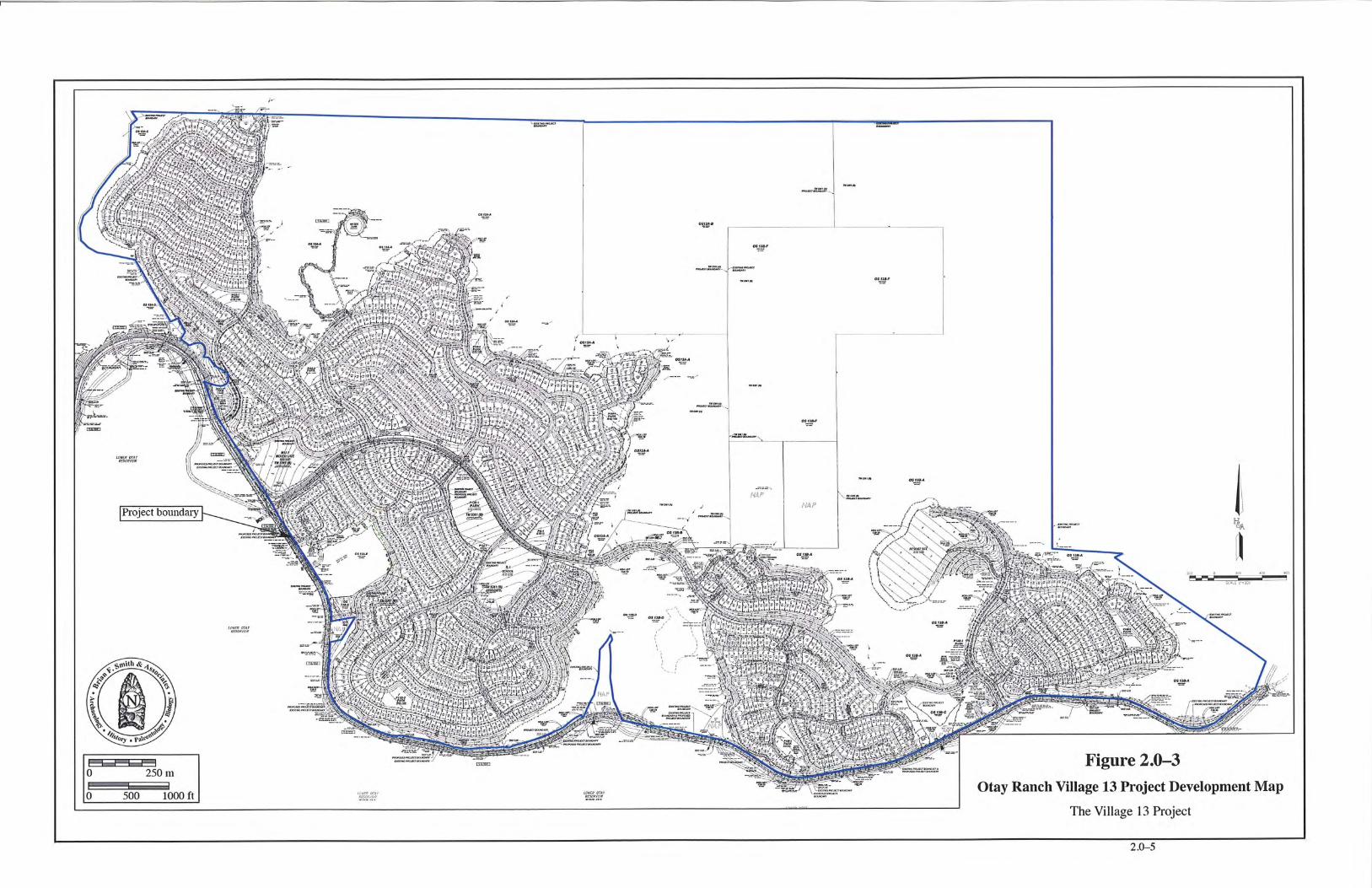

An Archaeological/Historical Study for the Otay Ranch Village 13 Project –––––––––––––––––––––––––––––––––––––––––––––––––––––––––––––––––––––––––––––––––––––––––––––––––––––––––––––––––––––
2.0–6
2.2 Scope of Current Study The following report describes an archaeological survey and site evaluation program for the 1,869-acre Otay Ranch Village 13 Project conducted by BFSA for JPB Development, LLC and Baldwin & Sons, LLC under the guidelines set forth by the County of San Diego. The archaeological study was conducted in accordance with the environmental guidelines of the County of San Diego and in compliance with CEQA.
Within the project boundaries, at least two previous archaeological surveys have been completed over the past 20 years: a survey conducted by RECON in 1989 (Ritz et al. 1989) and another survey conducted by Ogden in 1991 (Carrico et al. 1993). These surveys documented the presence of 39 cultural resources and numerous isolated finds within the project boundaries. None of these cultural resources has been previously evaluated for significance. The scope of work for the assessment of the potential impacts to cultural resources represented by the proposed development of the Otay Ranch Village 13 Project included a reconnaissance of previously unsurveyed areas and a review of those areas surveyed in 1991. The combination of intensive surveys and review of previously surveyed areas has resulted in an accurate inventory of archaeological sites within the Otay Ranch Village 13 Project. A total of 79 resources have been identified within the Otay Ranch Village 13 Project, 40 of which were identified during the current survey.
Prior to the current study, no significance evaluations had been performed as part of any CEQA process. In order to evaluate potentially adverse impacts represented by the development of Otay Ranch Village 13, a comprehensive site evaluation program was implemented. All resources that fall within the development envelope were subjected to a testing program consistent with County of San Diego guidelines. The testing program focused upon 69 sites that may be impacted by the development. Ten of the sites fall outside of the project development area and will not be directly impacted by the proposed development. Site boundaries were recorded for these 10 sites, but they were not subjected to a testing program. Since these sites have not been evaluated, they are assumed to be significant resources under CEQA guidelines. The testing program implemented at the 69 sites within the Otay Ranch Village 13 development area included surface collections of artifacts, shovel tests to determine the presence or absence of subsurface deposits, and one-square-meter test units that were used to sample subsurface deposits. All collected artifacts were returned to the laboratory at BFSA for cataloging and analysis. Testing of the 69 sites within the development area has resulted in the recommendation that 60 of the sites are considered to have limited significance; however, as the testing program has exhausted the potential for further important data from these locations, impacts to these sites will not be adverse and mitigation is considered complete with recordation, mapping, testing, and collection of artifacts. The remaining nine sites are recommended as significant under CEQA and County of San Diego guidelines, and are considered to retain additional research potential. These nine sites will be impacted by some elements of the proposed development project site;
An Archaeological/Historical Study for the Otay Ranch Village 13 Project –––––––––––––––––––––––––––––––––––––––––––––––––––––––––––––––––––––––––––––––––––––––––––––––––––––––––––––––––––––
2.0–7
these impacts will be adverse. Mitigation measures will be required to reduce the impacts to the nine sites to a level below significant. As stated above, the 10 sites located outside the Otay Ranch Village 13 development area were not tested during this investigation and, are therefore assumed to be significant under CEQA guidelines. All 10 sites will be placed in open space and will not be affected by the Otay Ranch Village 13 development.
In mid-2005, off-site improvements were proposed to widen Otay Lakes Road. An archaeological survey of all proposed off-site road improvements was conducted by BFSA. Based upon the survey and records search, no cultural resources are located within the off-site improvements corridor. Off-site surveys were also conducted for a portion of the sewer pipeline that may connect to the Spring Valley Sanitation District. No resources were identified along the off-site sewer survey.
All phases of work under this contract were directed by Brian F. Smith. The field and laboratory personnel consisted of Johnna Buysse, Charles Callahan, James Clifford, Kevin Hunt, Kent Smolik, Clarence Hoff, Marya Brookshire, Jennifer Bukey, Clint Callahan, Brad Comeau, Colleen DeCook, Mark Garrett, Jeff Henry, Richele Lake, Vanessa Matel, Scott Mattingly, Harry Moore, Richard Savitch, Jeff Szymanski, John Taylor, Michael Tuma, Kimberly Wade, Helen Wilson, and Nathanial Yerka. This report was written by Johnna Buysse and Brian Smith, with contributions by Larry Pierson, James Clifford, Sara Clowery-Moreno, Shannon Gilbert, Michael Tuma, and Kyle Guerrero. The graphics and production staff consisted of Robert Hernandez, Adrián Moreno, Clint Callahan, Nicole Benjamin-Ma, Alyson Berkowitz, Dylan Amerine, Kimberly Wade, and Roberta Klimas.
2.3 Applicable Regulations Resource importance is assigned to districts, sites, buildings, structures, and objects that
possess exceptional value or quality illustrating or interpreting the heritage of San Diego County in history, architecture, archaeology, engineering, and culture. A number of criteria are used in demonstrating resource importance. Specifically, criteria outlined in CEQA, the County of San Diego RPO, and the San Diego County Local Register provide the guidance for making such a determination. The following sections detail the criteria that a resource must meet in order to be determined important.
2.3.1 California Environmental Quality Act (CEQA)
According to CEQA (§15064.5a), the term “historical resource” includes the following: 1) A resource listed in, or determined to be eligible by the State Historical Resources
Commission, for listing in the California Register of Historical Resources (CRHR) (Pub. Res. Code §S5024.1, Title 14 CCR. Section 4850 et seq.).

An Archaeological/Historical Study for the Otay Ranch Village 13 Project –––––––––––––––––––––––––––––––––––––––––––––––––––––––––––––––––––––––––––––––––––––––––––––––––––––––––––––––––––––
2.0–8
2) A resource included in a local register of historical resources, as defined in Section 5020.1(k) of the Public Resources Code or identified as significant in an historical resource survey meeting the requirements of Section 5024.1(g) of the Public Resources Code, shall be presumed to be historically or culturally significant. Public agencies must treat any such resource as significant unless the preponderance of evidence demonstrates that it is not historically or culturally significant.
3) Any object, building, structure, site, area, place, record, or manuscript which a lead agency determines to be historically significant or significant in the architectural, engineering, scientific, economic, agricultural, educational, social, political, military, or cultural annals of California may be considered to be an historical resource, provided the lead agency’s determination is supported by substantial evidence in light of the whole record. Generally, a resource shall be considered by the lead agency to be “historically significant” if the resource meets the criteria for listing on the CRHR (Pub. Res. Code §S5024.1, Title 14, Section 4852) including the following:
a) Is associated with events that have made a significant contribution to the broad patterns of California’s history and cultural heritage;
b) Is associated with the lives of persons important in our past; c) Embodies the distinctive characteristics of a type, period, region, or
method of construction, or represents the work of an important creative individual, or possesses high artistic values; or
d) Has yielded, or may be likely to yield, information important in prehistory or history.
4) The fact that a resource is not listed in, or determined eligible for listing in the CRHR, not included in a local register of historical resources (pursuant to Section 5020.1(k) of the Public Resources Code), or identified in an historical resources survey (meeting the criteria in Section 5024.1(g) of the Public Resources Code) does not preclude a lead agency from determining that the resource may be an historical resource as defined in Public Resources Code Section 5020.1(j) or 5024.1.
According to CEQA (§15064.5b), a project with an effect that may cause a substantial
adverse change in the significance of an historical resource is a project that may have a significant effect on the environment. CEQA defines a substantial adverse change as:

An Archaeological/Historical Study for the Otay Ranch Village 13 Project –––––––––––––––––––––––––––––––––––––––––––––––––––––––––––––––––––––––––––––––––––––––––––––––––––––––––––––––––––––
2.0–9
1) Substantial adverse change in the significance of an historical resource means physical demolition, destruction, relocation, or alteration of the resource or its immediate surroundings such that the significance of an historical resource would be materially impaired.
2) The significance of an historical resource is materially impaired when a project:
a) Demolishes or materially alters in an adverse manner those physical characteristics of an historical resource that convey its historical significance and that justify its inclusion in, or eligibility for, inclusion in the CRHR; or
b) Demolishes or materially alters in an adverse manner those physical characteristics that account for its inclusion in a local register of historical resources pursuant to Section 5020.1(k) of the Public Resources Code or its identification in an historical resources survey meeting the requirements of Section 5024.1(g) of the Public Resources Code, unless the public agency reviewing the effects of the project establishes by a preponderance of evidence that the resource is not historically or culturally significant; or,
c) Demolishes or materially alters in an adverse manner those physical characteristics of an historical resource that convey its historical significance and that justify its eligibility for inclusion in the CRHR as determined by a lead agency for purposes of CEQA.
Section 15064.5(c) of CEQA applies to effects on archaeological sites and contains the
following additional provisions regarding archaeological sites: 1. When a project will impact an archaeological site, a lead agency shall first
determine whether the site is an historical resource, as defined in subsection (a). 2. If a lead agency determines that the archaeological site is an historical resource, it
shall refer to the provisions of Section 21084.1 of the Public Resources Code, Section 15126.4 of the Guidelines, and the limits contained in Section 21083.2 of the Public Resources Code do not apply.
3. If an archaeological site does not meet the criteria defined in subsection (a), but does meet the definition of a unique archaeological resource in Section 21803.2 of the Public Resources Code, the site shall be treated in accordance with the provisions of Section 21083.2. The time and cost limitations described in Public Resources Code Section 21083.2 (c-f) do not apply to surveys and site evaluation activities intended to determine whether the project location contains unique archaeological resources.

An Archaeological/Historical Study for the Otay Ranch Village 13 Project –––––––––––––––––––––––––––––––––––––––––––––––––––––––––––––––––––––––––––––––––––––––––––––––––––––––––––––––––––––
2.0–10
4. If an archaeological resource is neither a unique archaeological nor historical resource, the effects of the project on those resources shall not be considered a significant effect on the environment. It shall be sufficient that both the resource and the effect on it are noted in the Initial Study or EIR, if one is prepared to address impacts on other resources, but they need not be considered further in the CEQA process.
Section 15064.5 (d) & (e) contain additional provisions regarding human remains.
Regarding Native American human remains, paragraph (d) provides: (d) When an initial study identifies the existence of, or the probable likelihood, of
Native American human remains within the project, a lead agency shall work with the appropriate Native Americans as identified by the Native American Heritage Commission as provided in Public Resources Code §S5097.98. The applicant may develop an agreement for treating or disposing of, with appropriate dignity, the human remains and any items associated with Native American burials with the appropriate Native Americans as identified by the Native American Heritage Commission. Action implementing such an agreement is exempt from:
1) The general prohibition on disinterring, disturbing, or removing human
remains from any location other than a dedicated cemetery (Health and Safety Code Section 7050.5)
2) The requirement of CEQA and the Coastal Act.
2.3.2 San Diego County Local Register of Historical Resources (Local Register) The County requires that resource importance be assessed not only at the state level as
required by CEQA, but at the local level as well. If a resource meets any one of the following criteria as outlined in the Local Register, it will be considered an important resource:
1) Is associated with events that have made a significant contribution to the broad
patterns of San Diego County’s history and cultural heritage; 2) Is associated with the lives of persons important to the history of San Diego or its
communities; 3) Embodies the distinctive characteristics of a type, period, San Diego County
region, or method of construction, or represents the work of an important creative individual, or possesses high artistic values; or
4) Has yielded, or may be likely to yield, information important in prehistory or history.

An Archaeological/Historical Study for the Otay Ranch Village 13 Project –––––––––––––––––––––––––––––––––––––––––––––––––––––––––––––––––––––––––––––––––––––––––––––––––––––––––––––––––––––
2.0–11
2.3.3 Otay Ranch Phase 2 Resource Management Plan (RMP) Otay Ranch Village 13 (The Resort Project) is exempt from review under the County of
San Diego’s RPO because the project is part of the Otay Ranch RMP. The RMP has been created to provide a mechanism to manage a variety of resources within the context of a unified regional plan for the Otay Ranch area. For cultural resources within areas administered by the POM, the RMP states that archaeological site preservation is the preferred mitigation measure for cultural resources. When avoidance and preservation are feasible mitigation measures, sites will be preserved in open space areas designated as “The Preserve.” The RMP also provides for the implementation of data recovery plans for the mitigation of impacts where preservation is not feasible. (RMP, Page P-1).
2.4 Guidelines for Determining Significance Pursuant to the County of San Diego Guidelines for Determining Significance – Cultural
Resources (2007), any of the following will be considered a significant impact to cultural resources:
1) The project, as designed, causes a substantial adverse change in the significance of a
historical resource as defined in §15064.5 of the State CEQA Guidelines. This shall include destruction, disturbance, or any alteration of characteristics or elements of a resource that cause it to be significant in a manner not consistent with the Secretary of Interior Standards.
2) The project, as designed, causes a substantial adverse change in the significance of an archaeological resource pursuant to §15064.5 of the State CEQA Guidelines. This shall include the destruction of disturbance of an important archaeological site or any portion of an important archaeological site that contains or has the potential to contain information important to history or prehistory.
3) The project disturbs any human remains, including those interred outside of formal cemeteries.

An Archaeological/Historical Study for the Otay Ranch Village 13 Project –––––––––––––––––––––––––––––––––––––––––––––––––––––––––––––––––––––––––––––––––––––––––––––––––––––––––––––––––––––
3.0–1
3.0 PROJECT SETTING AND BACKGROUND RESEARCH
The project setting includes the natural physical, geological, and biological contexts of the proposed project, as well as the cultural setting of prehistoric and historic human activities in the general area. The following section discusses both the environmental and cultural settings at the subject property, the relationship between the two, and the relevance of that relationship to the project. 3.1 Environmental Setting The proposed Otay Ranch Village 13 Project is located on the southwestern slopes of the Jamul Mountains, north of Lower Otay Reservoir and east of Upper Otay Reservoir, in Townships 17 and 18 South, Ranges 1 West and 1 East, entirely within the USGS Jamul Mountains Quadrangle (Figures 2.0–1 and 2.0–2). The project’s 1,869-acre planning area consists of a broad mesa sloping to the south, broken by several steep canyons draining from north to south. Portions of the relatively flat mesa extend north into the Jamul Mountains, becoming part of steeper slopes. Site elevations range from approximately 500 feet AMSL at the southern end of the property to approximately 1,500 feet AMSL in the northeastern portions. The project area lies within the watershed of the Otay River, a westerly flowing stream that drains an area of approximately 145 square miles. The site is upstream of Savage Dam, which creates Lower Otay Lake. Vegetation consists of native coastal sage scrub and grassland habitats disturbed by grazing. Some riparian vegetation occurs in drainage areas of the site. Land use patterns in historic and recent periods have included agricultural activities, including cattle grazing and cultigens, which have affected the native vegetation communities that once existed in these areas (Beauchamp 1986). 3.1.1 Physical Environment The region surrounding the project encompasses a system of igneous and sedimentary geological formations. The project itself is situated on the moderately steep, lower slopes of the Jamul Mountains, with San Miguel Mountain to the northwest and the San Ysidro Mountains to the south. The area is bisected by large river valleys, including Jamul Valley directly south of the project and Proctor Valley to the northwest of the project, as well as numerous smaller seasonal drainages. The Jamul Mountains and surrounding foothills are composed of Jurassic volcanics, a collection of mildly metamorphosed volcanic and volcanoclastic rock formations, characterized by the Black Mountain or Santiago Peak Volcanics (Biehler 1979). Santiago Peak Volcanics are represented throughout this area of San Diego County by outcrops of basalt and andesite. This formation contains a fine-grained, green metavolcanic known locally as felsite, which was utilized by Native Americans for the manufacture of tools. To the west of the project area is Otay Mesa, a geologic mass consisting of a series of knolls and mesas that are cut by

An Archaeological/Historical Study for the Otay Ranch Village 13 Project –––––––––––––––––––––––––––––––––––––––––––––––––––––––––––––––––––––––––––––––––––––––––––––––––––––––––––––––––––––
3.0–2
small canyons and drainages located in the Coastal Plains Physiographic Province. Much of this area is composed of Pliocene marine and marine terrace deposits, known as the Otay and San Diego formations (Kennedy and Tan 1977). The San Diego Formation is composed of gray friable sandstone and conglomerate. The Otay Formation underlies the San Diego and consists of bentonitic clays. The juncture of the coastal plain to the west and the foothill area where the Otay Ranch Village 13 Project is located is composed of Plio-Pleistocene, nonmarine deposits typically consisting of angular metavolcanic detritus. The project area also includes a variety of soils. The lower elevations consist primarily of Olivenhain soils including well-drained, moderately deep to deep cobbly loams that have a very cobbly clay subsoil (Bowman 1973). The higher elevations within the project area exhibit primarily Friant soils, which consist of shallow and very shallow, well-drained fine sandy loams that formed in material weathered from fine-grained metasedimentary rock. Other soil types mapped within the project area include San Miguel/Exchequer and Redding series soils. Metavolcanic bedrock, primarily that of fine- and medium-grained material, is exposed throughout the project area. 3.1.2 Biological Environment The biological setting of the project area is characterized by native coastal sage scrub communities in the canyons and slopes on the north and east portions of the project, while the level areas on the southern portion have plant communities associated with post-agricultural uses. These communities are heavily dependent on the amount of precipitation that the area receives. The amount of seasonal precipitation is related to the major landforms that exist throughout the county. Coastal mesas, such as Otay Mesa to the west, receive an average of between 12 and 16 inches (30 to 40 centimeters) of rainfall annually, mostly between October and May (Beauchamp 1986). The project area also exhibits generally mild temperatures; however, several instances of winter frost, as well as some weeks in the summer with temperatures of over 100 Degrees Fahrenheit, are recorded annually. These environments tend to support a wide variety of wildlife, particularly birds and small mammals (Beauchamp 1986). 3.1.3 Current Land Use The project area has been utilized for farming and grazing since the first land grants were made in the early 1800s. In recent years, the property has been leased to ranchers for cattle grazing. None of the project area has been developed, but many improved dirt roads cross the property. 3.2 Cultural Setting The cultures that have been identified in the general vicinity of the project consist of the possible Paleo Indian manifestation of the San Dieguito Complex, the Archaic La Jolla Complex, and the Late Prehistoric Kumeyaay culture. The area was used for ranching and farming

An Archaeological/Historical Study for the Otay Ranch Village 13 Project –––––––––––––––––––––––––––––––––––––––––––––––––––––––––––––––––––––––––––––––––––––––––––––––––––––––––––––––––––––
3.0–3
following the Hispanic intrusion into the region, and extending into the historic period. A brief discussion of the cultural elements in the project area is provided in the following subsections. 3.2.1 Paleoenvironment Because of the close relationship between prehistoric settlement and subsistence patterns and the environment, it is necessary to understand the setting in which these systems operated. At the end of the final period of glaciation, approximately 11,000 to 10,000 years before the present (YBP), the sea level was considerably lower than it is now; the coastline at that time would have been between two and two and one-half miles west of its present location (Smith and Moriarty 1985a, 1985b). At approximately 7,000 YBP, the sea level rose rapidly, filling in many coastal canyons that had been dry during the glacial period. The period between 7,000 and 4,000 YBP was characterized by conditions that were drier and warmer than previously, followed by a cooler, moister environment similar to the present-day climate (Robbins-Wade 1990). Changes in sea level and coastal topography are often manifested in archaeological sites in the types of shellfish that were utilized by prehistoric groups. Different species of shellfish prefer certain types of environments; dated sites that contain shellfish remains reflect the setting that was exploited by the prehistoric occupants. Unfortunately, pollen studies have not been conducted for this area of San Diego; however, studies in other areas of southern California, such as Santa Barbara, indicate that the coastal plains supported a pine forest between approximately 12,000 and 8,000 YBP (Robbins-Wade 1990). After 8,000 YBP, this environment was replaced by more open habitats, which supported oak and non-arboreal communities. The coastal sage scrub and chaparral environments of today appear to have become dominant after 2,200 YBP (Robbins-Wade 1990). 3.2.2 Prehistory The San Dieguito Complex The San Dieguito Complex was a group of people who occupied sites in this region between 10,000 and 8,000 YBP. They were related to or contemporaneous with the Paleo Indian groups in the Great Basin area and the Midwest. The artifacts recovered from San Dieguito sites duplicate the typology attributed to the Western Pluvial Lakes Tradition (Moratto 1984; Davis et al. 1969). These artifacts generally consist of scrapers and scraper planes, choppers, and bifacially flaked knives, but few or no milling tools. The absence of grinding or milling stones suggests that cereal grains and nuts were not part of the subsistence pattern. Tools recovered from sites of the San Dieguito Complex and the general pattern of site locations indicate that they were a wandering, hunting, and gathering society (Moriarty 1969; Rogers 1966). The San Dieguito Complex is the least understood of the cultures that have inhabited San Diego County. This is primarily due to the fact that San Dieguito sites rarely contain stratigraphic information or datable material. There is a current controversy among researchers centering on the relationship of the San Dieguito and the subsequent cultural manifestation in the

An Archaeological/Historical Study for the Otay Ranch Village 13 Project –––––––––––––––––––––––––––––––––––––––––––––––––––––––––––––––––––––––––––––––––––––––––––––––––––––––––––––––––––––
3.0–4
area, the La Jolla Complex. Firm evidence has not yet been discovered to indicate whether the San Dieguito “evolved” into the La Jolla Complex, the La Jolla Complex moved into the area and assimilated the San Dieguito people, or the San Dieguito retreated from the area because of environmental or cultural pressures. Very little evidence of the San Dieguito Complex has been identified within the project area. It is probable that environmental changes associated with climatic change affected the subsistence base of the San Dieguito Complex, resulting in their exodus from this area sometime before 9,000 YBP. The La Jolla Complex Approximately 9,000 to 8,500 YBP, a second major cultural tradition was established in the San Diego region, primarily along the coast. At that time, the shoreline was located farther west than it is currently, because the sea level was lower during the end of the last Ice Age. Locally, this cultural tradition has been called the La Jolla Complex, and radiocarbon dates from sites attributed to this culture span a period of over 7,000 years in this region (between 9,000 and 2,000 YBP). The La Jolla Complex is best recognized for its pattern of shell middens, grinding tools closely associated with marine resources, and flexed burials (Shumway et al. 1961; Smith and Moriarty 1985a, 1985b). The tool typology of the La Jolla Complex displays a wide range of sophisticated lithic manufacturing techniques. Scrapers, the most common type of flaked tool recovered from La Jolla sites, were created by either splitting cobbles or finely flaking quarried material. La Jolla sites also contain large numbers of milling tools (manos and metates) and utilized flakes that appear to have been used to pry open shellfish (Smith and Moriarty 1985a, 1985b). Inland sites of the La Jolla Complex, sometimes called the Pauma Complex, were situated at a distance from marine food resources and generally lack marine-related refuse. But they do contain large quantities of milling tools and food bone, suggesting seasonal migration from the coast to the inland valleys (Smith 1986). The Late Prehistoric Kumeyaay Indians The last major migration into the coastal zone occurred approximately 1,500 YBP, when Yuman- and Shoshonean-speaking people moved from the Colorado River Basin to the coast in search of a more plentiful food supply (Moriarty 1969). This group is known locally as the Late Prehistoric Diegueño, or Kumeyaay, culture. Fortunately, ethnographic evidence is available from the period of the earliest Spanish contact to the late 1800s, providing a record of the nonmaterial aspects of these groups. Sites associated with the Kumeyaay are focused in the foothills and mountains, rather than along the coast. Their subsistence pattern was based upon the collection of seeds (especially acorns), berries, and bulbs, and the hunting of small game. Artifact collections from Late Prehistoric occupations include milling tools, ceramics, projectile points, scrapers, planes, beads, shaft straighteners, and hammerstones. Ethnographic information indicates that the

An Archaeological/Historical Study for the Otay Ranch Village 13 Project –––––––––––––––––––––––––––––––––––––––––––––––––––––––––––––––––––––––––––––––––––––––––––––––––––––––––––––––––––––
3.0–5
culture of the Kumeyaay Indians consisted of a close clan system with definitive religious beliefs and complex trade associations with relatives living in the Colorado River Basin (Kroeber 1925). The last phase of the Kumeyaay culture began approximately 400 YBP, with the first contact by Europeans (Juan Rodriguez Cabrillo, in 1542). By 1769, at the time of the first European settlement in San Diego, at least 20 permanent or semi-permanent villages had been established near the Pueblo of San Diego. These living sites were primarily coastal, although some were located in valleys that were a short distance inland. For the most part, villages were located close to a supply of fresh water and plant foods. Villages that depended on springs for their water supply were usually located some distance from them, so that the animals using them would not be driven off, and also to avoid the insects that frequented the surrounding marshy areas (Moriarty 1961). Historical accounts generally agree that a few villages were located along the bay side of Point Loma, and several were scattered along the shores of Mission Bay. Others were situated in the present area of the city of San Diego and near the mouths of the major streams that emptied into San Diego Bay. Major river valleys, such as the San Diego River Valley, were well populated because of their plant foods and water resources . Villages were also located in the La Jolla area, in Soledad Canyon, at the mouth of Rose Canyon, and in the inland valleys of the Otay Mesa, east of San Diego. A number of temporary shellfish gathering and fishing sites were situated on the shores of bays and the ocean.
3.2.3 Native American Perspective In addition to the point of view discussed above, the County acknowledges that other
perspectives exist to explain the presence of Native Americans in the region. The Native American perspective is that they have been here from the beginning, as described by their creation stories. Similarly, they do not necessarily agree with the distinction that is made between different archaeological cultures or periods, such as “La Jolla” or “San Dieguito.” They instead believe that there is a continuum of ancestry, from the first people to the present Native American populations of San Diego. To acknowledge this perspective, consultation with affected Native American communities can be beneficial to fully understand the impact to cultural resources. The consultation is typically administered pursuant to Senate Bill 18.
3.2.4 History Exploration Period (1530 to 1769) The historic period around San Diego Bay began with the landing of Juan Rodriguez Cabrillo and his men in 1542. Previous expeditions sent out by Hernando de Cortés, the conqueror of Mexico, had discovered the tip of Baja California in the early 1530s. Subsequent voyages at his direction gradually defined the Gulf of California by recording the shores of Baja California and the Mexican mainland. These discoveries directed attention to the coast of Alta California. Sixty years after the Cabrillo expeditions, an expedition under Sebastian Vizcaíno made an extensive and thorough exploration of the Pacific coast. Although the voyage did not

An Archaeological/Historical Study for the Otay Ranch Village 13 Project –––––––––––––––––––––––––––––––––––––––––––––––––––––––––––––––––––––––––––––––––––––––––––––––––––––––––––––––––––––
3.0–6
extend beyond the northern limits of the Cabrillo tract, Vizcaíno had the most lasting effect on the nomenclature of the coast. Many of the names he gave to places have survived, whereas practically every one of Cabrillo’s has faded from use. Cabrillo’s voyage gave cartographers the information that they needed to begin defining the western shores of the unknown land located north of Mexico. Subsequent voyages added details to Cabrillo’s information that, in time, permitted the mapmakers to accurately depict the west coast. As the newer reports came in, the names that Cabrillo gave to various places were gradually supplanted. Because his voyage was the last one, Vizcaíno’s names became fixed in the mapmakers’ minds, and thus survived (Rolle 1969). Cabrillo gave the name of “San Miguel” to the first port at which he stopped in what is now the United States; 60 years later, Vizcaíno changed it to “San Diego” (Rolle 1969). Spanish Period (1769 to 1821) The Spanish occupation of the claimed territory of Alta California took place during the reign of King Carlos III of Spain. The powerful representative of the King in Mexico was Jose de Galvez, who conceived of the plan to colonize Alta California and thereby secure the area for the Spanish crown (Rolle 1969). The effort involved both a military and a religious contingent, with the overall intent of establishing forts and missions to gain control of the land and of the native inhabitants through conversion. Actual colonization of the San Diego area began on July 16, 1769, when the first Spanish exploring party, commanded by Gaspar de Portolá (with Father Junípero Serra in charge of religious conversion of the native populations), arrived in San Diego to secure California for the Spanish crown (Palou 1926). The natural attraction of the harbor at San Diego and the establishment of a military presence in the area solidified the importance of San Diego to the Spanish colonization of the region and the growth of the civilian population. Missions were constructed from San Diego to as far north as San Francisco. The mission locations were based upon a number of important territorial, military, and religious considerations. As an extension of territorial control by the Spanish empire, each mission was placed so as to command as much territory and as large a population as possible. The route of El Camino Real served as the primary channel within which to funnel transportation, commercial, and military activities, and eventually railroads northward along the coast. This route was considered to be the most direct path between the missions (Rolle 1969). As increasing numbers of Spanish and Mexican peoples, and later Americans during the Gold Rush, settled in the area, the Indian populations diminished as they were displaced or decimated by disease (Carrico and Taylor 1983). Mexican Period (1821 to 1846) By 1821, Mexico had gained independence from Spain, and the northern territories were subject to political repercussions. By 1834, all of the mission lands had been removed from the control of the Franciscan Order under the Acts of Secularization. Without proper maintenance, the missions quickly began to disintegrate, and after 1836, missionaries ceased to make regular

An Archaeological/Historical Study for the Otay Ranch Village 13 Project –––––––––––––––––––––––––––––––––––––––––––––––––––––––––––––––––––––––––––––––––––––––––––––––––––––––––––––––––––––
3.0–7
visits inland (Engelhardt 1920). The mission lands were divided into smaller tracts, or ranchos, which were granted to persons who had gained favor with the Mexican government. Such grants are located directly east (Rancho Jamul) and southwest (Ranchos Otay and Janal) of the Otay Ranch Village 13 Project (see Section 3.3 for a brief rancho history). Anglo-American Period (1846 to Present) California was invaded by United States troops during the Mexican War of 1846 to 1848. The acquisition of strategic Pacific ports and California land was one of the United States’ principal objectives of the war (Price 1967). At the time, the inhabitants of California were practically defenseless, and they quickly surrendered to the United States Navy in July of 1847 (Bancroft 1886). The cattle ranchers of the “counties” of southern California had prospered during the cattle boom of the early 1850s. They were able to “reap windfall profit...pay taxes and lawyer’s bills...and generally live according to custom” (Pitt 1966). Cattle ranching soon declined, however, contributing to the expansion of agriculture. With the passage of the “No Fence Act,” San Diego’s economy changed from stock raising to farming (Rolle 1969). The act allowed for the expansion of unfenced farms, which was crucial in an area where fencing material was practically unavailable. Five years after its passage, most of the farmlands in San Diego County had been patented, and growing grain crops replaced raising cattle in many of the county’s inland valleys (Blick 1976; Elliott 1883 [1965]). By 1870, farmers had learned to dry farm and were coping with some of the peculiarities of San Diego County’s climate (San Diego Union, February 6, 1868; Van Dyke 1886). Between 1869 and 1871, the amount of cultivated acreage in the county rose from less than 5,000 to more than 20,000 acres (San Diego Union, January 2, 1872). Of course, droughts continued to hinder the development of agriculture (Crouch 1915; San Diego Union, November 10, 1870; Shipek 1977). Large-scale farming in San Diego County was limited by a lack of water and the small size of farm valleys; also, the small urban population and poor roads restricted commercial crop growing. Nevertheless, cattle continued to be grazed in inland San Diego County. For example, in the Otay Mesa area, the “No Fence Act” had little effect, because ranches were still spaced far apart, and natural features helped keep the cattle out of growing crops (Gordinier 1966). During the first two decades of the twentieth century, the population of San Diego County continued to grow. The population of the inland county declined during the 1890s, but between 1900 and 1910, it rose by about 70 percent. The pioneering efforts were over, the railroads had broken the relative isolation of southern California, and life in San Diego County became similar to other communities throughout the west. After World War I, the history of San Diego County was primarily determined by the growth of San Diego Bay. In 1919, the United States Navy decided to make San Diego Bay the home base for the Pacific Fleet (Pourade 1967) and during the 1920s, the aircraft industry followed suit (Heiges 1976). The establishment of these industries led to the growth of the county as a whole; however, most of the growth

An Archaeological/Historical Study for the Otay Ranch Village 13 Project –––––––––––––––––––––––––––––––––––––––––––––––––––––––––––––––––––––––––––––––––––––––––––––––––––––––––––––––––––––
3.0–8
occurred in the north county coastal areas, where the population almost tripled between 1920 and 1930. During this time, the history of inland San Diego County was subsidiary to that of the city of San Diego, which became a Navy center and industrial city (Heiges 1976). In inland San Diego County, agriculture became specialized, and recreational areas were established in the mountains and deserts. Just before World War II, urbanization began to spread to the inland county, including the area of eastern Chula Vista that contains the current study area.
3.3 Rancho History The area of Otay Ranch Village 13 lies between two Mexican-era ranchos and a circa-1897 water storage and distribution system. The Ranchos of Otay (Dominguez), later called Rancho Janal and Rancho Jamul, were large land grants to private citizens dating to the Hispanic period in California. Mission San Diego de Alcalá may have used this land for grazing mission herds prior to the land grants, but no specific ethnohistoric evidence was found to support this idea. In 1829, Mexican Governor José María Echeandía granted both ranchos to private citizens. Rancho Janal went to Don José Antonio Estudillo, who built Casa Estudillo in Old Town San Diego (Moyer 1969). Rancho Jamul was granted to Pio Pico, who also served as Mexico’s last governor of California.
Land use on the ranchos consisted of grazing livestock and raising crops such as winter wheat for export (Caughey 1970). Hay, corn, beans, squash, tomatoes, peppers, olives for oil and for the table, grapes to make wine and for the table, and other staples were grown for local use. The rancho owners spent much of their time at their respective houses in Old Town, visiting the ranchos periodically for management purposes and for recreation. The two ranchos discussed here survive largely intact to this day.
Elisha S. Babcock, who was part of the syndicate that developed Coronado and the Hotel del Coronado, purchased the Janal Rancho and was involved in creating the Southern California Mountain Water Company (Smythe 1908). That water company created the upper and lower Otay reservoirs as part of its water storage and delivery system. Mr. Babcock became sole owner of the Hotel del Coronado and sold the hotel, Rancho Janal, and the water company to John D. Spreckels after convincing him to invest in San Diego. Rancho Janal became the site of hunting lodges for guests at the Hotel del Coronado. One of these later became the home of Stephen Birch, who purchased Rancho Otay (Estudillo) or Otay Ranch. A later owner was Mary Birch Patrick, the surviving family member and owner/operator of nearby Otay Ranch.
The importance of the Southern California Mountain Water Company to this project is the fact that Lower Otay Reservoir flooded a town site that was the focus for early settlement in the southernmost portion of Otay Ranch Village 13. The town site was El Nido (Spanish for “the nest”), which at one time boasted a general store, a post office branch, and a school. Information regarding this location was found at the San Diego Historical Society Research Archives in Balboa Park. The most useful document relating to the town of El Nido was the typescript of a
An Archaeological/Historical Study for the Otay Ranch Village 13 Project –––––––––––––––––––––––––––––––––––––––––––––––––––––––––––––––––––––––––––––––––––––––––––––––––––––––––––––––––––––
3.0–9
1959 interview with Vibert Marcus Mossholder, the son of the storekeeper and postmaster at El Nido.
Mr. Mossholder moved from Chula Vista to El Nido with his parents and provided recollections of the El Nido area from his youth. “No grain was raised, mostly fruit trees and bees. The others back in the mountains raised some vegetables for themselves and hay for their own horses. The Southern California Mountain Water Company bought out the places in El Nido with a combination of real estate and cash. There had been no church in El Nido.” The San Diego Newspaper microfiche file had a single entry for El Nido, indicating that it “…was covered with timber along the Otay Creek. Near the famous Harvey orange grove (Harvey Ranch).”
Two additional data sources provided some information on the date and location of El Nido. A post office history identified El Nido as being established on August 27, 1888, then moved one mile southeast on April 28, 1899, and later discontinued on August 15, 1900 (Salley 1977). The post office was located eight miles south of Jamul in the southwest quarter of Section 5, Township 18 South, Range 1 East; the first postmaster was August M. Stein. A local history identified the original line of travel to El Nido as via Otay Lakes Road (Schmid 1963). This history was obviously written after the lakes were formed. Schmid went on to describe El Nido as a post office, a school, and a store along San Ysidro (sic) Creek between Janal and Jamul ranchos. Schmid said the settlement had vanished with the construction of Lower Otay Dam by E.S. Babcock in 1897, but scattered groups of trees marking home sites of the old ranches are seen around the lake.
Within the project boundaries, only one early homestead was recorded during the life of El Nido (Figure 3.3–1). That homestead was patented under the 1862 Homestead Act to James H. Thompson for the eastern half of the southwest quarter, the southeast quarter of the northwest quarter, and the southwest quarter of the northeast quarter of Section 32, Township 17 South, Range 1 East of the San Bernardino Meridian (Bureau of Land Management Land Patent Records). Because the Assessor’s building records for the first half of the nineteenth century were not on file at the Assessor’s Branch Office in Chula Vista for parcels within the project, little additional information was forthcoming about this period of homesteading and subsequent farming/ranching. Moreover, the total quantity of land controlled by Mr. Thompson and the location of his primary dwelling has not been determined. The requirements of the 1862 Homestead Act included five years occupation by the patentee, cultivation, and improvement as conditions of the patent. Archaeological evidence gathered during the field investigation identified partial foundations that may represent the Thompson Homestead.
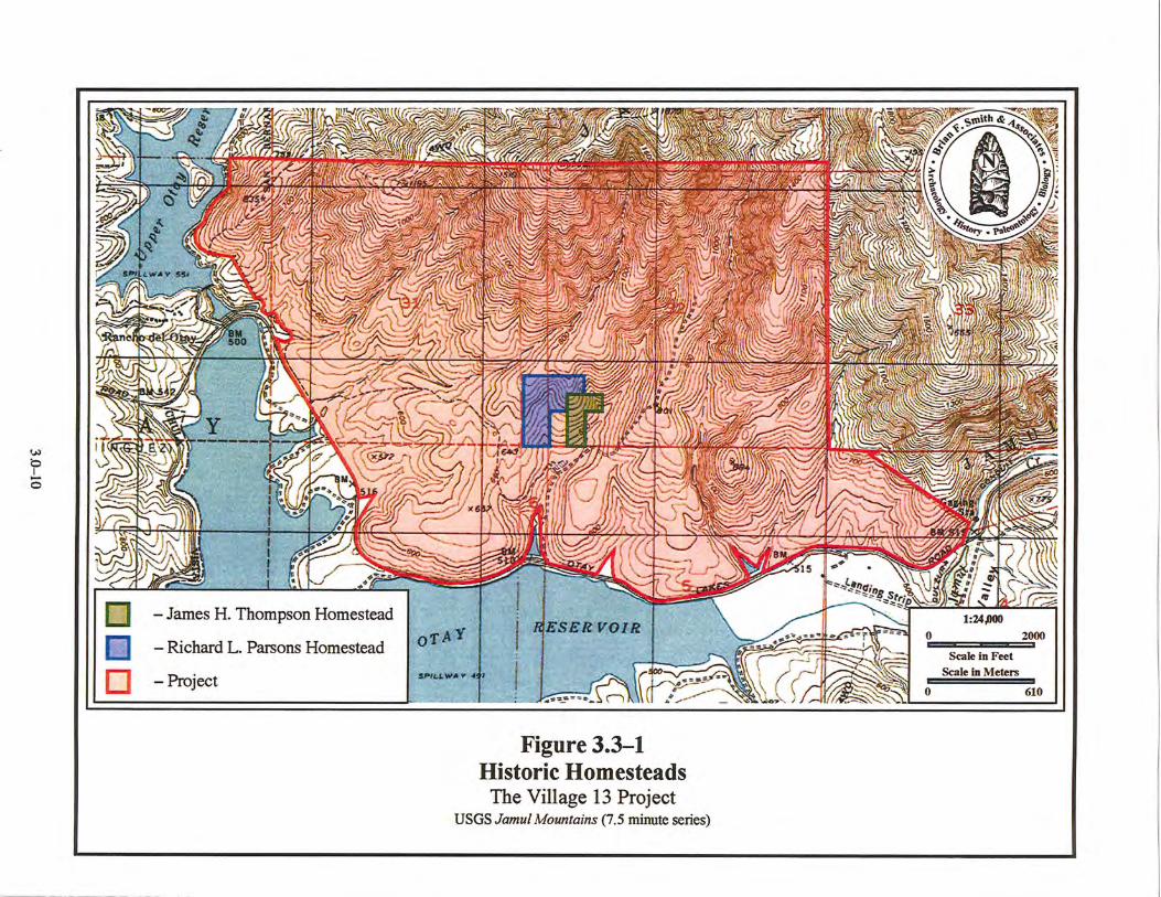

An Archaeological/Historical Study for the Otay Ranch Village 13 Project –––––––––––––––––––––––––––––––––––––––––––––––––––––––––––––––––––––––––––––––––––––––––––––––––––––––––––––––––––––
3.0–11
Another homestead taken under the 1862 Homestead Act was granted to Richard L. Parsons in 1933, a date much later than was normal for homestead filings under that act. This homestead included Lots 1 and 2 of Section 31, Township 17 South, Range 1 East. This part of the homestead was filed for the remainder of Section 31 east of the Janal Rancho boundary. The Parsons Homestead also included the contiguous northern half of the northwest quarter and the southwest quarter of the northwest quarter of Section 32. This location was adjacent to the Thompson Homestead of a generation earlier. No archaeological evidence of the Parsons Homestead residence could be located during fieldwork for this project.
Two other data sources for historic period archaeological resources at the project were the original township plats for the project and the 1928/1929 aerial photograph series. The original township plat for Township 18 South, Range 1 East shows several houses, which included the Janal Rancho structures and private residences to the east. A dam is also present on Otay Creek within the Rancho Janal, but in a different location than the present Lower Otay Dam. The 1928/1929 aerial photograph shows only a single location on a hilltop where an obvious historic site is located (Plate 3.3–1). That residence location was identified on the ground during the archaeological survey of this project. The location is not within either of the homesteads, but may have been related if either one of the homesteaders controlled additional parcels through purchase or leasehold, as was often the case.
Additional project-specific historic information could be forthcoming for the first half of the twentieth century if the original tax roll ledgers could be located. Another potential information source is the older Assessor’s building records, which may be in archival storage. Last, but not least, would be a chain of title, which would identify how much land beyond the original patents was owned by the two homesteaders at the project. These records have the potential to identify not only what the ownership pattern of land was through time, but the assessment rolls could identify the particular parcels where buildings had been located.
For the first half of the twentieth century, land use at the project appears to be limited to grazing of livestock. In the project area, it was common for hay to be grown for local consumption, but livestock grazing predominated the land use. Artificial irrigation allowed some production of row crops and it is known that lima beans and grains were produced in abundance on both the Otay and Janal ranches (Pierson 2000). More recently, development of the area for residential communities and for the Olympic Training Center has taken place. The present project is an eastward extension of that trend.


An Archaeological/Historical Study for the Otay Ranch Village 13 Project –––––––––––––––––––––––––––––––––––––––––––––––––––––––––––––––––––––––––––––––––––––––––––––––––––––––––––––––––––––
3.0–13
3.4 Records Search and Previous Studies Cultural resource records searches for this project were conducted at the SSCIC at SDSU
and requested of the Native American Heritage Commission’s (NAHC) Sacred Lands Files (SLF). The records search conducted at the SCIC revealed that two previous studies included cultural resources surveys of the area delineated as Otay Ranch Village 13. These previous surveys are part of the initial 13,088-acre Otay Ranch EIR completed in 1993. The Ogden (Carrico et al. 1992) and RECON (Ritz et al. 1989) studies were both conducted in association with earlier phases of the development of the Otay Ranch (Table 3.4–1). Thirty-nine cultural resources and a number of isolates were identified within project boundaries as a result of these studies (Table 3.4–2). The records search conducted at the SCIC confirmed the presence and recorded status of these 39 sites (Appendix I).
The records search also showed that an additional 18 cultural resource studies have been conducted for properties within a one-mile radius of the current project area. A complete list of these studies is presented in Table 3.4–1. Furthermore, the records search showed that an additional 61 cultural resources and a number of isolates have been previously recorded within a mile of the current project area. The majority of these sites are prehistoric in nature (N=36), consisting of lithic scatters, bedrock milling sites, and quarry/resource procurement areas. Fourteen sites within a one-mile radius were historic, and consisted of the remains of historic structures, foundations, rock piles, and refuse debris. Another 11 sites showed both historic and prehistoric components. The records searches demonstrated a strong presence of Archaic people in the Otay Ranch Village 13 area roughly after 6,000 YBP, and then an influx of Late Prehistoric use after 1,500 YBP. A summary of these sites is presented in Table 3.4–2. The complete records search results are presented in Appendix I.
Previous studies in the project area are generally focused on land west of Otay Ranch Village 13. Development of Villages 1 through 11 of Otay Ranch, west of lower Otay Reservoir, as well as Rolling Hills Ranch (Salt Creek) and Rancho San Miguel, have resulted in several cultural resource surveys, testing programs, and data recovery programs as land is processed for development. The study of cultural resources as part of the environmental review of development projects has resulted in a significant expansion of archaeological data and knowledge concerning the prehistoric use of this region.
Although the SLF records search resulted in the determination of the presence of Native American cultural resources that may be impacted by the Otay Ranch Village 13 Project, the location of these resources could not be revealed by the NAHC. No response regarding any known cultural resources within the project was received from inquiry letters submitted to local Native American representatives (see Section 5.5 and Appendix IV). The County of San Diego has conducted Senate Bill 18 consultation with those tribal representatives who expressed an interest or concern about the development on land encompassed by Otay Ranch Village 13. Correspondence and other information related to Native American issues is provided in Appendix IV.

An Archaeological/Historical Study for the Otay Ranch Village 13 Project –––––––––––––––––––––––––––––––––––––––––––––––––––––––––––––––––––––––––––––––––––––––––––––––––––––––––––––––––––––
3.0–14
TABLE 3.4–1 Previous Archaeological Investigations Conducted Within a One-Mile Radius of the Otay Ranch Village 13 Project
American Pacific Environmental Consultants, Inc.
1979 Hillside Development Policy Report, Complete Survey and Archaeological Investigation on Kleinman Property TPM 16326, Log# 79-14-248. American Pacific Environmental Consultants, Inc. Submitted to David Kleinman. Unpublished report on file at SCIC.
American Pacific Environmental Consultants, Inc.
1979 Morena Lake Development TPM 15326 EAD Log# 78-21-19 San Diego County, California. American Pacific Environmental Consultants, Inc. Submitted to Morena Lake Development. Unpublished report on file at SCIC.
Archaeological Planning Collaborative
1980 An Archaeological Records Search and Field Survey of the Janal Ranch Survey. Archaeological Planning Collaborative. Submitted to Larry Seeman Associates. Unpublished report on file at SCIC.
Buysse, Johana L., and Brian F. Smith
2003 Archaeological Mitigation of Impacts to Prehistoric Site SDI-7976 For the III Woods Project: City of Chula Vista. Brian F. Smith and Associates. Submitted to the Eastlake Company, LLC. Unpublished report on file at SCIC.
Carrico, Richard L., Theodore G. Cooley, and Andrew Pigniolo
1993 Final Cultural Resources Evaluation of the 23,088-Acre Otay Ranch, San Diego County. Ogden Environmental. Submitted to City of Chula Vista. Unpublished report on file at SCIC.
Chace, Paul G.
1983 An Archaeological Survey of the Honey Springs Off-Site Water Line Appendix VI to the Archaeology of Honey Springs, San Diego County (1980) (EAD Log #81-19-24). Paul G. Chace & Associates. Submitted to Presenting, A California Corporation. Unpublished report on file at SCIC.
Cooley, Theodore G.
1989 Cultural Resource Testing of a Portion of the Janal/Fenton Ranch-Parcel #1, for KELCO, Division of Merck & Company. ERC Environmental and Energy Services Company. Submitted to KELCO Division of Merck & Company, Inc. Unpublished report on file at SCIC.

An Archaeological/Historical Study for the Otay Ranch Village 13 Project –––––––––––––––––––––––––––––––––––––––––––––––––––––––––––––––––––––––––––––––––––––––––––––––––––––––––––––––––––––
3.0–15
County of San Diego Department of Planning & Land Use 1988 Draft Environmental Impact Report Sweetwater Community Plan Update GPA
88-03. County of San Diego Department of Planning & Land Use. Submitted to unknown. Unpublished report on file at SCIC.
Duke, Curt
2002 Cultural Resource Assessment AT&T Wireless Services Facility No. I008IA-02 San Diego County, California. LSA Assoc. Submitted to Geotrans. Unpublished report on file at SCIC.
Gallegos, Dennis; Roxana Phillips, Carolyn Kyle and Andrew Pigniolo
1989 Cultural Resource Testing Program for Eastlake III, Chula Vista, California. ERCE. Submitted to City of Chula Vista. Unpublished report on file at SCIC.
Hector, Susan
1988 Addendum to Archaeological Survey Report on the Daley Rock Quarry Jamul Valley. Susan Hector. Submitted to Daley Enterprises. Unpublished report on file at SCIC.
Kyle, Carolyn
2000 Cultural Resource Survey for the Otay Water Treatment Plant Upgrade City of San Diego, California. Kyle Consulting. Submitted to Helix Environmental Planning, Inc. Unpublished Report on file at SCIC.
May, Ron
1991 Otay Survey. Ron May. Submitted to Richard Carrico. Unpublished report on file at SCIC.
McIntyre, Bruce
1992 Volume II Appendices to the Draft Environmental Impact Report for the Proposed Daley Enterprises Rock Quarry MUP Modification. ERC Environmental and Energy Services Company. Submitted to Daley Enterprises. Unpublished Report on file at SCIC.
Ogden Environmental and Energy Services Co., Inc.
1992 Draft Program Environmental Impact Report. Otay Ranch. Ogden Environmental and Energy Services Co., Inc. Submitted to Otay Ranch Planning Project. Unpublished report on file at SCIC.
Pigniolo, Andrew
1991 Cultural Resources Survey of Two Off Site Parcels for Salt Creek Ranch, City of Chula Vista, San Diego County, California. ERC Environmental. Submitted to City of Chula Vista. Unpublished report on file at SCIC.

An Archaeological/Historical Study for the Otay Ranch Village 13 Project –––––––––––––––––––––––––––––––––––––––––––––––––––––––––––––––––––––––––––––––––––––––––––––––––––––––––––––––––––––
3.0–16
Pigniolo, Andrew 1991 Additional Survey and Cultural Resource Evaluation of Two Off Site parcels for
Salt Creek Ranch, Chula Vista. ERC Environmental. Submitted to City of Chula Vista. Unpublished report on file at SCIC.
Ritz, Frank, Russell Collett, W. Manley, and Susan Hector
1990 Otay Ranch Archaeological Survey: San Ysidro Mountains Parcel, Proctor Valley Parcel, Otay River Parcel. Prepared by RECON. Unpublished report on file at SCIC.
Smith, Brian F., and Larry Pierson
1996 Results of an Evaluation of Cultural Resources at the Jamul (Daley) Quarry Project. Rancho Jamul, County of San Diego. Brian F. Smith and Associates. Submitted to CalMat Properties Company. Unpublished report on file at SCIC.
Tamara, Ching
2000 Otay Lakes Fencing Project Biological and Cultural Resources Constraints Study. Helix Environmental Planning, Inc. Submitted to City of San Diego Water Quality Laboratory. Unpublished report on file at SCIC.
Townsend, Jan
1984 Southwest Powerlink Cultural Resources Management Plan. Wirth Environmental Services. Submitted to SDG&E. Unpublished report on file at SCIC.
TABLE 3.4–2
Cultural Resources Located Within a One-Mile Radius of the Otay Ranch Village 13 Project
Site Number Description
P-37-011347/012347
Multi-component site with a historic rock foundation, trash scatter, driveway, trail,
retaining wall, fence line, and prehistoric lithic scatter.
P-37-011358 Multi-component site with a historic wall and fence and prehistoric lithic scatter.
P-37-011359 Multi-component site with a historic refuse
scatter, a prehistoric lithic scatter, and cobble piles.
P-37-012337
Line site expansion of SDI-12,337 to incorporate a habitation area of continued
prehistoric cultural materials including lithic scatters, ground stone, fire-affected rock

An Archaeological/Historical Study for the Otay Ranch Village 13 Project –––––––––––––––––––––––––––––––––––––––––––––––––––––––––––––––––––––––––––––––––––––––––––––––––––––––––––––––––––––
3.0–17
Site Number Description
(FAR), and marine shell.
P-37-012344 One positively identified milling slick and one
possible bedrock milling slick and lithic scatter.
P-37-012345 Two bedrock milling stations and a lithic scatter.
P-37-014920 Small flake scatter. P-37-015033 Small flake scatter. P-37-015034 Small flake scatter. P-37-015035 Small flake scatter. P-37-015035 Small flake scatter. P-37-015036 Small flake and lithic production waste scatter. P-37-015037 One core. P-37-015044 One metavolcanic flake. P-37-015045 One metavolcanic flake. P-37-015046 One metavolcanic flake. P-37-015047 One metavolcanic flake. P-37-015048 One metavolcanic flake. P-37-015049 Desert Side-Notched projectile point tip. P-37-015050 One metavolcanic flake. P-37-025500 Small lithic scatter.
P-37-025502 Standing structure (water tank); foundations/structure pads.
SDI-6694 Surface scatter of flakes, cores, and manos.
SDI-6723 Historic rock pile and palmetto. Historic house foundations, purple glass, 1930s license plate,
and trash pits (Depression Period).
SDI-6965/H
Historic and prehistoric occupations. Historic water system containing rock and cement
cisterns, retaining walls, stone basins, and a light lithic scatter.
SDI-7976 Middle Late Archaic resource processing site with overturned metate and FAR, lithic tools,
ground stone tools, and marine shell.
SDI-10,027a-e Five lithic quarry loci, primary and secondary
flakes, utilized flakes, retouched flakes, prepared cores, and an anvil.
SDI-10,859a-c
Prehistoric artifacts in three loci. Locus A contains flakes and a bedrock quarry, Locus B contains a lithic scatter and ground stone, and
Locus C contains bedrock milling.

An Archaeological/Historical Study for the Otay Ranch Village 13 Project –––––––––––––––––––––––––––––––––––––––––––––––––––––––––––––––––––––––––––––––––––––––––––––––––––––––––––––––––––––
3.0–18
Site Number Description
SDI-11,046/H Small foundation and level area. SDI-11,340/H Collapsed one- to two-room wooden structure. SDI-11,341/H Historic retaining wall.
SDI-11,343/H Rock foundation, orchard, wall, and debris scatter.
SDI-11,345 Small lithic scatter. SDI-11,345 Small lithic scatter. SDI-11,353 Small flake scatter. SDI-11,355 Small flake scatter.
SDI-11,356/H Wooden corral and cattle chute. SDI-11,379 Small flake scatter. SDI-11,388 Prehistoric quarry and flake scatter. SDI-11,389 Small flake scatter.
SDI-11,390/H Historic homestead and associated agricultural field clearance piles.
SDI-11,391 Multi-component site with a prehistoric lithic scatter and historic refuse.
SDI-11,394 Cobble/gravel lithic testing procurement area with associated bedrock milling feature.
SDI-11,396/H
Multi-component site with a historic ranch complex with at least four foundations,
numerous fences and trees, a cistern, a well, a trough, several rock clearance piles, and a
prehistoric lithic scatter.
SDI-11,397 Sparse lithic debitage and tool scatter along the top of the ridge.
SDI-11,399/H Multi-component site with a historic artifact scatter, concrete slab foundation, and rock alignment with a prehistoric lithic scatter.
SDI-11,400 Small lithic scatter. SDI-11,404 Small lithic scatter. SDI-11,405 Small lithic scatter. SDI-11,406 Quarry and flake scatter. SDI-11,407 Light lithic scatter with two flaking stations.
SDI-11,408/H Lithic scatter and historic purple glass scatter. SDI-11,409 Large lithic scatter with four flaking stations.
SDI-11,414 Lithic scatter with flaking stations and lithic reduction debris.
SDI-11,419/H Rancho Del Otay containing a series of adobe structures.
SDI-11,421/H Cluster of concrete slab fragments.

An Archaeological/Historical Study for the Otay Ranch Village 13 Project –––––––––––––––––––––––––––––––––––––––––––––––––––––––––––––––––––––––––––––––––––––––––––––––––––––––––––––––––––––
3.0–19
Site Number Description
SDI-11,550 Temporary prehistoric occupation area with a
high concentration of lithic tools in comparison to lithic debitage.
SDI-11,599 Large variable density artifact scatter with debitage flakes and tools.
SDI-11,600 Lithic scatter. SDI-11,601 Light lithic debitage scatter. SDI-11,602 Small flake scatter.
SDI-11,616/H
Historic remnants of an occupation including ceramics, square nails, a ceramic doorknob, a windowpane, a bullet casing, can fragments,
and wood fragments.
SDI-12,150/H Possible homestead site with house foundation,
rock walls, a cleared field, and an associated historic trash.
SDI-12,313 Small flake and lithic production waste scatter. SDI-12,315 Small lithic scatter. SDI-12,316 Small lithic scatter and procurement area.
SDI-12,318/H Small historic foundation. SDI-12,319 Small lithic scatter. SDI-12,320 Small lithic scatter and procurement area. SDI-12,322 Small lithic scatter and procurement area.
SDI-12,323/H Small check dam and clearance pile across and beside a small seasonal drainage.
SDI-12,334 Small Late Period habitation site with a
lithic/procurement area, FAR, and marine shell.
SDI-12,336 Small lithic scatter and procurement area. SDI-12,338 Small lithic scatter and bedrock milling station.
SDI-12,339A&B Two densities of small lithic scatters.
SDI-12,340 Several flaking stations and two areas containing FAR and possibly two hearths.
SDI-12,341 Large lithic scatter. SDI-12,342 Lithic scatter and flaking station. SDI-12,342 Lithic scatter and flaking station.
SDI-12,343 Lithic scatter and flaking station with bedrock quarry.
SDI-12,347/H Multi-component site with historic walls, an old fence line, an associated rock pile, refuse,
and a small lithic scatter. SDI-12,348/H Multi-component site with a historic wall,

An Archaeological/Historical Study for the Otay Ranch Village 13 Project –––––––––––––––––––––––––––––––––––––––––––––––––––––––––––––––––––––––––––––––––––––––––––––––––––––––––––––––––––––
3.0–20
Site Number Description
cobble piles, and a prehistoric lithic scatter. SDI-12,349 Small flake scatter.
SDI-12,351/H Stacked cobble wall across a drainage. SDI-12,352/H Cobble wall to the east of drainage. SDI-12,353 Lithic scatter.
SDI-12,354/H Historic stacked rock pile and pit. SDI-12,355 Lithic scatter and flaking station. SDI-12,356 Small lithic scatter. SDI-12,357 Small lithic scatter. SDI-12,358 Small lithic scatter. SDI-12,359 Small lithic scatter. SDI-12,360 Small lithic scatter. SDI-12,361 Small lithic scatter.
SDI-12,362/H Multi-component site with historic purple bottle glass and a prehistoric lithic scatter.
SDI-12,363 Flaking station and lithic scatter. SDI-12,364 Flaking station and lithic scatter. SDI-12,365 Flaking station and lithic scatter. SDI-12,366 Small lithic scatter. SDI-12,367 Small lithic scatter. SDI-12,368 Large quarry with lithic production material.
SDI-12,369 Small lithic scatter and cobble procurement area.
SDI-12,370 Small lithic scatter. SDI-12,371 Small lithic scatter. SDI-12,372 Small lithic scatter.
SDI-12,373/H
Multi-component site with a prehistoric habitation area with bedrock milling and
midden deposits, as well as a historic rock feature with a historic ceramic fragment.
SDI-12,374 Quarry site with lithic production material. SDI-12,375 Lithic scatter and procurement area.
SDI-12,376/H Small rock pile or cairn.
SDI-13,713/H Multi-component site with historic milling
features, a rock wall, cobble piles, and a reservoir and water conveyance system.
SDI-14,184 Lithic scatter and marine shell scatter.
SDI-16,068 Two milling features with lithic and ceramic scatters.
SDI-16,087 Lithic scatter.

An Archaeological/Historical Study for the Otay Ranch Village 13 Project –––––––––––––––––––––––––––––––––––––––––––––––––––––––––––––––––––––––––––––––––––––––––––––––––––––––––––––––––––––
3.0–21
Site Number Description
SDI-16,088 Lithic scatter
W-4249 One historic structure appearing on the 1943 USGS map.
SDI-16,390 Small lithic and ceramic scatter.
SDI-16,391 Small lithic scatter dominated by lithic production waste.
SDI-16,929 Lithic artifact scatters on a heavily disturbed agricultural field including ground stone.
SDI-16,931 Lithic artifact scatters on a heavily disturbed agricultural field including ground stone.
SDI-16,932 Lithic artifact scatters on a heavily disturbed agricultural field including ground stone.
SDI-16,933 Lithic artifact scatter.
An Archaeological/Historical Study for the Otay Ranch Village 13 Project –––––––––––––––––––––––––––––––––––––––––––––––––––––––––––––––––––––––––––––––––––––––––––––––––––––––––––––––––––––
4.0–1
4.0 RESEARCH DESIGN The archaeological study for the Otay Ranch Village 13 Project consisted of a testing program focused on the recordation of resources, determining the presence or absence of subsurface deposits, addressing the potential significance of subsurface deposits and features, and assessing the potential impacts of the project upon cultural resources. In order to evaluate sites, various specific site characteristics needed to be examined, particularly the presence or absence of subsurface deposits. If deposits are present, then their integrity, variability, age, and function must be assessed. For the purpose of this study, the definitions of integrity, variability, age, and function are as follows:
Integrity: Integrity is the degree to which a subsurface deposit remains intact and undisturbed. If the deposits have been disturbed, then the extent to which they retain information to address important research questions must be determined. Variability: The variability of a deposit is indicated by differences in a site’s stratigraphic pattern, which reflects changes that have occurred at the site through time. Greater differences between artifacts from different levels, whether in quantity, type, or cultural affiliation, signify more dynamic site variability and a greater possibility that the site offers an opportunity to address important research questions relating to human or environmental change or continuity through time. Age: Age refers to the placement of a deposit in a particular time sequence, which is essential to the assignment of cultural affiliation and chronology. Age is generally determined by radiocarbon dating, although the recognition of index artifacts (i.e., artifacts that are time-sensitive or culture-specific) at a site can also provide a date. If obsidian is present at the site, hydration studies can furnish relative dates for a site. Function: Function is the role that a particular site played in the overall subsistence pattern of a group of inhabitants of an area. Assuming that the artifacts recovered from a site represent the range of activities that took place there, its function in the subsistence pattern of the occupants can be defined. The analysis of an assemblage should provide evidence of site activities. When this information is compared to information from other sites in the area, research questions that focus on inter-site relationships and catchment theories can be addressed.

An Archaeological/Historical Study for the Otay Ranch Village 13 Project –––––––––––––––––––––––––––––––––––––––––––––––––––––––––––––––––––––––––––––––––––––––––––––––––––––––––––––––––––––
4.0–2
The following research design was developed for the study of sites within the Otay Ranch Village 13 Project, and presents a number of research questions and issues that may be pursued through examination of cultural materials recovered from the sites during the testing phase. The information derived from an additional data recovery program at those sites found to be significant may be utilized to advance these regional research issues. The research questions posed, therefore, include those that were utilized during the testing and evaluation phase of the Otay Ranch Village 13 sites, as well as those that can be more appropriately addressed during future data recovery of significant sites to further these research issues. This research design incorporates research questions based upon the current state of knowledge in anthropological theory and area-specific research concerns. For the purposes of this research design, the study area includes the western San Diego County region. As a prelude to archaeological data recovery, theoretical research hypotheses must be applied to the proposed data recovery program to ensure that the information recovered will address these important research concerns. The hypotheses contained herein are designed so that they may be tested against the archaeological data recovered from the sites. The Otay Ranch Village 13 Project is located within the Otay River watershed, near the head of the Otay River Valley. The numerous quarry sites located within the project area were most easily accessed by the prehistoric inhabitants of the Otay River watershed, including Otay Mesa, and, to a lesser extent, by populations inhabiting the Sweetwater River watershed. Comparatively little is known about the prehistory of the Otay region of San Diego County; the development of the National City and Chula Vista areas prior to the establishment of CEQA laws resulted in the loss of a considerable amount of archaeological sites. By way of contrast, recent and rapid development of the area east of Chula Vista has resulted in the discovery of, and recovery from, numerous archaeological sites in that area. Recent work by Kyle et al. (1990), Pigniolo et al. (1990), McDonald et al. (1993), and Smith and Stropes (2014) has identified several prehistoric habitation sites within the eastern Otay River watershed; occupants of these sites and others may have accessed the numerous quarry sites located within the Otay Ranch Village 13 Project area. The proposed research questions primarily consider, because of the large number of quarry sites encountered within the current project area, questions regarding lithic resource procurement patterns and placement of these sites within the overall subsistence and settlement system of prehistoric populations inhabiting the Otay River watershed. Other site types represented at Otay Ranch Village 13 include temporary camps that were likely inhabited during hunting and quarrying forays in the area. Questions were developed for this research design to examine these site types as well. By designing fieldwork to address these subjects of inquiry, the results of the archaeological program will be made more meaningful to both theoretical and substantive research concerns.

An Archaeological/Historical Study for the Otay Ranch Village 13 Project –––––––––––––––––––––––––––––––––––––––––––––––––––––––––––––––––––––––––––––––––––––––––––––––––––––––––––––––––––––
4.0–3
4.1 Research Topics 4.1.1 The Role of Quarry Sites Within the Project Area
As stated above, the majority of prehistoric sites within the Otay Ranch Village 13 Project area were quarry sites. As such, the most important questions posed in this research design are those regarding this site type. The quarries within the Otay Ranch Village 13 Project area are located at exposures of Cretaceous-aged Santiago Peak Volcanics situated along the southwestern extent of the Jamul Mountains. Procurement of metavolcanic material from these exposures likely occurred during seasonal occupancy of the area by prehistoric hunter-gatherers. Procurement of this type is termed ‘embedded,’ whereby lithic materials were procured within the context of a seasonal subsistence round practiced by hunter-gatherers (Binford 1979). Numerous studies of western San Diego County sites have suggested that inland sites were the loci of primarily winter encampments for both Archaic and Late Prehistoric Period cultures, whereas summer encampments were located primarily along the coast, particularly for Archaic Period populations (True and Waugh 1982; Smith 1986; Norwood 1980; Tuma 2002). The quarry sites at Otay Ranch Village 13, therefore, were most likely accessed during procurement of inland subsistence resources during winter months. However, several sites within the area exhibit evidence of exploitation of coastal resources (marine mollusks), suggesting that the area may have been occupied, and local quarries exploited, during warmer months as well (Smith and Stropes 2014).
Quarry sites located at the northwestern extent of the San Ysidro Mountains across Jamul Valley from the Otay Ranch Village 13 Project area showed evidence of late stage manufacture, based upon the occurrence of a high proportion of small flakes and hammerstones indicative of tool finishing, rather than material reduction, while others showed evidence of early stage manufacture based upon the occurrence of large flakes (Kyle et al. 1988). Additionally, these locations may represent quarrying by Archaic and Late Prehistoric populations, as differences between patination of the artifacts were observed. Furthermore, because of the general trend toward the use of smaller stone technologies over time, smaller flake sizes at one locus may represent Late Prehistoric quarrying, whereas larger flakes recovered from another locus may represent Archaic Period quarrying. Site SDI-10,027, a quarry site located at the northwestern extent of the San Ysidro Mountains, was determined to be used continuously throughout the prehistory of the area, but was thought to be more heavily utilized during the Archaic Period because of patination signatures (McDonald et al. 1996).
The Santiago Peaks Volcanics accessed at quarry sites in the San Diego County region are highly variable in terms of color, mineral composition, and degree of porphyriticity. The exposures east of the Otay Mesa area are known to be of particularly good quality due to a high occurrence of non-porphyritic material, but variations in the quality of the material can be observed, even within the same outcropping. Because prehistoric flintknappers preferred material that was easy to work with in terms of flaking, outcrops containing fine-grained, non-porphyritic metavolcanic material were likely more heavily exploited. The selection of quality
An Archaeological/Historical Study for the Otay Ranch Village 13 Project –––––––––––––––––––––––––––––––––––––––––––––––––––––––––––––––––––––––––––––––––––––––––––––––––––––––––––––––––––––
4.0–4
of raw materials may have also been a function of the intended tool types manufactured from the quarried materials. It should be possible to observe material preferences at quarry sites. High-quality outcrops should show evidence of more intensive exploitation, whereas lower-quality outcrops should exhibit less intensive use. The only artifacts that should be present at low-quality outcrops are tested cobbles, whereas a greater range of artifacts should be observed at high-quality outcroppings, including cortical and non-cortical flakes associated with core preparation and reduction, a variety of core types, and early stage bifaces.
Research Questions for Testing and Evaluation of Sites:
• What is the distribution of quarry sites on the property and how does that relate to the distribution of temporary camps? Do quarry sites found closer to temporary camp sites show evidence of later stages of manufacture, such as the presence of smaller flakes, preforms, and finished tools? Do temporary camp sites located closer to quarry sites show evidence of earlier stages of manufacture?
• Is there evidence of differences in the quality of materials procured at different quarry sites? If so, is there evidence of more intensive use of higher-quality metavolcanic material? Do quarries located at exposures of the highest quality material exhibit greater artifact density and diversity? How does the quality of the material being procured relate to the purpose of the tool being created?
• During which periods were the quarry sites utilized? Do the deposits suggest repeated use of quarry sites over time?
Research Questions for Potential Data Recovery:
• Can the quarry sites at Otay Ranch Village 13 be associated with habitation sites occupied by peoples who exploited the lithic resources? Do quarry sites found closer to habitation sites show evidence of later stages of manufacture, such as the presence of smaller flakes and debitage, flakes without cortex, preforms, and finished tools? How is material from the Otay Ranch Village 13 quarries distributed at local sites throughout the Otay Mesa Area?
• Do habitation or temporary campsites located near quarries exhibit evidence of seasonal occupation? If so, does this data indicate that lithic procurement at quarries at Otay Ranch Village 13 occurred within the context of seasonal subsistence resource exploitation?
• What are the methods for reduction of raw lithic materials at quarry sites? What are the intended end products of the reduction process?
• Do flake sizes give clues regarding the stage of manufacture at quarry sites? Is flake size at quarry sites a function of stage of manufacture, or of period of exploitation? Are hammerstone types indicative of initial reduction or of tool finishing?
An Archaeological/Historical Study for the Otay Ranch Village 13 Project –––––––––––––––––––––––––––––––––––––––––––––––––––––––––––––––––––––––––––––––––––––––––––––––––––––––––––––––––––––
4.0–5
• Does the degree of patination on lithic materials at different quarry sites within the project area demonstrate exploitation of the quarries across large spans of time, or at similar time periods? Do the quarrying and manufacturing techniques appear to have changed through prehistory?
4.1.2 The Role of Temporary Camps Within the Project Area Several sites in the Otay Ranch Village 13 Project area can be characterized as temporary camps. These sites are represented by a light scatter of lithic production waste, a higher proportion of ground stone or precision tools, and in one instance, a small amount of vertebrate bone. These camps were probably the location of small resource procurement groups who exploited animal or plant resources and quarried raw lithic material in the area. Due to the ephemeral nature of these sites, midden accumulation is minimal, and very little information can be gleaned from these sites, which are essentially surface scatters. However, a number of questions can be posed including site type and the determination of the range of activities represented at the sites. This information may serve in placing the sites within the context of the settlement system of prehistoric groups in the area. The range of tools at a particular site provides valuable clues regarding the activities represented there. For example, ground stone tools are generally associated with processing of animal and vegetal food resources, whereas projectile points are associated with hunting. Other tool types are less obvious as to their function, and the activities associated with their presence at sites are more problematic. Unifacial tools and utilized lithic production waste fall into this category of ambiguous use; in reality, these tools were probably used for a variety of purposes and, therefore, may indicate the processing of animal or plant resources. Specialized analyses may be performed on artifacts in order to relate their true function. Microscopic analyses of use-wear on tools can provide a basis for the identification of the range of activities undertaken at a given site (c.f. Keeley 1980). Trace analysis of microscopic plant and animal residue on stone tools (c.f. Yohe et al. 1991) may augment microwear analysis, provided the tools are recovered from undisturbed subsurface contexts with an associated soil sample. Finally, determination of reduction stages represented at the site, as exhibited in flaked tools and lithic debitage, can provide valuable clues regarding the range of lithic production activities and tool use (c.f. Magne 1985). The information regarding the range of site activities gleaned from the artifact assemblages recovered from the temporary campsites at Otay Ranch Village 13 may provide valuable information regarding the use of these sites within the settlement systems practiced by prehistoric populations in the area. Research Questions for Testing and Evaluation of Sites:
• What activities are exhibited at temporary camps? What does the range of activities represented say about the use and purpose of these sites? Do diagnostic artifacts or assemblage profiles indicate the time period of occupation? Do the deposits at

An Archaeological/Historical Study for the Otay Ranch Village 13 Project –––––––––––––––––––––––––––––––––––––––––––––––––––––––––––––––––––––––––––––––––––––––––––––––––––––––––––––––––––––
4.0–6
temporary camps reflect depth and integrity so as to provide dependable radiocarbon dating samples?
• At those sites where faunal remains were recovered, does this material suggest a seasonal use of the temporary camp? Do the faunal remains reflect a narrow or broad range of animals taken? Is the paucity of faunal remains noted at the Otay Ranch Village 13 sites a result of poor preservation, processing of animal products at habitation sites rather than temporary camps, destructive processes such as grinding bone into meal, or are mammals less important at more ephemeral, lithic-oriented sites?
• Are non-local lithic materials present at Otay Ranch Village 13 sites and, if so, are they more common at sites identified as temporary camps? What procurement range is indicated by the source of the non-local items? What kinds of tools are made from non-local materials?
Research Questions for Potential Data Recovery:
• Can specialized studies, including use-wear studies, residue analysis, and reduction-stage classification provide additional clues regarding the range of activities conducted at the site?
• How do these sites fit into the overall settlement and subsistence systems of prehistoric populations in the area? How does the utilization of the Otay Ranch Village 13 sites compare to other sites in the region both spatially and temporally?

An Archaeological/Historical Study for the Otay Ranch Village 13 Project –––––––––––––––––––––––––––––––––––––––––––––––––––––––––––––––––––––––––––––––––––––––––––––––––––––––––––––––––––––
5.0–1
5.0 METHODOLOGY The archaeological program to evaluate the sites located within the development zone of the Otay Ranch Village 13 Project was conducted by BFSA using research and testing methodology that conformed to County of San Diego archaeological/historical guidelines and to statutory requirements of CEQA and subsequent legislation. Specific definitions for archaeological resource types used in this report are those established by the State Historic Preservation Officer (SHPO). Data for the project was obtained using both archival and field research methods. Archival research consisted of records searches of archaeological site files at the SCIC at SDSU. The archaeological records searches served two purposes: to identify any previously recorded archaeological sites within the subject property, and to determine the pattern of site types and the results of previous investigations in the vicinity. 5.1 Field Methodology The field study consisted of an archaeological reconnaissance to determine the current status of recorded archaeological sites within the Otay Ranch Village 13 Project, as well as to search for any resources that had not been previously studied. A thorough intensive survey was conducted of any portions of the property that had not been previously surveyed, while the previously surveyed areas were subjected to an intuitive survey for any archaeological materials that may have been missed during previous surveys. Following the field survey, those resources within the proposed development area were subjected to a testing program. The testing comprised surface collection, site mapping, STPs, and test unit excavations. The program was intended to define the physical boundaries, as well the contents and characteristics of any subsurface deposits of all sites within the development area. As a result of the data collection program, the research potential, location, physical dimensions, and integrity of the individual sites could be determined. While not being subjected to a testing program, sites located within the project boundary, but outside the construction zone, were recorded through the identification and mapping of the surface artifact boundaries and documented by photographs. 5.1.1 Field Survey The Otay Ranch Village 13 Project area had been previously surveyed during two investigations: Ogden in 1991 and RECON in 1989. Approximately 60 percent of the current project area was covered by one or both of these previous studies. Because much of the area had been previously surveyed, an intense archaeological survey of the entire property was not necessary for the current project. The area surveyed for the current study included the approximately 775 acres on the northern third of the property, as well as an intuitive survey of areas previously surveyed in order to identify any sites that may have been missed during previous studies due to any number of reasons, including heavy native or cultivated vegetation

An Archaeological/Historical Study for the Otay Ranch Village 13 Project –––––––––––––––––––––––––––––––––––––––––––––––––––––––––––––––––––––––––––––––––––––––––––––––––––––––––––––––––––––
5.0–2
growth and disturbances. A map of the areas surveyed or reviewed for this project is provided in Figure 5.1–1. The survey was conducted in November of 2000.
This intuitive survey was focused on areas between previously identified sites where unrecorded resources might be discovered; relocating previously recorded sites was not part of the pedestrian survey conducted by BFSA, but was conducted during the testing phase of the study. The intuitive reconnaissance of the project area was performed by conducting surveys on foot at irregular intervals depending on the topography, existing impacts, previously recorded sites, and potential for resources.
5.1.2 Off-Site Improvement Survey In addition to the field survey of the project, an off-site cultural resources survey was
conducted of the proposed improvements to Otay Lakes Road beyond the Otay Ranch Village 13 property boundaries. The area of the off-site survey is illustrated in Figure 5.1–1. The off-site survey did not result in the identification of any additional resources. The off-site road survey was conducted on September 20, 2005.
In January of 2008, a second off-site cultural resources survey was conducted for a segment of the off-site sewer alignment. The proposed sewer alternative will generally follow existing roads and streets from Otay Ranch Village 13 to the Bonita area and a connection to the Spring Valley Sanitation District’s system. One segment that parallels San Miguel Road is situated within an easement on private property. This easement was surveyed for cultural resources; however, no resources were identified. The use of this sewer alignment would not appear to have any effect on cultural resources.
5.1.3 Surface Collection For the 69 resources that were either partially or completely within the development area, testing for significance was initiated with the establishment of a datum. Primary datums were mapped by GPS and fixed on the project base map. From each site datum, all features, surface artifacts, and excavations were located using range and azimuth readings. At most of the 69 tested sites, a 100 percent surface collection procedure was implemented. Because most of the sites had been disturbed by historic or modern activities such as cultivation, grazing, or dirt roads, any artifacts that appeared to be clustered within a one-meter radius were collected as a group and mapped as a single location. The surface collection procedure consisted of mapping each recovery location, collecting the artifacts, and securing the artifacts in a container that was labeled with the provenience information. All of the recovered surface artifacts were returned to the BFSA laboratory for analysis.


An Archaeological/Historical Study for the Otay Ranch Village 13 Project –––––––––––––––––––––––––––––––––––––––––––––––––––––––––––––––––––––––––––––––––––––––––––––––––––––––––––––––––––––
5.0–4
The artifact distribution at extensive quarry sites, on the other hand, was sampled due to the quantity of artifacts observed on the surface of these sites. Quarry sites in this area are characterized as numerous, heavily utilized quarrying areas separated by sparse surface scatters of quarried material. At each of these sites, the boundaries of the surface scatter were identified and mapped, and all potentially diagnostic surface artifacts were mapped and collected. General artifact collections at large quarry sites were made by conducting intuitively positioned “surface scrapes” across the site. Surface scrapes consisted of the collection of artifacts within a one-by-one-meter square area, positioning of which was based upon the occurrence of artifact concentrations and/or quarrying areas. In general, a range of at least one to five percent of the total surface area of each of these large quarry sites was sampled through the placement of these surface scrapes. 5.1.4 Shovel Test Excavations Shovel tests were excavated at sites within the construction zone to locate any subsurface deposits. The shovel tests measured 30 by 30 centimeters in size, and extended to a minimum of 30 centimeters in depth. The excavations were continued to a depth that surpassed the level of recovery and included at least one level of sterile recovery. Throughout the project area, the presence of bedrock prevented the excavation of most shovel tests below 20 or 30 centimeters. All soil was sifted through one-eighth-inch mesh hardware cloth, and all recovered artifacts were placed in containers labeled with the provenience information. The shovel tests were excavated in decimeter levels. The locations and number of shovel tests at the sites varied and will be noted in the individual sections that provide testing results for each site. Generally, the placement of the shovel tests was based upon the distribution of surface artifacts and lithic extraction or quarry areas. All of the artifacts recovered from this testing procedure were returned to the BFSA laboratory for analysis. 5.1.5 Test Unit Excavations Test unit excavations are used to provide qualitative and quantitative information concerning the subsurface content of a site. Standard test unit excavations were conducted at sites if the shovel tests indicated a subsurface deposit was present, or if the quantity of surface artifacts suggested the potential for a subsurface deposit was sufficient to warrant a test unit excavation. The numbers and locations of the units at each site varied; this information is provided in the section of this report that provides individual site results. Placement of units was based on either the presence of positive shovel tests or the surface elements of the site (artifacts or quarry areas). In many cases at the Otay Ranch Village 13 sites, the shovel tests were negative for cultural material, but the test unit resulted in positive recovery. This result is due primarily to the fact that test units tended to be placed over quarry areas, whereas shovel tests were placed adjacent to quarry areas; the smaller diameter of shovel tests makes excavation in rocky quarry areas considerably more difficult.

An Archaeological/Historical Study for the Otay Ranch Village 13 Project –––––––––––––––––––––––––––––––––––––––––––––––––––––––––––––––––––––––––––––––––––––––––––––––––––––––––––––––––––––
5.0–5
Each test unit measured one-square meter and was oriented to true north. Vertical control within the test units was maintained by excavating in decimeter levels, and all of the units were excavated to a culturally sterile level unless bedrock was encountered before that depth was achieved. The units were excavated using the contour method. Hand tools were used, and all removed soil was sifted through one-eighth-inch mesh hardware cloth. All of the artifacts recovered from the unit levels were placed in containers, labeled with the provenience information, and returned to the BFSA laboratory for analysis. Unit level record sheets, describing the soil types revealed and the materials recovered, were completed after the excavation of each test unit level. At the completion of the excavations, the test units were photographed, sketched, and then backfilled. The data obtained from the test units was subsequently subjected to both standard and specialized analysis to test the hypotheses set forth in the research design. 5.2 Laboratory Methods The laboratory methods used to study the materials recovered from sites within the project generally consisted of basic procedures, since the recoveries from the sites were primarily lithic production waste. All collected artifacts were cataloged, analyzed, and prepared for permanent storage. 5.2.1 Artifact Analysis All of the artifacts recovered from the project were identified and cataloged, in keeping with generally accepted archaeological procedures. In addition, selected artifacts were washed and further analyzed. Washing of artifacts was minimized to preserve any possible organic substances that might remain on the lithic artifacts. Washing was used primarily to provide sufficient clarity to permit proper artifact identification and analysis of use-wear. After identification, the artifact materials were repackaged for curation. The cataloging process used to categorize the recovered lithic materials was based upon a classification system commonly used in this region. As was noted previously, the definitions for some of the artifact types were taken from the California Office of Historic Preservation (OHP) publication, California Archaeological Resource Identification and Data Acquisition Program: Sparse Lithic Scatters (1988). 5.2.2 Ecofact Analyses Ecofacts recovered during investigations at the Otay Ranch Village 13 Project included a small amount of vertebrate faunal remains; no marine shell was observed within any of the sites studied. Faunal material was identified to lowest taxonomic category, element, and symmetry by Michael Tuma, M.S., faunal specialist at BFSA, using in-house comparative faunal collections. Data recorded included sex, age, degree of epiphyseal fusion in long bones, and modifications to the bones, including carnivore and rodent gnawing, chopping and cutting marks resulting from

An Archaeological/Historical Study for the Otay Ranch Village 13 Project –––––––––––––––––––––––––––––––––––––––––––––––––––––––––––––––––––––––––––––––––––––––––––––––––––––––––––––––––––––
5.0–6
butchery practices, burning, and fragment size for each element. Bones were weighed to the nearest 0.1 gram. Degree of fusion of the long bone epiphyses allowed for distinguishing between juveniles and adults. All data were entered into a database, which facilitated quantitative and statistical analyses. From the raw data, zooarchaeological measures of species composition were generated using zooarchaeological quantification methods.
5.3 Records Searches Cultural resource records searches for this project were conducted through the SCIC at
SDSU and the SLFs of the NAHC. See Section 3.0 for a review of the results from the SCIC records search. The results of the SLF search are discussed below in Section 5.5.
5.4 Curation After cataloging, identification, and analysis, the collections were marked with the
appropriate provenience and catalog information, then packaged for permanent curation. The project collections and reports will be curated at the San Diego Archaeological Center (SDAC) or another facility approved by the County of San Diego, along with copies of all field notes; original field notes will be stored at the laboratory office of BFSA in Poway, California. Documentation of each site included updating the site record forms for previously recorded sites and submitting site forms for newly recorded sites to the SCIC at SDSU (Appendix II).
5.5 Native American Consultation The review of previous studies, as well as the analysis of site components and artifacts, revealed no indication of Native American religious, ritual, or other special activities within the project. No aspect of the project area is located on Native American reservation land. Field testing of most of the prehistoric sites was completed in 2002, at which time the County of San Diego cultural resources guidelines did not require Native American monitoring during fieldwork. When additional fieldwork was conducted in 2008 on sites that were affected by project redesign, Native American monitors provided by Red Tail Monitoring & Research, Inc. were present. A records search of the SLFs of the NAHC was requested by BFSA. The records search indicated “the presence of Native American cultural resources that may be impacted” by the Otay Ranch Preserve and Resort Community, although the locations of those resources could not be revealed (Appendix IV). Letters were sent to the list of Native American representatives supplied by the NAHC informing them of the project and requesting any information regarding the presence of cultural resources in the project area (Appendix IV). No response was received from these letters of inquiry. Follow-up calls were made to the appropriate organizations; as of the date of this writing, there have been no responses from the Native American community regarding the presence of cultural resources within the project boundaries. The County of San Diego did organize a field visit for interested Native American representatives as part of the

An Archaeological/Historical Study for the Otay Ranch Village 13 Project –––––––––––––––––––––––––––––––––––––––––––––––––––––––––––––––––––––––––––––––––––––––––––––––––––––––––––––––––––––
5.0–7
Senate Bill 18 consultation process. This program was held on August 8, 2007. Information regarding this field trip is presented in Appendix IV.
5.6 Native American Sacred Lands File Search A request was made by BFSA to the NAHC to conduct a search of the SLFs to determine
if any sacred sites or landforms were recorded within Otay Ranch Village 13. Independent of the BFSA request, the County of San Diego also made a records request to the NAHC. The response from the NAHC to both BFSA and the County is provided in Appendix IV. The NAHC indicated that no sacred sites were recorded at their offices for this area. To further research this issue, letters were sent by BFSA to local Native American representatives listed by the NAHC as individuals who may have an interest in the region. These letters requested information or comments regarding cultural sites or features within or near the project. An example of the letter and a list of addresses have been placed in Appendix IV. Subsequent to the distribution of letters, telephone calls were made to seek further consultation. This telephone log has also been included in the appendix. In spite of efforts made through letters and telephone messages, no comments were received from any Native American representatives concerning cultural sites at Otay Ranch Village 13.

An Archaeological/Historical Study for the Otay Ranch Village 13 Project –––––––––––––––––––––––––––––––––––––––––––––––––––––––––––––––––––––––––––––––––––––––––––––––––––––––––––––––––––––
6.0–1
6.0 REPORT OF FINDINGS (PREHISTORIC SITES)
The cultural resources study of the Village 13 project spanned nearly two years. The initial survey program was completed in November of 2000, but the testing program was not initiated until the spring of 2002. This interruption in the cultural resources study was associated with the treatment of biology issues that were unrelated to the archaeological program. The survey of Village 13 was generally focused on areas that were not previously surveyed by either RECON or Ogden as part of their EIR projects for Otay Ranch. The RECON and Ogden surveys focused on the flatter, lower terraces and slopes in the southern half of the project. These areas were not resurveyed unless large areas were present where no sites had been previously identified. BFSA personnel concentrated the survey program on the northern half of the project, where much of the property was covered in native chamise chaparral and was much more rugged then the southern half of the project. The survey of the northern half of the Village 13 property was completed by archaeologists from BFSA. The survey was difficult to complete due to the steep slopes encountered and the dense vegetation. Furthermore, the fact that the entire project sits on a mountain of metavolcanic rock that was extensively exploited for tool-making materials made the delineation of prehistoric quarries versus natural exfoliation of metavolcanic outcrops very difficult. So many small quarry sites were encountered on the steep slopes where countless bedrock outcrops of metavolcanic rock were exposed that it appears the prehistoric inhabitants of the project area were sourcing any available metavolcanic rock deposit that provided adequate- to excellent-quality toolstone. Much of the property today appears somewhat sparse and lacks any major water courses that would have attracted prehistoric occupation; however, judging by the number and expanse of some sites, the area was very attractive to prehistoric people of the area for resource exploitation and subsistence camps. During the survey of the project, archaeologists were constantly aware of the presence of a “background” scatter of metavolcanic rock that was either cultural or natural in origin. The entire property is underlain by metavolcanic rock, which is particularly visible on the exposed hillsides on the northern half of the project. Field archaeologists noted instances of concentrations of metavolcanic rock on the ground surface, and senior field personnel distinguished between natural spalls and culturally associated flakes and debitage. Because of the extensive quantity of scattered metavolcanic rock across the entire project, the survey process did not attempt to map and record isolates. The survey of the property and records searches of previous investigations resulted in the delineation of 79 archaeological sites. Some disagreement was evident in the size and characterization of sites previously recorded, and in some instances, this affected the scope of the site evaluation program. The location and configuration of the archaeological sites on Village 13 is presented in Figure 6.0–1 (USGS Map Base) and 6.0–2 (Topography and Development Base).

An Archaeological/Historical Study for the Otay Ranch Village 13 Project –––––––––––––––––––––––––––––––––––––––––––––––––––––––––––––––––––––––––––––––––––––––––––––––––––––––––––––––––––––
6.0–2
The pattern of site distribution was directly associated with the natural and geological setting. The project transcends a wide area and change of elevation, particularly from north to south where elevations range from a high of 1,500 feet AMSL on the peaks along the north property line to 479 feet AMSL along the southern property line at Otay Lakes Road. The distribution of sites recorded at Village 13 indicates that on the high elevations and steep slopes, prehistoric activity focused on quarry sites where high quality metavolcanic rock was exposed. The high elevations and steep slopes had the lowest frequency of prehistoric activity, which is likely due not only to the rugged terrain, but also to the presence of high quality metavolcanic rock at lower elevations. The highest frequency of prehistoric sites was noted in the north-central portion of the property, where the steep elevations gradually gave way to gentle slopes and where drainages cut deeply into the metavolcanic rock. These areas contained sites that were focused both on lithic quarry activities as well as food collecting and processing. Where the landforms gradually leveled to terraces and rolling hills on the southern portion of the project, site frequency lessened slightly, and the pattern of prehistoric activity changed from quarrying to food resource collecting and processing. An important observation in the review of the settlement pattern revealed by the survey data is that there are clearly two use areas represented by the pattern of recorded sites at Village 13. The steep slopes of the mountainous areas on the north and east sides of the project offered exceptional opportunities for prehistoric people to access sources of medium and fine-grained metavolcanic toolstone; however, this terrain is also very rugged, steep, and because of the very rocky landscape, does not support intense vegetation or animal concentrations. The second use area is characterized by the flatter terrain of the south half of the project, closer to the waterways of the Otay River. The flatter terrain coincides with alluvial soils that supported habitats similar to those on Otay Mesa to the southwest. Like Otay Mesa, the patterns of sites and artifacts in this southern portion of Village 13 reflect a widely dispersed, unfocused use area with artifacts scattered over many acres, around vernal pools, on elevations, near clusters of scrub oak, or along drainages. Site boundaries in these areas were delineated according to either landform divisions (for instance, mesa terraces separated by deep ravines) or occasional concentrations. The second use area was focused on food resource collecting and some processing, but no evidence of permanent or semi-permanent major occupation sites were observed. Therefore, the population of sites within Village 13 are collectively labeled as resource extraction sites, some focused on lithic extraction, some focused on food collection. The pattern of sites and associated activities at Village 13 is directly dictated by the existing landforms and resource potential. In spite of the major prehistoric occupation sites recorded elsewhere along the Otay River, the sites recorded in Village 13 do not include any major permanent or semi-permanent village occupations. Temporary camps are present in the collection of sites within the project, and activities included basic resource exploitation;

An Archaeological/Historical Study for the Otay Ranch Village 13 Project –––––––––––––––––––––––––––––––––––––––––––––––––––––––––––––––––––––––––––––––––––––––––––––––––––––––––––––––––––––
6.0–3
however, very little evidence of hearths or burnt bone was observed at the sites that might have indicated a more permanent occupation site within the project. Off-Site Surveys An adjunct to the 1999-2000 survey and fieldwork phase consisted of the survey of off-site road improvement areas along Otay Lakes Road and sewer alignments northwest of the project. The offsite survey areas have been illustrated in Figure 5.1–1. The road improvements will affect the road east and west of Village 13, and for the entire length of Otay Lakes Road along the south boundary of the project, north of Lower Otay Reservoir. Most of the area surveyed has been disturbed by grading and no cultural resources were discovered. The off-site sewer alignments will be located within existing roads from Village 13 to the Spring Valley Interceptor Pipeline on Bonita Road. A small distance of the corridor that traveled outside the existing roads through private property easements south of San Miguel Road was surveyed. No resources were identified along this corridor. The following sections provide the individual site reports providing data related to the testing and evaluations of each site. All work conducted for the site evaluations followed requirements listed in the County of San Diego’s environmental guidelines. Discussions of methods used during the testing program are provided in section 5.0.

An Archaeological/Historical Study for the Otay Ranch Village 13 Project –––––––––––––––––––––––––––––––––––––––––––––––––––––––––––––––––––––––––––––––––––––––––––––––––––––––––––––––––––––
6.0–4
Figure 6.0–1 Cultural Resource Location Map
(Deleted for Public Review; Bound Separately)

An Archaeological/Historical Study for the Otay Ranch Village 13 Project –––––––––––––––––––––––––––––––––––––––––––––––––––––––––––––––––––––––––––––––––––––––––––––––––––––––––––––––––––––
6.0–5
Figure 6.0–2 Village 13 Development Map with Cultural Resources
(Deleted for Public Review; Bound Separately)
An Archaeological/Historical Study for the Otay Ranch Village 13 Project –––––––––––––––––––––––––––––––––––––––––––––––––––––––––––––––––––––––––––––––––––––––––––––––––––––––––––––––––––––
6.1–1
6.1 Site SDI-I-222 6.1.1 Site Description This resource, originally recorded as an isolate, consists of a small lithic scatter located on a lower south-trending ridge on the southwest side of the Jamul Mountains, northeast of Otay Lakes Reservoir, near the southwest corner of the project. The site was originally recorded by RECON in 1989 as a small flake scatter. The general configuration of the resource is shown in Figure 6.1–1. Elevations at the site range from 670 to 680 feet AMSL. Native vegetation was previously cleared from the site for cattle grazing and/or cultivation. The clearing and subsequent erosion has moderately impacted the site and resulted in the growth of moderately dense grasses. A graded north-south dirt road is northeast of the site but has not impacted the site. The setting of the site is shown in a photograph provided in Plate 6.1–1. Site SDI-I-222 is located within the currently proposed construction zone and was therefore subjected to a testing and evaluation program by BFSA. Testing of the resource consisted of the mapping and recordation of all surface artifacts and the excavation of nine shovel test pits. The field investigations were conducted on September 18, 2002. 6.1.2 Previous Investigations The site was registered by RECON during a survey conducted in 1989 as a small flake scatter that measured approximately 10 by 10 meters (site form and Ritz et al. 1989). Artifacts observed on the surface of the site included “more than two fine-grained metavolcanic flakes.” The site was listed in Ogden’s report in a table presenting the previously identified isolates on the project, but no specific information regarding the resource was presented (Carrico et al. 1992). The site was not tested as part of either of these studies. 6.1.3 Description of Field Investigations Field investigations conducted by BFSA at Site SDI-I-222 were executed using the standard methodologies described in Section 5.0. Lithic artifacts were recovered from the surface of the site, as well as the upper 10 centimeters of the subsurface. Surface Recordation The entire surface of the site was inspected for evidence of prehistoric activity, resulting in the identification of a limited number of surface artifacts. A total of 21 artifacts were recovered from the 15 surface locations that produced artifacts (laboratory analysis revealed that several of the specimens collected from surface locations were not cultural). The recovery is summarized in Table 6.1–1, while detailed provenience information for the surface artifacts is presented in Table 6.1–2. Lithic production waste accounts for 71.43% (N=15) of the collection, while the remaining artifacts (N=6) consisted of a core tool and five fragments of retouched or utilized lithic production waste. The area of the site, delineated by the artifact scatter, measures

An Archaeological/Historical Study for the Otay Ranch Village 13 Project –––––––––––––––––––––––––––––––––––––––––––––––––––––––––––––––––––––––––––––––––––––––––––––––––––––––––––––––––––––
6.1–2
approximately 128 meters (420 feet) from northwest to southeast by 35 meters (114 feet) from southwest to northeast, and covers 7,370 square meters (79,305 square feet) (Figure 6.1–1). Subsurface Excavation The potential for subsurface archaeological deposits at Site SDI-I-222 was investigated by excavating a series of nine STPs. The placement of the STPs, shown in Figure 6.1–1, was based on the distribution of the surface artifacts. The STPs were excavated to a minimum of 30 centimeters, or until bedrock was encountered. A total of two artifacts were recovered from the shovel tests, a flake from the upper level of STP 4 and a piece of debitage from the upper level of STP 5. Locational and recovery information for the shovel tests is presented in Table 6.1–3. The maximum depth of recovery in the STPs was 10 centimeters. The limited subsurface deposit identified at Site SDI-I-222 measures approximately 44 meters (144 feet) from northwest to southeast by 14 meters (47 feet) from southwest to northeast, and covers 380 square meters (4,087 square feet). Due to the sparse recovery in the STPs, a test unit was not excavated at Site SDI-I-222 as part of the testing program. The excavation of the STPs determined that no measurable subsurface deposits are present at Site SDI-I-222. 6.1.4 Discussion The testing demonstrated that Site SDI-I-222 consists of a sparse scatter of lithic artifacts on the surface of the site; the two artifacts recovered from the STPs did not constitute a measurable subsurface cultural deposit. The overall site dimensions, identified by the surface scatter, measure 128 meters (420 feet) by 35 meters (114 feet), and cover 7,370 square meters (79,305 square feet). The artifact collection from the site, summarized in Table 6.1–4, consists of 23 artifacts—17 pieces of lithic production waste, a core tool, a retouched flake, and four pieces of utilized lithic production waste. Measurements for the six lithic tools are presented in Table 6.1–5. Most of the artifacts collected from Site SDI-I-222 were derived from fine- or medium-grained metavolcanics, although a single fragment of quartz was also recovered (Table 6.1–2). All lithic materials observed at the site were locally available. The site appears to represent a limited-use site where a small amount of lithic tool production, and possible resource processing, occurred.
Since none of the artifacts recovered from the site were culturally diagnostic, no cultural affiliation could be assigned to the resource. Given the sparse nature of the surface scatter and the subsurface deposit, it is unlikely that further excavation would produce additional data that would allow such a determination. The site exhibits no ecofacts, features, or unique elements. The mapping and collection of all surface artifacts have exhausted the research potential of this site. According to the criteria listed in CEQA, Section 15064.5, and the guidelines set forth by the County of San Diego, the site is evaluated as having limited significance based upon the recovery of information that can contribute to the knowledge of prehistory in the region.

An Archaeological/Historical Study for the Otay Ranch Village 13 Project –––––––––––––––––––––––––––––––––––––––––––––––––––––––––––––––––––––––––––––––––––––––––––––––––––––––––––––––––––––
6.1–3
However, the current program has exhausted the potential of the site to yield unique data and further study of the site will not produce additional significant information. 6.1.5 Summary The investigation of Site SDI-I-222 did not produce any unique scientific data regarding site function or content. The identified artifacts indicate that site activities were focused primarily on a limited amount of lithic tool production and possibly resource processing. The site represents one of several limited-use lithic manufacturing or maintenance sites in the area. Based on the information derived from the testing program, the site is characterized as possessing limited significance according to County of San Diego cultural resource guidelines. The site exhibits a sparse artifact scatter that has been collected, has no segregated special use areas or features, and did not possess any unique elements. The level of information already obtained from this site has exhausted the research potential of this resource, and it is unlikely that any significantly different information would be gathered from further investigation. No further archaeological investigations are recommended for Site SDI-I-222.

An Archaeological/Historical Study for the Otay Ranch Village 13 Project –––––––––––––––––––––––––––––––––––––––––––––––––––––––––––––––––––––––––––––––––––––––––––––––––––––––––––––––––––––
6.1–4
Figure 6.1–1 Excavation Location Map — Site SDI-I-222
(Deleted for Public Review; Bound Separately)

An Archaeological/Historical Study for the Otay Ranch Village 13 Project –––––––––––––––––––––––––––––––––––––––––––––––––––––––––––––––––––––––––––––––––––––––––––––––––––––––––––––––––––––
6.1–5
Plate 6.1–1
View of Site SDI-I-222 looking east (arrow identified area of Datum A).

An Archaeological/Historical Study for the Otay Ranch Village 13 Project –––––––––––––––––––––––––––––––––––––––––––––––––––––––––––––––––––––––––––––––––––––––––––––––––––––––––––––––––––––
6.1–6
TABLE 6.1–1
Summary of Surface Recovery Site SDI-I-222
Recovery Category Quantity Percent* Core Tools: Core Tool 1 4.76 Lithic Production Waste: Debitage 2 9.52 Flakes 13 61.90 Precision Tools: Retouched Flake 1 4.76 Utilized Debitage 3 14.29 Utilized Flake 1 4.76 Total: 21 100.00
*Rounded numbers may not total 100%.

An Archaeological/Historical Study for the Otay Ranch Village 13 Project –––––––––––––––––––––––––––––––––––––––––––––––––––––––––––––––––––––––––––––––––––––––––––––––––––––––––––––––––––––
6.1–7
TABLE 6.1–2
Surface Recovery Data Site SDI-I-222
Recovery Location Quantity/ Cat. Location from Datum A Weight Recovery Material No. Azimuth/Range 1 285°/140 Feet Not an Artifact 1 2 288°/93 Feet 1 Flake MGM 2 3 282°/69 Feet Not an Artifact 3 4 264°/64 Feet 1 Flake MGM 4 5 265°/107 Feet 1 Retouched Flake FGM 5 6 277°/14 Feet 1 Debitage Quartz 6 7 261°/134 Feet Not an Artifact 7 8 231°/91 Feet Not an Artifact 8 9 204°/88 Feet 1 Flake MGM 9 10 139°/37 Feet 1 Flake FGM 10 11 112°/105 Feet 1 Flake FGM 11 12 123°/135 Feet 1 Utilized Debitage FGM 12 13 134°/203 Feet 1 Core Tool MGM 13 1 Utilized Debitage MGM 14 1 Flake MGM 15 14 130°/203 Feet 1 Flake FGM 16 1 Utilized Flake MGM 17 15 129°/241 Feet 1 Flake FGM 18 1 Debitage MGM 19 1 Flake MGM 20 16 135°/237 Feet 1 Flake FGM 21

An Archaeological/Historical Study for the Otay Ranch Village 13 Project –––––––––––––––––––––––––––––––––––––––––––––––––––––––––––––––––––––––––––––––––––––––––––––––––––––––––––––––––––––
6.1–8
Recovery Location Quantity/ Cat. Location from Datum A Weight Recovery Material No. Azimuth/Range 17 139°/245 Feet 1 Utilized Debitage Fragment FGM 22 1 Flake FGM 23 18 135°/261 Feet 1 Flake MGM 24 19 129°/294 Feet Not an Artifact 25 20 135°/313 Feet 1 Flake FGM 26
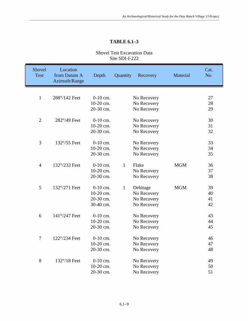
An Archaeological/Historical Study for the Otay Ranch Village 13 Project –––––––––––––––––––––––––––––––––––––––––––––––––––––––––––––––––––––––––––––––––––––––––––––––––––––––––––––––––––––
6.1–9
TABLE 6.1–3
Shovel Test Excavation Data Site SDI-I-222
Shovel Location Cat. Test from Datum A Depth Quantity Recovery Material No. Azimuth/Range 1 288°/142 Feet 0-10 cm. No Recovery 27 10-20 cm. No Recovery 28 20-30 cm. No Recovery 29 2 282°/49 Feet 0-10 cm. No Recovery 30 10-20 cm. No Recovery 31 20-30 cm. No Recovery 32 3 132°/55 Feet 0-10 cm. No Recovery 33 10-20 cm. No Recovery 34 20-30 cm. No Recovery 35 4 132°/233 Feet 0-10 cm. 1 Flake MGM 36 10-20 cm. No Recovery 37 20-30 cm. No Recovery 38 5 132°/271 Feet 0-10 cm. 1 Debitage MGM 39 10-20 cm. No Recovery 40 20-30 cm. No Recovery 41 30-40 cm. No Recovery 42 6 141°/247 Feet 0-10 cm. No Recovery 43 10-20 cm. No Recovery 44 20-30 cm. No Recovery 45 7 122°/234 Feet 0-10 cm. No Recovery 46 10-20 cm. No Recovery 47 20-30 cm. No Recovery 48 8 132°/18 Feet 0-10 cm. No Recovery 49 10-20 cm. No Recovery 50 20-30 cm. No Recovery 51

An Archaeological/Historical Study for the Otay Ranch Village 13 Project –––––––––––––––––––––––––––––––––––––––––––––––––––––––––––––––––––––––––––––––––––––––––––––––––––––––––––––––––––––
6.1–10
Shovel Location Cat. Test from Datum A Depth Quantity Recovery Material No. Azimuth/Range 9 132°/305 Feet 0-10 cm. No Recovery 52 10-20 cm. No Recovery 53 20-30 cm. No Recovery 54

An Archaeological/Historical Study for the Otay Ranch Village 13 Project –––––––––––––––––––––––––––––––––––––––––––––––––––––––––––––––––––––––––––––––––––––––––––––––––––––––––––––––––––––
6.1–11
TABLE 6.1–4
Summary of Artifact Recovery Site SDI-I-222
Recovery Category Surface Shovel Tests Total Percent Core Tools: Core Tool 1 - 1 4.35 Lithic Production Waste: Debitage 2 1 3 13.04 Flakes 13 1 14 60.87 Precision Tools: Retouched Flake 1 - 1 4.35 Utilized Debitage 3 - 3 13.04 Utilized Flake 1 - 1 4.35 Total 21 2 23 100.00 Percent 91.30 8.70 100.00 Rounded numbers may not add to 100%.

An Archaeological/Historical Study for the Otay Ranch Village 13 Project –––––––––––––––––––––––––––––––––––––––––––––––––––––––––––––––––––––––––––––––––––––––––––––––––––––––––––––––––––––
6.1–12
TABLE 6.1–5
Lithic Tool Measurement Data Site SDI-I-222
Cat. Tool Description Dimensions (in centimeters) Weight Material No. Length Width Thickness (in grams) Core Tools: 13 Core Tool 9.2 7.0 4.6 323.6 MGM Precision Tools: Retouched Flakes: 5 Retouched Flake 5.0 3.4 1.3 24.8 FGM Utilized Debitage: 12 Utilized Debitage 10.1 5.0 3.9 154.4 FGM 14 Utilized Debitage 6.0 4.5 4.1 118.2 MGM 22 Utilized Debitage Fragment 5.6 3.2 2.4 43.0 FGM Utilized Flakes: 17 Utilized Flake 8.2 4.4 1.7 55.5 MGM

An Archaeological/Historical Study for the Otay Ranch Village 13 Project –––––––––––––––––––––––––––––––––––––––––––––––––––––––––––––––––––––––––––––––––––––––––––––––––––––––––––––––––––––
6.2–1
6.2 Site SDI-11,388 6.2.1 Site Description This site consists of a dense lithic scatter located on a lower south-trending slope of a ridge system on the north side of Jamul Valley, immediately north of Otay Lakes Road, in the southeast corner of the project. The site was originally recorded by RECON in 1989 as a large prehistoric quarry and flake scatter. The overall configuration of the resource is shown in Figure 6.2–1. Elevations at the site range from 550 to 875 feet AMSL. A helicopter landing pad is located on the northern portion of the site and may have impacted that part of the site. Native vegetation of chamise chaparral is sparsely scattered across the site, although some areas have been brushed in the past. The setting of the site is shown in photographs provided in Plate 6.2–1. Site SDI-11,388 is located within the currently proposed construction zone and was therefore subjected to a testing and evaluation program by BFSA. Testing of the site consisted of the mapping and sampling of the surface scatter and the excavation of 42 shovel test pits and two test units. The field investigations were conducted on June 3 and October 17, 2002. 6.2.2 Previous Investigations The site was registered by RECON during a survey conducted in 1989 as a quarry area and flake scatter that measured approximately 400 by 240 meters (site form and Ritz et al. 1989). Artifacts observed on the surface of the site included over 160 pieces of metavolcanic lithic production waste, including cores, flakes and debitage. RECON identified no evidence of a subsurface deposit, although the site was not tested as part of that study. The site was mapped as occupying a large portion of the ridge. 6.2.3 Description of Field Investigations Field investigations conducted by BFSA at Site SDI-11,388 were executed using the standard methodologies described in Section 5.0. Lithic artifacts were recovered from surface and subsurface contexts of the site. Surface Recordation The entire surface of the site was inspected for evidence of prehistoric activity, resulting in the identification of a large number of surface artifacts. Two distinct loci were identified. A widely distributed scatter of artifacts was identified in the lower area mapped by RECON as part of the site (Datum A in Figure 6.2–1). In addition, a dense scatter of artifacts and quarry areas were relocated at the northern end of the mapped area of the site (Datums B and C in Figure 6.2–1). The characteristic of the site as a quarry was significantly understated by RECON, and the site was found to contain thousands of metavolcanic flakes and debitage on the upper slopes where good quality metavolcanic rock was exposed. Surface collections consisted of the collection of provenienced artifacts from surface contexts in areas of low artifact density, and, in

An Archaeological/Historical Study for the Otay Ranch Village 13 Project –––––––––––––––––––––––––––––––––––––––––––––––––––––––––––––––––––––––––––––––––––––––––––––––––––––––––––––––––––––
6.2–2
areas of high artifact density, collection of surface artifacts from seven separate one-by-one meter areas (surface scrapes), primarily in the northern portion of the site (Figure 6.2–1). A total of 594 artifacts were recovered from the surface of the site, including 466 artifacts from the seven surface scrape locations, and 128 artifacts from general surface locations. The recovery is summarized in Table 6.2–1, while detailed provenience information for the surface artifacts is presented in Table 6.2–2. Lithic production waste accounts for 97.81% (N=581) of the collection, while the remaining artifacts consisted of precision (1.69%; N=10), core (0.34%; N=2), and percussion (0.17%; N=1) tools. The distribution of the surface scrapes for the site indicates the highest density of the site is located along the property boundary. The area of the site, delineated by the artifact scatter, measures approximately 530 meters (1,740 feet) from southwest to northeast by 265 meters (870 feet) from northwest to southeast, and covers 62,281 square meters (670,145 square feet) (Figure 6.2–1). Subsurface Excavation The potential for subsurface archaeological deposits at Site SDI-11,388 was investigated by excavating a series of 42 STPs. The placement of the STPs, shown in Figure 6.2–1, was based on the distribution of the surface artifacts. The STPs were excavated to a minimum of 30 centimeters, or until bedrock was encountered. Five of the 42 STPs were positive for cultural material—three STPs (STPs 31, 33, and 34) near Datum E in the southern extent of the site and two STPs (STPs 38 and 41) near Datum B in the northern portion of the site. A total of 12 artifacts, all fine- and medium-grained metavolcanic flakes, were recovered from the STPs. Depth of recovery in the positive shovel tests was typically restricted to the 0 to 10 centimeter level, with the exception of STP 33, which had recovery at the 10 to 20 centimeter level. Provenience and depth information for the shovel tests is presented in Table 6.2–3. The testing program included the excavation of two test units at Site SDI-11,388. The test units were placed near areas of dense surface artifact recovery exhibiting evidence of quarrying (Figure 6.2–1). The test units were excavated in standard decimeter levels to 30 centimeters and all removed soils were sifted through 1/8-inch mesh hardware cloth. Excavations resulted in the recovery of 232 artifacts, and included one core, 79 pieces of debitage, 151 flakes, and one utilized flake (Tables 6.2–4 and 6.2–5). The maximum depth of recovery was 20 centimeters in Test Unit 1 and 30 centimeters in Test Unit 2 where bedrock was encountered. A total of 51 artifacts were recovered from Test Unit 1 in the northern portion of the site, while the remaining 181 artifacts were recovered from Test Unit 2 at the southern edge of the site.
The soil profile from Test Unit 1 was characterized as fine brown (7.5YR 5/4) cobbly loam underlain by metavolcanic rock. A drawing of the north wall of Test Unit 1 is presented in Figure 6.2–2. A color photograph of the north wall of Test Unit 1 is provided in Plate 6.2–1b. The soil profile from Test Unit 2 was characterized as a brown loam with organic matter to a

An Archaeological/Historical Study for the Otay Ranch Village 13 Project –––––––––––––––––––––––––––––––––––––––––––––––––––––––––––––––––––––––––––––––––––––––––––––––––––––––––––––––––––––
6.2–3
depth of approximately four centimeters, followed by a brown semi-compact silt to a depth of between 25 and 30 centimeters, followed by culturally sterile red clay. The excavation of the STPs and test unit determined that the site exhibits three localized subsurface deposits with no evidence of intervening subsurface deposits. The deposit in the southern part of the site near Datum E was delineated by three positive STPs and Test Unit 2; recovery in this area was sparse in the STPs but extensive in the unit, which was excavated in one of the few quarry areas in this portion of the site. This deposit measures approximately 59 meters (195 feet) by 48 meters (158 feet) and extended to a maximum depth of 30 centimeters. The deposit near Datum B was identified by two positive STPs, with cultural material identified to a maximum depth of 10 centimeters. This deposit measures approximately 31 meters (102 feet) by 15 meters (50 feet). Finally, the deposit identified near Datum C was identified by a positive test unit, in which cultural material extended to a maximum depth of 20 centimeters. This subsurface deposit measures approximately 18 meters (60 feet) by 18 meters (60 feet). Together, the three localized subsurface deposits cover 2,898 square meters (31,179 square feet).
6.2.4 Laboratory Analysis The laboratory analysis for Site SDI-11,388 included the standard procedures described in Section 5.0 of this report. All artifacts recovered from the field investigations conducted at the site were returned to the laboratory facility of BFSA to be cataloged and analyzed. A summary of artifacts recovered from the site is presented in Table 6.2–6. The recovery from Site SDI-11,388 included 838 lithic artifacts. Lithic Artifact Analysis Lithic production waste accounted for the largest category of lithic artifacts, representing 98.33% (N=824) of the lithic artifact collection and included 12 cores, 271 pieces of debitage or shatter, and 541 flakes. The remaining lithic collection from Site SDI-11,388 consisted of ten precision tools (1.32%), two core tools (0.24%), and one percussion tool (0.12%). Measurements of all lithic tools are presented in Table 6.2–7.
The precision tool category included one retouched piece of debitage, two retouched flakes, four scrapers, one piece of utilized debitage, and one utilized flake. The scrapers were identified as two flake scrapers, one domed scraper, and one core scraper (core scrapers are former core fragments with retouch and utilization around most of the artifact). The percussion tool from Site SDI-11,388 included one metavolcanic hammerstone. The core tools recovered from the site were cores that exhibited retouch on at least one edge. Activities indicated by the artifacts recovered from the site include procurement of lithic materials, lithic tool production and maintenance, as well as possible processing of plant and/or animal resources. All tools from the site were recovered from the surface of the site. Select tools recovered from the site are shown in Plate 6.2–3.

An Archaeological/Historical Study for the Otay Ranch Village 13 Project –––––––––––––––––––––––––––––––––––––––––––––––––––––––––––––––––––––––––––––––––––––––––––––––––––––––––––––––––––––
6.2–4
The material distribution of the lithic assemblage is uniform, as the collection consists entirely of locally available fine- and medium-grained metavolcanic material (Tables 6.2–2, 6.2–3, 6.2–5, and 6.2–7).
6.2.5 Discussion The testing demonstrated that Site SDI-11,388 consists of a large scatter of surface artifacts and a shallow, localized subsurface deposit. The overall site dimensions, identified by the surface scatter and positive subsurface excavation, measure 530 meters (1,740 feet) by 265 meters (870 feet), and cover 62,281 square meters (670,145 square feet). Subsurface excavations revealed three separate subsurface deposits across the site. Together, the three subsurface deposits cover 2,898 square meters (31,179 square feet). Based on the artifacts recovered, the site appears to represent a quarry area and temporary camp where lithic resource procurement, and lithic tool production and/or maintenance occurred.
Since none of the artifacts recovered from the site were culturally diagnostic, no cultural affiliation could be assigned to the resource. Given the localized nature of the subsurface deposit, and the fact that lithic production waste dominated recovery from subsurface contexts (99.57% of subsurface recovery), it is unlikely that further excavation would produce additional data that would allow such a determination. The site exhibits no ecofacts, features, or unique elements. Although several tool types were represented at the site, most of the collection is composed of lithic production waste. In addition, 70.88% (N=594) of the artifacts recovered were surface recovery. The testing of Site SDI-11,388, including the collection of a sample of surface artifacts, has exhausted the research potential of this site. According to the criteria listed in CEQA, Section 15064.5, and the guidelines set forth by the County of San Diego, the site is evaluated as having limited significance based upon the recovery of information that can contribute to the knowledge of prehistory in the region. However, the current program has exhausted the potential of the site to yield unique data and further study will not produce additional significant information. 6.2.6 Summary The investigation of Site SDI-11,388 did not produce any unique scientific data regarding site function or content. The identified artifacts indicate that site activities were focused primarily on procurement of lithic resources and lithic tool production and/or maintenance. The site represents one of several quarry sites in the area that correspond to good quality metavolcanic outcrops throughout the project area. Based on the information derived from the testing program, the site is characterized as possessing limited significance according to County of San Diego cultural resource guidelines. The site exhibits a large surface scatter of artifacts, a sample of which has been collected, a shallow localized subsurface deposit, and did not possess any intact features. The level of

An Archaeological/Historical Study for the Otay Ranch Village 13 Project –––––––––––––––––––––––––––––––––––––––––––––––––––––––––––––––––––––––––––––––––––––––––––––––––––––––––––––––––––––
6.2–5
information already obtained from this site has exhausted the research potential of this resource and it is unlikely that any significantly different information would be gathered from further investigation. No further archaeological investigations are recommended for Site SDI-11,388.

An Archaeological/Historical Study for the Otay Ranch Village 13 Project –––––––––––––––––––––––––––––––––––––––––––––––––––––––––––––––––––––––––––––––––––––––––––––––––––––––––––––––––––––
6.2–6
Figure 6.2–1 Excavation Location Map — Site SDI-11,388
(Deleted for Public Review; Bound Separately)

An Archaeological/Historical Study for the Otay Ranch Village 13 Project –––––––––––––––––––––––––––––––––––––––––––––––––––––––––––––––––––––––––––––––––––––––––––––––––––––––––––––––––––––
6.2–7
Plate 6.2–1
View of the north profile of Test Unit 1, 0 to 30 centimeters, at Site SDI-11,388. .
View of Site SDI-11,388 looking east (arrow identifies Datum A).


An Archaeological/Historical Study for the Otay Ranch Village 13 Project –––––––––––––––––––––––––––––––––––––––––––––––––––––––––––––––––––––––––––––––––––––––––––––––––––––––––––––––––––––
6.2–9
TABLE 6.2–1
Summary of Surface Recovery Site SDI-11,388
Artifact Category Surface Scrapes Total Percent Core Tools: Core Tools 1 1 2 0.34 Lithic Production Waste: Cores 2 9 11 1.85 Debitage 29 163 192 32.32 Flakes 89 289 378 63.64 Percussion Tools: Hammerstones - 1 1 0.17 Precision Tools: Retouched Debitage - 1 1 0.17 Retouched Flakes 2 - 2 0.34 Scrapers 3 1 4 0.67 Utilized Debitage 1 - 1 0.17 Utilized Flakes 1 1 2 0.34 Total 128 466 594 100.00 Percent 21.55 78.45 100.00 Rounded numbers may not add to 100%.

An Archaeological/Historical Study for the Otay Ranch Village 13 Project –––––––––––––––––––––––––––––––––––––––––––––––––––––––––––––––––––––––––––––––––––––––––––––––––––––––––––––––––––––
6.2–10
TABLE 6.2–2
Surface Scrape Recovery Data Site SDI-11,388
Recovery Location Quantity/ Cat. Location Datum from Datum Weight Recovery Material No. Azimuth/Range 1 D 105°/109 Feet 1 Domed Scraper MGM 130 1 Flake MGM 131 2 D 6°/775 Feet 1 Core Tool FGM 132 3 D 11°/745 Feet 1 Debitage FGM 133 4 D 19°/735 Feet 1 Flake FGM 134 1 Flake MGM 135 5 D 61°/672 Feet 1 Flake MGM 136 6 D 71°/85 Feet 1 Flake MGM 137 7 D 75°/83 Feet 1 Flake MGM 138 8 D 88°/106 Feet 1 Debitage FGM 139 9 D 112°/139 Feet 1 Flake MGM 140 10 D 123°/154 Feet 1 Flake MGM 141 11 D 129°/134 Feet 1 Debitage MGM 142 1 Flake MGM 143 12 D 136°/135 Feet 1 Flake MGM 144 13 D 145°/212 Feet 1 Flake FGM 145 1 Flake MGM 146 14 D 149°/217 Feet 1 Debitage MGM 147 15 E 179°/263 Feet 1 Flake FGM 148

An Archaeological/Historical Study for the Otay Ranch Village 13 Project –––––––––––––––––––––––––––––––––––––––––––––––––––––––––––––––––––––––––––––––––––––––––––––––––––––––––––––––––––––
6.2–11
Recovery Location Quantity/ Cat. Location Datum from Datum Weight Recovery Material No. Azimuth/Range 16 E 184°/239 Feet 3 Flakes FGM 149 17 E 194°/222 Feet 1 Flake FGM 150 18 E 202°/215 Feet 1 Flake MGM 151 19 E 197°/173 Feet 1 Core MGM 152 1 Debitage MGM 153 20 D 189°/346 Feet 1 Flake FGM 154 1 Debitage MGM 155 21 D 185°/362 Feet 1 Debitage FGM 156 22 D 182°/424 Feet 1 Flake FGM 157 23 D 182°/442 Feet 1 Flake Scraper FGM 158 24 D 182°/459 Feet 1 Flake MGM 159 25 D 186°/471 Feet 1 Utilized Debitage MGM 160 1 Flake FGM 161 26 D 189°/459 Feet 1 Debitage FGM 162 1 Flake FGM 163 27 D 190°/468 Feet 2 Flakes MGM 164 28 D 191°/457 Feet 1 Flake MGM 165 29 D 193°/152 Feet 1 Debitage MGM 166 1 Flake MGM 167 30 D 195°/458 Feet 1 Core MGM 168 31 D 196°/478 Feet 1 Debitage FGM 169 2 Flakes FGM 170 1 Debitage MGM 171
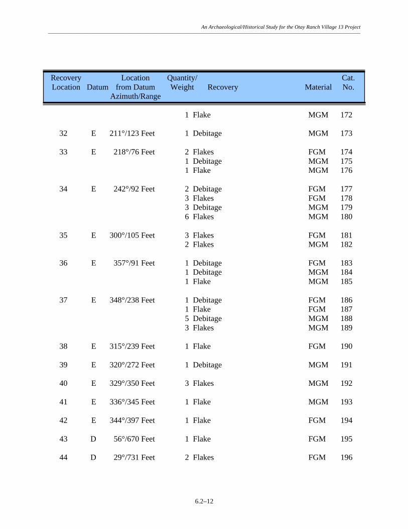
An Archaeological/Historical Study for the Otay Ranch Village 13 Project –––––––––––––––––––––––––––––––––––––––––––––––––––––––––––––––––––––––––––––––––––––––––––––––––––––––––––––––––––––
6.2–12
Recovery Location Quantity/ Cat. Location Datum from Datum Weight Recovery Material No. Azimuth/Range 1 Flake MGM 172 32 E 211°/123 Feet 1 Debitage MGM 173 33 E 218°/76 Feet 2 Flakes FGM 174 1 Debitage MGM 175 1 Flake MGM 176 34 E 242°/92 Feet 2 Debitage FGM 177 3 Flakes FGM 178 3 Debitage MGM 179 6 Flakes MGM 180 35 E 300°/105 Feet 3 Flakes FGM 181 2 Flakes MGM 182 36 E 357°/91 Feet 1 Debitage FGM 183 1 Debitage MGM 184 1 Flake MGM 185 37 E 348°/238 Feet 1 Debitage FGM 186 1 Flake FGM 187 5 Debitage MGM 188 3 Flakes MGM 189 38 E 315°/239 Feet 1 Flake FGM 190 39 E 320°/272 Feet 1 Debitage MGM 191 40 E 329°/350 Feet 3 Flakes MGM 192 41 E 336°/345 Feet 1 Flake MGM 193 42 E 344°/397 Feet 1 Flake FGM 194 43 D 56°/670 Feet 1 Flake FGM 195 44 D 29°/731 Feet 2 Flakes FGM 196

An Archaeological/Historical Study for the Otay Ranch Village 13 Project –––––––––––––––––––––––––––––––––––––––––––––––––––––––––––––––––––––––––––––––––––––––––––––––––––––––––––––––––––––
6.2–13
Recovery Location Quantity/ Cat. Location Datum from Datum Weight Recovery Material No. Azimuth/Range 45 D 26°/726 Feet 1 Flake FGM 197 46 D 354°/905 Feet 1 Debitage MGM 198 1 Flake MGM 199 47 F 0°/284 Feet 1 Flake FGM 200 3 Flakes MGM 201 48 F 344°/351 Feet 1 Flake MGM 202 49 D 354°/916 Feet 3 Flakes MGM 203 50 D 40°/799 Feet 1 Retouched Flake FGM 204 51 F 303°/42 Feet 1 Flake MGM 205 52 F 350°/108 Feet 1 Flake MGM 206 53 D 63°/758 Feet 2 Flakes MGM 207 54 D 65°/703 Feet 1 Utilized Flake FGM 208 1 Flake MGM 209 55 D 65°/423 Feet 1 Retouched Flake FGM 210 56 D 57°/315 Feet 1 Flake FGM 211 57 F 345°/394 Feet 1 Flake FGM 212 58 F 353°/511 Feet 1 Flake FGM 213 59 F 354°/615 Feet 2 Flakes FGM 214 1 Flake MGM 215 60 F 0°/722 Feet 1 Flake FGM 216 1 Flake MGM 217 61 D 9°/753 Feet 1 Flake FGM 218 1 Flake MGM 219

An Archaeological/Historical Study for the Otay Ranch Village 13 Project –––––––––––––––––––––––––––––––––––––––––––––––––––––––––––––––––––––––––––––––––––––––––––––––––––––––––––––––––––––
6.2–14
Recovery Location Quantity/ Cat. Location Datum from Datum Weight Recovery Material No. Azimuth/Range 62 D 14°/737 Feet 1 Flake FGM 220 63 D 43°/704 Feet 1 Debitage MGM 221 64 D 35°/707 Feet 1 Flake FGM 222 65 D 59°/775 Feet 1 Flake MGM 223 66 D 51°/585 Feet 1 Flake Scraper MGM 224 SS1 C 170°/153 Feet 1 Core Scraper FGM 1 1 Retouched Debitage FGM 2 6 Core Fragments FGM 3 19 Debitage FGM 4 20 Flakes FGM 5 Not an Artifact 6 14 Debitage MGM 7 19 Flakes MGM 8 SS2 C 164°/189 Feet 1 Core Tool Fragment FGM 9 1 Utilized Flake FGM 10 1 Hammerstone Fragment FGM 11 3 Cores FGM 12 15 Debitage FGM 13 28 Flakes FGM 14 8 Debitage MGM 15 SS2 C 164°/189 Feet 17 Flakes MGM 16 Not an Artifact 17 SS3 C 128°/81 Feet 2 Flakes FGM 18 SS4 C 165°/206 Feet 19 Debitage FGM 19 42 Flakes FGM 20 Not an Artifact 21 9 Debitage MGM 22 16 Flakes MGM 23 SS5 B 15°/28 Feet 1 Debitage MGM 24

An Archaeological/Historical Study for the Otay Ranch Village 13 Project –––––––––––––––––––––––––––––––––––––––––––––––––––––––––––––––––––––––––––––––––––––––––––––––––––––––––––––––––––––
6.2–15
Recovery Location Quantity/ Cat. Location Datum from Datum Weight Recovery Material No. Azimuth/Range SS6 E 178°/189 Feet 32 Debitage FGM 122 89 Flakes FGM 123 25 Debitage MGM 124 26 Flakes MGM 125 SS7 E 180°/155 Feet 12 Debitage FGM 126 23 Flakes FGM 127 9 Debitage MGM 128 7 Flakes MGM 129

An Archaeological/Historical Study for the Otay Ranch Village 13 Project –––––––––––––––––––––––––––––––––––––––––––––––––––––––––––––––––––––––––––––––––––––––––––––––––––––––––––––––––––––
6.2–16
TABLE 6.2–3
Shovel Test Excavation Data Site SDI-11,388
Shovel Location Cat. Test Datum from Datum Depth Quantity Recovery Material No. Azimuth/Range 1 A 0°/0 Feet 0-10 cm. No Recovery 25 10-20 cm. No Recovery 26 20-30 cm. No Recovery 27 2 A 0°/115 Feet 0-10 cm. No Recovery 28 10-20 cm. No Recovery 29 20-30 cm. No Recovery 30 3 A 0°/236 Feet 0-10 cm. No Recovery 31 10-20 cm. No Recovery 32 20-30 cm. No Recovery 33 4 A 270°/105 Feet 0-10 cm. No Recovery 34 10-20 cm. No Recovery 35 20-30 cm. No Recovery 36 5 A 200°/113 Feet 0-10 cm. No Recovery 37 10-20 cm. No Recovery 38 20-30 cm. No Recovery 39 6 A 200°/231 Feet 0-10 cm. No Recovery 40 10-20 cm. No Recovery 41 20-30 cm. No Recovery 42 7 A 200°/356 Feet 0-10 cm. No Recovery 43 10-20 cm. No Recovery 44 20-30 cm. No Recovery 45 8 A 90°/108 Feet 0-10 cm. No Recovery 46 10-20 cm. No Recovery 47 20-30 cm. No Recovery 48

An Archaeological/Historical Study for the Otay Ranch Village 13 Project –––––––––––––––––––––––––––––––––––––––––––––––––––––––––––––––––––––––––––––––––––––––––––––––––––––––––––––––––––––
6.2–17
Shovel Location Cat. Test Datum from Datum Depth Quantity Recovery Material No. Azimuth/Range 9 A 90°/260 Feet 0-10 cm. No Recovery 49 10-20 cm. No Recovery 50 20-30 cm. No Recovery 51 10 A 45°/115 Feet 0-10 cm. No Recovery 52 10-20 cm. No Recovery 53 20-30 cm. No Recovery 54 11 B 0°/0 Feet 0-10 cm. No Recovery 55 10-20 cm. No Recovery 56 20-30 cm. No Recovery 57 12 B 29°/80 Feet 0-10 cm. No Recovery 58 10-20 cm. No Recovery 59 20-30 cm. No Recovery 60 13 B 29°/172 Feet 0-10 cm. No Recovery 61 10-20 cm. No Recovery 62 20-30 cm. No Recovery 63 14 B 29°/293 Feet 0-10 cm. No Recovery 64 10-20 cm. No Recovery 65 20-30 cm. No Recovery 66 15 B 29°/390 Feet 0-10 cm. No Recovery 67 10-20 cm. No Recovery 68 20-30 cm. No Recovery 69 16 B 29°/480 Feet 0-10 cm. No Recovery 70 10-20 cm. No Recovery 71 20-30 cm. No Recovery 72 17 B 29°/558 Feet 0-10 cm. No Recovery 73 10-20 cm. No Recovery 74
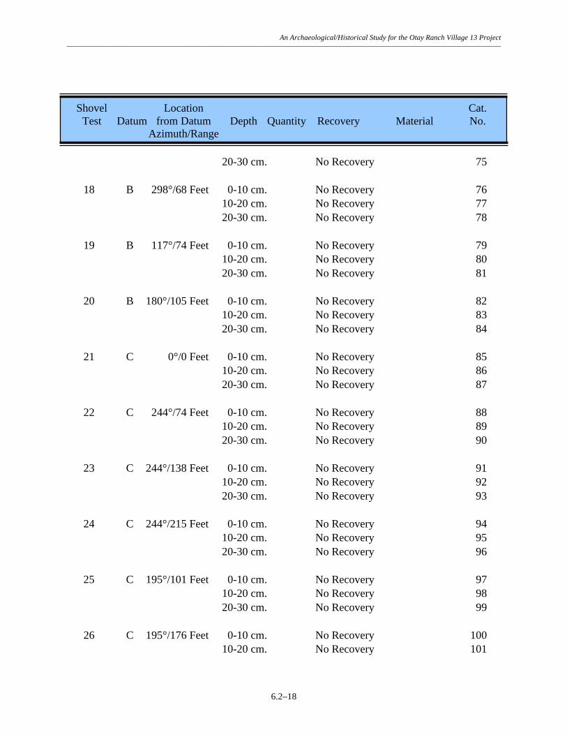
An Archaeological/Historical Study for the Otay Ranch Village 13 Project –––––––––––––––––––––––––––––––––––––––––––––––––––––––––––––––––––––––––––––––––––––––––––––––––––––––––––––––––––––
6.2–18
Shovel Location Cat. Test Datum from Datum Depth Quantity Recovery Material No. Azimuth/Range 20-30 cm. No Recovery 75 18 B 298°/68 Feet 0-10 cm. No Recovery 76 10-20 cm. No Recovery 77 20-30 cm. No Recovery 78 19 B 117°/74 Feet 0-10 cm. No Recovery 79 10-20 cm. No Recovery 80 20-30 cm. No Recovery 81 20 B 180°/105 Feet 0-10 cm. No Recovery 82 10-20 cm. No Recovery 83 20-30 cm. No Recovery 84 21 C 0°/0 Feet 0-10 cm. No Recovery 85 10-20 cm. No Recovery 86 20-30 cm. No Recovery 87 22 C 244°/74 Feet 0-10 cm. No Recovery 88 10-20 cm. No Recovery 89 20-30 cm. No Recovery 90 23 C 244°/138 Feet 0-10 cm. No Recovery 91 10-20 cm. No Recovery 92 20-30 cm. No Recovery 93 24 C 244°/215 Feet 0-10 cm. No Recovery 94 10-20 cm. No Recovery 95 20-30 cm. No Recovery 96 25 C 195°/101 Feet 0-10 cm. No Recovery 97 10-20 cm. No Recovery 98 20-30 cm. No Recovery 99 26 C 195°/176 Feet 0-10 cm. No Recovery 100 10-20 cm. No Recovery 101

An Archaeological/Historical Study for the Otay Ranch Village 13 Project –––––––––––––––––––––––––––––––––––––––––––––––––––––––––––––––––––––––––––––––––––––––––––––––––––––––––––––––––––––
6.2–19
Shovel Location Cat. Test Datum from Datum Depth Quantity Recovery Material No. Azimuth/Range 20-30 cm. No Recovery 102 27 C 84°/35 Feet 0-10 cm. No Recovery 103 10-20 cm. No Recovery 104 20-30 cm. No Recovery 105 28 C 5°/52 Feet 0-10 cm. No Recovery 106 10-20 cm. No Recovery 107 20-30 cm. No Recovery 108 29 C 325°/94 Feet 0-10 cm. No Recovery 109 10-20 cm. No Recovery 110 20-30 cm. No Recovery 111 30 C 274°/82 Feet 0-10 cm. No Recovery 112 10-20 cm. No Recovery 113 20-30 cm. No Recovery 114 31 E 183°/156 Feet 0-10 cm. 3 Flakes MGM 225 10-20 cm. No Recovery 226 20-30 cm. No Recovery 227 32 E 229°/155 Feet 0-10 cm. No Recovery 228 10-20 cm. No Recovery 229 20-30 cm. No Recovery 230 33 E 195°/217 Feet 0-10 cm. No Recovery 231 10-20 cm. 1 Flake FGM 232 4 Flakes MGM 233 20-30 cm. No Recovery 234 34 E 198°/250 Feet 0-10 cm. 1 Flake FGM 235 10-20 cm. No Recovery 236 20-30 cm. No Recovery 237 35 E 155°/171 Feet 0-10 cm. No Recovery 238

An Archaeological/Historical Study for the Otay Ranch Village 13 Project –––––––––––––––––––––––––––––––––––––––––––––––––––––––––––––––––––––––––––––––––––––––––––––––––––––––––––––––––––––
6.2–20
Shovel Location Cat. Test Datum from Datum Depth Quantity Recovery Material No. Azimuth/Range 10-20 cm. No Recovery 239 20-30 cm. No Recovery 240 36 D 3°/637 Feet 0-10 cm. No Recovery 241 10-20 cm. No Recovery 242 20-30 cm. No Recovery 243 37 D 3°/774 Feet 0-10 cm. No Recovery 244 10-20 cm. No Recovery 245 20-30 cm. No Recovery 246 38 D 4°/708 Feet 0-10 cm. 2 Flakes FGM 247 10-20 cm. No Recovery 248 20-30 cm. No Recovery 249 39 D 2°/716 Feet 0-10 cm. No Recovery 250 10-20 cm. No Recovery 251 20-30 cm. No Recovery 252 40 D 3°/728 Feet 0-10 cm. No Recovery 253 10-20 cm. No Recovery 254 20-30 cm. No Recovery 255 41 D 7°/723 Feet 0-10 cm. 1 Flake FGM 256 10-20 cm. No Recovery 257 20-30 cm. No Recovery 258 42 D 10°/724 Feet 0-10 cm. No Recovery 259 10-20 cm. No Recovery 260 20-30 cm. No Recovery 261

An Archaeological/Historical Study for the Otay Ranch Village 13 Project –––––––––––––––––––––––––––––––––––––––––––––––––––––––––––––––––––––––––––––––––––––––––––––––––––––––––––––––––––––
6.2–21
TABLE 6.2–4
Summary of Test Unit Recovery Site SDI-11,388
Depth (in centimeters) Artifact Category 0–10 10–20 20–30 Total Percent Lithic Production Waste: Core 1 - - 1 0.43 Debitage 56 15 8 79 34.05 Flakes 103 32 16 151 65.09 Precision Tools: Utilized Flake 1 - - 1 0.43 Total 161 47 24 232 100.00 Percent 69.40 20.26 10.34 100.00 Rounded numbers may not add to 100%.

An Archaeological/Historical Study for the Otay Ranch Village 13 Project –––––––––––––––––––––––––––––––––––––––––––––––––––––––––––––––––––––––––––––––––––––––––––––––––––––––––––––––––––––
6.2–22
TABLE 6.2–5
Test Unit Excavation Data Site SDI-11,388
Test Location Cat. Unit Datum from Datum Depth Quantity Recovery Material No. Azimuth/Range 1 C 171°/170 Feet 0-10 cm. 1 Core FGM 115 3 Debitage FGM 116 32 Flakes FGM 117 3 Debitage MGM 118 6 Flakes MGM 119 10-20 cm. 6 Flakes FGM 120 20-30 cm. No Recovery 121 2 E 180°/190 Feet 0-10 cm. 1 Utilized Flake Fragment FGM 262 27 Debitage FGM 263 36 Flakes FGM 264 23 Debitage MGM 265 29 Flakes MGM 266 10-20 cm. 7 Debitage FGM 267 7 Flakes FGM 268 8 Debitage MGM 269 19 Flakes MGM 270 20-30 cm. 2 Debitage FGM 271 6 Flakes FGM 272 6 Debitage MGM 273 10 Flakes MGM 274

An Archaeological/Historical Study for the Otay Ranch Village 13 Project –––––––––––––––––––––––––––––––––––––––––––––––––––––––––––––––––––––––––––––––––––––––––––––––––––––––––––––––––––––
6.2–23
TABLE 6.2–6
Summary of Artifact Recovery Site SDI-11388
Recovery Category Surface Shovel Tests Test Units Total Percent Core Tools: Core Tools 2 - - 2 0.24 Lithic Production Waste: Cores 11 - 1 12 1.43 Debitage 192 - 79 271 32.34 Flakes 378 12 151 541 64.56 Percussion Tools: Hammerstone 1 - - 1 0.12 Precision Tools: Retouched Debitage 1 - - 1 0.12 Retouched Flakes 2 - - 2 0.24 Scrapers 4 - - 4 0.48 Utilized Debitage 1 - - 1 0.12 Utilized Flakes 2 - 1 3 0.36 Total 594 12 232 838 100.00 Percent 70.88 1.43 27.68 100.00 Rounded numbers may not add to 100%.

An Archaeological/Historical Study for the Otay Ranch Village 13 Project –––––––––––––––––––––––––––––––––––––––––––––––––––––––––––––––––––––––––––––––––––––––––––––––––––––––––––––––––––––
6.2–24
TABLE 6.2–7
Lithic Tool Measurement Data Site SDI-11,388
Cat. Tool Description Dimensions (in centimeters) Weight Material No. Length Width Thickness (in grams) Core Tools:
9 Core Tool Fragment 10.5 5.6 4.5 384 FGM 132 Core Tool 9.7 8.5 4.8 328.5 FGM Percussion Tools: Hammerstones: 11 Hammerstone Fragment, 10.4 6.8 5.1 472.6 FGM Undetermined Precision Tools: Scrapers: 1 Core Scraper 11.0 10.2 3.5 277.5 FGM 130 Domed Scraper 9.6 8.5 5.9 417.6 MGM 158 Flake Scraper 5.4 5.1 1.1 38.9 FGM 224 Flake Scraper 9.4 9.2 3.3 412.2 MGM Retouched Debitage: 2 Retouched Debitage 7.3 5.3 2.3 102.0 FGM Retouched Flakes: 204 Retouched Flake 7.3 7.3 3.7 246.5 FGM 210 Retouched Flake 7.5 6.9 2.9 153.4 FGM Utilized Debitage: 160 Utilized Debitage 6.8 4.1 1.8 49.0 MGM Utilized Flakes: 10 Utilized Flake 13.6 7.3 3.5 289.7 FGM 208 Utilized Flake 4.0 2.5 0.4 5.3 FGM 262 Utilized Flake Fragment 5.1 4.1 0.9 22.3 FGM

An Archaeological/Historical Study for the Otay Ranch Village 13 Project –––––––––––––––––––––––––––––––––––––––––––––––––––––––––––––––––––––––––––––––––––––––––––––––––––––––––––––––––––––
6.3–1
6.3 Site SDI-11,389 6.3.1 Site Description This site consists of a sparse lithic scatter located on the lower southeastern slope of a terrace on the north side of Jamul Valley, in the southeast corner of the project. The site was originally recorded by RECON in 1989 as a flake scatter. The general configuration of the resource is shown in Figure 6.3–1. Elevations at the site range from 550 to 570 feet AMSL. Most of the native vegetation was previously cleared from the site. The clearing and subsequent erosion has impacted the site and resulted in the growth of moderately dense grasses. Native vegetation of chamise chaparral species is present directly northwest of the site. A graded dirt road extends along the southeastern edge of the site but does not appear to have impacted the site itself. The setting of the site is shown in a photograph provided in Plate 6.3–1a. Site SDI-11,389 is located within the currently proposed construction zone and was therefore subjected to a testing and evaluation program by BFSA. Testing of the site consisted of the mapping and recordation of all surface artifacts, and the excavation of ten shovel test pits and one test unit. The field investigations were conducted on June 25 and 26, 2002. 6.3.2 Previous Investigations The site was registered by RECON during a survey conducted in 1989 as a flake scatter that measured approximately 90 by 30 meters (site form and Ritz et al. 1989). Artifacts observed on the surface of the site included six fragments of lithic production waste. The site was not subjected to a testing phase during the RECON investigation. 6.3.3 Description of Field Investigations Field investigations conducted by BFSA at Site SDI-11,389 were executed using the standard methodologies described in Section 5.0. Lithic artifacts were recovered from the surface of the site; however, no subsurface deposits were identified. Surface Recordation The entire surface of the site was inspected for evidence of prehistoric activity, resulting in the identification of a limited number of surface artifacts. A total of 13 artifacts were recovered from the 11 surface locations that produced artifacts (laboratory analysis revealed that several of the specimens collected from surface locations were not cultural). The recovery is summarized in Table 6.3–1, while detailed provenience information for the surface artifacts is presented in Table 6.3–2. Lithic production waste accounts for 84.62% (N=11) of the collection, while the remaining artifacts (N=2) consisted of lithic production waste exhibiting minimal utilization. The area of the site, delineated by the artifact scatter, measures approximately 142 meters (467 feet) from southwest to northeast by 92 meters (303 feet) from northwest to southeast, and covers 6,949 square meters (74,775 square feet) (Figure 6.3–1).

An Archaeological/Historical Study for the Otay Ranch Village 13 Project –––––––––––––––––––––––––––––––––––––––––––––––––––––––––––––––––––––––––––––––––––––––––––––––––––––––––––––––––––––
6.3–2
Subsurface Excavation The potential for subsurface archaeological deposits at Site SDI-11,389 was investigated by excavating a series of 10 STPs. The placement of the STPs, shown in Figure 6.3–1, was based on the distribution of the surface artifacts. No artifacts were recovered from the STPs excavated at Site SDI-11,389. The STPs were excavated to a minimum of 30 centimeters, or until bedrock was encountered. Locational and depth information for the shovel tests is presented in Table 6.3–3. As originally proposed, the testing program included the excavation of a single test unit at Site SDI-11,389. Because all shovel tests were negative, the test unit was placed according to the surface artifact distribution (Figure 6.3–1). The test unit was excavated in standard decimeter levels to 30 centimeters and all removed soils were sifted through 1/8-inch mesh hardware cloth. No artifacts were recovered from the test unit excavation (Table 6.3–4). The soil profile from Test Unit 1 was characterized as compact grayish brown (10YR 5/2) cobbly loam to a depth of 20 centimeters, underlain by compact brown to dark brown (7.5YR 4/2) cobbly clay. A drawing of the north wall of Test Unit 1 is presented in Figure 6.3–2. A color photograph of the north wall of Test Unit 1 is provided in Plate 6.3–1b. The excavation of the STPs and test unit determined that no subsurface deposits are present at SDI-11,389.
6.3.4 Laboratory Analysis The laboratory analysis for Site SDI-11,389 included the standard procedures described in Section 5.0 of this report. All artifacts recovered from the field investigations conducted at the site were returned to the laboratory facility of BFSA to be cataloged and analyzed. The recovery from Site SDI-11,389 included 13 lithic artifacts. Lithic Artifact Analysis Lithic production waste accounted for the largest category of lithic artifacts, representing 84.62% (N=11) of the lithic artifact collection and included five pieces of debitage or shatter and six flakes. The remaining lithic collection from SDI-11,389 consisted of two pieces of utilized lithic production waste. Measurements for the two lithic tools are presented in Table 6.3–5. All artifacts collected from Site SDI-11,389 were derived from locally available fine- or medium-grained metavolcanics (Table 6.3–2). 6.3.5 Discussion The testing demonstrated that Site SDI-11,389 consists of a sparse scatter of lithic artifacts on the surface of the site; no subsurface cultural deposit was identified. The overall site dimensions, identified by the surface scatter, measure 142 meters (467 feet) by 92 meters (303 feet), and cover 6,949 square meters (74,775 square feet). The site appears to represent a

An Archaeological/Historical Study for the Otay Ranch Village 13 Project –––––––––––––––––––––––––––––––––––––––––––––––––––––––––––––––––––––––––––––––––––––––––––––––––––––––––––––––––––––
6.3–3
limited-use site where a limited amount of lithic tool production, and possible resource processing, occurred.
Since none of the artifacts recovered from the site were culturally diagnostic, no cultural affiliation could be assigned to the resource. Given the sparse nature of the surface scatter and the lack of a subsurface deposit, it is unlikely that further excavation would produce additional data that would allow such a determination. The site exhibits no ecofacts, features, or unique elements. The mapping and collection of surface artifacts have exhausted the research potential of this site. According to the criteria listed in CEQA, Section 15064.5, and the guidelines set forth by the County of San Diego , the site is evaluated as having limited significance based upon the recovery of information that can contribute to the knowledge of prehistory of the region. However, the current program has exhausted the potential of the site to yield unique data and further study will not produce additional significant information. 6.3.6 Summary The investigation of Site SDI-11,389 did not produce any unique scientific data regarding site function or content. The identified artifacts indicate that site activities were focused primarily on a limited amount of lithic tool production and possibly resource processing. The site represents one of several limited-use lithic manufacturing or maintenance sites in the area. Based on the information derived from the testing program, the site is characterized as possessing limited significance according to County of San Diego cultural resource guidelines. The site exhibits a sparse artifact scatter that has been collected, has no segregated special use areas or features, and did not possess any unique elements. The level of information already obtained from this site has exhausted the research potential of this resource and it is unlikely that any significantly different information would be gathered from further investigation. No further archaeological investigations are recommended for Site SDI-11,389.

An Archaeological/Historical Study for the Otay Ranch Village 13 Project –––––––––––––––––––––––––––––––––––––––––––––––––––––––––––––––––––––––––––––––––––––––––––––––––––––––––––––––––––––
6.3–4
Figure 6.3–1 Excavation Location Map — Site SDI-11,389
(Deleted for Public Review; Bound Separately)

An Archaeological/Historical Study for the Otay Ranch Village 13 Project –––––––––––––––––––––––––––––––––––––––––––––––––––––––––––––––––––––––––––––––––––––––––––––––––––––––––––––––––––––
6.3–5
Plate 6.3–1
View of the north profile of Test Unit 1, 0 to 30 centimeters, at Site SDI-11,389.
View of Site SDI-11,389 looking southwest (arrow identifies area of Datum A).


An Archaeological/Historical Study for the Otay Ranch Village 13 Project –––––––––––––––––––––––––––––––––––––––––––––––––––––––––––––––––––––––––––––––––––––––––––––––––––––––––––––––––––––
6.3–7
TABLE 6.3–1
Summary of Surface Recovery Site SDI-11,389
Recovery Category Quantity Percent Lithic Production Waste: Debitage 5 38.46 Flakes 6 46.15 Precision Tools: Utilized Debitage 1 7.69 Utilized Flake 1 7.69 Total 13 100.00 Rounded numbers may not add to 100%.

An Archaeological/Historical Study for the Otay Ranch Village 13 Project –––––––––––––––––––––––––––––––––––––––––––––––––––––––––––––––––––––––––––––––––––––––––––––––––––––––––––––––––––––
6.3–8
TABLE 6.3–2
Surface Recovery Data Site SDI-11,389
Recovery Location Quantity/ Cat. Location from Datum A Weight Recovery Material No. Azimuth/Range 1 96°/146 Feet 1 Flake FGM 1 2 60°/223 Feet 1 Utilized Flake FGM 2 3 24°/215 Feet Not an Artifact 3 4 20°/213 Feet 1 Debitage FGM 4 5 4°/235 Feet 1 Flake FGM 5 1 Flake MGM 6 6 0°/208 Feet 1 Debitage FGM 7 7 354°/170 Feet Not an Artifact 8 8 332°/143 Feet 1 Flake FGM 9 1 Debitage MGM 10 9 309°/84 Feet Not an Artifact 11 10 268°/83 Feet 1 Utilized Debitage Fragment MGM 12 11 242°/142 Feet Not an Artifact 13 12 241°/165 Feet Not an Artifact 14 13 265°/201 Feet 1 Debitage MGM 15 14 244°/238 Feet 1 Flake MGM 16 15 295°/103 Feet 1 Flake MGM 17 16 0°/230 Feet 1 Debitage FGM 18 17 109°/83 Feet Not an Artifact 19

An Archaeological/Historical Study for the Otay Ranch Village 13 Project –––––––––––––––––––––––––––––––––––––––––––––––––––––––––––––––––––––––––––––––––––––––––––––––––––––––––––––––––––––
6.3–9
TABLE 6.3–3
Shovel Test Excavation Data Site SDI-11,389
Shovel Location Cat. Test from Datum A Depth Recovery No. Azimuth/Range 1 0°/0 Feet 0-10 cm. No Recovery 20 10-20 cm. No Recovery 21 20-30 cm. No Recovery 22 2 0°/75 Feet 0-10 cm. No Recovery 23 10-20 cm. No Recovery 24 20-30 cm. No Recovery 25 3 0°/150 Feet 0-10 cm. No Recovery 26 10-20 cm. No Recovery 27 20-30 cm. No Recovery 28 4 0°/225 Feet 0-10 cm. No Recovery 29 10-20 cm. No Recovery 30 20-30 cm. No Recovery 31 5 90°/75 Feet 0-10 cm. No Recovery 32 10-20 cm. No Recovery 33 20-30 cm. No Recovery 34 6 90°/150 Feet 0-10 cm. No Recovery 35 10-20 cm. No Recovery 36 20-30 cm. No Recovery 37 7 180°/100 Feet 0-10 cm. No Recovery 38 10-20 cm. No Recovery 39 20-30 cm. No Recovery 40
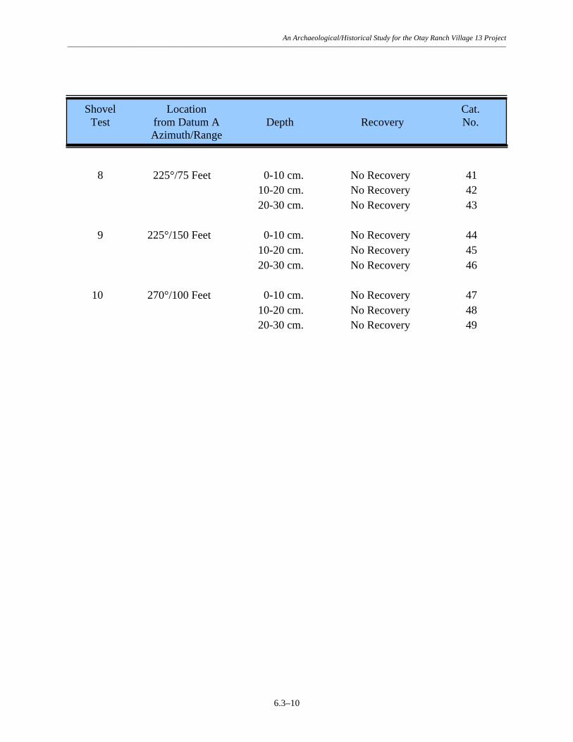
An Archaeological/Historical Study for the Otay Ranch Village 13 Project –––––––––––––––––––––––––––––––––––––––––––––––––––––––––––––––––––––––––––––––––––––––––––––––––––––––––––––––––––––
6.3–10
Shovel Location Cat. Test from Datum A Depth Recovery No. Azimuth/Range 8 225°/75 Feet 0-10 cm. No Recovery 41 10-20 cm. No Recovery 42 20-30 cm. No Recovery 43 9 225°/150 Feet 0-10 cm. No Recovery 44 10-20 cm. No Recovery 45 20-30 cm. No Recovery 46 10 270°/100 Feet 0-10 cm. No Recovery 47 10-20 cm. No Recovery 48 20-30 cm. No Recovery 49

An Archaeological/Historical Study for the Otay Ranch Village 13 Project –––––––––––––––––––––––––––––––––––––––––––––––––––––––––––––––––––––––––––––––––––––––––––––––––––––––––––––––––––––
6.3–11
TABLE 6.3–4
Test Unit Excavation Data Site SDI-11,389
Test Location Cat. Unit from Datum A Depth Recovery No. Azimuth/Range 1 212°/135 Feet 0-10 cm. No Recovery 50 10-20 cm. No Recovery 51 20-30 cm. No Recovery 52

An Archaeological/Historical Study for the Otay Ranch Village 13 Project –––––––––––––––––––––––––––––––––––––––––––––––––––––––––––––––––––––––––––––––––––––––––––––––––––––––––––––––––––––
6.3–12
TABLE 6.3–5
Lithic Tool Measurement Data Site SDI-11,389
Cat. Tool Description Dimensions (in centimeters) Weight Material No. Length Width Thickness (in grams) Precision Tools: Utilized Flakes: 2 Utilized Flake 4.0 3.5 0.7 14.8 FGM Utilized Debitage: 12 Utilized Debitage 6.9 2.8 1.8 31.5 MGM

An Archaeological/Historical Study for the Otay Ranch Village 13 Project –––––––––––––––––––––––––––––––––––––––––––––––––––––––––––––––––––––––––––––––––––––––––––––––––––––––––––––––––––––
6.4–1
6.4 Site SDI-11,391A 6.4.1 Site Description Site SDI-11,391A consists of a large lithic scatter located on the lower south facing slope immediately north of Otay Lakes Road, east of a seasonal drainage in the south central area of the project. The site was originally recorded by Ritz et al. (1989) as a lithic scatter and was relocated and tested by BFSA in June 2002. The general configuration of the resource is shown in Figure 6.4–1. Elevations at the site range from 540 to 650 feet AMSL. A dirt road runs through part of the site and has impacted a small area. Additionally, most of the site appears to have been brushed many years ago to improve grazing potential; however, native vegetation has made a significant return in the site area. The current vegetation consists mainly of native chamise chaparral with grasses and low shrubs. The setting of the Site SDI-11,391A is shown in photographs provided in Plate 6.4–1a. Site SDI-11,391A is located within the currently proposed construction zone and was therefore subjected to a testing and evaluation program by BFSA. Testing of the site consisted of the mapping and recordation of all surface artifacts, and the excavation of 40 shovel test pits and one test unit. The field investigations were conducted on July 15 and October 2, 2002. 6.4.2 Previous Investigations Site SDI-11,391A was registered by Ritz et al. during a survey conducted in 1989 as a medium density lithic scatter that measured approximately 700 by 850 meters. Artifacts observed on the surface of the site included over 300 fragments of metavolcanic lithic production waste, 10 cores, three core tools, and one metate scattered widely over a large area. The site was not subjected to a testing phase during the RECON investigation. 6.4.3 Description of Field Investigations Field investigations conducted by BFSA at Site SDI-11,391A were executed using the standard methodologies described in Section 5.0. A large number of lithic artifacts were recovered from the surface of the site and a shallow subsurface deposit was identified. Surface Recordation The entire surface of the site was inspected for evidence of prehistoric activity, resulting in the identification of both a dispersed scatter of surface artifacts and a single bedrock milling feature. The milling feature is a small, low-lying boulder. The feature, illustrated in Figure 6.4–2 and shown in Plate 6.4–1b, exhibits three surfaces including two slicks and one mortar start. The measurements for each of the individual surfaces are provided in Table 6.4–1.
In addition to the milling feature, a total of 1,423 artifacts were recovered from 432 surface locations were made from the surface of the site (laboratory analysis revealed that several of the specimens collected from surface locations were not cultural). Figure 6.4–1 illustrates the

An Archaeological/Historical Study for the Otay Ranch Village 13 Project –––––––––––––––––––––––––––––––––––––––––––––––––––––––––––––––––––––––––––––––––––––––––––––––––––––––––––––––––––––
6.4–2
locations of these surface collections and clearly identified the boundaries of the site. The recovery is summarized in Table 6.4–2, while detailed provenience information for the surface artifacts is presented in Table 6.4–3. Lithic production waste accounts for 84.12% (N=1,197) of the collection, while the remaining artifacts consisted of precision (11.38%; N=162), percussion (1.90%; N=27), and multi-use (0.70%; N=10) tools. In addition, a small amount of FAR was recovered from the surface of the site. The surface artifacts are widely scattered around the upper edge of the entire landform with a slight concentration at its southeast edge (Figure 6.4–1). The area of the site delineated by the artifact scatter measures approximately 593 meters (1,945 feet) from southwest to northeast by 476 meters (1,562 feet) from northwest to southeast, and covers 138,218 square meters (1,487,233 square feet) (Figure 6.4–1). Subsurface Excavation The potential for subsurface archaeological deposits at Site SDI-11,391A was investigated by excavating a series of 40 STPs. The placement of the STPs, shown in Figure 6.4–1, was based on the distribution of the surface artifacts. The STPs were excavated to a minimum of 30 centimeters, or until bedrock was encountered. The recovery is summarized in Table 6.4–4, while provenience and depth information for the shovel tests is presented in Table 6.4–5. A total of eight artifacts were recovered from the STPs excavated at Site SDI-11,391A, including seven flakes and one utilized flake. Recovery was limited to two shovel tests; seven from STP 22 and one from STP 35. Recovery from these shovel tests was restricted to the 0 to 10 centimeter level. The testing program included the excavation of a single test unit at Site SDI-11,391A. Because of the paucity of recovery and shallow depth of recovery in shovel tests, the test unit was placed in an area of relatively high surface artifact concentration (Figure 6.4–1). The test unit was excavated in standard decimeter levels to 30 centimeters and all removed soils were sifted through 1/8-inch mesh hardware cloth. No artifacts were recovered from the test unit excavation (Table 6.4–6). The soil profile from Test Unit 1 was characterized as compact dark brown to brown (7.5YR 4/4) gravely loam with cobbles. A drawing of the north wall of Test Unit 1 is presented in Figure 6.4–3. A color photograph of the north wall of Test Unit 1 is provided in Plate 6.4–2. The excavation of the STPs and test unit determined that the subsurface deposit at SDI-11,391A is shallow and contains a sparse scatter of artifacts. It is located in the center of the site, at the southeast edge of the landform (Figure 6.4–1). The deposit measures approximately 79 meters (260 feet) from northwest to southeast by 28 meters (92 feet) from southwest to northeast, and covers 2,254 square meters (24,251 square feet) (Figure 6.4–1).

An Archaeological/Historical Study for the Otay Ranch Village 13 Project –––––––––––––––––––––––––––––––––––––––––––––––––––––––––––––––––––––––––––––––––––––––––––––––––––––––––––––––––––––
6.4–3
6.4.4 Discussion The testing demonstrated that Site SDI-11,391A consists of a large scatter of lithic artifacts on the surface of the site; a shallow, sparse subsurface cultural deposit was also identified. The overall site dimensions, identified by the surface scatter, measure approximately 593 meters (1,945 feet) by 476 meters (1,562 feet), and cover 138,218 square meters (1,487,233 square feet). Excavations revealed that the subsurface deposit at the site measures approximately 79 meters (260 feet) by 28 meters (92 feet), and covers 2,254 square meters (24,251 square feet). The artifacts recovered from Site SDI-11,391A, most of which include surface collections that are currently being analyzed, consisted primarily of lithic production waste. In addition to the artifact recovery, a small amount of fire-affected rock was recovered from the surface of the site. Subsurface excavations resulted in the recovery of eight artifacts, including seven pieces of lithic production waste and one utilized flake (Table 6.4–7). The dimensions of the lithic tool are provided in Table 6.4–8. As at the other Village 13 sites, most of the artifacts collected from Site SDI-11,391A were derived from locally available fine- or medium-grained metavolcanic material (Tables 6.4–3, in progress, and Table 6.4–5). No culturally diagnostic artifacts were recovered from the site in either surface or subsurface contexts. The site appears to represent a limited-use site where a limited amount of lithic tool production, and possible resource processing, occurred.
Since none of the artifacts recovered from the site were culturally diagnostic, no cultural affiliation could be assigned to the resource. Given the fact that the site consists primarily of a surface artifact scatter that has been completely collected, it is unlikely that further excavation would produce additional data that would allow such a determination. The site exhibits no ecofacts, features, or unique elements. The only FAR recovered from the site was from the surface, indicating that any burned rock features that may have existed are probably deflated and scattered, and therefore lack integrity. The mapping and collection of surface artifacts have exhausted the research potential of this site. According to the criteria listed in CEQA, Section 15064.5, and the guidelines set forth by the County of San Diego , the site is evaluated as having limited significance based upon the recovery of information that can contribute to the knowledge of prehistory in the region. However, the current program has exhausted the potential of the site to yield unique data, and further study will not produce additional significant information. 6.4.5 Summary The investigation of Site SDI-11,391A did not produce any unique scientific data regarding site function or content. The identified artifacts indicate that site activities were focused primarily on a limited amount of lithic tool production and possibly resource processing. The site represents one of several limited-use lithic manufacturing or maintenance sites in the area.

An Archaeological/Historical Study for the Otay Ranch Village 13 Project –––––––––––––––––––––––––––––––––––––––––––––––––––––––––––––––––––––––––––––––––––––––––––––––––––––––––––––––––––––
6.4–4
Based on the information derived from the testing program, the site is characterized as possessing limited significance according to County of San Diego cultural resource guidelines. The site exhibits a widely distributed surface artifact scatter that has been collected, a shallow subsurface deposit containing a paucity of artifacts, and did not possess any segregated special use areas, features or unique elements. The level of information already obtained from this site has exhausted the research potential of this resource, and it is unlikely that any significantly different information would be gathered from further investigation. No further archaeological investigations are recommended for Site SDI-11,391A.

An Archaeological/Historical Study for the Otay Ranch Village 13 Project –––––––––––––––––––––––––––––––––––––––––––––––––––––––––––––––––––––––––––––––––––––––––––––––––––––––––––––––––––––
6.4–5
Figure 6.4–1 Excavation Location Map — Site SDI-11,391A
(Deleted for Public Review; Bound Separately)

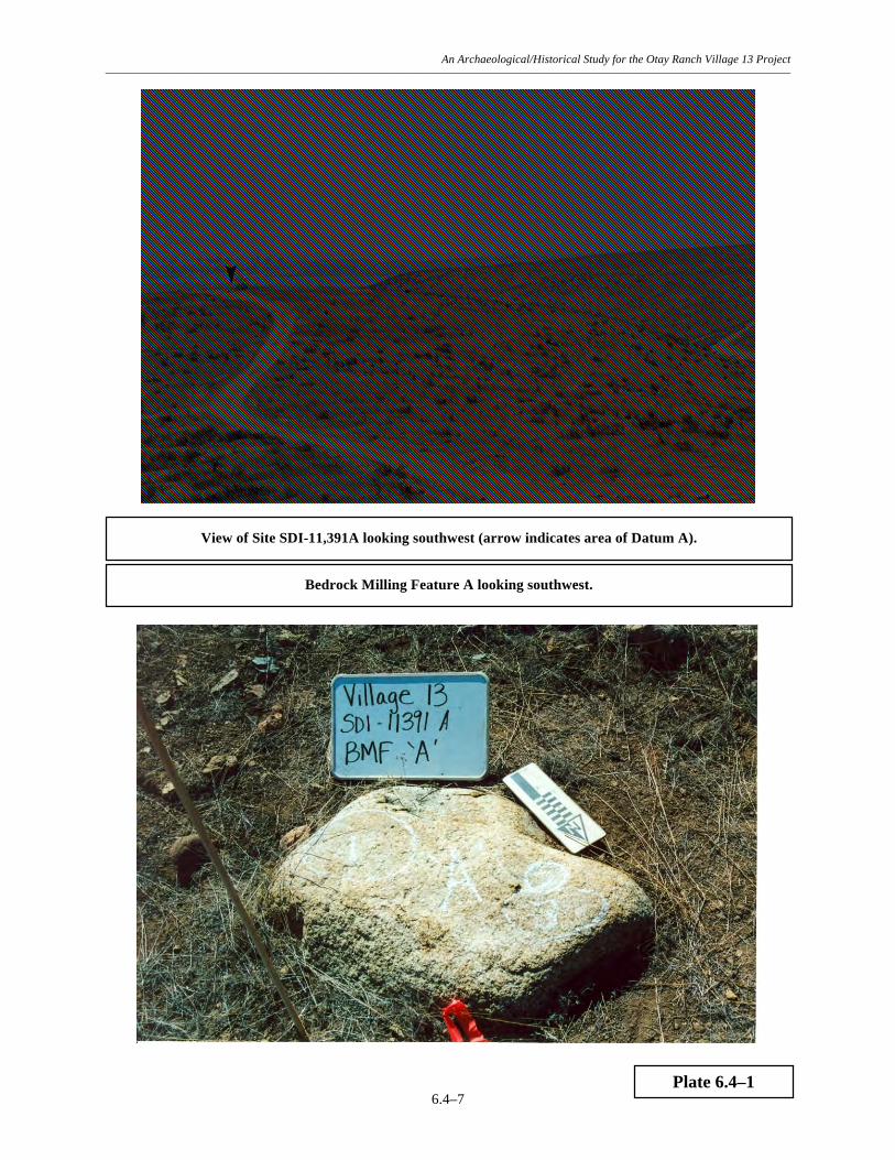
An Archaeological/Historical Study for the Otay Ranch Village 13 Project –––––––––––––––––––––––––––––––––––––––––––––––––––––––––––––––––––––––––––––––––––––––––––––––––––––––––––––––––––––
6.4–7
Plate 6.4–1
Bedrock Milling Feature A looking southwest.
View of Site SDI-11,391A looking southwest (arrow indicates area of Datum A).


An Archaeological/Historical Study for the Otay Ranch Village 13 Project –––––––––––––––––––––––––––––––––––––––––––––––––––––––––––––––––––––––––––––––––––––––––––––––––––––––––––––––––––––
6.4–10
TABLE 6.4–1
Bedrock Milling Feature Data Site SDI-11,391A
Location Feature from Datum B Surface Type Dimensions Azimuth/Range L x W x D A 132°/121 Feet 1 Slick 26.0 x 21.0 x 0.1 cm. 2 Mortar Start 9.0 x 8.0 x 3.0 cm. 3 Slick 21.0 x 12.0 x 0.1 cm.

An Archaeological/Historical Study for the Otay Ranch Village 13 Project –––––––––––––––––––––––––––––––––––––––––––––––––––––––––––––––––––––––––––––––––––––––––––––––––––––––––––––––––––––
6.4–11
TABLE 6.4–2
Summary of Surface Recovery Site SDI-11,391A
Recovery Category Quantity Percent
Core Tools: Core Tools 27 1.90
Lithic Production Waste:
Cores 14 0.98 Debitage 212 14.90
Flakes 971 68.24
Percussion Tools: Hammerstones 27 1.90
Precision Tools:
Retouched Debitage 6 0.42 Retouched Flakes 11 0.77
Scrapers 6 0.42 Utilized Debitage 61 4.29
Utilized Flakes 78 5.48
Multi-Use Tools: Chopper/Hammerstones 3 0.21
Hammer/Cores 7 0.49
Miscellaneous: FAR, FGM 121.8 g.
Total 1,423 100.00

An Archaeological/Historical Study for the Otay Ranch Village 13 Project –––––––––––––––––––––––––––––––––––––––––––––––––––––––––––––––––––––––––––––––––––––––––––––––––––––––––––––––––––––
6.4–12
TABLE 6.4–3
Surface Recovery Data Site SDI-11,391A
(Placed in Appendix III)

An Archaeological/Historical Study for the Otay Ranch Village 13 Project –––––––––––––––––––––––––––––––––––––––––––––––––––––––––––––––––––––––––––––––––––––––––––––––––––––––––––––––––––––
6.4–13
TABLE 6.4–4
Summary of Shovel Test Recovery Site SDI-11,391A
Recovery Category Quantity Percent Lithic Production Waste: Flakes 7 87.50 Precision Tools: Utilized Flake 1 12.50 Total 8 100.00 Rounded numbers may not add to 100%.
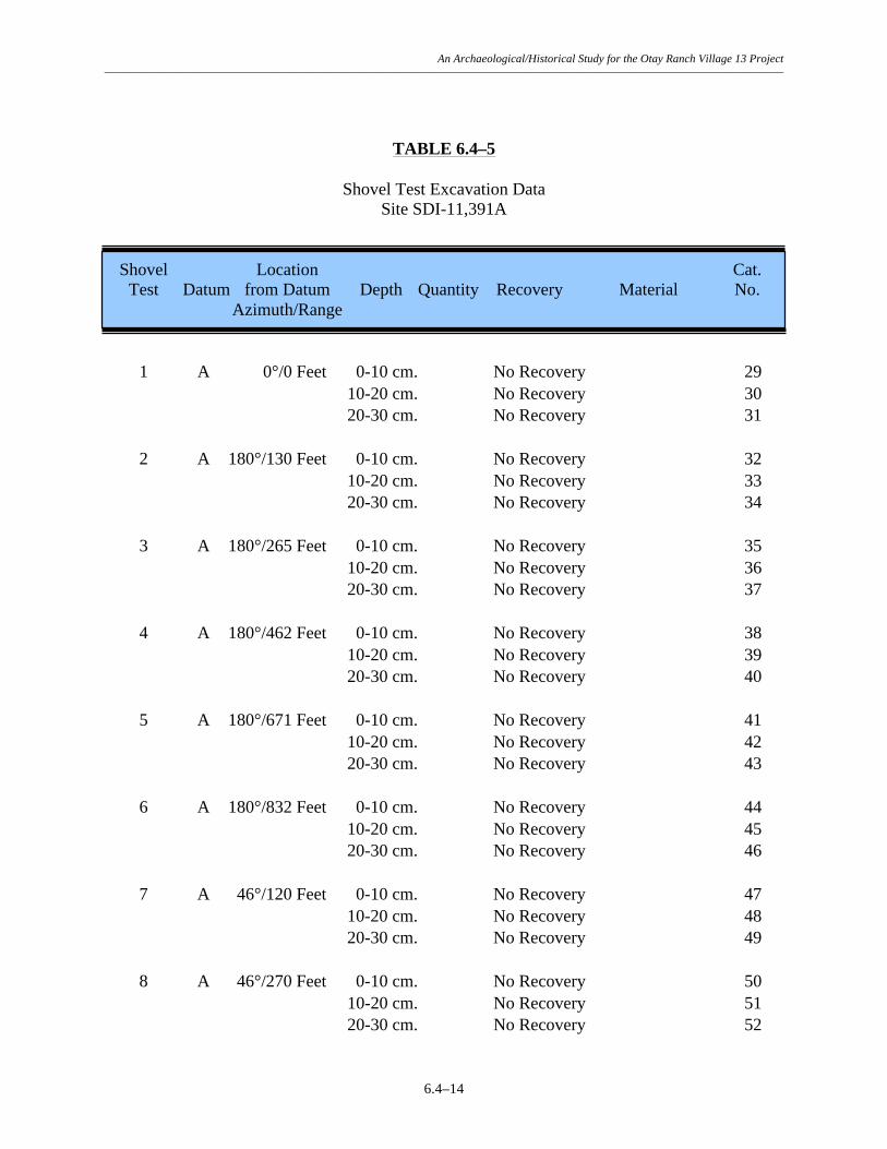
An Archaeological/Historical Study for the Otay Ranch Village 13 Project –––––––––––––––––––––––––––––––––––––––––––––––––––––––––––––––––––––––––––––––––––––––––––––––––––––––––––––––––––––
6.4–14
TABLE 6.4–5
Shovel Test Excavation Data Site SDI-11,391A
Shovel Location Cat. Test Datum from Datum Depth Quantity Recovery Material No. Azimuth/Range 1 A 0°/0 Feet 0-10 cm. No Recovery 29 10-20 cm. No Recovery 30 20-30 cm. No Recovery 31 2 A 180°/130 Feet 0-10 cm. No Recovery 32 10-20 cm. No Recovery 33 20-30 cm. No Recovery 34 3 A 180°/265 Feet 0-10 cm. No Recovery 35 10-20 cm. No Recovery 36 20-30 cm. No Recovery 37 4 A 180°/462 Feet 0-10 cm. No Recovery 38 10-20 cm. No Recovery 39 20-30 cm. No Recovery 40 5 A 180°/671 Feet 0-10 cm. No Recovery 41 10-20 cm. No Recovery 42 20-30 cm. No Recovery 43 6 A 180°/832 Feet 0-10 cm. No Recovery 44 10-20 cm. No Recovery 45 20-30 cm. No Recovery 46 7 A 46°/120 Feet 0-10 cm. No Recovery 47 10-20 cm. No Recovery 48 20-30 cm. No Recovery 49 8 A 46°/270 Feet 0-10 cm. No Recovery 50 10-20 cm. No Recovery 51 20-30 cm. No Recovery 52

An Archaeological/Historical Study for the Otay Ranch Village 13 Project –––––––––––––––––––––––––––––––––––––––––––––––––––––––––––––––––––––––––––––––––––––––––––––––––––––––––––––––––––––
6.4–15
Shovel Location Cat. Test Datum from Datum Depth Quantity Recovery Material No. Azimuth/Range 9 A 125°/112 Feet 0-10 cm. No Recovery 53 10-20 cm. No Recovery 54 20-30 cm. No Recovery 55 10 A 125°/305 Feet 0-10 cm. No Recovery 56 10-20 cm. No Recovery 57 20-30 cm. No Recovery 58 11 A 125°/419 Feet 0-10 cm. No Recovery 59 10-20 cm. No Recovery 60 20-30 cm. No Recovery 61 12 A 156°/322 Feet 0-10 cm. No Recovery 62 10-20 cm. No Recovery 63 20-30 cm. No Recovery 64 13 A 162°/428 Feet 0-10 cm. No Recovery 65 10-20 cm. No Recovery 66 20-30 cm. No Recovery 67 14 A 169°/446 Feet 0-10 cm. No Recovery 68 10-20 cm. No Recovery 69 20-30 cm. No Recovery 70 15 A 205°/276 Feet 0-10 cm. No Recovery 71 10-20 cm. No Recovery 72 20-30 cm. No Recovery 73 16 A 190°/802 Feet 0-10 cm. No Recovery 74 10-20 cm. No Recovery 75 20-30 cm. No Recovery 76 17 A 194°/931 Feet 0-10 cm. No Recovery 77 10-20 cm. No Recovery 78

An Archaeological/Historical Study for the Otay Ranch Village 13 Project –––––––––––––––––––––––––––––––––––––––––––––––––––––––––––––––––––––––––––––––––––––––––––––––––––––––––––––––––––––
6.4–16
Shovel Location Cat. Test Datum from Datum Depth Quantity Recovery Material No. Azimuth/Range 20-30 cm. No Recovery 79 18 A 161°/608 Feet 0-10 cm. No Recovery 80 10-20 cm. No Recovery 81 20-30 cm. No Recovery 82 19 A 0°/128 Feet 0-10 cm. No Recovery 83 10-20 cm. No Recovery 84 20-30 cm. No Recovery 85 20 A 270°/171 Feet 0-10 cm. No Recovery 86 10-20 cm. No Recovery 87 20-30 cm. No Recovery 88 21 A 153°/527 Feet 0-10 cm. No Recovery 92 10-20 cm. No Recovery 93 20-30 cm. No Recovery 94 22 A 164°/576 Feet 0-10 cm. 1 Utilized Flake FGM 95 6 Flakes FGM 96 10-20 cm. No Recovery 97 20-30 cm. No Recovery 98 23 B 192°/291 Feet 0-10 cm. No Recovery 99 10-20 cm. No Recovery 100 20-30 cm. No Recovery 101 24 C 111°/46 Feet 0-10 cm. No Recovery 102 10-20 cm. No Recovery 103 20-30 cm. No Recovery 104 25 C 151°/110 Feet 0-10 cm. No Recovery 105 10-20 cm. No Recovery 106 20-30 cm. No Recovery 107 26 B 158°/617 Feet 0-10 cm. No Recovery 108

An Archaeological/Historical Study for the Otay Ranch Village 13 Project –––––––––––––––––––––––––––––––––––––––––––––––––––––––––––––––––––––––––––––––––––––––––––––––––––––––––––––––––––––
6.4–17
Shovel Location Cat. Test Datum from Datum Depth Quantity Recovery Material No. Azimuth/Range 10-20 cm. No Recovery 109 20-30 cm. No Recovery 110 27 C 200°/196 Feet 0-10 cm. No Recovery 111 10-20 cm. No Recovery 112 20-30 cm. No Recovery 113 28 C 221°/357 Feet 0-10 cm. No Recovery 114 10-20 cm. No Recovery 115 20-30 cm. No Recovery 116 29 D 154°/180 Feet 0-10 cm. No Recovery 117 10-20 cm. No Recovery 118 20-30 cm. No Recovery 119 30 D 252°/79 Feet 0-10 cm. No Recovery 120 10-20 cm. No Recovery 121 20-30 cm. No Recovery 122 31 A 203°/910 Feet 0-10 cm. No Recovery 123 10-20 cm. No Recovery 124 20-30 cm. No Recovery 125 32 A 209°/781 Feet 0-10 cm. No Recovery 126 10-20 cm. No Recovery 127 20-30 cm. No Recovery 128 33 A 211°/487 Feet 0-10 cm. No Recovery 129 10-20 cm. No Recovery 130 20-30 cm. No Recovery 131 34 E 9°/434 Feet 0-10 cm. No Recovery 132 10-20 cm. No Recovery 133 20-30 cm. No Recovery 134 35 E 5°/762 Feet 0-10 cm. 1 Flake FGM 135

An Archaeological/Historical Study for the Otay Ranch Village 13 Project –––––––––––––––––––––––––––––––––––––––––––––––––––––––––––––––––––––––––––––––––––––––––––––––––––––––––––––––––––––
6.4–18
Shovel Location Cat. Test Datum from Datum Depth Quantity Recovery Material No. Azimuth/Range 10-20 cm. No Recovery 136 20-30 cm. No Recovery 137 36 E 2°/227 Feet 0-10 cm. No Recovery 138 10-20 cm. No Recovery 139 20-30 cm. No Recovery 140 37 E 357°/765 Feet 0-10 cm. No Recovery 141 10-20 cm. No Recovery 142 20-30 cm. No Recovery 143 38 B 163°/114 Feet 0-10 cm. No Recovery 144 10-20 cm. No Recovery 145 20-30 cm. No Recovery 146 39 B 22°/271 Feet 0-10 cm. No Recovery 147 10-20 cm. No Recovery 148 20-30 cm. No Recovery 149 40 B 15°/472 Feet 0-10 cm. No Recovery 150 10-20 cm. No Recovery 151 20-30 cm. No Recovery 152

An Archaeological/Historical Study for the Otay Ranch Village 13 Project –––––––––––––––––––––––––––––––––––––––––––––––––––––––––––––––––––––––––––––––––––––––––––––––––––––––––––––––––––––
6.4–19
TABLE 6.4–6
Test Unit Excavation Data Site SDI-11,391A
Test Location Cat. Unit from Datum A Depth Recovery No. Azimuth/Range 1 181°/460 Feet 0-10 cm. No Recovery 89 10-20 cm. No Recovery 90 20-30 cm. No Recovery 91

An Archaeological/Historical Study for the Otay Ranch Village 13 Project –––––––––––––––––––––––––––––––––––––––––––––––––––––––––––––––––––––––––––––––––––––––––––––––––––––––––––––––––––––
6.4–20
TABLE 6.4–7
Summary of Artifact Recovery Site SDI-11,391A
Recovery Category Surface Shovel Tests Test Units Total Percent Core Tools: Core Tools 27 - - 27 1.89 Lithic Production Waste: Cores 14 - - 14 0.98 Debitage 212 - - 212 14.81 Flakes 971 7 - 978 68.34 Percussion Tools: Hammerstones 27 1 - 27 1.89 Precision Tools: Retouched Debitage 6 - - 6 0.42 Retouched Flakes 11 - - 11 0.77 Scrapers 6 - - 6 0.42 Utilized Debitage 61 - - 61 4.26 Utilized Flakes 78 1 - 79 5.52 Multi-Use Tools: Chopper/Hammerstones 3 - - 3 0.21 Hammer/Cores 7 - 7 0.49 Total 9 0 1,431 100.00 Percent 0.63 0.00 100.00 Rounded numbers may not add to 100%.
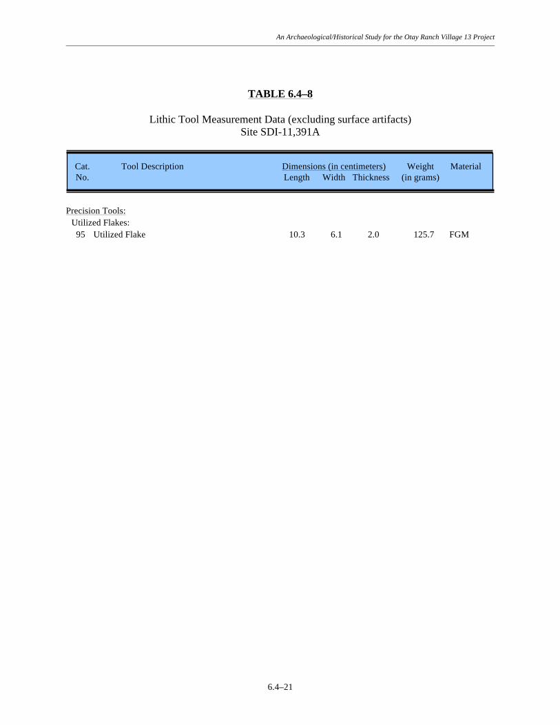
An Archaeological/Historical Study for the Otay Ranch Village 13 Project –––––––––––––––––––––––––––––––––––––––––––––––––––––––––––––––––––––––––––––––––––––––––––––––––––––––––––––––––––––
6.4–21
TABLE 6.4–8
Lithic Tool Measurement Data (excluding surface artifacts) Site SDI-11,391A
Cat. Tool Description Dimensions (in centimeters) Weight Material No. Length Width Thickness (in grams) Precision Tools: Utilized Flakes: 95 Utilized Flake 10.3 6.1 2.0 125.7 FGM