ordinance no. file no. tec9-4 an ordinance of the...
TRANSCRIPT

ORDINANCE NO . 3585File No. TEC9-4
AN ORDINANCE OF THE CITY OF MESQUITE, TEXAS ,AMENDING THE MESQUITE ZONING ORDINANC EADOPTED ON SEPTEMBER 4, 1973, AND RECODIFIED O NNOVEMBER 21, 1988, SO AS TO APPROVE ACONDITIONAL USE PERMIT ON PROPERTY ZONEDCOMMERICAL THEREBY ALLOWING OUTDOOR SALE SAND DISPLAY FOR A MOTORCYCLE DEALERSHIP;REPEALING ALL ORDINANCES IN CONFLICT WITH TH EPROVISIONS OF THIS ORDINANCE; PROVIDING FOR ASEVERABILITY CLAUSE; PROVIDING FOR A PENALT YNOT TO EXCEED TWO THOUSAND DOLLARS ($2,000 .00)FOR EACH OFFENSE; AND DECLARING AN EMERGENCY .
WHEREAS, the Planning and Zoning Commission of the City of Mesquite and thegoverning body of the City of Mesquite, in compliance with the Charter of the City of Mesquiteand State laws with reference to granting of zoning changes under the Zoning Ordinanc eRegulations and Zoning Map, have given the requisite notices by publication and otherwise, an dafter holding due hearings and affording a full and fair hearing to all property owners generall yand to the persons interested and situated in the area, the City of Mesquite is of the opinion tha tthe change of zoning may be granted herein.
NOW, THEREFORE, BE IT ORDAINED BY THE CITY COUNCIL OF THE CIT YOF MESQUITE, TEXAS :
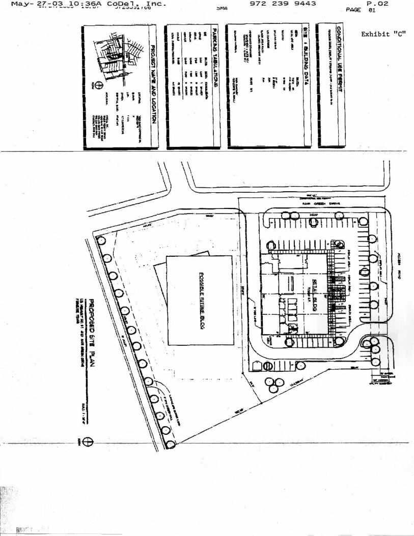
SECTION 1 . That the Mesquite Zoning Ordinance adopted on September 4 ,1973, and recodified on November 21, 1988, be and the same is hereby amended by amendin gthe Zoning Map of the City of Mesquite so as to approve a Conditional Use Permit on propert yzoned Commercial thereby allowing outdoor sales and display for a motorcycle dealershi plocated at the northeast corner of Fair Green Drive and the U . S. Highway 67 Frontage Road andsubject to the concept plan in Exhibit "C" attached hereto .
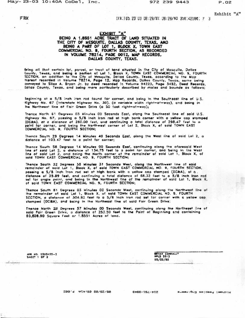
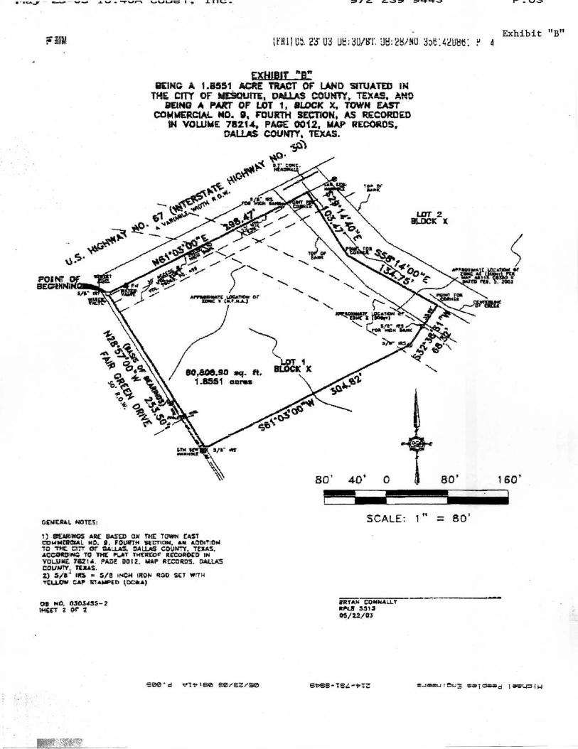
That the subject property is described as a 1 .78-acre tract, bein gpart of Lot 1, Block X, of the Town East Commercial No . 9 Addition and is more fully describe din the approved field notes in Exhibits "A" and "B" attached hereto .
SECTION 2. That all ordinances, or portions thereof, of the City of Mesquite i nconflict with the provisions of this ordinance, to the extent of such conflict, are hereby repealed .To the extent that such ordinances or portions thereof are not in conflict herewith, the same shal lremain in full force and effect .
SECTION 3 .
That the property described in Section 1 of this ordinance shall b eused only in the manner and for the purposes provided for by the Mesquite Zoning Ordinance .
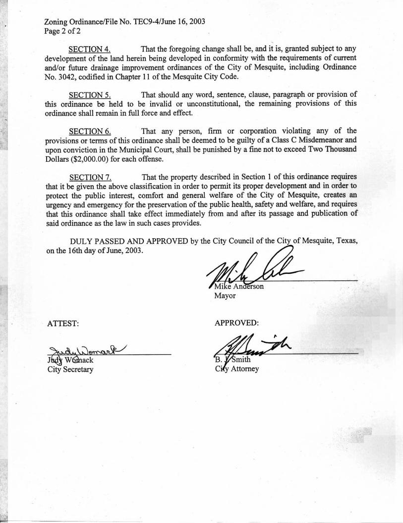
Zoning Ordinance/File No. TEC9-4/June 16, 200 3Page 2 of 2
SECTION 4 . That the foregoing change shall be, and it is, granted subject to anydevelopment of the land herein being developed in conformity with the requirements of curren tand/or future drainage improvement ordinances of the City of Mesquite, including Ordinanc eNo. 3042, codified in Chapter 11 of the Mesquite City Code.
SECTION 5. That should any word, sentence, clause, paragraph or provision o fthis ordinance be held to be invalid or unconstitutional, the remaining provisions of thi sordinance shall remain in full force and effect .
SECTION 6 . That any person, firm or corporation violating any of th eprovisions or terms of this ordinance shall be deemed to be guilty of a Class C Misdemeanor an dupon conviction in the Municipal Court, shall be punished by a fine not to exceed Two Thousan dDollars ($2,000.00) for each offense .
SECTION 7. That the property described in Section 1 of this ordinance require sthat it be given the above classification in order to permit its proper development and in order t oprotect the public interest, comfort and general welfare of the City of Mesquite, creates a nurgency and emergency for the preservation of the public health, safety and welfare, and require sthat this ordinance shall take effect immediately from and after its passage and publication o fsaid ordinance as the law in such cases provides .
DULY PASSED AND APPROVED by the City Council of the City of Mesquite, Texas ,on the 16th day of June, 2003 .
ATTEST:
bee W iackCity Secretary
APPROVED :
Play-23-03 1O :4OA CoDel, Inc_
972 239 9443
P .02
Exhibit "A"F RC)I"
it'E :) U5. 23' U3 1i :29/5T. U8 :23/NU 3W.4dLi3t :
EXHIBIT"A"BEING A 1 .8351 ACRE TRACT OF LAND SITUATED I N
THE CITY Of MESQUITE, DALLAS COUNTY. TEXAS, MDBUNG A PART OF' LOT 1, BLOCK X. TOWN EAST
COMMERCIAL ND. 9, FOURTH SECTION. AS RECORDE DIN VOLUME 78214, PAGE 0012, MAP RECORDS ,
DALLAS COUNTY, TEXAS.
Being all that certain tot, parcel, or tract of land situated in the City of Mesquite . DotlosCounty, Texas, and being a portion of Lot 1 . Block X, TOWN EAST COMMERCIAL NO . 9, FOURT HSECTION, on addition to the City of Mesquite, DCIIOS County, Texas, according to the Ma pthereof recorded in Volume 78214, Page 12, Mop Records, Dafias County, Texas, same tiein gconveyed to Silas A. Bryan Jr . by deed recorded in Volume 94223, Page 3452, Deed Records ,Collar County, Texas. and being more particularly described by males and bounds os follows :
Beginning of a 5/8 inch iron rod found for corner. and being in the SOutheClel line of iJ .S .fiighvrcy No, 87 (Interstate Highway No . 30), (a variable width right-of-way), and being inthe Northeast line of Fair Green Drive (a 50 foot right-of-way) ;
Thence North 61 ()agrees 03 Minutes 00 Seconds East, otang the Southeast line of said U.S .Iftghwoy No. 67, passing o 5/8 inch iron rod at high bank corner with o yellow cap etomlped(DC&A), at a distance of 250.00 feet, and continuing o total distance of 298,47 feet to 0point for corner, and being the Northwest corner of Lot 2, Block X, of said TOWtu EAS TCOMMERCIAL NO . 9, FOURTH SECTION ;
Thence Soutn 29 Degrees 14 Minutes 40 Seconds East . along the West line of said Lot 2, adistance of 103 .47 feet to a point for corner ;
Thence South S8 Degrees 14 Minutes CO Seconds reef . continuing along the aforesaid Wes tline of said Lot 2. a distance of 134 .75 feet to 0 actin' !or corner, and being in the Wes tOne of sold Lot 2, and being the North carrier at the remainder of said Lot 1, Block X, o fsaid TOWN EAST COMMERCIAL NO . 9, FOURTH SECTION;
Thence South 32 Degrees 38 Minutes 31 Seconds West, along the Northwest line of saidremainder of said Lot I , Block X . of said TOWN EAST COMMERCIAL NO . 9, FOURTH SECTION .p assing a 5/8 inch iron rod set of high bank with a yellow cap stomped (DC&A), at 4 .distance of 35 .89 fiat, and continuing q total distance of 68.32 feet to 0 5/8 inch iron rodlet for angle point, and being in the Northwest line of the remainder of sold Lai 1, steal X ,of *aid TOWN EAST COMMERCIAL NO_ 9, FOURTH SECTION ;
Thence South 61 Degrees 03 Minutes 00 Saeonde West, continuing along the Northwest line o fthe remainder of soid Lot 1 . Block X, of sold TOWN EAST COMMERCIAL NO . 9 . FOURT HSECTION, a distance of 304.132 feet to 0 5/B inch iron rod set for corner with a yellow co pstamped (OC&A), and biting in the Northeast tine of sold Fair Green Drive :
Thence North 28 Degrees 57 Minutes 00 Seconds West, continuing along the Norlheoet lino o fsaid Fair Green Drive, q distance of 253 .50 feet it the Point of Beginning and containin g60,50x .90 Squore Feet or 1 .8551 Acres of land .
roe ND. 0305455- 2SLEET 1 Of 2
eetAN CONNALLYRPIS 551 305/22/03
Z0® ' d th ree cA/eZ/S0
OboO-TSL-bTG
5 .. :08¢1,5Ua se1eelrd TO 1 !W
• •u.j, swa . vti .~, v - tvn L.VI ../C I , 1 I IC.: Ml G GJ5 .+YJ r
Exhibit "B ";F'R11 Ut. 23' U3 U .3U/ 1'. :J8 :2 ?NU 3DF :42U3t : ? 4
~XHJBfl' *6,r
EINGV A 1 .8551 . ACRE TRACT OF LAND SITUATED I NTIi CITY OF ?: RITE, DALLAS COUNTY, TEXAS, AN D
BEING A PART OF LOT 1, SLACK X, TOWN EASTCOMMERCIAL. NO. R, FOURTH SECTION, AS RECORDED
IN VOLUME 75214, PAGE 0012, MAP RECORDS ,DALLAS COUNTY, TEXAS .
GENERAL NOTES :
1) a ARIL
ARE SAS,'~ OA THE TOWN EASTCOU 4¢RCIAAL ND. 9, FOURTH SECTION . AN A3DITIOI4TO TM C 17T OF DALLAS. DA LLII , COUNTY, TEXAS ,ACCORDING. TO THE PLAT TH£REOC RECORDED IN'VOLUME 76211 . FADE 00 ;2 . twAP RECD RD3 . CIA LSCOUNTY, 'ERAS .Z) 3/6 ' IRS = S/B INCH IRON ROD SET WIT H7E41O'++ CAP STAMPED tDCRA )
Ob Ara. 0365455- 2;HUT 2 Of' 2
SCALE : 1 "
BRYAN CONIIALL TRr&E 331 3OS/t2/O3
s00' d
eerE? .S~
EbS6-TS4-'17TZ
saTOaa 1
!w
May-27-03 i0 :36A Co-Del, Inc .- .- r .. . .v .+
a- .vr
ar GJJ71fVO9̀J 2 239 9443 P .02
PAGE @1SMA
1
I~ II
lk 11
lei I gilt," ; I°I 1
-lc
i i
1~`F=
az .= I
1111111111"
1!i
: r ' I I
1 -- ' --- ' '
1I ;Fti g r
i%
11
1
I$i
g 1
I1 c /
( 1 1
Exhibit "C"