orbital mechanicshazem-ot/session 3_ sat orbits.pdforbital mechanics part 2. orbital forces why a...
TRANSCRIPT

Orbital MechanicsOrbital Mechanics
Part Part 22

Orbital ForcesOrbital Forces
Why a Sat. remains in Why a Sat. remains in orbit ?orbit ?
BcsBcs thethe centrifugalcentrifugal forceforcecausedcaused byby thethe SatSat.. rotationrotationaroundaround earthearth isis countercounter--balancedbalanced byby thethe Earth'sEarth's PullPull..
rGMvcirc
AA bodybody inin circularcircular motionmotion willwill havehave aaconstantconstant velocityvelocity vcircvcirc determineddetermined byby thetheforceforce itit mustmust “balance”“balance” toto staystay inin orbitorbit
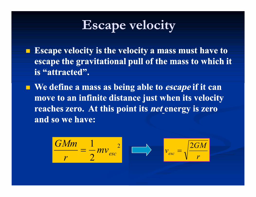
Escape velocityEscape velocity
Escape velocity is the velocity a mass must have to Escape velocity is the velocity a mass must have to escape the gravitational pull of the mass to which it escape the gravitational pull of the mass to which it is “attracted”. is “attracted”.
We define a mass as being able to We define a mass as being able to escapeescape if it can if it can move to an infinite distance just when its velocity move to an infinite distance just when its velocity reaches zero. At this point its reaches zero. At this point its netnet energy is zero energy is zero and so we have: and so we have:
2
21
escmvr
GMm
rGMvesc
2

Escape velocityEscape velocity
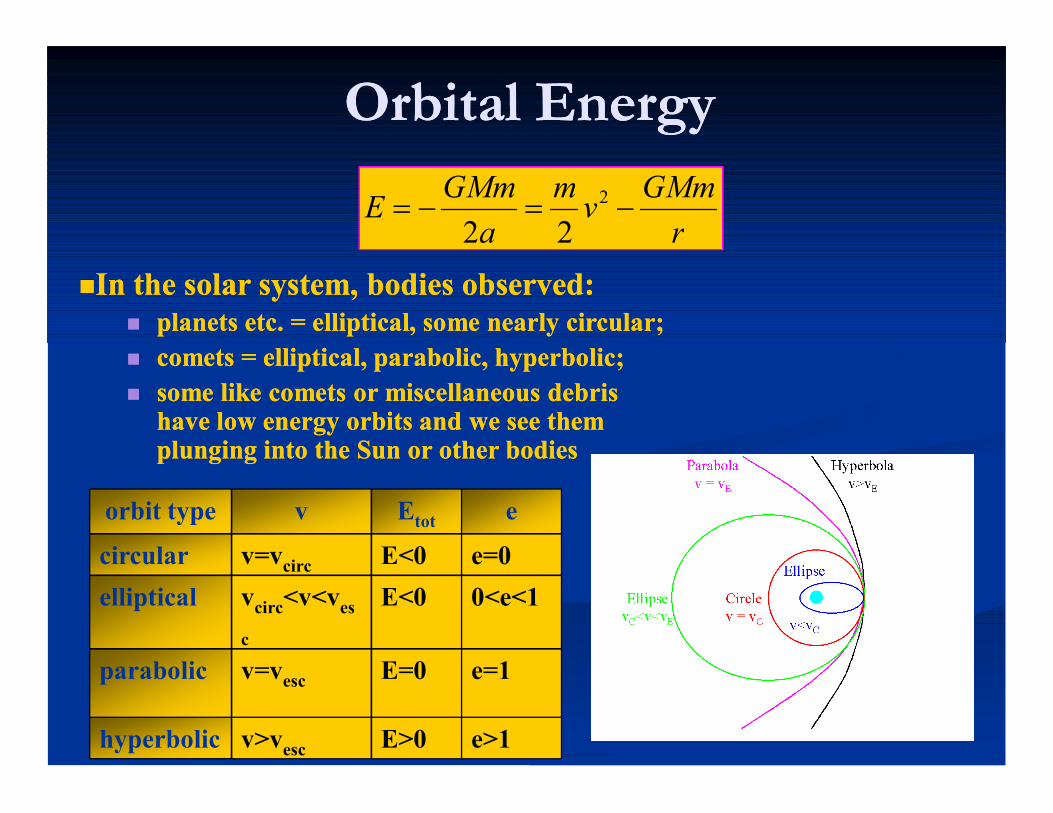
Orbital EnergyOrbital Energy
In the solar system, bodies observed: In the solar system, bodies observed: planets etc. = elliptical, some nearly circular; planets etc. = elliptical, some nearly circular; comets = elliptical, parabolic, hyperbolic; comets = elliptical, parabolic, hyperbolic; some like comets or miscellaneous debris some like comets or miscellaneous debris
have low energy orbits and we see them have low energy orbits and we see them plunging into the Sun or other bodiesplunging into the Sun or other bodies
orbit type v Etot e
circular v=vcirc E<0 e=0elliptical vcirc<v<ves
c
E<0 0<e<1
parabolic v=vesc E=0 e=1
hyperbolic v>vesc E>0 e>1
rGMmvm
aGMmE 2
22

Injection Requirements: SpeedInjection Requirements: Speed
5 m
8 km

Injection Requirements: SpeedInjection Requirements: Speed
100 miles
17,500 mi/hr

Injection Requirements: AltitudeInjection Requirements: Altitude
Are you moving FASTER or SLOWER the Are you moving FASTER or SLOWER the higher your altitude?higher your altitude?

VC = G(m1+m2)a VC = 5.59 km/s
VC = 4.56 km/s2E
3E
Injection Requirements: AltitudeInjection Requirements: Altitude

Injection Requirements: AltitudeInjection Requirements: Altitude
2E
VE = VC 2= 7.91 km/s
VC = 5.59 km/s
V < 7.91 km/sV > 7.91 km/s
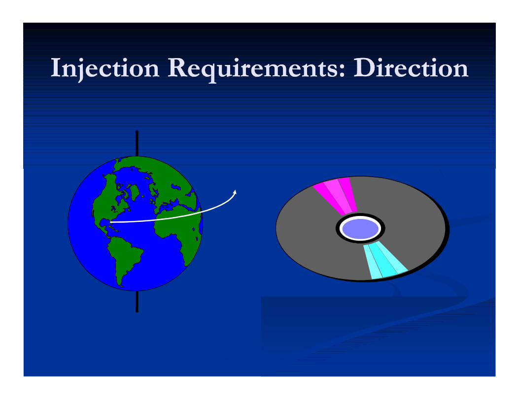
Injection Requirements: DirectionInjection Requirements: Direction

VisVis--Viva EquationViva Equation
Does not depend on orbital eccentricity. Does not depend on orbital eccentricity.
arGMrv
2112)(2
Knowing the relation between orbital energy, Knowing the relation between orbital energy, distance, and velocity we can find a general distance, and velocity we can find a general formula formula the the Vis VivaVis Viva equationequation
If a new object is observed in space, knowing its If a new object is observed in space, knowing its current velocity and distance, we can determine its current velocity and distance, we can determine its orbital semimajor axis, and, thus have some idea orbital semimajor axis, and, thus have some idea where it came from. where it came from.
rGMmvm
aGMm
2
22
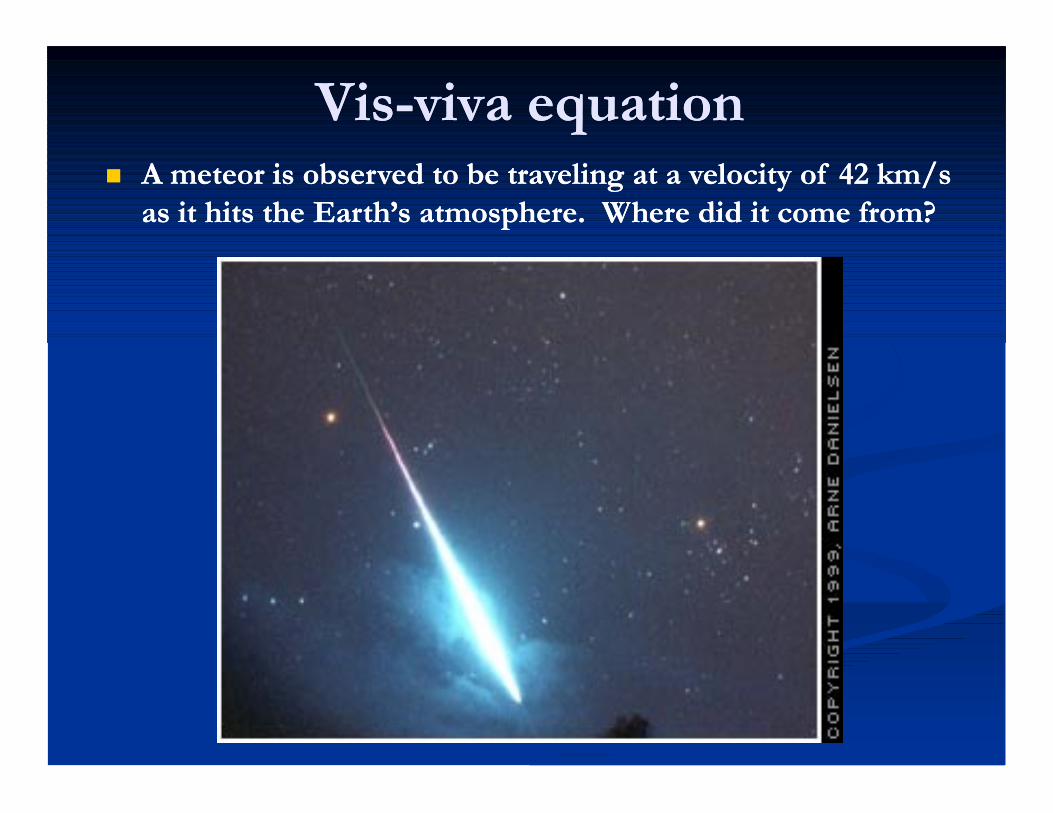
VisVis--viva equationviva equation A meteor is observed to be traveling at a velocity of A meteor is observed to be traveling at a velocity of 42 42 km/s km/s
as it hits the Earth’s atmosphere. Where did it come from?as it hits the Earth’s atmosphere. Where did it come from?

ResonancesResonances If the orbit of a small If the orbit of a small
body around a larger one body around a larger one is a smallis a small--integer fraction integer fraction of the larger body’s of the larger body’s period, the two bodies are period, the two bodies are commensurablecommensurable..
Some resonances (Some resonances (33::2 2 resonance of Jupiter) resonance of Jupiter) actually have a stabilising actually have a stabilising effect.effect.
Example:Example: An asteroid in a An asteroid in a 11::2 2 resonance with Jupiter resonance with Jupiter completes two revolutions, while Jupiter completes onecompletes two revolutions, while Jupiter completes one

Horseshoe orbitsHorseshoe orbits Two small moons of Saturn, Janus and Two small moons of Saturn, Janus and
Epimetheus, only separated by about Epimetheus, only separated by about 50 50 km.km.
As inner (faster moving) moon catches As inner (faster moving) moon catches up with slower moon, it is given a up with slower moon, it is given a gravitational kick into a higher orbit. gravitational kick into a higher orbit.
It then moves more slowly and lags It then moves more slowly and lags behind the other moon.behind the other moon.
Coordinate SystemsCoordinate Systems
Defines positions and directions in a consistent Defines positions and directions in a consistent manner manner ---- allows communicationallows communication
Facilitates the description of a satellite’s position Facilitates the description of a satellite’s position and subsequent motionand subsequent motion
Proper choice of reference determines the utility Proper choice of reference determines the utility of a coordinate systemof a coordinate system

Coordinate SystemsCoordinate SystemsClassificationsClassifications
InertialInertialNonNon--rotatingrotatingTime IndependentTime Independent
NonNon--inertialinertialRotatingRotatingTime DependentTime Dependent
Coordinate SystemsCoordinate SystemsExamplesExamples
GeographicGeographic Geocentric InertialGeocentric Inertial TopocentricTopocentric Orbit InertialOrbit Inertial

Coordinate SystemsCoordinate SystemsGeographicGeographic
Purpose: To locate points on the Earth’s Purpose: To locate points on the Earth’s surfacesurface

Coordinate SystemsCoordinate SystemsGeographicGeographic
Purpose: To locate points on the Earth’s Purpose: To locate points on the Earth’s surfacesurface

Coordinate SystemsCoordinate SystemsGeocentric InertialGeocentric Inertial
Purpose: To determine the exact orientation of an Purpose: To determine the exact orientation of an orbital plane and to locate points in space with respect orbital plane and to locate points in space with respect to the Earthto the Earth
Vernal EquinoxEquatorialPlane
Ecliptic Plane

Coordinate SystemsCoordinate SystemsGeocentric InertialGeocentric Inertial
Inclination

Coordinate SystemsCoordinate SystemsGeocentric InertialGeocentric Inertial
VernalEquinox
Ascending Node
Direction of Satellite motion
Right Ascension

The Orbital PlaneThe Orbital Plane
vear
cos21)1( 2
EeEM sin
In the orbital plane, the In the orbital plane, the position vector position vector rr and and velocity vector velocity vector vv specify specify the motion of the the motion of the satellite.satellite.
Knowing the mean anaomaly, the eccentric anamaly E : Knowing the mean anaomaly, the eccentric anamaly E :
(Iterative Sol.)(Iterative Sol.) 0sin EeEM
Knowing E: Knowing E: )2
tan(11)
2tan( E
eev
)cos21( Ear
MeMeMv 2sin45sin2 2 For near Circular Orbits (eFor near Circular Orbits (e00):):

ExampleExample

ExampleExample

ExampleExample
vear
cos21)1( 2
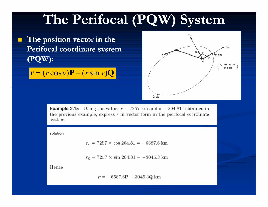
The Perifocal (PQW) SystemThe Perifocal (PQW) System The position vector in the The position vector in the
Perifocal coordinate system Perifocal coordinate system (PQW): (PQW):
QPr )sin()cos( vrvr
PQW is conveniet for motion PQW is conveniet for motion descrptiondescrption
Equatorial Bulge causes Equatorial Bulge causes rotationsof PQW systemrotationsof PQW system
Geocentric is suitable: Geocentric is suitable: refernced to fixed starsrefernced to fixed stars
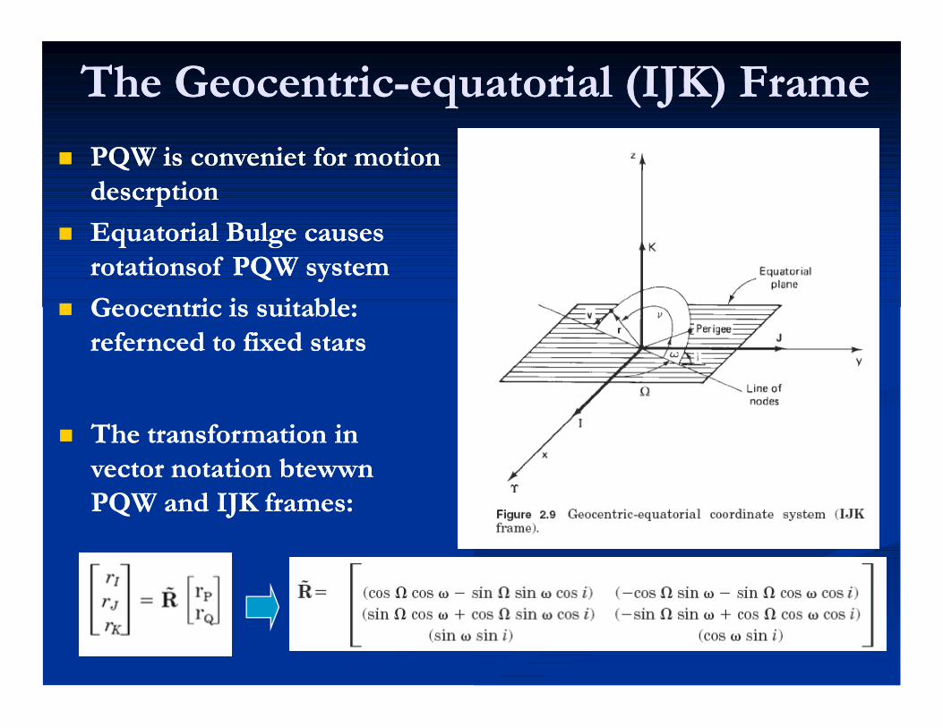
The GeocentricThe Geocentric--equatorial (IJK) Frameequatorial (IJK) Frame
The transformation in The transformation in vector notation btewwn vector notation btewwn PQW and IJK frames: PQW and IJK frames:

ExampleExample
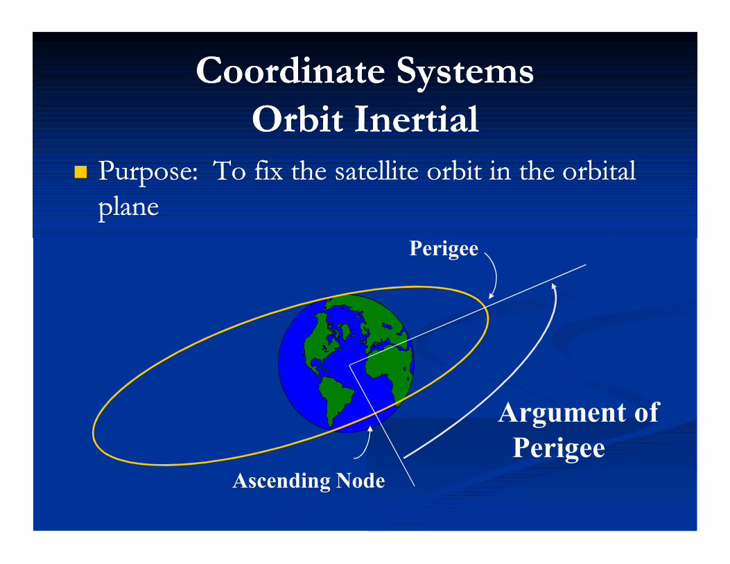
Coordinate SystemsCoordinate SystemsOrbit InertialOrbit Inertial
Purpose: To fix the satellite orbit in the orbital Purpose: To fix the satellite orbit in the orbital planeplane
Argument ofPerigee
Ascending Node
Perigee

Coordinate SystemsCoordinate SystemsTopocentricTopocentric
Purpose: To locate a satellite with respect to a Purpose: To locate a satellite with respect to a specific point on the Earthspecific point on the Earth

Coordinate SystemsCoordinate SystemsTopocentricTopocentric
Elevation

Coordinate SystemsCoordinate SystemsTopocentricTopocentric
Azimuth
Range
Origin: AntennaFP: Local HorizonPD: True North
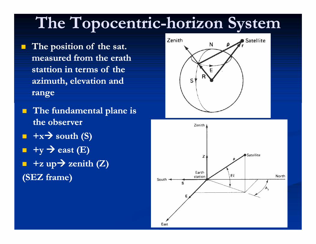
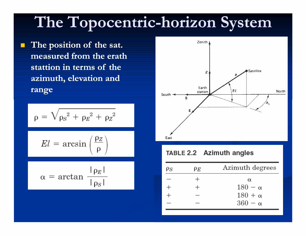
The TopocentricThe Topocentric--horizon Systemhorizon System The position of the sat. The position of the sat.
measured from the erath measured from the erath stattion in terms of the stattion in terms of the azimuth, elevation and azimuth, elevation and rangerange
The fundamental plane is The fundamental plane is the observerthe observer
+x+x south (S)south (S) +y +y east (E)east (E) +z up+z up zenith (Z)zenith (Z)(SEZ frame)(SEZ frame)
The TopocentricThe Topocentric--horizon Systemhorizon System The position of the sat. The position of the sat.
measured from the erath measured from the erath stattion in terms of the stattion in terms of the azimuth, elevation and azimuth, elevation and rangerange

ExampleExample Given Given


Coordinate SystemsCoordinate SystemsOrbit InertialOrbit Inertial
Purpose: To fix the satellite orbit in the orbital Purpose: To fix the satellite orbit in the orbital planeplane
Argument ofPerigee
Ascending Node
Perigee
Orbit ClassificationOrbit Classification
Size/PeriodSize/Period LocationLocation ShapeShape

Size/PeriodSize/Period
Defined by semiDefined by semi--major axis (a)major axis (a) Low Earth Orbit (LEO)Low Earth Orbit (LEO) High Earth Orbit (HEO)High Earth Orbit (HEO) SemiSemi--synchronous Orbitsynchronous Orbit GeoGeo--synchronous Orbitsynchronous Orbit
Orbit ClassificationOrbit Classification

LocationLocation
EquatorialEquatorial PolarPolar
Orbit ClassificationOrbit Classification
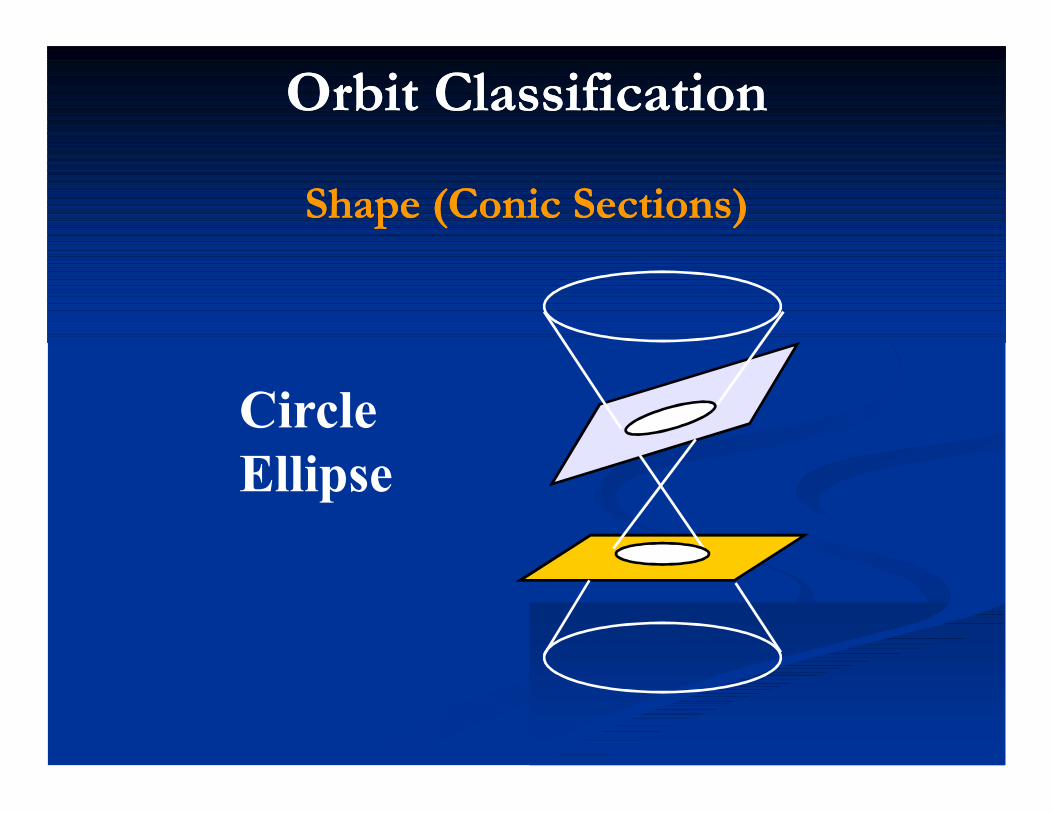
Shape (Conic Sections)Shape (Conic Sections)
CircleEllipse
Orbit ClassificationOrbit Classification

Trajectories:ParabolaHyperbola
Shape (Conic Sections)Shape (Conic Sections)
Orbit ClassificationOrbit Classification

ORBIT CLASSIFICATIONSORBIT CLASSIFICATIONSCircular OrbitsCircular Orbits
CharacteristicsCharacteristics Constant speedConstant speed Nearly constant altitudeNearly constant altitude
Typical MissionsTypical Missions Reconnaissance/Weather (DMSP)Reconnaissance/Weather (DMSP) MannedManned Navigational (GPS)Navigational (GPS) GeoGeo--synchronous (Comm sats)synchronous (Comm sats)

ORBIT CLASSIFICATIONSORBIT CLASSIFICATIONSElliptical OrbitsElliptical Orbits
CharacteristicsCharacteristics Varying speedVarying speed Varying altitudeVarying altitude Asymmetric Ground TrackAsymmetric Ground Track
Typical MissionsTypical Missions Deep space surveillance (Pioneer)Deep space surveillance (Pioneer) Communications (Polar comm.)Communications (Polar comm.) Ballistic MissilesBallistic Missiles

ORBIT CLASSIFICATIONSORBIT CLASSIFICATIONSParabolic/Hyperbolic TrajectoriesParabolic/Hyperbolic Trajectories
CharacteristicsCharacteristics Escaped Earth’s gravitational influenceEscaped Earth’s gravitational influence HeliocentricHeliocentric
Typical MissionsTypical Missions Interplanetary exploration (Galileo, Interplanetary exploration (Galileo,
Phobos, Magellan)Phobos, Magellan)

ORBIT CLASSIFICATIONSORBIT CLASSIFICATIONSOrbit GeometryOrbit Geometry
Apogee
Perigee
cc
aEccentricity = c/a

ORBIT CLASSIFICATIONSORBIT CLASSIFICATIONSEccentricityEccentricity
e = 0
0 < e < 1
e = 1
e > 1

ORBIT CLASSIFICATIONSORBIT CLASSIFICATIONSEccentricityEccentricity
e = 0
a
c = 0
0 < e < 1
c
a
Eccentricity = c/a

ORBIT CLASSIFICATIONSORBIT CLASSIFICATIONSEccentricityEccentricity
Eccentricity = c/a
e = 0.75
e = .45
e = 0

ORBITAL MECHANICSORBITAL MECHANICS
OriginsOrigins Physical LawsPhysical Laws Requirements for InjectionRequirements for Injection Classifications of OrbitsClassifications of Orbits Coordinate Reference SystemsCoordinate Reference Systems Orbital ElementsOrbital Elements

SatellitesSatellites
Several typesSeveral types LEOs LEOs -- Low earth orbitLow earth orbit MEOs MEOs -- Medium earth orbitMedium earth orbit GEOs GEOs -- Geostationary earth orbitGeostationary earth orbit
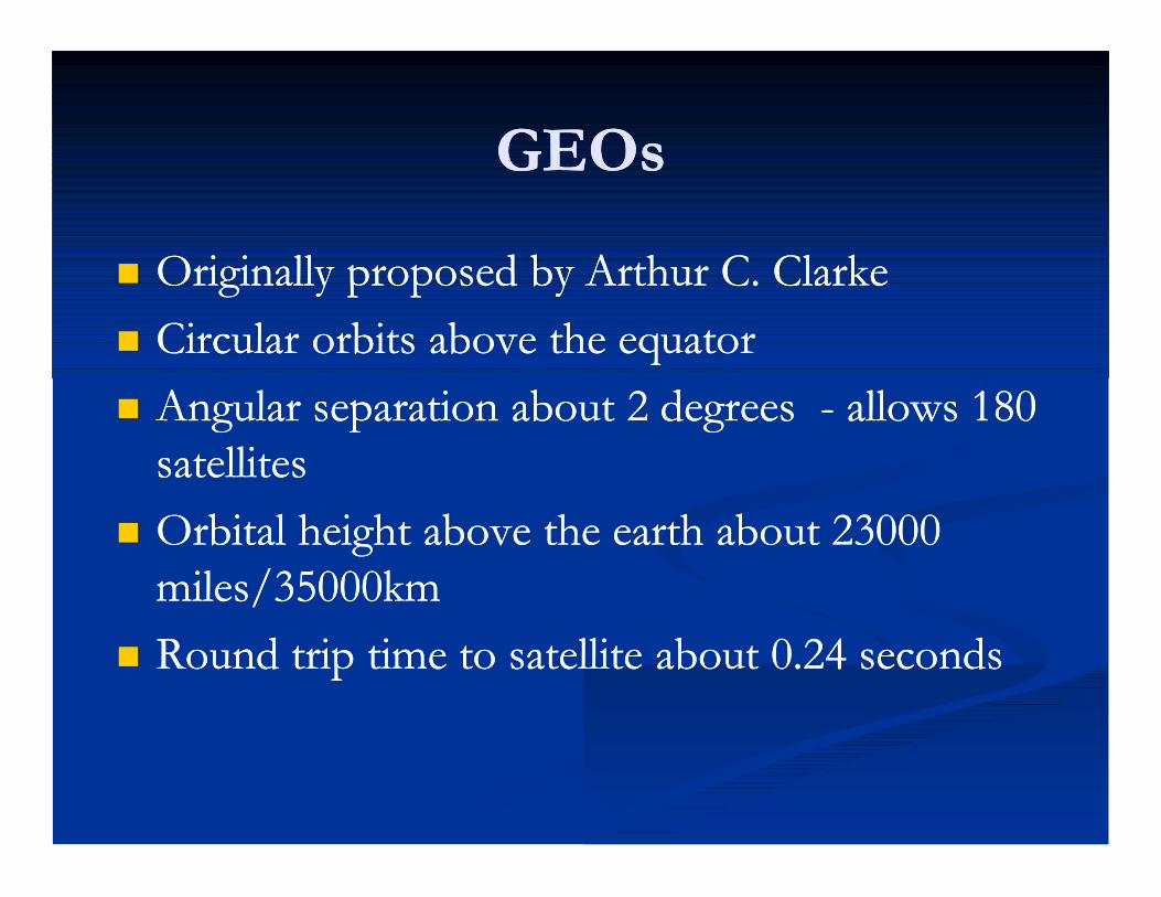
GEOsGEOs
Originally proposed by Arthur C. ClarkeOriginally proposed by Arthur C. Clarke Circular orbits above the equatorCircular orbits above the equator Angular separation about Angular separation about 2 2 degrees degrees -- allows allows 180 180
satellitessatellites Orbital height above the earth about Orbital height above the earth about 23000 23000
miles/miles/3500035000kmkm Round trip time to satellite about Round trip time to satellite about 00..24 24 secondsseconds
GEOs (GEOs (22))
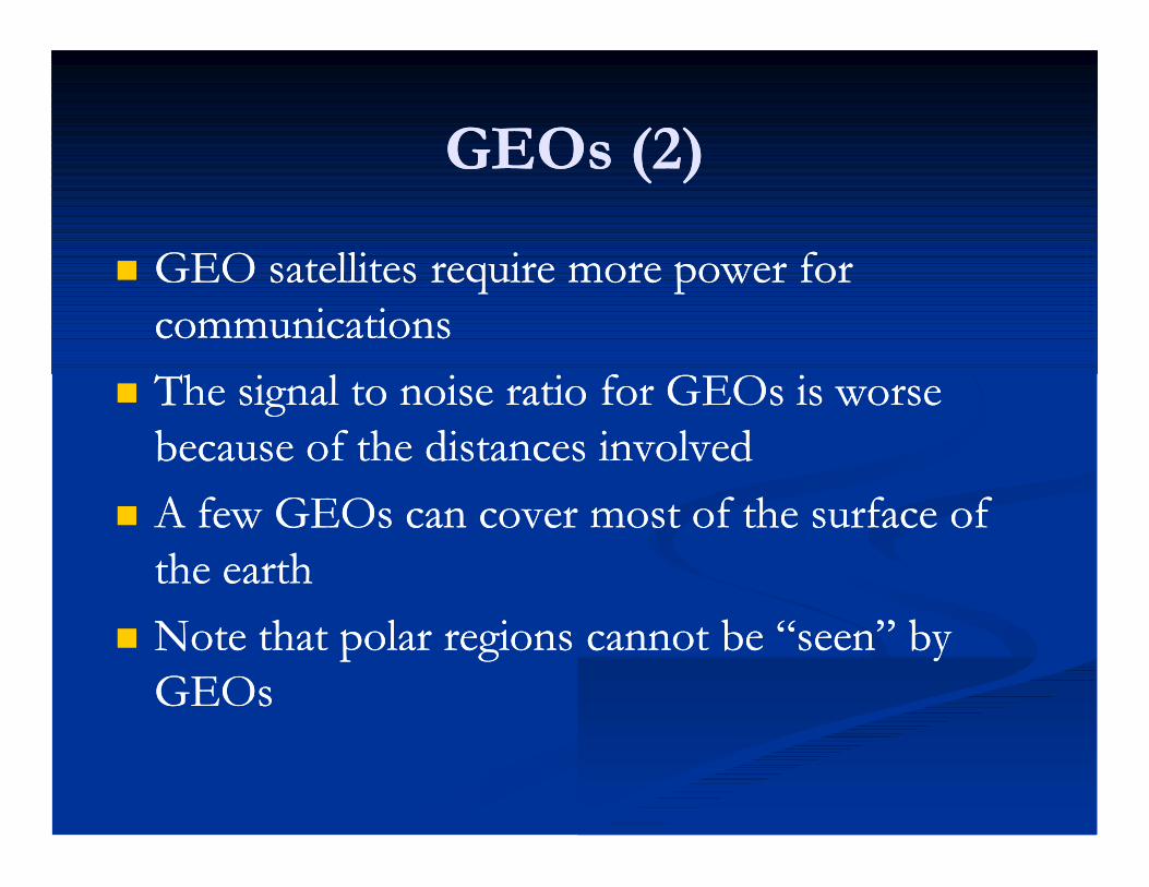
GEO satellites require more power for GEO satellites require more power for communicationscommunications
The signal to noise ratio for GEOs is worse The signal to noise ratio for GEOs is worse because of the distances involvedbecause of the distances involved
A few GEOs can cover most of the surface of A few GEOs can cover most of the surface of the earththe earth
Note that polar regions cannot be “seen” by Note that polar regions cannot be “seen” by GEOsGEOs
GEOs (GEOs (33))
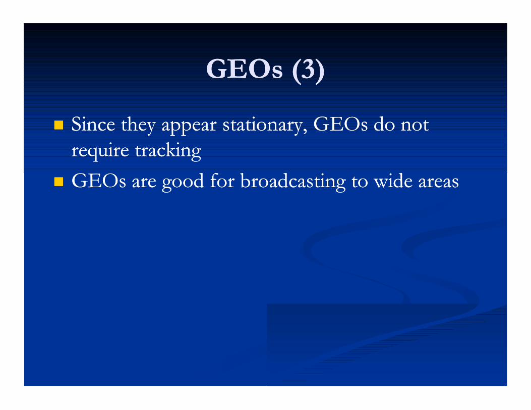
Since they appear stationary, GEOs do not Since they appear stationary, GEOs do not require trackingrequire tracking
GEOs are good for broadcasting to wide areasGEOs are good for broadcasting to wide areas

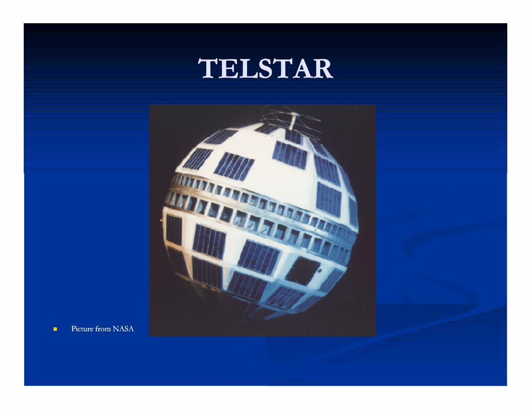
TELSTARTELSTAR
Picture from NASAPicture from NASA
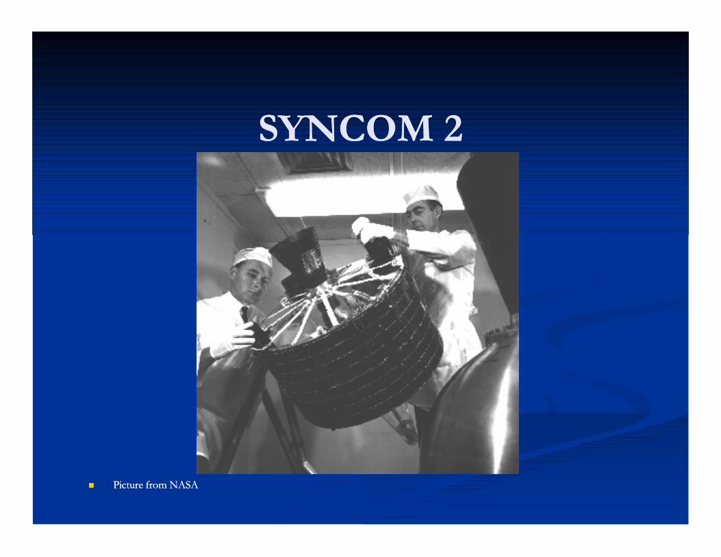
SYNCOM SYNCOM 22
Picture from NASAPicture from NASA


Satellite OrbitsSatellite Orbits인공위성인공위성궤도궤도
원격지구물리 2004년 1학기 3월 11일 목요일 1교시
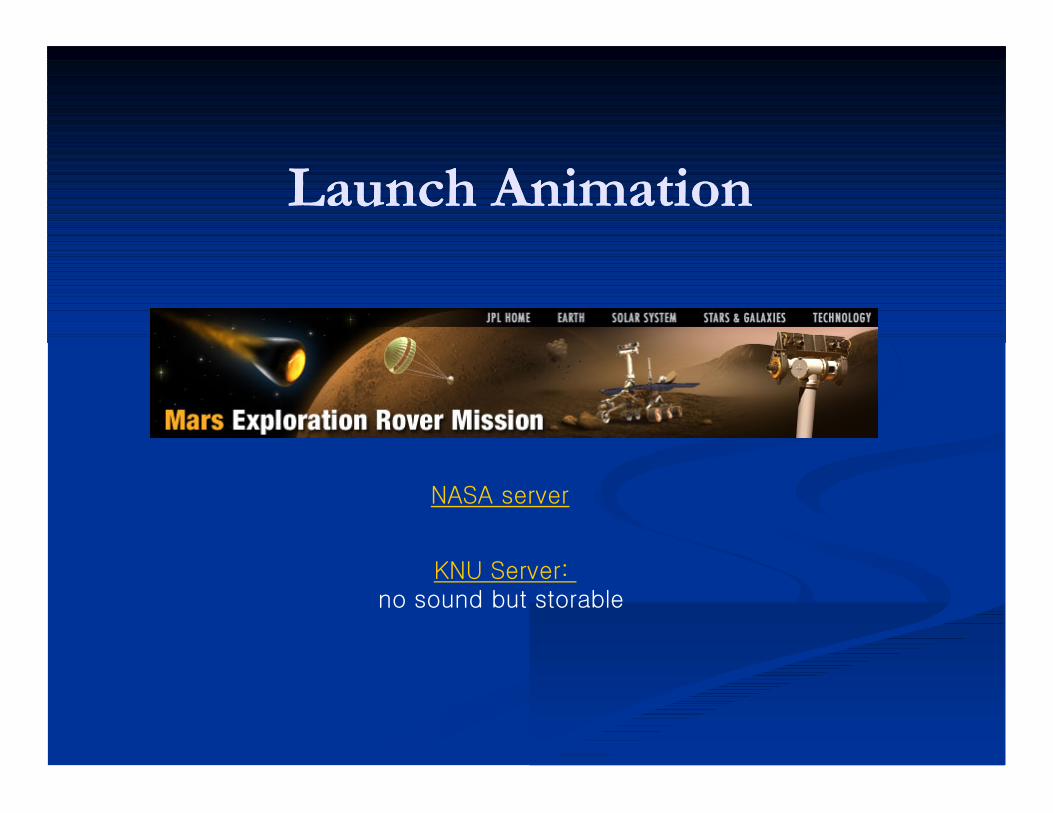
Launch AnimationLaunch Animation
NASA server
KNU Server: no sound but storable

Low Earth OrbitsLow Earth Orbits저궤도저궤도
Close to Earth (Close to Earth (320320~~800800km)km) ~~2727,,000 000 km/hkm/h 9090min periodmin period
Space ShuttleSpace Shuttle Some Remote Sensing Some Remote Sensing
Satellites and weather Satellites and weather satellitessatellites
~~88,,000 000 Space Junks Space Junks ––satellites, old rockets, metals, satellites, old rockets, metals, etc. etc.

Polar OrbitPolar Orbit극궤도극궤도
One type of LEOOne type of LEO High inclinationHigh inclination Can scan the entire Can scan the entire
surface due to earth surface due to earth rotation (eastrotation (east--west) west) and satellite orbit and satellite orbit (north(north--south)south)
Most remote sensing Most remote sensing satellites and some satellites and some weather satellitesweather satellites

SunSun--synchronous Orbitsynchronous Orbit These orbits allows a satellite to pass over a These orbits allows a satellite to pass over a
section of the Earth at the same time of day. section of the Earth at the same time of day. Since there are Since there are 365 365 days in a year and days in a year and 360 360 degrees degrees
in a circle, it means that the satellite has to shift its in a circle, it means that the satellite has to shift its orbit by approximately one degree per day. orbit by approximately one degree per day.
These satellites orbit at an altitude between These satellites orbit at an altitude between 700 700 to to 800 800 km. km.
These satellites use the fact since the Earth is not These satellites use the fact since the Earth is not perfectly round (the Earth bulges in the center, the perfectly round (the Earth bulges in the center, the bulge near the equator will cause additional bulge near the equator will cause additional gravitational forces to act on the satellite. gravitational forces to act on the satellite.
This causes the satellite's orbit to either proceed or This causes the satellite's orbit to either proceed or recede. recede.
These orbits are used for satellites that need a These orbits are used for satellites that need a constant amount of sunlight.constant amount of sunlight.
Satellites that take pictures of the Earth would Satellites that take pictures of the Earth would work best with bright sunlight, while satellites that work best with bright sunlight, while satellites that measure longwave radiation would work best in measure longwave radiation would work best in complete darkness. complete darkness.

Fig. 4: Conceptual illustration of the WatER mission
0.28 mAntenna width
9000 HzPRF (2 antennas)
800 WMean instrument power
4.3 degFar range view angle
0.6 degNear range view angle
10 mMast length
3.80 mAntenna length
1500 WPeak emission power
6,3 μsPulse duration
200 MHzBandwidth
Ka (36.5 GHz)Frequency
16 daysCycle duration
98.705 ºInclination
824.03 kmAltitude
Resolution:
10 m (FR) 70 m (NR)
Interferometric swathPolarisation H
Interferometric swathPolarisation V
50 km 50 km10 km10 km
3.6°
0.6°
2 m
Speed vectorSun direction
in a 32deg half cone
Perpendicular to the orbit
AltiKanadirswath
0.28 mAntenna width
9000 HzPRF (2 antennas)
800 WMean instrument power
4.3 degFar range view angle
0.6 degNear range view angle
10 mMast length
3.80 mAntenna length
1500 WPeak emission power
6,3 μsPulse duration
200 MHzBandwidth
Ka (36.5 GHz)Frequency
16 daysCycle duration
98.705 ºInclination
824.03 kmAltitude
Resolution:
10 m (FR) 70 m (NR)
Interferometric swathPolarisation H
Interferometric swathPolarisation V
50 km 50 km10 km10 km
3.6°3.6°
0.6°0.6°
2 m
Speed vectorSun direction
in a 32deg half cone
Perpendicular to the orbit
AltiKanadirswath
Reminder : WATER MISSION on a Sun-Sync. orbit
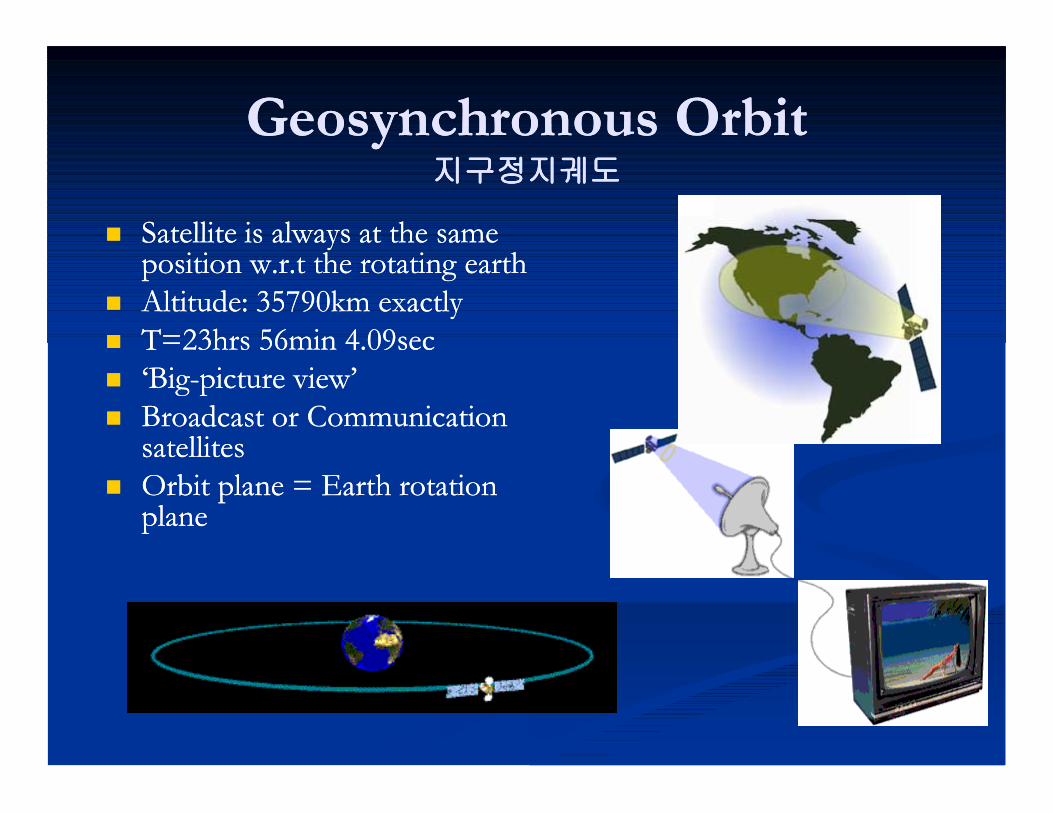
Geosynchronous OrbitGeosynchronous Orbit지구정지궤도지구정지궤도
Satellite is always at the same Satellite is always at the same position w.r.t the rotating earthposition w.r.t the rotating earth
Altitude: Altitude: 3579035790km exactlykm exactly T=T=2323hrs hrs 5656min min 44..0909secsec ‘Big‘Big--picture view’picture view’ Broadcast or Communication Broadcast or Communication
satellitessatellites Orbit plane = Earth rotation Orbit plane = Earth rotation
planeplane
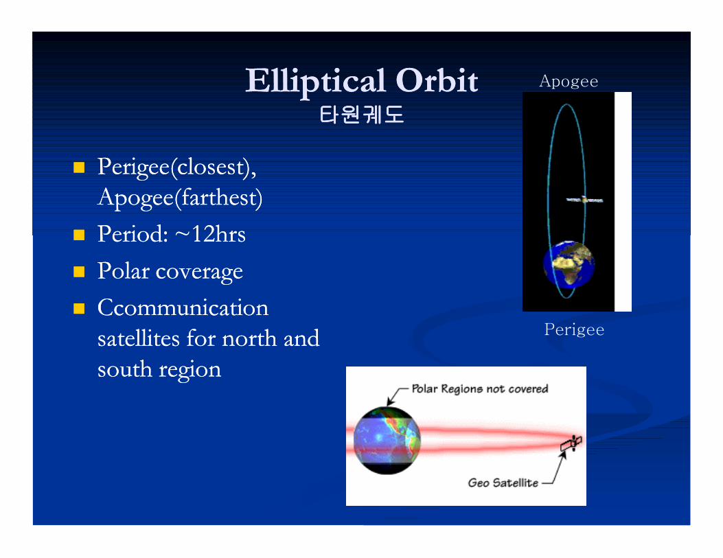
Elliptical OrbitElliptical Orbit타원궤도타원궤도
Perigee(closest), Perigee(closest), Apogee(farthest)Apogee(farthest)
Period: ~Period: ~1212hrshrs Polar coverage Polar coverage Ccommunication Ccommunication
satellites for north and satellites for north and south regionsouth region
Perigee
Apogee

Orbit Size and ShapeOrbit Size and ShapeParameter DefinitionParameter Definition Semimajor Axis: Semimajor Axis: Half the distance between Half the distance between
the two points in the orbit that are farthest the two points in the orbit that are farthest apartapart
Apogee/Perigee Radius: Apogee/Perigee Radius: Measured from Measured from the center of the Earth to the points of the center of the Earth to the points of maximum and minimum radius in the orbitmaximum and minimum radius in the orbit
Apogee/Perigee Altitude: Apogee/Perigee Altitude: Measured from Measured from the "surface" of the Earth (a theoretical sphere the "surface" of the Earth (a theoretical sphere with a radius equal to the equatorial radius of with a radius equal to the equatorial radius of the Earth) to the points of maximum and the Earth) to the points of maximum and minimum radius in the orbitminimum radius in the orbit
Period: Period: The duration of one orbit, based on The duration of one orbit, based on assumed twoassumed two--body motionbody motion
Mean Motion: Mean Motion: The number of orbits per The number of orbits per solar day (solar day (8686,,400 400 sec/sec/24 24 hour), based on hour), based on assumed twoassumed two--body motionbody motion
Eccentricity: Eccentricity: The shape of the ellipse The shape of the ellipse comprising the orbit, ranging between a comprising the orbit, ranging between a perfect circle (eccentricity = perfect circle (eccentricity = 00) and a parabola ) and a parabola (eccentricity = (eccentricity = 11))
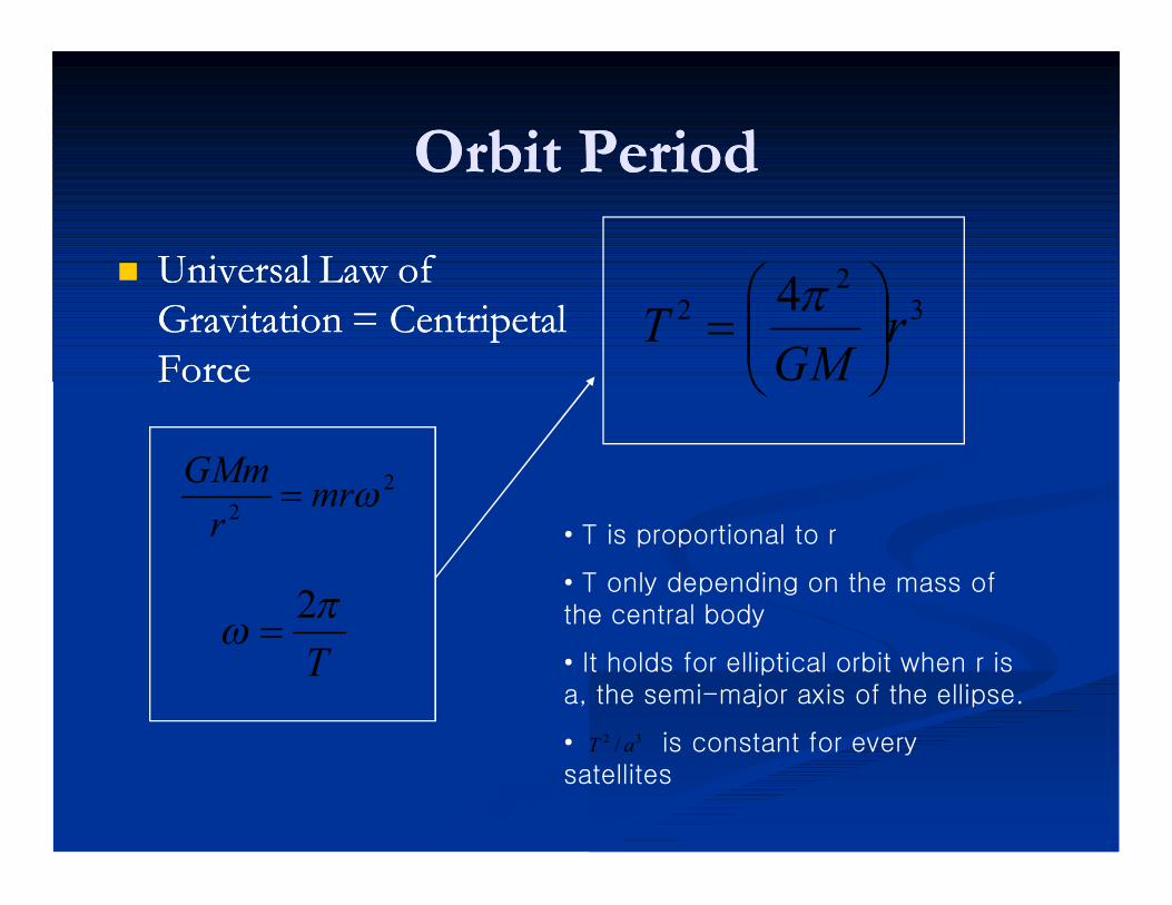
Orbit PeriodOrbit Period
Universal Law of Universal Law of Gravitation = Centripetal Gravitation = Centripetal ForceForce
T 2
22 mrr
GMm
32
2 4 rGM
T
• T is proportional to r
• T only depending on the mass of the central body
• It holds for elliptical orbit when r is a, the semi-major axis of the ellipse.
• is constant for every satellites
32 / aT
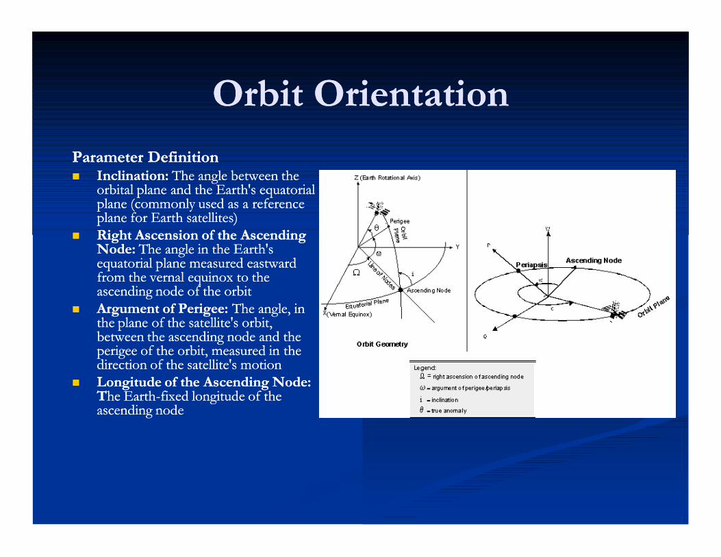
Orbit OrientationOrbit OrientationParameter DefinitionParameter Definition Inclination: Inclination: The angle between the The angle between the
orbital plane and the Earth's equatorial orbital plane and the Earth's equatorial plane (commonly used as a reference plane (commonly used as a reference plane for Earth satellites)plane for Earth satellites)
Right Ascension of the Ascending Right Ascension of the Ascending Node: Node: The angle in the Earth's The angle in the Earth's equatorial plane measured eastward equatorial plane measured eastward from the vernal equinox to the from the vernal equinox to the ascending node of the orbitascending node of the orbit
Argument of Perigee: Argument of Perigee: The angle, in The angle, in the plane of the satellite's orbit, the plane of the satellite's orbit, between the ascending node and the between the ascending node and the perigee of the orbit, measured in the perigee of the orbit, measured in the direction of the satellite's motiondirection of the satellite's motion
Longitude of the Ascending Node: Longitude of the Ascending Node: TThe Earthhe Earth--fixed longitude of the fixed longitude of the ascending nodeascending node

Satellite LocationSatellite LocationParameter DefinitionParameter Definition True Anomaly: True Anomaly: The angle from the The angle from the
eccentricity vector (points toward perigee) to eccentricity vector (points toward perigee) to the satellite position vector, measured in the the satellite position vector, measured in the direction of satellite motion and in the orbit direction of satellite motion and in the orbit plane.plane.
Mean Anomaly: Mean Anomaly: The angle from the The angle from the eccentricity vector to a position vector where eccentricity vector to a position vector where the satellite would be if it were always moving the satellite would be if it were always moving at its angular rate.at its angular rate.
Eccentric Anomaly: Eccentric Anomaly: An angle measured with An angle measured with an origin at the center of an ellipse from the an origin at the center of an ellipse from the direction of perigee to a point on a direction of perigee to a point on a circumscribing circle from which a line circumscribing circle from which a line perpendicular to the semimajor axis intersects perpendicular to the semimajor axis intersects the position of the satellite on the ellipse. the position of the satellite on the ellipse.
Argument of Latitude: Argument of Latitude: The sum of the True The sum of the True Anomaly and the Argument of Perigee.Anomaly and the Argument of Perigee.
Time Past Ascending Node: Time Past Ascending Node: The elapsed The elapsed time since the last ascending node crossing.time since the last ascending node crossing.
Time Past Perigee: Time Past Perigee: The elapsed time since The elapsed time since last perigee passage.last perigee passage.


INCLINATIONFUNCTION OF LAUNCH AZIMUTH AND LAUNCH SITE LATITUDE
cos i (inclination) = cos (latitude) sin (azimuth)
azimuth
N
S
270o
North = 0 degrees Azimuth
90o
180o
cos i + cos (lat) sin (az)
sin 90o = 1sin 0o = 0sin 180o = 0sin 270o = -1
launch azimuth from 180o to360o = retrograde orbit
launch azimuth from 0o to 180o = posigrade orbit
East
South
West

CelestialEquator
Argument ofPerigee (w)
Perigee
Inclination
Right Ascension W
Orbit Trace
Celestial Sphere

ORBITAL MECHANICS: GROUND TRACES
GROUND TRACES
THE POINTS ON THE EARTH’S SURFACE OVER WHICH A SATELLITE PASSES AS IT TRAVELS ALONG ITS ORBIT
PRINCIPLE : GROUND TRACE IS THE RESULT OF THE ORBITAL PLANE BEING FIXED AND THE EARTH ROTATING UNDERNEATH IT
AMPLITUDE OF GROUND TRACE (LATITUDE RANGE) IS EQUAL TO THE ORBITAL INCLINATION
MOVEMENT OF GROUND TRACE IS DICTATED BY THE SATELLITE ALTITUDE AND THE CORRESPONDING TIME FOR IT TO COMPLETE ONE ORBIT
ORBIT 4ORBIT 3
ORBIT 2ORBIT 1
EQUATORIAL ORBIT
INCLINED ORBIT
ANGLE OF INCLINATION(0 DEG. FOR EQUATORIAL)
MULTIPLE ORBITS
SAT
EARTH MOTION BENEATH SATELLITE
ORBITAL MECHANICS: SPECIFIC ORBITS AND APPLICATIONS
• POLAR (100- 700 NM AT 80 - 100 DEG. INCLINATION)
– SATELLITE PASSES THROUGH THE EARTH'S SHADOW AND PERMITS VIEWING OF THE ENTIRE EARTH’S SURFACE EACH DAY WITH A SINGLE SATELLITE
• SUN SYNCHRONOUS (80 - 800 NM AT 95 - 105 DEG INCLINATION)
– PROCESSION OF ORBITAL PLANE SYNCHRONIZED WITH THE EARTH’S ROTATION SO SATELLITE IS ALWAYS IN VIEW OF THE SUN
– PERMITS OBSERVATION OF POINTS ON THE EARTH AT THE SAME TIME EACH DAY
• SEMISYNCHRONOUS (10,898 NM AT 55 DEG INCLINATION)
– 12 HR PERIODS PERMITTING IDENTICAL GROUNDTRACES EACH DAY
• HIGHLY INCLINED ELLIPTICAL (FIXED PERIGEE POSITION)
– SATELLITE SPENDS A GREAT DEAL OF TIME NEAR THE APOGEE COVERING ONE HEMISPHERE
– CLASSICALLY CALLED “MOLNIYA ORBIT” BECAUSE OF ITS HEAVY USE BY THE RUSSIANS FOR NORTHERN HEMISPHERE COVERAGE
• GEOSYNCHRONOUS (GEO) (CIRCULAR, 19,300 NM AT 0 DEG INCLINATION)
– 24 HR PERIOD PERMITS SATELLITE POSITIONING OVER ONE POINT ON EARTH.
– ORBITAL PERIOD SYNCHRONIZED WITH THE EARTH’S ROTATION (NO OTHER ORBIT HAS THIS FEATURE)

(1 radian = 57.3 degrees)
LINEAR MOTION
S = r q ft
Vtangential = r w ft/sec
atangential = r a ft/sec2
Linear and Angular Motion
wf = wo + a t
q = wo t + a t2
2
Distance
Velocity
Acceleration aavg = wf wo
tf to
radianssec2
qfwavg =
tf to
radianssec
qf
S/r radiansq =
ANGULAR MOTION
Major problems for satellitesMajor problems for satellites
Positioning in orbitPositioning in orbit StabilityStability PowerPower CommunicationsCommunications Harsh environmentHarsh environment
PositioningPositioning
This can be achieved by several methodsThis can be achieved by several methods One method is to use small rocket motors One method is to use small rocket motors These use fuel These use fuel -- over half of the weight of most over half of the weight of most
satellites is made up of fuelsatellites is made up of fuel Often it is the fuel availability which determines Often it is the fuel availability which determines
the lifetime of a satellitethe lifetime of a satellite Commercial life of a satellite typically Commercial life of a satellite typically 1010--15 15
yearsyears

StabilityStability
It is vital that satellites are stabilisedIt is vital that satellites are stabilised to ensure that solar panels are aligned properlyto ensure that solar panels are aligned properly to ensure that communications antennae are aligned to ensure that communications antennae are aligned
properlyproperly Early satellites used spin stabilisationEarly satellites used spin stabilisation
Either this required an inefficient omniEither this required an inefficient omni--directional directional aerialaerial
Or antennae were precisely counterOr antennae were precisely counter--rotated in order rotated in order to provide stable communicationsto provide stable communications

Stability (Stability (22))
Modern satellites use reaction wheel stabilisation Modern satellites use reaction wheel stabilisation -- a form of gyroscopic stabilisation Other a form of gyroscopic stabilisation Other methods of stabilisation are also possiblemethods of stabilisation are also possible
including:including: eddy currrent stabilisationeddy currrent stabilisation (forces act on the satellite as it moves through the (forces act on the satellite as it moves through the
earth’s magnetic field)earth’s magnetic field)

Reaction wheel stabilisationReaction wheel stabilisation
Heavy wheels which rotate at high speed Heavy wheels which rotate at high speed -- often often in groups of in groups of 44..
3 3 are orthogonal, and the are orthogonal, and the 44th (spare) is a backup th (spare) is a backup at an angle to the othersat an angle to the others
Driven by electric motors Driven by electric motors -- as they speed up or as they speed up or slow down the satellite rotatesslow down the satellite rotates
If the speed of the wheels is inappropriate, If the speed of the wheels is inappropriate, rocket motors must be used to stabilise the rocket motors must be used to stabilise the satellite satellite -- which uses fuelwhich uses fuel

PowerPower
Modern satellites use a variety of power meansModern satellites use a variety of power means Solar panels are now quite efficient, so solar Solar panels are now quite efficient, so solar
power is used to generate electricitypower is used to generate electricity Batteries are needed as sometimes the satellites Batteries are needed as sometimes the satellites
are behind the earth are behind the earth -- this happens about half this happens about half the time for a LEO satellitethe time for a LEO satellite
Nuclear power has been used Nuclear power has been used -- but not but not recommendedrecommended

Harsh EnvironmentHarsh Environment
Satellite components need to be specially Satellite components need to be specially “hardened”“hardened”
Circuits which work on the ground will fail very Circuits which work on the ground will fail very rapidly in spacerapidly in space
Temperature is also a problem Temperature is also a problem -- so satellites use so satellites use electric heaters to keep circuits and other vital electric heaters to keep circuits and other vital parts warmed up parts warmed up -- they also need to control the they also need to control the temperature carefullytemperature carefully
AlignmentAlignment
There are a number of components which need There are a number of components which need alignmentalignment Solar panelsSolar panels AntennaeAntennae
These have to point at different parts of the sky These have to point at different parts of the sky at different times, so the problem is not trivialat different times, so the problem is not trivial

Antennae alignmentAntennae alignment
A parabolic dish can be used which is pointing A parabolic dish can be used which is pointing in the correct general directionin the correct general direction
Different feeder “horns” can be used to direct Different feeder “horns” can be used to direct outgoing beams more preciselyoutgoing beams more precisely
Similarly for incoming beamsSimilarly for incoming beams A modern satellite should be capable of at least A modern satellite should be capable of at least
50 50 differently directed beamsdifferently directed beams

Satellite Satellite -- satellite communicationsatellite communication
It is also possible for satellites to communicate It is also possible for satellites to communicate with other satelliteswith other satellites
Communication can be by microwave or by Communication can be by microwave or by optical laseroptical laser

LEOsLEOs
Low earth orbit satellites Low earth orbit satellites -- say between say between 100 100 --1500 1500 milesmiles
Signal to noise should be better with LEOsSignal to noise should be better with LEOs Shorter delays Shorter delays -- between between 1 1 -- 10 10 ms typicalms typical Because LEOs move relative to the earth, they Because LEOs move relative to the earth, they
require trackingrequire tracking
OrbitsOrbits
Circular orbits are simplestCircular orbits are simplest Inclined orbits are useful for coverage of Inclined orbits are useful for coverage of
equatorial regionsequatorial regions Elliptical orbits can be used to give quasi Elliptical orbits can be used to give quasi
stationary behaviour viewed from earthstationary behaviour viewed from earth using using 3 3 or or 4 4 satellitessatellites
Orbit changes can be used to extend the life of Orbit changes can be used to extend the life of satellitessatellites

Communication frequenciesCommunication frequencies
Microwave band terminologyMicrowave band terminology L band L band 800 800 MHz MHz -- 2 2 GHzGHz S band S band 22--3 3 GHzGHz C band C band 33--6 6 GHzGHz X band X band 77--9 9 GHzGHz Ku band Ku band 1010--17 17 GHzGHz Ka band Ka band 1818--22 22 GHzGHz
Early satellite communicationsEarly satellite communications
Used C band in the range Used C band in the range 33..77--44..2 2 GHzGHz Could interfere with terrestrial communicationsCould interfere with terrestrial communications Beamwidth is narrower with higher frequenciesBeamwidth is narrower with higher frequencies

More recent communicationsMore recent communications
Greater use made of Ku bandGreater use made of Ku band Use is now being made of Ka bandUse is now being made of Ka band

Rain fadeRain fade
Above Above 10 10 GHz rain and other disturbances can GHz rain and other disturbances can have a severe effect on receptionhave a severe effect on reception
This can be countered by using larger receiver This can be countered by using larger receiver dishes so moderate rain will have less effectdishes so moderate rain will have less effect
In severe rainstorms reception can be lostIn severe rainstorms reception can be lost In some countries sandstorms can also be a In some countries sandstorms can also be a
problemproblem

Ku band assignmentsKu band assignments
© copyright © copyright 1996 1996 MLE INC.MLE INC.

Satellite managementSatellite management
Satellites do not just “stay” in their orbitsSatellites do not just “stay” in their orbits They are pushed around by various forcesThey are pushed around by various forces They require active managementThey require active management


SatellitesSatellites Geostationary Earth Orbit (GEO) SatellitesGeostationary Earth Orbit (GEO) Satellites
example: Inmarsatexample: Inmarsat
SAT
ground stations

SatellitesSatellites LowLow--Earth Orbit (LEO) SatellitesEarth Orbit (LEO) Satellites
example: example: Iridium Iridium ((66 66 satellites) (satellites) (22..4 4 Kbps data)Kbps data)
SAT
ground stations
SAT
SAT
constellation

SatellitesSatellites GEOGEO
long delay long delay -- 250250--300 300 ms ms propagationpropagation delaydelay LEOLEO
relatively low delay relatively low delay -- 40 40 -- 200 200 msms large variations in delay large variations in delay -- multiple hops/route multiple hops/route
changes, relative motion of satellites, queueingchanges, relative motion of satellites, queueing