orange county fire authority
TRANSCRIPT

Orange County Fire Authority
2020 Unit Strategic Fire Plan

i Amended 4.2.20
Orange County Fire Authority - 2020 Unit Strategic Fire Plan
Table of Contents Table of Contents ...................................................................................................................................................................... i
Unit Strategic Fire Plan Signature Page .................................................................................................................................... ii
Executive Summary ................................................................................................................................................................. 1
Original 2010 Key Objectives ................................................................................................................................................ 3
Section I: Unit Overview ........................................................................................................................................................... 4
Unit Description ................................................................................................................................................................... 4
Unit Preparedness & Firefighting Capabilities ...................................................................................................................... 9
Section II: Collaboration ......................................................................................................................................................... 14
Section III: Values................................................................................................................................................................... 17
(A) Values .......................................................................................................................................................................... 17
(B) Communities ................................................................................................................................................................ 29
Section IV: Community Risk Reduction/Special Operations Pre-Fire Management Efforts ...................................................... 30
(A) Fire Prevention ............................................................................................................................................................. 30
(B) Vegetation Management ............................................................................................................................................... 31
Section V: Community Risk Reduction/Special Operations Pre-Fire Management Tactics ...................................................... 39
OCFA Division/Battalion Recommendations ....................................................................................................................... 41
Appendix A: Priority Community Risk Reduction/Special Operations Pre-Fire Management Projects ..................................... 58
Appendix A-1: Unit Strategic Fire Plan Amendments ............................................................................................................. 60
Appendix C: 2019 Unit Fire Plan - Annual Accomplishments .................................................................................................. 62
Appendix D: 2018 Unit Fire Plan - Annual Accomplishments .................................................................................................. 63
Appendix E: 2017 Unit Fire Plan - Annual Accomplishments .................................................................................................. 64
Appendix F: 2016 Unit Fire Plan - Annual Accomplishments .................................................................................................. 65
Appendix G: 2015 Supplement (For Historical Reference) ...................................................................................................... 66
Appendix H: 2013 Supplement (For Historical Reference) ....................................................................................................... 67
Appendix I: Priority Goals and Objectives For 2010-2012 (For Historical Reference) ............................................................... 68
Appendix J: 2010 Unit Strategic Plan Collaborators (For Historical Reference) ....................................................................... 69
Addendum 1: Community Wildfire Protection Plan (CWPP) ................................................................................................... A1
Addendum 2: Fire Danger Operating Plan (FDOP) ................................................................................................................. A2
ii Amended 4.2.20
Unit Strategic Fire Plan Signature Page - Developed for Orange County Fire Authority
This plan was collaboratively developed in conjunction with key stakeholders, including Federal, State, County, and City agencies, as
well as other community partners, which are listed in the plan.
• Its purpose is to identify and prioritize both pre-fire and post-fire management strategies and tactics, designed to reduce the loss of values at risk within the Unit.
• The Unit Fire Plan is intended as a planning and assessment tool only, to be used in conjunction with two addendums added in 2017, including Orange County’s County-Wide Wildfire Protection Plan (CWPP) and Orange County Fire Authority’s (OCFA’s) Fire Danger Operating Plan (FDOP).
• It is the responsibility of those implementing the projects to ensure that all environmental compliance and permitting processes are met as necessary.

1 Amended 4.20.20
Executive Summary
Throughout the history of the fire service in Orange County, the Orange County Fire Authority (OCFA), and its predecessor agencies have been recognized as a premier wildland fire agency that effectively manages and provides wildland fire prevention and suppression services. As the County of Orange’s fire agency, the Orange County Fire Authority is contracted by the State of California to provide all aspects of wildland fire management for State Responsibility Areas (SRA) within the county.
Consequently, in accordance with the California Fire Plan, Orange County’s Unit Strategic Fire Plan was first collaboratively developed as a planning and assessment tool in 2010, in conjunction with key stakeholders and partner organizations, with the goal of reducing total government costs and citizen losses from wildfire in Orange County. This plan addresses such topics as firefighter and public safety, Wildland Urban Interface (WUI) challenges, impactful cost-effective solutions, community preparedness, prioritization, collaborative partnerships, program, project and policy evaluation and adaptability.
Guided by this plan, notable progress has been made in terms of pre-fire management planning and program implementation. Compared to 2010, there are now better vegetation management and roads improvement programs, a more collaborative approach to wildfire planning and prevention efforts with our partners, and the community, and an ongoing forum for discussions about how together, our efforts can help Orange County become even more resilient to wildfire and its associated losses. Among recent key accomplishments are:
• Addition of a Deputy Fire Marshal for Pre-Fire Management (2020) – A DFM will be hired in 2020 to support and lead the OCFA Pre-Fire Management section. This civilian position will provide longevity, oversight, direction, and support of the pre-fire management mission at OCFA.
• Addition of an OCFA Hand crew (2019) - Crew 2 was added in March of 2019 to support fire suppression and vegetation management projects throughout Orange County. Crew 2 consists of a superintendent, assistant superintendent, and 15 hand crew firefighters.
• CALFIRE Grants (2018-2020) – OCFA was awarded two CALFIRE grants totaling approximately $5.5 million. One grant focuses on addressing the invasive shot hole borers that have killed thousands of trees in OC and threaten to kill hundreds of thousands more. While the second grant provides funding for the installation of remote wildfire cameras and meteorological sensors throughout Orange County.
• Community Risk Reduction/Special Operations Pre-Fire Management Fuel Reduction Projects (2018-2020)- OCFA crews and equipment conducted large vegetation management projects in Mason Park, Crystal Cove state park, and Irvine Regional Park, as well as road grading and brushing operations throughout the County.
• Remote Wildfire Detection Equipment (2017 - 2020) - In addition to the two remote detection cameras previously installed on Orange County Sheriff’s (OCSD) towers that can only be viewed by OCFA and the OCSD, the program has been recently expanded through a partnership with COAST, SCE, SDG&E, the University of California and the County of Orange. Two new point-tilt-zoom (PTZ) cameras with meteorological sensors have been installed on additional towers secured by SCE and SDG&E to expand remote detection across Orange County and to provide visibility to the public.
• Satellite Notifications - Since October 2017, OCFA has been beta-testing NOAA’s satellite-based “Hot Spot” notifications which have yielded encouraging results to date.
• Drone/NVDI Mapping (2017-2020) –Through grant funding, OCFA purchased a drone equipped with a normalized difference vegetation index (NVDI) camera and mapping software that will be used to map and monitor vegetation health and trends, especially in hard-to-access areas. Additionally, in 2020 the Pre-Fire Management section gained a drone with a thermal camera that will be used to detect and map hot spots on vegetation fires.
• Demonstration Garden (2017- 2018) - A new grant-funded exhibit is under construction at the Aliso Woods Canyon Visitors Center, which is located adjacent to the SRA, which will showcase both a Native Plant Demonstration Garden and a Structure Built With 7A Construction Features, to illustrate to residents how to help protect their homes and community from wildfire.
• CWPP Completion (2017-2020) - Funded by an SRA grant, plus OCFA and other Orange County stakeholders, Orange County now has a CWPP with a prioritized project library for SRA/SRA-Threat areas. The CWPP will be updated to include additional stakeholders in 2020/2021.
• Fire Danger Operating Plan Completion (FDOP) (2017) – OCFA’s FDOP has scientifically-based data thresholds that now trigger leveled resource and communication responses, plus the FDOP also denotes who is responsible for each component.
• OCFA GIS Wildland App Implementation (2016 - 2020) - OCFA’s Community Risk Reduction/Special Operations Pre-Fire Management section and Information Technology Departments collaboratively developed a multi-faceted tablet application used for wildland and field inspections and is now being expanded to support suppression operations.

2 Amended 4.20.20
• Tree Mortality (2015 - 2020) - OCFA continues to assist with removal, monitoring and treatment efforts for trees affected by drought and invasive pests.
• Grant Completions (2016-2018) - In 2018, OCFA completed a grant for additional clearance in Emerald Bay, and another grant for East Orange County Canyons to improve emergency road clearance. Additionally, in 2017, OCFA finished installing grant-funded canyon area signage that features interchangeable prevention messages.
• Emerging Tree Pests of Orange County Task Force Formation (2015-2020) - OCFA continues to facilitate the coordinated effort in Orange County to deal with the growing issue of invasive pests (i.e. gold spotted oak borer, polyphagous and Kuroshio shot hole borers, etc.) that present a fire hazard and environmental concerns.
• Additional RAWS Station (2015 – 2016, 2020) - In cooperation with SDG&E, a third RAWS station in coastal Southern Orange County was installed in 2016 and now feeds data that will enable better decision making. In 2020, OCFA plans to install an additional RAWS at Chino Hills State Park at San Juan Hill.
• New Third Weather Zone for Orange County (2015) - This new NWS weather zone for Orange County is an important decision-making tool for resource deployments, facility closures, and activity restrictions.
• Fully Staffed & Reconfigured OCFA Community Risk Reduction/Special Operations Pre-Fire Management Section (2015 - 2020) –Since 2015, OCFA Community Risk Reduction/Special Operations Pre-Fire Management section has been comprised of three sub-sections which includes Wildland Resource Planning, Community Wildfire Mitigation and Crews & Heavy Equipment, to help ensure Gray Book obligations are fulfilled and to better serve the community.
• Acquisition of Additional Mechanized Equipment (2014 – 2020) A masticator, mower, chipper and an all-terrain skid steer tractor were purchased to improve efficiencies for vegetation management and roads projects. In 2019, OCFA purchased a second skid steer and mini skid steer. And in 2020, OCFA purchased an additional D6 bulldozer.
• Adoption of MOU for OCFA and OC Parks (2014) - This is an important step for fuels mitigation and training.
• Formation of COAST (2013) - A consortium of key organizations who have a vested interest in wildfire prevention and planning in Orange County, as well as the ability to influence policy and ensure progress continues.
Except for a few minor updates and amendments, this plan remained virtually the same since 2010. However, in 2017, with the completion of Orange County’s CWPP and OCFA’s FDOP, this plan is now designed to be used in conjunction with both documents, which are included as addendums. Additionally, invasive pests, and the resulting tree mortality and fire danger remain a big concern in Orange County and will continue to play a bigger role in this plan in the future. Also, on our radar, fire risks associated with the increasing unhoused population in Orange County will need to be factored into this plan if the current trend continues.

3 Amended 4.26.2019
Original 2010 Key Objectives
To evaluate progress to date on the key objectives that were originally outlined in 2010 when this plan was first developed, in 2016, a scoring system of 1-10, with 10 being best, was incorporated for each objective. In general, there’s been meaningful progress on most of the objectives since then, but opportunity always exists for continued improvement.
2020 Progress Report for Key 2010 Objectives
• Establish any relationships, partnerships and councils necessary to reduce wildfire ignitions, risks and losses by emphasizing community-level resources and solutions. Leverage partners with common interests/or motivations.
➢ 2020 Score: 9.0 - There’s been tremendous progress in establishing and leveraging relationships and partnerships. In particular, the 2013 formation of the County of Orange Safety Task Force (COAST), which is a group of key organizations with a vested interest in wildfire planning and preparedness, and who have the influence to implement change, has proved invaluable. However, more work is still needed, particularly at the community level, such as with establishing additional fire safe councils, and other grass roots initiatives.
• Develop and sustain a portfolio of high-impact, least-cost, stakeholder-driven solutions for reducing wildfire ignitions, risks and losses by creating and sustaining new solutions, eliminating low-impact solutions, and streamlining high-cost solutions.
➢ 2020 Score: 9.0 - The CWPP has facilitated progress in developing new grants, processes and program suggestions, which will be continually evaluated, and hopefully implemented. However, as an ongoing process, there will always be more opportunities for improvement.
• Develop the Unit Fire Plan, using the key elements identified by CAL FIRE, and support the county and smaller communities with the development of their local CWPP.
➢ 2020 Score: 10.0 - As previously mentioned, Orange County recently completed a County-Wide Protection Plan (CWPP), so this objective was completed in 2017. Our CWPP is planned to be updated in 2020/2021 as well.
• Engage collaborative partners to lead and drive the effort to protect communities from wildfire. OCFA’s role transitioned into a support-oriented role, focusing primarily on active participation, facilitation and evaluation of program results.
➢ 2020 Score: 9 - Primarily through COAST, additional collaborative partners continue to be engaged, with OCFA often functioning as a facilitator or evaluator, such as with the Emerging Tree Pests of Orange County Task Force.
• Ensure the community understands, accepts responsibility and takes necessary action to mitigate wildfire ignitions and risk, thereby preventing lives and property from being lost or damaged in wildfires.
➢ 2020 Score: 7 – This is a long-term process that has been, and will continue to be, limited by budget and staffing constraints. Consequently, more creative solutions are still needed.
• Develop regularly publicized motivational performance measurements regarding wildfire to facilitate change in cultural attitudes and implement a systematic mitigation of risk for the public.
➢ 2020 Score: 7 - Regularly publicized motivational performance measurements that monitor the shift in cultural attitudes have not been developed yet, but ongoing vegetation management and roads projects do contribute to systematic risk mitigation.
• Facilitate change in the local “cultural attitude” about wildfire risks from apathy and unawareness, to alertness and empowerment, through mass marketing and outreach.
➢ 2020 Score: 7 - OCFA uses the “Ready, Set, Go!” message, along with messaging in high risk canyon areas to help facilitate this much needed cultural shift. However, financial and staffing constraints hinder progress on mass marketing and outreach initiatives.
4 Amended 5.2.17
Section I: Unit Overview
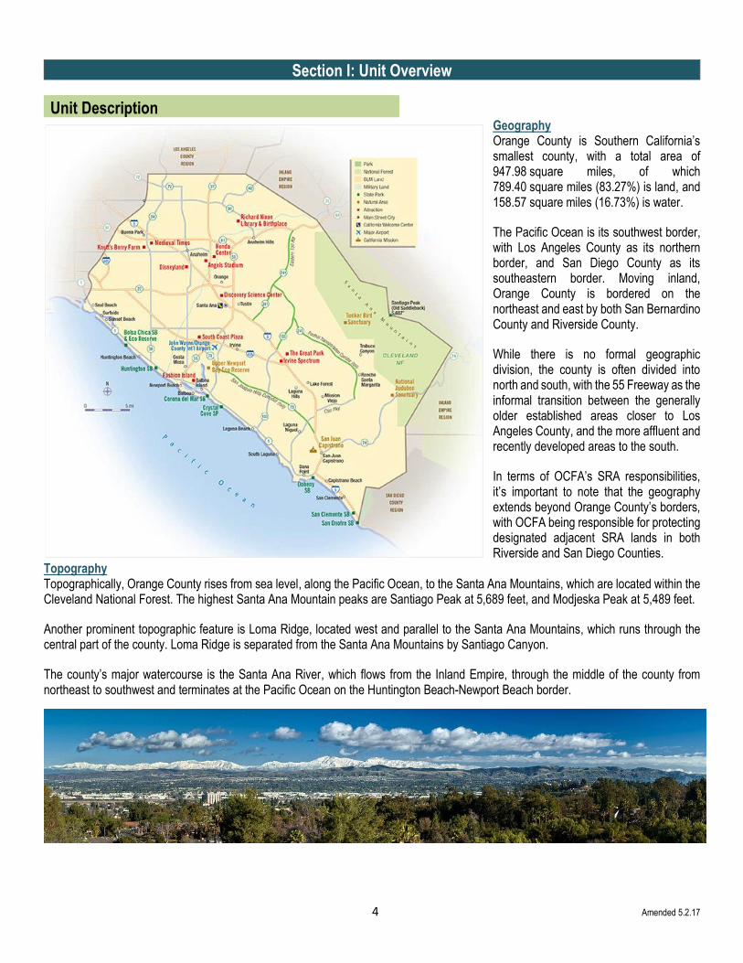
Unit Description
Geography Orange County is Southern California’s smallest county, with a total area of 947.98 square miles, of which 789.40 square miles (83.27%) is land, and 158.57 square miles (16.73%) is water.
The Pacific Ocean is its southwest border, with Los Angeles County as its northern border, and San Diego County as its southeastern border. Moving inland, Orange County is bordered on the northeast and east by both San Bernardino County and Riverside County.
While there is no formal geographic division, the county is often divided into north and south, with the 55 Freeway as the informal transition between the generally older established areas closer to Los Angeles County, and the more affluent and recently developed areas to the south.
In terms of OCFA’s SRA responsibilities, it’s important to note that the geography extends beyond Orange County’s borders, with OCFA being responsible for protecting designated adjacent SRA lands in both Riverside and San Diego Counties.
Topography Topographically, Orange County rises from sea level, along the Pacific Ocean, to the Santa Ana Mountains, which are located within the Cleveland National Forest. The highest Santa Ana Mountain peaks are Santiago Peak at 5,689 feet, and Modjeska Peak at 5,489 feet.
Another prominent topographic feature is Loma Ridge, located west and parallel to the Santa Ana Mountains, which runs through the central part of the county. Loma Ridge is separated from the Santa Ana Mountains by Santiago Canyon.
The county’s major watercourse is the Santa Ana River, which flows from the Inland Empire, through the middle of the county from northeast to southwest and terminates at the Pacific Ocean on the Huntington Beach-Newport Beach border.

5 Amended 6.30.16
Public Lands
Public lands within, or adjacent to, Orange County’s SRA lands play an important role in the management of natural resources, as well with pre-fire management planning, and include Camp Pendleton Marine Base, Cleveland National Forest, Chino Hills State Park, Crystal Cove State Park, plus Orange County Transportation Authority (OCTA) and Transportation Corridor Agency (TCA) lands.
Public Lands Map
Note: There are several other Federal, State and local government land holdings that do not have a role in this

6 Amended 5.8.18
Privately Managed Lands
Similarly, there are also privately owned and/or managed open space lands in, and near, the SRA that play an important role, which
include Audubon Starr Ranch, Irvine Ranch Conservancy, Natural Communities Coalition (formerly known as Nature Reserve of
Orange County), and Rancho Mission Viejo Land Trust.
Privately Owned/Managed Land Map

7 Amended 6.30.16
Population
Orange County has 3.18 million residents, who reside in 1.0 million housing units. Orange County also has the distinction of being the second most densely populated county in the state and includes 34 incorporated cities, plus 16 unincorporated areas. Santa Ana is the county seat.
According to the 2010 Census, compared to California overall, Orange County is relatively more educated, affluent and increasingly diverse.
• Median HH Income: OC $75.4K vs. CA $61.0K
• Bachelor’s Degree +: OC 36.8% vs. CA 30.7%
• Home Ownership: OC 58.7% vs. CA 55.3%
• MDU’s: OC 34.2% vs. CA 31.0%
• Foreign Born: OC 30.4% vs. CA 27.0%
• Non-English (spoken at home): OC 45.5% vs. CA 43.7%
Major Transportation Arteries
With so many people and limited public transportation, Orange County roadways are of critical importance in keeping the resident
population moving, along with the large daily influx of commuters from outside the county.
However, most of the major roads pass through wildfire prone SRA lands and open space areas, and are often the site of roadside
wildfire ignitions, including Interstate 5, CA 57, CA 74 (Ortega Highway), CA 91, and the 73 133 and 241 Toll Roads.
Population Density
Darker Shading = More Densely Populated

8 Amended 6.30.16
Vegetation Types Vegetation types dominating the open spaces are annual grasses, woodland, desert brush, riparian, coastal sage scrub and chaparral. The general condition of the vegetation covers a broad spectrum from healthy to decadent and from new growth to old growth. Approximately 60% of the wildland vegetation has experienced at least one catastrophic fire within the last decade. However, as drought conditions persist, the fuels have become increasingly hazardous.
Consequently, fuel moistures are measured at two locations monthly to help evaluate their potential as a wildfire risk factor. One location is in Black Star Canyon, in the northern part of the county, while the other location is in South County, near CA 74 (Ortega Highway).
Weather Like most of Southern California, Orange County is considered to have a Mediterranean climate, where precipitation occurs during the winter months and summers are typically hot and dry. The average daily temperature is 70 ˚F, with average annual rainfall ranging from 10-14 inches. Weather phenomena characteristic of Orange County, includes:
• Microclimate Conditions - Where temperatures can vary as much as 18°F from inland areas to the coast, with a temperature gradient of over one degree per mile.
• May Gray/June Gloom - Often brings morning overcast skies to the coastal cities that usually give way to sunny skies by noon, during the late spring and early summer.
• Santa Ana Winds - Per the National Weather Service (NWS), Santa Ana Winds are "strong down slope winds that blow through the mountain passes in Southern California”. They can easily exceed 40 miles per hour, are warm and dry, and can severely exacerbate brush or forest fires, especially under drought conditions.
OCFA uses 3 remote weather stations to help monitor weather conditions and the associated wildfire risk. Additionally, in late 2014, OCFA, in partnership with COAST and NOAA, was successful in implementing a third weather zone for Orange County. This has proven to be invaluable for OCFA, as well as for other private and public organizations, to help make more informed decisions regarding resource deployments, facility closures, and activity restrictions.

9 Amended 4.26.19
Unit Preparedness & Firefighting Capabilities
The Orange County Fire Authority The Orange County Fire Authority operates as a Joint Powers of Authority, and contracts with 24 of Orange County’s 34 incorporated cities to provide a full spectrum of fire protection services. Additionally, OCFA is contracted by the County of Orange to protect its 16 unincorporated communities, as well as Orange County Parks. CAL FIRE also contracts with OCFA to protect Orange County’s SRA lands, which include 2 State Parks, plus portions of the Cleveland National Forest Trabuco Ranger District.
OCFA is headquartered in Irvine, CA at the Regional Fire Operations Training Center (RFOTC), and has 79 fire stations, all of which are equipped with wildland firefighting capabilities, including 22 with specialized wildland apparatus.

10 Amended 4.26.19
OCFA Programs OCFA Apparatus
Air and Wildland Section • Helicopter program • Hand Crew Program • Pre-Fire Management • Wildland Resource Planner • Investigations (includes Fire Friends Arson Intervention
Program) Community Risk Reduction • Community Education • Wildland Pre-Fire Management • Prevention Field Services • Planning and Development Geographic Information Systems (GIS)
• Type I Engines – All with wildland capabilities • Type II Engines • Type III Engines • Type VI Engines with CAFS capabilities • Tactical Water Tenders • Support Water Tenders
Orange County Fire History Recent history illustrates that Orange County is prone to large scale wildfires in, and near the SRA, including the following:
Recent Wildfire History
• Oct. 1978: Soquel Fire (5,428 acres) • Sep. 1979: Paseo Fire (3,644 acres) • Oct. 1980: Owl Fire (18,332 acres) • Nov. 1980: Carbon Canyon Fire
(14,613 acres) • Nov. 1980: Indian Fire (28,408
acres) • Oct. 1982: Gypsum Fire (19,986
acres) • Sep. 1987: Silverado Fire (5,988
acres) • Sep. 1988: Ortega Fire (2,471 acres)
• Jul. 1989: Ortega Fire (8,170 acres) • Oct. 1989: Assist #108-Mateo Fire
(13,478 acres) • Jun. 1990: Carbon Canyon (6,664
acres) • Jul. 1990: Yorba (7,884 acres) • Oct. 1993: Laguna Fire
(14,337acres) • Oct. 1993: Ortega Fire (21,010
acres) • Oct. 1997: Baker Fire (4,835) • Aug. 1998: Santiago Canyon (7,760
acres)
• Feb. 2002: Green Fire (2,234 acres) • Feb. 2006: Sierra Peak (10,506
acres) • Mar. 2007: 241/Windy Ridge Fire
(2,036 acres) • Oct. 2007: Santiago Fire (28, 517
acres) • *Nov. 2008: Freeway Complex Fire
(30,305 acres) • **Sep. 2017: Canyon I Fire (2,662
acres) • Oct. 2017: Canyon II Fire (9,217
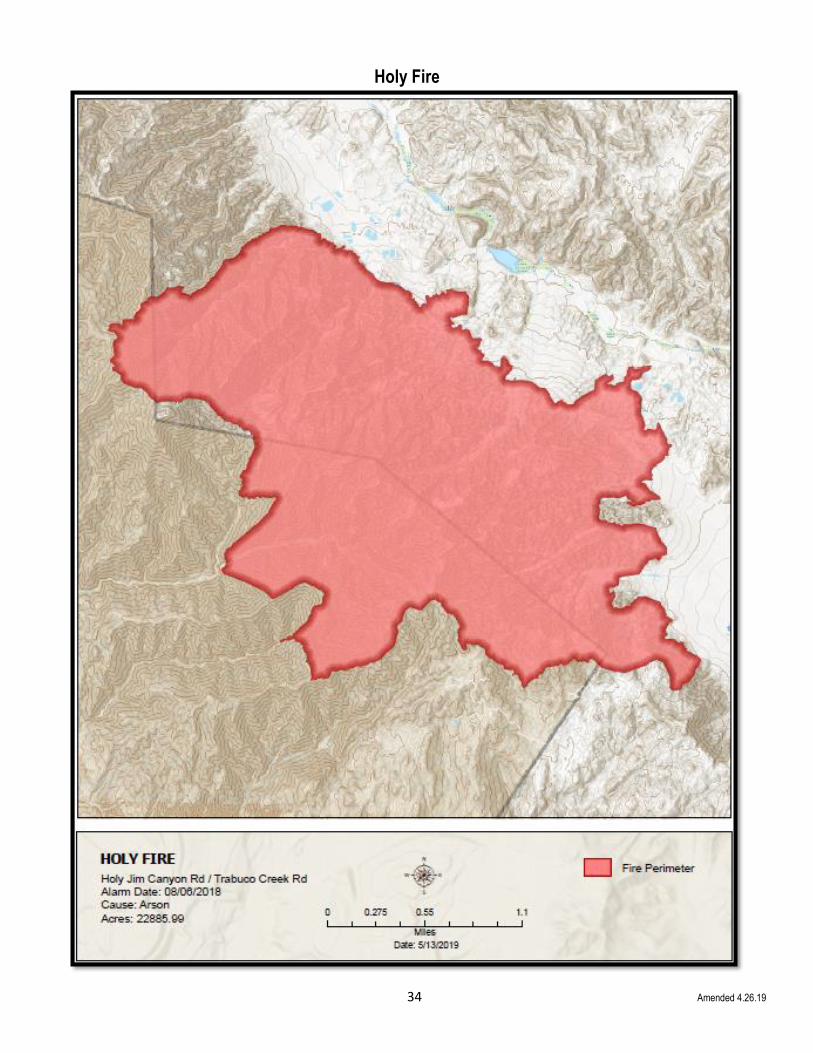
acres) • Aug. 2018: Holy Fire (22,885 acres)
*Notes: (1) The November 2008 Freeway Complex Fire started in Riverside County, but burned into Orange County
**(2) The September 2017 Canyon I Fire started in Anaheim, but burned into OCFA jurisdiction.

11 Amended 5.13.19
Orange County Fires - Perimeter Acreage History
It’s not unusual for Orange County’s wildfires to have perimeters in excess of 10,000 acres, with some having perimeters of up to 30,000 acres.

12 Amended 4.24.20
2019 Orange County Vegetation Fires

13 Amended 4.24.20
Ignitions OCFA’s Investigations Section attempts to determine the cause of all Orange County fires that are in, or are a threat to SRA areas, but for the vast majority, the cause remains Unknown/Unidentified or Miscellaneous. However, to combat roadside ignitions, which are of particular concern in Orange County, OCFA is partnering with COAST member organizations, including CalTrans, the Transportation Corridor Agency (TCA), and the Orange County Transportation Authority (OCTA) to develop preventive measures to better address this issue.
Over the past few years, as drought conditions persisted, the only definitive trend is that there are more fires, and a corresponding increase in the percentage of Unknown/Unidentified and Miscellaneous ignition causes.
Source: OFCA Fire Origin and Perimeter Data. Disclaimer: Prior Orange County coding practices have resulted in data inconsistencies with CFIRS and NFIRS. Efforts are underway to correct this issue.
Challenges In remote and rural areas of the county, firefighters are often faced with a limited water supply and lack of hydrant taps. Rural areas are characteristically outfitted with small diameter pipe water systems, which are inadequate for providing sustained firefighting flows. While not all these issues are within OCFA’s control, prevention efforts for the ones that are, such as road clearance, fuels reduction, defensible space inspections and resident education will continue to be incorporated into this plan.
Some of the most difficult fire protection problems encountered in the Wildland Urban Interface are:
• Multiple story, wood frame, high-density developments
• Large contiguous built up areas with combustible roofing materials
• Response times for emergency equipment
• Street structure, such as truck trails, non-surfaced private roads, and/or curvilinear roads, with dead-ends and narrow street widths
• Inadequate and unreliable water supply with poor hydrant distribution However, perhaps the most pressing problem overall is public apathy and unawareness regarding wildfire risks. The ongoing challenge will be for people to understand that surviving a wildfire may depend on their willingness to accept personal responsibility for protecting their homes, families and communities, by implementing proven preparedness and prevention strategies before fire occurs.
14 Amended 4.26.20
Section II: Collaboration
When this plan was originally developed in 2010, OCFA enlisted input from outside organizations (see Appendix H), including Bon Terra Consulting (restoration ecology), California State Parks, Habitat Restoration Services (HRS), the Fire Safe Council of East Orange County Canyons, Irvine Ranch Conservancy, Orange County Parks, Rancho Mission Viejo Ranch Operations & Land Trust, The Irvine Company Agricultural Operations and The City of Irvine. During that process, the following activities were identified as requiring collaborative efforts from both private and public sector agencies:
Collaborative Programs (Identified in 2010) Progress to Date (as of April 2020)
CWPP Management
• Develop and document partnership(s) with stakeholders to recognize and understand risks from wildland fire and hazardous fuels
• Develop and document strategies to mitigate risks from wildland fire and hazardous fuels
OCFA has continued to develop partnerships, as well as strategies, that will help reduce hazardous fuels and mitigate wildland fire risks. With the 2017 CWPP completion, some key projects listed in it are now being planned and implemented. For example, in 2018, the hand crew completed a hazardous fuel reduction project at Mason Park, on OC Parks land. This project not only increased fire safety to the nearby homes, but decreased invasive plant species in the park and opened habitat for native species. In addition, the CWPP is planned to be re-written in 2020/2021 to include additional cities and landowners.
Fire Hazard Mapping
• Develop a map of all wildland areas that will illustrate the locations of all assets at risk from wildland fire
In 2016, OCFA’s CRR/Special Operations Pre-Fire Management efforts and IT Sections launched a Wildland GIS App that contains FHSZ layers and various assets at risk. Information continues to be collected and updated. OCFA is working on a CALFIRE grant to acquire Normalized Difference Vegetation Index mapping of fuels within the SRA Threat Zone to gain better information regarding vegetation conditions and moistures as they change throughout the year.
Fuel Break Program
• Develop a fuel break system to identify logical and potential locations
• Construct new fuel breaks in strategic positions, clear existing old fuel breaks and provide a mechanism for periodic (at least annual) maintenance
Existing fuels breaks are routinely maintained and more have been added since 2010. Ongoing input from participating partners is coordinated for additional locations.
Fuel Reduction Program
• Have property owners, or agencies having jurisdiction, become more aware of hazardous fuels on their respective properties
• Have mechanisms in place to assist in the removal of hazardous fuels
OCFA conducts annual defensible space inspections on private and commercial properties in the SRA, and in other Very High and High Fire Hazard Severity Zones. Owners, land managers and residents are issued correction notices when hazardous conditions exist and are re-inspected to ensure compliance. Also, OCFA often assists in the removal of hazardous fuels on a project basis and helps with Chipper Days and other events to assist private residents in SRA and WUI areas.
Prescribed Fire Program
• Re-establish a prescribed fire program as a mechanism for mitigating risks from wildland fire and for hazardous fuel reduction
Prescribed fire has been an ongoing challenge in Orange County for many years, but recently, OCFA has been able to get the conversation started again, primarily with COAST organizations.
Road Maintenance
• Ensure annual maintenance is completed on all roads and trails prior to the wildland fire season
OCFA’s Crews & Heavy Equipment section are contracted to perform maintenance on SCE roads, most of which are also fire access roads. Other road and trail maintenance are done regularly as time allows.
Source: 2014 ORC Strategic Unit Fire Plan & OCFA Pre-Fire Management
Since 2010, in keeping with the original vision of this plan, collaborative efforts continue, and now regularly include ongoing dialogues and interactions, both within OCFA, and externally, with residents, cities and communities within OCFA’s jurisdiction, local fire safe councils, HOA’s, other fire agencies, COAST organizations, and with many others. Regular collaborators by category include:
15 Amended 4.26.20
• OCFA - Operations, GIS, Crews & Equipment, Wildland Pre-Fire Management, Planning & Development, and Corporate Communications
• Community - Residents, volunteers, HOA’s, cities and unincorporated communities
• Fire Safe Councils - North Tustin FSC, Fire Safe Council of East Orange County Canyons, Emerald Bay Community Association, and the Inter-Canyon League
• COAST - Refer to the COAST member list on the following page
COAST Background COAST Members
In an effort to facilitate a more comprehensive, and effective approach to addressing wildfire issues for Orange County, the County of Orange Area Safety Task Force (COAST) was formed in 2013. COAST members include large open space landowners and managers, city, county, state and federal government organizations, utilities, road agencies, OCFA, and other fire agencies, as well as others, all who have a vested interest in preventing wildfire ignitions and limiting the associated losses. Member organizations can influence policy and ensure progress is made.
Among other accomplishments, COAST can be credited with helping to institute a new NWS third weather zone for Orange County. Additionally, discussions with the transportation agencies are underway about possible barriers and/or treatments to help prevent roadside ignitions. Another current endeavor is working toward implementing HPWREN cameras for Orange County.
Furthermore, COAST has been instrumental in helping to champion the CWPP process, which is now complete and due to be updated in 2020/2021.
The ultimate goal of collaboratively developing a more comprehensive, and inclusive fire protection plan, through a CWPP, is to reduce the losses from wildfire (i.e. people, property, possessions, critical infrastructure and services, ecology, Threatened & Endangered Species, commerce, etc.) by helping to reduce ignitions and limit the impact, which in Orange County, requires a concentrated effort in, and around SRA and open space lands.
The CWPP: (1) Better identifies impactful, yet cost effective projects (2) Analyzes and prioritize them (3) Will help secure funding to complete them
Projects include, but are not limited to, planning, mapping, fuels reduction, vegetation management, structure hardening, roads hardening, infrastructure improvements, education, training and equipment purchases/upgrades.
County Organizations
• Orange County Parks (OC Parks)
• OCFA
• County of Orange
State Organizations
• CA Department of Fish & Wildlife
• CA State Parks (Chino Hills & Crystal Cove State Parks)
• CA Fish & Game, South Coast Region
Federal Agencies
• USFS Cleveland National Forest
• US Fish & Wildlife
• Camp Pendleton
Other Fire Agencies
• Anaheim Fire
• Laguna Beach Fire
• Newport Beach Fire
• Orange City Fire
• Brea/Fullerton
Transportation Agencies
• Cal Trans
• Orange County Transportation Authority (OCTA)
• Transportation Corridor Agency (TCA)
Utilities
• Southern California Edison (SCE)
• San Diego Gas & Electric (SDG&E)
• Irvine Ranch Water District (IRWD)
• Metropolitan Water District (MWD)
Large Land Managers
• Audubon Starr Ranch
• Irvine Ranch Conservancy (IRC)
• Natural Communities Coalition (formerly NROC)
• Rancho Mission Viejo Land Trust (RMV)
• The Wildlands Conservancy
Other Participants
• UC Irvine
• National Oceanic and Atmospheric Administration (NOAA)
• UC Riverside
• CAL FIRE
16 Amended 5.10.17
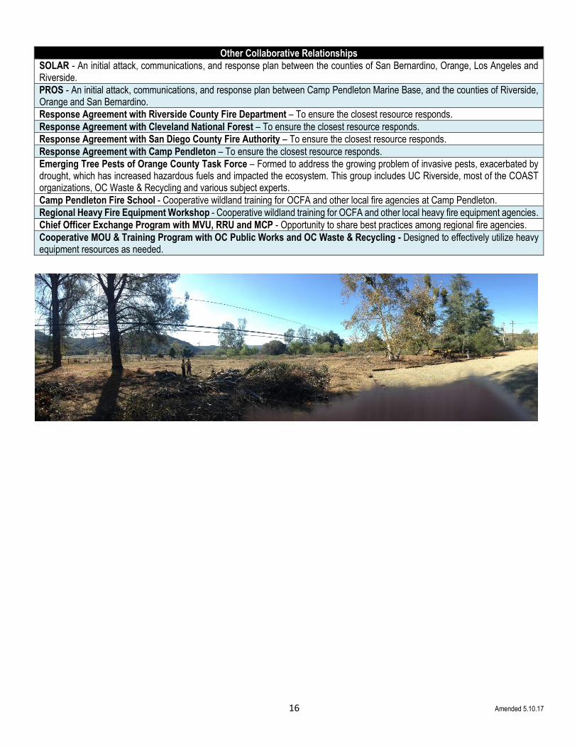
Other Collaborative Relationships
SOLAR - An initial attack, communications, and response plan between the counties of San Bernardino, Orange, Los Angeles and Riverside.
PROS - An initial attack, communications, and response plan between Camp Pendleton Marine Base, and the counties of Riverside, Orange and San Bernardino.
Response Agreement with Riverside County Fire Department – To ensure the closest resource responds.
Response Agreement with Cleveland National Forest – To ensure the closest resource responds.
Response Agreement with San Diego County Fire Authority – To ensure the closest resource responds.
Response Agreement with Camp Pendleton – To ensure the closest resource responds.
Emerging Tree Pests of Orange County Task Force – Formed to address the growing problem of invasive pests, exacerbated by drought, which has increased hazardous fuels and impacted the ecosystem. This group includes UC Riverside, most of the COAST organizations, OC Waste & Recycling and various subject experts.
Camp Pendleton Fire School - Cooperative wildland training for OCFA and other local fire agencies at Camp Pendleton.
Regional Heavy Fire Equipment Workshop - Cooperative wildland training for OCFA and other local heavy fire equipment agencies.
Chief Officer Exchange Program with MVU, RRU and MCP - Opportunity to share best practices among regional fire agencies.
Cooperative MOU & Training Program with OC Public Works and OC Waste & Recycling - Designed to effectively utilize heavy equipment resources as needed.

17 Amended 7.5.16
Section III: Values
(A) Values at Risk
CAL FIRE’s California’s Forest and Rangeland’s 2010 Assessment was developed to identify and address the State’s key wildfire risk issues pertaining to community water, ecosystem health, forest and range economics, infrastructure, recreation, open space and wildlife. These areas of concern are spatially categorized as “Priority Landscapes”. The 11 types of Priority Landscapes that were determined to be most applicable to Orange County are identified below, with graphic representations regarding where, and to what degree, each one is of concern:
Orange County’s Priority Landscapes
Priority Landscape 1: Population Growth & Development

18 Amended 7.5.16
Orange County’s Priority Landscapes (continued) Priority Landscape 2: Preventing Wildfire Threats to Maintain Ecosystem Health

19 Amended 7.5.16
Orange County’s Priority Landscapes (continued) Priority Landscape 3: Restoring Wildfire Impacted Areas to Maintain Ecosystem Health

20 Amended 7.5.16
Orange County’s Priority Landscapes (continued) Priority Landscape 4: Preventing Wildfire Threats to Community Safety

21 Amended 5.21.15
Orange County’s Priority Landscapes (Continued) Priority Landscape 5: Water Supply

22 Amended 7.5.16
Orange County’s Priority Landscapes (continued) Priority Landscape 6: Water Quality

23 Amended 7.5.16
Orange County’s Priority Landscapes (continued) Priority Landscape 7: Community Wildfire Planning

24 Amended 7.5.16
Orange County’s Priority Landscapes (continued) Priority Landscape 8: Conserving Green Infrastructure

25 Amended 7.5.16
Orange County’s Priority Landscapes (continued) Priority Landscape 9: Managing Green Infrastructure

26 Amended 7.26.16
Orange County’s Priority Landscapes (continued) Priority Landscape 10: Threats to Forest Carbon from Wildfire, Insect & Disease

27 Amended 7.5.16
Orange County’s Priority Landscapes (continued) Priority Landscape 11: Threats to Forest Carbon from Development

28 Amended 5.2.17
Based on these 11 Priority Landscapes, the following “values” (i.e. assets) at risk were identified as Orange County’s highest concern, and should be addressed first:
Ecosystem - (as threatened by localized development and landscape level development).
• Localized structure and landscape development, and its resulting ecological disruption or damage, can influence the impact of a severe fire event, both in terms of possibly contributing to more frequent ignitions, and how it can affect the localized development should fire strike. Additionally, altered fuel conditions can promote even further ecological damage (e.g. mortality within larger tree sizes, soil impacts, etc.)
Structures, Major Roads & Transmission Lines - (as threatened from wildfire).
• The value of housing, as it pertains to density, and other infrastructure, are particularly susceptible to damage/loss from exposure to wildfire.
• Power delivery and communications sites are also susceptible to extended loss of service due to fire. Even the simple interruption of these services is a public safety/public welfare issue, which is also the case for major roads.
Water Supply & Water Quality – (as threatened by wildfire, and the effects of wildfire, on soil surfaces, plus threats to and from localized development, watersheds and climate changes.)
• Watersheds can burn in the dry season and then discharge torrents of debris into downstream populated plains during severe storms in following wet seasons. Historically, California’s South Coastal Plain has suffered the worst effects of the flood-fire sequence because it has the greatest concentration of fire prone, high debris producing watersheds that discharge into populated areas. Impacts include damage to downstream values, such as homes, roads, debris basins, and other infrastructure.

29 Amended 4.20.20
(B) Communities at Risk
Expanding on the 2001 National Fire Plan that identified communities near federal lands that are at risk from wildfire, CAL FIRE developed an even more comprehensive list for California that went beyond the federal lands criteria. This list is now managed by the California Fire Alliance and includes 24 Orange County communities as “Nationally Recognized Communities at Risk”. Most are within OCFA’s jurisdiction, but a few are protected by other fire agencies, as indicated.
In addition, OCFA has identified several other communities as being at risk from wildfire, including:
• Emerald Bay
• Lake Forest
• Lemon Heights/North Tustin
• Santiago Canyon
• Tustin Heights
Beyond the previously listed Communities at Risk are a number of other high consequence values that require consideration, but are not included in this plan such as:
• Commerce: Various shopping, entertainment, business and restaurant locations
• Recreation: Various recreational venues (i.e. Irvine Lake, camp grounds, sports facilities, parks, beaches, etc.)
• Nature Preserves: Various ecological and habitat preserves (i.e. wetlands, tide pools, etc.)
• Historical Sites: Mission San Juan Capistrano, Richard Nixon Library, and numerous other historically significant places
• Military: Seal Beach Naval Weapons, Camp Pendleton, Los Alamitos Joint Forces Training Base, etc.
• Transportation: John Wayne Airport, and various railroads, harbors, bridges and roads, etc.
• Utilities: Communications infrastructure, oil and gas facilities, water and power facilities, including the San Onofre and UCI
nuclear facilities, etc.
• Educational Facilities: Universities (i.e. UCI, Cal State Fullerton, Chapman, etc.), community colleges, and K-12 facilities
Community Name Jurisdiction Federal Threat Federally Regulated
Aliso Viejo OCFA
Anaheim Non-OCFA
Brea Non-OCFA X
Coto de Caza OCFA X
Cowan Heights OCFA
Dana Point OCFA X
Irvine OCFA X
Laguna Beach Non-OCFA X
Laguna Hills OCFA X
Laguna Niguel OCFA
Laguna Woods OCFA
Mission Viejo OCFA
Modjeska OCFA X
Newport Beach Non-OCFA
Orange Non-OCFA
Rancho Santa Margarita OCFA X
San Clemente OCFA X
San Juan Capistrano OCFA
Silverado OCFA X
Trabuco Canyon OCFA X
Trabuco Highlands OCFA X X
Villa Park OCFA
Yorba Linda OCFA X
Nationally Recognized Communities At Risk

30 Amended 4.20.20
Section IV: Community Risk Reduction/Special Operations Pre-Fire Management Efforts
(A) Fire Prevention
As mentioned previously, Orange County is the 2nd most densely populated county in the state, with wildfire as its number one fire risk. Consequently, continued residential, commercial and industrial growth presents an ongoing challenge. In the Wildland Urban Interface, efforts to prevent ignitions and limit wildfire losses, led by OCFA’s fully staffed Community Risk Reduction/Special Operations Pre-Fire Management, which includes Wildland Resource Planning and Community Wildfire Mitigation Programs, hinge on the efforts for hardening structures and creating defensible space through a multi-faceted approach, sometimes referred to as the “4-E’s”, which includes Engineering, Enforcement, Education and Evaluation.
Engineering & Ignitions It’s interesting to note that much of Orange County has adopted regulations that are actually more stringent than California regulations. To engineer effective defensible space into the development process, Community Risk Reduction/Special Operations Pre-Fire Management uses proven vegetation management practices when reviewing and approving all landscaping and fuel modification zone plans. For structures, ignition prevention efforts start with OCFA’s Planning & Development section, which ensures that comprehensive pre-emergency planning has been done, and that fire protection measures are engineered into the design of both residential and commercial structures, for both new construction and remodels. Chapter 7-A building requirements are incorporated, as well as Title 24, Title 19, Title 14, PRC 4290 and PRC 4291, to identify and address potential wildfire hazards, and to help develop mitigation measures that will aid in making the structures more defensible.
Enforcement For existing structures, OCFA is actively involved in enforcing codes and ordinances, and conducts regular inspections to ensure a reasonable degree of fire protection exists in facilities and occupancies, and that they remain compliant with existing fire codes.
In terms of enforcing vegetation management guidelines, OCFA also conducts annual defensible space inspections for homes and structures within the Very High and High Fire Severity Zones to ensure they remain in compliance. The same is true for Fuel Modification Zones and Homeowners Association properties, which are also inspected. Similarly, OCFA also inspects power poles annually to help prevent ignitions by ensuring that adequate vegetation clearance exists and to help provide to provide defensible space.
Education OCFA staff participates in ongoing training programs, designed to ensure that they stay current with codes, regulations, current issues and best practices. In addition, OCFA champions the “Ready, Set, Go!” message to promote wildfire education and conduct outreach programs. Based on the premise that during a major wildfire, there may not be enough firefighting resources to protect every home, “Ready, Set, Go!” encourages residents to take personal responsibility for preparing their property and family to become part of a solution for the problem of increasing fire losses during wildfires. Special emphasis is focused on ember intrusion and the actions that homeowners can take to lower their risk, such as retrofitting homes with ignition resistive features, and creating defensible space around their property, such as with trimming and regular maintenance, and planting with ignition resistive plants. This is of particular importance for residents in Wildland Urban Interface (WUI) areas, where wildfire survivability relies more heavily on the landowner’s personal initiative to take measures to protect his or her own life and property. Additional information regarding the preparation of family emergency plans and kits, contact phone numbers, and evacuation plans are also discussed.
Additionally, OCFA offers free home consultations that focus on home hardening and improving defensible space and conducts community presentations all year long to various groups, such as HOAs, schools, clubs, etc. on wildfire preparedness and a variety of safety topics. All information is available electronically from OCFA.org/RSG and related links, as well as from printed materials.
Other actions that contribute to the education and safety of the communities include:
• Developing and testing marketing initiatives, plus education and outreach materials, to obtain intended behavioral change results
• Continued relationship building with local partners and agencies to target and distribute information
• Encouraging community participation with stakeholder groups, and supporting fire safe council formation
• Mapping and risk ranking of communities affected by WUI issues
• Development of an interactive, GIS-based computer model that provides risk information to the public

31 Amended 4.20.20
Additionally, in 2013, OCFA, in conjunction with other key emergency related agencies, conducted the first ever Community Evacuation Drill for Cowan Heights, a community with limited access and at risk from wildland fire. Not only was this exercise designed to help educate and prepare residents for an actual emergency, but also to help participating organizations fine tune their response plans. It proved to be a valuable learning and outreach experience that may be replicated in other vulnerable communities in the future.
Evaluation OCFA works to identify the need for amendments when issues arise and collaborates with regulatory agencies to improve regulations that will result in maximum effectiveness with minimum environmental impact. Additionally, mapping hazardous fire zone areas is also done to aid in the evaluation and planning process.
(B) Vegetation Management
Vegetation management remains at the forefront of fire prevention efforts in Orange County. As watering is increasingly rationed, landscaping and previously irrigated fuel modification zones are drying up, exacerbating the already hazardous conditions. In addition, invasive plant species are proliferating, and drought stressed trees have become more vulnerable to destructive pests, such as the polyphagous shot hole borer and the gold spotted oak borer, which are killing trees, and adding to the fire danger. Consequently, to adapt, OCFA is encouraging a shift towards landscaping and replanting with native species, which are more drought tolerant and fire resistive.
When they are not fighting fires, OCFA’s Hand Crew and Heavy Equipment Operators routinely work on hazardous fuels reduction projects for a variety of organizations, including Southern California Edison, OC Parks, State Parks and large landowners/managers. They also assist with targeted community initiatives, such as Chipper Days, sponsored by local fire safe councils, etc.
OCFA’s Community Risk Reduction/Special Operations Pre-Fire Management section works with developers, open space partners, and homeowner associations to engineer and re-engineer fuel modification zones and landscaping that reflects the new reality of less water, and the need to return to a native species plant palate to help reduce hazardous vegetation. They also conduct annual defensible space inspections in high risk areas help ensure vegetation management guidelines are maintained.
Residents can refer to several online and printed resources, including OCFA.org for tips on fire resistive plants, plus proper spacing and maintenance.
Additionally, to address the problem of roadside and contractor-caused ignitions, typically due to unsafe equipment use practices in wildfire risk areas, OCFA has been working with large landowners/managers, landscapers and other stakeholders to help educate and enforce equipment-use guidelines in wildfire risk areas. Efforts have included training, infographic decals, posters flyers, and other messaging targeted at contractors, landscapers, HOA’s and others.
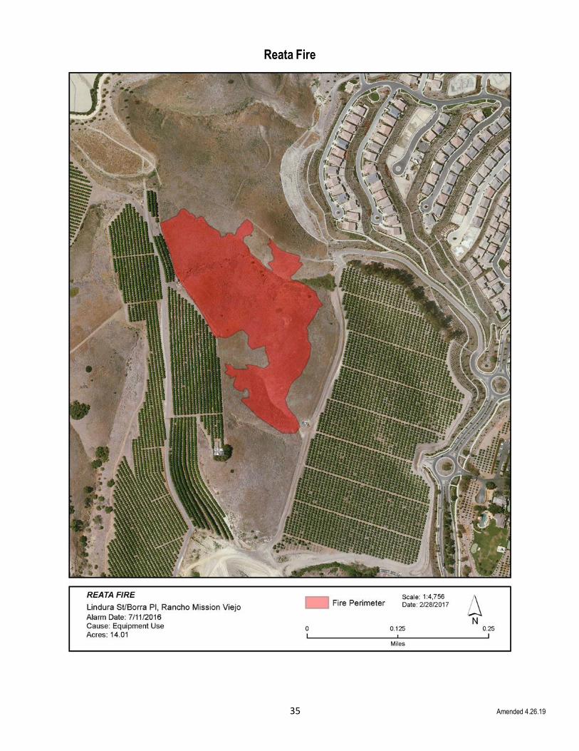
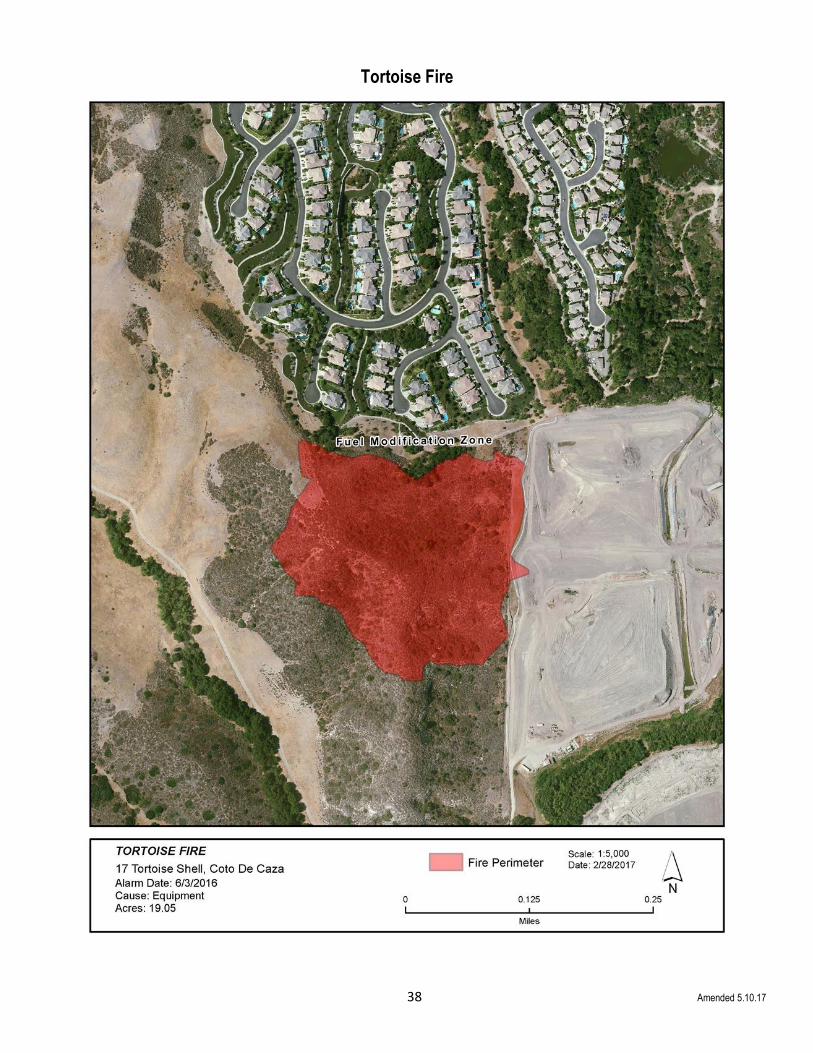
When put to the test, OCFA’s focus on vegetation management and defensible space has repeatedly paid off, as evidenced with the perimeter maps of four recent Orange County fires, the Reata, San Juan, Trabuco and Tortoise fires, that were held in check due to these best pre-fire management practices:

32 Amended 4.26.19
Aliso Fire

33 Amended 4.26.19
Canyon II Fire
34 Amended 4.26.19
Holy Fire
35 Amended 4.26.19
Reata Fire

36 Amended 5.4.17
San Juan Fire

37 Amended 5.4.17
Trabuco Fire
38 Amended 5.10.17
Tortoise Fire
39 Amended 4.26.19
Section V: Community Risk Reduction/Special Operations Pre-Fire Management Tactics
The Orange County Fire Authority (OCFA) has a wide variety of programs and plans that have been, or are in the process of being, developed to help mitigate wildfire ignitions and limit the losses for communities in, and adjacent to, the county’s SRA and open space lands. The plans and programs are either tactical or strategic in nature, are typically developed collaboratively with OCFA’s Community Risk Reduction/Special Operations Pre-Fire Management section and/or Emergency Planning and Coordination (EPAC) sections and are available upon request from EPAC. Examples include:
• OCFA Tactical Fire Suppression Plans - Tactical response plans
• Outside Organization Fire Plans - Provided to OCFA by outside organizations, and often developed with OCFA’s input
• County of Orange Area Safety Task Force (COAST) Plans - Proposed by COAST member organizations, which are now
housed in the CWPP, and usually include input from OCFA
• OCFA Division/Battalion Recommendations - Generated by annual battalion inspections of 1st due areas near SRA and
open space lands
Tactical Fire Suppression Plans
OCFA developed these plans to guide fire and law enforcement agencies during major wildfire occurrence in large areas of intermingled open spaces and densely populated residential and commercial developments that lie within unincorporated and incorporated cities. Within the plans, sections identify the needs for residents to evacuate, and the safest means of evacuations and potential rendezvous sites. OCFA has individual plans for the following areas:
San Clemente San Juan Capistrano
Rancho Carrillo El Cariso
Caspers Park Rancho Mission Viejo
Laguna Beach Laguna Niguel
Ladera Ranch Coto de Caza and Wagon Wheel
Trabuco Canyon Robinson Ranch
Dove Canyon Portola Hills
Los Alisos-Mission Viejo Foothill Ranch
Modjeska Canyon Silverado Canyon
Baker Canyon Williams Canyon
Laguna Hills Portola Hills
Shady Canyon-Quail Hill Turtle Rock-Turtle Ridge
Newport Back Bay Buck Gully-Newport Coast
Cowan and Lemon Heights East Orange
Anaheim Hills Yorba Linda
Carbon Canyon Brea-Tonner Canyon
Portola-Irvine Las Flores
Aliso Viejo
Outside Organization Fire Plans
Developed by outside agencies, with technical assistance from OCFA. Plans are available upon request from each organization. Examples include:
• Natural Communities Coalition (formerly known as NROC) Tactical Fire Suppression Plan and the NCC Strategic Plan: The Tactical Plan addresses pre-suppression, suppression and post-suppression tactics. The suppression tactics identify desired actions and locations, while the post-suppression tactics identify the actions and responsibilities for fire suppression repair. The Strategic Plan is near completion, noting that NCC hired a consultant to work with OCFA and all stakeholders to complete the plan. This plan is the conduit to discuss and develop pre-suppression and prevention activities to reduce the loss of life, property, environment and suppression costs.

40 Amended 5.2.17
• The Southern Sub-Regional Wildland Fire Management Plan – Rancho Mission Viejo: Developed by a consultant firm for the Rancho Mission Viejo Land Trust, it’s designed to manage the natural resources of the ranch lands of Rancho Mission Viejo. OCFA, California Department of Fish and Game, U.S. Fish and Wildlife, the RMV Land Trust and a variety of other regulatory agencies were involved in the development. This plan addresses suppression tactics by identifying desired actions and locations, plus post-suppression tactics for actions and responsibilities for fire suppression repair. This plan is the conduit to discuss and develop pre-suppression and prevention activities to reduce the loss of life, property, environment and suppression costs.
• The Irvine Ranch Conservancy Wildland Fire Ignition Reduction Strategy: A collaborative effort between the Irvine Ranch Conservancy (IRC) and OCFA, this plan focuses on actions that will reduce the probability of wildland fire ignitions, particularly during Santa Ana Wind conditions. The plan highlights five (5) major action areas: Fire Watch Network, Fire-Hardening Roadways, Power line Safety, Wildland Access and Urban-Wildland Edge. Once again, this plan is the conduit to discuss and develop pre-suppression and prevention activities to reduce the loss of life, property, environment and suppression costs. However, emphasis on ignition reduction for environmental concerns is the highest priority.
• The Cowan Heights – Peters Canyon Project: This recently completed project was a collaborative effort between Orange County Public Works, Orange County Fire Authority and Orange County Parks and Recreation. The intended result was to reduce hazardous fuels to a minimum of 50% of the current available hazardous fuels (responsible agency – OCFA) and the restoration of the Lower San Diego Creek riparian area (responsible agency – OC Public Works). OCFA conducted outreach and education activities on the necessities of vegetation clearance and maintenance, plus home improvements that will add to survivability during a wildfire.
CWPP
As part of the CWPP development process, OCFA, along with partner agencies, developed a library of projects, which are categorized as follows:
• Ignition Prevention Action Plan
• Communication, Education & Awareness
• Fuel Management on Public & Large-Scale Private Lands
• Firefighting & Mitigation
• Planning
• Structure Survivability & Defensible Space
Initiatives in this library will be implemented as funding becomes available, and as a dynamic document, projects will be added and updated as necessary. These projects continue to build on the multi-faceted approach to developing, expanding and maintaining initiatives primarily designed to help prevent ignitions and prevent fire spread and to improve structure survivability. Limiting loss, whether it’s life, property or habitat is the ultimate goal. Projects will range from planning and vegetation management treatments, to new technologies and public education and outreach. Projects are discussed in further detail in the attached CWPP, but examples include:
• Remote Surveillance Expansion (i.e. Cameras, Fire Watch, HOA’s, etc.)
• Mapping of Fuel Loads, Invasive Species and Tree Mortality
• Comprehensive Road Ignition Program
• Collaborative Partner’s Joint Messaging
• Multi-Agency Training Programs

41 Amended 4.20.20
OCFA Division/Battalion Recommendations
Each year, the OCFA Divisions and Battalions that include SRA and open space areas evaluate their territories and make recommendations for pre-fire management projects to help reduce the fire risk. Typically, the projects are vegetation management, or roads and access related. Below are each Battalion’s suggested projects:
Pertinent to all OCFA Battalions:
Over the past few years, Orange County has seen a significant increase in the amount of Invasive Shot Hole Borers (ISHB), which are
killing thousands of trees within the SRA, open spaces, and the urban landscape. The death of these trees has created not only
millions of dollars in damages and significant loss socially, economically, and environmentally, but also created a significant fire
potential. ISHB, whether it be the Kuroshio or Polyphagous Shot Hole Borer or the Gold Spotted Oak Borer, either exists within all
Battalions in Orange County, or it will soon be spread to these Battalions due to the rapid reproduction and spread of these insects.
OCFA holds a bi-monthly “Emerging Tree Pest of Orange County Task Force” meeting, attended by key stakeholders, where issues
are identified, discussed, and potential control options are identified through the work that the University of California Cooperative
Extension is conducting. However, control options, such as spray treatments or tree removal, are expensive and not fully tested. More
information can be found at pshb.org and gsob.org.
It is important in all Divisions and Battalions to ensure annual maintenance is completed on all dirt roads and trails prior to the wildland
fire season. In some cases, OCFA’s Crews and Heavy Equipment section are contracted to perform maintenance on SCE roads, most
of which are also fire and emergency access roads. Other road and trail maintenance are done regularly as time allows. Using the
OCFA handcrews to brush these roads creates a shaded fuel break that allows for safer emergency ingress and egress for crews and
equipment during wildland fires and other emergencies, such as remote rescues.
42 Amended 5.10.18
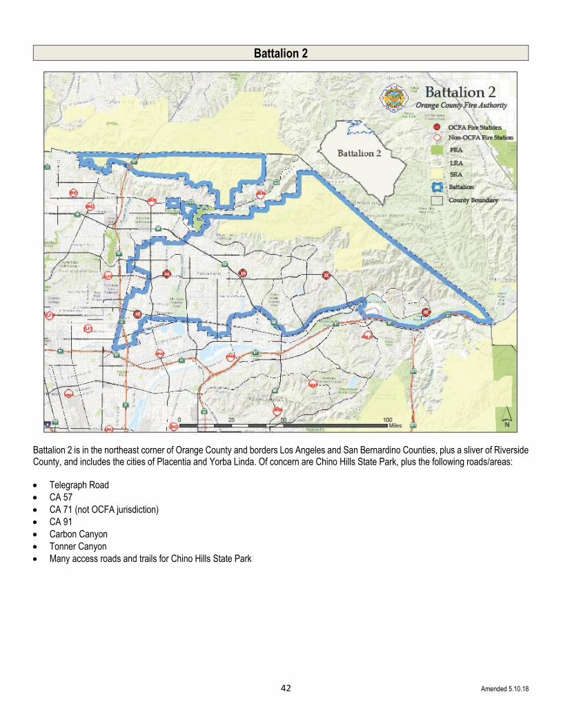
Battalion 2
Battalion 2 is in the northeast corner of Orange County and borders Los Angeles and San Bernardino Counties, plus a sliver of Riverside County, and includes the cities of Placentia and Yorba Linda. Of concern are Chino Hills State Park, plus the following roads/areas:
• Telegraph Road
• CA 57
• CA 71 (not OCFA jurisdiction)
• CA 91
• Carbon Canyon
• Tonner Canyon
• Many access roads and trails for Chino Hills State Park

43 Amended 5.8.18
Battalion 2 (Continued)
Telegraph Rd & Chino Hills State Park Nature Center
Hazard - Natural vegetation throughout canyon; power lines along the east end of the North Canyon
Potential -Yorba Linda homes along the South Ridge and the Daimler Water Plant & Pump Station are at risk
Suggested Mitigation - Improve / reconstruct North Ridge Trail to re-establish access to Chino Hills State Park Visitor Center area. Also, minor soft limb trimming is needed for overhead clearance; improve Diemer Trail for access from Telegraph Canyon
Lambert - 57-Carbon Canyon-71/Tonner North & South
Hazard - Natural vegetation; power lines
Potential - Sleepy Hollow is problematic in a mega-fire scenario due to density, no hardening, and tight access (not OCFA jurisdiction, but probable OCFA involvement)
Suggested Mitigation - Sleepy Hollow early evacuation is a must; brush back county roads; construct additional safety zones on existing roads
Hollydale Mobile Home Estates
Hazard – Vegetation around community
Potential - High volume of structural loss
Suggested Mitigation - Needs brush clearance and fuel modification around community
Brush Canyon (Single Track) Road
Hazard - Access problem; vegetation
Potential - Loss of existing fire break
Suggested Mitigation - Improve/maintain existing ingress and egress
Slaughter Canyon Road (from Bane Canyon)
Hazard - Chino Hills State Park is overgrown/impassable
Potential - Loss of existing road/fire break
Suggested Mitigation – Maintain and improve existing road/fuel break
Scully Ridge (lower portion from Lower Aliso Road)
Hazard - Erosion; vegetation
Potential - Loss of fire break and access to Chino Hills State Park if erosion continues
Suggested Mitigation - Road improvement/maintenance; vegetation clearance
Wire Springs Spur Trail
Hazard - Access; vegetation
Potential - Loss of control line if vegetation
growth continues
Suggested Mitigation - Maintenance; vegetation clearance
Telephone Line Road
Hazard - Access; vegetation
Potential - Loss of fire break and access to Soquel Canyon
Suggested Mitigation - Improve road; clear vegetation
Telephone Line “Spur Road”
Hazard - Access; vegetation
Potential - Loss of fire break and access to Carbon Ridge
Suggested Mitigation - Improve road; clear vegetation
It was noted that while the Casino Ridge Road area has high value homes, more are scheduled to be built in the near future, which will add to the Values-At-Risk.

44 Amended 5.8.18
Battalion 3 - Southern
Battalion 3: Southern - Borders Riverside County and encompasses the communities of Villa Park, Tustin, Cowan/Lemon Heights, and the canyon areas, including:
• Silverado Canyon
• Williams Canyon
• Baker Canyon
• Limestone Canyon
• Loma Ridge
Major roads that pass through or near the SRA include the 241 and 261 Toll Roads and Santiago Canyon Road.
45 Amended 4.20.20
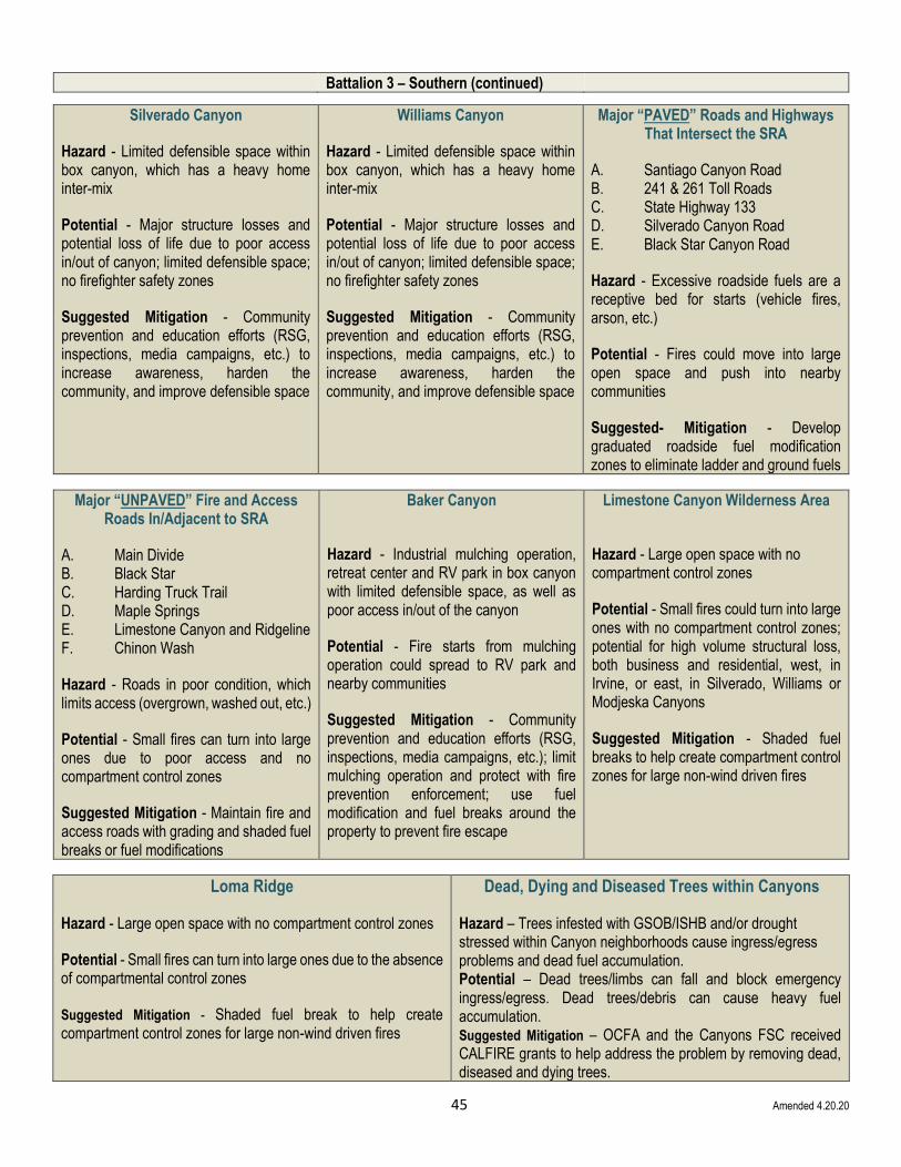
Battalion 3 – Southern (continued)
Silverado Canyon
Hazard - Limited defensible space within box canyon, which has a heavy home inter-mix
Potential - Major structure losses and potential loss of life due to poor access in/out of canyon; limited defensible space; no firefighter safety zones
Suggested Mitigation - Community prevention and education efforts (RSG, inspections, media campaigns, etc.) to increase awareness, harden the community, and improve defensible space
Williams Canyon
Hazard - Limited defensible space within box canyon, which has a heavy home inter-mix
Potential - Major structure losses and potential loss of life due to poor access in/out of canyon; limited defensible space; no firefighter safety zones
Suggested Mitigation - Community prevention and education efforts (RSG, inspections, media campaigns, etc.) to increase awareness, harden the community, and improve defensible space
Major “PAVED” Roads and Highways That Intersect the SRA
A. Santiago Canyon Road B. 241 & 261 Toll Roads C. State Highway 133 D. Silverado Canyon Road E. Black Star Canyon Road
Hazard - Excessive roadside fuels are a receptive bed for starts (vehicle fires, arson, etc.)
Potential - Fires could move into large open space and push into nearby communities
Suggested- Mitigation - Develop graduated roadside fuel modification zones to eliminate ladder and ground fuels
Major “UNPAVED” Fire and Access Roads In/Adjacent to SRA
A. Main Divide B. Black Star C. Harding Truck Trail D. Maple Springs E. Limestone Canyon and Ridgeline F. Chinon Wash
Hazard - Roads in poor condition, which limits access (overgrown, washed out, etc.)
Potential - Small fires can turn into large ones due to poor access and no compartment control zones
Suggested Mitigation - Maintain fire and access roads with grading and shaded fuel breaks or fuel modifications
Baker Canyon
Hazard - Industrial mulching operation, retreat center and RV park in box canyon with limited defensible space, as well as poor access in/out of the canyon
Potential - Fire starts from mulching operation could spread to RV park and nearby communities
Suggested Mitigation - Community prevention and education efforts (RSG, inspections, media campaigns, etc.); limit mulching operation and protect with fire prevention enforcement; use fuel modification and fuel breaks around the property to prevent fire escape
Limestone Canyon Wilderness Area
Hazard - Large open space with no compartment control zones
Potential - Small fires could turn into large ones with no compartment control zones; potential for high volume structural loss, both business and residential, west, in Irvine, or east, in Silverado, Williams or Modjeska Canyons
Suggested Mitigation - Shaded fuel breaks to help create compartment control zones for large non-wind driven fires
Loma Ridge
Hazard - Large open space with no compartment control zones
Potential - Small fires can turn into large ones due to the absence of compartmental control zones
Suggested Mitigation - Shaded fuel break to help create compartment control zones for large non-wind driven fires
Dead, Dying and Diseased Trees within Canyons
Hazard – Trees infested with GSOB/ISHB and/or drought stressed within Canyon neighborhoods cause ingress/egress problems and dead fuel accumulation. Potential – Dead trees/limbs can fall and block emergency ingress/egress. Dead trees/debris can cause heavy fuel accumulation. Suggested Mitigation – OCFA and the Canyons FSC received CALFIRE grants to help address the problem by removing dead, diseased and dying trees.
46 Amended 5.18.18
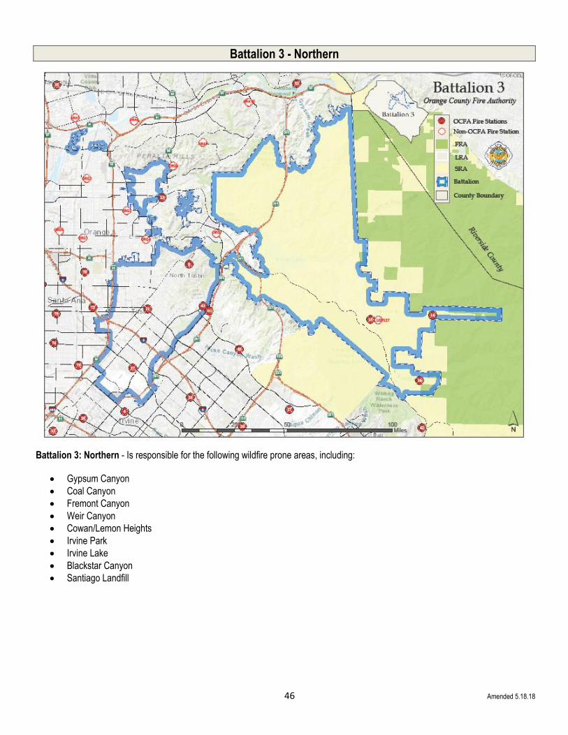
Battalion 3 - Northern
Battalion 3: Northern - Is responsible for the following wildfire prone areas, including:
• Gypsum Canyon
• Coal Canyon
• Fremont Canyon
• Weir Canyon
• Cowan/Lemon Heights
• Irvine Park
• Irvine Lake
• Blackstar Canyon
• Santiago Landfill

47 Amended 5.8.18
Battalion 3 – Northern (continued)
East/Corona South (Sierra Peak, Gypsum Canyon, Coal Canyon,
Fremont Canyon)
Hazard - Mixed fuel types in heavy concentration; extreme terrain; high voltage transmission lines
Potential - Extreme fire behavior; rapid rates of spread; unchecked fire entering the Wildland-Urban-Interface areas in the cities of Orange, Anaheim and unincorporated North Tustin
Suggested Mitigation - Update all plans, both Pre-Fire and Suppression, to reflect current fuel conditions; continued communication with Federal partners regarding conditions and plans for Forest Service lands
South/Orange/Tustin (Cowan Heights, Lemon Heights, Panorama Hill, Weir
Canyon, Irvine Park)
Hazard - Limited defensible spaces; dense older home construction in the Wildland-Urban-Interface and SRA
Potential - Major structure losses; potential loss of life due to poor access/egress in canyon and hillside areas; limited or no defensible space; limited firefighter safety zones
Suggested Mitigation - Community prevention and education efforts (RSG, inspections, media campaigns, etc.) to increase awareness, harden the community, and improve defensible space; update outside agency agreements, training and fire plans
East (Blackstar Canyon, Fremont Canyon, Irvine Lake, Santiago Landfill)
Hazard - Excessive roadside fuels are a receptive bed for starts (vehicle fires, arson, etc.); fuels consumed in 2006 Sierra Fire are re-established; increased access to the public may result in increased fire activity
Potential - Fires could move into the large open space and threaten nearby communities with the potential for a large volume of structure loss
Suggested Mitigation - Develop graduated roadside fuel modifications; maintenance of access roads; update fire plans and outside agency agreements
Orange/Tustin - (Cities of Orange - east side, Villa Park, Anaheim and
Unincorporated - Orange Park Acres)
Hazard - Overgrown vegetation, both ornamental and natural; older residential construction; ingress/egress issues for fire apparatus, as well as residents; dense Wildland-Urban-Interface mix
Potential - Small fires can turn into large ones with poor access and no compartment control zones
Suggested Mitigation - Maintain fire and access roads with grading and fuel modifications; update fire plans and outside agency agreements

48
Battalion 4
Battalion 4 - This southern Orange County battalion’s boundaries include the communities of Laguna Niguel, Laguna Hills, Laguna Woods, Lake Forest, Aliso Viejo and Emerald Bay. In addition to the 73 Toll Roads and 405 and 5 freeways, primary areas of concern include:
• Laguna Coast Wilderness Park
• Aliso Canyon Wilderness Park
• Wood Canyon Wilderness Park

49 Amended 5.8.18
Battalion 4 (continued)
Laguna Coast Wilderness Park (Aliso Viejo)
Hazard - No fuel breaks between Laguna Coast Wilderness Park and City of Aliso Viejo
Potential - Significant structure loss in Aliso Viejo
Suggested Mitigation - Construction of fuel breaks; improve fire breaks; brush back vegetation
Laguna Coast Wilderness Park (Laguna Woods)
Hazard - No fuel breaks between Laguna Coast Wilderness Park and City of Laguna Woods
Potential - Significant structure loss in Laguna Woods
Suggested Mitigation - Construction of fuel breaks; improve fire breaks; brush back vegetation
Aliso & Wood Canyons Wilderness Parks (Top of The World)
Hazard - No fuel breaks between Aliso and Wood Canyons Wilderness Parks and City of Laguna Beach (Top of the World)
Potential - Significant structure loss in Top of The World
Suggested Mitigation - Construction of fuel breaks; improve fire breaks; brush back vegetation
Aliso and Wood Canyons Wilderness Parks (South Laguna)
Hazard - No fuel breaks between Aliso and Wood Canyons Wilderness Parks and City of Laguna Beach (South Laguna)
Potential - Significant structure loss in South Laguna
Suggested Mitigation - Construction of fuel breaks; improve fire breaks; brush back vegetation
Aliso and Wood Canyons Wilderness Parks (Laguna Canyon)
Hazard - No fuel breaks between Aliso and Wood Canyons Wilderness Parks and City of Laguna Beach (Laguna Canyon)
Potential - Significant structure loss in Laguna Canyon
Suggested Mitigation - Construction of fuel breaks; improve fire breaks; brush back vegetation
Aliso and Wood Canyons Wilderness Parks (Laguna Niguel)
Hazard - No fuel breaks between Aliso and Wood Canyons Wilderness Parks and City of Laguna Niguel
Potential - Significant structure loss in Laguna Niguel
Suggested Mitigation - Construction of fuel breaks; improve fire breaks; brush back vegetation
Aliso & Wood Canyons Wilderness Parks (Aliso Viejo)
Hazard - No fuel breaks between the Aliso and Wood Canyons Wilderness Parks and Aliso Viejo
Potential - Significant structure loss in Aliso Viejo
Suggested Mitigation – construct/improve fuel breaks; brush back vegetation
Laguna Coast Wilderness Park (Newport Coast)
Hazard - No fuel breaks between Laguna Coast Wilderness Park and the City of Newport Beach (Newport Coast)
Potential - Significant structure loss in Newport Coast
Suggested Mitigation - Construction of fuel breaks; improve fire breaks; brush back vegetation
Laguna Coast Wilderness Park (Emerald Bay)
Hazard - No fuel breaks between Laguna Coast Wilderness Park and the residential area of County-Unincorporated Emerald Bay
Potential - Significant structure loss in Emerald Bay
Suggested Mitigation - Construction of fuel breaks; improve fire breaks; brush back vegetation

50 Amended 5.8.18
Battalion 4 (continued)
Crystal Cove State Park (Newport Coast)
Hazard - No fuel breaks between the Crystal Cove State Park and the City of Newport Beach (Newport Coast)
Potential - Significant structure loss in Newport Coast
Suggested Mitigation - Construction of fuel breaks; improve fire breaks; brush back vegetation
Crystal Cove State Park (Laguna Beach)
Hazard - No fuel breaks between the Crystal Cove State Park and the City of Laguna Beach
Potential - Significant structure loss in Laguna Beach
Suggested Mitigation - Construction of fuel breaks, improve fire breaks and brush back vegetation
Crystal Cove State Park (Emerald Bay)
Hazard - No fuel breaks between Crystal Cove State Park and the residential area of County-Unincorporated, Emerald Bay
Potential - Significant structure loss in Emerald Bay
Suggested Mitigation - Construction of fuel breaks, improve fire breaks and brush back vegetation
Roadside Ignitions (73, 133 7 241 Toll Roads)
Hazard - Roadside ignitions along the 73, 133 and 241 Toll Roads
Potential - Wind driven wildfire /Santa Ana Winds can threaten nearby communities including Irvine, Lake Forest, Mission Viejo, Laguna Beach, Laguna Niguel, Aliso Viejo and Rancho Santa Margarita
Suggested Mitigation – Roadside hardening

51 Amended 5.8.18
Battalion 4/5 Border
Of special note, on the border of Battalions 4 and 5 is Laguna Coast Wilderness Park, where the following areas of concern exist:
Laguna Coast Wilderness Park (Laguna Beach & Canyon)
Hazard - No fuel breaks between the
Laguna Coast Wilderness Park and City of Laguna Beach and Laguna Canyon
Potential - Significant structure loss in Laguna Canyon
Suggested Mitigation - Construction of fuel breaks; improve fire breaks; brush back vegetation
Laguna Coast Wilderness Park (North Laguna)
Hazard - No fuel breaks between the Laguna Coast Wilderness Park and City of Laguna Beach (North Laguna)
Potential - Significant structure loss in North Laguna Canyon
Suggested Mitigation - Construction of fuel breaks; improve fire breaks; brush back vegetation
Laguna Coast Wilderness Park (Top of The World)
Hazard - No fuel breaks between the Laguna Coast Wilderness Park and City of Laguna Beach (Top of The World)
Potential - Significant structure loss in Top of The World
Suggested Mitigation - Construction of fuel breaks; improve fire breaks; brush back vegetation

52 Amended 5.8.18
Battalion 5
Battalion 5 - The 73, 133 and 241 Toll Roads, plus Jamboree and Portola Pkwy are the major paved roads for this battalion, which encompasses the community of Irvine, including UC Irvine and John Wayne Airport, plus a sliver of the City of Lake Forest. Areas of concern include:
• Laguna Coast Wilderness Park
• Bee Canyon/Bowerman Landfill
• Roads

53 Amended 5.8.18
Battalion 5 (continued)
Laguna Coast Wilderness Park (Shady Canyon)
Hazard - No fuel breaks between Laguna Coast Wilderness Park and the City of Irvine (Shady Canyon)
Potential - Significant structure loss in Shady Canyon
Suggested Mitigation - Construction of fuel breaks; improve fire breaks; brush back vegetation
Bee Canyon/Bowerman Landfill
Hazard – Composting operation at/nearby the dump within the City of Irvine
Potential – Onshore wind driven event can threaten SRA while Santa Ana wind event threatens thousands of structures in Irvine
Suggested Mitigation – Establishing/maintaining clearance/buffers and annual inspections
Roadside Ignitions (73, 133 7 241 Toll Roads)
Hazard - Roadside ignitions along the 73, 133 and 241 Toll Roads
Potential - Wind driven wildfire /Santa Ana Winds can threaten nearby communities including Irvine, Lake Forest, Mission Viejo, Laguna Beach, Laguna Niguel, Aliso Viejo and Rancho Santa Margarita
Suggested Mitigation – Roadside hardening

54 Amended 4.20.20
Battalion 6
Battalion 6 - This southernmost OCFA battalion serves the communities of Dana Point, San Clemente, San Juan Capistrano, and Rancho Mission Viejo and borders both the Riverside County and San Diego County lines. The Cleveland National Forest is also within its boundaries. Major roads passing through or near the SRA are 241 Toll Road, Ortega Highway and Antonio Parkway. Areas of concern include:
• The Ortega Hwy corridor
• El Cariso Village
• Rancho Mission Viejo WUI
• Caspers Wilderness Park
• Starr Ranch Audubon

55 Amended 4.20.20
Battalion 6 (continued)
Hwy 74 Roadside Ignitions
Hazard – Roadside ignitions off Ortega Hwy (Hwy 74)
Potential – Significant vegetation fire extending into OC Parks and structures in adjacent communities of Rancho Mission Viejo (RMV) and San Juan Capistrano with threats to MCCP, Riverside County, Cleveland National Forest, and San Diego County.
Suggested Mitigation - Improve and maintain fire breaks; brush back vegetation; reduce roadside ignitions through vegetation management projects; increased signage along highway
Proximity to Marine Corps Camp Pendleton (MCCP)
Hazard – Frequent ignitions on MCCP spreading into SRA and adjacent communities of South Orange County, Riverside County, and Cleveland National Forest.
Potential - Significant structure loss in San Clemente, RMV, and South Orange County.
Suggested Mitigation - Construction and maintenance of fuel breaks; improve fire breaks; brush back vegetation
Caspers Wilderness Park and Starr Ranch Audubon
Hazard - No fuel breaks between Caspers Wilderness Park or Starr Ranch and the residential areas
Potential - Significant structure loss in Rancho Mission Viejo, Coto de Caza, Dove Canyon, rural communities, and threat to Riverside County and Cleveland National Forest natural resources.
Suggested Mitigation – Construction and maintenance of fuel breaks; improve fire breaks and access roads; brush back vegetation along roadways; work with park staff to increase awareness
WUI Growth
Hazard – Residential expansion threatens to increase WUI, cut off fire roads, and increase assets at risk
Potential – Significant vegetation fires could extend into growing communities such as Rancho Mission Viejo and numerous established communities throughout Southern Orange County
Suggested Mitigation – Improve and create fire breaks; brush back vegetation; increase and maintain emergency vehicle access; work with landowners on the need to maintain defensible space
South Orange County Residential Communities
Hazard – Existing non-conforming communities built adjacent to WUI with limited defensible space
Potential - Significant structure loss in these areas
Suggested Mitigation – Community education; work with HOAs on the construction of fuel modification zones; ensure and maintain fire access roads
Hwy 74 Wilderness Areas
Hazard – Continuous old growth vegetation, limited fuel breaks or control points are conducive to large fire growth which threaten rural residential communities
Potential - Significant structure loss and life threat in rural communities due to limited or extended ingress or egress
Suggested Mitigation – Community education; defensible space; road and fuel break maintenance and construction; brush back roadside vegetation

56 Amended 5.10.18
Battalion 7
Battalion 7 - Serves the cities of Rancho Santa Margarita, and Mission Viejo, plus the unincorporated communities of Coto de Caza, Ladera Ranch, Las Flores, Modjeska Canyon, and Trabuco Canyon, as well as Williams Canyon and Audubon Starr Ranch.
The major road passing through, and near the SRA is the 241 Toll Road, as well as a stretch of Santiago Canyon Road.
Williams Canyon
Hazard - No fuel break between homes and vegetation
Potential - Significant structure loss
Suggested Mitigation - Construction of fuel break
Modjeska Canyon
Hazard - No fuel break between homes and vegetation
Potential - Significant structure loss
Suggested Mitigation - Construction of fuel break
Trabuco Canyon
Hazard - No fuel break between homes and vegetation
Potential - Significant structure loss
Suggested Mitigation - Construction of fuel break

57 Amended 4.26.19
Battalion 7 (continued)
Starr Ranch Sanctuary
Hazard - No fuel break between homes and vegetation
Potential - Significant structure and life loss
Suggested Mitigation - Construction of fuel break, maintain existing road network as a shaded fuel break.
Live Oak Canyon Road
Hazard - No fuel break between homes and vegetation
Potential - Significant structure loss
Suggested Mitigation - Fuel modification

58 Amended 5.2.18
Appendix A: Priority Community Risk Reduction/Special Operations Pre-Fire Management Projects
High Priority Pre-Fire Management Projects
Battalion Planning Area
Project Number
Project Name Status Estimated Completion Year
Project Type Activity Areas
Net Acres
2010-2013
2 Olinda Village Fuel Break/Chino Hills State Park C Annual /2016 15
3 Cowan Heights/Peter’s Canyon Fuels Reduction C 2013 (Actual 2015) 20
3&7 Canyon Clean Sweep – Hazardous Fuels Reduction O/M Annual 100
4 Anneliese’s School Hazardous Fuels Reduction C 2012 UNK
6 Horseshoe Bend Fuel Break O/M Annual 10
ALL READY, SET, GO A/P/O Ongoing
ALL Fire Safe Council – County Wide A/P/O
ALL Wize Website C Community Awareness
2,3,6& 7 Red Flag Patrol A/O
2,3 & 7 Fire Safe Council East Orange County Canyons - CWPP P
Rancho Mission Viejo Land Trust A/P/O Rx Burn 850
Loma Ridge EOC C Annual/ 2016 Hazard Fuel Mitigation 50
Fire Safe Council-Foothill Communities A/O NA
CWPP Approved Fire Wise Community
Grove Hazard Tree Removal A/P 2014 Tree Removal Training NA
2014 Updates
2 Telegraph Rd/Chino Hills State Park-Nature Center P Veg Mgmt & Grading
2 Lambert-57-Carbon Canyon-71/Tonner North & South P Veg Mgmt & Grading
2 End of Casino Ridge Road P Veg Mgmt & Grading
2 Brush Canyon (Single Track) Road P Grading
2 Slaughter Canyon Road (from Bane Canyon) P Veg Mgmt & Grading
2 Scully Ridge (lower portion) from Lower Aliso Road) P Veg Mgmt & Grading
2 Wire Springs Spur Trail Veg Mgmt & Grading
2 Telephone Line Road P Veg Mgmt & Grading
2 Telephone Line “Spur Road” P Veg Mgmt & Grading
2 Hollydale Mobile Home Estates P Veg Mgmt
3-S Silverado Canyon A/O/M Education & Veg Mgmt
3-S Williams Canyon A/O/M Education & Veg Mgmt
3-S Major “PAVED” Roads and Highways Intersecting SRA P Veg Mgmt
3-S Major “UNPAVED” Fire and Access Roads In/Adjacent to SRA P Veg Mgmt & Grading
3-S Baker Canyon A/O Education
3-S Limestone Canyon Wilderness Area P Education & Veg Mgmt
3-S Loma Ridge P Education & Veg Mgmt
3-N ORC East/Corona South (Sierra Peak, Gypsum Cyn., Coal Cyn., Fremont Canyon) P/O Education
3-N ORC South/Orange/Tustin (Cowan & Lemon Hts., Panorama Hill, Weir Cyn, Irvine Park) A/O/M Education
3-N ORC East (Blackstar Canyon, Fremont Canyon, Irvine Lake, Santiago Landfill) A/O/M Education
3-N Orange/Tustin (City of Orange/ east, Villa Park, Anaheim & Uninc. Orange Park Acres) A/O/M Education
4 Laguna Coast Wilderness Park - Aliso Viejo A/O/M Veg Mgmt
4 Laguna Coast Wilderness Park - Laguna Woods A/O/M Veg Mgmt
4 Aliso and Wood Canyons Wilderness Park - Top of The World P Veg Mgmt
4 Aliso and Wood Canyons Wilderness Park - South Laguna A/O/M Veg Mgmt
4 Aliso and Wood Canyons Wilderness Park - Laguna Canyon A/O/M Veg Mgmt
4 Aliso and Wood Canyons Wilderness Park - Laguna Niguel A/O/M Veg Mgmt
4 Aliso and Wood Canyons Wilderness Park - Aliso Viejo A/O/M Veg Mgmt
5-Apr Laguna Coast Wilderness Park - Laguna Canyon A/O/M Veg Mgmt
5-Apr Laguna Coast Wilderness Park - North Laguna Canyon A/O/M Veg Mgmt
5-Apr Laguna Coast Wilderness Park - Top of The World A/O/M Veg Mgmt
5 Laguna Coast Wilderness Park - Irvine/Shady Canyon A/O/M Veg Mgmt
5 Laguna Coast Wilderness Park - Newport Beach/Newport Coast A/O/M Veg Mgmt
5 Laguna Coast Wilderness Park - Unincorporated/Emerald Bay A/O/M Veg Mgmt
5 Crystal Cove State Park - Newport Beach/Newport Coast A/O/M Veg Mgmt
5 Crystal Cove State Park - Laguna Beach A/O/M Veg Mgmt
5 Crystal Cove State Park - Unincorporated/Emerald Bay A/O/M Veg Mgmt
7 Williams Canyon P Veg Mgmt
7 Modjeska Canyon P Veg Mgmt
7 Trabuco Canyon P Veg Mgmt
7 Starr Ranch Sanctuary P Veg Mgmt
7 Live Oak Canyon Road P Veg Mgmt
2 Olinda Village Fuel break - (Chino Hills St. Park) O Annual 15
3 Cowan Heights/Peter’s Canyon Fuels Reduction P 2013 20
3&7 Canyon Clean Sweep – Hazardous Fuels Reduction O/M Annual 100
4 Annelieses School Hazardous Fuels Reduction P 2012 UNK
6 Horseshoe Bend Fuel break O/M Annual 10
ALL READY, SET, GO A/P/O
ALL Fire Safe Council – County wide A/P/O
ALL Wize Website A/P/O
Status Guide: A = Active, P = Planning, C = Completed, O = Ongoing, M = Maintenance
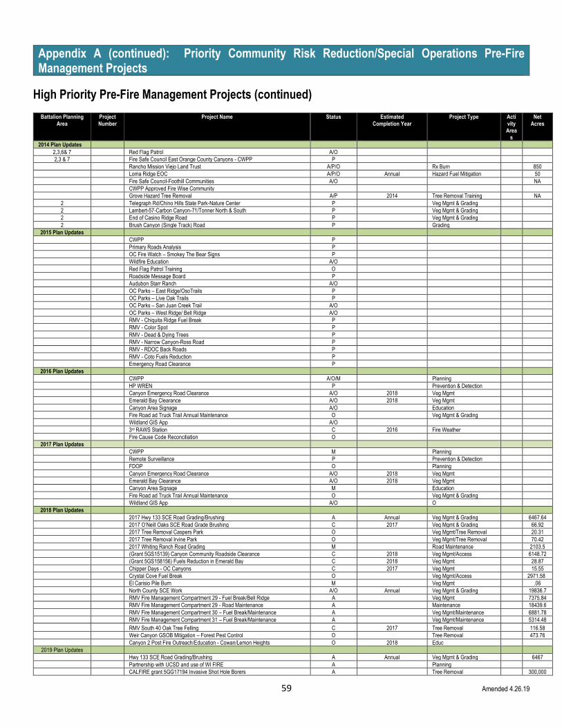
59 Amended 4.26.19
Appendix A (continued): Priority Community Risk Reduction/Special Operations Pre-Fire Management Projects
High Priority Pre-Fire Management Projects (continued)
Battalion Planning Area
Project Number
Project Name Status Estimated Completion Year
Project Type Activity Area
s
Net Acres
2014 Plan Updates
2,3,6& 7 Red Flag Patrol A/O
2,3 & 7 Fire Safe Council East Orange County Canyons - CWPP P
Rancho Mission Viejo Land Trust A/P/O Rx Burn 850
Loma Ridge EOC A/P/O Annual Hazard Fuel Mitigation 50
Fire Safe Council-Foothill Communities A/O NA
CWPP Approved Fire Wise Community
Grove Hazard Tree Removal A/P 2014 Tree Removal Training NA
2 Telegraph Rd/Chino Hills State Park-Nature Center P Veg Mgmt & Grading
2 Lambert-57-Carbon Canyon-71/Tonner North & South P Veg Mgmt & Grading
2 End of Casino Ridge Road P Veg Mgmt & Grading
2 Brush Canyon (Single Track) Road P Grading
2015 Plan Updates
CWPP P
Primary Roads Analysis P
OC Fire Watch – Smokey The Bear Signs P
Wildfire Education A/O
Red Flag Patrol Training O
Roadside Message Board P
Audubon Starr Ranch A/O
OC Parks – East Ridge/OsoTrails P
OC Parks – Live Oak Trails P
OC Parks – San Juan Creek Trail A/O
OC Parks – West Ridge/ Bell Ridge A/O
RMV - Chiquita Ridge Fuel Break P
RMV - Color Spot P
RMV - Dead & Dying Trees P
RMV - Narrow Canyon-Ross Road P
RMV - RDOC Back Roads P
RMV - Coto Fuels Reduction P
Emergency Road Clearance P
2016 Plan Updates
CWPP A/O/M Planning
HP WREN P Prevention & Detection
Canyon Emergency Road Clearance A/O 2018 Veg Mgmt
Emerald Bay Clearance A/O 2018 Veg Mgmt
Canyon Area Signage A/O Education
Fire Road ad Truck Trail Annual Maintenance O Veg Mgmt & Grading
Wildland GIS App A/O
3rd RAWS Station C 2016 Fire Weather
Fire Cause Code Reconciliation O
2017 Plan Updates
CWPP M Planning
Remote Surveillance P Prevention & Detection
FDOP O Planning
Canyon Emergency Road Clearance A/O 2018 Veg Mgmt
Emerald Bay Clearance A/O 2018 Veg Mgmt
Canyon Area Signage M Education
Fire Road ad Truck Trail Annual Maintenance O Veg Mgmt & Grading
Wildland GIS App A/O O
2018 Plan Updates
2017 Hwy 133 SCE Road Grading/Brushing A Annual Veg Mgmt & Grading 6467.64
2017 O’Neill Oaks SCE Road Grade Brushing C 2017 Veg Mgmt & Grading 66.92
2017 Tree Removal Caspers Park O Veg Mgmt/Tree Removal 20.31
2017 Tree Removal Irvine Park O Veg Mgmt/Tree Removal 70.42
2017 Whiting Ranch Road Grading M Road Maintenance 2103.5
(Grant 5GS15139) Canyon Community Roadside Clearance C 2018 Veg Mgmt/Access 6148.72
(Grant 5GS158156) Fuels Reduction in Emerald Bay C 2018 Veg Mgmt 28.87
Chipper Days - OC Canyons C 2017 Veg Mgmt 15.55
Crystal Cove Fuel Break O Veg Mgmt/Access 2971.58
El Carisio Pile Burn M Veg Mgmt .06
North County SCE Work A/O Annual Veg Mgmt & Grading 19836.7
RMV Fire Management Compartment 29 - Fuel Break/Bell Ridge A Veg Mgmt 7375.84
RMV Fire Management Compartment 29 - Road Maintenance A Maintenance 18439.6
RMV Fire Management Compartment 30 – Fuel Break/Maintenance A Veg Mgmt/Maintenance 6881.78
RMV Fire Management Compartment 31 – Fuel Break/Maintenance A Veg Mgmt/Maintenance 5314.48
RMV South 40 Oak Tree Felling C 2017 Tree Removal 116.58
Weir Canyon GSOB Mitigation – Forest Pest Control O Tree Removal 473.76
Canyon 2 Post Fire Outreach/Education - Cowan/Lemon Heights O 2018 Educ
2019 Plan Updates
Hwy 133 SCE Road Grading/Brushing A Annual Veg Mgmt & Grading 6467
Partnership with UCSD and use of WI FIRE A Planning
CALFIRE grant 5GG17194 Invasive Shot Hole Borers A Tree Removal 300,000

60 Amended 4.26.19
CALFIRE grant 5GG17193 Installation of Remote Wildfire Cameras A Fire safety and awareness
O’Neill Oaks SCE Road Grade Brushing O Veg Mgmt & Grading 67
Tree Removal Santiago O Veg Mgmt/Tree Removal
Tree Removal Irvine Park O Veg Mgmt/Tree Removal
Whiting Ranch Road Grading M Road Maintenance 2103
Chipper Days - OC Canyons O Veg Mgmt 15.55
Crystal Cove Fuel Break O Veg Mgmt/Access 2971.58
El Carisio Pile Burn O Veg Mgmt .06
North County SCE Work A/O Annual Veg Mgmt & Grading 19836.7
RMV Fire Management Compartment 29 - Fuel Break/Bell Ridge A Veg Mgmt 7375.84
RMV Fire Management Compartment 29 - Road Maintenance A Maintenance 18439.6
RMV Fire Management Compartment 30 – Fuel Break/Maintenance A Veg Mgmt/Maintenance 6881.78
RMV Fire Management Compartment 31 – Fuel Break/Maintenance A Veg Mgmt/Maintenance 5314.48
Weir Canyon GSOB Mitigation – Forest Pest Control O Tree Removal 473.76
Status Guide: A = Active, P = Planning, C = Completed, O = Ongoing, M = Maintenance
Appendix A-1: Unit Strategic Fire Plan Amendments
Fire Plan Amendments
Date Section Updates Page Number Update
Description of Update Updated by
2012 Updates 6/1/2012 Executive Summary and Key Objectives i & ii Amended text to add the necessity of reducing wildfire ignitions George Ewan
6/1/2012 Section I Unit Overview 1 & 2 Reflects updates from the addition of Santa Ana to OCFA Jurisdiction George Ewan
6/1/2012 Section II Collaboration 3 & 4 Reflects updates from the addition of Santa Ana to OCFA Jurisdiction George Ewan
4/20/2012 Exhibit 3: Division 1, Battalions 1 & 8 20 Reflects updates from the addition of Santa Ana to OCFA Jurisdiction GIS Mapping
4/20/2012 Exhibit 4: Division 2, Battalion 5 21 Reflects updates from the addition of Santa Ana to OCFA Jurisdiction GIS Mapping
4/20/2012 Exhibit 5: Division 3, Battalions 6 & 7 22 Reflects updates from the addition of Santa Ana to OCFA Jurisdiction GIS Mapping
4/20/2012 Exhibit 6: Division 4, Battalions 2 & 3 23 Reflects updates from the addition of Santa Ana to OCFA Jurisdiction GIS Mapping
4/20/2012 Exhibit 7: Division 5, Battalion 4 24 Reflects updates from the addition of Santa Ana to OCFA Jurisdiction GIS Mapping
4/20/2012 Exhibit 8: Division 6, Battalion 9 25 Reflects updates from the addition of Santa Ana to OCFA Jurisdiction GIS Mapping
4/20/2012 Exhibit 9: Unit Preparedness and Fire Fighting Capabilities 26 Reflects updates from the addition of Santa Ana to OCFA Jurisdiction GIS Mapping
6/15/2012 Appendix A 13 Updates priority projects George Ewan
2013 Updates
4/25/2013 Executive Summary and Key Objectives i Amended text to add SRA Statement Tamy Rivers
4/25/2013 Section II Collaboration 4 Reflects updates to plan development team Tamy Rivers
4/25/2013 Section V Pre-Fire Management Tactics 11&12 Updated formatting Tamy Rivers
4/25/2013 Appendix A 13 Reflects new and current projects Tamy Rivers
4/25/2013 Appendix A 14 Removed Blank page, subsequent pages renumbered Tamy Rivers
2014 Updates
5/30/2014 Appendix A 13 Updated priority projects; updated formatting; pages renumbered Kim Gomi
6/10/2014 Appendix D 28 Added Ignitions; pages renumbered Kim Gomi
2015 Updates
5/21/2015 Cover Cover Reformatted Kim Gomi
5/21/2015 Table of Contents & Signature Page i-ii Reformatted and updated with current information Kim Gomi
5/21/2015 Executive Summary & Key Objectives 1-2 Reformatted and updated with current information Kim Gomi
5/21/2015 Section I 3-9 Reformatted and updated with current information Kim Gomi
5/21/2015 Section II 10-12 Reformatted and updated with current information Kim Gomi
5/21/2015 Section III 13-15 Reformatted and updated with current information Kim Gomi
5/21/2015 Section IV 16-17 Reformatted and updated with current information Kim Gomi
5/21/2015 Section V 18-39 Reformatted and updated with current information Kim Gomi
5/21/2015 Appendices 40-46 Reformatted; 2013 Supplement now Appendix D Kim Gomi
5/21/2015 Maps Deleted Integrated maps into main plan Kim Gomi
2016 Updates
6/9/16 Cover Cover Date Change Kim Gomi
6/9/16 Table of Contents & Signature Page i-ii Updated with current information and/or reformatted Kim Gomi
6/9/16 Executive Summary & Key Objectives 1-2 Updated with current information and/or reformatted Kim Gomi
6/9/16 Section I 11 Updated with current information and/or reformatted Kim Gomi
6/9/16 Section II 12 Updated with current information and/or reformatted Kim Gomi
6/9/16 Section V 25 Updated with current information and/or reformatted Kim Gomi
6/9/16 Appendices 57-59 Updated with current information and/or reformatted Kim Gomi
2017 Updates
5/8/17 Cover Cover Date Change Kim Gomi
5/8/17 Table of Contents & Signature Page i-ii Updated with current information and/or reformatted Kim Gomi
5/8/17 Executive Summary & Key Objectives 1-2 Updated with current information and/or reformatted Kim Gomi
5/8/17 Section I 3-11 Updated with current information and/or reformatted Kim Gomi
5/8/17 Section II 12-14 Updated with current information and/or reformatted Kim Gomi
5/8/17 Section III 15-27 Updated with current information and/or reformatted Kim Gomi
5/8/17 Section IV 28-33 Updated with current information and/or reformatted Kim Gomi
5/8/17 Section V 34-45 Updated with current information and/or reformatted Kim Gomi
5/8/17 Appendices 46-55 Updated with current information and/or reformatted Kim Gomi
5/8/17 Addendums A1-A2 Added CWPP and FDOP as Addendums 1 & 2, respectively Kim Gomi
2018 Updates
5/10/17 Cover Cover Date Change Kim Gomi
5/10/17 Table of Contents & Signature Page i-ii Updated with current information and/or reformatted Kim Gomi

61 Amended 4.26.19
5/10/17 Executive Summary & Key Objectives 2-3 Updated with current information and/or reformatted Kim Gomi
5/10/17 Section I 4-13 Updated with current information and/or reformatted Kim Gomi
5/10/17 Section II 14-16 Updated with current information and/or reformatted Kim Gomi
5/10/17 Section III 17-29 Updated with current information and/or reformatted Kim Gomi
5/10/17 Section IV 30-35 Updated with current information and/or reformatted Kim Gomi
5/10/17 Section V 36-54 Updated with current information and/or reformatted Kim Gomi
5/10/17 Appendices 55-64 Updated with current information and/or reformatted Kim Gomi
2019 Updates
4/26/19 Cover Cover Updated with current information and/or reformatted Ariana Ramos
4/26/19 Table of Contents I Updated with current information and/or reformatted Ariana Ramos
4/26/19 Signature Page ii Updated with current information and/or reformatted Ariana Ramos
4/26/19 Executive Summary 1-3 Updated with current information and/or reformatted Ariana Ramos
4/26/19 Section I 9-13 Updated with current information and/or reformatted Ariana Ramos
4/26/19 Section II 14 & 15 Updated with current information and/or reformatted Ariana Ramos
4/26/19 Section IV 32-35 Updated with current information and/or reformatted Ariana Ramos
4/26/19 Section V 39, 41, 45, 55-57 Updated with current information and/or reformatted Ariana Ramos
4/26/19 Appendices 58-62 Updated with current information and/or reformatted Ariana Ramos
4/26/19 Appendices A1 & A2 Updated with current information and/or reformatted Ariana Ramos
2020 Updates
4/4/20 Entire document ALL Updated document to be ADA accessible Ariana Ramos
4/7/20 Division and Battalion Projects 41 Included information about road brushing and grading Dave Erickson
4/13/20 Battalion 6 projects 54, 55 Updated info about maintenance of projects Dave Erickson
4/20/20 2010 Key Objectives 3 Updated progress on goals Dave Erickson
4/20/20 Appendix B: 2020 Unit Fire Plan Annual Accomplishments 62 Created 2020 accomplishments Dave Erickson
4/20/20 Battalion 3 projects 45 Added project Dave Erickson
4/20/20 Section II: Collaboration 14-15 Updated progress on projects Dave Erickson
4/20/20 Population 7 Updated population of Orange County Dave Erickson
4/24/20 Unit Overview 12 Updated with current information and/or reformatted Ariana Ramos
4/24/20 Unit Overview 13 Updated with current information and/or reformatted Ariana Ramos
▪ Appendix B: 2020 Unit Fire Plan- Annual Accomplishments In 2019/2020, major accomplishments include the following:
CALFIRE SRA Review- In 2019, the OCFA Pre-Fire Management conducted the SRA review within Orange County and included acreage to return from SRA to LRA in the South Orange County area.
CALFIRE Grants: Significant progress has been made in assessing tree health and installing remote wildfire cameras. The cameras have already been successful in helping to monitor several fires.
Addition of Crew 2: Crew 2 is a 17-person hand crew that assisted with fire suppression and vegetation management projects throughout Orange County. In 2019, the crew conducted vegetation management within ~90 acres.
Addition of a Deputy Fire Marshal for Pre-Fire Management- In 2020, a civilian DFM will be hired to oversee the Pre-Fire Management section to provide continuity and support for the OCFA PFM mission.
Update to RSG website- Using funding provided by CALFIRE, OCFA will be updating the OCFA Ready Set Go website with an improved and updated online Home Assessment application. This application will be available online, as well as through a phone application, and will be used by OCFA staff and homeowners throughout the County to identify ways to protect and harden their homes from wildfire.
Fuel Reduction Projects- Completed numerous fuel reduction projects throughout the County, including invasive eucalyptus, pepper, and palm tree removals, hazard tree removals, and creating shaded fuel breaks along fire access roads.
Installation of remote wildfire cameras: Through a CALFIRE grant and in partnerships with SCE, UCSD, and many others, OCFA will be installing up to six remote wildfire cameras throughout Orange County to help monitor and confirm wildfires.
Tree Mortality - OCFA assisted with the continual removal, mapping, monitoring and treatment of drought and pest infested trees
GIS Wildland App - OCFA’s Pre-Fire Management and Information Technology Departments updated and added more information layers to their collaboratively developed multi-faceted tablet application that assists in wildland and field inspections
SCE Annual Roads Project - Completed 120 miles of brushing and/or grading SCE access roads
Fire Road & Truck Trail Annual Maintenance - Completed annual road maintenance on roads used for fire suppression and prevention
Defensible Space Inspections - Completed annual defensible space inspections
Cleveland National Forest Project - The Santiago Crew participated in mutually beneficial prescribed fire projects
Collection of Fire Perimeters - OCFA Pre-Fire Management maps every SRA vegetation fire to identify trends and determine where fuel modification zones are effective and where improvements in fuel modifications can be made

62
Appendix C: 2019 Unit Fire Plan - Annual Accomplishments In 2018/2019, major accomplishments include the following:
CALFIRE Grants: Received $5.4million in CALFIRE grants to conduct surveys and tree removals for Invasive Shot Hole Borer invaded trees. OCFA also received $90,000 in CALFIRE grants to install remote wildfire cameras.
Addition of Crew 2: Crew 2 is a 17-person hand crew that will assist with fire suppression and vegetation management projects throughout Orange County.
Fuel Reduction Projects- Completed numerous fuel reduction projects throughout the County, including invasive eucalyptus, pepper, and palm tree removals, hazard tree removals, and creating shaded fuel breaks along fire access roads.
Installation of remote wildfire cameras: Through a CALFIRE grant and in partnerships with SCE, UCSD, and many others, OCFA will be installing up to six remote wildfire cameras throughout Orange County to help monitor and confirm wildfires.
Tree Mortality - OCFA assisted with the continual removal, mapping, monitoring and treatment of drought and pest infested trees
GIS Wildland App - OCFA’s Pre-Fire Management and Information Technology Departments updated and added more information layers to their collaboratively developed multi-faceted tablet application that assists in wildland and field inspections
SCE Annual Roads Project - Completed 120 miles of brushing and grading SCE access roads
Fire Road & Truck Trail Annual Maintenance - Completed annual road maintenance on roads used for fire suppression and prevention
Defensible Space Inspections - Completed annual defensible space inspections
Cleveland National Forest Project - The Santiago Crew participated in mutually beneficial prescribed fire projects
Collection of Fire Perimeters - OCFA Pre-Fire Management maps every SRA vegetation fire to identify trends and determine where fuel modification zones are effective and where improvements in fuel modifications can be made

63 Amended 4.26.19
Appendix D: 2018 Unit Fire Plan - Annual Accomplishments In 2018, major accomplishments include the following:
Remote Surveillance – Installed remote fire/emergency detection cameras on Sheriff’s Towers, as well as cameras on Santiago Peak with associated meteorological sensors
Fuel Reduction Projects- Completed numerous fuel reduction projects throughout the County, including invasive eucalyptus tree removals, hazard tree removals, and creating shaded fuel breaks along fire access roads.
Acquisition of Additional Mechanized Equipment - A grader was purchased to improve efficiencies for vegetation management and roads projects
Tree Mortality - OCFA assisted with the continual removal, mapping, monitoring and treatment of drought and pest infested trees
GIS Wildland App - OCFA’s Pre-Fire Management and Information Technology Departments updated and added more information layers to their collaboratively developed multi-faceted tablet application that assists in wildland and field inspections
Grants - OCFA completed three grant projects, including one for Emerald Bay for additional clearance, another for East Orange County Canyons, for emergency road clearance, and installed SRA canyon area signage with interchangeable prevention messages
SCE Annual Roads Project - Completed 119 miles of brushing and grading SCE access roads
Fire Road & Truck Trail Annual Maintenance - Completed annual road maintenance on roads used for fire suppression and prevention
Defensible Space Inspections - Completed annual defensible space inspections
Cleveland National Forest Project – The Santiago Crew participated in mutually beneficial prescribed fire projects
Fuel Mapping- OCFA Pre-Fire Management purchased NDVI mapping technology to map fuels throughout the county to monitor vegetation trends and identify areas for fuel reduction projects.
Collection of Fire Perimeters- OCFA Pre-Fire Management maps every SRA vegetation fire to identify trends and determine where fuel modification zones are effective and where improvements in fuel modifications can be made
Support of CALFIRE Mission- OCFA provided a letter of support for the CALFIRE Vegetation Treatment Program Environmental Impact Report (VTP EIR)

64 Amended 7.616
Appendix E: 2017 Unit Fire Plan - Annual Accomplishments
In 2017, major accomplishments include the following:
Remote Surveillance - Secured approval to install remote fire/emergency detection cameras on Sheriff’s Towers
CWPP - Completed Orange County’s CWPP
Chipper Days Events - Conducted 5 Chipper Days in the SRA communities of Trabuco, Silverado, and Modjeska Canyons
Tree Mortality - OCFA assisted with the continual removal, monitoring and treatment of drought and pest infested trees
GIS Wildland App - OCFA’s Pre-Fire Management and Information Technology Departments added more information layers to their collaboratively developed multi-faceted tablet application that assists in wildland and field inspections
Grants - OCFA implemented three grant projects, including one for Emerald Bay for additional clearance, another for East Orange County Canyons, for emergency road clearance, and installed SRA canyon area signage with interchangeable prevention messages
SCE Annual Roads Project - Completed 119 miles of brushing and grading SCE access roads
Fire Road & Truck Trail Annual Maintenance - Completed annual road maintenance on roads used for fire suppression and prevention
Defensible Space Inspections - Completed annual defensible space inspections
FDOP - Completed OCFA’s Fire Danger Operating Plan
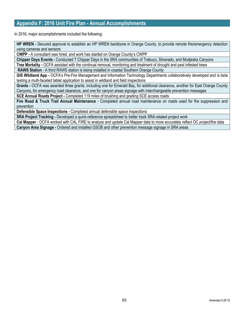
65 Amended 4.29.15
Appendix F: 2016 Unit Fire Plan - Annual Accomplishments
In 2016, major accomplishments included the following:
HP WREN - Secured approval to establish an HP WREN backbone in Orange County, to provide remote fire/emergency detection using cameras and sensors
CWPP - A consultant was hired, and work has started on Orange County’s CWPP
Chipper Days Events - Conducted 7 Chipper Days in the SRA communities of Trabuco, Silverado, and Modjeska Canyons
Tree Mortality - OCFA assisted with the continual removal, monitoring and treatment of drought and pest infested trees
RAWS Station - A third RAWS station is being installed in coastal Southern Orange County
GIS Wildland App - OCFA’s Pre-Fire Management and Information Technology Departments collaboratively developed and is beta testing a multi-faceted tablet application to assist in wildland and field inspections
Grants - OCFA was awarded three grants, including one for Emerald Bay, for additional clearance, another for East Orange County Canyons, for emergency road clearance, and one for canyon areas signage with interchangeable prevention messages
SCE Annual Roads Project - Completed 119 miles of brushing and grading SCE access roads
Fire Road & Truck Trail Annual Maintenance - Completed annual road maintenance on roads used for fire suppression and prevention
Defensible Space Inspections - Completed annual defensible space inspections
SRA Project Tracking - Developed a quick-reference spreadsheet to better track SRA-related project work
Cal Mapper - OCFA worked with CAL FIRE to analyze and update Cal Mapper data to more accurately reflect OC project/fire data
Canyon Area Signage - Ordered and installed GSOB and other prevention message signage in SRA areas

66 Amended 5.21.15
Appendix G: 2015 Supplement (For Historical Reference)
In 2014 and 2015 year-to-date, some of OCFA’s major accomplishments include the following:
Acquisition of Additional Mechanized Equipment - A masticator, mower, chipper and all-terrain skid steer tractor were purchased to improve efficiencies for vegetation management and roads projects
Additional Orange County Weather Zone – OCFA, working in partnership with COAST and NOAA, implemented a new third weather zone for Orange County, which is very helpful for making decisions regarding resource deployments, facilities closures and activity restrictions.
Adoption of MOU Between OCFA and OC Parks - For fuels mitigation and training.
Bell Ridge & West Ridge Roads - Completed Phase I of converting an existing road to a fuel break.
Bent Tree Park – Completed a grant funded project to remove over 75 large eucalyptus trees and other invasive species, then replanted the area with native vegetation, including 50 sycamores and 25 ceanothus plants.
Chipper Days Events - Conducted six Chipper Days events, in conjunction with local fire safe councils, to help reduce hazardous vegetation in the wildfire risk prone areas of Cowan Heights, and the canyon communities of Silverado and Modjeska.
Cleveland National Forest Project - A mutually beneficial prescribed fire project.
Defensible Space Inspections - Completed annual defensible space inspections for structures in SRA areas, and in the Very High and High Fire Severity Zones in LRA areas, and for power poles.
El Cariso Defensible Space SRA FPF Project – A mutually beneficial and cooperative community-based vegetation management project on the border of Orange County and Riverside County
Emerging Tree Pests of Orange County Task Force - OCFA took the lead to launch a coordinated effort in Orange County to deal with the growing issue of invasive pests (i.e. gold spotted oak borer, polyphagous shot hole borer, etc.)
Development of New Pre-Fire Management Section - OCFA’s Pre-Fire Management is now comprised of three sub-sections, which include Wildland Defense Planning, Community Wildfire Mitigation and Crews & Heavy Equipment. This new configuration will help ensure that Gray Book obligations are fulfilled and will better serve the community.
Peters Canyon Project - Removed a grove of 75 invasive palm trees in Peter’s Canyon
Re-Establishment of Relationship with CAL FIRE - To facilitate improved communications in order to better execute CAL FIRE’s mission.
SCE Roads Project - Completed 119 miles of brushing and grading SCE access roads.

67 Amended 5.21.15
Appendix H: 2013 Supplement (For Historical Reference)
The Orange County Fire Authority continues efforts to increase public awareness to the hazards presented by wildland fire due to hazardous and flammable vegetation and older construction standards and associated flammable building materials. OCFA has undertaken an aggressive approach to develop fire prevention cooperation through collaboration and partnerships.
Ready, Set, Go! (RSG) (Update: Please note that as of 2015, RSG is now considered “the message” vs. “the program”) Ready, Set, Go! (RSG), our wildfire mitigation program, is an expanding effort motivating communities, partners and stakeholders to take action. Vegetation management and wildfire preparedness are becoming evident through these partnerships. Whether it is property management, a landowner, a natural resource manager, contractor, construction material supplier, another agency or just someone interested in the program, we have all joined the effort to understand where wildfire hazards exist and educate impacted communities. Community members are proactively identifying hazards and are working to solve community problems as well as publishing and distributing information within their communities. On a larger scale, those parties with direct responsibility for managing issues, lands, and policies related to wildfires are meeting to problem solve and strategize solutions. Additionally, efforts are underway with the building industry, commercial sector, environmental conservancies, and the full range of government agencies ranging from cities up to and including the Federal levels, public utilities and other infrastructure agencies throughout the county.
Fire Safe Councils OCFA continues to assist in the development of local Fire Safe Councils in the canyon and foothill communities. In CY2012, there were four (4) Fire Safe Councils in Orange County, as of this report two (2) of these councils have upgraded to Firewise Communities. OCFA is in the early developmental stages of forming a countywide Fire Safe Council with the concept of integrating property management companies, landscape companies, HOAs and other valuable partners to become educated on wildland fire mitigation and more readily identify and share fire prevention activities, concerns, issues and solutions on a broad scale. It is OCFA’s expectation that this will bring overall public awareness to a greater understanding of potential problems and solutions.
County of Orange Area Safety Taskforce (COAST) Another endeavor that is being led by OCFA is COAST. Presently, this is in the early stages of development. COAST is a coalition of agencies, jurisdictions, landowners, conservancies, public utilities, transportation authorities and others that can affect policy to insure safety and reduce loss of property and life. The levels of individuals that represent the participating organizations are at the policy level of their respective professions. OCFA’s goal is that through this coalition it will become apparent that wildland fire is everyone’s problem and that they can play a major role in helping prevent ignitions, protection of life, property natural resources and the economy.
Other Activities Hazard tree removal, this past year, OCFA has held discussion concerning the removal of hazard trees in an avocado grove. The hazard trees are wind rows of Eucalyptus trees that have an abundant amount of either dead or dying trees. Many of the dead trees are a result of the Santiago Incident of 2007 and pose both a fire hazard should another fire occur and a safety hazard to personnel working in the grove. Efforts to gain approval for the removal are underway with the City of Irvine and The Irvine Company. Hazardous fuels mitigation, a proposal for OCFA to cut and remove hazardous vegetation surrounding the County of Orange EOCC has been discussed. This will become fuel break requiring annual maintenance and surrounding the county’s primary emergency communications site.
OCFA and Rancho Mission Viejo Land Trust and Ranch Operations have entered discussions concerning the use of prescribed fire to start reducing hazardous vegetation in preparation for future community development. These activities are in accordance with the Southern Sub Regional Wildland Fire Management Plan.
Last, OCFA continues to build cooperative efforts with the local Fire Safe Councils and canyon communities in their efforts to reduce the effects of wildland fire.

68 Amended 5.21.15
Appendix I: Priority Goals and Objectives For 2010-2012 (For Historical Reference)
Orange County Fire Authority is undertaking the development of the READY, SET, GO! Program. The Program goals are aligned with
the 2010 California Fire Plan and its objectives as listed below: (Update: Please note that as of 2015, RSG is now considered “the
message” vs. “the program”)
State Goal State Objective OCFA Goal State Goal 1 - Improve availability and use of information on hazard and risk assessment
State Goal Objective B - Engage and participate with local stakeholder groups (i.e., fire safe councils and others) to validate and prioritize the assets at risk
OCFA Goal 1 - OCFA will establish any relationships, partnerships and councils necessary to reduce wildfire risks and losses by emphasizing community-level resources and solutions. Leverage partners with common interests/or motivations
State Goal 2 - Land use planning: including general plans, new development, and existing developments
State Goal Objective B - Assist the appropriate governmental bodies in the development of a comprehensive set of wildland and wildland urban interface (WUI) protection policies for inclusion in each county general plan or other appropriate local land use planning documents
OCFA Goal 2 - OCFA will develop and sustain a portfolio of high-impact, least-cost, stakeholder-driven solutions for reducing wildfire risks and losses by creating and sustain new solutions, eliminate low-impact solutions, streamline high-cost solutions
State Goal 3 - Shared vision among communities and the multiple fire protection jurisdictions, including county-based plans and community-based plans such as Community Wildfire Protection Plans (CWPP)
State Goal Objective B - Emphasize coordination of Unit fire plans with community wildfire protection plans to encourage and support one consistency approach. Develop county or regional fire plans by bringing together community-based groups, such as fire safe councils and affected fire and land management agencies
OCFA Goal 3 - OCFA is developing the Unit Fire Plan, using the key elements identified by CAL FIRE and supporting smaller communities with the development of their local CWPP
State Goal 3 - Shared vision among communities and the multiple fire protection jurisdictions, including county-based plans and community-based plans such as Community Wildfire Protection Plans (CWPP)
State Goal Objective C - Create and support venues in which individual community member can be actively involved in local fire safe councils, community emergency response teams, FIREWISE and other community-based efforts to develop readiness plans and educate landowners to mitigate the risks and effects of wildland fire
OCFA Goal 4 - OCFA’s collaborative partners lead and drive the effort to protect communities from wildfire. OCFA’s role is transitioned into a support-oriented role, focusing primarily on active participation, facilitation and evaluation of program results
State Goal 4 - Establishing fire resistance in assets at risk, such as homes and neighborhoods
State Goal Objective A - Educate landowners, residents and business owners about the risks and their incumbent responsibilities of living in the wildland, including applicable regulations, prevention measures and preplanning activities
OCFA Goal 5 - Orange County communities understand, accepts responsibility and takes necessary action to mitigate wildfire risk, thereby preventing lives and property from being lost or damaged in wildfires OCFA Goal 6 - OCFA will develop regularly publicized motivational performance measurements in order to facilitate change in cultural attitudes, systematic mitigation of risk
State Goal 4 - Establishing fire resistance in assets at risk, such as homes and neighborhoods
State Goal Objective C - Increase the number and effectiveness of defensible space inspections and promote an increasing level of compliance with defensible space laws and regulations using CAL FIRE staffing as available, public and private organizations, and alternative inspection methods
OCFA Goal 7 - OCFA will institute a change in local cultural attitude about wildfire risks from apathy and unawareness to alertness and empowerment through mass marketing and outreach

69 Amended 5.21.15
Appendix J: 2010 Unit Strategic Plan Collaborators (For Historical Reference)
Representatives involved in the original development of the Orange County Fire Authority’s Unit Fire Plan are included in the
following table.
2010 Plan Development Team
Organization Representative (Title)
Orange County Fire Authority Wildland Fire Defense Planner
Orange County Fire Authority GIS
Orange County Fire Authority Fire Prevention
Orange County Public Works Projects & Regulatory Permits Unit
BonTerra Consulting Senior Project Manager – Restoration Ecology
Orange County Parks Director
Orange County Parks Environmental Coordination
Orange County Parks Park Rangers
HRS (Habitat Restoration Services) Restoration Specialists
Irvine Ranch Conservancy Director
Irvine Ranch Conservancy Director, Planning and Field Operations
Irvine Ranch Conservancy Field Operations Manager
Fire Safe Council Canyons of East Orange County
Ad hoc Committee
California State Parks District Environmental Scientist
Rancho Mission Viejo Land Trust VP – Open Space and Resource Management
Rancho Mission Viejo Ranch Ranch Operations
The Irvine Company – AG Operations VP – Agricultural Operations
City of Irvine Open Space Coordinator

A1 Amended 4.26.19
Addendum 1: Community Wildfire Protection Plan (CWPP)

A2
Addendum 2: Fire Danger Operating Plan (FDOP)