opportunities for restoring degraded forests and landscapes … · 2017-03-29 · opportunities for...
TRANSCRIPT

Restoration Opportunities Assessment Methodology in Ivory Coast - Final report - June 2016
Opportunities for Restoring Degraded Forests and Landscapes in Ivory Coast Final Report - June 2016
IUCN West and Central Africa Programm (PACO)

ACKNOWLEDGEMENTS The entire IUCN Team and Consultants would like to express their gratitude to all involved and to our committed donor UNEP. A number of individuals however merit special mention:
Our gratitude goes to the authors of the ROAM methodology, IUCN and WRI. Despite challenges faced, having a robust methodology was the beacon that enabled us see our end-point so clearly, it was impossible to be sidetracked by the challenges.
The following, accompanied us from Inception to Validation and have been key to our success:
The Civil Society in Ivory Coast; Mme AHOUSSI Delphine of MALEBI, Pr. EGNAKOU of SOS Forêts, Dr Therese KOUAME of CI Écologie; who accompanied the process from start to finish, helping with contacts, meetings, field visits, workshop rapporteuring, informal documentations, review of ideas and divers suggestions and general logistical support.
Ministry of Forests and Water Resources – MINEF Ivory Coast: Col SORO Doplé, the Director of Cabinet, Col SORO Yamani, the Director General, Col. EHOUSSOU, the Assistant Director General, Col. ADINGRA Chantal, Cne KOFFI Thierry, Cne ABROH Jean-Jacques and Cne DOUA Bi Yves. These persons provided initial intellectual inputs, aligning the ROAM process with the reforestation plans of SODEFOR; helped with institutional anchorage, logistical support, recruitment of consultants, information on the general public and about other Ministries. MINEF would continue enriching and supporting the process through pre-validation to validation of results, meanwhile giving it the profile that it required.
Research : We extend our gratitude to Dr Christopher KOUAME of the World Agroforestry Center –ICRAF, helping with initial contacts and explaining salient characteristics of the Ivory Coast scene, including the value of sub national consultations, such as in SOUBRE and for introducing us to State-of-the-Art Ivorian cuisine.
Ministry of the Environment and Sustainable Development- MINEDD: We cite OUATTARA Zana Inzan, KOUAKOU Amon Aphely, LEYAHI Gelase, KONAN Yao Eric, DIALA Elisabeth, Carlos RIANO, Lucien DJA, AKA Paul, and YAO Marcel, and the National Coordinator, REDD+. They helped with intellectual, institutional inputs and the step-by-step pre-validation and validation of the results; and would ensure that the process received the ultimate institutional anchorage and be better aligned with the Bonn Challenge, the Forest Investment Programme and Conventions like Aichi Target 15, and the INDC by the Ivory Coast.
Ministry of Agriculture and Rural Development - MINADER, AGBRI Lako, would help infuse aspects of the zero deforestation agriculture into process
Our gratitude goes to Mrs Emmanuelle Normand, Director of the Wild Chimpanzee Foundation in Ivory Coast for her vigorous and very useful participation in the validation workshop. Finally, our gratitude goes to Mme Thais NARCISO of UNEP, Nairobi. Thais played a very central role during this assessment; from troubleshooting the methodology, orienting the process towards the Forest Investment Program – FIP field sites, to helping to strengthen collaboration between MINEF and MINEDD, Thais was very instrumental in providing additional sources of information for the evaluation.Many more people contributed to this process; so we apologize to those whose names have not been cited. This is an ongoing process and we will surely catch up with them later on.
Project IUCN/UNEP-PCA Contact IUCN- West and Central Africa Forest Program (PACO)ANGU ANGU Kenneth, [email protected]
Technical Team IUCN-PACO: Peter MBILE: Forest and Landscape Restoration Coordinator, West and Central Africa
Elie HAKIZUMWAMI: Forest Program Officer, Central Africa Dominique ENDAMANA - Forest Program Officer
Mirjam KUZEE - ROAM Global Coordinator, IUCN Global, Washington DC
Consultants Cote d’Ivoire:
Gilbert KOUAKOU: FLR Liaison Expert
Ange-Marie BOTROH: Ingenier / Spatial Analyst & Carbon Expert
Etienne KOUMAN: Ingenier/ Spatial Analyst & Socio-Economic Expert
Editing and printingIPEC Sarl: Yaounde - Cameroon+237 699 74 47 47 / 670 04 60 04MAKOUDJOU SODA M. F.: Graphic Designer
This document has been produced with technical and financial assistance from IUCN and UNEP. The views expressed herein are those of the authors and stakeholders who participated in, and validated the results of the ROAM process in Ivory Coast, and do not necessarily reflect the official opinions of UNEP or of IUCN.
Cover Photo, courtesy MALEBI. Women’s group MALEBI developing woodlots around Dimbokoro – Center Zone of the Forest Investment Program
3
Restoration Opportunities Assessment Methodology in Ivory Coast - Final report - June 2016
TABLE OF CONTENTS
ACKNOWLEDGEMENTS............................................................................................................................................... 2
ACRONYMS.....................................................................................................................................................................4
LIST OF TABLES.............................................................................................................................................................5
LIST OF FIGURES...........................................................................................................................................................5
SUMMARY........................................................................................................................................................................6
1. INTRODUCTION............................................................................................................................................7
1.1. Overview.........................................................................................................................................................7
1.2. Implementing ROAM.......................................................................................................................................8
1.2.1. ROAM inception in the Ivory Coast: Workshop of 10 - 11 March 2016............................................................9
1.2.2. Process and main results of inception workshop............................................................................................9
1.2.3. Synthesis of results of inception workshop.....................................................................................................9
1.2.4. From inception to evaluation: 12 March – 21 June 2016...............................................................................10
1.2.6. The validation workshop: 21-22 June 2016...................................................................................................10
1.2.7. Institutional anchorage of the process...........................................................................................................11
2. RESULTS......................................................................................................................................................13
2.1. Illustration of the dimensions of degradation in the field...............................................................................13
2.2. Stakeholders analyses:...................................................................................................................................15
2.2.1. Mapping and preliminary grouping of stakeholders......................................................................................15
2.2.2. Grouping of stakeholders................................................................................................................................16
2.3. Institutional, legal and policy frameworks......................................................................................................17
2.3.1 The frameworks by land use type and by intervention...................................................................................17
2.4. Priorities and opportunities for restoration.....................................................................................................20
2.4.1. Priorities and opportunities for interventions at the national scale................................................................21
2.4.1.1. Spatial analyses of main watersheds............................................................................................................21
2.4.1.3. Spatial analyses of national parks and reserves (NPR)................................................................................23
2.4.1.4. Spatial analyses of production forests (PF)...................................................................................................23
2.4.1.5. Spatial analyses of the rural domain..................................................................................................................23
2.5. Analyses of costs and benefits of restoration................................................................................................27
2.5.1. Description of the costs and benefits of restoration......................................................................................27
2.5.3. Benefits by intervention and by land use type...............................................................................................30
2.6. Analyses of carbon sequestration potential...................................................................................................33
2.6.1. The approach used.......................................................................................................................................33
2.6.2. Estimation of the carbon sequestration potential of restoration.....................................................................34
2.7. Civil Society in the process of restoration in the Ivory Coast........................................................................37
3. CONCLUSIONS.........................................................................................................................................................40
REFERENCES...............................................................................................................................................................42

4
Restoration Opportunities Assessment Methodology in Ivory Coast - Final report - June 2016
LIST OF TABLES
Table 1: Land use types identified...........................................................................................................................15
Table 2: Mapping of stakeholders by type of intervention....................................................................................16
Table 3: Legal and Policy frameworks; existing or under development ............................................................17
Table 4: The costs to consider by land use type and by intervention.................................................................28
Table 5: Expected benefits by intervention and by land use type........................................................................28
Table 6: Default values of above-ground biomass of forests................................................................................34
Table 7: Corresponding land use types; Ivory Coast and IPCC categorizations.............................................35
Table 8: Carbon dioxide sequestration potential of identified land use systems..............................................38
Table 9: Estimation of corresponding minimum carbon dioxide sequestration potential..................................38
LIST OF FIGURES
Figure 1 : Land cover map legend (CCT, BNEDT, 2004)......................................................................................22
Figure 2 : Identification and extraction of degraded forests.................................................................................22
Figure 3 : Main watersheds of the Ivory Coast.......................................................................................................24
Figure 4 : Main centers of population and of economic activity...........................................................................24
Figure 5 : Minimum priority for restoration at the national scale..........................................................................25
Figure 6 : Minimum priority for restoration of Parks and Reserves.....................................................................25
Figure 7 : Minimum priority for restoration of Production forests.........................................................................26
Figure 8 : Minimum priority for restoration in the rural domain...............................................................................26
Figure 9 : Minimum priority for restoration in the FIP zones...................................................................................27

5
Restoration Opportunities Assessment Methodology in Ivory Coast - Final report - June 2016
ACRONYMSAFD Agence Française pour le Développement
ANADER Agence Nationale d'Appui au Développement Rural
AfDB African Development Bank
BNETD Bureau National d'Etudes Techniques et de Développement
C2D Contrat de Désendettement et de Développement
CBD Convention on Biological Diversity
CC Climate Change
UNFCCC United Framework Convention on Climate Change
CCT Centre de Cartographie et Télédétection
ECOWAS Economic Community of West African States
CIAPOL Centre Ivoirien Antipollution
CNRA Centre National de Recherche Agronomique
CORENA Conservation des ressources Naturelles
FAO Food and Agriculture Organization
GEF Global Environment Facility
FIRCA Fonds Interprofessionnel pour la Recherche et le Conseil Agricoles
FLEGT Forest Law Enforcement, Governance and Trade
FPRCI Fondation pour les Parcs et Réserves de Côte d’Ivoire
IPCC Inter-governmental Panel on Climate Change
GIZ Deutsche Gesellschaft für Internationale Zusammenarbeit
ICRAF World Agroforestry Centre
ISO International Standards Organisation
MEMIS Ministère d'État, Ministère de l'Intérieur et de la Sécurité
ROAM Restoration Opportunities Assessment Methodology
MESRS Ministère de l'Enseignement Supérieur et de la Recherche Scientifique
MINADER Ministère de l'Agriculture et du Développement Rural
MINEDD Ministère de l'Environnement et du Développement Durable
MINEF Ministère des Eaux et Forêts
MPD Ministère du Plan et du Développement
NDC Contributions Prévues au niveau National pour la COP 21
ITTO International Tropical Timber Organization
OIPR Office Ivoirien des Parcs et Réserves
ONDR Office National pour le Développement de la Riziculture
NGO Non-Governmental Organization
ONPC Office National de la Protection Civile
NTFP Non Timber Forest Products
FIP Forest Investment Program
UNEP United Nations Program for the Environment
REDD+Reducing Emissions from Deforestation and forest Degradation in developing countries and the role of Conservation, Sustainable Forest Management and Enhancement of Carbon Stocks
SODEFOR Société de Développement des Forêts
IUCN International Union for Conservation of Nature
UNESCO United Nations Educational, Scientific and Cultural Organization
UTZ Groupe de Certification de produits Agricoles
NPV Net Present Value
VAN Valeur Actualisée Nette

6
Restoration Opportunities Assessment Methodology in Ivory Coast - Final report - June 2016
SUMMARY
The Ivory Coast has an agriculture-based economy. She is a leading producer of Cocoa, Cashew, Oil Palm, and Rubber
and has been a significant exporter of tropical timber. Following the loss of more than 80% of its natural forests over a period of just 50 years; to the combined effects of small and large scale agriculture, bush fires, illegal forest exploitation and artisanal mining; including synergistic impacts of a changing micro-climate, the country now presents excellent conditions for both wide-scale and mosaic restoration efforts.
With strong political support, underlined by H.E. President ALLASSANE OUATTARA’s declaration in New York, 2014, to commit his country to Agriculture with zero deforestation and forest degradation, technical, financial partners and State institutions have become encouraged to consider forest and landscape restoration as cornerstones of national development processes; REDD+, forestry investment and agriculture. Seizing this opportunity and under contract from the United Nations Environmental Programme - UNEP, the Central and West Africa Forest Program of the World Conservation Union – IUCN-PACO, with support from the IUCN Global Forest and Climate Change Program began in March 2016 a process of implementing the Restoration Opportunities Assessment Methodology - better known as ROAM, in the Ivory Coast.
The standard ROAM analyses steps were undertaken, comprising; Introduction to forest and landscape Restoration, including global processes; Institutional anchorage of the process, National level stakeholder analyses; identification of land use types and drivers of forest degradation; identification of restoration interventions by land use type and by drivers; corroborative field visits to test degradation hypotheses; qualitative participatory analyses of restoration costs and benefits by stakeholders of land use interventions, by use types; mapping of restoration priorities, estimation of carbon sequestration potential of restoration, and assessing civil society engagement and their strategies in the restoration process.
The Ivory Coast is fully engaged to adopt restoration as a pillar in its REDD+, Agriculture and Forestry development processes. There is strong political
ownership, with MINEDD and MINEF being the leading Ministries. A wide range of stakeholders; from government, research, private sector, civil society and community-based organizations are on-board the process. Six land use types; parks and reserves, gallery forests, production forests, humid and coastal areas, mining areas and savannahs; present opportunities for wide-scale restoration; while sacred forests, cocoa, coffee and plantation systems; present excellent opportunities for mosaic-type restoration. Wide-scale restoration interventions for State revenue, local employment; conservation and ecosystem services are amply supported by existing legal texts and other policy provisions under development. Mosaic restoration for community livelihoods are supported by both State; para-public and private interests.
At the national level there are over 5 million hectares of opportunity for both wide-scale and mosaic type restoration opportunities. Over 100,000 ha of these directly support Aichi Target 15 Objectives as they pertain to Biodiversity Conservation hotspots. Secondly, and although considered by stakeholders to be an under-estimate, there are over half a million hectares of restoration opportunity for production forests. Outside these two zones, there are over 4 million hectares of restoration opportunity in the rural domain.
However, there are some challenges to applying aspects of the ROAM methodology in the field. We site; data shortages, unreliable quantitative data (production and financial); uncertainties in global economics and how these affect policies on land use and related investments. Surmounting these have required strong alignment with the functional definition of degradation and engaging very closely with stakeholders at national and at local levels during analyses. Great care was taken in the use of quantitative data to qualitatively appreciate cost and benefits of interventions; especially as it is not possible to control the factors impacting the productive base. There was a general feeling that the restoration opportunities were conservative estimates given widely held perceptions of degradation. There is therefore a need during restoration interventions, to always update existing datasets with site-specific assessments.

7
Restoration Opportunities Assessment Methodology in Ivory Coast - Final report - June 2016
INTRODUCTION
Forest and land degradation are today serious issues worldwide, particularly in developing countries. About one billion
people, or 15% of the world population, live in degrading areas, and it is estimated that about a third of the world’s population is affected by land and or forest degradation. Degradation is defined as «a persistent decline» in the goods and services provided by an ecosystem, related to water, social and economic goods and services.
In the Ivory Coast, the degradation of forest landscapes directly affects national production capacity considering that the country’s economy is heavily dependent on agriculture.
The government is aware of this situation and has already sounded the alarm and made several institutional, strategic and even taken political measures to stop degradation; reverse the situation and restore the affected forests and landscapes; and thus, support the millions of Ivorians whose livelihoods depend on the good management of these resources.
1.1. Overview
In this regard we note the 214-427 Law of 14 July 2014 pertaining to the new Forestry Code whose application texts are being drafted; including the country’s adherence to the FLEGT, REDD+ mechanisms, and the Forest Investment Program (recently approved by the World Bank), amongst other related Conventions such as the Aichi Target 15 Objectives of the Convention on biological Diversity and Others.
At the international level, the commitment of the Ivory Coast has been stated at the highest levels. In particular, in the speech by the President of the Republic H.E. ALLASSANE OUATTARA to the United Nations rostrum during the Climate Summit of September 23, 2014 in New York, he committed the Ivory Coast to cocoa production with «zero net deforestation» as from 2017.
In response to this national commitment, the International Union for Conservation of Nature (IUCN), the world leader in the application of nature-based solutions, such as landscape restoration, entered into a contractual relationship with the United Nations Environment Programme (UNEP) to assess opportunities for restoring degraded forests and landscapes in the Ivory Coast.
This Report charts and describes that process, from Inception in the Ivory Coast to Validation of the results of the Assessment.

8
Restoration Opportunities Assessment Methodology in Ivory Coast - Final report - June 2016
1.2. Implementing ROAM
In recognition of the commitments and institutional set-up in the Ivory Coast, IUCN initially benefited from guidance from the Ministry of Forests and Water resources (MINEF), one of the main would-be beneficiaries of the restoration of degraded forests. Thus, a first workshop was held in this regard on 10 - 11 March 2016 in Abidjan to begin the process of identifying opportunities to restore degraded forests and landscapes, by using
available knowledge, existing plans, policies and measures underway.
The overall objective of this workshop, spread over two (02) days, was to start the process of identification and characterization of key stakeholders, policies, and opportunities in terms of priorities and interventions; including the types of land uses, appropriate for restoration.
1.2.1. ROAM inception in the Ivory Coast: Workshop of 10 - 11 March 2016
Box 1: Engagement of key actors in the process
In a subtle departure from the recommendations of the ROAM methodology, engagement of stakeholders at the outset in Ivory Coast was not targeted or pre-prepared; but was opportunistic and linked to the activities of entities directly involved in forest management; or who had been previously contacted, e.g., women’s networks. This approach provided us with the opportunity to enter into contact with stakeholders, based on their activities and not necessarily on their expected level of political influence on the process. A constraint here was that, the Ministry of the Environment and Sustainable Development (MINEDD) the leader of the Bonn Challenge commitment; and by
implication of Landscape Restoration in the Ivory Coast, took over the process a bit late. But despite this, the robust leadership and magnanimity of MINEDD kept all previous stakeholders (e.g., MINEF) on-board; and perhaps justified the earlier opportunistic engagements of other secondary stakeholders (NGOs, Universities, Women’s groups) at the outset of the process. In the end, the principal actors of the ROAM process (in order of encounter are :) Women’s groups and Civil Society Organizations, Universities, Scientific Research, Private Sector, Ministry of Forestry, and finally MINEDD. Other structures like MINADER, the BNEDT and other technical and support services and Ministries became a part of the process by default.
Specifically, and in an exploratory manner, the first meeting/workshop had as goals, to:
4Share information and start developing a common understanding of the notion of Forest Landscape Restoration (FLR), the Bonn Challenge; and identify links with the Aichi Target 15 of the CBD, REDD + and objectives of land degradation - Rio + 20
4Identify land use types and priority systems for restoration4Select the most relevant and feasible restoration options and interventions for the country4Identify and characterize the necessary restoration investments and their different advantages and
constraints4Enumerate examples of investments, and demonstrate their carbon storage benefits4Identify key success factors of Forest and Landscape Restoration in Ivory Coast and elsewhere: the
motivations, stakeholder capacity, level of participation and the legal, policy and institutional landscape4Enumerate possible sources of support for the restoration of existing landscapes; financial and
technical partners already deployed or in the course of deployment 4Set up a multidisciplinary, inter-ministerial country “working group” of experts, to facilitate the process
towards a possible consolidated process for restoration of degraded forests and landscapes in the Ivory Coast.

9
Restoration Opportunities Assessment Methodology in Ivory Coast - Final report - June 2016
This first workshop was structured according to the requirements of ROAM and helped participants understand restoration and other related global processes.
As required by the ROAM methodology, the workshop helped to identify and assess the priorities of stakeholders involved in forest and landscape restoration, at national level. It also facilitated the identification of information gaps and helped define the structure and composition of the ‘experts working group’. It also helped advance the process of evaluating opportunities for restoration, and preparing the country for eventual adherence to the goals of the Bonn Challenge.
1.2.2. Process and main results of inception worksho p
By default, and given that this process was about restoring degraded ‘forests’, the first workshop was held under the auspices of the Ministry of Forests, Ivory Coast [MINEF]. Thirty-eight (38) people participated; comprising government officials, academics, researchers, representatives of nature conservation structures, some financial partners; NGOs and other members of civil society.
Nine presentations; covering introduction to restoration, the context and the possibilities existing in the Ivory Coast, were delivered in plenary. This was followed by four group sessions.
The results produced after the group sessions focused on : 4Relevant institutions and existing policies
supporting restoration;4The main causes of degradation of forests
and other landscapes4The impacts and perceptions of the
economic and social costs of restoration;4The knowledge and perceptions of different
types of restoration interventions;4The scope and feasibility of various
restoration interventions.
1.2.3. Synthesis of results of inception workshop
The results showed that there is strong political will, institutional and legal frameworks in Ivory Coast to support the restoration of degraded forests and landscapes. There are widespread perceptions of the different social and economic consequences of land use systems undergoing degradation. With different levels of analyses during the workshop, a good appreciation of the potentials and feasibility of various intervention strategies for restoration were articulated. It was also recognized that, a lack of timely and accurate spatial data would limit the capacities of countries to commit to possible wide scale forest and landscape restoration activities.
1.2.4. From Inception to Evaluation: 12 March – 21 June 2016
A particular pre-occupation during and after the inception process of evaluating potentials for restoring degraded landscapes was the issue of «functional degradation». It was precisely how to translate this concept, based not on a simple physical or tangible factor of change, but rather on loss of functionalities; in the context of flows of products and services, lost or being lost by a production system.
Note that, the notion of ‘degradation’ of forests [and deforestation] is a concept defined by the IPCC under the UNFCCC. It is applied as a central concept in the climate change mitigation process through reducing emissions of
Charcoal production is a major cause of tree-cover loss in Ivory Coast and an Important source of revenue

10
Restoration Opportunities Assessment Methodology in Ivory Coast - Final report - June 2016
greenhouse gases; and due to the loss of forest cover in forest-rich developing countries [REDD+]. While deforestation is more easily detected by remote sensing and other approaches, to-date, degradation is not
easy to detect and measure at large scale. Nevertheless, the issue of loss of function has always been recognized as the central element in the definition of ‘forest degradation’. However, it is after the application of methodologies such as ROAM, that a better understanding of how degradation unfolds in the field, and is evaluated in relations to its drivers, can be acquired.
Given this definition of degradation, its evaluation remains of central importance to restoration and the lessons learned from the workshop of 10-11 March 2016, relate to the next steps of issues to be resolved in the context of ROAM.
Artisanal mining is a major cause of land degradation and soil poisoning, making natural regeneration, problematic
The first three questions were used as basic issues that framed the Terms of References developed for spatial analyses, characterization of restoration costs and benefits; and carbon sequestration potential of interventions. With the constant support of MINEF during these inception stages, two consultants of Ivorian nationality (one Female, one Male) were hired to conduct the analyses. The entire analysis and reporting process was supervised by IUCN and lasted a total of forty-four [44] days, from 06 May to 20 June 2016.
1.2.5. Perceptions of degradation by landscape resource-dependent communities
As mentioned earlier, one of the concerns in the implementation of the ROAM methodology in the
field was how the phenomenon of degradation is perceived by people who use the forest resources and landscapes on a daily basis. A field visit was therefore carried out before the validation workshop to help sample some perspectives and to qualify some the results of analyses; interventions and investments proposed by stakeholders per cause of degradation, by land use system; and especially how to better articulate expected benefits and costs of restoration to be considered.
Additionally, and in view of the restoration opportunities presented by the Forest Investment Programme (FIP) to be supported by the World Bank in the Ivory Coast, the proposed FIP zones of the Centre and South West regions were selected for the visits.
These include:
4Bridging the information gap, i.e., despite the out-of-date spatial data and available topographic maps, surface areas and locations of different types of land use, etc.
4Given the lack of availability and accuracy in existing financial and economic data; and the possible non-applicability of economic analysis approaches such as Net Present Value [NPV] given data quality; how to assess and characterize the nature of the economic costs and benefits of restoration, using more appropriate tools and approaches?
4On the basis of the available spatial data, how to assess and estimate the carbon sequestration potential of different land use systems, according to international standards of carbon stock measurements and corresponding land uses [according to IPCC guidelines]
4How to ensure institutional anchorage of the process and ownership of the results of the evaluation, in the context of ongoing land use processes in the country; within zero deforestation Agriculture; in the context of the Bonn Challenge, Target 15 of the Aichi CBD objectives, and the fight against desertification,

11
Restoration Opportunities Assessment Methodology in Ivory Coast - Final report - June 2016
Degradation affects soil water availability and this negatively affects soil fertility
The main outcomes of the validation workshop were therefore : 4The participants are informed about the
history, rationale and foundation of the current process and the role of IUCN, the Bonn Challenge and related objectives; the overall situation of restoration on the African continent and of the ROAM methodology.
4The participants were informed on the strategic options for the restoration of degraded landscapes and forests in Ivory Coast; the REDD + process, the FIP and Civil Society; the National Strategic Plan for Forestry Development; Reforestation and the FLEGT process; and the agriculture policy of zero deforestation.
4The results of the application of ROAM were shared and discussed; these comprised; Stakeholder analyses, the mapping of Priorities and Opportunities for restoration, types of interventions and their justifications, an analysis of the nature of costs to be considered and benefits to be expected from restoration; including the potentials for carbon sequestration
4A final discussion of group work results focused on methodological, quantitative, qualitative and governance aspects of restoration; as guidelines towards the implementation of findings within a possible restoration process.
1.2.6. The validation workshop: 21-22 June 2016
The workshop to validate opportunities for restoring degraded forests and landscapes in the Ivory Coast was held from the 21 to 22, June 2016. It was a culmination of sharing and validation of the relevance of the results of work that began with the inception workshop of 10-11 March 2016.
This validation workshop also explored how the results of the just-completed evaluation of opportunities for restoration, would contribute to different national and global processes, such as: the Forest Investment Program [FIP], support the Ivory Coast’s Nationally Determined Contributions to the UNFCCC REDD+ (NDC),
the Aichi Target 15 of the CBD, Desertification Control, zero deforestation Agriculture policy and off-course, Reforestation in the Ivory Coast.
Therefore, the workshop sought in the first instance, to resolve some deep methodological questions. In this regard, an assessment of findings in the context of the restoration opportunities given some methodological limitations; physical, economic, social and political were performed.
Secondly, by using the results acquired through the application of ROAM, the methodology of the workshop was structured to facilitate and capture the results of discussions and clarifications considered pertinent to bring out relevant needs and fill-in information gaps in the process.
1.2.7. Institutional anchorage of the process
During the evaluation period, some institutional issues had to be carefully considered. These comprised the requirements and prospects of restoration, the adhesion of the Ivory Coast to the Bonn Challenge; including funding opportunities related thereto; contribution of forest landscape

12
Restoration Opportunities Assessment Methodology in Ivory Coast - Final report - June 2016
Box 2: Some Limits, Opportunities and Hypo-theses in the Application of ROAM.
The ROAM methodology is actually going through a Road-Test Phase. As a result, we may not on principle speak too strongly of its limits. On the other hand, we may evaluate how to render the methodology more credible in a real-world situation. So, important challenges have been encountered during key steps in data collection and analyses.
As such, important lessons can be highlighted. For instance outdated spatial data and other related land use data, such as topographic maps should ordinarily be seen as an obvious limitation, This is because, the spatial extent of degraded forests are often based on this type of data.
An additional concern has been the absence of metadata explaining how degradation was detected and how it has been defined in existing datasets. These definitions are important because, degradation in the framework of restoration as currently defined is not entirely a spatial quantity; but a dimension of functionality of systems in terms of the services that the systems provide.
Although degradation in the context of the theory and practice of restoration can be described, spatially situated or even quantitatively estimated; functionality of a degraded system – the more important dimension, can most meaningfully be described qualitatively.
As a consequence, faced by outdated maps, including not being sure about the exact spatial extent of what is described as ‘degraded’; by working at the level of different categories of land use types; and to develop a deeper case-by-case understanding of the different perceptions of degradation, we are able to produce more useful and differentiated results. Knowing that the total surface of the Ivory Coast has not changed since production of the outdated (12 year old map), we can still be certain that, the mapped extents of ‘degraded’ forests are at the very least the minimum area to be considered for restoration.
An important message here is that, the extent of deforestation – the more easily mapped phenomenon is not identical to degradation. Therefore, this hypothesis needs to be tested by evaluating the extent to which deforestation and forest degradation are correlated in the context of restoration.
Restoration of watersheds is possible and can positively impact all downstream land use and livelihoods activities
restoration to Target 15 Aichi under the CBD, the fight against desertification, and especially the huge potential contribution of restoration towards carbon sequestration in the Ivory Coast. As a result of these considerations, the emergence of the Ministry of Environment and Sustainable Development (MINEDD) – responsible for Conventions in general, as leader of the process became ever more inevitable.
However, in her prior involvement, the Ministry of Forestry (MINEF), in leading the inception workshop, development of the terms of reference for the study, recruitment and coaching of the
two young Ivorian consultants had also made important preparatory contributions towards the institutional anchorage of the process.
Therefore, and purely accidentally, instead on just one Ministry (MINEDD) two Ministries had become fully engaged in the process.
So the results of this evaluation of the Assessment Methodology in Ivory Coast were shared with the general public under the patronage of the Ministry of the Environment and Sustainable Development; with the support and collaboration of the Ministries of Forestry.

13
Restoration Opportunities Assessment Methodology in Ivory Coast - Final report - June 2016
These results are organized according to the main stages of the implementation of ROAM in the Ivory Coast. The presentation
is done as follows:
4Illustration of the dimensions of degradation in the field
4Stakeholders analyses 4The policy, legal and institutional frameworks
supporting restoration4The spatial extents of priorities for restoration
represented by the figures and maps4A qualitative analysis of the costs to consider
and expected benefits4An analysis of the carbon sequestration
potential of the restoration options4A presentation of the manner of involvement of
civil society in the process
4At the end, a brief conclusion that summarizes the key points to retain and the next steps as recommended by the participants is presented.
Box 3. The vicious circle of degradation in the Center and South Eastern zones of the Ivory Coast
Context :
Farmers in the town of Dimbokro, mostly small-scale, are in the Centre Zone of the FIP in the Ivory Coast. The limits of their locality border the production forest of AHUA.
The production forest of AHUA is subject to a management plan. This plan includes several goals, comprising the production of timber, protection (gallery forests and humid areas, recreation - tourism, a series of limited agricultural areas, and cemeteries in sacred groves).
The surrounding landscape is mixed and dominated by degraded primary forests, secondary forests and woodlands. Natural regenerations of some species, (Iroko, Samba, Ako, Cheese and Kodibé) have been observed here.
Dimensions, drivers and consequences of degradation
This is also an area of high cocoa production, the main cash crop in the Ivory Coast. However,
this area is also facing the problem of ageing cocoa orchards. The first plantations date from the 60s and 70s. Despite the support of MINADER through the provision of improved seedlings of cocoa, production continues to decline significantly. One of the main factors behind this drop in production is drought, which in recent years has been especially intense and prolonged. The drought also affects tree crops such as oil palm, cashew, and food crops grown mainly by women.
Frustrated by the continuing failures especially of cocoa, young people are turning to poaching in the forest including in the production forest of AHUA, and especially, to the production and sale of charcoal. They also practice hunting in other nearby forests and savannas using bushfires as a hunting tactic.
To compensate for the fall in farm incomes, the general population of the area is heavily involved in systematic felling of naturally growing trees for the production of charcoal. The population of the area is not interested in planting trees. They give as reasons the lack of awareness of any security of tenure of any planted trees.
2. RESULTS
Degradation causes water stress, and requires communities to go long distances for water, impacting women
2.1. Illustration of the dimensions of degradation in the field

14
Restoration Opportunities Assessment Methodology in Ivory Coast - Final report - June 2016
So, despite the possibility of natural regeneration in the area, the vicious cycles of drought, bushfires, lack of security of tenure and tree ownership, does not encourage farmers to nurture the naturally regenerated trees or to plant new ones.
In addition, the existing laws encourage small wood exploiters to cut-down high value economic species of trees regardless of their location, even in farmers’ fields.
With a shortage of trees for fuelwood (locally called ‘Bundle’) in the rural areas, local residents, especially youths, are obliged to go into classified forests. In extreme cases, farmers use the branches cocoa trees for the production
of charcoal or as wood fuel in their homes.
In spite of this - especially in terms of security of tenure, there is a strong and tangible recognition by the public, of the relentless degradation of forest landscapes in particular; as being at the origin of the decline in agricultural productivity; the incidence of localized drought, the increase in local poverty and the exodus of youths to the forests and lands in the southwest of the country (FIP Zone southwest) and even to Liberia and to Guinea Conakry.
The findings are unanimous that this vicious cycle of degradation of lands and resources, poverty and migration are strongly linked to the disappearance of trees and of healthy, natural forests.
So in unanimity, the diverse realities and manifestations of degradation of cocoa fields, secondary forests, savannas, soil, food crop fields; gallery and primary forests are all linked not so much to a reduction in the absolute area covered by the resource, but to their usefulness to the population.
Resolving the components of this cycle of degradation, equally encountered during the visit to SOUBRE in the south eastern zone of the FIP are thus in a de facto manner at the center of our analyses of actors, opportunities and priorities for restoration; the costs to be considered, benefits to be expected, including potentials for carbon sequestration by the restored landscapes.

15
Restoration Opportunities Assessment Methodology in Ivory Coast - Final report - June 2016
2.2. S
take
hold
ers a
nalys
es:
2.2
.1. M
appi
ng an
d pr
elim
inar
y gro
upin
g of
stak
ehol
ders
Tabl
e 1: L
and
use t
ypes
iden
tified
Land
Use
type
s ide
ntifie
d
Natio
nal le
vel a
ctors
Main
Sta
keho
lders
Loca
l leve
l Acto
rsTe
chnic
al an
d Fi
nanc
ial P
artn
ers
1Pr
otec
ted A
reas
: Pa
rks a
nd n
atur
al
rese
rves
(PNR
)M
INED
D (O
IPR)
, FPR
CI, M
PD,
MES
RS
Loca
l par
k and
rese
rve
m
anag
emen
t com
mitte
es
(in lia
ison
with
loca
l coll
ec-
tivitie
s), N
GOs
GIZ,
UNE
P, U
NESC
O, S
tate
, GIZ
, Coo
péra
tion
Ivoiro
-japo
nnais
e,
C2D,
UNE
P, W
orld
Bank
, UIC
N, W
CF,
Poss
ibility
of a
ssoc
iating
loca
l coll
ectiv
ities.
2
Prod
uctio
n fo
rests
SODE
FOR,
MIN
EF, W
ood
value
chain
ope
r-at
ors,
NGOs
Colle
ctivit
ies, lo
cal c
omm
unitie
s and
NG
Os.
WCF
, OIB
T, Co
opér
ation
Ivoir
o-Ja
ponn
aise,
ITTO
, CNT
IG, B
NETD
, C2
D CO
RENA
, GEF
, FAO
, Coo
péra
tion
Ivoiro
-Jap
onna
ise, G
IZ,
Woo
d va
lue ch
ain o
pera
tors
, NGO
s
Poss
ibility
of a
ssoc
iating
loca
l coll
ectiv
ities
3Ru
ral D
omain
3.
1.Ag
ricult
ural
mos
aics;
Coco
a, co
ffee,
oil
palm
syste
ms,
etc.
M
INAD
ER, A
NADE
R, M
INED
D (C
IAPO
L),
MIN
EFOw
ning
farm
ers,
NGOs
Rainf
ores
t Allia
nce,
ISO,
UTZ
, Sta
te, A
FD, U
NDP,
GIZ
, Agr
icultu
re
coop
erat
ive,
ISO,
Pro
gram
me-
Quali
té, R
esea
rch
(CNR
A, C
entre
su
isse,
ICRA
F)
3.2
Priva
te p
lanta
tions
MIN
ADER
, MEM
IS (L
ocal
Adm
inistr
ation
and
co
llecti
vities
), BN
ETD,
Aut
horiz
ed Te
chnic
al Ag
ents
(OTA
)
Indiv
idual
owne
rs, b
usine
ss p
erso
ns,
NGOs
. St
ate,
FIR
CA, A
NADE
R, B
NETD
, OIB
T
3.3.
Sava
nnah
s, wo
oded
sava
nnah
s and
se
cond
ary f
ores
ts.
M
INAD
ER, A
NADE
R, C
NRA,
Con
seil C
a-fé
-Cac
ao, p
rivat
e bu
sines
ses
Agric
ultur
e co
oper
ative
s Coll
ectiv
ities,
local
com
mun
ities a
nd N
GOs,
Busi-
ness
per
sons
Stat
e, A
gricu
lture
Cop
erat
ives,
Colle
ctivit
ies a
nd P
rivat
e En
terp
rises
, (OL
AM,
Carg
ill)
3.3
*Mini
ng a
reas
and
aba
ndon
ed m
ines
M
INEF
, MIN
ADER
, ANA
DER,
CNR
A, O
NDR,
M
MI,
Nige
r Bas
in Au
thor
ity (A
BN),
Volta
Ba
sin A
utho
rity (
VBA)
, BNE
TD, M
INEF
, M
INED
D, O
NPC
Colle
ctivit
ies, lo
cal c
omm
unitie
s and
NG
Os, A
rtisa
ns m
iners
,St
ate,
AfD
B, W
orld
Bank
, BID
, AFD
, Nige
r Bas
in Au
thor
ity (N
BA),
Volta
Bas
in Au
thor
ity (V
BA),
ONPC
(Offic
e Na
tiona
l de
la Pr
otec
tion
Civil
e)
3.4
*Gall
ery f
ores
ts SO
DEFO
R, M
INEF
, MIN
EDD,
MIN
ADER
, M
PDCo
llecti
vities
and
NGO
sRA
MSA
R Co
nven
tion,
CBD
-Aich
i, Pos
sibilit
y of a
ssoc
iating
loca
l coll
ectiv
ities,
ECOW
AS, W
orld
Bank
, AfD
B (F
IP)
3.5
*Sac
red
fore
stsM
INEF
, MIN
ADER
, SOD
EFOR
,Co
llecti
vities
, neig
hbor
ing co
mm
uni-
ties ,
Cha
mbe
r of k
ings a
nd tr
aditio
nal
ruler
s (M
EMIS
), NG
Os
CBD-
Aich
i, Sta
te, N
GOs,
Villa
ge P
opula
tions
,
Colle
ctivit
ies
3.6
*Man
grov
es, c
oasta
l and
hum
id zo
nes
M
INED
D (O
IPR)
, MIN
EF, M
MI,
SODE
FOR,
M
inistr
y of S
cient
ific re
sear
ch a
nd h
igher
ed
ucat
ion.,
MPD
Colle
ctivit
iesRA
MSA
R (h
umid
zone
s), G
EF, S
tate
, GEF
, Pos
sibilit
y of a
ssoc
iating
loca
l co
llecti
vities
*The
se ca
n also
exist
in P
arks
and i
n natu
ral re
serve
s

16
Restoration Opportunities Assessment Methodology in Ivory Coast - Final report - June 2016
2.2.2.
Gro
upin
g of
stak
ehol
ders
Tabl
e 2: M
appi
ng o
f sta
keho
lder
s by t
ype o
f int
erve
ntio
n La
nd U
se ty
pes
iden
tified
Type
of R
esto
ratio
n in
terv
entio
ns
Mai
n st
akeh
olde
rsN
atio
nal l
evel
act
ors
Loca
l lev
el a
ctor
s1
Prot
ecte
d Ar
eas
: Par
ks a
nd
natu
ral
-
Man
agem
ent o
f inh
abita
nts
or h
abita
ts in
a p
artic
ipat
ory
man
ner
- In
vasi
ve S
peci
es C
ontro
l Stra
tegi
es
- Ef
fect
ive
mon
itorin
g of
a m
inim
um o
f res
tora
tion
prio
rity
MIN
EDD
(OIP
R),
FPR
CI,
MPD
, M
ESR
S Lo
cal p
arks
and
rese
rves
m
anag
emen
t com
mitt
ees
(in
conj
unct
ion
with
loca
l aut
horit
ies
) , N
GO
s
2Pr
oduc
tion
fore
sts
-
Writ
ing,
val
idat
ion
and
codi
ng
-
Par
ticip
ator
y m
anag
emen
t pla
ns :
-
Lan
d te
nure
sec
urity
,
-
Encr
oach
men
t Man
agem
ent O
ptio
ns
-
Hum
an s
ettle
men
ts a
nd a
gric
ultu
ral fi
elds
;
-
Surv
eilla
nce
agai
nst b
ush
fires
,
-
illega
l log
ging
and
poa
chin
g ;
-
Ref
ores
tatio
n
SOD
EFO
R, M
INEF
, op
erat
ors
of th
e tim
ber s
ecto
r, O
NG
Col
lect
iviti
es, l
ocal
com
mun
ities
, aut
hori-
ties,
NG
Os
3R
ural
Dom
ain
3.
1.Ag
ricul
tura
l mos
aics
; C
ocoa
, co
ffee,
oil
palm
sys
tem
s, e
tc.
- C
ocoa
Cer
tifica
tion
- P
rom
otio
n of
cof
fee,
cas
hew
pla
ntat
ions
, ru
bber
a
nd o
il pa
lm -b
ased
Agr
ofor
estry
;
- T
rain
ing
and
phyt
osan
itary
mon
itorin
g
- T
he im
plem
enta
tion
of w
ater
har
vest
ing
tech
niqu
es;
- O
rcha
rds
reju
vena
tion
stra
tegy
,
- p
rote
ctio
n ag
ains
t bus
hfire
s
MIN
ADER
, AN
ADER
, MIN
EDD
(CIA
POL)
, M
INEF
Ow
ning
farm
ers,
NG
Os
3.2
Priv
ate
plan
tatio
ns-
Secu
re a
cces
s to
land
MIN
ADER
, MEM
IS (L
ocal
adm
inis
tratio
n an
d co
llect
iviti
es),
BNET
D, a
utho
rized
tech
nica
l op
erat
ors
(OTA
)
Indi
vidu
als,
bus
ines
s pe
rson
s an
d N
GO
s
3.3.
Sava
nnas
, woo
ded
sava
nnas
an
d se
cond
ary
fore
sts.
- Cre
atio
n of
pla
ntat
ions
of f
ast-
grow
ing
trees
- The
impl
emen
tatio
n of
wat
er h
arve
stin
g te
chni
ques
MIN
ADER
, AN
ADER
, CN
RA,
Con
seil
Caf
é-C
a-ca
o, p
rivat
e en
terp
rises
Ag
ricul
tura
l coo
pera
tives
, Loc
al A
utho
ri-tie
s , N
GO
s, tr
ader
s

17
Restoration Opportunities Assessment Methodology in Ivory Coast - Final report - June 2016
2.3. In
stitu
tiona
l, leg
al an
d po
licy f
ram
ewor
ks
2.3.1
The f
ram
ewor
ks b
y lan
d us
e typ
e and
by i
nter
vent
ion
Tabl
e 3: L
egal
and
Polic
y fra
mew
orks
; exis
ting
or u
nder
dev
elopm
ent
3.3
*Mini
ng a
reas
and
aba
ndon
ed
mine
s
-
Cre
ation
of p
lanta
tions
of f
ast-
grow
ing tr
ees
- Im
plem
ent t
he re
gulat
ions i
n fo
rce
for a
rtisa
nal m
ining
an
d co
ntro
l mea
sure
s for
fore
st fir
es
MIN
EF, M
INAD
ER, A
NADE
R, C
NRA,
OND
R,
MM
I, Aut
orité
du
Bass
in du
Nige
r (AB
N), A
utor
i-té
du
Bass
in de
la V
olta
(ABV
), BN
ETD,
MIN
EF,
MIN
EDD,
ONP
C
Colle
ctivit
ies, N
GOs a
nd a
rtisa
nal m
iners
3.4
*Gall
ery f
ores
ts
- Im
plem
ent m
anag
emen
t plan
s for
hum
id zo
nes a
nd
galle
ry fo
rests
SO
DEFO
R, M
INEF
, MIN
EDD,
MIN
ADER
, MPD
Colle
ctivit
ies, N
GOs
3.5
*Sac
red
fore
sts-
Supp
ort t
o co
mm
unity
-bas
ed b
y-law
s
- Bu
ild m
anag
emen
t cap
acitie
s of c
omm
unitie
s man
aging
sa
cred
fore
sts
- Ex
tens
ion/se
nsitiz
ation
and
esta
blish
men
t of t
enur
e ce
rtific
ates
- Pr
ovide
supp
ort t
o as
siste
d na
tura
l reg
ener
ation
MIN
EF, M
INAD
ER, S
ODEF
OR,
Colle
ctivit
ies, lo
cal c
omm
unitie
s, au
thor
i-tie
s, NG
Os Ho
use
of T
radit
ional
Ruler
s and
Ki
ngs (
MEM
IS
3.6
*Man
grov
es, c
oasta
l and
hu-
mid
zone
s
- Ef
fecti
ve su
rveil
lance
of a
mini
mum
of t
he p
riorit
y for
re
stora
tion
M
INED
D (O
IPR)
, MIN
EF, M
MI,
SODE
FOR,
Min-
istry
of R
esea
rch
and
High
er E
duca
tion,
MPD
Colle
ctivit
ies, lo
cal c
omm
unitie
s, au
thor
i-tie
s, NG
Os
Land
Use
type
s ide
n-tifi
edPr
incipa
l cau
ses o
f deg
-ra
datio
nTy
pes o
f Res
to-ra
tion I
nterve
n-tio
n
Lega
l, poli
tical
and i
nstitu
tiona
l fram
ewor
k in e
xisten
ce or
unde
r dev
elopm
ent
Prote
cted A
reas
: Pa
rks an
d natu
ral
rese
rves (
PNR)
Farm
s and
ha
bitati
ons
Poac
hing
Mana
geme
nt of
inhab
itants
or
habit
ats
Law
n° 20
02-1
02 of
11 F
ebru
ary 2
002 r
elativ
e to t
he cr
eatio
n, ma
nage
ment
and fi
nanc
-ing
of na
tiona
l par
ks an
d natu
ral re
serve
s.
Conv
entio
ns in
terna
tiona
les

18
Restoration Opportunities Assessment Methodology in Ivory Coast - Final report - June 2016
*Man
grov
es, c
oast
al
and
hum
id z
ones
M
inin
g
Bus
h fir
es
Effe
ctiv
e su
r-ve
illan
ce o
f a
min
imum
of t
he
prio
rity
for
res
to-
ratio
n
Dra
ft D
ecre
e de
finin
g fo
rest
man
agem
ent m
odal
ities
for
prot
ectin
g ba
nks,
slo
pes
and
wat
er-
shed
sLa
w n
° 95
-553
du
17 J
uly
1995
min
ing
code
Law
n°9
8-75
5 du
23
Dec
embe
r 19
98 W
ater
cod
e;La
w N
° 20
14-4
27 d
u 14
Jul
y 20
14 o
n th
e F
ores
try
code
La
w N
° 96
-766
du
03 O
ctob
er 1
996
envi
ronm
enta
l cod
e C
onve
ntio
n R
AM
SA
R r
elat
ive
to th
e pr
otec
tion
of h
umid
zon
es o
f int
erna
tiona
l sig
nific
ance
. *G
alle
ry fo
rest
s
Exp
loita
tion
of w
ood
ener
gy
Ero
sion
Inva
sive
spe
cies
Impl
emen
tatio
n of
a m
anag
emen
t pl
an fo
r w
etla
nds
and
galle
ry fo
r-es
ts
Law
N°9
8-75
0 du
23-
12-9
8 m
odifi
ed b
y la
w N
° 20
04-4
12 d
u 14
of A
ugus
t 200
4 pe
rtai
ning
to
land
tenu
re in
the
rura
l dom
ain
Law
N°
96-7
66 o
f 03
Oct
ober
199
6 on
the
envi
ronm
ent c
ode
Dra
ft D
ecre
e de
finin
g fo
rest
man
agem
ent m
odal
ities
for
prot
ectin
g ba
nks,
slo
pes
and
wat
er-
shed
sLa
w N
o. 2
012-
1128
of 1
2 D
ecem
ber
2012
on
the
orie
ntat
ion
of T
errit
oria
l Adm
inis
trat
ion
Inva
sive
spe
cies
co
ntro
l str
ateg
ies
Law
N°
96-7
66 o
f 03
Oct
ober
199
6 on
the
Env
ironm
enta
l Cod
e
Dra
ft fo
rest
man
agem
ent D
ecre
e an
d m
odal
ities
indi
spen
sabl
e fo
r pr
otec
tion
of b
anks
, sl
opes
an
d w
ater
shed
s La
w N
o. 2
012-
1128
of 1
2 D
ecem
ber
2012
on
the
orie
ntat
ion
of T
errit
oria
l Adm
inis
trat
ion
Land
Use
Typ
es
Cau
ses
of d
egra
datio
n
Type
s of
rest
o-ra
tion
Inte
rven
tion
Le
gal,
polit
ical
and
inst
itutio
nal f
ram
ewor
k in
exi
sten
ce o
r und
er d
evel
opm
ent
Pro
duct
ion
fore
sts*
Fiel
ds a
nd h
ouse
s
poac
hing
Min
ing
Bus
hfire
s
illeg
al e
xplo
itatio
n
Writ
ing,
val
idat
ion
and
codi
ficat
ions
Law
N°
2014
-427
of 1
4 Ju
ly 2
014
on th
e Fo
rest
Cod
e an
d its
impl
emen
ting
regu
latio
nsD
ecre
e N
0 93-
206
of 3
Feb
ruar
y 19
93 d
efini
ng th
e m
issi
ons
of S
OD
EFO
RD
ecre
e N
66-
422
of 1
5 S
epte
mbe
r 196
6 es
tabl
ishi
ng S
OD
EFO
R a
s st
ate
com
pany
Ref
ores
tatio
nLa
w N
° 20
14-4
27 o
f 14
July
201
4 on
the
Fore
st C
ode
and
its im
plem
entin
g re
gula
tions
D
ecre
e N
0 93-
206
of 3
Feb
ruar
y 19
93 d
efini
ng th
e m
issi
ons
of S
OD
EFO
RD
ecre
e N
66-
422
of 1
5 S
epte
mbe
r 196
6 es
tabl
ishi
ng S
OD
EFO
R a
s st
ate
com
pany
Per
Ha
surv
eil-
lanc
e ag
ains
t bus
h fir
es ,
illeg
al lo
g-gi
ng a
nd p
oach
ing
Law
N°
2014
-427
of 1
4 Ju
ly 2
014
on th
e Fo
rest
Cod
e an
d its
impl
emen
ting
regu
latio
ns
Dec
ree
N0 9
3-20
6 of
3 F
ebru
ary
1993
defi
ning
the
mis
sion
s of
SO
DE
FOR
Dec
ree
N0 6
6-42
2 of
15
Sep
tem
ber 1
966
esta
blis
hing
SO
DE
FOR
as
stat
e co
mpa
ny D
ecre
e N
20
12 -1
0 49
of 2
4 O
ctob
er 2
012
esta
blis
hing
the
Nat
iona
l Com
mis
sion
RE
DD
+E
ncro
achm
ent
man
agem
ent
optio
ns fo
r hum
an
settl
emen
ts a
nd
agric
ultu
ral fi
elds
Law
N°
2014
-427
of 1
4 Ju
ly 2
014
on th
e Fo
rest
Cod
e an
d its
impl
emen
ting
regu
latio
ns
Dec
ree
N0 9
3-20
6 of
3 F
ebru
ary
1993
defi
ning
the
mis
sion
s of
SO
DE
FOR
Dec
ree
N0 6
6-42
2 of
15
Sep
tem
ber 1
966
esta
blis
hing
SO
DE
FOR
as
stat
e co
mpa
ny
Law
N°
96-7
66 o
f 03
Oct
ober
199
6 on
the
Env
ironm
ent C
ode
Land
tenu
reG
azet
ting
dire
ctiv
es

19
Restoration Opportunities Assessment Methodology in Ivory Coast - Final report - June 2016
Land
Use
type
s
Cau
ses
of D
egra
-da
tion
Ty
pes
of R
esto
ratio
n In
terv
entio
n L
egal
, pol
itica
l and
inst
itutio
nal f
ram
ewor
k in
exi
sten
ce o
r und
er d
evel
opm
ent
*Sac
red
fore
sts
- Far
ms,
- hab
ita-
tions
,
- Poa
chin
g,
- min
ing
and
Bus
h fir
es
Sup
port
to c
omm
uni-
ty-b
ased
by-
law
s.
Law
N°
2014
-427
of 1
4 Ju
ly 2
014
on th
e Fo
rest
ry C
ode
and
decr
ees
of a
pplic
atio
n.
Pro
ject
on
the
reha
bilit
atio
n of
sac
red
fore
sts
in th
e Iv
ory
Coa
st.
Cap
acity
bui
ldin
g in
co
mm
uniti
es w
ith S
acre
d fo
rest
s.
Law
N°
2014
-427
of 1
4 Ju
ly 2
014
on th
e Fo
rest
ry C
ode
and
decr
ees
of a
pplic
atio
n.
Pro
ject
on
the
reha
bilit
atio
n of
sac
red
fore
sts
in th
e Iv
ory
Coa
st.
Ext
ensi
on a
nd e
stab
lish-
men
t of l
and
certi
ficat
esLa
w N
°98-
750
of 2
3-12
-98
mod
ified
by
law
N°
2004
-412
of 1
4 A
ugus
t 200
4 pe
rtain
ing
to th
e ru
ral d
omai
n
Ass
iste
d na
tura
l reg
en-
erat
ion
Law
N°
2014
-427
of 1
4 Ju
ly 2
014
on th
e Fo
rest
ry C
ode
and
decr
ees
of a
pplic
atio
n.
Dec
ree
N0 9
3-20
6 of
3 F
ebru
ary
1993
defi
ning
the
mis
sion
s of
SO
DE
FOR
Dec
ree
N0 6
6-42
2 of
15
Sep
tem
ber 1
966
esta
blis
hing
SO
DE
FOR
as
stat
e co
mpa
nyP
rivat
e P
lant
atio
ns- A
ging
orc
hard
s,
- Exc
ess
use
of
Phy
tosa
nita
ry p
rod-
ucts
- Dro
ught
- Ille
gal E
xplo
itatio
n of
tim
ber,
- Ove
r exp
loita
tion
of
woo
d,
- Ero
sion
- Des
ertifi
catio
n ,
- Pol
lutio
n of
soi
l and
w
ater
- Bus
hfire
s
Sec
urin
g ac
cess
to la
ndLa
w N
°98-
750
of 2
3-12
-98
mod
ified
by
law
N°
2004
-412
of 1
4 A
ugus
t 200
4 pe
rtain
ing
to th
e ru
ral d
omai
n
Law
N°
96-7
66 o
f 03
Oct
ober
199
6 on
the
Env
ironm
ent C
ode
Law
n°9
8-75
5 du
23
Dec
embe
r 199
8 W
ater
cod
e;
Law
n°
95-5
53 d
u 17
Jul
y 19
95 m
inin
g co
de
Dra
ft or
ient
atio
n la
w o
n Te
rrito
rial A
dmin
istra
tion
C
ocoa
sys
tem
s P
hyto
sani
tary
trai
ning
and
m
onito
ring
Law
N°
96-7
66 o
f 03
Oct
ober
199
6 on
the
envi
ronm
ent c
ode
Doc
umen
t of t
he a
ppro
ved
list o
f pes
ticid
es p
erm
itted
in Iv
ory
Coa
st
Law
n°9
8-75
5 du
23
Dec
embe
r 199
8 W
ater
cod
e;
Pro
gram
me-
Qua
lité
Gro
wth
of q
uant
ity a
nd q
ualit
y in
the
Cof
fee
and
Coc
oa in
dust
ry
Cof
fee
Sys
tem
s

20
Restoration Opportunities Assessment Methodology in Ivory Coast - Final report - June 2016
Land
Use
type
s
Caus
es o
f Deg
rada
tion
Ty
pes
of R
esto
ratio
n In
terv
entio
n L
egal
, pol
itical
and
inst
itutio
nal f
ram
ewor
k in
exis
tenc
e or
und
er d
evel
opm
ent
*Sac
red
fore
sts
- Far
ms,
- hab
itatio
ns,
- Poa
chin
g,
- min
ing
and
Bush
fire
s
Supp
ort t
o co
mm
uni-
ty-b
ased
by-
laws
. La
w N°
201
4-42
7 of
14
July
2014
on
the
Fore
stry
Cod
e an
d de
cree
s of
app
licat
ion.
Proj
ect o
n th
e re
habi
litatio
n of
sac
red
fore
sts
in th
e Iv
ory
Coas
t.
Capa
city
build
ing
in
com
mun
ities
with
Sac
red
fore
sts.
Law
N° 2
014-
427
of 1
4 Ju
ly 20
14 o
n th
e Fo
rest
ry C
ode
and
decr
ees
of a
pplic
atio
n.
Proj
ect o
n th
e re
habi
litatio
n of
sac
red
fore
sts
in th
e Iv
ory
Coas
t.
Exte
nsio
n an
d es
tabl
ish-
men
t of l
and
certi
ficat
esLa
w N°
98-7
50 o
f 23-
12-9
8 m
odifie
d by
law
N° 2
004-
412
of 1
4 Au
gust
200
4 pe
rtain
ing
to th
e ru
ral d
omai
n
Assis
ted
natu
ral r
egen
-er
atio
nLa
w N°
201
4-42
7 of
14
July
2014
on
the
Fore
stry
Cod
e an
d de
cree
s of
app
licat
ion.
Decr
ee N
0 93-
206
of 3
Feb
ruar
y 19
93 d
efini
ng th
e m
issio
ns o
f SO
DEFO
R
Decr
ee N
0 66-
422
of 1
5 Se
ptem
ber 1
966
esta
blish
ing
SODE
FOR
as s
tate
com
pany
Priva
te P
lant
atio
ns- A
ging
orc
hard
s,
- Exc
ess
use
of
Phyt
osan
itary
pro
duct
s
- Dro
ught
- Ille
gal E
xplo
itatio
n of
tim
ber,
- Ove
r exp
loita
tion
of w
ood,
- Ero
sion
- Des
ertifi
catio
n ,
- Pol
lutio
n of
soi
l and
wat
er
- Bus
hfire
s
Secu
ring
acce
ss to
land
Law
N°98
-750
of 2
3-12
-98
mod
ified
by la
w N°
200
4-41
2 of
14
Augu
st 2
004
perta
inin
g to
the
rura
l dom
ain
Law
N° 9
6-76
6 of
03
Oct
ober
199
6 on
the
Envir
onm
ent C
ode
Law
n°98
-755
du
23 D
ecem
ber 1
998
Wat
er c
ode;
Law
n° 9
5-55
3 du
17
July
1995
min
ing
code
Draf
t orie
ntat
ion
law
on Te
rrito
rial A
dmin
istra
tion
Co
coa
syst
ems
Phyt
osan
itary
trai
ning
and
m
onito
ring
Law
N° 9
6-76
6 of
03
Oct
ober
199
6 on
the
envir
onm
ent c
ode
Docu
men
t of t
he a
ppro
ved
list o
f pes
ticid
es p
erm
itted
in Iv
ory
Coas
t
Law
n°98
-755
du
23 D
ecem
ber 1
998
Wat
er c
ode;
Prog
ram
me-
Qua
lité
Gro
wth
of q
uant
ity a
nd q
uality
in th
e Co
ffee
and
Coco
a in
dust
ry
Coffe
e Sy
stem
s

21
Restoration Opportunities Assessment Methodology in Ivory Coast - Final report - June 2016
2.4. Priorities and Opportunities for Restoration
2.4.1. Priorities and Opportunities for Interventions at the National scale
The different categories of land-use assessed as part of this evaluation were the main types identified by the different stakeholders (state and non-state organizations, private sector, civil society organizations representatives of civil society, independent experts and technical partners); who participated during the two days of work during the 10 -11 workshop of March 2016 in Abidjan, Ivory Coast.
As a very first step, it was important to bring out all these major land use categories identified by the stakeholders by superimposing this information layer against an available map of the Ivory Coast depicting the extent and distribution of ‘degraded forests’ in that country.
However, given the qualitative dimensions of forest landscape degradation and by inference, the requirements for landscape restoration within the framework of the ROAM (IUCN and WRI, 2014); and as articulated during the workshop; including after the findings of the field trip, it was obvious that spatial representation of ‘degradation’ is not a straight-forward notion – i.e., one easily depicted and estimated on a traditional map.
To produce a map depicting ‘functional degradation’ in the context of restoration as defined, would require more than one algorithm running simultaneously, on the same scale, and each representing a different dimension (or degradation criteria). This is technically possible; however, given the time available for a ROAM assessment, the cost of running such a multi-criteria model may considerably exceed the medium-term benefits. Furthermore, the spatial presentation of the results of a multiple criteria degradation analysis; given that dimensions of degradation can be qualitative, would also pose significant challenges.
Without developing ways to spatially represent qualitative data, estimating degradation in terms of ‘surface area’ could not just be misleading, but would render interpretations such as intervention and investment costs, very challenging. Nevertheless, spatial analyses depended on the only topographic land use, land cover base map available. This map was produced by the Mapping and Remote
Sensing Centre (CCT / BNETD) in 2004. From the outset therefore, it was obvious that, this 12 year-old dataset would serve principally, only as a useful guide to the different types of land uses already identified in the workshop.
We were able to hypothesize that the assessment of the extent of priorities and opportunities for restoration often based on outdated, mapped data is likely to be only a fraction of the real situation, indicating the direction of change and probably not as related to deforestation as could be imagined. It is important that, going forward, these hypotheses are fully tested.
In this assessment, ‘priority for restoration’ was defined as areas perceived as ‘degraded’ irrespective of associated social, economic and physical characteristics. On the other hand ‘opportunities for restoration’ would be defined as the sub-set of the priorities; but where an optimum set of investment constraints have been either avoided or eliminated.
Therefore, awareness of both the age of the dataset and absence of spatial analyses of degradation did not constitute a cause for concern for a number of reasons;
Firstly, as a guide, we are able to use old data to locate ‘degradation hot spots’ and establish direction. Secondly, and based on compounding factors of human activities and natural phenomena, it was possible to develop inferences of degradation which can be further qualified [even quantified] using field information to guide restoration interventions. Finally, a combination of the knowledge of the zones described as ‘degraded’ given the age of the datasets; and the likelihood that restoration would have positive impacts well beyond the immediate zones of activity meant that overall areas restored would be much in excess of the degradation ‘hotspots’.
Thus more complete information on restoration opportunities would only emerge after analyses of the expected costs to be considered and the benefits expected from restoration investments.
A first step towards determining minimum restoration requirements began with the legend of the map produced by the Mapping and Remote Sensing Centre (CTC / BENETD) in 2004 (without any metadata) as presented below:

22
Restoration Opportunities Assessment Methodology in Ivory Coast - Final report - June 2016
This was a «raster» layer whose descriptions of the different classes were not provided. This map is also the same map used until date by the REDD+ process in the Ivory Coast and therefore was considered as a unifying dataset despite its age.
Without metadata however, it was impossible to understand what the criteria of ‘degraded forests’
were at the time of the production of this map analyses. This did not deter us, and we however, worked on the assumption that areas designated as «degraded forest» were once good quality forests but had now declined in quality. We then proceeded to extract this entire category of land use identified as ‘degraded’ according to the procedure in Figure 2 below.
Given the age of the available dataset, the multidimensional nature of functional degradation, displacement and dynamics of social and economic developments in Ivory Coast, a clear distinction had to be made between priorities and opportunities for restoration. The original idea was to glean ‘opportunities’ from ‘priorities’ for restoration according to the
ROAM methodology. Given these mitigating social, economic and temporal dynamics it was considered too ‘presumptuous’ to speak of opportunities when so many changes were still on-going.
The thesis to stick to ‘priorities’ and to go forward and confirm these as what constitutes
Limite Administrative
Réseau Routier
Limite de Forêt classée et parc
Limite de Forêt classée, parc et reserve
Sous-préfecture
Préfecture
Région
Etat
Forêt
Occupation du sol
Exploitation minière
Cocotier
Palmier
Hévéa
Café
Cacao
Reboisement
Canne à sucre
Vergers
Ananas
Bananes
Soja
Pâturages/Aménagements agricoles
Forêt dégradée
Savane arborée
Savane arbustive
Cultures ou Jachères
Bas-fonds
Forêt hydromorphe
Marécage ou mangroves
Habitat
Retenue d’eau
Îles
Sol Nu
Afleurements Rocheux
Autoroute
Route Bitûmée
Route en terre
Chemin de fer
Image d’ODS 2014 en image .jpeg Carte OCS 2014 en raster .tif
Degraded Forests as identified
Figure 1 : Land cover map legend (CCT, BNEDT, 2004)
Figure 2 : Identification and extraction of degraded forests

23
Restoration Opportunities Assessment Methodology in Ivory Coast - Final report - June 2016
‘opportunities’ for restoration was further reaffirmed during plenary sessions of the validation workshop.
Participants argued that, human settlements, population density and road networks are not sufficient criteria to determine ‘opportunity’ given the different dimensions of degradation and preferences for restoration of functional usefulness of landscapes. Thus, it was agreed that, for now, the identified ‘priorities’, given the age of the data sets and ongoing dynamics, including the novelty of restoration, should be regarded as synonymous with ‘opportunity’ for the restoration of degraded forests and landscapes in the country. Therefore, henceforth in this report, the use of the expression ‘priority for restoration’ implicitly means opportunities.
Subsequent analyzes by land use type were organized as follows:
2.4.1.1. Spatial analyses of main watersheds
The spatial analysis of the main watersheds was performed by combining the Digital Elevation Model of the Ivory Coast, vegetation and a hydrology map (Figure 3). We note a priori, two types of catchments: shared by Côte d’Ivoire and neighboring countries (Liberia, Guinea, Niger, and Ghana); and others within the Ivory Coast.
Although watersheds are an important ecological criteria for restoration, this category has not been used explicitly to extract the priorities (opportunities) for restoration, for the reasons already given, but have been presented to facilitate visualizations.
2.4.1.2. Spatial analyses of population centers and economic activities
Concentrations of human population centers, infrastructure, economic and urban activities are additional criteria with which to extract
potentially useful priorities for restoration. For the same reasons given; age of the data and the subjectivity of restoration decisions, these factors are presented in Figure 4 to facilitate visualization.
2.4.1.3. Spatial analyses of national parks and reserves (NPR)
The spatial analysis of NPR was developed from data on the network of NPR in the Côte d’Ivoire available at the National Office of Parks and Reserves (OIPR). Degraded forest areas of the NPR were obtained by super positioning the map layer of NPR on the topographic map layer with ‘degraded zones’ highlighted. From the results, the minimum area (priorities) to be restored within NPR was estimated.
2.4.1.4. Spatial analyses of production forests (PF)
Spatial analyzes of production forests (PF) of the Ivory Coast were performed using data available at the Forest Development Authority (SODEFOR). Degraded forest areas within the PF were obtained by super positioning the map layer of PF on the topographic map layer with ‘degraded zones’ highlighted. From the results, the minimum area (priorities) to be restored within PF was estimated.
2.4.1.5. Spatial analyses of the rural domain
Analyses of agricultural areas, abandoned mines and sacred forests were not developed as separate categories. This is explained by the absence of data on the spatial distribution of agricultural land including cocoa, coffee, rubber, oil palm, cashew, etc. However, large agricultural areas, agricultural mosaics’ of the country have been identified by analyzing data on agricultural and mining activities available through qualitative and quantitative field data.

24
Restoration Opportunities Assessment Methodology in Ivory Coast - Final report - June 2016
Fig
ure 3
: Ma
in wa
tersh
eds o
f the I
vory
Coas
t Fi
gure
4 : M
ain ce
nters
of po
pulat
ion an
d of e
cono
mic a
ctivit
y

25
Restoration Opportunities Assessment Methodology in Ivory Coast - Final report - June 2016
Figu
re 5
: Mini
mum
prior
ity fo
r res
torati
on at
the n
ation
al sc
ale
Sur
face A
rea =
5 07
7 672
Ha
Figur
e 6 : M
inimu
m pri
ority
for re
storat
ion of
Park
s and
Res
erves
Sur
face A
rea =
97 94
3 Ha (
contr
ibutio
n to
Aic
hi Ta
rget 1
5)

26
Restoration Opportunities Assessment Methodology in Ivory Coast - Final report - June 2016
Figu
re 7
: Mini
mum
prior
ity fo
r res
torati
on of
Pro
ducti
on fo
rests
S
urfa
ce A
rea =
556 2
98 H
a Fi
gure
8 : M
inimu
m pr
iority
for r
estor
ation
in th
e rur
al do
main
Sur
face
Are
a = 4
423 4
31 H
a

27
Restoration Opportunities Assessment Methodology in Ivory Coast - Final report - June 2016
2.5. Analyses of costs and benefits of restoration
2.5.1. Description of the costs and benefits of restoration
It is recommended by the ROAM methodology (IUCN & WRI, 2014) that the analysis of costs and benefits, including a financial analysis of the restoration interventions, can be performed using the Net Present Value or NPV approach or through other similar economic analyses or modelling approaches. The ROAM process also recommends other types of econometric modeling to highlight the costs, economic, environmental and financial benefits of interventions related to the restoration of degraded systems; systems undergoing degradation; and the benefits of restoration.
No analysis, NPV or other forms of cost-benefits modeling and or restoration benefits were performed during this evaluation. One of the factors limiting this type of analysis during this assessment was the non-availability of data of the appropriate type and quality, for this type of analysis. NPVs would typically require knowledge of capital investments, cash-flow data, interest rates on loans for investments, inflation rates affecting investments and a reasonable estimate of the timeframe for the investment. These were not available for any specific land use category defined by stakeholders, at the time of the assessment.
The situation of data quality and availability; and the fact that the Ivory Coast is in a post-crisis phase does not create the best conditions for either a NPV analysis or investment in modeling.However, given that knowledge of costs to consider, and benefits to expect from restoration
Fig
ure 9
: Mi
nimum
prior
ity fo
r res
torati
on in
the F
IP zo
nes
Centre 1 399 628 HaSouth West 8725 Ha

28
Restoration Opportunities Assessment Methodology in Ivory Coast - Final report - June 2016
are important variables, arrangements have been made to develop a characterization of the nature of these costs, and benefits to expect by intervention type and by type of land use.
The same approach, combining workshop discussions in plenary and group sessions; and focused discussions with local actors in the field facilitated comprehensive description of the different costs to consider and expected benefits of restoration. Even without hard (costs and benefits) numbers it will be a straight-forward matter of updating the already identified items of costs and benefits; quantify them on a case-by-case basis and use these to support restoration investment plans, specific cases of NPV analysis, budgeting, other economic, gender analyses, any modeling efforts or other forms of planning or further analyses.
So, for best results, analysts or consultants contracted to perform costs and benefits analyses of restoration, specific to different types of land uses and interventions must be able to control (to a significant extent) at least some external factors influencing the system. Otherwise, even with the best management measures and strict control, the recommendations from cost-benefit analyses based on NPVs and other forms of financial and econometric analyses are unlikely to lead to good restoration investment decisions.
Therefore, the following tables summarize some of the costs to consider (Table 4); or benefits to expect by land use type and by intervention during the restoration process. They were identified and further enriched by stakeholders during two workshops, and during the field visit.
Table 4: The costs to consider by land use type and by intervention
Land Use Types Main Causes of Degradation
‘Checklist of Costs’ to consider, by restoration intervention.
Production For-ests*
Farming and houses
Poaching
Mining
Bushfires
illegal exploitation
- Contributions to the drafting, validation and coding of management plans
- Reforestation / Agroforestry / enrichment - Encroachment Management Options for human settlements and
agricultural fields - Monitoring by agents of SODEFOR by Ha against bush fires , illegal
logging and poaching - The implementation of the policy of contractualization on previously
targeted management areas - Land Tenure security - Cost of involvement of local people in monitoring Production forests - Cost of awareness raising and support for agriculture in favor of the
neighboring local population s- Cost of independent observation of Production forests by civil society - Cost of implementation of monitoring and evaluation system
Sacred Forests Farms and houses, Poaching, Mining Bushfires
The identification , localization and mapping of Sacred Forests- Community Capacity Building with sacred forests by civil society or
other relevant bodies- Support for community-based regulations- Outreach and establishment of land certificates- Enrichment reforestation and community forests , sacred forests and
community forests development

29
Restoration Opportunities Assessment Methodology in Ivory Coast - Final report - June 2016
Land Use Types Main Causes of Degradation
‘Checklist of Costs’ to consider, by restoration intervention.
Cocoa
coffee
plantation
Savannahs, woodlands and secondary forests
Ageing orchards,
Excess
Phytosanitary actions
Drought
Illegal logging ,
Wood Energy exploitation,
Erosion
Desertification
Bushfires
Securing access to land
- Training and monitoring of phytosanitary activities
- Establishment of land certificates
- Training of farmers in good agricultural practices
- Establishment , maintenance and management of private plantations by individuals
- The different options of water capture and supply strategies including irrigation
- Monitoring of environmental guidelines and certification of agroforest-ry systems
- Production / nursery activities and procurement of rare and valuable species
- Establishment of land development schemes
- Demonstration plots and research programs on the integration and management of trees in agroforestry systems
- Renewal of plantations and of cocoa and coffee orchards
- The implementation of water harvesting techniques
Mining zones Soil and Water Pollution
- Creation of fast-growing tree plantations
- The implementation of guidelines and specification for artisanal mines and measures in the fight against bush fires

30
Restoration Opportunities Assessment Methodology in Ivory Coast - Final report - June 2016
Land
Use
Typ
es
Cost
s to
Con
side
r Ex
pect
ed B
enefi
ts
Pr
e-co
nditi
ons
for b
enefi
ts fl
ows
(App
licat
ion
of
the
Theo
ry o
f Cha
nge
Mod
el)
- Nat
iona
l Par
ks a
nd
Rese
rves
* (N
PR)
- Man
grov
es, c
oast
al
area
s an
d hu
mid
zo
nes
- G
alle
ry a
nd ri
paria
n fo
rest
s
- M
anag
emen
t of i
nhab
itant
s or
hab
itats
- Im
plem
enta
tion
of a
man
agem
ent p
lan
for
wetla
nds
and
galle
ry fo
rest
s
- Dev
elop
men
t and
impl
emen
tatio
n of
an
Inva
-siv
e Sp
ecie
s Co
ntro
l Stra
tegi
es
- The
effe
ctive
sup
ervis
ion
of a
min
imum
are
a of
re
stor
atio
n pr
iorit
y
- The
impl
emen
tatio
n of
a m
anag
emen
t pla
n fo
r we
tland
s an
d ga
llery
fore
sts
with
in th
e ru
les
of
the
man
agem
ent p
lan
bein
g de
velo
ped
- En
richm
ent o
f hi
ghly
degr
aded
are
as o
f NPR
- Cle
ar S
trate
gy to
redu
ce e
ncro
achm
ent i
nto
the
NPR
- Lan
d Us
e Pl
anni
ng C
ontri
butio
ns
- Inv
olve
men
t and
par
ticip
atio
n of
all s
take
hold
-er
s
- Est
ablis
hmen
t of a
Soc
ial a
nd E
nviro
nmen
tal
Asse
ssm
ent s
yste
m fo
r NPR
- Est
ablis
h a
mon
itorin
g an
d ev
alua
tion
syst
em
(gov
ernm
ent)
- Ind
epen
dent
mon
itorin
g of
the
proc
ess
by
civil s
ocie
ty
- Co
ntrib
utio
ns to
the
Aich
i Tar
gets
15
- Bio
dive
rsity
is p
rote
cted
- Hum
id z
ones
that
regu
late
gro
undw
ater
are
pr
otec
ted
- Stre
ams
and
river
s ar
e pr
otec
ted
from
dry
-in
g up
- Im
prov
ing
the
micr
oclim
ate
- Pro
mot
ion
of e
coto
urism
- Im
prov
emen
t of l
iving
con
ditio
ns o
f peo
ple
- Inc
reas
ed p
rodu
ctivi
ty o
f pla
ntat
ions
on
the
outs
kirts
of c
ities
- Jo
b cr
eatio
n
- A
Clea
r Stra
tegy
to re
duce
enc
roac
hmen
t int
o th
e PN
R
- Nat
iona
l Lan
d Us
e Pl
anni
ng S
chem
es
- Stre
ngth
enin
g su
rvei
llanc
e
- Inv
olve
men
t and
par
ticip
atio
n of
all s
take
hold
ers
- Est
ablis
hmen
t of a
Soc
ial a
nd E
nviro
nmen
tal A
s-se
ssm
ent s
yste
m fo
r PNR
- Est
ablis
h a
mon
itorin
g an
d ev
alua
tion
syst
em (g
ov-
ernm
ent)
- Ind
epen
dent
mon
itorin
g of
the
proc
ess
by c
ivil s
o-cie
ty
2.5.2.
Ben
efits
by i
nter
vent
ion
and
by la
nd u
se ty
pe
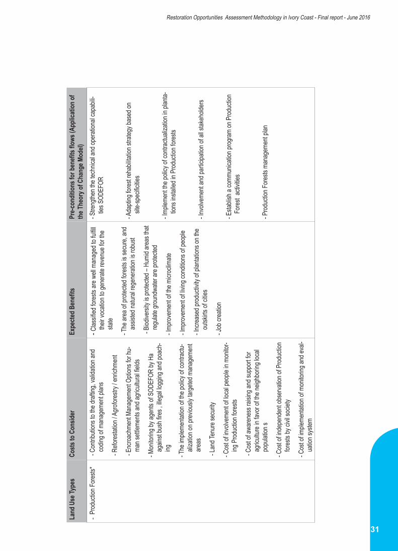
31
Restoration Opportunities Assessment Methodology in Ivory Coast - Final report - June 2016
Land
Use
Type
s Co
sts to
Con
sider
Ex
pecte
d Ben
efits
Pr
e-con
dition
s for
bene
fits fl
ows (
Appli
catio
n of
the T
heor
y of C
hang
e Mod
el)-
Prod
uctio
n Fore
sts*
- Con
tributi
ons t
o the
draft
ing, v
alida
tion a
nd
codin
g of m
anag
emen
t plan
s
- Refo
restat
ion / A
grofor
estry
/ enri
chme
nt
- Enc
roach
ment
Mana
geme
nt Op
tions
for h
u-ma
n sett
lemen
ts an
d agri
cultu
ral fie
lds
- Mon
itorin
g by a
gents
of S
ODEF
OR by
Ha
again
st bu
sh fir
es , i
llega
l logg
ing an
d poa
ch-
ing
- The
imple
menta
tion o
f the p
olicy
of co
ntrac
tu-ali
zatio
n on p
reviou
sly ta
rgeted
man
agem
ent
areas
- Lan
d Ten
ure se
curity
- Cos
t of in
volve
ment
of loc
al pe
ople
in mo
nitor-
ing P
roduc
tion f
orests
- Cos
t of a
waren
ess r
aising
and s
uppo
rt for
agric
ulture
in fa
vor o
f the n
eighb
oring
loca
l po
pulat
ion s
- Cos
t of in
depe
nden
t obs
ervati
on of
Prod
uctio
n for
ests
by ci
vil so
ciety
- Cos
t of im
pleme
ntatio
n of m
onito
ring a
nd ev
al-ua
tion s
ystem
- Clas
sified
fores
ts are
well
man
aged
to fu
lfill
their v
ocati
on to
gene
rate r
even
ue fo
r the
state
- The
area
of pr
otecte
d fore
sts is
secu
re, an
d as
sisted
natur
al reg
enera
tion i
s rob
ust
- Biod
iversi
ty is
protec
ted –
Humi
d area
s tha
t reg
ulate
groun
dwate
r are
protec
ted
- Impro
veme
nt of
the m
icroc
limate
- Impro
veme
nt of
living
cond
itions
of pe
ople
- Incre
ased
prod
uctiv
ity of
plan
tation
s on t
he
outsk
irts of
citie
s
- Job
crea
tion
- Stre
ngthe
n the
tech
nical
and o
perat
ional
capa
bili-
ties S
ODEF
OR
- Ada
pting
fores
t reha
bilita
tion s
trateg
y bas
ed on
sit
e-spe
cificit
ies
- Imple
ment
the po
licy o
f con
tractu
aliza
tion i
n plan
ta-tio
ns in
stalle
d in P
roduc
tion f
orests
- Invo
lveme
nt an
d part
icipa
tion o
f all s
takeh
olders
- Esta
blish
a co
mmun
icatio
n prog
ram on
Prod
uctio
n Fo
rest a
ctivit
ies
- Prod
uctio
n Fore
sts m
anag
emen
t plan

32
Restoration Opportunities Assessment Methodology in Ivory Coast - Final report - June 2016
Land
Use
Type
s Co
sts t
o Co
nsid
er
Expe
cted
Ben
efits
Pr
e-co
nditi
ons f
or b
enefi
ts fl
ows (
Appl
icatio
n of
th
e The
ory o
f Cha
nge M
odel)
Sacre
d For
ests
- Th
e ide
ntific
ation
, loc
aliza
tion a
nd m
appin
g of S
acre
d Fo
rests
- Com
munit
y Cap
acity
Buil
ding w
ith sa
cred f
ores
ts by
civ
il soc
iety o
r othe
r rele
vant
bodie
s- S
uppo
rt for
comm
unity
-bas
ed re
gulat
ions
- Outr
each
and e
stabli
shme
nt of
land c
ertifi
cates
- Enr
ichme
nt re
fores
tation
and c
ommu
nity f
ores
ts , s
a-cre
d for
ests
and c
ommu
nity f
ores
ts de
velop
ment
- Com
munit
y wor
ship
and a
cces
s to c
emete
ries
by th
e pop
ulatio
n are
insu
red
- Natu
ral re
gene
ratio
n is e
ncou
rage
d and
avail
-ab
ility o
f NW
FP fr
om sa
cred f
ores
ts- T
he av
ailab
ility o
f NTF
Ps in
conte
xt of
comm
u-nit
y for
ests
and c
ommu
nities
- Acc
ess t
o lan
d is a
stro
ng in
centi
ve to
plan
t an
d main
tain t
rees
- Stre
ngthe
ns so
cial c
ohes
ion
- Pl
annin
g Sch
emes
terri
tory
- Acc
ess t
o lan
d thr
ough
secu
rity fo
r a st
rong
ince
ntive
to
plant
and m
aintai
n tre
es
- Ide
ntific
ation
and l
ocali
zatio
n of F
S
Priva
te pla
ntatio
ns
Coco
a sys
tems
Coffe
e sys
tems
Sava
nnah
s, wo
od-
lands
and s
econ
dary
fores
ts
- Sec
uring
acce
ss to
land
- Tra
ining
and m
onito
ring o
f phy
tosan
itary
activ
ities
- Esta
blish
ment
of lan
d cer
tifica
tes- T
raini
ng of
farm
ers i
n goo
d agr
icultu
ral p
racti
ces
- Esta
blish
ment
, main
tenan
ce an
d man
agem
ent o
f pr
ivate
planta
tions
by in
dividu
als- T
he di
ffere
nt op
tions
of w
ater c
aptur
e and
supp
ly str
at-eg
ies in
cludin
g irri
gatio
n- M
onito
ring o
f env
ironm
ental
guide
lines
and c
ertifi
catio
n of
agro
fores
try sy
stems
- Pro
ducti
on / n
urse
ry ac
tivitie
s and
proc
urem
ent o
f rar
e an
d valu
able
spec
ies- E
stabli
shme
nt of
land d
evelo
pmen
t sch
emes
- Dem
onstr
ation
plots
and r
esea
rch pr
ogra
ms on
the
integ
ratio
n and
man
agem
ent o
f tree
s in a
grofo
restr
y sy
stems
- Ren
ewal
of pla
ntatio
ns an
d of c
ocoa
and c
offee
or-
char
ds
- The
imple
menta
tion o
f wate
r har
vesti
ng te
chniq
ues
- Inc
reas
e of tr
ees p
lanted
and m
anag
ed by
co
mmun
ities
- Bett
er un
derst
andin
g of th
e use
and a
pplic
a-tio
n of p
estic
ides
- Mod
ificati
on of
micr
oclim
ate of
agric
ultur
al mo
saics
resu
lting f
rom
lower
mor
tality
of tr
ees
due t
o dro
ught.
- Com
binati
on of
mor
e tre
es an
d mor
e rigo
rous
co
ntrol
of fire
s dim
inish
the e
ffect
and i
mpac
t of
bush
fires l
eadin
g to m
ore n
atura
l rege
ner-
ation
- Sys
tems C
ertifi
catio
n ; m
ore m
arke
t and
in-
vestm
ent o
ppor
tunitie
s- I
mpro
ving s
oil qu
ality
and p
rodu
ctivit
y of a
gri-
cultu
ral la
nd- I
mpro
veme
nt an
d dive
rsific
ation
of fa
rmer
s’ inc
omes
- Inc
lusion
of w
omen
, dev
elopm
ent o
f valu
e ch
ains i
n use
of ag
rofore
stry w
ill off
set lo
w pro
ducti
vity a
nd di
minis
h deg
radati
on ,
- Enc
ourag
e you
ng pe
ople
to sta
y on t
he la
nd an
d als
o brea
k the
vicio
us ci
rcle o
f deg
radati
on
-Awa
rene
ss ra
ising
and t
raini
ng of
popu
lation
s
- Pro
vision
of di
verse
and u
seful
nurse
ry pla
nts of
loca
l tre
e spe
cies

33
Restoration Opportunities Assessment Methodology in Ivory Coast - Final report - June 2016
2.6. Analyses of carbon sequestration potential
As part of the assessment of carbon sequestration potential through restoration, certain types of land uses were considered relevant as carbon storage pools, while others were not. Among the major and sub-types of land use; private plantations, coastal areas and sacred forests have not been considered by stakeholders as important carbon reservoirs.
However, wetlands and gallery / riparian forests were considered as potential reservoirs of carbon. In addition, the implementing regulations governing the management of wetlands and gallery forests are being developed under the new Forestry Code. Participants also stressed the need to highlight and separately present the below-ground carbon biomass storage potential of production and protected areas. Stakeholders further stressed the relevance of mapping and locating village-owned forests, private forests, sacred, and community forests.
Stakeholders further stressed the importance of representing the connectivity between large blocks of forests. That, in the case of specialized areas such as abandoned mines, the Ministry of Mines and Water Resources could be a useful collaborator.
Finally, it was widely recognized that updated data analyses on forest cover change in the context of forest and landscape degradation in the Ivory Coast were necessary; and appropriate representations should be developed to represent the different dimensions of degradation.
The following sequence of steps facilitated estimation of the potential for carbon sequestration through restoration of forests and other landscapes assessed as degraded
2.6.1. The approach used
The default carbon sequestration values for each intervention by land use types have been
calculated using the Tier 1 values of the IPCC (CCNUCC, 2006).
In other that the IPCC values may become applicable to this work; the different land use types identified for restoration in Ivory Coast were grouped under two categories:
i. Natural Forests (National Parks and Reserves –NPR in Ivory Coast): these are the results of actions of protection through law enforcement, conservation and natural regeneration.
ii. Planted Forests resulting from reforestation. (Production Forests in Ivory Coast)
The main species in Production Forests used in reforestation are exotics: e.g., Teak, Gmelina and local species used for enrichment: Frake, Framire, Kodibe, etc.
Meanwhile, the estimation of the carbon sequestration potential by restoration intervention within the rural domain comprise mainly of:
i. Natural Forests (on Watersheds, humid zones, gallery and riparian forests)
ii. The creation of plantations in the rural domains using mainly Teak and Cassia pp.
iii. Agroforestry in agriculture mosaics.
Next, the Ivory Coast was divided into two major bio-climatic zones adapted to the nomenclature used by the IPCC, comprising :
i. Humid tropical forests encompassing all forests and pre-forest zones (coastal zones, forest zones)
ii. Dry Tropical Forests: zones extending into the savannah areas.
The carbon values are thus developed to align with the bio-climatic domains and associated with the different land use types.

34
Restoration Opportunities Assessment Methodology in Ivory Coast - Final report - June 2016
The values are calculated by first estimating the amount of biomass per hectare that could be captured through restoration, by intervention type leading to that relevant new land cover type. The amount of carbon derived, is thus estimated according to the following equations:
CAB= (ABG+BGB) x CF
Where:CAB= Carbon stocks in living biomass; tons of carbon (tC)AGB= Above-ground biomass; ton (t)BGB= Below-ground biomass; ton (t)CF: Conversion factor (0,49 tC/t default value of Carbon contained in a unit volume of biomass).
AGB= V x BCEFWhere: V= Commercial value of a Tree (m3); BCEF: conversion factor and biomass expansion of the trunk to the total aboveground biomass; Equals 9 for tropical plantations (GIEC, 2006). BGB = AGB x RWhere: R = ratio linking root biomass to aboveground biomass of 0.2 to tropical rainforests and 0.56 for tropical dry forests (GIEC, 2006).
CO2 = CAB x 44/12The amount of carbon sequestered is multiplied by the area of the restored land (previously evaluated as extent of degradation) into the appropriate vegetation (New Land Cover) type
Table 6: Default values of above-ground biomass of forests
Data source: IPCC 2006.NB: On the corresponding Dense Tropical Forest numbers were applicable
ESTIMATION OF TIER 1 BIOMASS VALUE: VALUES ARE APROXIMATESCl ima te Domain
Ecological Zone Above ground biomass of
natural forests
(tons m.s./ha)
Above ground biomass of
planted forests
(tons m.s./ha)
Net growth in above ground
biomass of natural forests
(tons m.s./ha)
Net growth in above ground
biomass of planted forests
(tons m.s./ha)
Tropical
Dense tropical forests 300 150 7 15Deciduous humid tropical forests
180 120 5 10
Dry Tropical Forests 130 60 2.4 8Shrubby Tropical forests
70 30 1 5
Tropical Montagne forests
140 90 1 5

35
Restoration Opportunities Assessment Methodology in Ivory Coast - Final report - June 2016
Table 7: Corresponding land use types; Ivory Coast and IPCC categorizations
Land Use Types Restoration Intervention Expected Land Cover Type IPCC category
Parks and ReservesIntegral protection Previous Forest Cover Type
Forest Land Remaining ForestNatural Regeneration Control of Bush Fires
Main Watershed ProtectionPrevious Forest Cover Type Forest Land Remaining Forest
Natural Regeneration
Agroforestry
Planted Forests
Land converted to Forest LandReforestation
Forest Land Remaining ForestEnrichment
Control of Bush Fires Previous Forest Cover Type
Securing Tenure Previous Forest Cover Type / Planted Forest Mixed Forests
Coastal Erosion Control Planted Forests Land converted to Forest Land
Control of Bush Fires Previous Forest Cover Type Forest Land Remaining Forest
Production Forests
Protection Previous Forest Cover Type Forest Land Remaining Forest Natural RegenerationAgroforestry
Planted Forests
Land converted to Forest LandReforestation
Forest Land Remaining Forest EnrichmentControl of Bush Fires EnrichmentControl of Bush Fires Previous Forest Cover Type
Savannah
Agroforestry Cultures Land converted to Forest Land Reforestation Planted Forests Land converted to Forest Land
Control of Bush Fires Previous Forest Cover Type Forest Land Remaining Forest
Rural Domain : Cocoa, Coffee, Oil Palm, Cashew
Agroforestry Mixed Tree-crop System Cultivated land remaining cultivated land
Securing Tenure Planted Forests Cultivated land remaining cultivated land
CO2 estimates per ha were carried out according to the type of land use land cover type and eco-climatic zones. Grouped IPCC default values as presented in Table 8 were used.
2.6.2. Estimation of the carbon sequestration potential of restoration
Carbon stocks for above and below ground biomass pools are estimated under IPCC
category and matched with different Land Use Types; Restoration interventions and expected land cover type after restoration. Table 7 below summarizes the process;

36
Restoration Opportunities Assessment Methodology in Ivory Coast - Final report - June 2016
Table 8: Carbon dioxide sequestration potential of identified land use systems
Table 9:Estimation of corresponding minimum carbon dioxide sequestration potential
NB: Land use types applicable and used are highlighted
Corresponding land use type
(Ivory Coast)
Ecological zone (IPCC)
tCO2 (tCO2/ha)(i)
Natural Forests
(ii)
Planted Forests
(iii)
AgroforestryForest Zones Dense Forest 708.93 354.47 75.24Peri-Forests Deciduous forest 372.58 248.39 75.24Wooded Savannah Dry Forest 287.02 132.47 75.24Shrub Savannah Scrubland 169.04 72.44 53.22
Restoration interventions in Côte d’Ivoire
Ultimate Land Cover Category
Minimum Priority Area for
Restoration (ha)
CO2 Sequestration
Potential (tCO2)Protection and Natural Regeneration
of Parks and Reserves
(i)
Natural Protection Forests 97,943 69, 434,730.99
Reforestation and Enrichment Plant-ing (Production and Planted Forests)
(ii)
Production Forests and Plantations 556,298 197, 190,952.1
Rural Domain (Agroforestry)
(iii)Cropping Systems 4, 423, 431 332, 818,948.4

37
Restoration Opportunities Assessment Methodology in Ivory Coast - Final report - June 2016
2.7.
Civil
Soc
iety i
n th
e pro
cess
of r
esto
ratio
n in
the I
vory
Coa
st
Land
Use
Type
s Ca
uses
of De
grada
tion
Interv
entio
ns
Roles
of CS
Os
Prop
osed
Strat
egies
Ta
rgeted
Entiti
esCo
ordina
tion
Natio
nal
Park
s and
Re
serv
es *
(NPR
)
-Plan
tatio
ns o
f cas
h cr
ops
(coc
oa, c
offe
e , o
il palm
, ca
shew
)-F
arm
s and
hou
ses,
-poa
ching
,-B
ush
fires
-Mini
ng
Man
agem
ent o
f peo
ple
inside
and
out
side
park
s and
re
serv
es
-Help
the
reloc
ation
an
d m
anag
emen
t of
peop
le ou
tside
par
ks a
nd
rese
rves
for m
ore
dura
ble
resto
ratio
n.
-Lob
bying
(Nat
ional
and
local
levels
)-S
ensit
izatio
n-C
omm
unica
tion
-pro
mot
ion o
f par
ticipa
tory
ap
proa
ches
- Dev
elop
eco-
tour
ism- M
obiliz
ing fin
ancia
l and
te
chnic
al pa
rtner
s
- Sta
te
(Mini
stries
) riv
erine
po
pulat
ions (
ins
ide p
arks
and
re
serv
es)
–Elec
ted
offic
ials
-NGO
Plat
form
for
man
grov
e-T
he D
raftin
g of
po
licies
Man
grov
es,
coas
tal
area
s and
hu
mid
zone
s
Mini
ng
Bush
fires
Woo
d ex
ploita
tion
Soil d
istur
banc
es
-Was
te w
ater
-Silti
ng a
nd cl
oggin
g-up
of
wate
r way
s.
-Effe
ctive
supe
rvisi
on o
f a
mini
mum
of
resto
ratio
n pr
iority
-Rec
onsti
tutio
n of
Man
grov
es
at th
e co
ast
-Reg
ister
Man
grov
e sit
es
on th
e lis
t of R
AMSA
R sit
es
(wet
lands
of in
tern
ation
al im
porta
nce
-Cre
ate
mar
ine p
arks
-Set
ting
up o
f man
grov
e m
anag
emen
t com
mitte
es in
co
asta
l villa
ges a
nd m
ake
them
ope
ratio
nal
-Cre
ating
refo
resta
tion
and
wood
ene
rgy m
anag
emen
t-u
se o
f was
te fr
om co
conu
t tre
es a
s coo
king
ener
gy
-Lob
bying
(Nat
ional
and
local)
-Sen
sitiza
tion
-Com
mun
icatio
npa
rticip
ator
y -Ap
proa
ches
-Eco
-tour
ists
(Cre
ation
of e
colog
ical
tour
s, ob
serv
ation
plat
form
of
nat
ure)
-Tra
ining
of t
ouris
t guid
es
on b
iodive
rsity
- Sta
te
(Mini
stries
) riv
erine
po
pulat
ions (
ins
ide p
arks
and
re
serv
es)
–Elec
ted
offic
ials
Loca
l man
agem
ent
-Com
mitte
es
-NGO
Plat
form
for
man
grov
e-T
he D
raftin
g of
a
polic
ies
Galle
ry a
nd
ripar
ian
fore
sts
-Tim
ber o
pera
tions
for w
ood
ener
gy,
-Plan
tatio
ns-E
xploi
tatio
n of
qua
rries
and
gr
avel
pits
Imple
men
tatio
n of
a
man
agem
ent p
lan fo
r we
tland
s and
gall
ery f
ores
ts-A
pplic
ation
Of le
gislat
ion
and
law e
nfor
cem
ent a
t the
pe
rimet
er o
f exp
loita
tion
- Help
resto
re th
e ba
nks,
wate
r and
man
grov
e ec
osys
tem
s
-Lob
bying
(Nat
ional
and
local)
-Sen
sitiza
tion
-Com
mun
icatio
n-P
artic
ipato
ry a
ppro
ache
s
- Sta
te
(Mini
stries
) riv
erine
po
pulat
ions (
ins
ide p
arks
and
re
serv
es)
–Elec
ted
offic
ials
Train
ing a
nd su
ppor
t to
loca
l com
mitte
es

38
Restoration Opportunities Assessment Methodology in Ivory Coast - Final report - June 2016
Sacr
ed
For
ests
Bush
fires
and
ille
gal e
xploi
tatio
n
Supp
ort t
o co
mm
unity
-ba
sed
by-la
ws
-Sen
sitiza
tion
-Mon
itorin
g
-Rep
ortin
g of
tran
sgre
ssor
s
-Sup
port
to co
mm
unitie
s
-Stre
ngth
ening
ca
pacit
y of
com
mun
ities a
nd
CSO
Loca
l pop
ulatio
ns -I
nvolv
emen
t of lo
cal
popu
lation
s, vil
lager
s, cu
stodia
ns o
f loca
l cus
tom
s, Yo
uths
and
Wom
en.
build
ing ca
pacit
ies o
f co
mm
unitie
s with
sacr
ed
fore
sts
- Stu
dies
-Sup
port
and
stren
gthe
ning
capa
cities
of c
omm
unitie
s wi
th p
rote
cted
fore
sts
Prom
otion
of
com
mun
ity-b
ased
bio
diver
sity
cons
erva
tion
Villa
ge-c
omm
unity
-Elec
ted
offic
ials
-Mini
stry o
f For
ests
-Sup
port
com
mun
ity
leade
rship
in th
e m
anag
emen
t of
clas
sified
fore
sts.
Exte
nsion
and
es
tabli
shm
ent o
f land
ce
rtific
ates
inter
vent
ion a
t Sta
te le
vel to
low
er co
sts /
subs
idies
-org
aniza
tion
of
mob
ile co
urts
villag
e-co
mm
unity
-Sta
te
-Lan
der o
wner
.
-Sup
ervis
ion o
f Com
mun
ities
-NGO
s plat
form
s
Assis
ted
natu
ral
rege
nera
tion
Assis
ted
natu
ral
rege
nera
tion
-Inve
ntor
y of s
pecie
s an
d ev
aluat
e pr
otec
tion
need
s
Loca
l com
mun
ity
Villa
ge le
ader
s
NGO
Plat
form
Supp
ort t
o loc
al co
mm
unitie
s.

39
Restoration Opportunities Assessment Methodology in Ivory Coast - Final report - June 2016
Land
Use
Typ
es
Caus
es o
f De
grad
ation
In
terv
entio
ns
Roles
of C
SOs
Prop
osed
Stra
tegie
s Ta
rget
ed E
ntitie
s
Priva
te p
lanta
tions
Ag
eing
orch
ards
,
Exce
ss
Phyto
sanit
ary
actio
ns
Drou
ght
Illega
l logg
ing ,
Woo
d En
ergy
ex
ploita
tion,
Eros
ion
Dese
rtific
ation
Bush
fires
Secu
ring
acce
ss to
land
inter
vent
ion a
t Sta
te le
vel to
low
er co
sts /
subs
idies
-Org
aniza
tion
of m
obile
cour
ts
-Mob
ilizat
ion o
f Tec
hnica
l and
fin
ancia
l par
tner
s
NGO
Plat
form
s
Coco
a sy
stem
sTr
aining
and
mon
itorin
g of
phy
tosa
nitar
y pr
actic
es-In
volve
men
t in tr
aining
and
fo
llow-
up o
f ph
ytosa
nitar
y pr
actic
es
-Rep
ortin
g de
fault
ers
-adv
ocac
y
parti
cipat
ory a
ppro
ache
s
Coffe
e sy
stem
s
Sava
nnah
s, wo
odlan
ds
and
seco
ndar
y for
ests
Rene
wal o
f coc
oa a
nd co
ffee
plant
a-tio
ns a
nd A
grof
ores
try
Invo
lvem
ent o
f Com
mun
ities
and
NGOs
Cr
eatio
n of
plan
tatio
ns o
f fas
t-gro
wing
tre
esIn
volve
men
t of N
GO,
mon
itorin
g an
d re
porti
ng o
f de
fault
ers
-adv
ocac
y
parti
cipat
ory a
ppro
ache
s
and
enga
gem
ent w
ith te
chnic
al an
d fin
ancia
l par
tner
s
Mini
ng
Zone
s
Imple
men
t wat
er h
arve
sting
tech
nique
s
Invo
lvem
ent o
f Com
mun
ities
and
NGOs
and
repo
rting
of
defa
ulter
s
High
light
ing o
f spe
cifica
tions
on
artis
-an
al m
ines a
nd m
easu
res i
n th
e fig
ht
again
st bu
shfir
es
Prom
otion
of c
ocoa
-gro
wing
certi
fica-
tion,
coffe
e pla
nting
cash
ew, R
ubbe
r an
d Pa
lm O
il an
d Agr
ofor
estry

40
Restoration Opportunities Assessment Methodology in Ivory Coast - Final report - June 2016
3. CONCLUSION
The process of implementing the ROAM in the Ivory Coast has been a revelation, and has demonstrated the importance
of being guided by a robust methodology. The notion of restoring degraded forests and landscapes evokes numerous perceptions; each strongly influenced by own-experiences of stakeholders. It is therefore possible in such a context to introduce a methodology like the ROAM as the object of innovation.
In this work, the links between the forest restoration process and degraded landscapes were simultaneously, a sensitive issue as well as an opportunity. It was an opportunity in that, it would assure and reinforce the links between national and other global processes such as REDD +, the CBD and the Aichi Target 15 Objectives; and the fight against desertification.
On the other hand, landscape restoration is not simply driven by its activity content at national level; but by its international stature, and requires institutional anchorage. Incidentally, while MINEF is directly responsible for numerous forestry activities in the Ivory Coast, another Ministry MINEDD is responsible for the related Conventions covering landscape restoration. This was a sensitive issue which had to be carefully balanced in the process of implementing ROAM in the Ivory Coast.
To this end, the transparency with which the inception process was conducted helped strengthen the role of MINEF although the final validation of results became by default, the responsibility of the Ministry of Environment and Sustainable Development (MINEDD). MINEDD is the statutory leader of the international conventions related to the restoration of degraded landscapes in the Ivory Coast. This role of MINEDD also helped influence the analyses of the evaluation process to not be limited to production forests alone (under the purview of MINEF), but to be extended to cover different land use types other than production forests; e.g. watersheds, gallery forests, humid zones and other protection forests more within the agenda of MINEDD.
This evaluation has further highlighted the complexities in the perceptions of degradation which is a notion not given to a simplistic cause-effect relationship; but to a multiplicity of functions, land use management costs, benefits, productivity, change and utility of systems under management by different actors. This also explains why there is a multiplicity of actors; State and non-state, involved in the identification process of the causes, effects, interventions, costs and benefits of restoration.
There are comprehensive policies, legal and institutional frameworks existing or under development, and supporting landscape restoration in the Ivory Coast. Nevertheless, they must be applied on a case-by-case basis, especially where they have a good chance of strengthening land tenure security, one key area identified by all stakeholders to be a major constraint when it comes to investments in tree and trees systems in the long-term.
In terms of opportunities and priorities for restoration, according to the ROAM, there is a significant difference between the two. However, due to real world socio-economic complexities, criteria for separating opportunities from priorities do not often agree with stakeholder aspirations and decision-making flexibilities. Especially in areas under official texts (parks, reserves and production forests) and other, with high levels of human activity and more secure tenure. In these two categories in particular, the application of restoration criteria either tends to be rigid (based on law) or subject to decision-making of individuals or groups of actors (e.g., based on tenure in urban areas). Therefore, although opportunity for restoration tends often to be lower than priority, stakeholder preferences in the Ivory Coast influenced this relationship to the extent that, both opportunity and priority evolved to be almost identical.
For this reason, and in the case of the Ivory Coast with extensive levels of degradation, an ambitious restoration program bringing together opportunities and priorities in the first instance can be considered as justified. This is further

41
Restoration Opportunities Assessment Methodology in Ivory Coast - Final report - June 2016
reinforced by the fact that, due to the age of available spatial datasets, the exact extent, even of deforestation could not be determined. However, through stratification of land use types, including qualitative descriptions of different dimensions of degradation in these sub categories of land uses, we were confident that errors in the national level data have been kept to a minimum; and the area to be restored as priority is a truer reflection of the situation of degraded landscapes in Ivory Coast.
The identification and stratification of the different types of degraded land uses to be restored was also very helpful in the process of qualitative analysis of the costs and benefits of restoration. The key degradation issues and challenges in the land use systems were however, not easy to determine quantitatively by the stakeholders involved in their use. The characterization of what needed to be done and the potential benefits expected were easier to establish. Furthermore, quantitative analyses of costs and benefits could not have been meaningful or realistic at this stage. Firstly, there is lack of quality data. Secondly, the current dynamic processes, unfinished development plans and high expectations would render the costs of restoration not only inhibitory (despite benefits), but probably impracticable if the envisaged benefits are too intangible and or expected to accrue far into the future. However, the application of models to help define the potential costs and benefits of restoration is still valid. Nevertheless, the administrative costs of a model must be justified, more as a way to frame the parameters of managing the recommendations, even if these would still remain too uncertain for a developing country like Ivory Coast.
The analysis of carbon sequestration potential draws directly from the estimation of areas determined as ‘degraded’; by land use type and by intervention. As part of this evaluation, the default values provided by the IPCC were used. However in the future it will be more appropriate to use the values developed by local researchers as they are applicable to specific land use systems, as identified and described in a stratified approach.
The advantage of this stratified approach is that, it strengthens the possibility of capturing many more subtle variations in carbon pools; thereby rendering the estimated amount of carbon potentially sequestered, more accurate, and better aligned with the multiple requirements of the development processes in the Ivory Coast.
Although potentially more costly to implement, restoration based on a stratified approach can also be useful in programs to monitor changes in carbon stocks at local smallholder levels important for better national carbon accounting and governance.
Finally, this process started with facilitation by civil society organizations and their possible roles in the process. The evaluation process that ensued identified the roles of different groups and categories of Civil Society; including youth, women and vulnerable groups. Through their different strategies, by type of land use and by investment, the participation of civil society is likely to be more systematic, easy to monitor and therefore, strengthen.

Restoration Opportunities Assessment Methodology in Ivory Coast - Final report - June 2016
1- IUCN and WRI (2014) Guide to the Restoration Opportunities Assessment Methodology (ROAM): Assessing forest landscape restoration opportunities at the national or sub national. Working paper (Road-test edition), Gland, Swierland: IUCN. 125pp
2- BNETD (2004), the Land Use Map of the Ivory Coast
3- IPCC (2006), 2006 IPCC Guidelines for National Greenhous Gas Inventories, Agriculture, Forestry and Other Land Uses, Volume 4. (http://www.ipcc-nggip.iges.or.jp/public/2006gl/french/vol4.html Accessed July 07 2016)
REFERENCES
42
Restoration Opportunities Assessment Methodology in Ivory Coast - Final report - June 2016

IUCN offices in West and Central Africa
IUCN - Burkina FasoPo.Box: 3331 Ouagadougou
Tel.: +226 50 32 85 01Fax : +226 50 30 75 61
E-mail : [email protected]
IUCN - CameroonPo.Box: 5 506 YaoundéTel.: +237 222 21 64 96
Fax : +237 222 21 64 97E-mail : [email protected]
IUCN - Guinée BissauApartado 23, Bissau 1031
Tel.: +245 20 12 30Fax : +245 20 11 68
E-mail : [email protected]
IUCN - MaliPo.Box: 1567 BamakoTel.: +223 20 22 75 72
Fax : +223 20 23 00 92E-mail : [email protected]
IUCN - MauritaniePo.Box: 4167 Nouakchott
Tel.: +222 525 12 76Fax : +222 525 12 67
E-mail : [email protected]
IUCN - NigerPo.Box: 10933 NiameyTel.: +227 20 72 40 28Fax : +222 525 12 67
E-mail : [email protected]
IUCN - Democratic Republic of Congo43, avenue Colonel Ebeya
Immeuble CAP IMMOTel.: +243 81 79 47 711
E-mail : [email protected]
IUCN - SénégalAvenue Cheick Anta Diop
2rd Etage B.P: 32 15 DakarTel.: +221 33 869 02 81
Fax : +221 33 824 92 46E-mail : [email protected]
IUCN - Project Office GhanaPo.Box M239 Accra
Tel.: +233 021 66 46 54Fax : +233 021 66 64 16
E-mail : [email protected]

Restoration Opportunities Assessment Methodology in Ivory Coast - Final report - June 2016
INTERNATIONAL UNIONFOR CONSERVATION OF NATURE
Regional officefor West and Central Africa01 Po. Box 1618 Ouagadougou 01Burkina FasoPhone: + 226 5036 4979 + 226 5036 4895E-mail : [email protected]/paco