operational numerical guidance for noaa weather and … · 2014-02-21 · prowess 2014 forecast...
TRANSCRIPT

PROWESS 2014 1
Dr. William. M. Lapenta Director
National Centers for Environmental Prediction
NOAA/NWS
J. C. Derber, G. DiMego, M. B. Ek, M. Iredell, S. Moorthi, V. Tallapragada,
H. L. Tolman, S. Saha, and Y. Zhu
NCEP
Operational Numerical Guidance for
NOAA Weather and Climate Services

PROWESS 2014
NOAA Operational Numerical Guidance
Supports the Agency Mission
– Numerical Weather Prediction at NOAA
Required for agency to meet service-based metrics
– National Weather Service GPRA* Metrics (* Government Performance & Results Act)
Hurricane Track and Intensity
Winter Storm Warning
Precipitation Threat
Flood Warning
Marine Wind Speed and Wave Height
– Operational numerical guidance: Foundational tools used by government, public and private
industry to improve public safety, quality of life and make
business decisions that drive U.S. economic growth
2
Lead Time
and
Accuracy!

PROWESS 2014
Forecast
Uncertainty
Minutes
Hours
Days
1 Week
2 Week
Months
Seasons
Years
Seamless Suite of Operational
Numerical Guidance Systems
Fo
rec
as
t L
ea
d T
ime
Warnings & Alert
Coordination
Watches
Forecasts
Threats
Assessments
Guidance
Outlook
Benefits
•North American Ensemble Forecast System •Climate Forecast System
•Short-Range Ensemble Forecast
•Global Forecast System
•North American Mesoscale
•Rapid Refresh
•Dispersion (smoke)
•Global Ensemble Forecast System
• Regional Hurricane • (HWRF & GFDL)
• Waves • Global Ocean
• Space Weather
Spanning Weather and Climate
• Tsunami
• Whole
Atmosphere
• HRRR
• NMME
• NLDAS
• Wave Ensemble
• Bays
• Storm Surge
•Global Dust
•Fire Wx
3
• Air Quality

PROWESS 2014
Regional Hurricane
GFDL WRF-NMM
WRF(ARW, NMM) NMMB
Climate Forecast System (CFS)
Short-Range Ensemble Forecast
NOAA’s Operational Numerical
Guidance Suite (Jan 2014)
GFS, MOM4, NOAH, Sea Ice
North American Ensemble Forecast System
GEFS, Canadian Global Model
Dispersion HYSPLIT
Air Quality
CMAQ
Regional NAM
NMMB NOAH
3D
-VA
R
DA
Regional Bays •Great Lakes (POM)
•N Gulf of Mexico (FVCOM) •Columbia R. (SELFE) •Chesapeake (ROMS)
•Tampa (ROMS) •Delaware (ROMS)
Space Weather
ENLIL 4
North American Land Surface Data Assimilation
System NOAH Land Surface Model
Global Spectral NOAH
3D
-En
-Var
D
A
Global Forecast System (GFS)
3D
-VA
R
DA
3D
-VA
R
DA
WRF ARW
Rapid Refresh
3D
-VA
R
DA
Waves WaveWatch III
Ocean HYCOM
Ecosystem EwE
Global Ensemble Forecast System (GEFS)
21 GFS Members
ESTOFS ADCIRC
SURGE SLOSH
P-SURGE SLOSH
WRF ARW
3D
-VA
R
DA
High Resolution RR
NEMS Aerosol Global Component (NGAC)
GFS & GOCART
WRF(ARW, NMM) & NMMB
High Res Windows
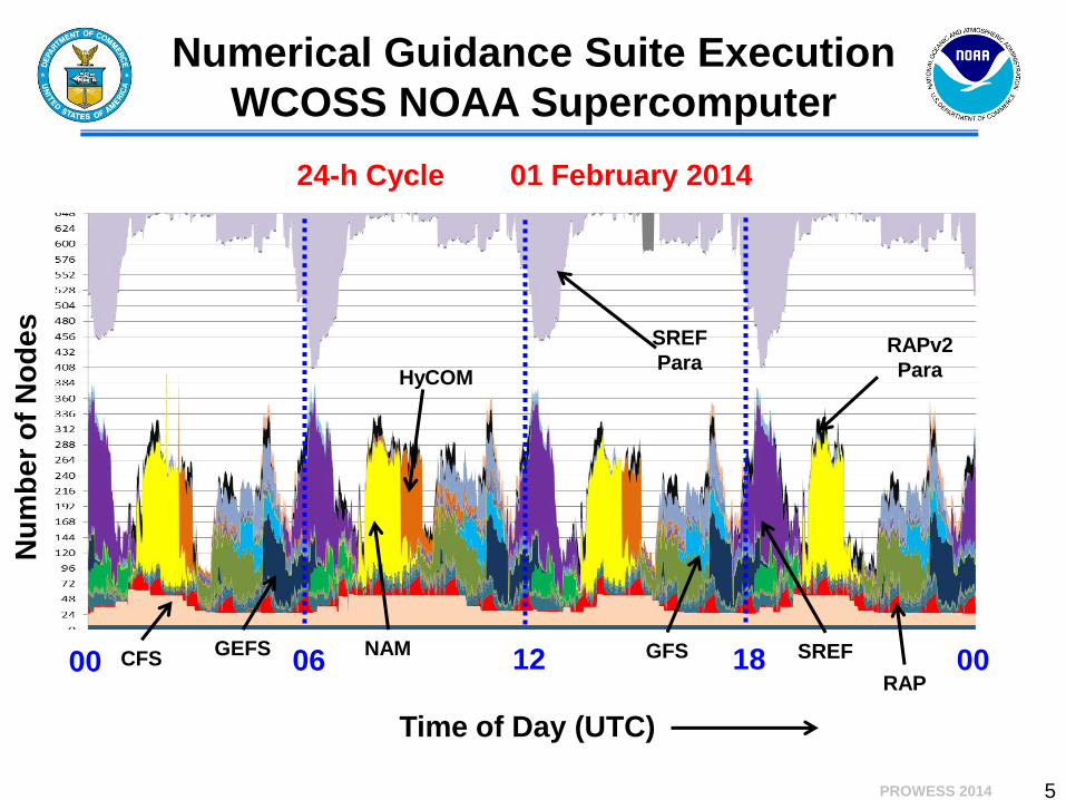
PROWESS 2014 5
24-h Cycle 01 February 2014
Numerical Guidance Suite Execution
WCOSS NOAA Supercomputer
Nu
mb
er
of
No
de
s
Time of Day (UTC)
00 06 12 18 00 CFS NAM GFS GEFS SREF
HyCOM
SREF
Para RAPv2
Para
RAP

PROWESS 2014 6
Forcing Factors Shaping NOAA
Operational Numerical Guidance
Emerging Requirements Weather Ready Nation
High impact events
Weather to climate—seamless suite of guidance and products
Science and Technology Advances Observing systems
High performance computing
Data dissemination
Numerical Guidance Systems Data assimilation (methodology)
Modeling (physics, coupling & dynamics)
Ensembles (construction—initialization, membership, etc.)
Intelligent post processing
Predictability convective systems
Seasonal to interannual

PROWESS 2014 7
The NOAA Modeling Strategy…
High Level Perspective Moving away from the “model of the day”
Continue to pursue multi-model approach to ensembles
• Don’t forget: ensemble systems only as good as the modeling
system it is built from
Priorities for deterministic development are clear:
1. Data assimilation (methodology and observations)
2. Model physics
Why do we continue to underplay this important part of the
enterprise?
Clouds, microphysics, radiation, land, ocean, ice,
aerosols….includes coupling
3. Resolution—horizontal and vertical
4. Dynamic core
Must consider advanced HPC technologies but don’t forget about
the science
Regional systems shift to convection permitting applications
NOAA encouraged to consider unified modeling approach
(UCACN)

PROWESS 2014
System Current Q4FY14 FY18
GDAS
80 member @ T254
Eulerian (55 km)
80 member @ T574 SL (35
km)
4DHybrid 80 member @
T1148 SL (17 km)
Analysis @ T574
Eulerian (27 km) using
T254 Eulerian ensembles
Analysis Increment @ T574
SL (27 km) using T574 SL
ensembles
Analysis Increment @T1148
SL (17 km) using T1148 SL
ensembles
64 Vertical Levels 64 Vertical Levels 128 Vertical Levels
Additional Obs., Improved
radiative transfer, many
smaller changes, uses GFS
model below
Additional Obs., Cloudy
Radiances, Improved QC and
ob. Errors, Ensemble
Hurricane relocation
System Current Q4FY14 FY18
GFS
T574 Eulerian (27 km) to
7.5 days
T1534 SemiLagrangian (13
km) to 10 days
T2000 (10 km) to 10 days
T254 Eulerian (55 km)
days 7.5 to 16
T574 SL (35 km) days 10 to
16
T1148 (17 km) days 10 to 16
64 Vertical Levels 64 Vertical Levels 128 Vertical Levels
Global Forecast System Evolution: 2014 to 2018

PROWESS 2014
Real Time Ocean Forecast System Implemented 24 October 2011
9
• RTOFS Global is the first global eddy-resolving ocean forecast system at NOAA/NCEP
• 1/12 degree HYCOM (HYbrid Coordinate Ocean Model)
• 6-day forecasts initialized at 00 UTC
• 32 vertical hybrid layers (isopycnal in the deep, isolevel in the mixed layer and sigma in shallow waters)
• Initialization: MVOI scheme (NCODA) developed by the US Navy
• Forced with the GFS surface fluxes of radiation, precipitation and momentum.
Thanks to the NAVY for
partnering with NOAA and
making HYCOM available

PROWESS 2014
Operational Wave Model
Configurations
10
Multi-1 global model.
Multi-2 global hurricane model.
Great lakes with 2 staggered cycles
(NAM driven and NDFD driven)
NCEP wave ensemble system
Combined FNMOC/NCEP wave
ensemble system
Nearshore Wave Prediction System
(Alpha testing)

PROWESS 2014 11
• Facilitated by the NOAA Climate Test Bed
• NMME as a Modeling Test-Bed • Seasonal to Interannual Time Scales
• Predictability Research: e.g., South East US Drought
• Model Evaluation and Development
• Initialization Strategies: e.g., Land, Ocean
• Fosters interaction between research and operations
• Provides experimental guidance products to Climate Prediction Center
• Participating Organizations: • University of Miami - RSMAS
• National Center for Atmospheric Research (NCAR)
• Center for Ocean--‐Land--‐Atmosphere Studies (COLA)
• International Research Institute for Climate and Society (IRI)
• Canadian Meteorological Centre (CMC) • NASA – GMAO
• NOAA/NCEP/EMC/CPC
• NOAA/GFDL
• Princeton University
• University of Colorado (CIRES
National Multi-Model
Ensemble (NMME) Project
Data are available at: http://iridl.ldeo.columbia.edu/SOURCES/.Models/.NMME/

PROWESS 2014 12
Model Hindcast
Period
No. of
Member
Arrangement of
Members
Lead
(months)
Model
Resolution:
Atmosphere
Model
Resolution:
Ocean
Reference
NCEP-CFSv2 1982-2010 24(20)
4 members
(0,6,12,18Z)
every 5th day
0-9 T126L64 MOM4 L40
0.25 deg Eq
Saha et al.
(2010)
GFDL-CM2.1 1982-2010 10 All 1st of the month
0Z 0-11 2x2.5deg L24
MOM4 L50
0.30 deg Eq
Delworth et
al. (2006)
CMC1-
CanCM3 1981-2010 10
All 1st of the month
0Z 0-11
CanAM3
T63L31
CanOM4 L40
0.94 deg Eq
Merryfield
et al. (2012)
CMC2-
CanCM4 1981-2010 10
All 1st of the month
0Z 0-11
CanAM4
T63L35
CanOM4 L40
0.94 deg Eq
Merryfield
et al. (2012)
NCAR-
CCSM3.0 1982-2010 6 All 1st of the month 0-11 T85L26
POP L40 0.3
deg Eq
Kirtman and
Min (2009)
NASA-
GEOS5 1981-2010 11
4 members every 5th
days; 7 members on
the last day of the
previous month
0-9 1x1.25deg L72 MOM4 L40
1/4 deg at Eq
Rienecker et
al. (2008)
* This slide is by courtesy of Huug Vandendool, Qin Zhang, and Emily Becker.
Current NMME Models

Benefits of NMME
to Contributing Agencies • A real-time prediction platform for model diagnosis and
evaluations of their perspective model(s) with comparison of
their models for both weather and monthly/seasonal time scales
in an operational setting
• Enhanced coordination and collaboration on climate
predictability and prediction studies including guidance for
their model evaluation and development efforts;
• A platform to demonstrate broader impacts of their supported
research advances on decision makers and end-users who
depend on climate information at ISI time scales, and
• Publicly available NMME data for research and users
community including young scientists.

PROWESS 2014 14
NAM • Implemented 18 October 2011
• NEMS based NMM
• Parent remains at 12 km
• Multiple Nests Run to ~48hr – ~4 km CONUS nest
– ~6 km Alaska nest
– ~3 km HI & PR nests
– ~1.5-2km DHS/FireWeather/IMET possible
Rapid Refresh • Scheduled implementation 20 March 2012
• WRF-based ARW
• Use of GSI analysis
• Expanded 13 km Domain to include Alaska
• Experimental 3 km HRRR
RUC-13 CONUS domain
WRF-Rapid Refresh domain – 2010
Original CONUS domain
Experimental 3 km HRRR
NCEP Mesoscale Modeling
for CONUS:

Only 14 cases at 120 hr
verified for 2013
NCEP Operational HWRF showing systematic improvements in intensity forecasts
Intensity Forecast Errors from Operational HWRF 2008-2013
15

16
Advancements to Operational HWRF – Transition to NMM-B/NEMS Multi-Scale Modeling System
• NCEP/AOML Collaborative effort supported by OAR
Sandy Supplemental High Impact Weather Prediction
Project (HIWPP) and leveraged by NOAA’s HFIP support
• Take advantage of NMMB in NEMS infrastructure for
developing next generation global-to-local-scale
modeling system for tropical cyclone forecasting needs
and for comprehensive solutions for landfalling storms
• Planned development, testing and evaluation leading to
potential transition to operations in the next 3-5 years
Scientific advancements include:
• Scale aware and feature aware
physics for high-resolution
domains and for multi-scale
interactions
• Advanced techniques for inner
core data assimilation with use all
available aircraft recon data
including TDR, FL, SFMR, and
satellite radiance data
• High-resolution ensembles for
prediction of RI/RW
• Enhanced land-air-sea-wave-
hydrology coupled system
16

PROWESS 2014 17
• The GFS must: Provide skillful guidance for all NOAA operational applications
Demonstrate at least the computational efficiency of the current GFS
Provide the flexibility to meet future demands
• Candidate Models Currently Under Development
GFS Global Spectral Model (GSM--NCEP)
Non-Hydrostatic Multiscale Model (NMM--NCEP)
Non-hydrostatic Flow Following Icosahedral Model (NIM--ESRL)
Cubed-Sphere Finite Volume (HiRAM--GFDL)
Model for Prediction Across Scales (MPAS--NCAR)
• NCEP Committed to global spectral model through 2018
Viable candidate MUST emerge with acceptable level of risk to opreations
Cycles with data assimilation system and robust physics package
Computationally efficient (conventional and advanced architectures)
Applicable to medium range and ISI
Next Operational Global Model?
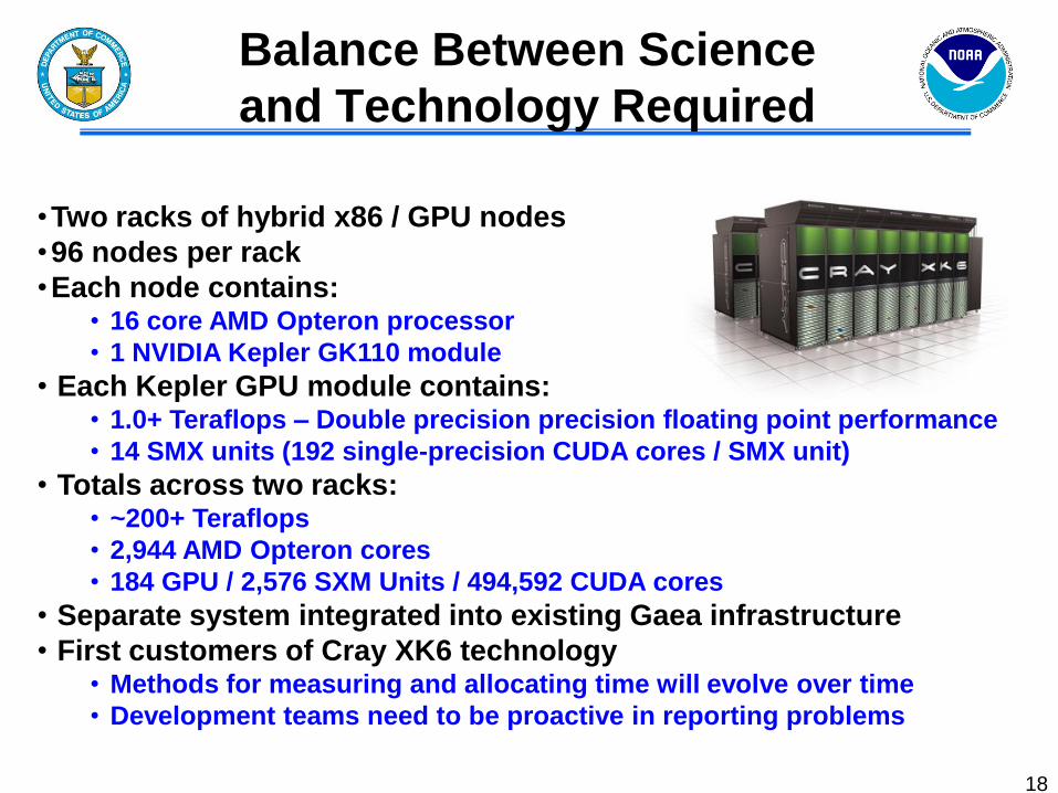
•Two racks of hybrid x86 / GPU nodes
•96 nodes per rack
•Each node contains: • 16 core AMD Opteron processor
• 1 NVIDIA Kepler GK110 module
• Each Kepler GPU module contains: • 1.0+ Teraflops – Double precision precision floating point performance
• 14 SMX units (192 single-precision CUDA cores / SMX unit)
• Totals across two racks: • ~200+ Teraflops
• 2,944 AMD Opteron cores
• 184 GPU / 2,576 SXM Units / 494,592 CUDA cores
• Separate system integrated into existing Gaea infrastructure
• First customers of Cray XK6 technology • Methods for measuring and allocating time will evolve over time
• Development teams need to be proactive in reporting problems
Balance Between Science
and Technology Required
18

PROWESS 2014 19
Thanks for Your Time.
Questions?