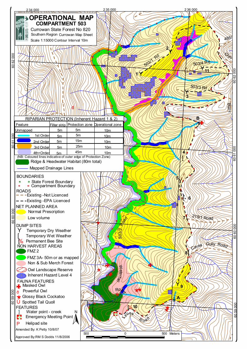
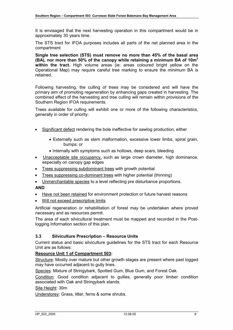
operational map - forestry corporation · amended by: k petty 10/8/07 approved by:rm s dodds...
TRANSCRIPT

Y
[
[
Y
[
Y
%[
Y
Y
[
Y
ÆP
ð
ð
ðð
Ú
Lyons R oad
Caves Gully Road
219/1 Road
Waterfall Road
503 /
2 R
oa
d
Bully B
503/3 Rd
503/4 Rd503/1
Rd Clyde
485/2
B
Aú
ú
1
2
3
4
5
6
7
8
9
10']
11
2 36 0002 35 000
OPERATIONAL MAPCOMPARTMENT 503
Currowan State Forest No 820Southern Region Currowan Map Sheet Scale 1:15000 Contour Interval 10m
60 6
2 00
060
61
000
60 6
2 00
0
Existing -Not LicencedROADS
Existing -EPA Licenced
FEATURES'] Water point - creek
ÆPEmergency Meeting PointHelipad site
NON HARVEST AREAS
Non & Sub Merch ForestFMZ 3A- 50m or as mapped
Temporary Dry WeatherDUMP SITES Y
Low volumeNormal Prescription
NET PLANNED AREA
N
Amended By: K Petty 10/8/07
Approved By:RM S Dodds 11/8/2006
FAUNA FEATURES
Glossy Black CockatooPowerful OwlðMasked Owl
State Forest BoundaryCompartment Boundary
BOUNDARIES
2 34 000
60 6
1 00
0
60 6
0 00
0
60 6
0 00
0
(NB: Coloured lines indicative of outer edge of Protection Zone)
Unmapped
4th+Order3rd Order 2nd Order
1st Order
Feature Filter strip Protection zone Operational zone5m5m
5m5m5m5m
5m15m25m45m
10m
10m10m10m10m
RIPARIAN PROTECTION (Inherent Hazard 1 & 2)
Ridge & Headwater Habitat (80m total)Mapped Drainage Lines
500 0 500 Meters
60 5
9 00
060 5
9 00
0
[%[
Temporary Wet WeatherPermanent Bee Site
Owl Landscape ReserveInherent Hazard Level 4
FMZ 2
Ú Spotted Tail Quoll

Southern Region – Compartment 503 Currowan State Forest Batemans Bay Management Area
HP_503_2005 12-08-05 1
FORESTS NEW SOUTH WALES SOUTHERN REGION HARVESTING PLAN
Batemans Bay Management Area
Currowan State Forest Compartment 503
Contents
Page
OPERATIONAL, FOREST TYPE AND LOCATION MAPS Page............................................................................................................................ 1 1.Safety Considerations ........................................................................................... 2
SITE SPECIFIC HARVESTING PLAN .................................................................................. 6
1a. Area Identification ................................................................................................ 6 2. Description of Proposal.......................................................................................... 6 3. Forest Condition and Silviculture ........................................................................... 7 4. Legal Conditions .................................................................................................. 10 5. Special Requirements.......................................................................................... 10 6. Forest Management Zoning and Approvals ........................................................ 11 7. Cultural Heritage .................................................................................................. 12 8. Flora and Fauna General Conditions .................................................................. 12 9. Flora and Fauna Species-specific Conditions ..................................................... 17 10. Soils and Water ................................................................................................. 18 11. Drainage features .............................................................................................. 18 12. Tree Marking Conditions and Code ................................................................... 20 13. Roading and Crossings ...................................................................................... 21 14. Log Dumps ......................................................................................................... 22 15. Snig Tracks ......................................................................................................... 23 16. Product Specifications and Accounting .............................................................. 24 17. Yield Estimates ................................................................................................... 24 18. Certification ......................................................................................................... 25 19. SFO Acknowledgment ........................................................................................ 25 20. Harvesting Contractor Acknowledgment ............................................................ 25 21. State Forest Employees Acknowledgment ......................................................... 26
SFO Feature Usage Record .............................................................................................. 27
SFO Notes ........................................................................................................................... 31
Record of Threatened Plants or Threatened Fauna Features ....................................... 38
Clearance Certificate ......................................................................................................... 39
Post Logging Information ................................................................................................. 40
APPENDIX 1 POST-HARVEST BURNING PLAN ........................ 42
APPENDIX 2 ROADING PLAN .................................................... 47 Instruction for Existing Road Repair, Maintenance and Construction ....................................... 47
CHECKLIST OF WORKS REQUIRED ON ROADS & CROSSINGS ...................... 48

Southern Region – Compartment 503 Currowan State Forest Batemans Bay Management Area
HP_503_2005 12-08-05 2
1. Safety Considerations
1.1 Hazard identification Assessment of existing hazards was undertaken at the time of planning. These hazards are in the attached table and where appropriate, control strategies have been applied. Where no control strategy has been described, the contractor must develop appropriate strategies as part of the contractors Safety Management Plan. A copy of the hazard assessment and control strategies is provided to assist in the development of the contractors Safety Management Plan for this harvesting area. Identified hazards requiring risk assessment and control strategy in Safety Management Plan
IDENTIFIED HAZARD SUGGESTED CONTROL STRATEGY 1. Adjoining roads of various traffic levels (Kings Highway junction)
Warning signs at intersections, road closure and traffic control measures
2. Hazardous or dead trees Assess area within two tree lengths of work site. Assess risk, & if necessary remove hazard or move work site. Use machinery to assist with hazard removal if possible.
3. Overhead hazards associated with dumps
Assess overhead hazard within two tree lengths of the dump. Assess risk, & if necessary remove hazard or relocate dump site.
Hazard Nos. 1 are shown on the attached Operational Map 1.2 Traffic management/road closures The logging contractor is responsible for traffic control on all roads when felling is within two tree lengths (approx 50 metres) of the road or snigging on roads or loading is occurring within 10 metres of a road. Warning of timber harvesting operations must be displayed 200 metres either side of all road approaches leading to areas where harvesting operations are in progress. Truck warning signs already exist on Lyons road at the junction of the Kings Highway road to warn motorists of logging traffic. Truck entering signs must be placed on the Kings highway, 200 metres either side of the intersection of Lyons road to warn motorists of emerging log trucks.
1.3 Supervision of ‘operator in training’ All new operators entering the work site must be inducted by the reading of the Harvesting Plan and the Site Safety Plan and hold all relevant licences and accreditations. No person is permitted to commence work unless they have been adequately trained and accredited. The training must give instruction in the performance of the work, instruct as to any dangers associated with that work and in any safety precautions which ought to be taken. Field and bush supervisors must ensure that an employer does not permit an untrained employee to operate, without competent supervision, any power driven tool, machine or equipment.

Southern Region – Compartment 503 Currowan State Forest Batemans Bay Management Area
HP_503_2005 12-08-05 3
1.4 Site visitors (1) Authorised
i). All authorised visitors to active timber harvesting/roading operations must wear the following personal protection equipment:
● an approved safety helmet
● suitable heavy duty footwear, with firm ankle support and non-slip soles
● approved high visibility clothing
● eye and ear protection if appropriate
ii). Immediately upon arrival at an active timber harvesting/roading operation, visitors must report to the Supervising Forest Officer (SFO) or bush supervisor who will determine points from which operations can be safely viewed.
iii).The following minimum safety distances must be observed while operations are active:
● Manual tree felling - at least 2 tree lengths (>50metres)
● Log dump operations – 12 metres from the working area (edge of dump perimeter)
● Mechanical harvesting – 2 tree lengths (>50 metres) and when the driver is advised
● Active snig track – at least 2 tree lengths (>50 metres)
● Road & crossing maintenance &/or construction – at least 2 tree lengths (>50 metres).
(2) Unauthorised
i) All unauthorised visitors to active timber harvesting/roading operations must not approach within 100 metres of a person operating timber haulage or harvesting equipment (clause 67(1)(a)) or interfere with such equipment (clause 67(1)(b)) Forestry Regulations 2004. In addition unauthorised visitors must wear the personal protection equipment outlined in 5.4(1)(i) above.
ii) Failure to observe the above guidelines will result in the following procedure:
● All operations to cease immediately
● Unauthorised visitors to be advised that they are in contravention of clause 67(1)(a) or 67(1)(b) of Forestry Regulations 2004 and to leave the site or move outside the 100 metre restricted area immediately.
● Notify the Batemans Bay State Forest Office of unauthorised visitors.
1.5. Emergency Plan Information 1) Mobile phone reception on work site:
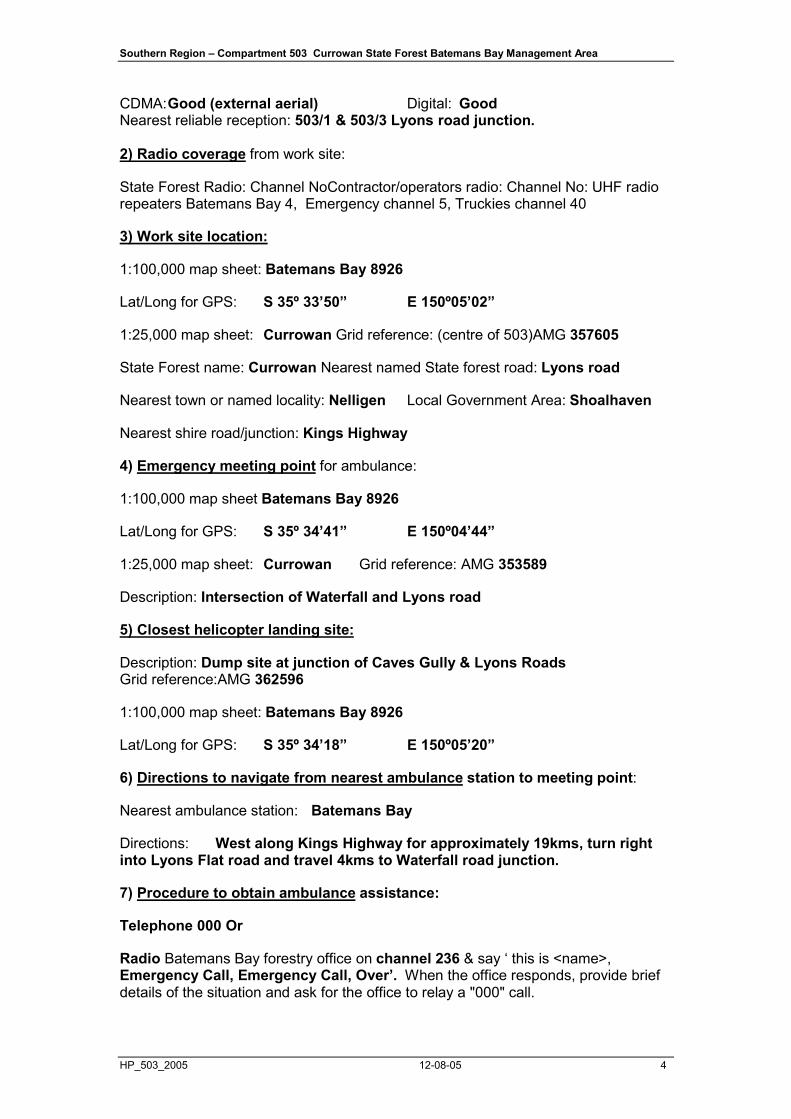
Southern Region – Compartment 503 Currowan State Forest Batemans Bay Management Area
HP_503_2005 12-08-05 4
CDMA: Good (external aerial) Digital: Good Nearest reliable reception: 503/1 & 503/3 Lyons road junction. 2) Radio coverage from work site:
State Forest Radio: Channel NoContractor/operators radio: Channel No: UHF radio repeaters Batemans Bay 4, Emergency channel 5, Truckies channel 40
3) Work site location:
1:100,000 map sheet: Batemans Bay 8926
Lat/Long for GPS: S 35º 33’50” E 150º05’02”
1:25,000 map sheet: Currowan Grid reference: (centre of 503)AMG 357605
State Forest name: Currowan Nearest named State forest road: Lyons road
Nearest town or named locality: Nelligen Local Government Area: Shoalhaven
Nearest shire road/junction: Kings Highway
4) Emergency meeting point for ambulance:
1:100,000 map sheet Batemans Bay 8926
Lat/Long for GPS: S 35º 34’41” E 150º04’44”
1:25,000 map sheet: Currowan Grid reference: AMG 353589
Description: Intersection of Waterfall and Lyons road
5) Closest helicopter landing site:
Description: Dump site at junction of Caves Gully & Lyons Roads Grid reference:AMG 362596
1:100,000 map sheet: Batemans Bay 8926
Lat/Long for GPS: S 35º 34’18” E 150º05’20”
6) Directions to navigate from nearest ambulance station to meeting point:
Nearest ambulance station: Batemans Bay
Directions: West along Kings Highway for approximately 19kms, turn right into Lyons Flat road and travel 4kms to Waterfall road junction.
7) Procedure to obtain ambulance assistance:
Telephone 000 Or
Radio Batemans Bay forestry office on channel 236 & say ‘ this is <name>, Emergency Call, Emergency Call, Over’. When the office responds, provide brief details of the situation and ask for the office to relay a "000" call.
Southern Region – Compartment 503 Currowan State Forest Batemans Bay Management Area
HP_503_2005 12-08-05 5
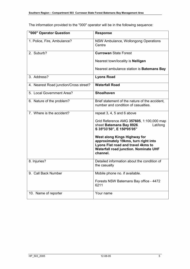
The information provided to the "000" operator will be in the following sequence:
"000" Operator Question Response
1. Police, Fire, Ambulance? NSW Ambulance, Wollongong Operations Centre
2. Suburb? Currowan State Forest
Nearest town/locality is Nelligen
Nearest ambulance station is Batemans Bay
3. Address? Lyons Road
4. Nearest Road junction/Cross street? Waterfall Road
5. Local Government Area? Shoalhaven
6. Nature of the problem? Brief statement of the nature of the accident, number and condition of casualties.
7. Where is the accident? repeat 3, 4, 5 and 6 above
Grid Reference AMG 357605, 1:100,000 map sheet Batemans Bay 8926. Lat/long S 35º33’50”, E 150º05’05”
West along Kings Highway for approximately 19kms, turn right into Lyons Flat road and travel 4kms to Waterfall road junction. Nominate UHF channel.
8. Injuries? Detailed information about the condition of the casualty
9. Call Back Number Mobile phone no. if available.
Forests NSW Batemans Bay office - 4472 6211
10. Name of reporter Your name

Southern Region – Compartment 503 Currowan State Forest Batemans Bay Management Area
HP_503_2005 12-08-05 6
SITE SPECIFIC HARVESTING PLAN
1a. Area Identification
Region Southern Region
Management Area Batemans Bay State Forest Currowan
Compartment 503 Harvest Plan Job Number 2668 Pricing Zone Batemans Bay Foothills Areas
Compartment 503
Event ID 12305 Gross Area (ha) 384
Net Planned Area (ha)
211(55%)
(Refer to Operational Map)
This plan covers the silviculture treatment of the native forest within the net planned area of compartment 503 by the use of commercial harvesting and possibly non commercial tree culling & post harvest burning.
The actual area harvested or treated may be less due to unmapped exclusions, small scale variations in forest condition and commercial viability. Analysis of previously harvested Compartment has estimated the reduction of the Net Planned Area due to unmapped exclusions alone to be in the order of 28% across the Southern Region. 2. Description of Proposal
2.1 Harvesting of native forest Harvesting of native forest, using Single Tree Selection Silviculture subject to the Southern Region IFOA requirements. The primary product of the harvesting is high quality large sawlogs (quota logs), small high quality sawlogs, veneer logs, girders, poles & piles where timber markets are available. Parts of felled logs that do not meet high quality log specifications are segregated and graded into other classifications such as salvage sawlogs, pulp logs & miscellaneous timbers e.g. split & round posts, firewood, mining timbers & craftwood. The availability of miscellaneous timbers depends mainly on forest types, log defectiveness & market conditions at the time of harvesting.
2.2 Clause 22 (IFOA) Consideration All relevant factors have been reviewed taking into account the volume and monetary value of each forest product to supply Term Agreement Holders. The harvesting operation also complies with Clause 22 of the IFOA. Forest management should aim to improve the long-term timber productivity by appropriate harvesting and silvicultural practices whilst addressing all the necessary environmental issues under the Environment Pollution Licence (EPL)

Southern Region – Compartment 503 Currowan State Forest Batemans Bay Management Area
HP_503_2005 12-08-05 7
(when applicable), the Threatened Species Licence (TSL) and the Fisheries Licence (FL).
2.3 Roadworks Maintenance and upgrade to the existing road network. Roading details are contained in Appendix 2.
2.4 Post harvesting burning Post harvesting burning to reduce fuel loads and create suitable seedbeds will be carried out under prescribed conditions. Post-harvest burning details are contained in Appendix 1.
2.5 Silviculture Investment Following harvesting, silvicultural investment may be required on the harvested area to ensure regeneration, thin existing regeneration to desirable spacings or release regeneration from suppression of tree canopy competition.
3. Forest Condition and Silviculture
3.1 Forest History and Condition The compartment has a recorded history of harvesting and silviculture treatment. Three separate logging events have been recorded within compartment 503. The earliest Quota/Salvage sawlog operation occurred in 1965. Pole & mining timber operations occurred in 1969 & 1988.
No evidence of Timber Stand Improvement (TSI) has been recorded or detected.
Records indicate a series of wildfire events in 1938, 1956, 1968 & 1994.
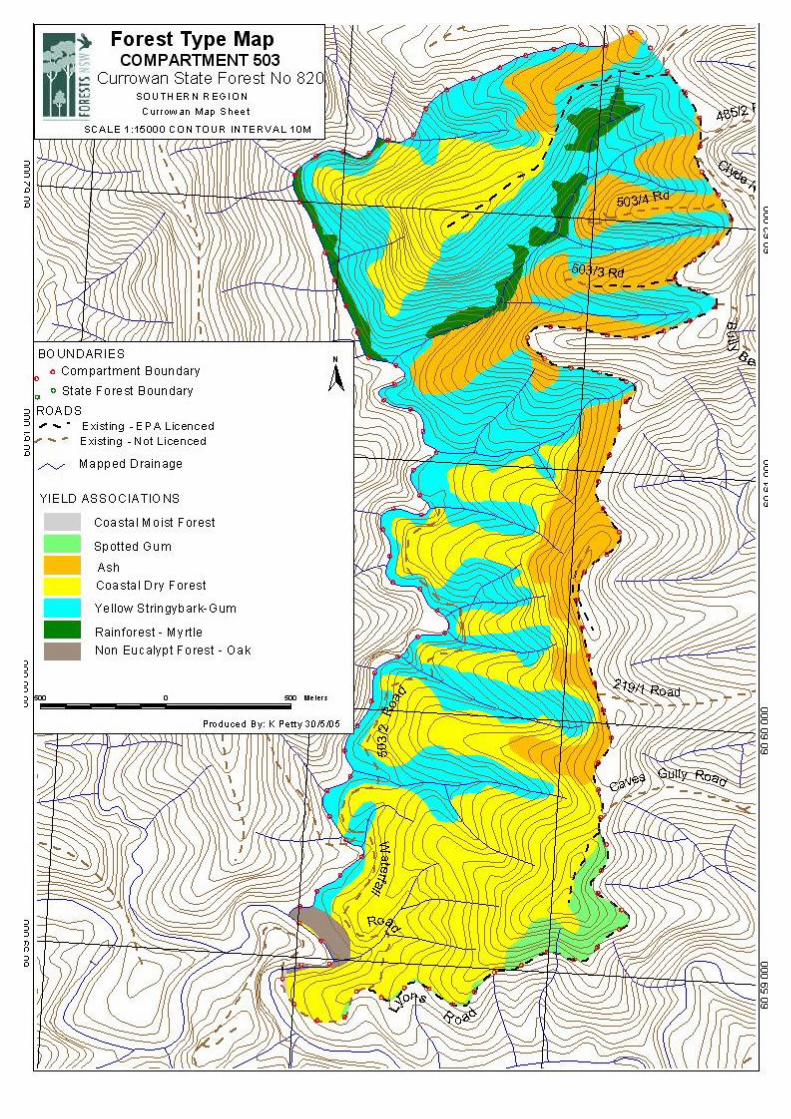
Compartment No. of Samples BA Average (m2/ha) BA Range (m2/ha) 503 27 26 14-32
Yield Association Type Description Gross Area (ha)
1 Coastal Moist Forest 100
2 Spotted Gum 9.5
3 Ash 68
4 Coastal Dry Forest 143
5 Yellow Stingybark-Gum 149
9 Rainforest 12
10 Non Eucalypt 3
3.2 Silviculture Prescription – General The stands are low to medium quality, variable in their structure and include areas of multi-aged regrowth with patches of maturing stands.
Forest stands of mixed age cover 100% of the net planned area (211ha) and will be harvested under a single tree selection (STS) regime with the objective of removing approx 35-45% of mature trees and defective trees containing a sawlog ,while minimising damage to young regenerating stems, and creating canopy openings where appropriate for regeneration.
Southern Region – Compartment 503 Currowan State Forest Batemans Bay Management Area
HP_503_2005 12-08-05 8
It is envisaged that the next harvesting operation in this compartment would be in approximately 30 years time.
The STS tract for IFOA purposes includes all parts of the net planned area in the compartment.
Single tree selection (STS) must remove no more than 45% of the basal area (BA), nor more than 50% of the canopy while retaining a minimum BA of 10m2 within the tract. High volume areas (ie: areas coloured bright yellow on the Operational Map) may require careful tree marking to ensure the minimum BA is retained. Following harvesting, the culling of trees may be considered and will have the primary aim of promoting regeneration by enhancing gaps created in harvesting. The combined effect of the harvesting and tree culling will remain within provisions of the Southern Region IFOA requirements.
Trees available for culling will exhibit one or more of the following characteristics, generally in order of priority:
• Significant defect rendering the bole ineffective for sawlog production, either
• Externally such as stem malformation, excessive lower limbs, spiral grain, bumps; or
• Internally with symptoms such as hollows, deep scars, bleeding • Unacceptable site occupancy, such as large crown diameter, high dominance,
especially on canopy gap edges • Trees suppressing subdominant trees with growth potential • Trees suppressing co-dominant trees with higher potential (thinning) • Unmerchantable species to a level reflecting pre disturbance proportions. AND • Have not been retained for environment protection or future harvest reasons • Will not exceed prescriptive limits
Artificial regeneration or rehabilitation of forest may be undertaken where proved necessary and as resources permit. The area of each silvicultural treatment must be mapped and recorded in the Post-logging Information section of this plan. 3.3 Silviculture Prescription – Resource Units Current status and basic silviculture guidelines for the STS tract for each Resource Unit are as follows: Resource Unit 1 of Compartment 503: Structure: Mostly over mature but other growth stages are present where past logged may have occurred adjacent to gully lines. Species: Mixture of Stringybark, Spotted Gum, Blue Gum, and Forest Oak. Condition: Good condition adjacent to gullies, generally poor timber condition associated with Oak and Stringybark stands. Site Height: 30m Understorey: Grass, litter, ferns & some shrubs.

Southern Region – Compartment 503 Currowan State Forest Batemans Bay Management Area
HP_503_2005 12-08-05 9
Silvicultural Objectives: FMZ 2, exclude from harvesting operation. Practice: Nil Practice: Nil to STS light is envisaged, however due to the very poor nature of the stand, this area is unlikely to be logged. Resource Unit 2, 6 & 7 of Compartment 503: Structure: Unevenaged , 75% of the stand has a diameter of less than 50cm. Dominated by a mature to overmature component. Mostly fully stocked. Species: Stringbark, Spotted Gum, Bloodwood & Silvertop Ash. Condition: Below average. Site Height: 25-30m (site production – poor to average) Understorey: Dry open understorey on upper slopes with a more dense moist shrubby understorey on the lower slopes and heads of gullies. Silvicultural Objectives: Remove defective and commercially sound stems as tree removal limits allow. Attempt to improve stand quality and allow commercially viable stems to grow on. Create gaps to promote regeneration where sufficient disturbance can be achieved. Practice: Aim to use STS light to moderate. However, because of the very low stocking of merchantable stems, the net result is likely to be a mosaic of nil to light BA removal. Resource Unit 5 & 9 of Compartment 503: Structure: Multi-aged with a mature to over mature dominant stand. Generally larger diameter stems compared to surrounding areas. Mature & over mature trees are highly defective. Species: Stringybark, Spotted Gum, Bloodwood and isolated patches of Silvertop Ash. Condition: Poor to fair timber condition depending on species & aspect. Lower slopes carry a better quality stand with more spotted gum and cleaner stems. Timber quality deteriorates with species & grade on the upper slopes. Site Height: 30-35m (site production – average) Understorey: Grass, litter and shrubs on lower slopes. Silvicultural Objectives: Remove all merchantable stems as tree removal limits allow and create gaps to promote regeneration. Practice: Aim to use STS heavy. However, because of the relative lower stocking of merchantable stems, the net result is likely to be a mosaic of light to moderate BA removal. Resource Unit 3, 4 & 10 of Compartment 503: Structure: Mostly over mature but other growth stages are present. Species: Mixture of Stringybark, Silvertop Ash, Bloodwood, and limited Spotted Gum. Condition: Generally poor timber condition. Site Height: 25m Understorey: Grass, litter, some shrubs. Silvicultural Objectives: Exclude from current harvesting operation due to very poor timber quality. Practice: Nil Resource Unit 8 of Compartment 503: Structure: Mostly over mature but other growth stages are present. Species: Predominantly Spotted Gum with some Stringybark..

Southern Region – Compartment 503 Currowan State Forest Batemans Bay Management Area
HP_503_2005 12-08-05 10
Condition: Average. Site Height: 30m Understorey: Grass, litter, some shrubs. Silvicultural Objectives: Remove all merchantable stems as tree removal limits allow and create gaps to promote regeneration and growth of retained future sawlogs. Practice: Aim to use STS heavy. The net result is likely to be a mosaic of moderate to heavy BA removal. 4. Legal Conditions
In 2001, the Commonwealth and NSW Governments signed a Southern Regional Forest Agreement which, among other things, allows for the supply of timber for 20 years from public lands under the following NSW legislation:
• Forestry Act 1916, and • Forestry & National Park Estate Act 1998
The latter Act provides for the Southern Forest Agreement and Southern Integrated Forest Operations Approval (IFOA), both approved by NSW Government Ministers in May 2002. This harvest plan is issued under the authority provided within the IFOA. The IFOA also contains three licences issued under:
• Section 55 of the Protection of the Environment Act 1997 (EPL) • Threatened Species Conservation Act 1995 (TSL). • Section 220ZW of the Fisheries Management Act 1994 (FL). Note: The EPL will not apply unless Forests NSW notifies the IFOA regulator(s)
that it will apply. When the EPL does not apply to this plan, the conditions of the EPL will apply, except felling of trees within the protection zone of unmapped drainage lines will be allowed.
This harvest plan will be managed in the field under:
• Licences issued under the Forestry Act (1916) • Forest Practices Code part 2 (Timber Harvesting in Native Forests - 1999)
and part 4 (Forest Roads and Fire Trails - 1999) Harvesting operations must comply with all of the above Licences (where applicable) and the Code. Further information is available from www.racac.nsw.gov.au and www.rfa.gov.au .
5. Special Requirements
5.1 Non-harvest areas The Operational Map indicates the non-harvest areas (areas not coloured yellow) in the Compartment, as detailed in the legend.
Harvesting disturbance is not permitted in non-harvest areas unless authorised by the Regional Manager.

Southern Region – Compartment 503 Currowan State Forest Batemans Bay Management Area
HP_503_2005 12-08-05 11
5.2 Occupation Permits Apiary 6 apiary sites provided in the table below are located within the planning unit. The contact phone numbers of permittees are available from the Batemans Bay office.
Table 5.2a.
Name Boundary Location
• The SFO must provide the apiary permittees with at least two weeks advance notice when bee boxes need to be removed or relocated.
• Permanent apiary set down sites are located on dump 10 (see Operational Map), must be levelled and free of debris at the completion of logging.
• Permanent sites must not be ripped.
5.3 Rocky Terrain Rocky terrain may be encountered within the net planned area.
Construction of side cut snig tracks should be avoided in areas of rocky terrain.
Where construction of side cut snig tracks in rocky terrain is unavoidable the location of the side cut tracks must be approved by the SFO prior to construction.
6. Forest Management Zoning and Approvals
6.1 Forest Management Zones The Compartment includes the following FMZs:
FMZ 2 – This zone is located along Currowan Creek & Waterfall Road (see Operational Map). Specified harvesting activities must be excluded from these areas, except under certain circumstances, (Refer to section 8.3 of this Plan). FMZ 3A – This zone is located along Lyons Creek (see Operational Map). This zone is comprised of a 50 metre wide exclusion zone either side of the creek bank or as mapped. Specified harvesting activities must be excluded from these areas, except under certain circumstances, (Refer to section 8.3 of this Plan).
FMZ 4 (General Management) – The yellow area is available for harvesting and other silviculture activities. The pink coloured area is excluded from harvesting under this plan (refer to the Operational Map).

Southern Region – Compartment 503 Currowan State Forest Batemans Bay Management Area
HP_503_2005 12-08-05 12
6.2 IFOA Required Approval of Forestry Activities Approvals have been obtained for log haulage along Lyons Road which passes through an area of FMZ 3A. Forestry Operations within the plan area must minimise impacts to the protection zones and meet the requirements of the EPL and General Protection Zones in part 8.3 of this Plan. NOTE: All areas of Rainforest and Protection Zones require prior Regional Manager (&/or Department of Environment & Conservation) approval before forest harvesting related activities (eg: road or snig track construction) can be undertaken. It is the responsibility of the SFO to identify any protection zones which will need to be crossed during harvesting. The SFO should then contact the Planning Forester to obtain the necessary approval. 7. Cultural Heritage
Aboriginal Heritage - Non Aboriginal Heritage - There is no record of Non Aboriginal Cultural Heritage sites within the compartment. Any sites discovered during harvesting must be reported to the Harvesting Forester. Protection of specific sites will be determined on a case by case basis.
8. Flora and Fauna General Conditions
8.1 Pre-harvesting searches During the pre-harvest mark up the SFO must search for and record threatened species habitat features consistent with Conditions 6.2 and 9.6 of the TSL. These include nests, roosts and camps; dens and latrines; scats and scratches; crushed cones; sap feed trees; bat roosts; burrows; soaks and seepage’s; threatened flora and protected native plant species likely to occur within the compartment. Searches for threatened species features must be conducted within that portion of the net planned area where harvesting will occur, and within 50 metres outside this area (eg adjacent compartment, National Park etc) (condition 6.2 of the TSL). Where any of these features are found, the feature must be recorded, the Harvesting Plan (including the Operational Map) must be amended accordingly and the appropriate Condition applied. The results of the database search (recent reliable records within 5km of the compartment) and pre-harvest surveys (threatened flora and fauna traverse, spotlighting, nocturnal callback, riparian frog, non-riparian frog, microchiropteran bats and diurnal bird surveys) resulted in the following consideration of flora & fauna issues: General prescriptions: Glossy Black-Cockatoo (Calyptorhynchus lathami) (Desktop Review, Flora & Fauna Traverse). Species specific prescriptions: Powerful Owl (Ninox strenua) (Desktop Review, Call Playback), Masked Owl (Tyto novaehollandie) (Desktop Review, Spotlight survey), Yellow-bellied Glider (Petaurus australis) (Desktop Review), Spotted-tailed Quoll (Dasyurus maculatus) (Desktop Review).
Site specific prescriptions: Nil
All known flora and fauna information has been considered by the Regional Ecologist in consultation with the Forest Planner in applying general and site specific prescriptions for the protection of the above species. It is acknowledged that 3 of the

Southern Region – Compartment 503 Currowan State Forest Batemans Bay Management Area
HP_503_2005 12-08-05 13
5 species listed above were recorded during pre-harvest surveys and appropriate prescriptions have been applied. All species are adequately protected under their relevant IFOA prescriptions and do not require additional measures.
8.2 Tree Retention
Hollow bearing trees (Non-regrowth zone): See condition 6.6a of the TSL. A minimum of ten hollow-bearing trees must be retained per two hectares of net harvesting area. Where this density is not available, the existing hollow-bearing trees must be retained plus additional trees must be retained to meet the requirement of ten per two hectares. Retained trees must be selected from the trees with the largest diameter and must be live trees with good crown development, minimal butt damage and represent the range of hollowing-bearing species that occur in the area. Recruitment trees: See condition 6.6b of the TSL. A minimum of ten recruitment trees must be retained per two hectares of net harvesting area. Recruitment trees must show potential for developing into hollow-bearing trees, have good crown development, should have minimal butt damage, should not be suppressed, must be mature/late mature where available, and represent the range of species in the area. Stag Retention: See condition 6.6e of the TSL. Where more than ten stags per two hectares occur in the net logging area, a minimum of ten stags must be retained per two hectares of net logging area where it is safe to do so. If there are less then ten stags per two hectares, then all stags should be retained where it is safe to do so. (Marking trees is not a requirement) Significant Food Resources: See condition 6.6f of the TSL. Allocasuarina trees with >30 crushed cones must be retained, damage must be minimised to stands where Allocasuarina species dominate the canopy, sub-canopy or understorey. At least six eucalypt feed trees must be retained in every two hectares of net logging area where they occur (may count H/R/Feed trees). Yellow-bellied Glider (YBG) sap feed trees must be retained and damage to flowering or fruiting banksias and Xanthorrhoea species should be avoided. Protection of retained trees: See condition 6.6g of the TSL. Damage to retained trees must be minimised to the greatest extent practicable. During harvesting operations, the potential for damage to those trees must be minimised by utilising techniques of directional felling. Logging debris must not, to the greatest extent practicable, be allowed to accumulate within 5m of a retained hollow-bearing tree, recruitment tree, stag, Allocasuarina with more than 30 crushed cones beneath, eucalypt feed tree, or YBG sap feed tree. Logging debris within a five metre radius of retained trees must be removed or flattened to a height of less than one metre. Disturbance to ground and understorey must be minimised to the greatest extent practicable within this five metre radius. H and R trees must not be used as bumper trees during harvesting operations. Retained trees must be marked for retention (see condition 6.6g(iii)of the TSL). 8.3 General Protection Zones General exclusions as listed below are shown on the Operational Map. Table 1 Feature/Condition TSL
cond’n Occurs within Planning Unit
High Conservation Value Old Growth 6.3 No Rainforest 6.4 Yes- Depauperate (Dry) Rare Non commercial Forest Types 6.5 No Riparian Protection Zones 6.7 Yes

Southern Region – Compartment 503 Currowan State Forest Batemans Bay Management Area
HP_503_2005 12-08-05 14
Ridge & Headwater Habitat 6.8 Yes Wetlands 6.9 No Heath and Scrub 6.10 No Rocky Outcrops and Cliffs 6.11 No • All rainforest encountered in the field (Warm Temperate, Cool Temperate and
Depauperate (Dry) as described in Research Note 17) is to be excluded from harvest disturbance. Warm Temperate and Cool Temperate rainforest must have an additional 20 metre wide exclusion zone (refer to Table 2 below) .
• The on ground identification and field marking of rainforest and exclusion zones to be established around Warm Temperate and Cool Temperate rainforest must be carried out before or during pre-logging mark-up.
• The location of all rainforest and exclusion zones identified in the field must be shown on a copy of the harvesting plan Operational Map and filed in the compartment history.
• The Operational Map is to be used as a guide to field identification only. It indicates known areas of rainforest together with exclusion zones as might be proven in the field to be required.
Operational Conditions for Protection Zones Operational conditions applying to protection zones are summarised below. Table 2
Protection Feature
Can R
emove accidentally
felled logs if at least one HQ
log (1)
Groundcover
Rehab/R
emoval R
ules
Machinery entry 5m
to fell H
Q log in N
HA
away from
protection zone (2)
2/200 Rule (3)
6/200 Rule (4)
Use existing road/snig Track
tracktrack(4)
IFOA
Licence Conditions
TSL Licence Condition
Heath and Scrub X X X X X X X 6.10
Rainforest (Warm/Cool Temperate) X X X X X 4 4 6.4
Rainforest 20m exclusion zone 4 4 X 4 X 4 4 6.4
Rainforest (Dry) 4 4 X 4 X 4 4 6.4
Bird Nest and Roost sites 4 4 4 X 4 4 X 6.13
Owl Landscape Habitat 4 4 4 X 4 4 4 7.4.2
FMZ 2, 3A 4 X X X X 4 4
Ridge & Headwater Habitat 4 4 4 X 4 4 4 6.8
General Bird Nest and Roost 4 4 4 X 4 4 X 6.13
Rocky Outcrops 4 4 4 X 4 X X 6.11
Cultural Heritage Sites 4 4 X X X 4 X
YBG den 4 4 4 X 4 4 X 7.13
Tiger Quoll 4 4 4 X 4 4 X 7.10
Licence conditions are not breached where a tree is accidentally felled into any Protection zones. 4 - Condition applies X – Condition does not apply. (1) Tree Removal Rules

Southern Region – Compartment 503 Currowan State Forest Batemans Bay Management Area
HP_503_2005 12-08-05 15
An accidentally felled tree may be removed, but only if the tree contains a high quality log. The crown must be cut off from the trunk and left where it has fallen, except where the whole of the tree is lifted out of, or lifted and moved within, the zone using a mechanical harvester; and in removing the tree/log any disturbance to the ground and soil must be minimised. Harvesting machinery that has entered the protection zone for the purpose of felling a tree within the net logging area may also be used to remove a tree that has been felled into the protection zone. However, the wheels or the tracks of the harvesting machinery may not (to any significant extent) be repositioned or moved solely for the purpose of removing the tree felled into the protection zone. (2) Machinery entry (5m) rules Harvesting machinery is permitted to operate in a protection zone for the purposes of felling a tree within the net logging area that contains a high quality log where:
• the technique of directional felling could not be used to fell the tree so that it falls outside the protection zone;
• the only practicable method of felling that is to enter the protection zone and the tree is felled away from the protection zone;
• the wheels or tracks of harvesting machinery remain wholly within 5 metres of the boundary of the protection;
• the use of the harvesting machinery only involves the use of walkover techniques and minimal ground disturbance
(3) 2/200 Rule (Rainforest Only) The felling of trees across the boundary of the Rainforest exclusion zone (20 metres) is prohibited except where the boundary is greater than 200 metres, in which case no more than two (2) trees containing high quality logs are felled across the boundary in any 200 metre length of the boundary of the exclusion zone, whatever 200 metre length of boundary is considered. The exclusion zone is not breached where a tree is accidentally felled into the exclusion zone. An accidentally felled tree may be removed from the zone, but only if the tree contains a high quality log. The trees do not count toward the 2/200 rule. Trees fallen under 2/200 rule must be felled in such a way so as to avoid damage to trees growing in the exclusion zone. No part of the tree felled into the Rainforest can be removed. (4) 6/200 Rule The felling of trees across the boundary of a protection zone is prohibited except where the boundary is greater than 200 metres, in which case no more than six (6) trees containing high quality logs are felled across the boundary in any 200 metre length of the boundary of protection zone, whatever 200 metre length of boundary is considered. The protection zone is not breached where a tree is accidentally felled into a protection zone. An accidentally felled tree may be removed from the zone, but only if the tree contains a high quality log. The trees do not count toward the 6/200 rule. Trees fallen under 6/200 rule must be felled in such a way so as to avoid damage to trees growing in the protection zone. Protection Zones – General Conditions
Southern Region – Compartment 503 Currowan State Forest Batemans Bay Management Area
HP_503_2005 12-08-05 16
A snig track (including a snig track that was in existence before the commencement of this approval) within a threatened species exclusion zone or an exclusion zone in TSL condition 6.8 (“Ridge and Headwater Habitat”) or 8(b) (“General survey requirements”) that has become re-vegetated may be re-opened (by clearing, scraping or treating regrowth), but only if all of the requirements set out in conditions TSL 6.1D (e)-(h) are met. Where a snig track within a threatened species exclusion zone or an exclusion zone referred to in TSL condition 6.8 (“Ridge and Headwater Habitat”) or 8(b) (“General survey requirements”) has become re-vegetated, but none of the trees growing within the zone on the snig track have a DBHOB of 20cm or more, the snig track may be brushed-up, provided TSL conditions 6.1D (i)–(l) are met. A road and snig track may be constructed and used in the above protection zones only with the prior written approval of the Regional Manager, or prior written approval of the Department of Environment and Conservation (DEC), if permitted under the TSL. The SFO must notify the Supervising Forester of the need for any roads/tracks crossing areas. 8.4 General Threatened Flora and Fauna Prescriptions
Feature Records in 503 Licence conditions under the
Threatened Species
Conservation Act
Prescription Summary
Threatened Frog General Protection
Measures
No 6.12 10m exclusion on all dams
Bird Nest and Roost Site Protection
No 6.13 Standard exclusion zones exits around identified nest and roost sites
Tree Bat Roost Protection
No 6.14.1 Likely roost trees must be inspected prior to harvesting operations approaching within 100m of such trees
Subterranean Roost Protection
No 6.14.2 Caves, overhangs, tunnels and mineshafts >3m deep must be inspected prior to harvesting operations approaching within 100m. Exclusion buffers of 10, 50 & 100 meters apply.
Protection of flying-fox Camps
No 6.14.4 Specified forestry activities must be excluded from the full extent of the camp.
Burning Net planned area
6.16 Hazard reduction must reflect the ecological requirements of any threatened species, or their habitat, known or likely to occur in the area.
Ground Habitat Protection
Net planned area
6.17 Protect, to the greatest extent practicable, ground habitat
Southern Region – Compartment 503 Currowan State Forest Batemans Bay Management Area
HP_503_2005 12-08-05 17
Feature Records in 503 Licence conditions under the
Threatened Species
Conservation Act
Prescription Summary
from specified forestry activities
9. Flora and Fauna Species-specific Conditions
Contractors and supervisory staff must immediately report any sightings of Schedule 1 and 2 species to the Supervising Forester. The Harvesting Plan must be amended to include additional prescriptions if necessary.
The following species have been recorded within or nearby the area and the associated prescriptions must be implemented:
Threatened species and habitat features
within trigger distance
Records in 503
Licence conditions under the
Threatened Species
Conservation Act
Prescription Summary
Powerful Owl Ninox strenua Masked Owl Tyto novaehollandie.
Yes
Yes
7.4 Exclusion zones of 50m and 30m respectively for nest and roost sites. Landscape based approach applied.
Spotted tailed Quoll Dasyurus maculatus
Yes 7.10 • search for latrine/den sites • 12ha exclusion around latrine and/or
den sites • 3.5ha exclusion around permanent den
sites Link exclusions to other stream exclusion zones
Yellow-bellied Glider Petaurus australis
No 7.13 • A 50 metre radius exclusion zone must be implemented around dens.
• Within a 100 metres radius of each retained Yellow-bellied Glider sap feed tree, observation or den site record, 15 feed trees of the same species must be retained. Yellow-bellied Glider sap feed trees must not be counted towards these 15 feed trees. Retained feed trees must have good crown development and should have minimal butt damage and should not be suppressed. Mature and late mature trees must be retained as feed trees where these are available. Retained trees must be marked for
Southern Region – Compartment 503 Currowan State Forest Batemans Bay Management Area
HP_503_2005 12-08-05 18
Threatened species and habitat features
within trigger distance
Records in 503
Licence conditions under the
Threatened Species
Conservation Act
Prescription Summary
retention.
10. Soils and Water
Feature Compartment 503 Inherent hazard level 2 Dispersible Soils No Mass Movement No Seasonality restrictions No 10.1 Slope limits (Inherent Hazard Level 4)
Maximum slope for harvesting Maximum grade for snig track construction
30 degrees(i) 25 degrees(ii)
(i) Harvesting on slopes over 30° (unmapped inherent hazard level 4) may occur consistent with Condition 3, Schedule 4A of the Environment Protection Licence.
(ii) The grade of snig tracks may only exceed 25 degrees to:
• negotiate poorly drained land, rock outcrops or unstable soils;or • to take advantage of favourable terrain, such as to reach a geologically
stable bench or saddle; or • to take advantage of soil which is more suitable for snig track
construction and drainage. (NB: Such instances must be documented in the SFO Notes section of this plan, Condition 41 of Schedule 4A of the EPL)
11. Drainage features
11.1 Prescribed streams Currowan Creek is a prescribed stream.
11.2 Drainage feature protection Filter strips (EPL), Protection Zones (EPL), Operational Zones (EPL), Protection Zones -hard (TSL) and Protection Zones -soft (TSL) must be retained along all drainage lines, prescribed streams and watercourses within the net planned area of the Compartment at minimum widths as stated in the Table below. Table 1: Minimum filter strip, protection zone and operational zone widths for mapped and unmapped drainage lines, prescribed streams and watercourses in native forests in Inherent Hazard Level 1 & 2 (metres – measured along the ground surface)
Southern Region – Compartment 503 Currowan State Forest Batemans Bay Management Area
HP_503_2005 12-08-05 19
Stream Order EPL Filter Strip TSL Protection
(hard)
EPL Protection Zone
TSL Protection* (soft)
EPL Operational
Zone
Unmapped 5 5# 10 1st order 5 5* 10 2nd order 5 15* 10 3rd order 5 25* 10 4th order or greater 5 45* 10
NOTE: # In the event that Forests NSW chooses to harvest this area without EPL coverage, all EPL conditions continue to apply except for the rule applying to the cutting of trees from within the protection zone of the unmapped drainage lines. In this case, trees within protection zones of unmapped drainage lines may be felled and removed.
Protection Feature
Can R
emove accidentally
felled logs if at least one HQ
log
Groundcover
Rehab/R
emoval R
ules
Machinery entry 5m
to fell H
Q log in N
HA
away from
protection zone
Trees can be felled into zone if at least one H
Q log
Use existing road/snig track
IFOA
Licence Conditions
(Schedule 6 Road/snig track
construction)
EPL Condition
TSL Licence Condition
Filter Strip (EPL) 4 4 X X 4 4 17-20 X
Protection zone (hard) TSL 4 4 X X 4 4 X 6.7
Protection zone (soft) EPL & TSL N/A 4 4 4 4 4 20A-20J 6.7
Operational zone (EPL) N/A 4 N/A 4 4 X 20K-20U X
Licence conditions are not breached where a tree is accidentally felled into any Protection zones. 4 - Condition applies. X – Condition does not apply. N/A – Not applicable. General conditions • the width of a Filter Strip & Protection zone (hard) is be measured from the top of
the bank of the incised channel, or, where there is no defined bank, from the edge of the channel.
• the width of a protection zone (soft) is to be measured from its boundary with the adjoining filter strip or protection zone (hard).
• the width is to be measured along the ground surface. • 5m wide buffer strips must be retained along all drainage depressions.
Conditions 15, 16, 21-23 of Schedule 4A of the EPL must apply (Buffer strips). FL conditions • There is no class 1 or 2 Aquatic Habitat with the compartment.

Southern Region – Compartment 503 Currowan State Forest Batemans Bay Management Area
HP_503_2005 12-08-05 20
12. Tree Marking Conditions and Code
• Marking-up must be conducted at least 100 metres in advance of harvesting operations, and either side of road construction and road re-opening operations so that relevant exclusion and protection zones can be implemented prior to harvesting, road construction and road re-opening.
• All hard exclusion zones boundaries must be marked in the field, except where specified forestry activities will not come within 50 metres of such boundaries. Retained trees referred to in section 8.2 of this plan must be marked. The only exception to the marking of the retained trees is where the understorey consists of thick impenetrable lantana greater than one metre high or other impenetrable understorey. The SFO must document and justify such situations as it becomes apparent during compartment mark-up.
HARVEST MARKING CODE Description Symbol
A. STANDARD MARKINGS/SYMBOLS MARKINGS/SYMBOLS THAT DELIVER KEY REQUIREMENTS ON A STATEWIDE BASIS Compartment boundary Where not defined by clear features eg. Road, creek
Double band of Pink tape
Hard exclusion zone/Filter strip Trees must not be felled into these areas, except where a tree is felled accidentally.
One band of Yellow & Pink
tape Warning sign (eg hangup, mine etc)
Ø
Edge of net planned area (eg unmerchantable) Retained trees and critical boundaries to be marked within 30m beyond the boundary Tree heads may fall across the line, provided they comply with boundary and tree retention rules (eg 5m debris)
“¤”
Soft Exclusion Zone / Protection Zone Areas where disturbance by harvesting is allowed only under specified conditions
One band of Pink tape PLUS
width of Zone in paint Extraction System Road/Track line
“I” or tape
Dump site with optional dump number reference
“D” or red tape
Approved crossing site “b” Slope angle indication (commences here) eg “25o” Trees To Be Removed Individual tree
“•” or dots
Directional felling mark “ç” over “•” Retained Trees Retained trees not to be removed or damaged (eg grower, Yellow-bellied Glider potential feed tree)
One horizontal line or ring
PLUS Habitat tree, for any flora or fauna. “H”

Southern Region – Compartment 503 Currowan State Forest Batemans Bay Management Area
HP_503_2005 12-08-05 21
Description Symbol Eucalypt feed tree (Flowering eucalypt) “E” Edge of identified AGS ‘groups’ “*” Recruitment tree “R”
Cancellation Mark Mark to formally cancel previous marks
“X”
B. SPECIALIST MARKINGS/SYMBOLS Additional specialist Markings/Symbols that may be used in place of, or additional to standard markings to highlight particular issues as required by regulators, Forests NSW, or others. Flora Fauna Features Retained Tree Glossy black cockatoo feed tree, record or nest
One horizontal line or ring PLUS
“GB”
Owl nest and/or roost “OWL” Nest (raptors, parrots etc.) “N” Yellow-bellied Glider v-notch feed tree or record “Y” Squirrel Glider sap feed tree, record or nest “SG” Koala high use tree “K” Koala retained feed tree One horizontal line or ring Frog record “F” Smoky Mouse record “SM” Quoll record; latrine; den “Q”; “QL”; “QD” Bat record; roost “B”; “BR” Phascogale den “PD” Philoria frog seeps and soaks “FPH” Threatened plant “TP” Other Markings Possible Pole/Girder “•” with “P” or“G” Private property “PP” Cave, tunnel or mineshaft “CTM” Drainage Depression Centre line “DD” Cultural Heritage site “CH”
13. Roading and Crossings 13.1 Location The Operational map indicates the location of existing roads and crossings on State Forest. Feature Length &/or Number Work Required Existing Roads 8135 metres Yes New Roads Nil N/A Existing Crossings 2 Yes New Crossing Nil N/A Borrow & Gravel Pits Nil N/A Roading and crossing details are contained within Appendix 2 of this Plan. The roading and crossing works must be undertaken, by contractor or Forests NSW staff, prior to the commencement of harvesting activity in the area served by the road or crossing. Forests NSW will supervise and pay for the maintenance

Southern Region – Compartment 503 Currowan State Forest Batemans Bay Management Area
HP_503_2005 12-08-05 22
works. State Forest roads that are not EPA Licenced (refer to Operational Map) are not to be used by log trucks. They may be used with SFO approval for snigging or extraction provided they are drained to appropriate specifications. • Road drainage must be constructed at the time of road opening and must be
maintained during the operation. All crossbanks or spoon drains on roads in the compartment must be constructed to allow safe movement of loaded log trucks and ensure effective road drainage is maintained.
• The SFO must ensure that the road pavement is maintained to a standard sufficient to avoid disruption to truck haulage. Patch gravelling may be required and should be arranged through the Supervising Forester.
• The SFO must ensure any changes to site specific prescriptions as detailed in the roading plan are well documented within the roading appendix.
13.2 Wet Weather Controls Haulage is not permitted on natural surface roads when there is runoff from the road surface. Loaded trucks and partially loaded trucks may complete their journey.
14. Log Dumps
14.1 Location 10 log dumps are indicated on the Operational Map. Field location of log dumps must utilise the most level site available consistent with the location indicated on the Operational Map. The area covered by a log dump must be as small as practicable. A maximum of three log dumps may be in operation at any one time, however an additional two log dumps may be used subject to the Supervising Forester’s approval.
The SFO may approve additional or relocate log dumps if required. In the case of relocation or additions a minor amendment form should be completed by the SFO. If any road construction or extension of existing road is required the Supervising Forester must be informed and appropriate amendments prepared.
14.2 Treatment Inherent hazard level 2 Conditions 26, 27, 28, 30, 31 and 33 of Schedule 4A of the EPL must apply.
• Runoff from log dumps must not be discharged into drainage features.
• Log dumps must be located outside filter strips, protection zones and buffer strips.
• Debris from log dumps must be located outside filter strips, protection zones and buffer strips.
• Dumps must be located at least 10 metres from the outer boundary of protection zones, unless the construction of the log dump at least 10 metres from the outer boundary of the protection zone would result in additional excavation compared to a log dump located closer to the protection zone.
• Debris from log dumps must be located at least 5 metres from the outer boundary of protection zones.

Southern Region – Compartment 503 Currowan State Forest Batemans Bay Management Area
HP_503_2005 12-08-05 23
14.3 Expected Felling/ Extraction & Loading Method The expected felling method is manual/mechanical, extraction method by skidder/dozer, and loading method is by excavator. 15. Snig Tracks
15.1 Technique It is preferable that, wherever practicable, walkover extraction techniques be used in preference to snig track construction. Conditions 38-41 of Schedule 4A of the EPL must apply (Snig tracks). The SFO must approve in writing the use of snigging/extraction equipment on roads and all roads must be returned to their pre-harvesting condition by the logging contractor immediately after a road has ceased being used for harvesting. 15.2 Drainage of Snig Tracks Where walkover techniques cannot be used and/or significant lengths of extraction tracks are exposed, snig tracks must be drained according to the maximum spacings in the table below:
Track Grade (degrees)
Maximum Distance (metres)
0 - <5 100 >5 - <10 60
>10 - <15 40 >15 - <20 25 >20 - <25 20
>25 15 The table may be interpolated to derive site-specific maximum spacings.
• Conditions 70-80 of Schedule 4A of the EPL must apply (Drainage of Snig Tracks) 15.3 Crossbank Height The minimum unconsolidated crossbank height must be 35 cm, and the minimum consolidated crossbank height must be 25 cm. The EPA recommends a maximum unconsolidated height of 50cm. 15.4 Drainage Feature Crossings Where a snig track (existing) within a protection zone has become re-vegetated, but none of the trees growing on the snig track within the zone have a DBHOB of 20cm or more, the snig track may be brushed-up provided condition 6.7.3(e) of the TSL is met. All new snig track crossings must be authorised by the Regional Manager. Condition 6.7 of the TSL and Conditions 42-69 of Schedule 4A of the EPL must apply (Snig tracks - crossings). 15.5 Downhill Snigging Limited downhill snigging or extraction is required. • Where downhill snig or extraction tracks connect directly with a log dump, either
the snig tracks must enter the log dump from the side or below, or a drainage structure must be in place immediately before a snig track enters the log dump at the end of each day’s operation. Condition 82 of Schedule 4A of the EPL must apply (Downhill snigging).
Southern Region – Compartment 503 Currowan State Forest Batemans Bay Management Area
HP_503_2005 12-08-05 24
15.6 Wet Weather All snigging and extraction must cease when water is running in tracks or tracks are likely to be significantly rutted. Prescription 81 of Schedule 4A of the EPL must apply (Wet weather-snig tracks). 15.7 Mass Movement Compartment 503 is not in an area identified as having a potential for mass movement. No specific prescriptions relating to mass movement/snigging are required.
15.8 Suitability of existing log dams and gully stuffers There are no known log dams or gully stuffers on snig track crossings in the Compartment. The suitability of any existing log dam or gully stuffers must be determined by a suitably qualified person, the determination enclosed in the compartment/stand history file and any recommendations for use prescribed in the harvest instructions before the log dam or gully stuffer is used for extraction. Condition 47 of Schedule 4A of the EPL must apply. 16. Product Specifications and Accounting
All timber products obtained from the planning unit must be graded and accounted for prior to their departure from the loading point in a format agreed to by Forests NSW.
Sawlogs must be serviced and graded in accordance with the Hardwood Log Measurement Manual Southern Region (Jan 2002).
Sawlog sales must comply with the Code of Procedure for Sale of Hardwood Sawlogs by Gross Volume Measurement from Crown Timber Lands within Forests NSW Southern Region (Edition July 1999).
Pulpwood sales must comply with the Code of Procedure for the Sale of Hardwood Pulpwood by Weight Using Truck Delivery Dockets as Basis for Account, between South East Fibre Exports Pty Ltd and Forests NSW.
17. Yield Estimates
Native forest 503 Est yield/ha Est total volume Quota logs (HQL) 2.5 m³/ha 500m³ High Quality Small 0.25m3/ha 50m3 Salvage logs 3.5m³/ha 700m³ Pulp logs 3t/ha (2.5 m3/ha) 600 t (500m3) TOTAL 8.75m³/ha 1750m 3
Yield estimates are based on field sampling and ocular estimates and harvest data from neighbouring Compartment. Yields per hectare estimates are an average over the net planned area are will vary depending on the actual area harvested.

Southern Region – Compartment 503 Currowan State Forest Batemans Bay Management Area
HP_503_2005 12-08-05 25
18. Certification
Prepared by: Kevin Petty
Signature: Date:
Harvest Planning Team Leader
Endorsed by: Ian Barnes
Signature: Date:
Position PLANNING MANAGER
Approved by: Steve Dodds
Signature: Date:
Position A/REGIONAL MANAGER
19. SFO Acknowledgment
I acknowledge that I have received a copy of the Harvesting Plan for Compartment 503 in Currowan State Forest and that I have been briefed on the conditions of the Plan and understand the supervision and operational control requirements as explained to me by the Harvesting Forester or his/her delegate.
Signature Date:
Position SUPERVISING FOREST OFFICER
Signature Date:
Position RELIEVING SUPERVISING FOREST OFFICER
20. Harvesting Contractor Acknowledgment
I acknowledge that I have received a copy of the Harvesting Plan for Compartment 503 in Currowan State Forest and that I understand the conditions of the Plan as explained to me and the operators present by a Forests NSW Officer.
Name:
Date/signature: / /
Position: Principle Contractor/Crew Leader/Operator
Name Position/Role Initial/Signature

Southern Region – Compartment 503 Currowan State Forest Batemans Bay Management Area
HP_503_2005 12-08-05 26
21. State Forest Employees Acknowledgment
I acknowledge that I have been briefed on the contents of the Harvesting Plan for Compartment 503 in Currowan State Forest and that I understand the conditions of the Plan as explained to me by a Forests NSW Officer.
Name Date Position/Role Signature

Southern Region – Compartment 503 Currowan State Forest Batemans Bay Management Area
HP_503_2005 12-08-05 27
SFO Feature Usage Record
Dates of commencement and cessation of logging Date of commencement of logging: _____________
Date of cessation of logging: __________________
DUMP USAGE RECORD • Record the commencement and completion of harvesting at each dump • Record the occurrence of temporary stopping of harvesting at each dump.
Dump
number Start date
Finish date
*Track drainage
completed within 2 days
(yes/no)
Date of temporary cessation
**Temporary track drainage completed
within 5 days (yes/no)
Date resumed
*At completion of snig track/dump, track drainage must be completed within 2 days unless soil is saturated.
*At temporary cessation of snig track use, track drainage must be completed within 5 days unless soil is saturated.
Situations where drainage could not be completed due to saturated soils must be recorded in SFO Notes.

Southern Region – Compartment 503 Currowan State Forest Batemans Bay Management Area
HP_503_2005 12-08-05 28
Construction, upgrading or maintenance of drainage feature crossings by snig tracks or extraction tracks
• Record the commencement and completion of each construction, upgrading or maintenance of drainage feature crossings by snig tracks or extraction tracks.
Type of
operation * Location of
crossing Date
commenced Soil stabilisation completed within 5 days (yes/no)
Date completed
* If clearing exceeds 3 metres, and was not authorised in the original harvest or road instructions, please provide reason for field approval in each incidence:
1 _________________________________________________________________
2 _________________________________________________________________
3 _________________________________________________________________
4 _________________________________________________________________

Southern Region – Compartment 503 Currowan State Forest Batemans Bay Management Area
HP_503_2005 12-08-05 29
Bi-weekly checks of road drainage structures during haulage operations.
• Record the date of checks, drainage structure compliance and the any repairs required within the specified time period.
Road name * Date road checked
Compliance Y/N
Repair completed
within 2 days Y/N or N/A
Repair completed
within 5 days Y/N or N/A
Forests NSW must repair the road and road drainage structures:
a) within 2 days where the repair work does not require the use of machinery; or
b) within 7 days where the repair work requires the use of machinery.
* Roads include road drainage crossings and also implies crossing approach drainage.

Southern Region – Compartment 503 Currowan State Forest Batemans Bay Management Area
HP_503_2005 12-08-05 30
Bi-weekly checks of road drainage structures during haulage operations.
• Record the date of checks, drainage structure compliance and the any repairs required within the specified time period.
Road name * Date road checked
Compliance Y/N
Repair completed
within 2 days Y/N or N/A
Repair completed
within 5 days Y/N or N/A
Forests NSW must repair the road and road drainage structures:
a) within 2 days where the repair work does not require the use of machinery; or
b) within 7 days where the repair work requires the use of machinery.
* Roads include road crossings and crossing approach drainage.

Southern Region – Compartment 503 Currowan State Forest Batemans Bay Management Area
HP_503_2005 12-08-05 31
SFO Notes
Date Event Signed

Southern Region – Compartment 503 Currowan State Forest Batemans Bay Management Area
HP_503_2005 12-08-05 32
SFO Notes (continued) Date Event Signed

Southern Region – Compartment 503 Currowan State Forest Batemans Bay Management Area
HP_503_2005 12-08-05 33
SFO Notes (continued) Date Event Signed

Southern Region – Compartment 503 Currowan State Forest Batemans Bay Management Area
HP_503_2005 12-08-05 34
SFO Notes (continued) Date Event Signed

Southern Region – Compartment 503 Currowan State Forest Batemans Bay Management Area
HP_503_2005 12-08-05 35
SFO Notes (continued) Date Event Signed

Southern Region – Compartment 503 Currowan State Forest Batemans Bay Management Area
HP_503_2005 12-08-05 36
NOTICE OF MINOR VARIATION TO HARVEST PLAN STATE FOREST:……………………………. COMPARTMENT:…………………………. SFO Name: …………………………………… Contractor Name: ………………………….. No:____ Condition to be varied
______________________________________________________________________________________________________________________________________________________________
Physical area within the compartment in relation to which the variation will occur.
___________________________________________________________________________________________________________________________________________________________________________________________________________________________________________________________________________________________________________________________________________________________________________________________________________
SFO Signature:………………………………….. Date:………………………… Contractor Signature:…………………………… Date:…………………………. Forest Planner Notified: ……………………… Date : ……………………….. __________________________________________________________________________________ No: ____ Condition to be varied
______________________________________________________________________________________________________________________________________________________________
Physical area within the compartment in relation to which the variation will occur.
___________________________________________________________________________________________________________________________________________________________________________________________________________________________________________________________________________________________________________________________________________________________________________________________________________
SFO Signature:………………………………….. Date:………………………… Contractor Signature:…………………………… Date:………………………… Forest Planner Notified: ……………………… Date : ……………………….. ___________________________________________________________________________________ No:____ Condition to be varied
______________________________________________________________________________________________________________________________________________________________
Physical area within the compartment in relation to which the variation will occur.
___________________________________________________________________________________________________________________________________________________________________________________________________________________________________________________________________________________________________________________________________________________________________________________________________________
SFO Signature:………………………………….. Date:………………………… Contractor Signature:…………………………… Date:………………………… Forest Planner Notified: ……………………… Date : ………………………..

Southern Region – Compartment 503 Currowan State Forest Batemans Bay Management Area
HP_503_2005 12-08-05 37
NOTICE OF MINOR VARIATION TO HARVEST PLAN STATE FOREST:……………………………. COMPARTMENT:…………………………. SFO Name: …………………………………… Contractor Name: ………………………….. No:____ Condition to be varied
______________________________________________________________________________________________________________________________________________________________
Physical area within the compartment in relation to which the variation will occur.
___________________________________________________________________________________________________________________________________________________________________________________________________________________________________________________________________________________________________________________________________________________________________________________________________________
SFO Signature:………………………………….. Date:………………………… Contractor Signature:…………………………… Date:…………………………. Forest Planner Notified: ……………………… Date : ……………………….. __________________________________________________________________________________ No: ____ Condition to be varied
______________________________________________________________________________________________________________________________________________________________
Physical area within the compartment in relation to which the variation will occur.
___________________________________________________________________________________________________________________________________________________________________________________________________________________________________________________________________________________________________________________________________________________________________________________________________________
SFO Signature:………………………………….. Date:………………………… Contractor Signature:…………………………… Date:………………………… Forest Planner Notified: ……………………… Date : ……………………….. ___________________________________________________________________________________ No:____ Condition to be varied
______________________________________________________________________________________________________________________________________________________________
Physical area within the compartment in relation to which the variation will occur.
___________________________________________________________________________________________________________________________________________________________________________________________________________________________________________________________________________________________________________________________________________________________________________________________________________
SFO Signature:………………………………….. Date:………………………… Contractor Signature:…………………………… Date:………………………… Forest Planner Notified: ……………………… Date : ………………………..

Southern Region – Compartment 503 Currowan State Forest Batemans Bay Management Area
HP_503_2005 12-08-05 38
Record of Threatened Plants or Threatened Fauna Features Features
As a requirement of the TSL SFOs must - in the course of conducting other activities before, during and after operations - look for and record in this table the location and protection of detected threatened plants or animals or threatened fauna features. Note that some features or species (eg. a single Glossy Black-Cockatoo feed tree) require no further prescription but should still be recorded; other features or species (eg. caves/mineshafts) will require an immediate prescription and/or further survey before further logging can take place within the vicinity.
DATE
SPECIES/ FEATURE
OBSERVER
RECORD TYPE *
COUNT
AMGS/NOTES
Eg 30/11/04 Raptors nest K. Rowley O 1 E 234270 N 5992130 – in Spotted Gum
*Codes for Record Types
O Observed K Dead W Heard Call F Tracks, scratching S Shot Z In raptor/owl pellet H Hair, feathers, or skin X In Scat E Nest/roost R Road kill B Burnt M Miscellaneous D Dog Kill T Trapped Netted N Not located C Cat kill Y Bone or teeth A Stranding/beached V Fox Kill P Scat
Eucalypt species flowering during period of harvesting operation: Month:……………Species:…………………………….……………………………………… Month:……………Species:……………………………….…………………………………… Month:……………Species:……………………………….…………………………………… Month:……………Species:……………………………….…………………………………… Notes on Checklist Some of the flora or fauna features in particular compartment may occur in quite large numbers (eg GBC feed trees) - in this case estimates will suffice. Locations of features should be noted on map. For each occurrence/population an incidental fauna/flora record form must be filled out and provided to the Region Ecologist. Notes on winter flowering eucalypts that may assist implementation of significant food resources prescription.
Southern Region – Compartment 503 Currowan State Forest Batemans Bay Management Area
HP_503_2005 12-08-05 39
Clearance Certificate
COMPARTMENT: 503 Currowan STATE FOREST Southern REGION To ..............................................................................................Supervising Forest Officer I request approval for me to move my logging crew and all associated machinery from the above-mentioned area to the next compartment in accordance with Section 3.5 of the Forest Practices Code. I certify that: (a) all permanent roads, trails and mitre drains have been cleared of harvesting debris; (b) butt damage to retained trees has been kept to acceptable limits; (c) all trees marked for removal have been felled; (d) utilisation limits have been satisfactorily met; (e) stump heights conform to requirements; (f) all hanging trees have been felled and brought down; (g) all log dumpsites have been satisfactorily restored as required; (h) harvesting debris is not accumulated around retained trees; (I) all accumulated litter has been disposed of properly; (j) all filter and buffer strip requirements have been complied with; (k) all snig track, extraction track and temporary logging road drainage has been
installed satisfactorily and other required rehabilitation work has been completed; (l) all necessary repairs to damaged roads, signs, fences and other structures have
been carried out. (m) _______ (insert quantity) rubber flaps have been recovered in a satisfactory
condition and reported to Operations Branch for collection. I believe that I have met all my obligations under the conditions of the Timber Licence, the EPL and TSL which apply to the compartment just completed, as stated in this Harvesting Plan. Signature...................................................Name......………..................Date .................. Contractor As a result of inspections of the logging operations made in accordance with this Harvesting Plan, I am satisfied that, to the best of my knowledge, the contractor responsible for this harvesting operation has satisfactorily completed all work and approval is given for her/him to remove her/his machinery and equipment and leave the area/commence operations in another compartment. This clearance does not release the contractor from any obligation to undertake any remedial work if subsequent deficiencies are shown to result from inadequate practices during the harvesting operation, which are found during any inspections of the area made within 12 months of the date of this post-harvesting inspection. Last inspection was made on ...........................................................(Date) Signed .........................................................................(Date).................... Supervising Forest Officer

Southern Region – Compartment 503 Currowan State Forest Batemans Bay Management Area
HP_503_2005 12-08-05 40
Post Logging Information
Record any circumstances of significance relating to the harvesting of this compartment. Please draw or include any annotations on the attached operation scale map. Summary of silvicultural treatment
Treatment type Area (ha) subject to treatment
(SFO estimate)
Number of AGS gaps created
Comments
Australian Group Selection Single Tree Selection Thinning/Spacing Post Harvest Silviculture Actual area harvested (record on attached Operational Map)
Give reasons for harvestable areas that were not harvested (eg. Too steep, defective timber). Make reference to map.
Post Logging Basal Area sweeps
Dump No# Sample 1 Sample 2 Sample 3 Sample 4 Average Post BA Average m2/ha Pre BA Average 26m2/ha
Comply with maximum STS BA removal of 45% or Thining BA removal of 60% Y/N

Southern Region – Compartment 503 Currowan State Forest Batemans Bay Management Area
HP_503_2005 12-08-05 41
Possible next cut (tick appropriate boxes)
Main product type Anticipated volume Time to next harvest H M L 0 to 5 years Girders 5 to 10 years Veneer 10 to 20 years Poles/piles 20 to 30 years Quota 30 plus years Smalls/Thinnings Salvage Pulpwood/chipwood Noxious or environmental weed problems; high levels of feral animal use. _________________________________________________________________________ _________________________________________________________________________ Sites of soil erosion for attention. _________________________________________________________________________ _________________________________________________________________________ Boundary compromised; neighbour issues resulting from logging or haulage. _________________________________________________________________________ _________________________________________________________________________ Operation map errors for Planning Forester attention (eg forest type; roads). _________________________________________________________________________ _________________________________________________________________________ Any other comments – SFO / FA / Forester _________________________________________________________________________
_________________________________________________________________________
Attach SCION printout
Southern Region – Compartment 503 Currowan State Forest Batemans Bay Management Area
HP_503_2005 12-08-05 42
APPENDIX 1 POST-HARVEST BURNING PLAN
Planning Information
LGA: Shoalhaven Shire
Fuel Management Zone & Proposed Burn Summary
(Refer to Section 1 & 2 of the Harvest Plan for details)
Fuel Load (t/ha): 50-150 tons per hectare of Logging Slash - est 10 t/ha between fallen tree
heads.
Season: autumn / winter / spring Zone 3B Post-Harvest
Fuel Reduction Objectives: % of net planned area to be burned: approx 75% Reduce fuels to: < 5 t/ha
Regional Burning Guideline
Max Temp (°C): 20°C Min RH (%): 40% Max BKDI: 100
Max Wind Speed (km/h): 15 km/h Max FDI: 6 (Calculate using McArthur Meter if favourable conditions deteriorate) Minimum Fuel Moisture Content: 12% (16% on edge of Main Drainage lines, not in dry up-
slope filter strips)
Max Rate of Spread: 1.5 m/min (Regulate with lighting pattern. Eg, A single “spot fire” on
the up-hill side of head, and don’t light heads directly beneath deliberately retained trees) Average Flame height: 5m (Post-logging burn tree head debris only)
Scorch Height: to 15m (ie, scorch height = approx 3 times flame height)
Environmental Prescriptions
Flora, Fauna & Other Exclusions
(Refer to Sections 6, 7, 8, 9 & 10 of the Harvest Plan for details) Soil, Water & Aquatic Habitat
Preferred months of burn: April to September (Post-Logging)
Filter Strip Protection: Fire to be excluded from main gully filter strips using fuel moisture differentials. (Refer to Section 11 & 12 of Harvest Plan for details)
Soil exposure: Mineral earth exposure limited to less than 15% of undisturbed area (post harvest burn only)
Aquatic habitat protection - Fire to be excluded from main gully filter strips using fuel moisture differentials. (Refer to Section 12 of Harvest Plan for details)

Southern Region – Compartment 503 Currowan State Forest Batemans Bay Management Area
HP_503_2005 12-08-05 43
Notification and Resource Requirements
Neighbours: Refer to Section 6 of the Harvest Plan - Special Requirements for names and contact details. Refer to Operational Map for neighbour locations.
Neighbours have been notified by letter at the time of Harvest Planning. 24 hour notice given to Neighbours: YES NO Permittees/Apiarists: Refer to Section 6 of the Harvest Plan - Special Requirements for names and contact details.
Permitees have been notified by letter at the time of Harvest Planning.
24 hour notice given to Permittees: YES NO
Contractors: YES NO Shire FCO: YES NO Govt Agencies: YES NO Lessees: YES NO Smoke / Hazard Reduction Signs required: YES NO (circle action)
Neighbours Burning in Conjunction: …………………………………………………………………………………. Resources required: Personnel: All available Tankers: On standby (at Depot) Slip-ons: A minimum of 1. Dozers: N/a Aircraft: N/a No. of capsules: N/a Other agency resources: N/a
Note: It is the responsibility of the Burn OIC to ensure all relevant notifications have been made. Comments: Burn Site Map: (Refer to Operational Map for details).
Risk Assessment and Safety Measures
Risk assessment and safety requirements
1. Burn injury to crew members
For all burning operations supervisor is to brief all crew members on:
● Fire behaviour prescriptions and expected weather and fire behaviour ● Safe lighting patterns and direction ● Location of safety zones and escape routes ● ‘Stop-lighting, withdraw to safe area’ conditions ● Location and activity of other burning crews in the area ● Communication arrangements and reporting requirements For burning operations which require personnel to work within the burn area perimeter, or from non-vehicular tracks, brief crews to: ● use buddy system when lighting up ● report progress at pre-designated time intervals via hand-held radio ● take extreme care not to light fire below other lighting crew in the block ●work downslope, keeping below active fire (except where breaks in fuel provide for safety)
2. Fire escaping from planned burn area
For all burning operations supervisor is to brief all crew members on: ● Expected trouble points and/or conditions for fire control

Southern Region – Compartment 503 Currowan State Forest Batemans Bay Management Area
HP_503_2005 12-08-05 44
● Actions to be taken in event of escape ● Identifying and reporting any fuels likely to require patrol after lighting operations completed (eg, bark heaps, windrows, slash heaps, patches still burning adjacent to control lines)
3. Vehicle accident due to smoke
For all burning operations supervisor is to brief all crew members on: ● Safe driving speed whilst operation in progress ● Crew vehicles to have headlights on ● Locations for placing of ‘Smoke Hazard’ signs for warning of public
4. Trees/limbs burning out and falling on crew members
For all burning operations supervisor is to brief all crew members on: ● Areas of likely tree or limb falling hazards ● ‘Look up and around’ procedure
5. Crew fatigue and heat stress
For all burning operations supervisor is to: ● schedule adequate rest breaks and set appropriate work pace ● ensure lighting crews have access to supplies of drinking water
Risk Assessment and Crew briefing conducted by Name: ____________________________ Pre-Operational & Safety Briefing:
Brief Yes/No Comment
Have the Crew been briefed on the Burning
Plan by the OIC & understand roles
Has Risk Assessment & Safety
requirements been discussed
Has the OIC checked control lines & critical
boundaries before commencing
Personnel involved in the burning must be present at the briefing.
Name Position Signature
Burn Supervisor: ___________________Date:_______ Signature:____________________
Commencement of lighting authorised by: _____________ Date:_________ Time:_____

Southern Region – Compartment 503 Currowan State Forest Batemans Bay Management Area
HP_503_2005 12-08-05 45
Burning Operations Record
Forecast Weather and Indices (Obtain from Office)
Date
Time (hrs)
Max
Temp °C
Min RH
(%)
Wind
Direction
Wind Sp.
(km/h)
BKDI
Drought
Factor
Weather Changes Due
(expected time and nature)
Burn Site Weather Readings Take daily on site readings (at burn start and completion) and if unforecast weather changes occur.
Date
Time
Temp
(°C)
RH (%) Wind
Direction
Wind Sp.
(km/h)
FDI Fuel Moisture
Content (%)
Comments

Southern Region – Compartment 503 Currowan State Forest Batemans Bay Management Area
HP_503_2005 12-08-05 46
Fire Behaviour
PREDICTED ACTUAL
Date
Time (hrs)
Flame Height
(m)
ROS
(m/min)
Assessment
Method
Flame Height
(average)
ROS
(m/min)
Comments
0.1m- 10m 1.5 Spot fire
Ignition details Type: Ground Method: Top disposal Pattern: Spots
Burn Supervisor:______________________Burn Completed/Safe:_____________________Date:_________ Name Burn Supervisor signature
Post Burn Assessment
Area Information:
Gross Treatment Area of burning compartment: ________ha
Estimated burn coverage (% of gross area):___________ha
Fine fuel reduced to an average of :______________t/ha
Estimated area of crown scorch (%)_____________
Operational Performance:
Burn contained within planned boundaries? YES NO
Burn coverage objective met? YES NO
Fine fuel reduction objective met? YES NO
Environmental prescriptions met? YES NO
License conditions met? YES NO
Remedial Action required (if any):___________________________________________________
___________________________________________________________________________________
___________________________________________________________________________________
___________________________________________________________________________________
Remedial works certified complete. Work Supervisor:___________________________________________________ Date:_______________
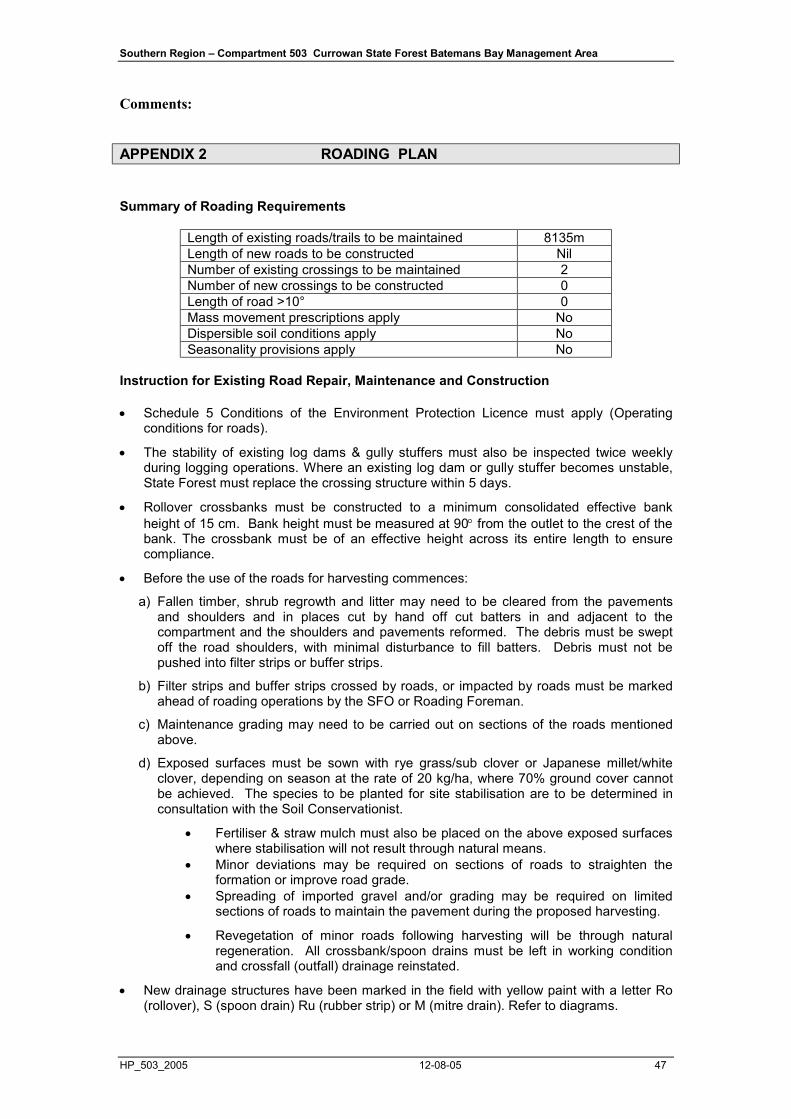
Southern Region – Compartment 503 Currowan State Forest Batemans Bay Management Area
HP_503_2005 12-08-05 47
Comments:
APPENDIX 2 ROADING PLAN
Summary of Roading Requirements
Length of existing roads/trails to be maintained 8135m Length of new roads to be constructed Nil Number of existing crossings to be maintained 2 Number of new crossings to be constructed 0 Length of road >10° 0 Mass movement prescriptions apply No Dispersible soil conditions apply No Seasonality provisions apply No
Instruction for Existing Road Repair, Maintenance and Construction
• Schedule 5 Conditions of the Environment Protection Licence must apply (Operating conditions for roads).
• The stability of existing log dams & gully stuffers must also be inspected twice weekly during logging operations. Where an existing log dam or gully stuffer becomes unstable, State Forest must replace the crossing structure within 5 days.
• Rollover crossbanks must be constructed to a minimum consolidated effective bank height of 15 cm. Bank height must be measured at 90° from the outlet to the crest of the bank. The crossbank must be of an effective height across its entire length to ensure compliance.
• Before the use of the roads for harvesting commences:
a) Fallen timber, shrub regrowth and litter may need to be cleared from the pavements and shoulders and in places cut by hand off cut batters in and adjacent to the compartment and the shoulders and pavements reformed. The debris must be swept off the road shoulders, with minimal disturbance to fill batters. Debris must not be pushed into filter strips or buffer strips.
b) Filter strips and buffer strips crossed by roads, or impacted by roads must be marked ahead of roading operations by the SFO or Roading Foreman.
c) Maintenance grading may need to be carried out on sections of the roads mentioned above.
d) Exposed surfaces must be sown with rye grass/sub clover or Japanese millet/white clover, depending on season at the rate of 20 kg/ha, where 70% ground cover cannot be achieved. The species to be planted for site stabilisation are to be determined in consultation with the Soil Conservationist.
• Fertiliser & straw mulch must also be placed on the above exposed surfaces where stabilisation will not result through natural means.
• Minor deviations may be required on sections of roads to straighten the formation or improve road grade.
• Spreading of imported gravel and/or grading may be required on limited sections of roads to maintain the pavement during the proposed harvesting.
• Revegetation of minor roads following harvesting will be through natural regeneration. All crossbank/spoon drains must be left in working condition and crossfall (outfall) drainage reinstated.
• New drainage structures have been marked in the field with yellow paint with a letter Ro (rollover), S (spoon drain) Ru (rubber strip) or M (mitre drain). Refer to diagrams.
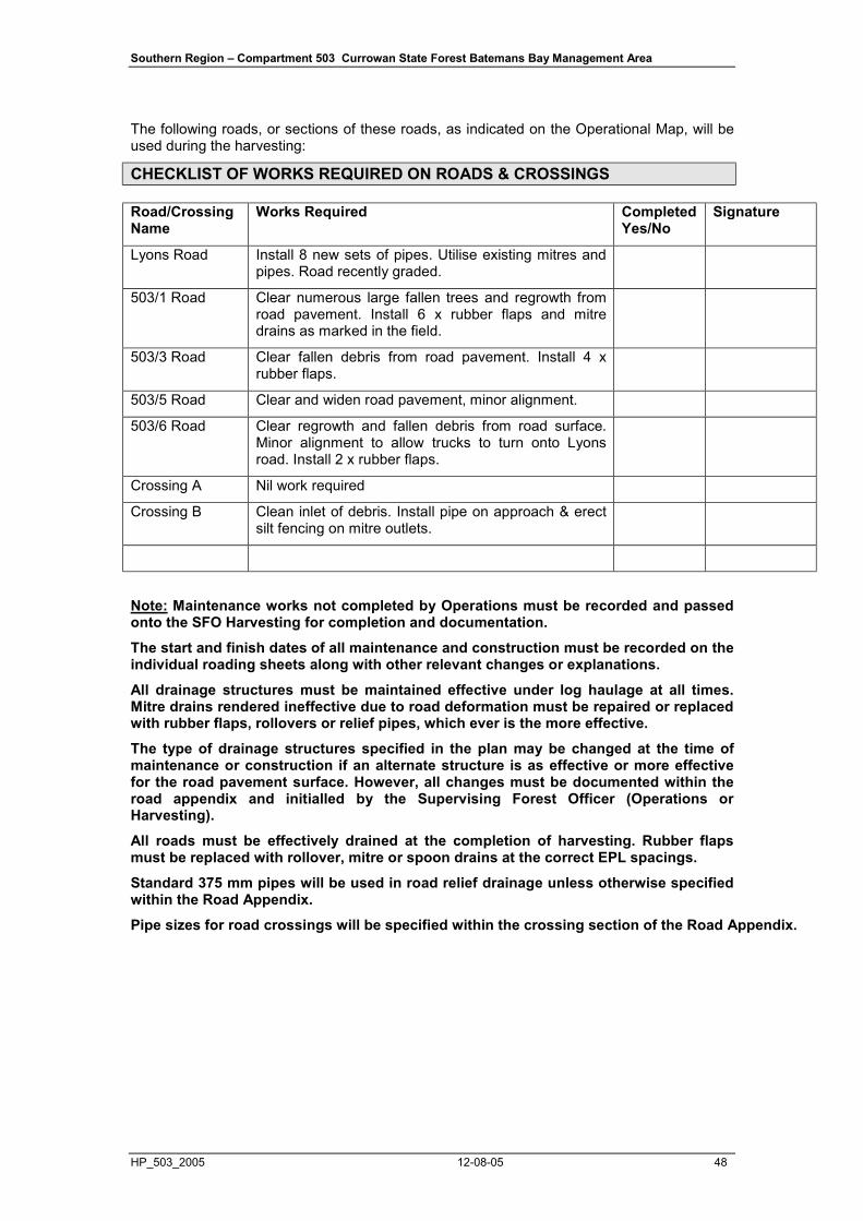
Southern Region – Compartment 503 Currowan State Forest Batemans Bay Management Area
HP_503_2005 12-08-05 48
The following roads, or sections of these roads, as indicated on the Operational Map, will be used during the harvesting:
CHECKLIST OF WORKS REQUIRED ON ROADS & CROSSINGS
Road/Crossing Name
Works Required Completed Yes/No
Signature
Lyons Road Install 8 new sets of pipes. Utilise existing mitres and pipes. Road recently graded.
503/1 Road Clear numerous large fallen trees and regrowth from road pavement. Install 6 x rubber flaps and mitre drains as marked in the field.
503/3 Road Clear fallen debris from road pavement. Install 4 x rubber flaps.
503/5 Road Clear and widen road pavement, minor alignment.
503/6 Road Clear regrowth and fallen debris from road surface. Minor alignment to allow trucks to turn onto Lyons road. Install 2 x rubber flaps.
Crossing A Nil work required
Crossing B Clean inlet of debris. Install pipe on approach & erect silt fencing on mitre outlets.
Note: Maintenance works not completed by Operations must be recorded and passed onto the SFO Harvesting for completion and documentation.
The start and finish dates of all maintenance and construction must be recorded on the individual roading sheets along with other relevant changes or explanations.
All drainage structures must be maintained effective under log haulage at all times. Mitre drains rendered ineffective due to road deformation must be repaired or replaced with rubber flaps, rollovers or relief pipes, which ever is the more effective.
The type of drainage structures specified in the plan may be changed at the time of maintenance or construction if an alternate structure is as effective or more effective for the road pavement surface. However, all changes must be documented within the road appendix and initialled by the Supervising Forest Officer (Operations or Harvesting).
All roads must be effectively drained at the completion of harvesting. Rubber flaps must be replaced with rollover, mitre or spoon drains at the correct EPL spacings.
Standard 375 mm pipes will be used in road relief drainage unless otherwise specified within the Road Appendix.
Pipe sizes for road crossings will be specified within the crossing section of the Road Appendix.