open-file report 159: geoloy of the northwestern gallinas ... · # open file rgport 159 geology of...
TRANSCRIPT

# OPEN FILE RGPORT 159
GEOLOGY OF THE NORTHWESTERN GALLINAS MOUNTAINS,
SOCORRO COUNTY, NEW MEXICO
Greg C. Coffin
Submitted in Partial Fulfillment
of the Requirements for the Degree of
Master of Science in Geology
New Mexico.Institute of Mining and Technology
Socorro, New Mexico
April, 1981
TABLE OF CONTENTS
ABSTRACT .............................................. i
INTRODUCTION .......................................... 1
Purpose of investigation ......................... 1
Location and Accessibility ....................... 2
Previous Investigations .......................... 4
Methods of investigation ......................... 7
Physiography ..................................... 8
Acknowledgements ................................. 9
STRATIGRAPHY AND PETROLOGY ........................... 11
Pre-Volcanic Rocks .............................. 11
Tertiary Volcanic Rocks ......................... 12
Datil Group ................................ 14
Spears Formation ........................... 14
The Dog Springs volcanic complex ....... 17 Lower Member ....................... 20
Upper Member ....................... 37
Genesis of the Dog Springs
volcanic complex ................... 70
Volcaniclastic Rocks of Chavez Canyon .. 81 Tuff of Rock House Canyon ............. 102 Middle Volcaniclastic Rocks ........... 109
Tuff of Blue Canyon ................... 118 Hells Mesa Tuff ........................... 126
Volcaniclastic Rocks of South Crosby Peak.136
A-L Peak Tuff ............................. 144
Lower Cooling Unit .................... 146
Interbedded Volcaniclastic Rocks ...... 151 Basaltic andesite of Twin Peaks ....... 154 Upper Cooling. Unit .................... 159
Younger Tertiary Rocks .................... 163
Intrusives ................................ 163
Surficial Deposits ............................. 167
STRUCTURE ........................................... 173
ALTERATION. MINERALIZATION AND ECONOMIC POTENTIAL ... 181 CONCLUSIONS ......................................... 187
Geologic Evolution of the northwestern
Gallinas Mountains ............................. 187
Stratigraphic Correlations ..................... 189
REFERENCES .......................................... 192
PLATES
I. Geologic Map and Sections of
the Western Gallinas Mountains,
Socorro County, New Mexico.................in pocket
11. Correlations of Major Ash-Flow
Sheets Along the Northern Margin
of the San Augustin Plains................in pocket
LIST OF TABLES
1. Modal analyses in volume percent
of the tuff of Blue Canyon.......................l24
2. Modal analyses in volume percent
of the Hells Mesa Tuff...........................l33
3. Modal analyses in volume percent
of the lower cooling unit of the
A-L Peak Tuff....................................l49
4. Modal analyses in volume percent
of the upper cooling unit of the
A-L Peak Tuff....................................l62
LIST OF FIGURES
1 - Diagram showing location of study area in west-central New Mexico...................3

2 - Composite stratigraphic column of the western Gallinas Mountains,
Socorro County, New Mexico.......................13
3 - Sketch map of distribution of rocks of the Dog Springs volcanic complex .............. 19
4 - Photograph of undulatory base of a typical tuff breccia in the lower
member of the Dog Springs volcanic
complex ........................................... 24
5 - Photograph of tuff breccia in the lower member of Dog Springs volcanic
complex .......................................... 24
6 - Photograph of tuff breccia of Martin Ranch in the lower member of the Dog
springs volcanic complex. ........................ 2 1
I - Photomicrograph of a typical clast of the tuff breccia of Martin Ranch
in the lower member of the Dog Springs
volcanic complex ................................. 28
8 - Photomicrograph of a typical heterolithic tuff breccia in the lower member of the
Dog Springs volcanic complex ..................... 3 3
9 - Photomicrograph of a monolithic andesite breccia in the lower member of the Dog
Springs volcanic complex.........................31
10 - Photograph of typical mudflow breccias in the upper member of the Dog Springs
volcanic complex ................................ 40
11 - Photograph of a massive outcrop of autobrecciated monolithic hornblende
andesite in the upper member of the
Dog Springs volcanic complex .................... 46
12 - Photograph of monolithic hornblende andesite breccia flow in the upper
member of the Dog Springs volcanic
complex ......................................... 47
13 - Photograph of monolithic hornblende andesite breccia dike in the Dog
Springs volcanic complex.......... .............. 48 14 - Photomicrograph of hornblende andesite
clast from the upper member of the Dog
Springs volcanic complex........................49
15 - Photograph of typical outcrop of the lacustrine rocks of Middle Canyon...............52
16 - Diagram of the stratigraphic distribution of exotic blocks in the Dog Springs
volcanic complex................................58
11 - Photograph of exotic block of limestone in the Dog Springs volcanic complex.............59
18 - Photograph of exotic block of crystal-rich, monolithic breccia
in the Dog Springs volcanic complex.............60
19 - Photomicrograph of crystal-rich, monolithic breccia from an exotic
block in the Dog Springs volcanic
complex.........................................65
20 - Diagram of the various elements of a detachment fault...........................69
21 - Diagram showing location of paleocurrent data...... ...................................... 89
22 - Rose diagrams of paleocurrent directions from the lower member of the volcaniclastic
rocks of Chavez Canyon..........................gO

23 - Rose diagram of paleocurrent directions from the upper member of the volcaniclastic
rocks of Chavez Canyon..........................gl
24 - Photograph of typical outcrop in the lower member of the volcaniclastic
rocks of Chavez Canyon..........................94
25 - Photograph of typical outcrop of the upper member of the volcaniclastic
rocks of Chavez Canyon..........................98
26 - Photograph of local unconformity between the upper and lower members
of the volcaniclastic rocks of
Chavez Canyon...................................gg
27 - Photograph of pervasively jointed outcrop of the tuff of Rock House
Canyon.........................................lO5
28 - Rose diagrams of paleocurrent directions from the middle volcaniclastic rocks...........llO
29 - Photograph of a typical outcrop of the middle volcaniclastic rocks................ll5
30 - Photograph of steeply dipping cross-stratified sandstones,
interpreted as dunes, near the top
of the middle volcaniclastic rocks.............ll6
31 - Photograph of the basal contact of the tuff of Blue Canyon. ........................... 121
32 - Photograph of a somewhat platy outcrop of the Hells Mesa Tuff.........................l28
33 - Photograph of the basal non-welded portion of the Hells Mesa Tuff.................l30
34 - Photograph of a typical outcrop of the tuff of South Crosby Peak...............l41
35 - Photograph showing the localization of the basaltic andesite of Twin
Peaks in a shallow paleodepression ............. 156 36 - Major structures and intrusive
rocks of the western Gallinas Mountains,
Socorro County, New Mexico.....................l65
37 - Development of reverse drag by flexure (a) rather than flexure (b)....................l77
38 - Photograph of the North Lake fault scarp.......l80
39 - Photograph of a calcite vein in the lacustrine rocks of Middle Canyon..........l82
40 - Photograph of hematite-magnetite veinlets in a mudflow deposit in
the upper member of the Dog Springs
volcanic complex...............................184

i
ABSTRACT
The western Gallinas Mountains have undergone a
complex geologic evolution similar to much of the
western United States during the Cenozoic era. Initial
early Oligocene (38 m.y. B.P.) intermediate volcanism
resulted in the formation of the Dog Springs volcanic
complex. The complex consists of tuff breccias,
monolithic volcanic breccias, mudflow deposits, exotic
blocks and minor interbedded sedimentary rocks. The
complex is similar to numerous other volcanic breccia
fields in the western United States.
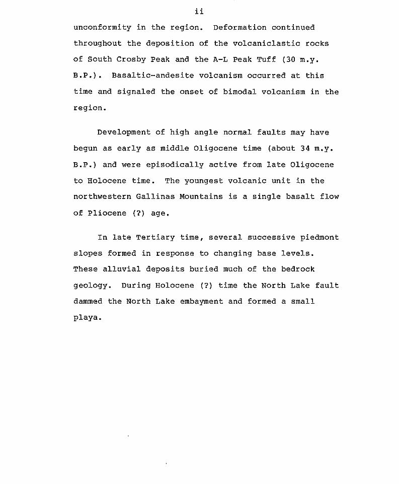
Towards the end of Dog Springs time (about 34 m.y.
B.P.) a depositional cycle was initiated during which
fluviatile sediments characteristic of a braided stream
environment were deposited. This cycle continued for
the next 2 million years with intermittent
interruptions during the emplacement of the tuff of
Rock House Canyon, the tuff of Blue Canyon and the
Hells Mesa Tuff.
Following the deposition of the Hells Mesa Tuff
( 3 3 m.y. B.P.) the formation of the Rio Grande rift
resulted in the development of a broad southeast
plunging syncline and an extensive surface of
ii
unconformity in the region. Deformation continued
throughout the deposition of the volcaniclastic rocks
of South Crosby Peak and the A-L Peak Tuff (30 m.y.
B.P.). Basaltic-andesite volcanism occurred at this
time and signaled the onset of bimodal volcanism in the
region.
Development of high angle normal faults may have
begun as early as middle Oligocene time (about 34 m.y.
B.P.) and were episodically active from late Oligocene
to Holocene time. The youngest volcanic unit in the
northwestern Gallinas Mountains is a single basalt flow
of Pliocene ( ? ) age.
In late Tertiary time, several successive piedmont
slopes formed in response to changing base levels.
These alluvial deposits buried much of the bedrock
geology. During Holocene (? ) time the North Lake fault
dammed the North Lake embayment and formed a small
playa.
INTRODUCTION
Purpose of the Investigation
The objectives of this thesis are to determine the
stratigraphic relationships, structural trends,
economic potential, and the distribution of various
rock units in the eastern half of the Dog Springs
7.5-minute quadrangle, Socorro County, New Mexico.
This thesis was undertaken as part of the New Mexico
Bureau of Mines and Mineral Resources extensive mapping
project of the northeastern portion of the
Datil-Mogollon volcanic province.
The previously cited objectives are important for
the following reasons:
1. The stratigraphic relationships will provide
further data for correlating rock units between
previously mapped areas in the Bear, Gallinas,
Datil, Crosby, Magdalena, and San Mateo Mountains.
2. An analysis of structural trends will provide
a framework for mineral exploration within the
area and may serve to define part of the
structural margin of an inferred volcanic complex.
3. Distribution of the various rock units in the
area will provide a data base with which to
interpret the geologic history of the region and
with which to put some boundaries on the aerial
extent of the inferred volcanic complex.
Location and Accessibility
The eastern portion of the Dog Springs 7.5-minute
quadrangle is located approximately sixty-five
kilometers northwest of Magdalena, New Mexico (fig.1).
The map area is a rectangular region of about
seventy-eight square kilometers occupying the eastern
half of the Dog Springs quadrangle. The northern
portion of the area is in the Cibola National Forest
and the southern portion is on private land owned by
the HH Ranch. The area is bounded by 34 22' 30" N.
latitude on the north, 34 15' N. latitude on the
south, 107 37' 30" W. longitude on the east, and 107
41' 15" W. longitude on the west.
Good access to the area is provided by a light
duty Forest Service road, numerous unimproved roads and
jeep trails. High clearance vehicles are required for
unimproved roads and jeep trails. Four-wheel-drive is
required in wet weather.
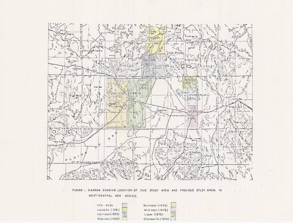
4 FIGURE I. DIAGRAM SHOWINO LOCATION OF .‘IIIIS’ STUDY AREA AND PREVIOUS STUDY AREAS IN
WEST-CENTRAL .NEW MEXICO.
1 h i s a ludy Laroeha 11981)
Burnhorll’ l l976)
Wilkinlan 11976) tlatrlso”1i900) L ~ P ~ Z (1975) !
Robinron(1900) Chombarlln( 1974)
Previous Investigations
Previous geologic investigations of the Gallinas
Mountains have been mostly of a reconnaissance nature.
The earliest recorded work was by Herrick (1900) who
undertook a geologic reconnaissance of the western
portion of Socorro and Valencia Counties. He briefly
mentioned that the Bear, Gallinas and Datil Mountains
consisted of trachytic and rhyolitic intrusives.
Winchester (1920) conducted a geologic investigation of
the Alamosa Creek area, now the Rio Salado, located to
the north of the studied region. Winchester reported a
series of tuffs, rhyolites, conglomerates and
sandstones unconformably overlying Cretaceous rocks.
He further described a type section of the Tertiary
rocks located in the northern Bear Mountains and named
the entire Tertiary section the Datil Formation.
Powers (1939 and 1941) investigated the geomorphology
of extinct Lake San Augustin and the volcanic rocks of
San Augustin Plains.
Loughlin and Koshman (1942) published a detailed
report on the Magdalena mining district. Wilpolt and
others (1946) removed the lower 208 m from Winchester’s
Datil Formation and named it the Baca Formation for
exposures in Baca Canyon in the northern Bear
Mountains. Givens (1957) and Tonking (1957) completed
geologic maps of the Dog Springs and Puertecito
15-minute quadrangles, respectively. Tonking divided
the Datil Formation into the Spears, Hells Mesa and La
Jara Peak Members. Givens divided the Datil Formation
into the Spears Ranch and Hells Mesa Members following
Tonking but reported no unit correlative to Tonkings’
La Jara Peak Member. Givens further subdivided the
Hells Mesa member into 7, lithologically distinct
mappable units. Willard (1959) correlated the La Jara
Peak Member to the post-Datil Mangas basalt located in
Catron County. Weber (1963) separated the La Jara Peak
Member from the Datil Formation. Later Weber (1971)
elevated the Datil Formation to group status. Chapin
(1971a) elevated the La Jara Peak, Hells Mesa, and
Spears members of the Datil Group to formational
status.
More recently numerous thesis investigations by
graduate students of the New Mexico Institute of Mining
and Technology and the University of New Mexico have
provided information concerning the area. Brown (1972)
completed a detailed map of the southern Bear Mountains
and presented a detailed analysis of the petrography
and stratigraphy of the area. He divided the Hells
Mesa Formation into the tuff of Goat Springs and the
tuff of Bear Springs. Simons (1973), Chamberlin
(1974), Wilkinson (1976), Laroche (1980) and Harrison
(1980) have all undertaken detailed mapping projects in
the area surrounding this study (fig.1). Deal (1973)
did reconnaissance mapping in the northern San Mateo
Mountains. Lopez (1975) and Bornhorst (1976) did
reconnaissance mapping in the Datil area.
Numerous other studies have also been completed.
Elston and others (1968, 1970, 1973, and 11976) have
tried to place the Datil-Mogollon volcanic province
into an overall volcano-tectonic framework of the
western United States. Chapin (1974) restricted the
Hells Mesa Formation to Brown’s tuff of Goat Springs.
Deal and Rhodes (1976) renamed the tuff of Bear Springs
the A-L Peak Tuff. Elston (1976) reviewed the
significance of mid-Tertiary volcanism in the Basin and
Range province.
Several workers have determined radiometric dates
for the units of the Datil-Mogollon volcanic province.
Weber and Bassett (1963) dated biotite from the basal
portion of Tonkings’ type section of the Hells Mesa
Member. Burke and others (1963) dated a latite boulder
in the Spears Formation and two welded samples from the
Hells Mesa Tuff. Kottlowski, Weber and Willard (1969)

published radiometric dates of Cretaceous and Tertiary
igneous rocks of New Mexico. Weber (1971) published
five more dates of Tertiary igneous rocks from central
New Mexico. Chapin (1971a) reported a date for the La
Jara Peak Formation. Elston and others (1973) compiled
a summary of all available K-Ar dates for the
Datil-Mogollon volcanic province. E . I . Smith and
others (1976) provided eight fission track dates for
volcanic and plutonic rocks of the Mogollon Plateau.
Methods of Investigation
Geologic mapping at a scale of 1:24,000 using the
United States Geological Survey Dog Springs 7.5-minute
quadrangle as a base map was undertaken throughout the
second half of 1979 and the spring and fall of 1980.
United States Forest Service color aerial photographs
of the F16-CIB series, 1974-1975, at an approximate
scale of 1:17,000 were used to locate and delineate
rock units. Aerial photos also proved valuable in the
analysis of structural trends and geomorphic features
Forty samples from throughout the study area were
collected for petrographic analysis. Modal analysis
and staining for potassium feldspar were performed on
selected slides. Modal analyses were conducted using a

Zeiss binocular microscope and a Swift automatic point
counter. A minimum of 2000 points were counted per
thin section. Staining of potassium feldspar was done
following the standard procedures outlined by Deere,
' Howie and Zussman (1976, p.311). Anorthite content of
plagioclase was determined with the universal stage
(Rittman Zone Method) utilizing the high temperature
curves of Troger (1959) and following the Michel-Levy
statistical method as outlined by Heinrich (1965,
p.360). Rock names were chosen following Travis (1953)
and Williams, Turner and Gilbert (1954). Rock colors
were determined using the Geologic Society of America
Rock Color Chart.
Samples for radiometric dating of several units
were collected and results are presented in the text
when available.
Physiography
The study area occupies the nose of a broad
northwest-trending, southeast-plunging syncline.
Topographically, the area is a low saddle of
south-facing dip slopes connecting the Datil and
Gallinas Mountains. The southern portion of the study
area is occupied by the North Lake Basin and the
northeastern arm of the Plains of San Augustin. The
study area is located in the northeastern portion of
the Datil-Mogollon volcanic province on its’ boundary
with the Colorado Plateau.
Acknowledgments
I gratefully acknowledge the contributions of all
the people who made the completion of this project
possible. Jay Taylor, owner of the HH Ranch, allowed
access to his property. Richard Harrison provided
ideas and information during numerous discussions and
field trips. A.G. Raby provided field assistance for
the interpretation and description of the sedimentary
rock units. Glenn R. Osburn provided field and office
assistance during the preparation of this report. Dr.
John Hawley and Dr. Robert Weber assisted in the
interpretation of upper Tertiary and Quaternary units.
Dr. Clay T. Smith and Dr. David I. Norman
critically reviewed the manuscript and served on the
thesis committee. A special thanks is extended to Dr.
Charles E. Chapin who suggested the project and served
as the thesis committee chairman. The New Mexico
Bureau of Mines and Mineral Resources provided
financial support and paid for all lab expenses
incurred during the study.

I would a l s o l i k e t o t h a n k my fami ly and my many
f r i e n d s who provided moral support dur ing t h e course of
t h i s p r o j e c t . I would e s p e c i a l l y l i k e t o t h a n k my
p a r e n t s who encouraged me to pursue a graduate degree.
STRATIGRAPHY AND PETROGRAPHY
Pre-volcanic Rocks
No pre-volcanic units are exposed in the study
area. Permian limestones occur as exotic blocks in the
Dog Springs volcanic complex but these blocks will be
discussed with rocks of the Spears Formation.
Upper Cretaceous age rocks of the Mesaverde Group
crop out approximately 6.5 km to the northwest (Givens,
1957) and 14 km to the east of the study area (Tonking,
1957). More recent studies concerning pre-volcanic
rocks within the region have been undertaken by
Massingill (1979) , Mayerson (1979) , Cather (1980) , Jackson (in prep) and Robinson (1980) .
Late Eocene beveling of central New Mexico by
erosion produced a surface of low topographic relief
prior to the onset of Oligocene volcanism (Epis and
Chapin, 1975). Eocene rocks of the Baca Formation are
exposed 3 km to the north of the study area. The Baca
Formation formed during the erosion of Laramide uplifts
and the subsequent deposition of debris in adjacent
basins (Snyder, 1971). Contact relationships of the
Baca Formation with the overlying volcanic rocks of the
Spears Group vary from conformable near the center of
the basin to unconformable near the basin margin.
Tertiary Volcanic Rocks
The majority of the study area is occupied by
Tertiary age ash-flow tuffs, volcanic breccias, mudflow
deposits and interbedded volcaniclastic rocks.
Basaltic-andesite lava flows make up a subordinate
portion. This relationship is in direct contrast to
the Bear Mountains east of the study area where
basaltic-andesite flows are much more common. A
maximum exposed thickness of 1166 m of Tertiary
volcanic rocks is present in the study area. These
include volcanic source areas, outflow facies ash-flow
tuffs, and alluvial aprons surrounding volcanic
centers.
All volcanic rocks, with the possible exception of
the uppermost basalt flow, are thought to be of
Oligocene age. Major units from oldest to youngest are
the Datil Group, the Hells Mesa Tuff and the A-L Peak
Tuff. The A-L Peak Tuff unconformably overlies the
Hells Mesa Tuff which conformably overlies the Datil
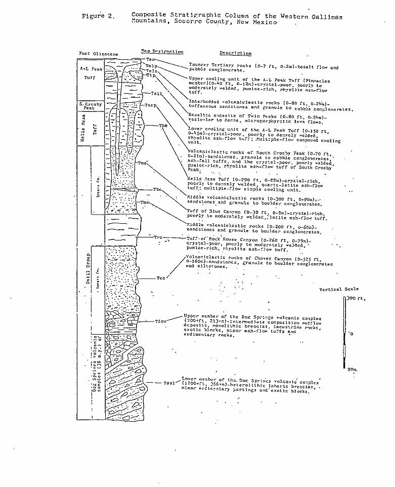
Group (fig. 2) .
00 rt ,
0
IO?.
Datil Group
In this study all units above the Baca Formation
and below the Hells Mesa Tuff are collectively referred
to as the Datil Group, following the proposal of
Chapin, and others (in prep) . The units in this
interval were previously referred to as the Spears
Formation, but for reasons discussed below this
terminology has been abandoned. In the study area the
Datil Group consists of the Dog Springs volcanic
complex, the Spears Formation, the tuff of Rock House
Canyon and the tuff of Blue Canyon.
Spears Formation
The Spears Formation was divided into upper and
lower members by Brown (1972). The members are
separated by the tuff of Nipple Mountain which has been
correlated to the tuff of Rock House Canyon (this
report) and the tuff of Main Canyon (Harrison, 1980).
The lower member as described to the east of the study
area consists of latitic to andesitic conglomerates and
sandstones (Brown, 1972), quartz latite tuffs,
breccias, siltstones, claystones (Tonking, 1957), and
minor autobrecciated lava flows (Chamberlin, 1974).
The upper member, east of the study area, consists of
latitic to andesitic flows, crystal-rich, quartz-poor,
ash-flow tuffs (Wilkinson, 1976), mudflow breccias
(Chamberlin, 1974); conglomerates and sandstones
(Tonking, 1957). Within, and to the west of the study
area, the lower member consists of a sequence of
intermediate-composition tuff breccias, mudflow
deposits, monolithic volcanic breccias, exotic blocks,
mudstones, minor fluviatile sedimentary rocks and minor
ash-flow tuffs. This sequence lies below an interval
of tuffaceous sandstones and conglomerates which
underlie the tuff of Rock House Canyon. The upper
member, within and to the west of the study area,
consists of a single latitic ash-flow tuff, the tuff of
Blue Canyon, intercalated within a sequence of
volcaniclastic sandstones and conglomerates. Clearly
distinct lithologic and stratigraphic differences exist
between the Spears age rocks in and to the west of the
study area and the Spears age rocks to the east of the
study area (Plate 11). These differences' led Harrison
(1980) to propose that the Spears Formation be raised
to group status and that the volcaniclastic rocks and
ash-flow tuffs within it be raised to formational
status. This scheme would involve the naming of all of
the volcaniclastic rocks, which have traditionally been
called the Spears Formation, but would also eliminate
the excess verbiage when referring to the regionally
extensive ash-flow tuffs within the Spears Formation
(Chapin and others, in prep). Chapin and others (in
prep) have recently proposed that the term Spears
Formation be reserved for the volcaniclastic rocks in
the post-Baca--pre-Hells mesa interval and that the
interbedded ash-flow tuffs in this interval be given
separate names and formational status. Furthermore
they have also proposed that the interval be
collectively referred to as the Datil Group. For the
sake of clarity a similar scheme has been followed
here. However regionally extensive volcaniclastic
units that have clear-cut upper and lower contacts have
been given informal names.
Within the study area, the Datil Group has been
divided into six units. The units in ascending order
are the lower member of the Dog Springs volcanic
complex, the upper member of the Dog springs volcanic
complex, the volcaniclastic rocks of Chavez Canyon, the
tuff of Rock House Canyon, the middle volcaniclastic
rocks and the tuff of Blue Canyon, which is
intercalated within the middle volcaniclastic rocks.
The Spears Formation consists of the volcaniclastic
rocks of Chavez Canyon and the middle volcaniclastic
rocks.
The Dog Springs volcanic complex
The Dog Springs volcanic complex is an informal
name proposed for a sequence of, volcanic breccias,
minor mudstones, ash-flow tuffs, exotic blocks, and
fluviatile conglomerates and sandstones. The unit is
correlative to portions of Tds as described by Givens
(1957) , portions of the latite facies of the Datil
Formation as described by Willard (1963), the mudflow
breccia and conglomerates of Bornhorst (1976) and the
lower portion of the Spears Formation as described by
Lopez (1975).
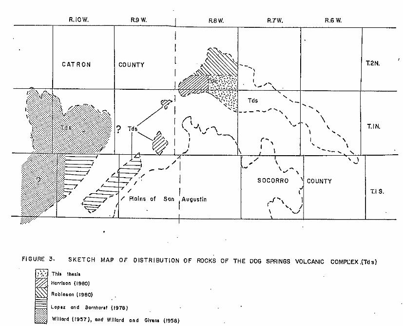
The rocks of the Dog Springs volcanic complex are
regionally extensive and form much of the northern
margin of the Gallinas and Datil Mountains. The Dog
Springs volcanic complex has been reported as far east
as the northwest Gallinas Mountains, as far west as the
Sawtooth Mountains (this report) , as far north as Martin Ranch (Robinson, 1980) and as far south as
Flying Draw (Bornhorst, 1976). The unit pinches out to
the east of the study area: however Spradlin (1973)
reported a hornblende-rich tuff in the Joyita Hills
that is similar to some rocks in the Dog Springs
volcanic complex. Reconnaissance in the Sawtooth
Mountains, which form prominent bluffs visible from

U.S. Highway 60 northwest of Datil, revealed that the
bluffs are thick sequences of tuff breccias similar to
the tuff breccias in the Dog Springs volcanic complex.
Reconnaissance to the east of the study area has shown
that the rocks of the Dog Springs volcanic complex
extend to the northeast corner of the Gallinas
Mountains (fig. 3) . The Dog Springs volcanic complex crops out as
rounded hills, often covered by gravels, and as
south-facing dip slopes. Outcrops are transected by
north and east trending canyons which have moderately
to steeply sloping walls. The majority of the unit is
covered by talus, colluvium, alluvium and regolith.
Some of the steeper slopes and more deeply eroded
valleys provide outcrops of the less resistant units
which are otherwise not seen.
The basal contact of the unit is not exposed
anywhere in the study area. Reconnaissance in the
Sawtooth Mountains and the Gallinas Mountains indicates
that the basal contact is conformable with the
underlying Baca Formation, but local unconformities,
possibly due to soft sediment deformation, have been
observed. The upper contact of the unit with the
volcaniclastic rocks of Chavez Canyon is not exposed in
the area, but attitudes indicate that the contact is an
angular unconformity. However, some of the upper parts
of the unit strongly resemble the overlying sandstones
and conglomerates and therefore the contact may locally
be gradational. Harrison (1980) reported that the
upper contact was an angular unconformity.
Within the study area the unit has been divided
into two distinctive assemblages of rocks referred to
as the upper and lower members of the Dog Springs
volcanic complex. The lower member consists of tuff
breccias, minor exotic blocks and volcaniclastic rocks.
The upper member consists of monolithic andesite
breccias, mudflow breccias, lacustrine rocks, and
exotic blocks. Individual rock types have been mapped
within the members wherever sufficient outcrop was
present.
Lower Member
The lower member of the Dog Springs volcanic
complex consists of intermediate-composition, tuff
breccias and minor volcaniclastic rocks. The term tuff
breccia is adopted from Parsons (1967) and refers to
"volcanic breccias with a large percentage of tuffaceous
matrix". The term tuff breccia is favored over other
..
.
.
..
3: rq U
.
..
..
..
.
..
.
.
.. . .!
""_ -
z 0
n
I- 0 a
I
... p~
l~
< .
'~
...... ...... ...... .....
-. ...... ...... ...... ...... ......
3
...
terms because it is descriptive rather than genetic.
The lower member is equivalent to the tuff breccias of
Harrison (1980), portions of the Spears Formation as
described by Lopez (1975) and Bornhorst (1976) , and portions of the latite facies of the Datil Formation as
described by Willard (1963). No source has been
determined for the lower member within the study area.
A K-Ar date on a clast from the lower member yielded an
age of 38 m.y. B.P. (C.E. Chapin, unpublished data).
Similar looking rocks have been observed during
reconnaissance as far north as Martin Ranch
(Sec.15,T.2N., R.8W.), as far east as North Basin Well
(Sec.18,T.lN. ,R.7W) I as far west as the Sawtooth
Mountains (Sec.7,T.lN. ,R.llW.), and as far south as
Main Canyon (Sec.27, T.lS.,R.lOW.). Spradlin
described a hornblende rich tuff from the Joyita Hills
of similar composition.
The lower member covers approximately 3.9 square
kilometers of' the study area and is volumetrically
subordinate to the upper member in this area. The
lower member forms a discontinuous outcrop pattern
south of the Chavez Well-Thompson Canyon fault and
along the northern boundary of the study area.
Outcrops of the lower member occur along ridges, in
drainages and on hillsides, but rarely exceed 150 m in
maximum dimension. The lower member has a maximum
exposed thickness of 370 m in the study area.
Reconnaissance to the north and east of the study
area has revealed that the lower member forms a
physiographically distinct, volumetrically significant,
northeast-trending outcrop belt approximately 3 to 6 km
wide and 30 km long that forms the northeast margin of
the Gallinas Mountains. The region is characterized by
steeply sloping hills with several hundred meters of
relief occupying approximately 130 square kilometers.
The hills characteristically have large blocks of tuff
breccia exposed on their tops and sides. A maximum
estimated thickness of 600 m of the lower member is
exposed in the region.
The lower member consists of
intermediate-composition rocks that are mineralogically
and petrographically similar to the overlying upper
member of the Dog Springs volcanic complex. Distinct
differences, however, exist between the members when
viewed in outcrop and hand specimen. Outcrops of the
lower member tuff breccias display non-sorted clasts
ranging in size from 4 mm to 2 m in diameter.
Individual flows are discernible and impart a layering
to the tuff breccias, but no stratification is apparent
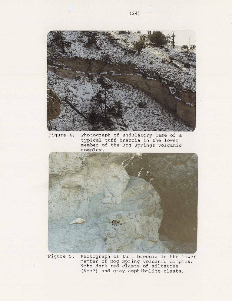
within the flows themselves. The bases of the
individual flows have irregular surfaces (fig.4).
This can be explained by the presence of load
deformation and/or channeling. Outcrops of the lower
member are more resistant than most of the units in the
upper member and tend to form steeper hills with more
exposure. Bedding planes are much easier to recognize
in the lower member than in the upper member, however
bedding is often chaotic due to soft-sediment
deformation.
Clasts are predominantly porphyritic andesites
which tend to be less dense and lighter in color than
rocks of similar composition in the overlying upper
member. No vesicular material or glass was observed in
hand specimen or in thin section in the lower member.
A few clasts of Precambrian granitic rocks and
amphibolites, and Late Paleozoic limestones and red
sandstones and siltstones were observed in the lower
member. These non-volcanic clasts rarely exceed a few
centimeters in maximum dimension and are volumetrically
minor (fig.5) . Harrison (1980) and Osburn (oral commun., 1980) have both observed large limestone
blocks in similar units outside of the study area;
however, only one large block was observed in the lower
member within the study area. The heterolithic nature
of the tuff breccias in the lower member, especially
near the top of the member, is not so much revealed by
large variations in clast composition as by variations
in texture, color and degree of weathering displayed by
clasts of similar composition. Parsons (1969)
described similar relationships in tuff breccias of the
Absaroka volcanic field.
Matrix in the tuff breccias consists of lithic
fragments, crystal fragments, and aphanitic material.
Matrix varies in color from light gray to reddish brown
and is compositionally very similar to the fragments.
Generally clasts can be distinguished from the
surrounding matrix by color and tonal differences,
however sometimes they are so similar that only the
igneous textures displayed by the clasts serve to
distinguish them.
The lower portion of the lower member
predominantly consists of tuff breccias that have a
dominant lithologically distinct clast type. These
tuff breccias are informally referred to as the tuff
breccia of Martin Ranch (fig.6) for good exposures of
the unit just south of Martin Ranch (Sec.15, T.2N.,
R.8W.l. The predominant clast type which serves to
distinguish the tuff breccia of Martin Ranch is a
light-gray porphyritic andesite with conspicuous
phenocrysts of hornblende, milky-white feldspar and
minor phenocrysts of biotite set in an aphanitic
groundmass. Amphibolites occur as exotic clasts in the
tuff breccia and as xenoliths in the fragments of the
tuff breccia.
Petrographically, the clasts in the tuff breccia
of Martin Ranch are seriate, porphyritic, and contain
in decreasing order of abundance, phenocrysts of
plagioclase, hornblende, biotite and magnetite.
Phenocrysts account for 4 0 to 45 percent of the rock by
volume and range in size from 0.2 mm to 4.0 mm in
maximum dimension. The groundmass consists of low
birefringent greenish-gray cryptocrystalline material
(fig.7).
Euhedral to subhedral laths of plagioclase, 0.2 mm
to 4.0 mm in length, occurring singly and in clusters,
account for 20 to 25 percent of the rock by volume.
Plagioclase crystals exhibit normal, reversed and
oscillatory zoning. Albite and carlsbad twins are
common: pericline twins are rare. Margins of
plagioclase phenocrysts are sharp, corroded or rounded,
and rarely embayed. Cores of some plagioclase
F i g u r e 6. Photograph of t u f f b r e c c i a of Mar t in Ranch i n t h e lower member of the Dog Springs volcanic complex. Note mono l i th i c and unso r t ed na tu re of t h e u n i t .
Figure 7 . Photomicrograph of typical clast of the tuff breccia of Martin Ranch in the lower member of the Dog Springs volcanic complex. Phenocrysts are plagioclase (P) , hornblende (H) and plagioclase phenocryst in the center of biotite (B). Note zoned inclusions in
the photomicrograph.

phenocrysts have been removed; other plagioclase
phenocrysts contain zoned inclusions with dusty borders
(fig.7). Anorthite content of plagioclase was
determined for 6 grains (Rittman Zone Method) which
yielded an average value of An22 (oligoclase).
Euhedral, light-green or clear inclusions of apatite,
randomly oriented and with their long dimensions
parallel to cleavage, are common within plagioclase
phenocrysts.
' Subhedral to euhedral hornblende phenocrysts, 1.5
mm in maximum dimension, account for 18 to 22 percent
of the rock by volume. Hornblende is pleochroic and
ranges in color from yellowish brown to greenish brown.
Hornblende occurs as elongate laths and six-sided cross
sections typical of amphiboles. Rims are corroded,
embayed and commonly mantled by opaque minerals.
Hornblende phenocrysts are commonly zoned, twinned and
occasionally replaced by biotite.
Biotite also occurs as subhedral to euhedral laths
1.0 mm in maximum dimension and accounts for
approximately 4 percent of the rock by volume. Biotite
is pleochroic and displays colors ranging from dark
brown to golden-yellow brown. Biotite also exhibits
color zonation within individual crystals; cores are
commonly l i g h t e r t h a n rims. Margins of b i o t i t e
p h e n o c r y s t s a r e commonly cor roded and o c c a s i o n a l l y
embayed. Magnet i te occurs as subhedra l t o euhedra l
cubes 0.4 mm i n maximum dimension and accoun t s fo r
about 1 p e r c e n t of t h e rock by volume. Phenocryst of
m a g n e t i t e o c c u r a s s i n g l e c r y s t a l s and i n c lusters .
M a g n e t i t e a l s o occurs as man t l e s on hornblende
phenocrys ts .
Above t h e t u f f b r e c c i a of Mar t in Ranch is a
sequence of b i o t i t e - r i c h , h e t e r o l i t h i c , t u f f b r e c c i a s
and m o n o l i t h i c v o l c a n i c b r e c c i a s of i n t e r m e d i a t e
composi t ion . Al though s imi la r i n outcrop
c h a r a c t e r i s t i c s to t h e u n d e r l y i n g t u f f b r e c c i a o f
Mart in Ranch t h e s e b r e c c i a s c a n b e d i s t i n g u i s h e d by
t h e i r c h a r a c t e r i s t i c c l a s t c o n t e n t . The h e t e r o l i t h i c
t u f f b r e c c i a h a s a l l of t h e clast c h a r a c t e r i s t i c s of
t h e u n d e r l y i n g t u f f b r e c c i a of Mar t in Ranch and b i o . t i t e
a n d e s i t e clasts t h a t h a v e p h e n o c r y s t s of f e l d s p a r ,
b i o t i t e and hornblende . The monol i th ic b recc ia can be
d i s t i n g u i s h e d b y t h e d e n s e , d a r k , s u b a n g u l a r c l a s t s
which appear to be d e r i v e d from lava f l ows or
hypabyssa l rocks ra ther than f rom t u f f s . Although
s i m i l a r to t h e o v e r l y i n g a n d e s i t e b r e c c i a s .of t h e upper
member of t h e Dog S p r i n g s v o l c a n i c c o m p l e x , t h e
m o n o l i t h i c b r e c c i a c a n b e d i s t i n g u i s h e d by t h e l a r g e r
percentage of matrix material which is
characteristically dull-red in color. The monolithic
breccia also seems to be altered very easily and often
appears to be propylitized. Manganese staining is also
characteristic of the altered portions of the
monolithic breccia.
In hand specimen and outcrop, the heterolithic
tuff breccias of the lower member are light brown to
buff when weathered and light to medium gray when
fresh. Clasts are angular to subrounded and range in
color from gray to buff. Clasts range in size from ash
to blocks (Fisher, 1960) and show little or no sorting.
Igneous clasts consisting of hornblende andesites,
identical to those in the underlying tuff breccia of
Martin Ranch, and biotite andesites make up over 99
percent of the clast content by volume. The
heterolithic breccias are moderate to well-indurated
and crop out as discontinuous beds.
Petrographically, the tuff breccia consists of
porphyritic clasts of intermediate composition set in a
light-brown matrix of cryptocrystalline material,
crystal fragments, lithic fragments and minor opaque
material which is compositionally similar to the clasts
it encloses. Porphyritic clasts can be distinguished
from the surrounding matrix by their tonal differences
and poorly developed pilotaxitic texture (fig.8). Only
hornblende andesite and biotite andesite clasts, which
volumetrically dominate the total clast content, were
observered in thin section.
Biotite andesite clasts possess, in decreasing
order of abundance, phenocrysts of plagioclase,
biotite, hornblende and sanidine set in a groundmass of
low birefringent cryptocrystalline material. Clasts
are approximately 40 percent phenocrysts.
Subhedral to euhedral phenocrysts of plagioclase
account for about 23 percent, by volume, of.the biotite
andesite clasts. Plagioclase phenocrysts occur singly
and in aggregates and do not exceed 3.0 mm in maximum
dimension. Plagioclase displays carlsbad, pericline
and albite twinning. Phenocryst margins may be either
sharp or corroded. Phyllosilicate alteration is common
on plagioclase phenocrysts. Anorthite content of
plagioclase (Rittman Zone Method) is about An 23
(oligoclase).
Biotite which accounts for about 14 percent of the
biotite andesite clasts by volume is subhedral and
mantled or totally replaced by magnetite. Biotite is
1.2 mm in maximum dimension and, when unaltered,
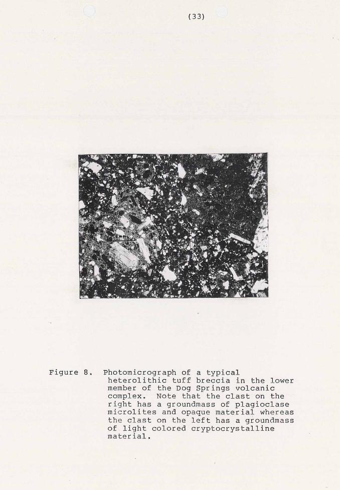
Figure 0. Photomicrograph of a typical
member of the Dog Springs volcanic heterolithic tuff breccia in the lower
complex. Note that the clast on the
microlites and opaque material whereas right has a groundmass of plagioclase
of light colored cryptocrystalline the clast on the left has a groundmass
material.

exhibits pleochroic colors ranging from pale yellow to
dark reddish brown. Subhedral to euhedral hornblende
is 0.4 mm in maximum dimension and displays pleochroic
colors ranging from golden-yellow to dark reddish
brown. Hornblende accounts for 3 percent of the rock
by volume. Trace amounts of sanidine are also present.
In hand specimen, the monolithic andesite breccia
of the lower member is reddish brown when weathered and
consists of gray clasts surrounded by a dull-red matrix
when fresh. Subangular clasts rarely exceed a few
centimeters in maximum dimension and display
phenocrysts of feldspar and hornblende in a light-gray
aphanitic matrix. This rock type is volumetrically
minor within the study area but is widespread
throughout the region. The monolithic andesite
breccias of the lower member are correlative to the
laharic breccias of Harrison (1980) . Petrographically, the monolithic hornblende
andesites of the lower member of the Dog Springs
volcanic complex are porphyritic and contain in
decreasing order of abundance phenocrysts of
plagioclase, hornblende, biotite, clinopyroxene,
magnetite and sanidine. Groundmass consists of low
birefringent cryptocrystalline material, chlorite,

felted plagioclase microlites and opaque material.
Phenocrysts account for approximately 24 percent of the
rock by volume. Clasts account for 20 to 80 percent of
the rock by volume and are surrounded by a dull-red
matrix of crystal fragments, low birefringent
cryptocrystalline material, chlorite, and opaque
material (fig .9 ) . Plagioclase is by far the most abundant phenocryst
present and accounts for approximately 12 percent of
the rock by volume. Plagioclase phenocrysts are 2.0 mm
in maximum dimension and display albite, carlsbad and
pericline twinning. Plagioclase is anhedral to
euhedral and displays normal, reversed and oscillatory
zoning. Margins of plagioclase phenocrysts are
corroded or sharp. Anorthite content of plagioclase
was determined using the Michel-Levy statistical method
which yielded a value of An 48 (andesine).
Euhedral to subhedral hornblende phenocrysts
account for 5 percent of the rock by volume and are 0.5
mm in maximum dimension. Hornblende is commonly
partially or totally replaced by phyllosilicate
minerals and magnetite. Biotite phenocrysts account
for 2 percent of the rock by volume and rarely exceed
0.5 mm in maximum dimension. Biotite phenocrysts are

Figure 9. Photomicrograph.of a monolithic andesite breccia in the lower member of the Dog Springs volcanic complex.
subhedral and elongate. Biotite is commonly replaced
or mantled by magnetite and displays pleochroic colors
ranging from light to medium green. Clinopyroxene
accounts for 2 percent of the rock by volume and occurs
as anhedral to subhedral blebs 0.4 mm in maximum
dimension. Magnetite occurs as anhedral.to subhedral
cubes and accounts for one percent of the rock by
volume. Chlorite occurs as anhedral masses in the
groundmass and accounts for 1 percent of the rock by
volume. Trace amounts of sanidine 0.5 mm in maximum
dimension are also present. Sanidine displays sharp or
corroded margins and carlsbad twinning.
Upper Member
The upper member of the Dog Springs volcanic
complex consists of hornblende andesite breccias,
intermediate-composition mudflow deposits, mudstones,
exotic blocks, minor volcaniclastic rocks and ash-flow
tuffs. The member represents part of the vent facies
of the Dog Springs volcanic complex. No date has been
determined for the member.
The upper member has been mapped as far north as
the mouth of Middle Canyon (Sec.21, T.2N., R.8W.) and
as far south as the head of Middle Canyon (Sec. 12 ,
T.lN., R.8W.) (this report). The member has been
observed during reconnaissance as far south and west as
eastern Catron County (Sec.'30, T.lN., R.9W.) and as far
east as the central Gallinas Mountains (Sec.10 T.lN.,
R.7W.). The upper member is not as regionally
extensive as the lower member and may represent
deposits that were localized in a volcano-tectonic
depression.
The upper member forms a distinctive terrain
within, and to the east of, the study area
characterized by low, flat-topped hills which rarely
exceed 60 m in relief. The upper member forms isolated
outcrops on hill sides and tops and in recently eroded
stream drainages. The abundance of outcrops of a
particular rock type within the member is relative to
resistivity to weathering and abundance. A maximum
thickness of 215 m of the upper member is exposed in
the study area. The upper member forms two continuous
bands across the northern and north-central portions of
the study area and covers approximately 10 square
kilometers.
mudflow deposits
Mudflow deposits occur throughout the upper member
and are thought to be the most common rock type. The
mudflow deposits appear to have gradational contacts
with the underlying lower member tuff breccias and the
overlying volcaniclastic rocks of Chavez Canyon.
Mudflow deposits are rarely seen in outcrop but some
exposures do occur in recently eroded stream drainages.
Pyroxene andesite float characteristic of the mudflow
deposits covers much of the upper member.
The mudflow deposits of the upper member have a
heterolithic assemblage of clasts ranging in size from
a few millimeters to several meters in maximum
dimension. Clasts of pyroxene andesites dominate the
assemblage which also consists of clasts characteristic
of the lower member tuff breccias, and exotic blocks.
Clasts are subrounded to angular and very poorly to
moderately sorted. Mudflow deposits occasionally
display graded bedding and medium-scale trough
cross-stratification. Clasts are supported by a muddy
matrix in these poorly indurated mudflow deposits
(fig.10).
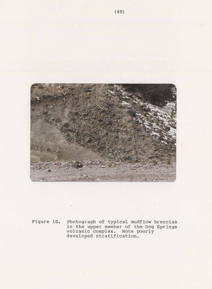
I
Figure 10. Photograph of typical mudflow breccias in the upper member of the Dog Springs volcanic complex. Note poorly developed stratification.
In hand specimen, the pyroxene andesite clasts,
which dominate the upper member mudflow deposits, are
reddish brown when weathered and dark-green when fresh.
Dark-green to black phenocrysts of blocky pyroxene and
elongate hornblende dominate the rock in hand specimen.
Plagioclase phenocrysts are translucent and best viewed
on a cut surface. Phenocrysts are surrounded by a
dense, dark-green, aphanitic groundmass.
Texturally, the pyroxene andesites are
porphyritic, seriate, and trachytic. Phenocrysts make
up 24 percent of the rock by volume and, in decreasing
order of abundance, consist of plagioclase,
clinopyroxene, magnetite, and hornblende. Aphanitic
groundmass consists of plagioclase laths, chlorite, and
clinopyroxene.
Euhedral to subhedral plagioclase is by far the
most common phenocryst and makes up approximately 17
percent of the rock by volume. Plagioclase is also the
dominant mineral in the groundmass. Phenocrysts of
plagioclase display normal and oscillatory zoning,
pericline, carlsbad and albite twins, and occur as
single or composite grains. Phenocrysts of plagioclase
are 2.5 mm in maximum dimension and occur as elongate
and equant crystals. Plagioclase phenocrysts have
s h a r p or corroded margins and commonly e x h i b i t cores
which have been altered t o p h y l l o s i l i c a t e m i n e r a l s .
Euhedra l inc lus ions of a p a t i t e h a v e random o r i e n t a t i o n s
and also are o r i en ted w i th t he i r l ong d imens ions
p a r a l l e l to c l eavage . Anor th i t e con ten t of p l a g i o c l a s e
phenocrys ts was determined using the Michel-Levy
s ta t i s t ica l method which y i e l d e d a va lue of An47
(andes ine) . Approximately 1 2 p e r c e n t of t h e rock by volume is
ch lor i te which occurs as a l t e r a t i o n p r o d u c t s of
groundmass and phenocrysts. Dark-green chlorite occurs
p r i m a r i l y a s a n h e d r a l t o s u b h e d r a l p l a t e s which have
r ep laced maf i c phenoc rys t s . Ch lo r i t e also occurs as
i n t e r s t i t i a l groundmass and f ibrous aggregates in t h e
groundmass. Pale-yellow phenocrysts of clinopyroxene
account for 5 p e r c e n t of the rock volume. Subhedral,
equant phenocrys ts of c l inopyroxene a re 2.0 mm i n
maximum dimens ion , pervas ive ly f rac tured , and commonly
have their c o r e s removed. Opaque minera ls , p robably
magnet i te , account for 2 p e r c e n t of the rock by volume.
Subhedral phenocrysts of hornblende, 1 . 0 mm i n maximum
dimension, account for 1 p e r c e n t of t h e rock by volume.
Hornblende phenocrysts are p l eochro ic and d i s p l a y
colors ranging from pale yellow to r edd i sh brown.
Hornblende phenocrysts have corroded margins which are
commonly mantled by opaque minerals.
The mudflow deposits can be distinguished from the
lower member tuff breccias by several characteristics.
The major distinguishing feature of the mudflow
deposits is the dominance of the pyroxene andesite
clasts over all other clast types. These clasts are
darker in color and denser than the clasts which
characterize the lower member tuff breccias and are
definitely not tuffaceous. The mudflow deposits also
form low hills and poorly exposed, unstratified or
poorly stratified, outcrops as opposed to the steeper
hills and better outcrops formed by the lower member
tuff breccias.
monolithic breccias
Monolithic hornblende andesite breccias occur as
extrusive and intrusive rocks within the upper member.
Generally the extrusive rocks are found above the
lacustrine rocks of Middle Canyon and the intrusive
breccias are found throughout the Dog Springs volcanic
complex. The monolithic hornblende andesite breccias
are correlative to the rhyodacite intrusive and
extrusive rocks of Harrison (1980). These breccias are
locally derived from vents within and directly to the
west of the study area. Possible source areas occur
along the northern and eastern margins of the study
area (Secs.26, 27 and 28, T.2N., R.8W.). These source
areas are characterized by abnormally thick
accumulations of breccia, tens to hundreds of meters
thick, which appears to display cross cutting
relationships with the surrounding rocks. Intrusions
are also locally vesiculated, sheet jointed and have a
prefered alignment of elongate phenocrysts with respect
to the margins of the intrusive body. Harrison (1980)
defined a north-trending vent zone to the west of the
study area. Further evidence for a local source is
provided by the numerous monolithic hornblende andesite
dikes that intruded the lower member of the Dog Springs
volcanic complex. The monolithic nature of these
breccias would not be preserved if if they where
transported long distances as flows.
Outcrops of the breccia are generally massive
(fig.ll), but occasionally contain horizontal
stratification (flows) (fig.12) , and steep cross-cutting relationships (dikes)(fig.13).
Outcrops occur on hillsides and along recently eroded
stream drainages and consist of subangular to angular
clasts which range in size from a few millimeters to
several meters in maximum dimension. Very little
matrix is present in these hornblende andesite
breccias . In hand specimen, hornblende andesites of the
upper member range in color from brownish red when
weathered to a dark olive green when fresh.
Phenocrysts of dark-green to black hornblende and
translucent green plagioclase are visible in hand
specimen. Phenocrysts are set in a dark-green
aphanitic groundmass.
Petrographically, the hornblende andesite clasts
are porphyritic and pilotaxitic. Phenocrysts, in
decreasing order of abundance, are plagioclase,
hornblende, clinopyroxene and magnetite. Phenocrysts
are generally randomly oriented but some are aligned in
a subparallel manner. Groundmass consists of a felted
mass of plagioclase microlites which wrap around the
phenocrysts and a subordinate portion of anhedral
opaque blebs. Phenocrysts account for approximately 40
percent of the rock by volume (fig.14).
Plagioclase is by far the most common phenocryst
and accounts for about 20 percent of the rock by
volume. Euhedral to subhedral laths of plagioclase,
2.5 mm in maximum dimension, show normal and
F i g u r e 11. Photograph of a mass ive ou tcrop of au tob recc ia t ed mono l i th i c ho rnb lende a n d e s i t e i n the upper member of t h e Dog Springs volcanic complex. Note
and lack of s i g n i f i c a n t m a t r i x . u n s o r t e d n a t u r e , a n g u l a r i t y of c l a s t s

F i g u r e 1 2 . Photograph of monol i th ic hornblende andes i t e b recc i a f l ow in t he uppe r member of t h e Dog S p r i n g s v o l c a n i c complex.

Figure 13. Photograph of monol i th ic hornblende a n d e s i t e b r e c c i a d i k e i n t h e Dog S p r i n g s v o l c a n i c comp1.e~.
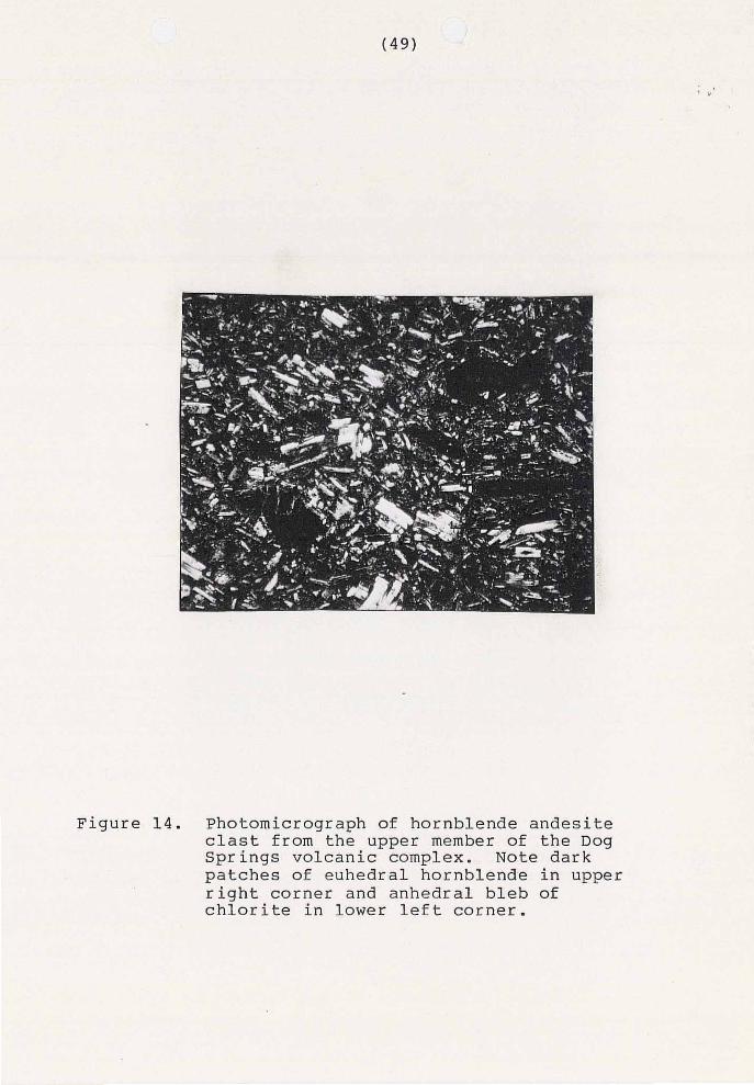
Figure 14. Photomicrograph of hornblende andesite clast from the upper member of the Dog Springs volcanic complex. Note dark patches of euhedral hornblende in upper right corner and anhedral bleb of chlorite in lower left corner.
oscillatory zoning. Plagioclase exhibits albite,
carlsbad and pericline twinning. Margins are usually
sharp but occasionally embayed or corroded.
Plagioclase occurs as single and composite phenocrysts.
Anorthite content was determined using the Michel-Levy
statistical method which yielded a value of An 40
(andesine) . Hornblende accounts for approximately 11 percent
of the rock by volume. Subhedral phenocrysts of
hornblende are commonly mantled by a thick rind of
magnetite and often contain inclusions of plagioclase.
Hornblende phenocrysts may be twinned and exhibit
pleochroic colors ranging from light yellow to reddish
brown. Fracturing and zoning is also present in some
hornblende phenocrysts.
Euhedral to subhedral phenocrysts of clinopyroxene
account for 7 percent of the rock by volume.
Clinopyroxene phenocrysts are 2.0 mm in maximum
dimension and commonly occur in aggregates with
plagioclase crystals. Clinopyroxene crystals have
sharp margins and are often fractured. Clinopyroxene
phenocrysts are rarely twinned and commonly have
inclusions of magnetite and plagioclase. Two percent
of the rock volume consists of anhedral to euhedral
phenocrysts of magnetite, 0.3 mm in maximum dimension.
Chlorite occasionally has replaced mafic phenocrysts
and groundmass.
Several criteria serve to distinguish hornblende
andesite breccias from the underlying lower member
breccias. Characteristically, the hornblende andesite
breccias consist of dark, dense clasts that are not
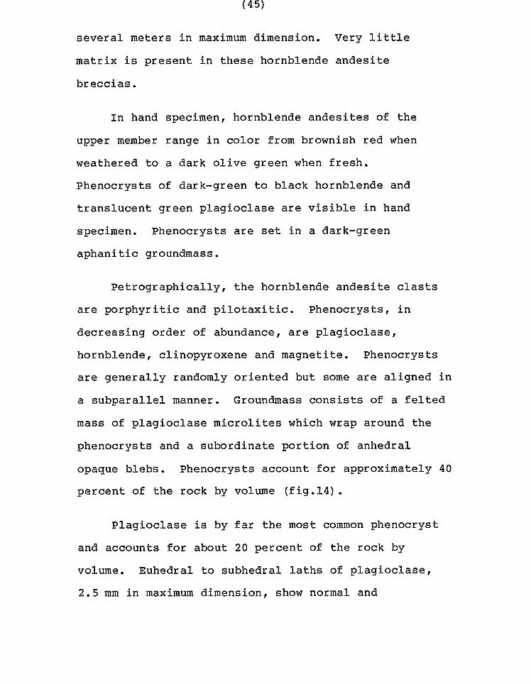
tuffaceous. Another distinguishing characteristic is
the general lack of significant amounts of matrix.
Massive outcrops ,which rarely show any stratification,
and the generally angular clasts also help to
distinguish these hornblende andesite breccias.
Lacustrine Rocks of Middle Canyon
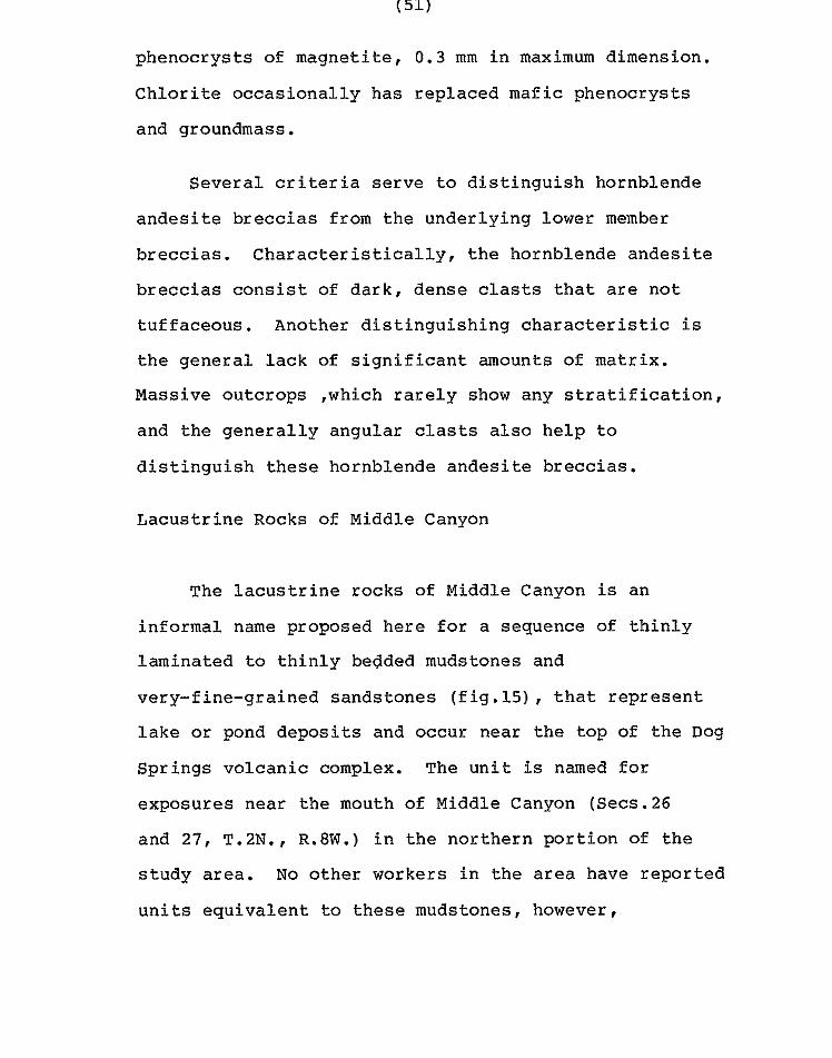
The lacustrine rocks of Middle Canyon is an
informal name proposed here for a sequence of thinly
laminated to thinly bedded mudstones and
very-fine-grained sandstones (fig.15), that represent
lake or pond deposits and occur near the top of the Dog
Springs volcanic complex. The unit is named for
exposures near the mouth of Middle Canyon (Secs.26
and 21, T.2N., R.8W.) in the northern portion of the
study area. No other workers in the area have reported
units equivalent to these mudstones, however,
. .
Figure 15. Photograph of t y p i c a l o u t c r o p of t h e l a c u s t r i n e r o c k s of Middle Canyon.
reconnaissance t o t h e west of the s t u d y a r e a , i n t h e
r eg ion mapped by Har r i son (1980), d id r e v e a l a t least
one outcrop of similar rocks. S imi l a r rocks have a l so
been observed to t h e e a s t of the s tudy area i n Long
Canyon.
The l a c u s t r i n e rocks of Middle Canyon have been
mapped a s a s e p a r a t e u n i t i n t h e s t u d y a r e a whenever
s u f f i c i e n t o u t c r o p is p resen t . The u n i t forms a
d i s c o n t i n u o u s o u t c r o p p a t t e r n across t h e n o r t h e r n
p o r t i o n of t h e s t u d y area n o r t h of t h e Chavez
Well-Thompson Canyon f a u l t and occurs as i s o l a t e d
ou tc rops across t h e n o r t h - c e n t r a l p o r t i o n of t h e s t u d y
a r e a s o u t h of t h e Chavez Well-Thompson Canyon f a u l t .
D e s p i t e t h e p o o r o u t c r o p c h a r a c t e r i s t i c s , t h e u n i t is
t h e on ly good s t r a t ig raph ic marke r i n t h e upper member
of the Dog Spr ings vo lcan ic complex. The u n i t c o v e r s a
t o t a l of about 1.3 square kilometers of the s t u d y a r e a
and forms low h i l l s with col luvium covered s lopes. The
u n i t is only exposed where r ecen t e ros ion has been
a c t i v e . I t is t h o u g h t t h a t the u n i t may be n e a r l y
cont inuous from Chavez Canyon through Middle Canyon to
Old Canyon, and t h a t t h i s l a r g e a r e a of exposure may
r e p r e s e n t t h e d e p o s i t s of a l a r g e l a k e or a series of
small ponds a t about t h e same s t r a t i g r a p h i c i n t e r v a l .
I so l a t ed ou tc rops , such as those south of the Chavez
Well-Thompson Canyon fault, are thought to represent
small ponds formed in drainages disrupted by mudflows.
The lacustrine rocks of Middle Canyon conformably
underlie the monolithic andesite breccias and mudflow
deposits characteristic of the upper portion of the Dog
Springs volcanic complex. Nowhere in the area is the
basal contact of the unit clearly exposed, but it is
thought that the unit lies conformably above, or in
slight local unconformity with, the upper member
mudflow deposits.
In hand specimen, the unit varies from pinkish tan ._
or reddish brown when fresh to light gray when
weathered. In outcrop the unit is pervasively
fractured and often has calcite veins. Calcite veins
as much as 10 cm in width are especially abundant near
the intersection of Chavez and Middle Canyon.
Manganese dendrites are also commonly developed along
fractures and bedding planes. Small plates of biotite
and muscovite are visible with the aid of the hand lens
but account for only a minor portion of the rock
volume. The majority of the rock volume consists of
smectitic clays that quickly absorb moisture. In
outcrop, the unit is usually damp within a meter of the
surface.

Petrographically, the lacustrine rocks of Middle
Canyon are a mass of tiny, low-birefringent and opaque
minerals set in a reddish-brown matrix. The only
identifiable minerals are biotite and plagioclase.
Subangular grains of plagioclase are more common than
biotite and usually exhibit some sort of phyllosilicate
alteration. Plagioclase may also display normal zoning
and albite twinning. Elongate subangular grains of
biotite are pleochroic and range in color from pale
yellow to reddish brown. Elongate grains in the unit
are oriented with their long directions roughly
parallel to bedding.
A single outcrop of similar looking mudstones has
been observed in the lower member of the Dog springs
volcanic complex. The outcrop is located in Old Canyon
about 1.6 kilometers south of the Chavez Well-Thompson
Canyon fault and suggests that caution must be used
when these rocks are used to determine stratigraphic
position within the Dog Springs volcanic complex.
ash-f low tuffs
A few outcrops of crystal-poor, trachytic, poorly
welded ash-flow tuffs are present in the upper member
of the Dog Springs volcanic complex. These outcrops
are located in the northeast corner of section 3 ,
township 1 north, range 8 west and are volumetrically
insignificant; however, they do represent the only
glassy vesicular material in the complex.
In hand specimen, these ash-flow tuffs are light
gray when fresh and yellow gray when weathered.
Phenocrysts of feldspar and lithic fragments are
visible in hand specimen.
Petrographically, these crystal-poor ash-flow
tuffs are porphyritic and have subhedral phenocrysts of
sanidine that account for about 1 percent of the rock
by volume. Groundmass consists of poorly preserved
glass shards, axiolitic growths, and low-birefringence
cryptocrystalline material. Void space and matrix
material has been partially filled or replaced by
calcite and light-green pleochroic chlorite.
sedimentary rocks
Minor fluviatile volcaniclastic rocks are also
present in in the study area. Sandstones and
conglomerates occur throughout the upper member but are
rarely traceable for more than a few meters along
strike.
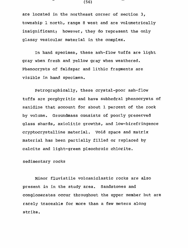
exotic blocks
Exotic blocks consist primarily of Pennsylvanian
to Permian limestones, monolithic, intermediate-
composition breccias of unknown age and, occasionally
reddish-brown sandstones and siltstones of the Permian
Ab0 Formation. Several workers in the northeastern
corner of the Datil-Mogollon volcanic province (Givens,
1957; Lopez, 1975; Harrison, 1980 and Robinson, 1980)
have described such blocks. Harrison mapped limestone
blocks and monolithic tuff blocks several hundred
meters in diameter to the west of the study area and
referred to them as "megabreccia blocks". The term
exotic blocks is used here for these and similar blocks
in the study area because it refers to "rock occurring
in a lithologic association foreign to that in which
the mass was formed" (Bates and Jackson, 1980), and
unlike the term megabreccia has no genetic
significance. In the study area, discordant, rootless
blocks of limestone, intermediate-composition
monolithic volcanic breccias and heterolithic volcanic
breccias are the only mappable exotic blocks present.
Within the region the majority of known exotic blocks
occur in the upper 122 m of the Dog Springs volcanic
complex (fig .16) .

BLOCKS IN THE DOG SPRINGS VOLCANIC COMPLEX.
HARRISON (1980)
W
I- X
LL 0 THIS STUDY
a o 3006 .I- W
I- X
... .. \""",
t 0 5 IO 15 20
, 1 1
NUMBER OF EXOTIC B L O C K S
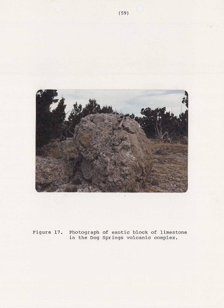
Figure 17. Photograph of exotic block of limestone in the Dog Springs volcanic complex.

Figure 18. Photograph of exotic block of
Dog Springs volcanic complex. crystal-rich, monolithic breccia in the
The limestone blocks are micritic and generally
have fractures filled by blocky spar (Folk, 1974)(fig.
17). Fossils consist of brachiopods, corals, bryozoa
and crinod stems. This fossil assemblage is not
diagnostic of Permian or Pennsylvanian age. Givens
(1956, p.14) indicated that Dr. R.H. Flowers believed
that these limestones were of Permian age. Lopez
(1975) reported that the limestones resembled the
Pennsylvanian Madera Formation and Laroche (1980)
reported a Pennsylvanian fusulinid date from a
limestone block to the east of this study area.
Regardless of age the presence of these light greenish
gray, locally cherty, limestones “quite enigmatic. I5
In the study area, limestone blocks occur
throughout the Dog Springs volcanic complex but are
primarily found in the upper member. The largest
limestone blocks occur in the pyroxene andesite mudflow
deposits of the upper member above the Lacustrine Rocks
.of Middle Canyon.
Dacitic to andesitic, monolithic, crystal-rich,
breccias also occur as exotic blocks in the study area
(f ig.18) . These breccias are similar in appearance
to a quartz latite tuff megabreccia block described by
Harrison (1980) to the west of the study area.
However, the tuff described by Harrison has more
sanidine and quartz than this breccia. No date is
available for the breccia.
These breccias are the most resistant rock type in
the upper member and therefore tend to crop out the
most. Outcrops of the breccia form east-trending
ridges and isolated knobs which are easy to distinguish
from the rest of the upper member. Dike-like blocks of
the breccia are traceable for as much as 0 . 8 km and
vary from a meter to several meters in width. The
east-west trend of the blocks is probably
stratigraphically controlled and may represent a
particularly thick mudflow in the upper member. The
monolithic breccias are sometimes difficult to
recognize within the lower member tuff breccias and
have not always been distinguished from them in the
study area.
Exotic, monolithic breccia blocks are generally
found in a discrete east-trending band approximately
1.6 km wide across the north central portion of the
study area. The breccias cover an area of about 2.6
square kilometers.

Outcrops of the breccias are generally
unstratified and pervasively jointed. Clasts range in
size from a few millimeters to several centimeters, but
rarely exceed a meter in maximum dimension. Clasts are
angular to subrounded and may be either subordinate or
dominant relative to the surrounding matrix. Some
clasts appear to have been stretched suggesting initial
emplacement while still hot enough to be plastically
deformed.
In hand specimen, the breccias are reddish brown
when weatheted and light-gray to reddish gray when
fresh. Clasts are light-gray to greenish gray and are
surrounded by a red or gray matrix. Clasts are
crystal-rich and contain phenocrysts of milky-white
feldspar, black biotite, black hornblende and
occasional quartz. Matrix in these breccias consists
of lithic fragments, crystals, crystal fragments, and
aphanitic material.
Petrographically, the breccias consist of
monolithic, porphyritic clasts of intermediate
composition, set in a light-gray to dull-red matrix.
The matrix consists of low-birefringent
cryptocrystalline material, crystals, lithic fragments,
crystal fragments and opaque material. Matrix is
compositionally similar to the clasts it encloses but
can be distinguished by the lack of igneous textures
and different color (fig.19).
Clasts consist of crudely aligned phenocrysts set
in a groundmass of low-birefringent cryptocrystalline
material and opaque minerals. Phenocrysts, in
decreasing order of abundance, are plagioclase,
hornblende, biotite, sanidine and clinopyroxene.
Phenocrysts account for 30 to 4 5 percent of the rock by
volume.
Plagioclase is always the most abundant phenocryst
present and accounts for 17 to 25 percent of the rock
by volume. Subhedral to euhedral phenocrysts of
plagioclase are 2.0 mm in maximum dimension and have
both sharp and corroded margins. Plagioclase displays
normal and oscillatory zoning, antiperthitic unmixing,
and occurs as single and composite grains. Albite and
carlsbad twinning are common in plagioclase
phenocrysts. Anorthite content was determined for 24
grains (Rittman Zone Method) and yielded an average
value of An 2 4 (oligoclase).
Hornblende content varies from 5 to 2 2 percent of
the rock by volume. Subhedral to euhedral phenocrysts
of hornblende have both sharp and corroded margins and
are often mantled by opaque minerals. Hornblende
phenocrysts occur as single and composite grains, are
2.0 mm in maximum dimension and are occasionally
twinned. Hornblende is pleochroic and ranges in color
from pale yellow to dark reddish brown or green.
Biotite accounts for 1 to 4 percent of the rock by
volume. Biotite has sharp and corroded margins, often
mantled by opaque minerals and occurs as elongate
crystals that may display bent lamella. Biotite is 1.0
mm in maximum dimension and displays pleochroic colors
ranging from golden brown to dark reddish brown.
Opaque minerals, probably magnetite, account for as
much as 5 percent of the rock by volume. Opaque
minerals occur as phenocrysts, groundmass, and mantles
on mafic phenocrysts. Subhedral phenocrysts of
sanidine account for a trace to 1 percent of the rock
by volume and display carlsbad twinning. Clinopyroxene
phenocrysts are present in trace amounts.
These monolithic breccias can be distinguished by
their monolithic nature and massive outcrop
characteristics. In hand specimen, the breccias
crystal-rich character and conspicuous, milky-white
feldspar phenocrysts serve to distinguish it.

Minor outcrops of h e t e r o l i t h i c v o l c a n i c b r e c c i a
s i m i l a r t o lower member tuff breccias , have been
observed i n the upper member. T h e s e h e t e r o l i t h i c t u f f
b recc ia s may r ep resen t exo t i c b locks i n mudflow
depos i t s , pa leo- topographic h ighs or a g rada t iona l
c o n t a c t .
Several hypothesis have been forwarded for the
o r i g i n of t h e s e e x o t i c blocks. Givens (1957) r epor t ed
t h a t t h e b l o c k s were "brought up by the ou tpour ing
t u f f s " . Lopez (1975) obse rved t ha t t h e blocks were
r o o t l e s s , and therefore not basement highs, and t h a t
t hey had d e f i n i t e l y been r a f t e d l a t e r a l l y by l a h a r s .
Harr i son (1980) combined t h e s e two ideas and concluded
tha t t he exo t i c b locks where f l oa t ed upwards and then
r a f t e d l a t e r a l l y by t h e t u f f b r e c c i a s . A c o l l a p s e
o r i g i n , a s w i t h a ca ldera , can be d i s r ega rded a s t he re
are no rocks p re sen t t o act a s a source a rea (Harr i son ,
1 9 8 0 ) . Similar large l imestone blocks have been
r epor t ed i n the Absaroka vo lcanic f ie ld of northwestern
Wyoming. Detachment f a u l t s , s u c h as the Heart Mountain
detachment faul t , have been employed to explain the
e x i s t e n c e of these b locks tha t have t rave led as much a s
50 km from the i r p roposed source a rea (Pierce, 1963) .
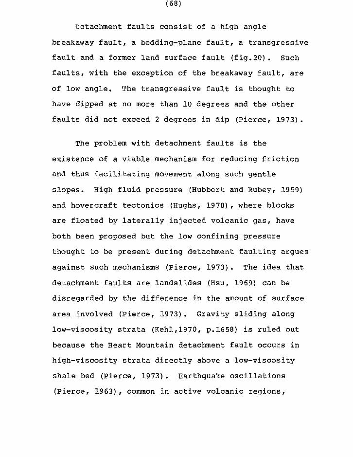
Detachment f a u l t s c o n s i s t of a high angle
breakaway f a u l t , a bedding-plane faul t , a t r a n s g r e s s i v e
f a u l t and a fo rmer l and su r f ace f au l t ( f i g .20 ) . Such
f a u l t s , w i t h the excep t ion of t h e breakaway f a u l t , a r e
of low angle . The t r a n s g r e s s i v e f a u l t is thought t o
have dipped a t no more than 1 0 deg rees and the other
f a u l t s d i d n o t e x c e e d 2 deg rees i n d ip (Pierce, 1973) .
The problem with detachment f a u l t s is t h e
existence of a v i a b l e mechanism for r e d u c i n g f r i c t i o n
a n d t h u s f a c i l i t a t i n g movement a long such gent le
slopes. High f l u i d pressure (Hubbert and Rubey, 1959)
and hove rc ra f t t ec ton ic s (Hughs, 1 9 7 0 ) , where blocks
a r e f l o a t e d by l a t e r a l l y i n j e c t e d v o l c a n i c g a s , h a v e
both been proposed b u t t h e low conf in ing p re s su re
thought to be p resen t du r ing de t achmen t f au l t i ng a rgues
aga ins t such mechanisms (Pierce, 1973) . The i d e a t h a t
d e t a c h m e n t f a u l t s a r e l a n d s l i d e s (Hsu, 1969) can be
d i s r ega rded by t h e d i f f e r e n c e i n t h e amount o f su r f ace
area involved (Pierce, 1973) . Grav i ty s l i d ing a long
l o w - v i s c o s i t y s t r a t a (Keh1,1970, p.1658) is ru l ed ou t
because the Heart Mountain detachment faul t occurs i n
h i g h - v i s c o s i t y s t r a t a d i r e c t l y above a low-viscosi ty
s h a l e bed (Pierce, 1973) . Ea r thquake o sc i l l a t ions
(Pierce, 1963) , common i n a c t i v e v o l c a n i c r e g i o n s ,
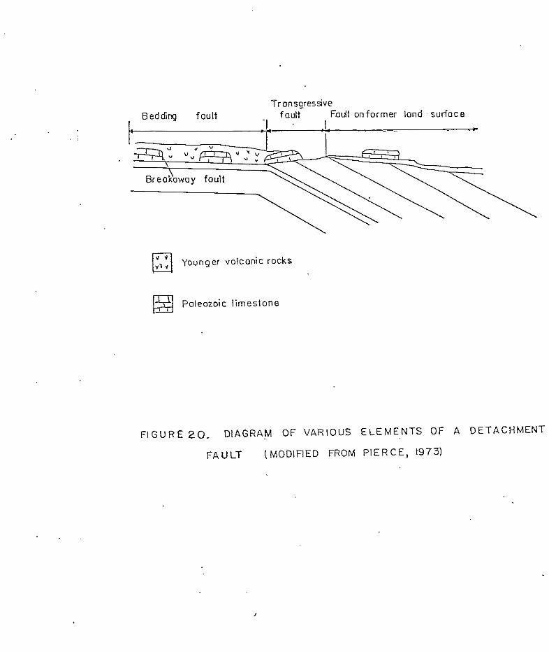
..
f ronsgressve Beddivq foult
;-I- ' :L f oult Fai t onforrner lond 'sur foce . - ..
I -
younger volconic rocks
appear to be the most reasonable mechanism for reducing
friction along detachment faults.
The rootless discordant exotic blocks that occur
throughout the Dog Springs volcanic complex can be
explained by three separate hypotheses or a combination
of three hypotheses. The first hypothesis is that they
were rafted in by mudflows; the second hypothesis is
that they were floated upwards and rafted laterally,
either by tuff breccias or by the hornblende andesite
breccias; and the third hypothesis is that they
represent the transgressive portion of a detachment
fault. Lack of sufficient outcrops makes it impossible
to determine the true origin of these exotic blocks.
Cather (1980) postulated a laramide highland to the
south of the region which could have provided a source
area for the limestone blocks. This, and the presence
of exotic blocks within mudflow deposits suggests that
the exotic blocks were brought in by mudflows from the
south.
cu
Genesis of the Dog Springs volcanic complex
Investigation of the Dog Springs volcanic complex
began when initial reconnaissance of the area indicated
that a thick sequence of relatively undescribed
volcanic rocks was present in the region. This induced
suspicions that an ash-flow tuff caldera, older than
any previously recognized in the region, might exist in
the area. Since work was initiated on the Dog Springs
volcanic complex the following ideas for its’ origin
have been proposed: 1) the Dog Springs volcanic complex
represents the earliest ash-flow tuff caldera in the
region; 2) the Dog Springs volcanic complex represents
a dissected stratovolcano similar to those associated
with the Conejos Formation of the San Juan volcanic
field, and; 3 ) the Dog Springs volcanic complex is an
intermediate-composition volcanic breccia complex
similar to other such complexes located throughout the
western United States.
Harrison (1980) reported similarities and
differences between the Dog Springs volcanic complex
and the current models for ash-flow tuff cauldrons.
Similarities consisted of a discordant fault pattern, a
thick accumulation of fragmental volcanic rocks, and a
central location with respect to a proposed outflow
sheet. Mapping in the study area and reconnaissance to
the north and east of the study area support Harrison’s
observations. However, these observations could also
be explained by the presence of an
intermediate-composition volcanic breccia complex.

Complications with interpreting the Dog Springs
volcanic complex as a caldera include no conclusive
documentation of collapse, very little vesicular
material, and the lack of a well-defined structural or
topographic margin (Harrison, 1980).
Lack of vesicular material in the Dog Springs
volcanic complex seems to indicate that violent
pyroclastic eruptions, which characterize ash-flow tuff
volcanism, did not occur. In the San Juan Mountains of
southwest Colorado sequences of
intermediate-composition volcanic rocks that underlie
the ash-flow tuffs capping the field have been
interpreted as representing stratovolcanos (Lipman and
others, 1972). Similar age and tectonic setting
suggests that the Dog Springs volcanic complex might
have had a similar origin; however, the general lack,
of a well-stratified sequence of interbedded lava
flows, tuffs and breccias argues strongly against the
stratovolcano model (Harrison, 1980).
Numerous intermediate-composition volcanic breccia
fields of much larger volume, but similar to the Dog
Springs volcanic compl.ex, are scattered throughout the
western United States. Such fields include the Tuscan
and Mehrten Formations in California, the Absaroka
Supergroup in Wyoming, the basal portion of the
Thirtynine Mile volcanic field in Colorado, and the
Conejos Andesite of the San Juan volcanic field. Such
fields are characterized by a vent facies surrounded by
an alluvial facies (Parsons, 1969) and a complex
transition zone between the two facies. Intermediate
calc-alkaline magmatism characteristic of such
complexes has been attributed to active subduction
(Lipman and others, 1972). Lydon (1969) attributed
emplacement of such breccia complexes to
stratovolcanos, intrusive dike clusters and hidden
sources. Chapin and Wyckoff (1968) have presented a
model for brecciation and fluidization in the vents of
widely scattered, small breccia cones in the Thirtynine
Mile volcanic field. It is thought that the Dog
Springs volcanic complex represents a small portion of
an intermediate composition volcanic breccia field.
The Dog Springs volcanic complex consists
primarily of three, lithologically distinct, breccias.
These breccias are, the monolithic hornblende andesite
breccias, the lower member tuff breccias and the upper
member mudflow deposits. This suggests that several
brecciation processes were active during formation of
the Dog Springs volcanic complex. Numerous methods for
formation of volcanic breccias have been proposed.
Parsons (1969) modified Wright and Bowes (1963)
classification of volcanic breccias and cited various
structural features, fragment characteristics and
groundmass characteristics that may distinguish
genetically different volcanic breccias. The criteria
cited by Parsons have been employed in this report to
try and determine the origin of the volcanic breccias
in the Dog Springs volcanic complex.
The tuff breccias of the lower member are the most
enigmatic of all the breccias in the study area.
Structural features, fragment characteristics and
groundmass characteristics are not indicative of a
single origin. The tuff breccias may represent
alloclastic breccia flows, laharic breccias, debris
that accumulated on the flanks of fragmenting domes, or
a combination of these processes.
Salient features of the tuff breccias, possibly
indicative of their origin, have been summarized below.
1) The tuff breccias are nonsorted, show no
internal stratification and have subangular to angular
clasts as much as several meters in diameter.
2) The tuff breccias occur as flows several meters
to tens of meters thick, which may show steep or
chaotic bedding, and are rarely traceable for more than
a few tens of meters in outcrop.
3) Locally individual flows are separated by an
undulatory surface or a thin sedimentary parting.
4 ) Flows are completely brecciated.
5) The lower-portion of the lower member tuff
breccias is nearly monolithic and consists of the tuff
breccia of Martin Ranch, which is dominated by clasts
of hornblende andesite.
6) The tuff breccia of Martin Ranch has xenoliths
of Precambrian amphibolite, as well as exotic clasts of
Pennsylvanian limestones and Permian sandstones and
siltstones of the Abo Formation.
7) The tuff breccias above the tuff breccia of
Martin Ranch are heterolithic and are dominated by
clasts of biotite and hornblende andesite. These tuff
breccias have exotic clasts of Permian sandstones and
siltstones and Pennsylvanian limestones, but no
xenoliths of Precambrian amphibolite.
8 ) Tuff breccia clasts are non-vesicular and
porphyritic.
9) Groundmass in the tuff breccias is
compositionally similar to the clasts and consists of
lithic fragments, crystal fragments and interstitial
cryptocrystalline material.
10) No glassy or vesicular material is present in
the tuff breccias.
Many of the characteristics of alloclastic breccia
flows, as described by Parsons (1969), are quite
similar to the tuff breccias of the Dog Springs
volcanic complex. These similarities have been
summarized below.
1) Alloclastic breccia flows are unsorted,
unstratified and have subrounded to angular clasts as
much as 6 m in diameter.
2) Alloclastic breccia flows form beds as much as
a hundred meters thick and may have steep initial dips
near their source.
3) Alloclastic breccia flows are completely
brecciated.

4 ) Alloclastic breccias are heterolithic;
however, the main variations may be in texture, color,
weathering characteristics, and type or percentage of
phenocrysts present rather than gross compositional
differences.
5) Clasts are dense and either porphyritic or
aphanitic.
6) Pumice and scoria is usually absent.
7) Groundmass is fragmental material,
compositionally similar to the clasts, and consists of
lithic fragments, crystal fragments and interstitial
microcrystalline material.
Clearly, numerous similarities exist between
alloclastic breccia flows and the tuff breccias of the
Dog Springs volcanic complex. However, two problems do
exist with this interpretation. These problems are,
the lack of a recognizable source area, and the exotic
clast content.
Alloclastic breccias are formed by the subsurface
brecciation of any pre-existing rock by volcanic
processes (Wright and Bowes, 1963). When extruded,
alloclastic breccias form breccia flows that without an
identifiable source area are almost impossible to
dis t inguish f rom some l a h a r i c b r e c c i a s ( P a r s o n s , 1 9 6 9 ) .
F l u i d i z a t i o n of subsur face b recc ias may occur i n ven t s ,
due t o t h e i n f i l t r a t i o n of s tored meteoric water
(Chapin and Wyckoff, 1 9 6 8 ) , r e s u l t i n g i n t he e rup t ion
of a l l o c l a s t i c b r e c c i a s a s h o t l a h a r s . A l l o c l a s t i c
breccia f lows may a l s o become water sa tura ted and
t r anspor t ed a s l aha r s once t hey a r e e rup ted . C lea r ly a
source a rea is needed to de te rmine i f a vo lcan ic
b recc ia is a l l o c l a s t i c or not . Vents consis t of smal l
cone s t ruc tu res , which may l o c a l l y have s t e e p i n i t i a l
d ips , (Parsons , 1969; Chapin and Wyckoff., 1968) and
d i k e s ( D u r r e l l , 1 9 4 4 ) . Although no cone s t r u c t u r e s
have been recognized , s teep in i t ia l d ips a re common i n
t h e t u f f b r e c c i a s . Lopez (1975) and Bornhorst (1976)
have both reported tuff breccia dikes southwest of t h e
s t u d y a r e a . However, r e c o n n a i s s a n c e t o t h e e a s t
revea led an outcrop of t u f f b r e c c i a , w i t h in te rbedded
s e d i m e n t a r y p a r t i n g s , t h a t h a s n e a r v e r t i c a l beds
o v e r l a i n by moderately dipping beds of t u f f b recc i a .
Th i s sugges t s t ha t l a rge - sca l e so f t s ed imen t
deformation occurred during.4the deposit ion of t h e t u f f
b r e c c i a s , and fur thermore ind ica tes tha t such a process
may be r e s p o n s i b l e f o r s t e e p d i p s and d ike- l ike bodies
observed i n t h e tuff breccias . Chamberl in (1981, oral

commun.) has observed similar soft sediment deformation
and "pseudo" dikes to the west.
To understand the importance of exotic clasts when
interpreting the tuff breccias as alloclastic breccia
flows it is helpful to be aware of the numerous methods
proposed for the formation of alloclastic breccias.
Mechanisms of formation include gas explosion (Johnston
and Lowell, 1961), rock burst (Gates, 1959) , rock spalling (Curtis, 1954) , forceful injection of magma into wall rock, and fragmentation and subsequent
mobilization by fluidization (Parsons, 1969). A l l of
these mechanisms, with the exception of rock spalling,
are relatively violent and result in the mixing of
igneous rock, responsible for the brecciation, and wall
rock, presumably the exotic clasts, surrounding it.
The nearly monolithic character of the tuff breccia of
Martin Ranch suggests that a quiet process, as
described by Curtis (1954), coupled with fluidization
in the vent and subsequent eruption, as outlined by
Chapin and Wyckoff (1968), may have been responsible
for the formation of the lower portion of the lower
member tuff breccias. In addition to wall rock
included at the time of brecciation, clasts
characteristic of the overlying rocks, which must be
intruded for breccias to be extruded, should also be
inc luded as exot ic c las t s . Al though there is a t h i c k
s e c t i o n of Mesozoic and Eocene sedimentary rocks
ove r ly ing t he Pa leozo ic s ec t ion i n t h e a rea no e x o t i c
c l a s t s c h a r a c t e r i s t i c of t h i s s e c t i o n have been
observed. T h i s a rgues aga ins t t he t u f f b recc i a s being
a l l o c l a s t i c b r e c c i a f l o w s .
Laha r i c b recc i a s a l so have numerous . c h a r a c t e r i s t i c s , which a r e summarized below following
t h e c r i t e r i a p r e s e n t e d by Parsons (1969), t h a t a r e
s i m i l a r t o t h e l o w e r member t u f f b r e c c i a s .
1) Lahar i c b recc i a s a r e gene ra l ly poor ly so r t ed ,
gene ra l ly l ack i n t e rna l bedd ing and may con ta in l a rge
blocks weighing several tons .
2) Lahar ic b recc ias occur i n beds a s much a s a
hundred meters t h i c k and contain angular to rounded
fragments .
3) Lahar i c b recc i a s may have t h i n sedimentary
p a r t i n g s . 4 ) Fragments a re genera l ly dense and h e t e r o l i t h i c .
5) Groundmass is c o m p o s i t i o n a l l y s i m i l a r t o t h e
l a rge r f r agmen t s , has a c l a s t i c t e x t u r e and c o n s i s t s of
angular to rounded l i t h i c fragments , pr imary mineral
g r a i n s and c l ay .
I t should be no ted t ha t a complete gradat ion
e x i s t s between a l l o c l a s t i c b r e c c i a f l o w s , h o t l a h a r s ,
c o l d l a h a r s , e p i c l a s t i c v o l c a n i c b r e c c i a s and
volcanic las t ic conglomera tes (Parsons , 1 9 6 9 ) . T h i s
coupled w i t h t he f ac t t ha t t he compos i t ion of a l a h a r i c
b recc ia is dependent on t h e m a t e r i a l a v a i l a b l e a t t h e
t ime .of t r a n s p o r t and subsequent depos i t ion , make f o r a
wide v a r i a b i l i t y i n t he cha rac t e r of l a h a r i c b r e c c i a s .
The above c r i t e r i a a r e o n l y g r o s s g e n e r a l i z a t i o n s t h a t
a r e t r u e f o r some, b u t n o t a l l l a h a r i c b r e c c i a s .
I n t e r p r e t i n g t h e t u f f b recc i a s of the lower member
a s l a h a r i c b r e c c i a s is an a t t r a c t i v e i d e a , e s p e c i a l l y
s i n c e l a h a r i c b r e c c i a s may d i s p l a y a wide v a r i e t y of
c h a r a c t e r i s t i c s o t h e r t h a n t h o s e l isted above. However
numerous problems do ex i s t w i th such an i n t e r p r e t a t i o n .
Laha r i c b recc i a s a r e u sua l ly i n t e rbedded w i t h o the r
rock types such as explos ion brecc ias , t u f f s and l ava
flows i n t h e v e n t f a c i e s , and volcanic sands tones ,
cong lomera te s , a i r f a l l t u f f s and /o r l ake beds i n t h e
a l l u v i a l f a c i e s of a v o l c a n i c f i e l d ( P a r s o n s , 1 9 6 9 ) .

Regional reconnaissance has failed to reveal any of
these characteristics in the tuff breccias of the Dog
Springs volcanic complex. Furthermore a suitable
explanation for the existence of exotic clasts observed
throughout the tuff breccias seems to be lacking. That
is to say, if exotic clasts are incorporated into
lahars during their formation and subsequent
transportation it would follow that the supply of
exotic clasts would be either exhausted or covered by
the initial lahars and thus concentrated at the base of
the volcanic pile; however, as stated, this is not
observed. This point could be explained by a source
area in canyons where Permian and Pennsylvanian strata
is slumping off steep canyon walls.
Autoclastic breccias produced by the fragmentation
of domes and spines share many characteristics of the
lower member tuff breccias, especially the tuff breccia
of Martin Ranch. These characteristics, as ciked by
Parsons (1969), are presented below.
1) Deposits are unsorted, usually unbedded, and
thin rapidly away from source areas.
2) Clasts are monolithic, dense, holocrystalline
or glassy, and are quite angular.

3) Groundmass consists of small fragments of
material identical to the material it encloses.
4 ) Glass shards are not present.
This third hypothesis for the origin of the lower
member tuff breccias is an attractive explanation for
the formation of the tuff breccia of Martin Ranch, due
to the almost monolithic character of this tuff
breccia. However, unless mixing of debris shed off
domes of slightly different composition ,perhaps due to
remobilization by lahars, occurred it is hard to
explain the heterolithic nature of the upper tuff
breccias. Numerous other problems also exist with this
interpretation. Precambrian amphibolites occur as
xenoliths in the tuff breccia of Martin Ranch, but not
in the overlying tuff breccias. This suggests that the
magma chamber was rising and is consistent with the
formation of a dome complex. However, the absence of
any xenoliths of the Paleozoic, Mesozoic, or Cenozoic
rocks that occur in the area argues against the magma
chamber rising near to the surface and therefore argues
against the formation of a widespread dome complex.
Furthermore, Harrison (1980) pointed out that to form a
volcanic complex with the volume of the Dog Springs , a large number of domes would be needed. Domes clearly
contemporaneous with formation of the tuff breccias
have not yet been recognized.
It should be stated that none of the models
presented here explain all of the features of the lower
member tuff breccias. It is possible that any number
of variables were present during the formation of the
tuff breccias and that several sets of variables could
result in the observed characteristics of the tuff
breccias. Therefore, without more data, it is
impossible to formulate a single model for the
formation of these breccias.
The monolithic hornblende andesite.breccias and
mudflow deposits that make up the remainder of the
breccias in the Dog Springs volcanic complex are much
simpler to interpret. The monolithic hornblende
andesite breccias are autoclastic breccias and the
mudflow deposits are the result of mudflows.
Autoclastic volcanic breccias, or friction
breccias, form by autobrecciation of dikes, flows,
domes or spines. Autobrecciated flows are monolithic,
and show no sorting or small-scale bedding.
Autobrecciated flows may have a nonbrecciated core and
consist of angular fragments, which may be quite
scoriaceous, in a groundmass of similar composition
(Parsons , 1969) . Autoc las t ic b recc ias which form from
t h e f ragmenta t ion of domes or s p i n e s a r e u n s o r t e d ,
u n s t r a t i f i e d , c o n t a i n no g l a s s s h a r d s , are monol i th ic ,
dense, may be g l a s s y or ho loc rys t a l l i ne , and may
con ta in mic roves i c l e s (Pa r sons , 1969) . The mono l i th i c
b r e c c i a s of t h e upper member are i n t e r p r e t e d as being
au toc l ’ a s t i c vo lcan ic b recc i a s . They are monol i th ic ,
devoid of g l a s s sha rds , dense , angu la r and have a
groundmass of composition similar t o the c l a s t s .
Monolithic upper member vo lcan ic b recc i a s occu r as
d i k e s , flows, exo t i c b locks and p o s s i b l y domes.
The autoclastic v o l c a n i c b r e c c i a s are p r e s e n t as
b o t h i n t r u s i v e and e x t r u s i v e rocks i n t h e s t u d y a r e a
and t he re fo re de f ine a ven t facies. Formation of
autoclastic b r e c c i a s has been a t t r i bu ted t o s e v e r a l
d i f f e r e n t mechanisms. Wright and Bowes (1963)
sugges t ed t ha t such breccias form by explos ive
f ragmenta t ion of semi-solid or sol id l a v a due t o t h e
r e l e a s e of g a s e s c o n t a i n e d i n t h e l a v a , or by f u r t h e r
movement of l a v a a f t e r it has p a r t i a l l y c o n g e a l e d .
C u r t i s (1954) discussed a method by which
m i c r o v e s i c u l a t i o n , d i l a t i o n f o r m i n g low p r e s s u r e a r e a s ,
and subsequent rock s p a l l i n g i n t o v o i d s p a c e s resul ted
i n t h e s u b s u r f a c e f o r m a t i o n of a u t o c l a s t i c v o l c a n i c
breccias. Changes i n slope (Thompson and o thers , 1965)
and flows moving over ice or snow (Fiske and others,
1963) are also thought to result in autoclastic
volcanic breccias. Since underground brecciation is
known to have occurred and since no evidence of
explosive activity is present, a mechanism of formation
similar to that described by Curtis (1954) is
preferred.
The mudflow deposits of the upper member of the
Dog Springs volcanic complex are characterized by crude
graded bedding, sedimentary partings, localization in
troughs, poor sorting, clasts as much as several
hundred meters in diameter, a heterolithic assemblage
of angular to subrounded clasts, clasts in several
different stages of weathering, and a lack of pumice
and vesicular material. These characteristics indicate
that the deposits were water-laid. Furthermore, the
mixture of very large clasts with very small clasts
indicates these deposits are the result of mudflows.
Mudflows occur when volcanic debris become mixed
with sufficient water to flow downslope. Saturation
may be caused by catastrophic release of water from a
crater lake or other impoundment, by'eruption through a
lake, by heavy rainfall, by rapid melting of snow
(Anderson, 1933) or by infiltration of water into a
vent (Chapin and Wyckoff, 1968). Mudflows may also
result from flow breccias or pyroclastic flows
intersecting active drainages.
Volcaniclastic Rocks of Chavez Canyon
The volcaniclastic rocks of Chavez Canyon is an
informal name proposed here for a sequence of
interbedded sandstones and conglomerates of Oligocene
age, derived by the erosion of volcanic terrain, which
occur stratigraphically above the Dog Springs volcanic
complex and below the tuff of Rock House Canyon. The
unit is named for exposures at Chavez Canyon located in
the north central portion of the study area (Secs.27
and 34, T.2N., R.8W.). The unit can be divided into
upper and lower members but due to lack of exposure has
been mapped as a single unit. The upper member is
equivalent to the lower sedimentary unit of Lopez
(1975), and the first volcanic sedimentary unit of
Bornhorst (1976). The lower member is correlative to
the feldspathic sandstone member of Lopez (1975) and
Bornhorst (1976) and the conglomerate and sandstone
member of Bornhorst (1976). Bornhorst (1976)
correlated the the unit to the lower and middle
sedimentary units of Rhodes and Smith (1976) and to
Tdvsl of Stearns (1962). However, Rhodes and Smith

reported only upper and lower sedimentary units so
there seems to be some confusion in Bornhorst’s
statement. Bornhorst postulated that the unit
represents the distal alluvial facies of the
sedimentary rocks described by Rhodes and Smith
southwest of the study area in the Tularosa Mountains.
Paleocurrent data for the lower member indicates a
north to northwest transport direction (fig.22) and
thus could support Bornhorst’s hypothesis. This is not
true for the upper member which exhibits a northwest
transport direction (fig. 23) . The volcaniclastic rocks of Chavez Canyon is an
extensive unit of regional importance. The unit is
well documented as far north as Chavez and Middle
Canyons (Secs.26, 27, and 28, T.2N, R.8W.) and as far
east as Long Canyon (Sec.13, T.lN., R.8W.) (this
report).. Correlation of the unit to the lower
sedimentary unit of Rhodes and Smith as suggested by
Bornhorst (1976) places the western and southern limits
of the unit at Wagon Tongue Mountain (Secs.19, 20 and
21, T.5S., R.16W.). Reconnaissance to the east has
revealed a 152 m thick section of the volcaniclastic
rocks of Chavez Canyon in the central Gallinas
Mountains (Sec.14, T.lN., R.7W.).
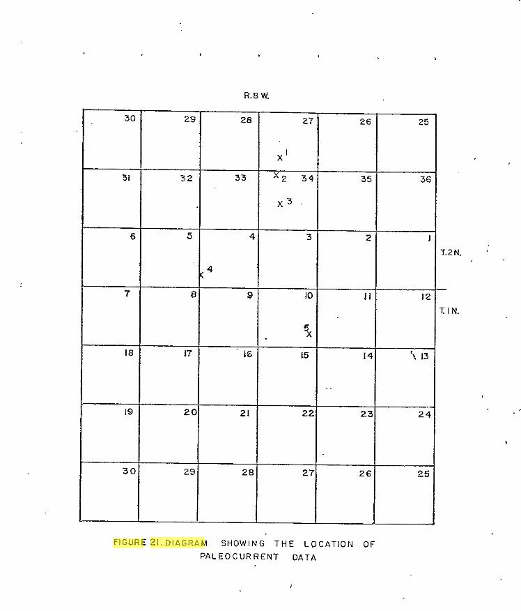
R.8 W.
30
31
6
7
18
19
30
32
5
€
17
2(
28
28
33
4
9
16
21
2E
2i
X '
x 2 31
x 3 '
3
IC
15
2;
2;
26
35
2
I I
14
23
26
25
3f
"
't 13
24
25
T.2N.
i: I N.
flGURE 2 1 . D l A G R A M S H O W I N G T H E L O C A T I O N OF
P A L E O C U R R E N T D A T A
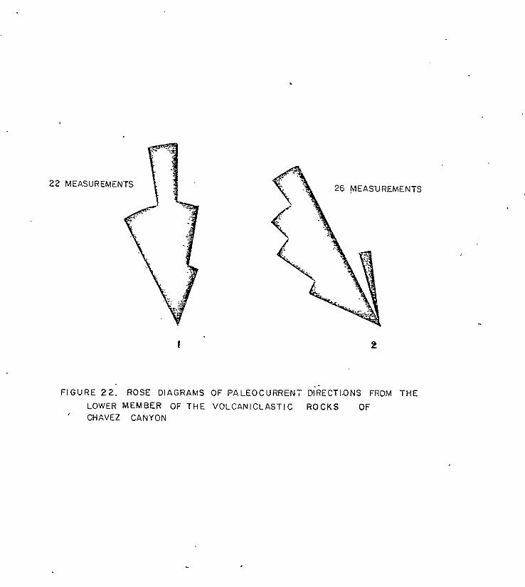
22
FIGURE 22: ROSE DIAGRAMS OF PALEOCURRENT DiRECTI.ONS FROM THE
' CHAVEZ CANYON LOWER MEMBER OF THE VOLCANICLASTIC R O C K S OF
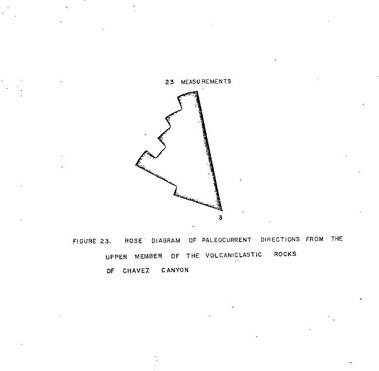
23 MEASUREMENTS
3
,
The volcaniclastic rocks of Chavez Canyon crop out
as steep slopes and as small ledges in canyon floors
throughout the northern portion of the study area.
More commonly, the unit forms steep colluvium covered
slopes on which outcrop is obscured by several meters
of cover. The unit forms two east-trending outcrop
belts across the northern portion of the study area and
covers approximately 7.8 square kilometers of the study
area. The unit varies in thickness from 75 m to 160 m.
The observed variations in thickness are on the up and
down sides, respectively, of the Chavez Well-Thompson
Canyon fault and may date the earliest movement along
the fault.
The volcaniclastic rocks of Chavez Canyon'
unconformably overlie the Dog Springs volcanic complex
(Harrison, 1980). Nowhere in the study area is the
basal contact of the unit exposed; however, attitudes
indicate that the contact is an angular unconformity.
Locally the contact appears to be gradational. The
tuff of Rock House Canyon conformably overlies the
unit.
Lower Member
The lower member of the volcaniclastic rocks of
Chavez Canyon consists of subequal amounts of
sandstones, which display minor shale partings, and
conglomerates (fig.24). Paleocurrent data for the
member indicates a source area to the southeast of the
study area for the lower portion of the member and a
source area to the south for the upper portion of the
member. The lower member varies in thickness between
approximately 4 5 m and 140 m.
Conglomerates vary in color from light gray (N7)
to light brownish gray (5YR 6/1) when fresh to a
moderate yellowish brown or light olive gray ( 5 Y 6/1)
when weathered. Conglomerates are poorly to moderately
sorted and display clast sizes ranging from very fine
sand to boulder-size on the Wentworth Scale. Granule
to boulder-sized clast lithology is. dominated by
subrounded to subangular clasts of andesite accompanied
by a subordinate amount of tuffaceous clasts similar to
the clasts in the underlying tuff breccias and mudflow
deposits of the Dog Springs volcanic complex. Rounded
to subrounded, granule to boulder-sized, tuffaceous
clasts are usually fresh; however, some of the
groundmass in the larger clasts has been altered to a
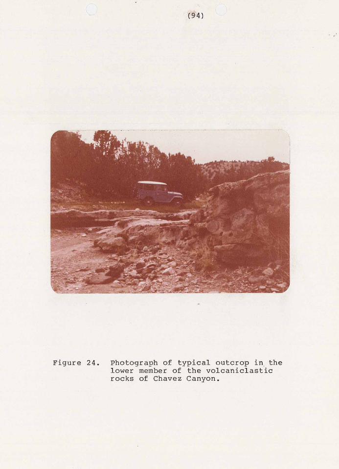
r n '
~~ ".. "... .. .... ~ . ...
Figure 24. Photograph of typical outcrop in, the lower member of the volcaniclastic rocks of Chavez Canyon.
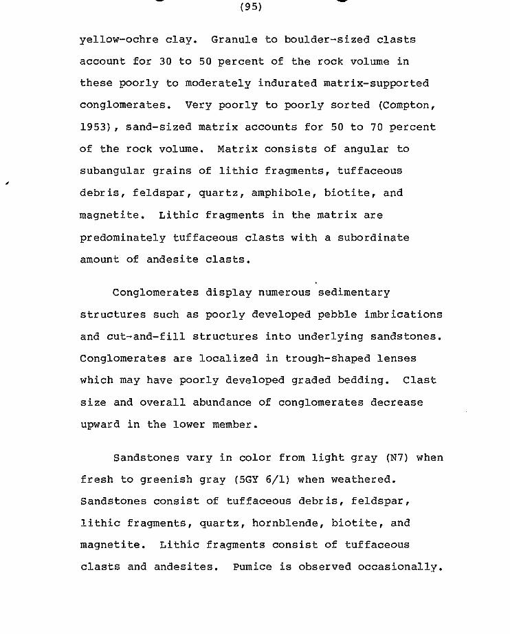
yellow-ochre clay. Granule to boulder-sized clasts
account for 30 to 50 percent of the rock volume in
these poorly to moderately indurated matrix-supported
conglomerates. Very poorly to poorly sorted (Compton,
1953), sand-sized matrix accounts for 50 to 70 percent
of the rock volume. Matrix consists of angular to
subangular grains of lithic fragments, tuffaceous
debris, feldspar, quartz, amphibole, biotite, and
magnetite. Lithic fragments in the matrix are
predominately tuffaceous clasts with a subordinate
amount of andesite clasts.
Conglomerates display numerous sedimentary
structures such as poorly developed pebble imbrications
and cut-and-fill structures into underlying sandstones.
Conglomerates are localized in trough-shaped lenses
which may have poorly developed graded bedding. Clast
size and overall abundance of conglomerates decrease
upward in the lower member.
Sandstones vary in color from light gray (N7) when
fresh to greenish gray (5GY 6/1) when weathered.
Sandstones consist of tuffaceous debris, feldspar,
lithic fragments, quartz, hornblende, biotite, and
magnetite. Lithic fragments consist of tuffaceous
clasts and andesites. Pumice is observed occasionally.
Grains are subrounded to angular and vary in size from
very fine sand to very coarse sand on the Wentworth
Scale. Sorting varies between individual beds from
poor to moderate with finer grained beds displaying a
greater degree of sorting. Flat or elongate minerals
such as biotite and amphibole are commonly arranged
with their long dimension parallel to bedding planes,
and sometimes localized in mafic-rich layers.
Sandstones vary from poor to well-indurated.
Sandstones of the lower member display numerous
sedimentary structures which aided in paleocurrent
determinations. Low angle sets of medium-scale,
tabular-shaped, planar cross-stratification and
wedge-shaped, trough cross-stratification (McKee and
Weir, 1953) are common throughout the central portion
of the member. Flute casts, parting lineations, and
elongate mafic-rich lenses are common along bedding
surfaces. Thickness of individual beds ranges from
thinly cross-laminated to thinly cross-bedded (McKee
and Weir, 1953) and display a direct relationship to
grain size. Graded sandstones occasionally display
thinly laminated shales at their tops. Shales exhibit
ripple marks and mud cracks, which have been preserved
in some cases by infilling with sand.
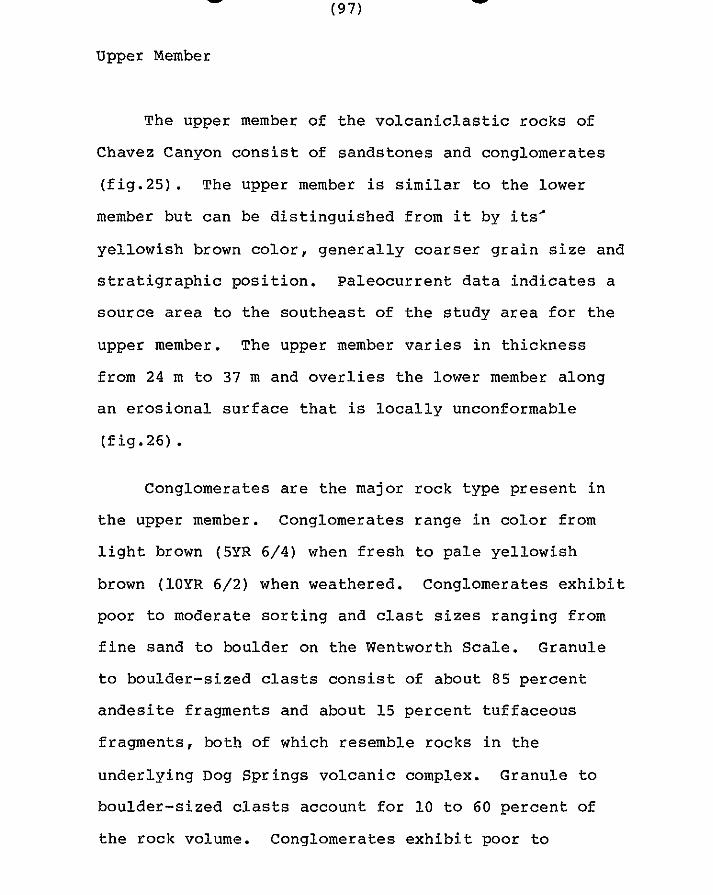
Upper Member
The upper member of the volcaniclastic rocks of
Chavez Canyon consist of sandstones and conglomerates
(fig.25) . The upper member is similar to the lower
member but can be distinguished from it by its’
yellowish brown color, generally coarser grain size and
stratigraphic position. Paleocurrent data indicates a
source area to the southeast of the study area for the
upper member. The upper member varies in thickness
from 24 m to 37 m and overlies the lower member along
an erosional surface that is locally unconformable
(fig.26).
Conglomerates are the major rock type present in
the upper member. Conglomerates range in color from
light brown (5YR 6/4) when fresh to pale yellowish
brown (10YR 6/2) when weathered. Conglomerates exhibit
poor to moderate sorting and clast sizes ranging from
fine sand to boulder on the Wentworth Scale. Granule
to boulder-sized clasts consist of about 85 percent
andesite fragments and about 15 percent tuffaceous
fragments, both of which resemble rocks in the
underlying Dog Springs volcanic complex. Granule to
boulder-sized clasts account for 10 to 60 percent of
the rock volume. Conglomerates exhibit poor to

Figure 25. Photograph of typical outcrop of the upper member of the volcaniclastic rocks of Chavez Canyon.
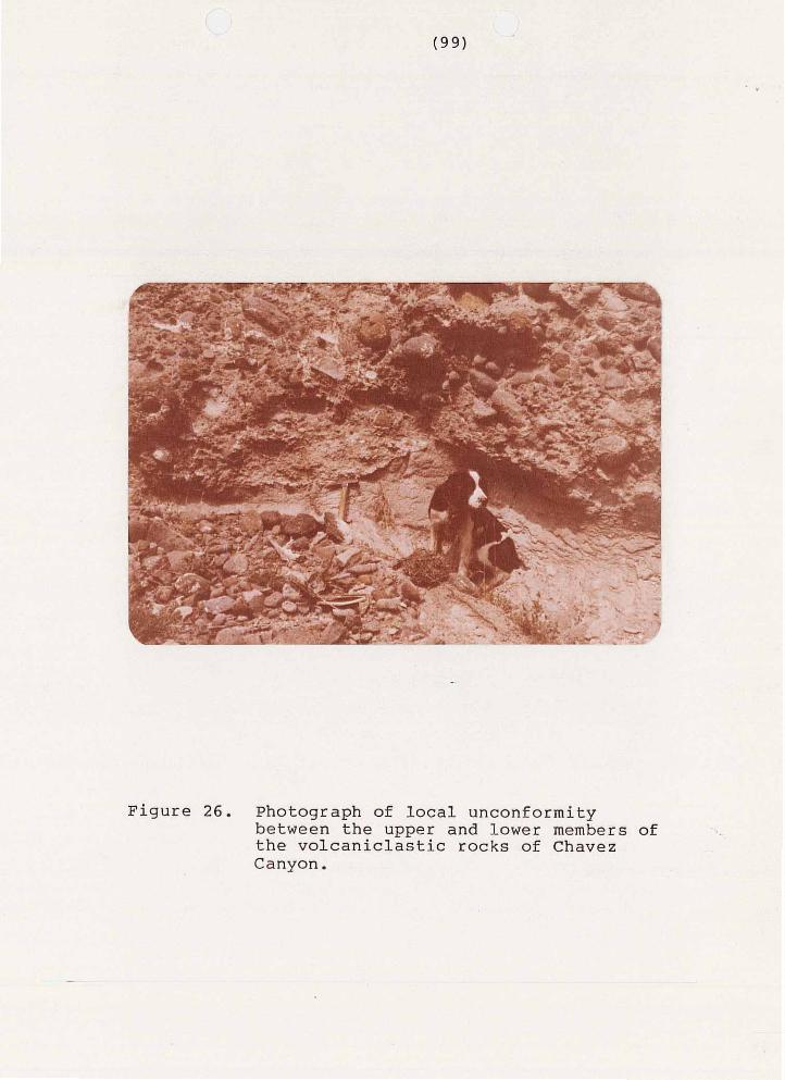
Figure 26. Photograph of local unconformity between the upper and lower members of the volcaniclastic rocks of Chavez Canyon.
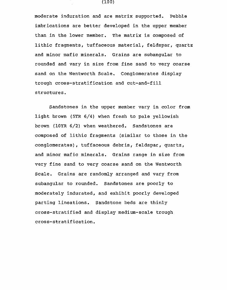
moderate induration and are matrix supported. Pebble
imbrications are better developed in the upper member
than in the lower member. The matrix is composed of
lithic fragments, tuffaceous material, feldspar, quartz
and minor mafic minerals. Grains are subangular to
rounded and vary in size from fine sand to very coarse
sand on the Wentworth Scale. Conglomerates display
trough cross-stratification and cut-and-fill
structures.
Sandstones in the upper member vary in color from
light brown (5YR 6/4) when fresh to pale yellowish
brown (10YR 6/2) when weathered. Sandstones are
composed of lithic fragments (similar to those in the
conglomerates) , tuffaceous debris, feldspar , quartz , and minor mafic minerals. Grains range in size from
very fine sand to very coarse sand on the Wentworth
Scale. Grains are randomly arranged and vary from
subangular to rounded. Sandstones are poorly to
moderately indurated, and exhibit poorly developed
parting lineations. Sandstone beds are thinly
cross-stratified and display medium-scale trough
cross-stratification.

Interpretation
The upper and lower members of the volcaniclastic
rocks of Chavez Canyon share a number of features that
are indicative of their depositional environment. Both
members display an overall fining-upwards sequence and
paleocurrent data indicates that both members were
deposited by low sinuosity streams. Both members
consist of subrounded to angular grains and clasts
which can be interpreted as locally derived first-cycle
sediments. Both members show extreme lateral and
vertical variations in grain size and angularity. Both
members display trough cross-stratification and
cut-and-fill structures. In addition, the lower member
exhibits shale partings, mud cracks, ripple marks, and
increased sorting as grain size decreases. Shelly
(1978, p.41) indicated that low sinuosity is
characteristic of braided streams. Reineck and Singh
(1975) indicated that cut-and-fill structures and
fining-upward trends are characteristic of braided
stream environments. Furthermore Reineck and Singh
indicated that the top of local fining upward sequences
are commonly occupied by horizontal layers of mud or
fine sand, which may exhibit mud cracks, similar to
that observed in the lower member, and that these finer
gra ined sed iments a re less common in mountainous (high
g r a d i e n t ) streams. Matthews (1971, p.140) d i scussed
the extreme v a r i a t i o n i n g r a i n s i z e s p r e s e n t i n b r a i d e d
streams and the l a r g e d e g r e e of local v a r i a b i l i t y i n
g r a i n s i z e d i s t r i b u t i o n e x h i b i t e d by bra ided streams.
Matthews a l s o s t a t e d t h a t medium to f ine-grained sands
commonly e x h i b i t better s o r t i n g t h a n c o a r s e r g r a i n e d
sediments , as observed in t h e lower member. Therefore
i t is conc luded t ha t t he env i ronmen t p re sen t was t h a t
of braided streams of moderate t o steep g r a d i e n t .
t u f f of Rock House Canyon
The tu f f o f Rock House Canyon is a moderately t o
p o o r l y w e l d e d , c r y s t a l - p o o r , l a t i t i c to q u a r t z l a t i t i c ,
ash-f low tuff which separates the upper and lower
p o r t i o n s of t h e Spears Formation. The u n i t was named
by Chapin and others ( in prep) for e x p o s u r e s a t Rock
House Canyon, located i n t h e c e n t r a l p o r t i o n of t h e
s t u d y area (Secs.3, 4 , 1 0 , 11, 1 2 and 13, T . l N . ,
R.8W). The tu f f o f R o c k House Canyon is c o r r e l a t i v e t o
t h e t h e t u f f of Main Canyon (Lopez, 1975; Bornhorst,
1976 and Harr ison, 1980) , the t u f f of Nipple Mountain
(Brown, 1972; Chamberlin, 1974; Wilkinson, 1976; and
Laroche, 1980) and t o Tdhl (Givens, 1957) . Chamberlin
r ede f ined Brown’s tu f f o f Nipple Mountain t o inc lude
" turkey track " andesites commonly found at the base
of the unit. Chamberlin reasoned that the common
association of andesite lava flows at the base of the
unit and the interbedding of andesite lava flows within
the tuff called for such a definition. Wilkinson
reported similar stratigraphic relationships and
adopted Chamberlin's definition. No interbedded
andesites have been observed in the tuff of Rock House
Canyon in the study area. No date or source has been
reported for the unit, however the unit is currently
bracketed between the 37.5 m.y. B.P. date for
volcaniclastic rocks of the Spears Formation and the 33
m.y. B.P. date for the Hells Mesa Tuff. A sample was
collected for K-Ar dating of sanidine, but the results
are not yet available.
The tuff of Rock House Canyon is an extensive
ash-flow sheet which provides the only good
stratigraphic marker between the upper and lower
portions of the Spears Formation. It has been mapped
as far north as Chavez Canyon (Sec.34, T.2N., R.8W.)
(this report), as far south as East Sugarloaf Mountain
(Sec.4, T.2S. , RlOW.) (Bornhorst, 1976) , as far west as Rene Spring (Sec.2, T.2S., R.11W.) (Bornhorst, 1976)
and as far east as Nipple Mountain (Sec.1, T.2S. , R.4W.) (Brown, 1972). Within the study area, the tuff
.

is a multiple-flow simple cooling unit. Chamberlin
(1974) and Wilkinson (1976) reported that the unit was
"a multiple-flow compound cooling unit with
cooling breaks occupied by thin andesitic
to latitic flows." (Wilkinson, 1976, p.28).
The tuff of Rock House Canyon crops out as
pervasively jointed cliffs, isolated outcrops (fig.27)
and south-facing dip slopes throughout the study area.
The unit forms a nearly continuous, 1.2 kilometer wide,
northwest-trending band of outcrops across the central
portion of the study area, and a much narrower,
discontinuous, east-trending band of outcrops across
the northern portion of the study area, where it has
been preserved on the down side of the Chavez
Well-Thompson Canyon fault. The unit covers
approximately 7.8 square kilometers of the study area.
The unit varies in thickness between 50 m and 80 m.
The observed variation can be explained by an
interaction of paleotopography at the time of
deposition and erosion immediately following
deposition. An anomalous thickness of 190 m is present
in the central portion of Rock House Canyon. This can
be explained by a paleovalley or the presence of a
northwest-trending fault with down-to-the-north

F i g u r e 27. Photograph of p e r v a s i v e l y j o i n t e d o u t c r o p of t h e t u f f of Rock House Canyon.
displacement of approximately 60 m, similar to one
thought to cut through the overlying middle
volcaniclastic rocks directly to the south. Reported
thicknesses of 122 m to the east of the study area
(Chamberlin, 1974) and 0 m to the west of the study
area (Bornhorst, 1976) indicate that the unit thickens
to the east and thins to the west.
The tuff of Rock House Canyon overlies, with local
unconformity, sandstones and conglomerates of the upper
member of the volcaniclastic rocks of Chavez Canyon.
This lower contact is exposed on hill 7787 ft (Sec.25,
T.2N., R.8W.). The tuff of Rock House Canyon underlies
the sandstones and conglomerates of the middle
volcaniclastic rocks. The upper contact of the tuff of
Rock House Canyon is not exposed anywhere in the study
area. Harrison (1980) reported that the upper contact
is gradational with the overlying sedimentary rocks.
Poorly welded hand specimens of the tuff of Rock
House Canyon vary in color from light brownish gray
(5YR 6/1) when fresh to light yellowish gray (5Y 8/1)
when weathered. Moderately welded hand specimens vary
in color from medium light gray (N7) when fresh to
light brownish gray (5YR 6/1) when weathered.
Undeformed pumice as much as 3 cm long is common in
poorly welded specimens as is mildly deformed, e longate
pumice i n more densely welded specimens.
I n t h i n s e c t i o n s , t h e tu f f o f Rock House Canyon is
p o r p h y r i t i c and glomeroporphyri t ic . Phenocrysts
account for 3 t o 4 percent of t h e rock volume and vary
i n l e n g t h from 0 . 3 mm to 2 .0 mm. Phenoc rys t s , i n
dec reas ing o rde r of abundance , a re p lag ioc lase ,
s an id ine , magne t i t e , and b io t i te . The groundmass
c o n s i s t s of g l a s s s h a r d s , d e v i t r i f i c a t i o n p r o d u c t s , a n d
f i n e opaque dus t . L i th i c f r agmen t s a r e p re sen t , bu t
gene ra l ly accoun t for less than 1 p e r c e n t of t h e rock
volume.
P l a g i o c l a s e a c c o u n t s for 2 t o 3 percen t o f t he
rock volume and occurs a s s i n g l e and composite grains.
Anhedral t o subhedra l p lag ioc lase phenocrys ts are 1 .3
mm i n maximum l e n g t h and d isp lay sharp , cor roded and
embayed marg ins . P l ag ioc la se exh ib i t s a l b i t e , c a r l s b a d
and per ic l ine twinning . Normal and o s c i l l a t o r y z o n i n g
are bo th p re sen t i n p l ag ioc la se phenoc rys t s .
A n o r t h i t e c o n t e n t was determined for 4 g r a i n s
(Rittman Zone Method) and y ie lded an average anor th i te
c o n t e n t of An20 ( o l i g o c l a s e ) w i t h ve ry l i t t l e d e v i a t i o n
from the mean. Subhedra l t o euhedra l phenoc rys t s of
s a n i d i n e o c c u r a s s i n g l e g r a i n s as much as 2.0 mm i n
length and account for 1 to 2 percent of the rock by
volume. Sanidine displays carlsbad twinning and may
have either sharp, corroded, or embayed margins. Trace
amounts (less than one percent) of anhedral to euhedral
opaque material, thought to be magnetite, display a
cubic form ,and a maximum length of 0.4 mm. Subhedral
laths of biotite are present in trace amounts and
exhibit pleochroic colors ranging from dark brown to
dark reddish-brown.
Groundmass, pumice fragments, and lithic fragments
account for the remaining 97 to 98 percent of the rock
volume. Dark reddish-brown and light-green lithic
fragments are rounded and aphanitic but appear to be of
igneous origin. Pumice fragments have been replaced by
aggregates of low birefringent minerals and may form
axiolitic textures. The remainder of the rock is
composed of mildly deformed or undeformed glass shards,
and opaque dust which imparts a greenish to
yellowish-brown color to the groundmass. Glass shards
are partially devitrified and commonly exhibit
axiolitic textures. Glass shards are deformed around
lithic fragments and phenocrysts. Poorly developed
spherulites are also present. Approximately 1 percent
of the rock volume near the top of the unit is composed
of quartz which occurs as anhedral, monocrystalline and
polycrystalline blebs in the center of glass bubbles.
middle volcaniclastic rocks
The middle volcaniclastic rocks are a sequence of
Oligocene fluviatile sandstones and conglomerates which
occur above the tuff of Rock House Canyon and below the
Hells Mesa Tuff. The unit contains both aeolian and
fluviatile sediments. The unit can be divided into
upper and lower members when the tuff of Blue Canyon is
present; however, in the study area the tuff of Blue
Canyon crops out as a discontinuous belt and therefore
both members have been mapped as a single unit. The
unit is equivalent to Tdh2 and Tdh3 of Givens (1957),
the second and third volcaniclastic sedimentary units
of Bornhorst (1976), the middle and upper
volcaniclastic sedimentary units of Lopez (1975) and
the middle sedimentary unit of Harrison (1980).
Paleocurrent data for the unit indicates a
north-to-northwest transport direction for both members
(fig.28). This does not agree with the observations
of Bornhorst (1976) who reported a southeast transport
direction for the lower portion of the unit near
Sugarloaf Mountain (Sec.21, T.2S., R.11W.) , or with

24 MEASUREMENTS 24 MEASUREMENTS
L
4 5

e data presented by Harrison (1980) which indicated a
northeast transport direction for the unit.
The middle volcaniclastic rocks have been mapped
over a regional extent of approximately 50 kilometers.
The unit crops out as far west as Flying V Draw (Sec.5,
T.2S., R.11W.) (Bornhorst, 1976), as far east as Long
Canyon (Sec.18, T.lN., R.7W.) (this report, and Givens,
1957), as far north as Thompson Canyon (Sec.36, T.2N.
R.9W.) (Harrison, 1980) and as far south as Sugarloaf
Mountain (Bornhorst, 1976). Reconnaissance has
revealed exposures of the unit as far east as the
central Gallinas Mountains (Sec.14, T.lN., R8W.).
The middle volcaniclastic rocks form steep
obsequent slopes and highly dissected south-facing dip
slopes. The unit forms a discontinuous, northwest
trending outcrop belt across the central portion of the
study area and covers approximately 3.9 square
kilometers of the study area. The unit reaches a
maximum thickness of 170 m along the western margin of
the study area and thins eastward to 60 m along the
eastern margin of the study area. Givens (1957) map of
the Dog Springs 15-minute quadrangle shows the unit
pinching out to the east of the study area, however
reconnaissance has revealed that the unit extends
farther east than Givens mapped it. Minor sandstones
and conglomerates have been reported in the same
stratigraphic interval to the east of the study area
(Chamberlin, 1974 and Wilkinson, 1976), however they
are not the dominant lithology. To the west of the
study area, thicknesses between 120 m and 150 m have
been reported (Lopez, ,1975; Bornhorst, 1976 and
Harrison, 1980). An anomalous thickness in excess of
300 m is indicated by cross sections constructed
through the southern portion of Rock House Canyon.
This can be explained by a northwest-trending,
high-angle fault with approximately 120 m.of
down-to-the-north displacement or the presence of a
paleovalley. No definite evidence for either
explanation exists; however, since the unit represents
a constructional depositional sequence the existence of
a fault is favored.
The middle volcaniclastic rocks conformably
overlie the tuff of Rock House Canyon. The unit
unconformably underlies the Hells Mesa Tuff, the
volcaniclastic rocks of South Crosby Peak and the A-L
Peak Tuff. These relationships are due to several deep
paleovalleys formed along an erosional surface present
between the Hells Mesa Tuff and the A-L Peak Tuff. A
more detailed discussion of this surface is presented
in the section on the Hells Mesa Tuff. The erosional
surface has been documented by several studies in the
region (Wilkinson, 1976; Harrison, 1980 and this
report).
Conglomerates are the dominant lithology in the
lower portion of the unit; they become less common,
but are still present, up section. Light-brown to
buff-colored conglomerates exhibit moderate to poor
sorting of clasts ranging in size from boulder to very
fine sand on the Wentworth scale. Granule to
boulder-sized clasts are dominantly andesites with a
subordinate amount of locally derived tuffs. Granule
to boulder-sized clasts were derived from the
interbedded tuff of Blue Canyon, the underlying tuff of
Rock House Canyon and the Dog Springs volcanic complex.
Cobble-sized clasts of limestone have occasionally been
noted towards the base of the unit. Granule to
boulder-sized clasts account for 15 to 50 percent of
the rock by volume in these poorly to moderately
indurated matrix-supported conglomerates. Matrix is
composed of sand and silt-sized tuffaceous debris,
lithic fragments, feldspar, quartz, biotite, and
magnetite. Subangular to subrounded grains of matrix
vary in size from very fine sand to very coarse sand on
the Wentworth scale. Conglomerates have well-developed
pebble imbrications, cut-and-fill structures, trough
and planar cross-stratification, and poorly developed
graded bedding.
Light-brown to buff-colored sandstones range in
size from very coarse sand to very fine sand on the
Wentworth scale and become more common towards the top
of the unit in this fining-upwards sequence.
Sandstones are composed of subrounded to angular grains
of feldspar, quartz, biotite, magnetite,lithic
fragments and interstitial tuffaceous debris.
Tuffaceous debris is especially common directly above
the tuff of Blue Canyon where the unit is composed
almost entirely of reworked detritus from the tuff.
Sandstones are poorly to moderately sorted and range
from poorly to moderately indurated. Flute marks,
cut-and-fill structures, trough and planar
cross-stratification and alignment of elongate minerals
parallel to bedding planes are all present in
sandstones of the unit (fig.29).
Throughout the unit, sandstones and conglomerates
show evidence of a fluviatile origin similar to the
underlying volcaniclastic rocks of Chavez Canyon.
Moreover, with the exception of the presence of lithic
fragments of younger rocks the unit strongly resembles
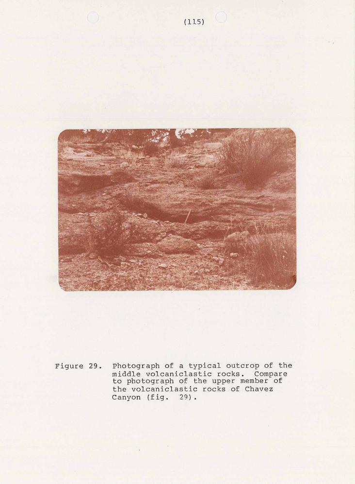
Figure 29. Photograph of a typical outcrop of the middle volcaniclastic rocks. Compare to photograph of the upper member of the volcaniclastic rocks of Chavez Canyon (fig. 29) .
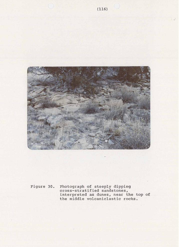
the upper member of the volcaniclastic rocks of Chavez
Canyon, and paleocurrent data indicates a similar
source area. Unlike the underlying volcaniclastic
rocks of Chavez Canyon, the unit occasionally has
steeply dipping cross bedded sandstones near its’ top
that have been interpreted as dunes (fig.30) . Occurrences of similar aeolian sandstones near the top
of the unit are regionally extensive and have been
documented to the west of the study area by Harrison
(1980) and Bornhorst (1976). Therefore it is thought
that the middle volcaniclastic rocks represent a
continuation of the depositional cycle initiated with
the deposition of the upper member of the
volcaniclastic rocks of Chavez Canyon. This cycle
continued until the deposition of the Hells Mesa Tuff,
with only momentary interruptions during the deposition
of the tuff of Rock House Canyon and the tuff of Blue
Canyon. Furthermore it is postulated from the
occurrence of dunes, the style of sedimentation and the
total absence of organic debris that deposition
occurred in an arid to semiarid environment.
Tuff of B l u e Canyon
The t u f f of Blue Canyon is a moderately t o poor ly
we lded , c rys t a l - r i ch , l a t i t i c , a s h - f l o w t u f f i n t h e
upper por t ion o f t he Spea r s Group. The t u f f of B l u e
Canyon was named by Lopez (1975) for exposures a t B l u e
Canyon (Sec.1, T.lS., R. lOW.) , l o c a t e d 1 0 km southwest
of the s t u d y area. The u n i t is e q u i v a l e n t t o the lower
p o r t i o n s of Givens’ (1957) Tdh3, portions of Stearns’
(1962) Tdrp l and Ts t2 of Mayerson (1979. Bikerman
(1976) reported a K-Ar da te o f 32.0 +/- 2 m.y. B.P.
for an ash-f low tuff located i n t h e south Crosby
Mountains (Sec.36, T.4S., R14W.). Bornhorst (1976)
i n d i c a t e d t h a t t h e sample da ted was from t h e
Tuff-Breccia of Horse Spr ings t h a t d i r ec t ly o v e r l i e s
t he t u f f of Blue Canyon a t t h a t l o c a t i o n . No d e f i n i t e
s o u r c e for the un i t has been de t e rmined . Lopez (1975)
p o s t u l a t e d a source for t h e u n i t somewhere t o the
n o r t h e a s t of h i s s t u d y area. However, Bornhorst (1976),
working with an expanded data base, i n d i c a t e d t h a t t h e
s o u r c e of t h e u n i t was to t h e south of h i s s tudy area.
F i e l d mapping of t h e area n o r t h e a s t o f Lopez ( t h i s
report and Harr ison, 1980) has revealed no source for
the un i t : therefore, a source to t h e sou th as
pos tu la ted by Bornhors t is favored by t h i s writer.
The tuff of Blue Canyon,has been mapped as far
east as Jaralosa Canyon (Mayerson, 1979), as far west
as Horse Springs (Bornhorst, 1976) as far north as the
head of Rock House Canyon (this report) and as far
south as Horse Springs (Bornhorst, 1976). A unit
similar to the tuff of Blue Canyon has been reported in
the Joyita Hills by Spradlin (1973) , but has yet to be satisfactorily correlated to the tuff of Blue Canyon.
To the east of the study area, in the same
stratigraphic interval, Chamberlin (1974) and Wilkinson
(1976) have described the tuff of Granite Mountain and
upper Spears crystal-rich latite tuffs, respectively.
These units display higher phenocryst contents and
lower sanidine to plagioclase ratios than the tuff of
Blue Canyon, but are otherwise petrographically
similar. In the study area, the tuff of Blue Canyon is
a simple cooling unit.
The tuff of Blue Canyon crops out as a thin ledge
former when an overlying unit is present and as
south-facing dip slopes when no overlying unit is
present. The unit weathers to rounded, joint-bound
blocks. The unit forms a northwest-trending,
discontinuous, outcrop pattern across the central
portion of the study area and covers about 2.6 square
kilometers of the study area. The discontinuous
outcrop pattern is caused by erosion, alluvial cover
and the localizing of the unit in broad, shallow
paleodepressions at the time of deposition. The unit
varies in thickness from 0 to 10 m and thins eastward.
Reported thicknesses of 24 m (Harrison, oral commun.,
1980) and 46 m (Bornhorst, 1976) indicates that the
unit thickens westward.
The tuff of Blue Canyon overlies with local
unconformity the sandstones and conglomerates of the
middle volcaniclastic rocks (fig.31). This contact
can best be observed near the head of Rock House Canyon
where the tuff of Blue Canyon is localized in a
palaeochannel. The tuff of Blue Canyon conformably
underlies the upper portions of the middle
volcaniclastic rocks.
In hand specimen, the tuff of Blue Canyon varies
in color from pinkish gray (5YR 8/1) when fresh to pale
yellowish brown (10YR 6/2) when weathered. The unit is
usually poorly welded which makes attitude
determinations difficult. Phenocrysts of plagioclase,
sanidine and biotite account for approximately 20
percent of the rock volume. Conspicuous black or
copper-colored hexagonal plates of biotite and the
units characteristic phenocryst content make the tuff

Figure 31. Photograph of t h e b a s a l contact of t h e t u f f of B l u e Canyon.

of Blue Canyon easy to recognize in the field.
Brownish gray (5YR 4/1) subangular to subrounded
aphanitic lithic fragments ranging in size from fine
sand to cobble on the Wentworth Scale account for as
much as 3 percent of the rock volume. Slightly
elongate pumice fragments, cavities formed by pumice
fragments that have subsequently been removed by
weathering, and other cavities, which may be gas
cavities, comprise from 1 to 10 percent of the rock
volume. The cavities and pumice fragments range in
length from 2.0 mm to 25.0 mm and display a long to
short dimension ratio of about 1O:l. Cavities commonly
contain tiny white crystals, possibly quartz and
feldspar, growing inward from their margins. Pumice
fragments are generally smaller than the cavities.
Petrographically, the tuff of Blue Canyon is
porphyritic and possesses, in decreasing order of
abundance, phenocrysts of plagioclase, sanidine,
biotite, clinopyroxene, and hornblende. Phenocrysts
account for 15 to 20 percent of the rock volume and
range in size from 0.3 mm to 4.0 mm in length. The
groundmass consists of mildly deformed glass shards,
glass, poorly developed devitrification products, and
crystal fragments. Lithic fragments are locally
(I,
of Blue Canyon easy to recognize in the field.
Brownish gray (5YR 4/1) subangular to subrounded
aphanitic lithic fragments ranging in size from fine
sand to cobble on the Wentworth Scale account for as
much as 3 percent of the rock volume. Slightly
elongate pumice fragments, cavities formed by pumice
fragments that have subsequently been removed by
abundant and minor amounts of vapor phase minerals are
also present (Table 1).
Subhedral to euhedral laths of plagioclase from
0 . 3 mm to 4.0 mm in length are the most abundant
phenocryst. Plagioclase accounts for 7 to 12.5 percent
of the rock volume. Plagioclase crystals are normally
zoned, commonly with the more calcium-rich cores
removed, and pervasively fractured. Albite and
carlsbad twinning is common, as is rounded corners.
Anorthite content was determined for 22 grains (Rittman
Zone Method) and ranged from An42, for calcium-rich
cores, to An28, for grain margins. An average
anorthite content of An33 indicates that the
plagioclase is andesine. Euhedral crystals of apatite,
oriented both randomly and with their long dimension
oriented parallel to cleavage directions, are common
inclusions in plagioclase phenocrysts.
Subhedral sanidine accounts for 5.5 to 7.5 percent
of the rock volume. Sanidine ranges in length from 0.3
mm to 2.5 mm and commonly exhibits carlsbad twinning.
It occurs as equant and elongate grains wlth rounded
edges and occasional embayments. Subhedral to
euhedral, irregularly embayed, laths of biotite account
for 2 percent of the rock volume. Biotite ranges from
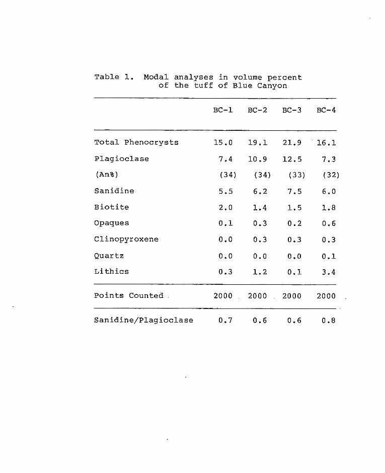
T a b l e 1. Modal a n a l y s e s i n volume p e r c e n t of t h e t u f f of Blue Canyon
BC-1 BC-2 BC-3 BC-4
T o t a l P h e n o c r y s t s
P l a g i o c l a s e
(An%)
S a n i d i n e
B i o t i t e
Opaques
Clinopyroxene
Q u a r t z
L i t h i c s
15 .0 1 9 . 1
7.4 10.9
(34) (34)
5.5 6.2
2.0 1.4
0 .1 0.3
0.0 0.3
0 .0 0.0
0.3 1.2
21.9 16 .1
12.5 7.3
(33) (32)
7.5 6.0
1 .5 1.8
0 .2 0.6
0.3 0.3
0 .0 0 . 1
0 . 1 3.4 ~
Poin t s Coun ted 2000 ~ 2000 2000 2000
Sanidine/Plagioclase 0.7 0.6 0.6 0.8
0.5 mm to 3 . 0 mm in length, is pleochroic and ranges in
color from reddish brown to dark brown. Biotite is
altered to opaque iron oxides around the margins.
Rounded, subhedral to euhedral phenocrysts of
clinopyroxene, probab1.y augite, are present in trace
amounts (less than 1%) and vary in length from 0 . 3 mm
to 1.5 mm. Clinopyroxene sometimes occurs in composite
grains with opaque material and plagioclase.. This
association may indicate that the clinopyroxene is
derived from the lithic fragments. Trace amounts of
pleochroic, subhedral, hornblende phenocrysts ranging
in color from greenish yellow to reddish brown are also
present. Hornblende is 0.5 mm in maximum length and is
altered to iron oxides around the margins. Minor
amounts of low-birefringent minerals, probably quartz
and alkali feldspar line cavities in the upper portion
of the unit and may represent vapor phase minerals.
Groundmass and lithic fragments account for the
remaining 80 to 85 percent of the rock volume. The
brown groundmass is composed of glass, glass shards,
poorly developed low birefringent devitrification
products and crystal fragments. Glass shards are well
preserved and are commonly wrapped around phenocrysts
and lithic fragments. Lithic fragments account for as
much as 3 percent of the rock volume. Lithic fragments
have an aphanitic groundmass of plagioclase, opaque
dust and glass that surrounds phenocrysts of
plagioclase, clinopyroxene, and biotite, or hornblende.
Biotite and hornblende in the lithic fragments have
been completely replaced by magnetite.
Hells Mesa Tuff
The Hells Mesa Tuff is a moderately to densely
welded, crystal-rich, latitic to rhyolitic, ash-flow
tuff. The unit was named by Tonking (1957) for
exposures at Hells Mesa located in the Bear Mountains
(Secs.17 and 20, T.1N. , R. 4W.). The Hells Mesa
Tuff as restricted by Chapin (1974) is equivalent to
the lower, crystal-rich portion of Tonkings’ Hells Mesa
Member of the Datil Formation; it is also equivalent
to Tdh4 and the lower portion of Tdh5 of the Hells Mesa
Member of the Datil Formation as described by Givens
(1957) and to the tuff of Goat Springs (Brown, 1972) . The unit has been dated by several workers. Weber and
Bassett (1963) obtained K-Ar dates of 31.8 m.y. B.P.
and 29.4 m.y. B.P. for biotite near the base of the
unit at the type locality. K-Ar dates of 32.1 and 32.4
m.y. B.P. have been determined for the unit in the
Gallinas Mountains and in the Joyita Hills,
respectively (Burke and others, 1963). Chapin
( u n p u b l i s h e d d a t a ) h a s d a t e d t h e u n i t a t 3 3 m.y. B.P.
The source of the Hells Mesa Tuff is t h e v e r y l a r g e
North Baldy-Socorro Cauldron (Chapin and others, 1978;
E g g l e s t o n , i n prep).
The Hells Mesa Tuff is an extensive ash-flow sheet
of regional importance. I t has been mapped a s far west
a s t h e Dat i l Mountains (Lopez, 1975), as far e a s t as
t h e J o y i t a Hills (Sprad l in , 1971) , as far no r th as
Thompson Canyon i n t h e e a s t e r n D a t i l M o u n t a i n s
(Harr ison, 1980) , and has been r epor t ed a s f a r sou th as
t h e n o r t h e r n p o r t i o n of the Black Range (Els ton , 1975) .
The Hells Mesa Tuff is a mult iple- f low s imple cool ing
u n i t .
The u n i t c r o p s o u t as m a s s i v e c l i f f s when an
o v e r l y i n g u n i t is p r e s e n t and as sou th - fac ing d ip
slopes when no o v e r l y i n g u n i t is p resen t . The u n i t
weathers t o large rounded, joint-bound, blocks or to
p l a ty ou tc rops ( f ig .32 ) . Wi th in t he s tudy a r ea t he
u n i t g e n e r a l l y v a r i e s from 90 m t o 60 m i n t h i c k n e s s
when p resen t . Th i s obse rved va r i a t ion i n t h i ckness is
not sys temat ic th roughout the area, b u t occurs over the
r e l a t i v e l y short d i s t a n c e of 0 . 4 kilometers, and can be
expla ined by one or a combination of t h r e e d i f f e r e n t
factors: 1) underlying paleotopography, 2) i n a c c u r a t e

Figure 32. Photograph of a somewhat platy outcrop of the Hells Mesa T u f f .
location of the basal contact due to poor exposure, and
3) an overlying surface of unconformity. The outflow
facies of the Hells Mesa Tuff thickens to 243 meters to
the east of the study area (Chamberlin, 1974) and thins
to 46 meters to the west of the study area (Lopez,
1975).
The Hells Mesa Tuff is in local unconformity with
concretionary, aeolian and fluviatile sandstones of the
middle volcaniclastic rocks (fig.33). The contact
between the base of the Hells Mesa Tuff and the middle
volcaniclastic rocks is poorly exposed and difficult to
map. To the west of the study area, Harrison (1980) , and Bornhorst (1978) have reported similar contact
relationships; however, to the east of the study area,
the unit overlies the tuff of Granite Mountain
(Chamberlin, 1974) or the tuff of Nipple Mountain
(Laroche, 1980). The basal unwelded zone of the Hells
Mesa Tuff varies from 3 to 9 meters in thickness and
displays an inverse relationship with respect to the
thickness of the unit. This observation is in
agreement with zonal variations in ash-flow tuffs as
described by R.I. Smith (1960) and indicates that a
surface of relatively low relief existed when the Hells
Mesa Tuff was deposited. The A-L Peak Tuff and the
volcaniclastic rocks of South Crosby Peak unconformably

'F igure 3 3 . Photograph of t h e b a s a l non-welded p o r t i o n of t h e Hells Mesa Tuff.

~
I ~
! ! e
(131) e
!
overlie the Hells Mesa Tuff along a regionally
extensive surface of unconformity. This surface of
unconformity is cut by several deep paleovalleys.
Exposures of paleovalleys that have cut completely
through the Hells Mesa Tuff are present on hills 7777
ft (Sec.12, T.lN., R.8W.), and 7770 ft (Sec.12,
T.1N. , R.8W.), and between hills 8221 ft and 8145 ft (Sec.9, T.lN., R.8W.). An exposure of a paleovalley
in which all but a few meters of the Hells Mesa Tuff
has been removed is present on hill 7443 ft (Secs.23
and 24, T.1N. , R.8W.).
In hand specimen, the Hells Mesa Tuff varies from
grayish pink (5R 8/2) when fresh to light brown (5YR
6/4) when weathered. Densely welded hand specimens
vary in color from grayish red (10R 4/2) when fresh to
moderate brown (5YR 4/4) when weathered. Phenocrysts
of sanidine, plagioclase quartz and biotite are visible
in hand specimen. Lithic fragments are locally
abundant and flattened gray pumice is present in the
more densely welded portions of the unit.
In thin section, the Hells Mesa Tuff displays
seriate and porphyritic textures. Phenocrysts account
for 30 to 35 percent of the rock volume and vary in
size from 0.2 mm to 3.0 mm in maximum length.
e (131)
e overlie the Hells Mesa Tuff along a regionally
extensive surface of unconformity. This surface of
unconformity is cut by several deep paleovalleys.
Exposures of paleovalleys that have cut completely
through the Hells Mesa Tuff are present on hills 7777
ft (Sec.12, T.lN., R.8W.), and 7770 ft (Sec.12,
T.1N. , R.8W.), and between hills 8221 ft and 8145 ft
Phenocrys t s i n dec reas ing o rde r of abundance, are
s a n i d i n e , p l a g i o c l a s e , q u a r t z , b i o t i t e , c l i n o p y r o x e n e
and hornblende. The groundmass c o n s i s t s of g l a s s
s h a r d s , d e v i t r i f i c a t i o n p r o d u c t s , f i n e opaque dust and
c rys t a l f r agmen t s (Tab le 2 ) .
Sanid ine is t h e most abundant phenocryst and
accounts for 1 3 t o 14 p e r c e n t of the rock by volume.
San id ine occu r s a s subhedra l t o euhedra l g ra ins ranging
i n s i z e from 3.0 mm t o 0.2 mm i n maximum dimension. I t
commonly exh ib i t s rounded co rne r s and a l t e r a t ion t o
low-birefringence minerals around the margins.
Carlsbad twinning i s p r e s e n t i n some c r y s t a l s and
p e r t h i t i c unmixing is o c c a s i o n a l l y p r e s e n t .
P l a g i o c l a s e o c c u r s as subhedral t o euhedral
phenocrysts and makes up 11 t o 1 2 p e r c e n t of the rock
by volume. P lag ioc lase phenocrys ts commonly have
rounded corners and occasional ly have embayed margins.
P l ag ioc la se phenoc rys t s have a l b i t e , car l sbad , and
p e r i c l i n e t w i n n i n g and have normal or o s c i l l a t o r y
zon ing . Anor th i t e con ten t was determined for 26 g r a i n s
(Rittman Zone Method) and v a r i e d from An21 t o An30 w i t h
an ave rage anor th i t e con ten t of An25 ( o l i g o c l a s e ) . I n
g e n e r a l , a n o r t h i t e c o n t e n t d e c r e a s e s from the base t o
t h e top of the u n i t . Randomly arranged euhedral

T a b l e 2 . M o d a l a n a l y s e s i n v o l u m e p e r c e n t of t h e H e l l s Mesa T u f f
H"1 H " 4
T o t a l P h e n o c r y s t s 3 4 . 2 31.4
S a n i d i n e 1 4 . 0 1 3 .O
P l a g i o c l a s e 11.5 1 2 . 1 (An%) ( 2 2 ) ( 2 5 )
Q u a r t z 6.0 4.0
B i o t i t e 2 . 1 2 . 0
C l i n o p y r o x e n e 0 .4 0.3
Hornblende 0.2 0 . 1
L i t h i c s 0 .8 0 .4
P o i n t s C o u n t e d 2000 2000
Sanidine/p- lagimc-lase ~ .. 1.. 2 1.1
c rys t a l s of a p a t i t e and a p a t i t e c r y s t a l s a r r a n g e d w i t h
t h e i r l o n g d i m e n s i o n p a r a l l e l t o c l e a v a g e a r e common
inc lus ions i n t he p l ag ioc la se phenoc rys t s .
Four t o 6 pe rcen t of t h e rock volume is composed
of anhedra l t o subhedra l qua r t z g ra ins from 4 .0 mm t o
0 .2 mm i n maximum dimension. Margins of quartz grains
a r e rounded and occas iona l ly embayed. Conchoidal
f r a c t u r e s a r e p r e s e n t i n t he ma jo r i ty of g r a i n s a s a r e
s l i g h t l y deformed o p t i c a x i s f i g u r e s which may i n d i c a t e
minor s t r a i n .
Non-opaque maf ic minera ls account for 2 .5 pe rcen t
of the rock volume. Bioti te is the most common mafic
minera l and accounts for 2 pe rcen t of t h e rock volume.
B i o t i t e c r y s t a l s a r e s u b h e d r a l , 2.0 mm i n maximum
dimens ion , and par t ia l ly or c o m p l e t e l y a l t e r e d t o
opaque i ron ox ides . Bio t i te is p leochro ic wi th c o l o r s
ranging f rom yel low to dark reddish brown. Some
b i o t i t e g r a i n s have bent lamellae, possibly due to
compaction. Subhedral grains of hornblende, 2.0 mm i n
maximum dimens ion , a re p resent in t race amounts .
Hornblende exhibits rounded or corroded margins,
p a r t i a l l y removed co res and pleochroism ranging in
co lor f rom greenish ye l low to dark reddish brown.
The remainder of the rock is composed of lithic
fragments, and groundmass. Groundmass is gray to
grayish brown and accounts for 6 5 to 70 percent of the
rock by volume. Groundmass consists of glass, glass
shards, low-birefringence devitrification products,
fine opaque dust and crystal fragments. Poorly
preserved glass shards commonly wrap around phenocrysts
and lithic fragments. Axiolitic textures and
spherulites are present. Spherulites are better
developed in more densely welded portions of the unit.
Rounded lithic fragments, which have a dark aphanitic
groundmass of opaque minerals and glass surrounding
laths of plagioclase, account for about 1 percent of
the rock volume.
Brown (1972) and Chamberlin (1974) reported
vertical compositional variations in the Hells Mesa
Tuff. Brown reported that the ratio of quartz to
feldspar increases from the base to the top of the unit
and that the anorthite content of plagioclase in the
unit also increases slightly up section. Similar data
was generated by this study. Chamberlin reported a
decrease in the anorthite content of plagioclase from
the bottom of the unit to the top of the unit, opposite
of that reported by Brown and this report. From
unpublished data supplied by Deal and Rhodes,
Chamberlin reported an upwards d e c r e a s e i n CaO and a
s l i g h t i n c r e a s e i n Na20. Chamberl in a lso suggested
t h a t an observed decrease i n t h e 2V of sanidine, f rom
t h e b a s e t o t h e top of t h e u n i t , was due t o t h e
v a r i a t i o n i n Na20 content (Troger , 1959) or perhaps due
t o the deg ree of order ing of the A1+3 cations.
V o l c a n i c l a s t i c R o c k s of South Crosby Peak
The v o l c a n i c l a s t i c rocks of South Crosby Peak are
a sequence of interbedded ash-fal l tuffs , ash-f low
t u f f s , t u f f a c e o u s s a n d s t o n e s and conglomerates. The
u n i t was named by T.J . Bornhorst (1976) for exposures
on t h e west side of South Crosby Peak (Secs.25, 26 ,
and 36, T.2S., R.1OW.). The u n i t is equ iva len t t o t h e
t u f f of Crosby Mountain as desc r ibed by Lopez (1975).
B o r n h o r s t p o s t u l a t e d t h a t t h e u n i t represents t h e f i l l
of a poorly documented cauldron, located i n t h e a r e a of
t h e t y p e s e c t i o n and r e f e r r e d t o a s t he Crosby Mountain
dep res s ion . Th i s is n o t t h e case i n t h e s t u d y a r e a
where the un i t does no t exceed 2 1 m i n t h i ckness .
Poorly documented paleocurrent data , f rom pebble
i m b r i c a t i o n s , i n d i c a t e s a no r th -nor theas t t r anspor t
d i r e c t i o n for t h e u n i t i n t h e s t u d y a r e a . T h i s is i n
agreement with a n o r t h e a s t t r a n s p o r t d i r e c t i o n r e p o r t e d
for t h e u n i t by Bornhorst ( 1 9 7 6 ) .

The volcaniclastic rocks of South Crosby Peak are
a volumetrically minor, but regionally extensive unit,
that form a discontinuous outcrop pattern throughout
the region. The unit crops out as far north and east
as Rock House Canyon (Secs.4 and 10, T.lN, R.8W.I
(this report), as far south as Anderson Peak (Sec.6,
T.3S. , R.9W) (Bornhorst, 1976) and as far west as
Sugarloaf Mountain (Sec.21 T.2S. , R.11W.) (Bornhorst,
1976). No units similar to the volcaniclastic rocks of
South Crosby Peak have been recognized to the east of
the study area.
The volcaniclastic rocks of .South Crosby Peak crop
out as steep obsequent slopes, minor ledges and gently
sloping resequent slopes in the study area. The unit
forms a discontinuous outcrop pattern throughout the
south central portion of the study area and covers
approximately 0 . 6 5 square kilometers of the study area.
The discontinuous outcrop pattern of the unit is
attributed to a combination of erosion of the unit and
localization of the unit in paleovalleys. One such
paleovalley is located near the head of Rock House
Canyon where the unit is topographically below the
older Hells Mesa Tuff. The unit varies in thickness
from 0 m to 21 m in the study area and reaches a
maximum recorded thickness of 320 m at the type
locality, located approximately 30 km to the southwest
of the study area (Bornhorst, 1976).
The volcaniclastic rocks of South Crosby Peak -
unconformably overlie the Hells Mesa Tuff and the
middle volcaniclastic rocks. The unit unconformably
overlies the middle volcaniclastic rocks where it has
been localized in a paleovalley approximately 75 m deep
located between hills 8 2 2 1 ft and 8145 ft near the head
of Rock House Canyon (Sec.4 T.lN., Raw,). The unit
conformably underlies and is in local unconformity with
the lower cooling unit of the A-L Peak Tuff.
Within the study area, the unit is predominantly
composed of light-brown to buff-colored conglomerates.
Clast sizes in in these poorly to moderately indurated
matrix-supported conglomerates range from very fine
sand to cobble on the Wentworth scale. Granule to
cobble-sized clasts are dominated by intermediate
composition non-vesicular porphyritic andesites with
subordinate tuff clasts, and account for 10 to 30
percent of the rock by volume. Granule to
boulder-sized tuff clasts are usually derived from the
underlying Hells Mesa Tuff. Very fine grained to
coarse-grained sand-sized matrix in the conglomerates
is composed of tuffaceous debris, quartz, feldspar,
biotite and lithic fragments. Crudely developed pebble
imbrications are the only noticeable sedimentary
structures in these conglomerates.
The remainder of the unit is composed of extremely
tuffaceous sandstones, thought to be reworked ash-fall
or ash-flow tuffs, plus the tuff of South Crosby Peak
and volcaniclastic sandstones. The volcaniclastic
sandstones are poorly to moderately sorted, coarse to
medium-grained, poorly to moderately indurated and
composed of angular to subrounded grains of quartz,
feldspar , biotite, lithic fragments and interstitial tuffaceous debris. The quartz-rich volcaniclastic .
sandstones in the unit are quite similar to the
underlying Hells Mesa Tuff and are thought to be
rewoked detritus derived from it by erosion. The
matrix of the conglomerates probably had a similar
origin.
The tuff of South Crosby Peak is a poorly welded, * crystal-poor, pumice-rich, rhyolitic ash-flow tuff.
The unit was originally named the tuff of Crosby
Mountain by R.C. Rhodes and T.J. Bornhorst (Lopez,
1975) for exposures on Crosby Mountain (Sec.25,
T.2S. , R.1lW.). However, Bornhorst (1976) later
renamed the unit the volcaniclastic rocks of South
Crosby P e a k and i nc luded w i th in t he un i t a l l of the
volcaniclast ic rocks i n t h e s t r a t i g r a p h i c i n t e r v a l
above the tu f f of R o c k Tank and below t h e A-L Peak Tuff
( t h e Hells Mesa Tuff has been cor re la ted t o
Bornhorst 's tuff of Rock Tank by Har r i son (1980) ) .
Harrison (1980) re fe r red t o t h e u n i t as t h e t u f f of
South Crosby Peak and for c l a r i t y t h e same format has
been followed here. That is t h e rocks i n t h e
s t r a t i g r a p h i c i n t e r v a l above t h e Hells Mesa Tuff and
below the A-L Peak Tuff are r e f e r r e d t o as t h e
v o l c a n i c l a s t i c rocks of South Crosby Peak and t h e
a s h - f l o w t u f f i n t e r c a l a t e d w i t h i n t h i s i n t e r v a l is
r e f e r r e d t o as t h e t u f f of South Crosby Peak. The
source of the tuff of South Crosby Peak is thought t o
be a poorly documented cauldron known as the Crosby
Mountain depression (Bornhorst , 1976) located southwest
o f t he s tudy area. No dates are a v a i l a b l e for t h e u n i t
b u t it has been bracketed between dates of
approximately 33 m.y. B.P. f o r t h e u n d e r l y i n g Hells
Mesa Tuff and 30 m.y. B.P. f o r t h e o v e r l y i n g A-L Peak
Tuff . The t u f f of South Crosby Peak c r o p s o u t i n two
l o c a t i o n s w i t h i n t h e s t u d y a r e a . The f i r s t l o c a t i o n is
i n a pa l eova l l ey l oca t ed be tween h i l l s 8145 f t and 8221
f t near the head of 'Rock House Canyon. A t t h i s

F i g u r e 3 4 . Photograph of a t y p i c a l o u t c r o p of t h e tuff of South Crosby Peak. Note l i g h t b l u e l i t h i c f r a g m e n t s of Hells Mesa Tuff .
location, the unit unconformably overlies the upper
portion of the middle volcaniclastic rocks and contains
numerous lithic fragments from the older Hells Mesa
Tuff. Lithic fragments of Hells Mesa Tuff at this
location are as much as 0.5 m in maximum dimension
and are tinted a light blue (fig.34). At this
location, the unit is approximately 15 m below the base
of the Hells Mesa Tuff. The second location where the
tuff crops out is approximately 1.6 kilometers to the
southeast in the saddle between hills 8185 ft and 8241
ft (Sec.9, T.lN., R.8W.). At this location, the tuff
is intercalated within the sandstones and conglomerates
of the volcaniclastic rocks of South Crosby Peak. The
tuff varies from 0 m to 9 m in thickness and commonly
weathers to rounded joint-bound blocks. Within the
study area, the tuff of South Crosby Peak is one of the
least resistive units to weathering.
In hand specimen, the tuff of South Crosby Peak
varies from light tan when fresh to buff when
weathered. The tuff is crystal-poor but does have
phenocrysts of feldspar, biotite and quartz. Lithic
fragments consisting of andesites, unidentified
lower-section tuffs, Hells Mesa Tuff, and pumice
fragments are locally abundant. Lithic fragments vary
in maximum dimension from 1.0 mm to 50 cm with the

l a r g e r clast s izes dominated by t h e Hells Mesa Tuf f .
Pumice fragments are s l i g h t l y e l o n g a t e , r a r e l y e x c e e d
4.0 mm i n l e n g t h and may be imbricated.
P e t r o g r a p h i c a l l y , t h e t u f f of South Crosby Peak is
p o r p h y r i t i c and has , in decreas ing order of abundance,
phenocrys ts of s a n i d i n e , p l a g i o c l a s e , a n d b io t i t e .
Although present in hand specimen, no l i t h i c fragments
or phenocrysts of q u a r t z were obse rved i n t h in s ec t ion .
Phenocrysts account for an es t imated 6 p e r c e n t of t h e
rock by volume and r a n g e i n s i z e from 0 .2 mm t o 4.0 mm
i n maximum dimension. The remaining 94 p e r c e n t of t h e
rock volume is composed of poor ly p re se rved g l a s s
s h a r d s , a n d l o w - b i r e f r i n g e n t d e v i t r i f i c a t i o n p r o d u c t s
which impart a g r e e n i s h t i n t t o t h e rock when viewed
unde r p l ane l i gh t .
Anhedral to subhedra l phenocrys ts o f san id ine
accoun t fo r 4 p e r c e n t of t h e rock by volume. Sanid ine
c r y s t a l s are as much as 2.0 mm i n maximum dimension and
commonly have rounded corners. Sanidine phenocrysts
a r e u s u a l l y f r a c t u r e d and o c c a s i o n a l y d i s p l a y p e r t h i t i c
unmixing. Sanidine crystals are normally zoned and
d isp lay car l sbad twinning . Phenocrys ts of p l a g i o c l a s e
are subhedral t o anhedral and account for 1 p e r c e n t of
t h e rock by volume. P lag ioc la se phenoc rys t s are a s
much a s 4 .0 mm i n maximum dimension, but average about
1 .5 mm i n maximum dimension and have rounded corners.
P l a g i o c l a s e c r y s t a l s a r e n o r m a l l y zoned and twinned
f o l l o w i n g t h e a l b i t e law. An a n o r t h i t e c o n t e n t of An32
(andes ine) was de te rmined for t h e p l a g i o c l a s e u s i n g t h e
Michel-Levy s t a t i s t i ca l method (Heinr ich , 1965) . This
va lue is i n good agreement w i t h data p resen ted by
p rev ious workers (Lopez, 1975; Bornhorst, 1976;
Harrison, 1980) whose a n o r t h i t e v a l u e s c l u s t e r a r o u n d
An30. Bio t i te is p r e s e n t i n trace amounts (less than 1
percen t ) and exh ib i t s pleochroism ranging from dark
r e d d i s h brown t o reddish brown. Bio t i te is subhedra l
and has a maximum dimension of 0 .5 mm.
A-L Peak Tuff
The A-L Peak T u f f , i n t h e s tudy area, c o n s i s t s of
t h r e e p o o r l y t o dense ly welded, c rys t a l -poor ,
r h y o l i t i c , a s h - f l o w t u f f s s e p a r a t e d by an i n t e rva l o f
v o l c a n i c l a s t i c rocks and in te rbedded basa l t ic -andes i te
l a v a flows. Deal (1973) and Deal and Rhodes (1976)
named t h e t u f f s the A-L Peak Rhyo l i t e for exposures in
the San Mateo Mountains. Chapin and others (1978)
referred to t h e u n i t as t h e A-L Peak Tuff . Par ts of
t h e u n i t are c o r r e l a t i v e t o the banded r h y o l i t e of
Loughlin and Koshman (1942) , the upper por t ion of

Tonkings’ (1957) Hells Mesa Member, Givens’ (1957)
Tdh7, Tdh6, and portions of Tdh5, Brown’s (1972) tu f f
of Bear Spr ings , and the t u f f of Wahoo Canyon as
desc r ibed by Fodor (1975). The in te rbedded maf ic flows
are c o r r e l a t i v e t o t h e b a s a l t i c a n d e s i t e of Twin Peaks
as desc r ibed by Lopez (1975) . Wi th in the s tudy a rea ,
four mappable u n i t s a r e present i n t h e A-L Peak Tuff .
The age of t h e A-L Peak Tuff is bracketed between 33
m.y. B.P. f o r t h e u n d e r l y i n g Hells Mesa Tuff ( B u r k e
and others, 1963) and 28 m.y. B.P. f o r t h e o v e r l y i n g
Lemitar Tuff (Chapin, unpublished data). This is i n
good agreement with a d a t e of 28-28.3 m.y. f o r t h e
Anchor Canyon Stock (Weber and Rassett , 1963) which
intrudes the uni t (Chapin, 1971-a) and a d a t e of 30.1
m.y. B.P. f o r t h e i n t e r c a l a t e d b a s a l t i c a n d e s i t e of
Twin Peaks (Chapin, unpubl ished data) .
The A-L Peak Tuff forms an extensive ash-f low
s h e e t t h r o u g h o u t t h e n o r t h e a s t corner of t h e
Datil-Mogollon Volcanic Province. The u n i t ou tc rops a s
f a r east a s t h e J o y i t a Hills (Spradl in , 1973) , as fa r
west as the Crosby Mountains (Bornhorst, 1976) , as f a r
n o r t h a s t h e Bear Mountains (Brown, 1972) and a s f a r
sou th as the San Mateo Mountains (E l s ton , 1975).

The outflow facies of the A-L Peak Tuff has been
divided into upper and lower cooling units by Chapin
and Deal (1976). The lower cooling unit is a
multiple-flow compound cooling unit composed of the
flow-banded and gray-massive members. The upper
cooling unit is a multiple-flow simple cooling unit
consisting of the pinnacles member. The cooling break
between the upper and lower cooling units is commonly
occupied by an interval of basaltic-andesite flows and
volcaniclastic rocks (Chapin and Deal, 1976). Similar
relationships to those described above are present in
the study area.
Lower Cooling Unit
The lower cooling unit of the A-L Peak Tuff in the
study area is a multiple-flow compound cooling unit
consisting of two crystal-poor, moderately to densely
welded, rhyolitic ash-flow tuffs. The two tuffs are
thought to be correlative to the gray-massive and
flow-banded members of the A-L Peak Tuff as described
by Brown (1972). A distinct cooling break in the form
of a reversal in welding can be identified between the
two tuffs. The cooling break is poorly exposed
throughout the study area so the two ash-flow tuffs
have been mapped as a single unit.

The lower c o o l i n g u n i t of t h e A-L Peak Tuff crops
out as modera te t o steep obsequent slopes, poor ly
de f ined l edges and south-facing dip slopes. The u n i t
crops o u t a s a nor th- t rending b e l t along the r i d g e east
of North L a k e Canyon and as a nor thwes t - t rending be l t
a long the r i d g e s o u t h of Rock House Canyon. Isolated
ou tc rops of t h e u n i t are loca ted on h i l l s 7777 f t and
7770 f t a long t he ea s t e rn marg in of t h e s t u d y area
(Secs.12 and 24, T . l N . , R.8W.) where t h e u n i t was
deposited i n p a l e o v a l l e y s . The un i t cove r s abou t 3.9
square kilometers of the s t u d y area. The u n i t
g e n e r a l l y v a r i e s i n t h i c k n e s s from 4 5 m t o 30 m when it
is p r e s e n t and una f fec t ed by sur face e ros ion . Rapid
v a r i a t i o n s i n t h i c k n e s s o c c u r due t o t h e l o c a l i z a t i o n
of t h e u n i t i n p a l e o v a l l e y s .
The lower cool ing un i t unconformably over l ies the
Hells Mesa Tuff and conformably overlies t h e
v o l c a n i c l a s t i c rocks of South Crosby Mountain when they
are p resent . Along t h e eas te rn margin of t h e s tudy
a r e a , t h e u n i t has been deposited i n p a l e o v a l l e y s and
unconfo rmab ly ove r l i e s t he t u f f of Rock House Canyon
and the upper member of t h e Dog Spr ings vo lcan ic
complex. The lower cool ing uni t unconformably
u n d e r l i e s v o l c a n i c l a s t i c rocks and t h e b a s a l t i c
a n d e s i t e of Twin Peaks t h a t occupy t h e coo l ing break

between t h e upper and lower c o o l i n g u n i t s of t h e A-L
Peak Tuff.
I n hand specimen, densely welded samples vary from
gray i sh b l ack (N2) or g r a y i s h r e d ( 5 R 4/2) when f r e s h
to g ray i sh r ed ( 1 0 R 4/2) or brownish gray (5YR 4/1)
when weathered. Moderately welded samples vary in
color from pale red p u r p l e (5- 6/2) or l igh t b rowni sh
g r a y (5YR 6/1) when f r e s h t o p a l e y e l l o w i s h brown (10
YR 6/2) when weathered. Phenocrysts of s a n i d i n e ,
quar tz and b io t i t e as well a s l i t h i c f r a g m e n t s , pumice
f r agmen t s and gas cav i t i e s a r e v i s ib l e i n hand
specimen.
I n t h i n s e c t i o n , t h e lower c o o l i n g u n i t is
p o r p h y r i t i c and has phenocrysts of s a n i d i n e , b i o t i t e ,
plagioclase, c l inopyroxene, opaque minerals and sphene
(Table 3 ) . No q u a r t z was o b s e r v e d i n t h i n s e c t i o n b u t
trace amounts are p r e s e n t i n hand specimen. Groundmass
c o n s i s t s of we l l -deve loped dev i t r i f i ca t ion p roduc t s ,
vapor-phase minerals , g lass and opaque dust . Li thic
f ragments are abundan t and cha rac t e r i s t i c of t h e lower
c o o l i n g u n i t .
Sanid ine is t h e most abundant phenocryst and
accounts for 3 t o 5 p e r c e n t of t h e rock volume.
Phenocrysts of s a n i d i n e a r e s u b h e d r a l to euhedra l , 1 .5
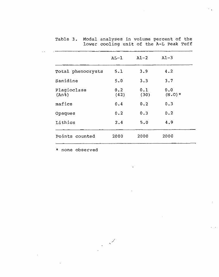
Table 3. Modal analyses in volume percent of the lower cooling unit of the A-L Peak Tuff
AL- 1 A1-2 A1-3
Total phenocrysts 5.1 3.9 4.2
Sanidine 5.0 3.3 3.7
Plagioclase 0.2 0.1 0.0 (An%) (42) (30) (N .0 ) * maf ics 0.4 0.2 0.3
Opaques 0.2 0.3 0.2
Lithics 2.4 5.0 4.9
Points counted 2000 2000 2000
* none observed
i
. .
mm i n maximum l e n g t h and commonly f r a c t u r e d . S a n i d i n e
is normally zoned and exhibi ts car lsbad twinning.
San id ine has e i the r sha rp or corroded margins with
occas iona l embayments. P l a g i o c l a s e , b i o t i t e ,
clinopyroxene, opaques and sphene are a l l present i n
amounts less than 0 . 5 percent . Anhedral to subhedral
pl .agioclase, 0 .5 mm i n maximum l e n g t h , is commonly
fractured, has a lbi te twinning, and corroded margins .
A n o r t h i t e c o n t e n t was determined for 3 gra ins (Ri t tman
Zone Method) which yielded an average anorthi te content
of An36 (andes ine) . Subhedra l t o a n h e d r a l b i o t i t e , 1 .0
mm i n maximum l e n g t h , is p leochro ic w i t h colors ranging
from redd i sh brown to golden brown. Bio t i te e x h i b i t s
b o t h s h a r p and corroded margins. Pale-green, euhedral
t o subhedral c l inopyroxene, 0.7 mm i n maximum l e n g t h ,
i s p resen t bu t may r e p r e s e n t f o r e i g n material de r ived
from l i t h i c fragments . A s i n g l e honey brown,
diamond-shaped c r y s t a l of sphene, 0 .5 mm i n l e n g t h , was
observed. Subhedral t o euhedral opaque cubes, 0 . 5 mm
i n maximum leng th , a r e p robab ly magne t i t e .
Li thic f ragments and groundmass account for the
remaining 95 t o 97 p e r c e n t of t h e rock volume. Very
wel l -deve loped devi t r i f ica t ion products dominate the
groundmass. D e v i t r i f i c a t i o n p r o d u c t s c o n s i s t of low
b i r e f r ingen t mine ra l s , p robab ly tridymite,
c r i s t o b a l i t e , and a l k a l i f e l d s p a r s (Ross and S m i t h ,
1 9 6 1 ) , which a r e p a r t i c u l a r l y well deve loped as p la ty
or r ad ia t ing aggrega te s i n e longa te pumice fragments.
Vapor-phase minerals are present i n l i t h o p h y s a l
c a v i t i e s . S m a l l amounts of g l a s s a r e p r e s e r v e d and
g lass shards can be seen wrapped around phenocrysts and
l i t h i c fragments. Red i ron ox ide d u s t is common
throughout the groundmass and when present impar t s a
red co lor to the rock; o therwise the g roundmass is
l i g h t g r a y . L i t h i c f ragments account for 2 t o 6
pe rcen t of the rock volume. Li thic f ragments are
p o r p h y r i t i c and p i l o t a x i t i c . S u b p a r a l l e l a l i g n m e n t of
c l inopyroxene , p lag ioc lase and opaque phenocrysts in a
groundmass of opaque d u s t and p l a g i o c l a s e m i c r o l i t e s is
c h a r a c t e r i s t i c of t h e l i t h i c fragments .
i n t e rbedded vo lcan ic l a s t i c rocks
The i n t e r v a l between the upper and lower cooling
u n i t s of t h e A-L Peak Tuff is occupied by a sequence of
f l u v i a t i l e v o l c a n i c l a s t i c s a n d s t o n e s and conglomerates
and t h e b a s a l t i c a n d e s i t e of Twin Peaks. The
sedimentary rocks are present throughout the s tudy
a rea . The sedimentary rocks generally form moderately
sloping, colluvium-covered h i l l s capped by t h e upper
coo l ing un i t . The sedimentary rocks form a
discontinuous outcrop pattern that covers approximately
0.78 square kilometers across the central portion of
the study area. The sedimentary rocks rarely crop out,
but good exposures of the unit are present on the hill
south of the saddle marked 7809 ft (Sec.15, T.1N. , R.8W.). Similar sedimentary rocks have been reported
in the same interval on a regional scale by Chapin and
Deal (1976) . The contact of these sedimentary rocks with the
underlying lower cooling unit is an erosional
unconformity along which the portion of the lower
cooling unit above the uppermost densely welded zone
has been removed. This relationship is not present on
the ridge east of North Lake Canyon where the basaltic
andesite of Twin Peaks rests directly on the lower
cooling unit of the A-L Peak Tuff. The contact of the
volcaniclastic rocks with the overlying upper cooling
unit of the A-L Peak Tuff is conformable. Contact
relationships with the intercalated basaltic andesite
of Twin Peaks are generally.conformable but both upper
and lower local unconformities do exist. The
volcaniclastic rocks have been localized in
paleodepressions and vary between 6 m and 25 m in
thickness.

Light-gray t o buff-colored sedimentary rocks which
c h a r a c t e r i z e t h e i n t e r v a l are poor ly i ndura t ed and
commonly pumice-rich. Some of the pumice-r ich lenses
exceed 60 p e r c e n t pumice by volume and e x h i b i t pumice
fragments as much as 1 3 cm i n maximum dimension.
Poor ly so r t ed s ands tones and matrix-supported
conglomerates are composed of pumice, fe ldspar ,
t u f f a c e o u s d e b r i s , q u a r t z and b i o t i t e . Randomly
o r i e n t e d pumice is the main clast t y p e i n the
conglomera tes bu t basa l t ic -andes i te f ragments are also
p r e s e n t . The u n i t d i s p l a y s c u t - a n d - f i l l s t r u c t u r e s ,
r e v e r s e and normal graded bedding, planar paral le l
laminat ions, smal l -scale low-angle planar t rough
c r o s s - s t r a t i f i c a t i o n , a n d b e d d i n g t h i c k n e s s e s r a n g i n g
from th in ly l amina ted t o t h i n l y bedded. Vert ical
v a r i a t i o n s c o n s i s t of a n o v e r a l l i n c r e a s e i n s o r t i n g ,
pumice s i z e and bedding thickness, and a d e c r e a s e i n
t u f f aceous debris from bottom t o top. I t is thought
t h a t t h e u n i t r e p r e s e n t s reworked a s h - f a l l t u f f s and
pumice flows which occurred prior t o t h e e r u p t i o n of
t h e upper cool ing un i t of t h e A-L Peak Tuff .
basaltic andesite of Twin Peaks
The basaltic andesite of Twin Peaks is composed of
basaltic-andesite lava flows which have vesicular tops
and dense cores. The unit was named by Lopez (1975)
for exposures at Twin Peaks, located in the Datil
Mountains (Secs.18 and 19, T.2S., R.9W.). The basaltic
andesite of Twin Peaks is equivalent to portions of
Tdh6 as described by Givens (1957). To the east of the
study area, Chamberlin (1974) , Wilkinson (1976) , Simon (1973) and Spradlin (1973) have all reported
basaltic-andesites in the same interval and, to the
west of the study area, Bornhorst (1976) reported a
basaltic-andesite directly above the lower cooling unit
of the A-L Peak Tuff. It appears that the basaltic
andesite of Twin Peaks represents the first mafic
igneous activity in the study area associated with the
onset of bimodal volcanism which now characterizes much
of central New Mexico. The unit was sampled for I<-Ar
dating (this report and Harrison, 1980) which yielded a
date of 30.1m.y. B.P. (Chapin, unpublished data).
No source for the unit was found in the study area.
The basaltic andesite of Twin Peaks is located in
a stratigraphic interval occupied by basaltic-andesites
on a regional scale. Stratigraphically equivalent

u n i t s have been repor ted as fa r east a s t h e J o y i t a
Hills (Sprad l in , 1973) , as f a r west as the Crosby
Mountains (Bornhorst, 1976) , a s f a r n o r t h as t h e
Gal l inas Mounta ins ( th i s repor t ) and as fa r sou th as
the Crosby Mountains (Bornhorst , 1976) .
The b a s a l t i c a n d e s i t e o f Twin Peaks c rops o u t as
t h i n l e d g e s and south-facing dip slopes, when p r e s e n t .
The un i t wea the r s t o form a dark-brown soil and blocky
t a l u s slopes which cover the under ly ing u n i t s . Th i s
c h a r a c t e r i s t i c is p a r t i c u l a r l y e v i d e n t when viewing
ae r i a l pho tographs . The u n i t v a r i e s i n thickness f rom
0 m to 25 m. The o b s e r v e d v a r i a t i o n s i n t h i c k n e s s c a n
be explained by t h e l o c a l i z a t i o n of t h e u n i t i n
pa l eochanne l s . Th i s l oca l i za t ion can be observed a t
t h e b a s e of t h e h i l l j u s t s o u t h of t h e s a d d l e marked
7809 f t (Sec.15, T . lN . , R.'8W.) and on the r idge eas t of
North Lake Canyon ( f ig .35 ) . The u n i t is a b s e n t on
h i l l 7545 f t (Sec.23, T . lN . , R.8W.) and on t h e eastern
slope of t h e h i l l d i r e c t l y s o u t h of t h e s a d d l e marked
7809 f t (Sec.15, T . l N . , R.8W.). The u n i t c o v e r s
approximately 0 .65 square kilometers of the s tudy a rea .
The b a s a l t i c a n d e s i t e of Twin Peaks is i n local
unconformi ty wi th under ly ing vo lcanic las t ic rocks when
t h e y are p r e s e n t , o t h e r w i s e t h e u n i t unconformably
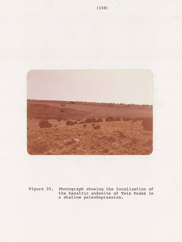
Figure,35. Photograph showing the localization of
a shallow paleodepression. the basaltic andesite of Twin Peaks in

o v e r l i e s t h e lower c o o l i n g u n i t of t h e A-L Peak Tuf f .
The u n i t g e n e r a l l y c o n f o r m a b l y u n d e r l i e s t h e
v o l c a n i c l a s t i c rocks b u t l oca l unconfo rmi t i e s do ex i s t .
I n hand spec imen, the un i t var ies in color from
g r e e n i s h b lack (5G 2/1) when f r e s h t o l i g h t o l i v e g r a y
( 5 Y 5/2) when weathered. The u n i t is highly magnet ic
and is capable of d e f l e c t i n g a compass needle 180
degrees. Dark-green phenocrysts of o l i v i n e c a n
o c c a s i o n a l l y be d i s t i n g u i s h e d wi th t h e a i d of a hand
l e n s . Amygdules are commonly f i l l e d w i t h c a l c i t e .
P e t r o g r a p h i c a l l y , t he b a s a l t i c a n d e s i t e of Twin
P e a k s h a s a n i n t e r g r a n u l a r a n d p o r p h y r i t i c t e x t u r e .
P h e n o c r y s t s , i n d e c r e a s i n g o r d e r of abundance, a r e
p l a g i o c l a s e , o l i v i n e and clinopyroxene. Phenocrysts
account for 3 t o 4 p e r c e n t of t h e rock volume and vary
i n l e n g t h from 0.5 mm to 1.5 mm. The groundmass is
composed of p lag ioc lase l a ths , magne . t i t e , c l inopyroxene
and calcite. The groundmass is almost as coarse as the
phenocrysts and, as such, makes t h e d i s t i n c t i o n between
the two r a t h e r a r b i t r a r y .
Subhedral t o e u h e d r a l l a t h s of p l a g i o c l a s e a r e the
most abundant minera l p resent . P lag ioc lase accounts
for 1 percen t of the phenocryst content and 32 t o 41
p e r c e n t of t h e groundmass. Plagioclase ranges in
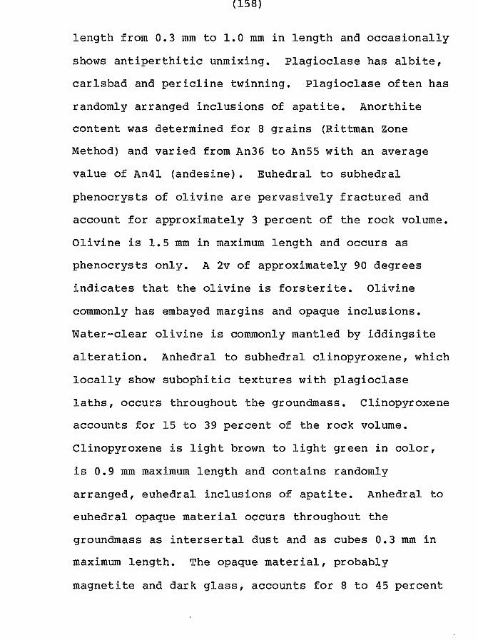
l e n g t h from 0.3 mm t o 1 . 0 mm i n l e n g t h and o c c a s i o n a l l y
shows a n t i p e r t h i t i c unmixing . P lag ioc lase has a lb i te ,
c a r l s b a d and p e r i c l i n e t w i n n i n g . P l a g i o c l a s e o f t e n h a s
randomly arranged inclusions of a p a t i t e . A n o r t h i t e
c o n t e n t was determined for 8 gra ins (Ri t tman Zone
Method) and var ied f rom An36 t o An55 w i t h an average
va lue of An41 (andes ine) . Euhedra l t o subhedra l
phenocrys ts of o l i v i n e are pe rvas ive ly f r ac tu red and
account for approximately 3 p e r c e n t of t h e rock volume.
O l i v i n e is 1.5 mm i n maximum l e n g t h and occur s as
phenocrys ts on ly . A 2v of approximately 90 degrees
i n d i c a t e s t h a t t h e o l i v i n e is f o r s t e r i t e . O l i v i n e
commonly has embayed margins and opaque inclusions.
Water -c lear o l iv ine is commonly mantled by i d d i n g s i t e
a l t e r a t ion . Anhedra l t o subhedral c l inopyroxene, which
l o c a l l y show s u b o p h i t i c t e x t u r e s w i t h p l a g i o c l a s e
la ths , occurs throughout the groundmass. Cl inopyroxene
accounts €or 15 t o 39 p e r c e n t of t h e rock volume.
Clinopyroxene is l i g h t brown t o l i g h t g r e e n i n color,
i s 0 .9 mm maximum l e n g t h and contains randomly
a r r anged , euhedra l i nc lus ions of apa t i te . Anhedra l t o
euhedral opaque mater ia l occurs throughout the
groundmass as i n t e r s e r t a l d u s t and a s cubes 0.3 mm i n
maximum leng th . The opaque material, probably
magnet i te and dark glass , accounts for 8 t o 45 p e r c e n t
of the rock volume. Anhedral to subhedral calcite has
been deposi ted i n amygdules and resembles blocky spar
a s desc r ibed by Folk ( 1 9 7 4 ) .
upper Cooling U n i t
The upper coo l ing u n i t of t h e A-L Peak t u f f is a
moderately to poorly welded, crystal-poor , pumice-r ich,
r h y o l i t i c , a s h - f l o w t u f f . H a r r i s o n (1980) has
c o r r e l a t e d t h e u p p e r c o o l i n g u n i t t o t h e p i n n a c l e s
member of t h e A-L Peak Tuff. The upper cooling u n i t is
e q u i v a l e n t t o t h e t u f f of Wahoo Canyon a s desc r ibed by
Fodor (1975) and a s mapped by Lopez (1975) . The upper
coo l ing u n i t is c o r r e l a t i v e t o p o r t i o n s of Tdh5 and
Tdh7 a s mapped by Givens (1957) and has been correlated
t o Tdrp2 of Stearns (1962) by Fodor (1975). The upper
coo l ing u n i t is a mul t ip le - f low s imple cool ing u n i t i n
t he s tudy a r ea .
The upper cooling u n i t c rops ou t as pervas ive ly
j o i n t e d l e d g e s and south-facing dip s lopes throughout
t h e a r e a . The u n i t forms a discontinuous pattern of
ou tcrops th roughout the cen t ra l por t ion of t he s tudy
a r e a , l o c a l i z e d a l o n g t h e highest peaks and r idges .
The un i t has a maximum th ickness of 1 2 m i n t he s tudy
a r e a and covers approximately 0.65 square k i lometers of
out , c rop a rea . The upper cool ing un i t conform: nbly
o v e r l i e s t h e v o l c a n i c l a s t i c rocks which occupy t h e
in te rva l be tween the upper and lower cool ing un i t s and
u n d e r l i e s a th in l ayer o f pebble conglomera te . The
uni t unconformably over l ies t h e Hells Mesa T u f f where
it was l o c a l i z e d i n a 120 m deep pa leoval ley exposed on
h i l l 7443 f t (Secs.23 and 2 4 , T.1N. , R.8W.).
I n hand spec imen, the upper cool ing un i t var ies
from l i g h t g r a y (N7) or v e r y l i g h t g r a y (N8) when f r e s h
t o moderate ye l lowish brown (10YR 5/4) when weathered.
Pumice fragments and phenocrysts of s a n i d i n e and q u a r t z
are v i s i b l e i n hand specimen. Pumice f r agmen t s a s much
as 3 cm long have been observed in t h e u n i t . Samples
from h i l l 7101 (Sec.26, T . lN . , R.8W.) are n o t i c e a b l y
e n r i c h e d i n s i l i c a and opaque mineral content. This
enrichment is secondary and maybe due t o t h e u n i t s
proximi ty t o a suspec ted f rac ture zone .
I n t h i n s e c t i o n , t h e u p p e r c o o l i n g u n i t is
p o r p h y r i t i c w i t h phenocrysts of s a n i d i n e , b i o t i t e ,
p lag ioc lase and opaque minera ls account ing for 1 t o 4
p e r c e n t of t h e rock volume (Table 4 ) . No q u a r t z was
o b s e r v e d i n t h i n s e c t i o n . Groundmass c o n s i s t s of
wel l -deve loped devi t r i f ica t ion products , vapor-phase
mine ra l s , g l a s s , and opaque dus t . L i th i c f r agmen t s a r e
p r e s e n t b u t n o t n e a r l y as abundant as i n t h e lower
coo l ing un i t . San id ine accoun t s for 1 t o 3 p e r c e n t of
t h e rock volume and is t h e most abundant phenocryst .
Euhedral t o subhedra l s an id ine phenoc rys t s , 1 .5 mm i n
maximum l e n g t h , commonly show car lsbad twinning and
p e r t h i t i c unmixing. Fracturing is common i n s a n i d i n e
phenocrysts which also have e i ther s h a r p or corroded
margins tha t are o c c a s i o n a l l y embayed. B io t i t e ,
p l a g i o c l a s e and opaque minerals are a l l p r e s e n t i n
minor amounts. Subhedral b i o t i t e , 0.7 mm i n maximum
l e n g t h , h a s s h a r p or corroded margins which are
o c c a s i o n a l l y embayed. Bio t i te is pleochroic and has
colors ranging f rom reddish brown to dark brown.
P l a g i o c l a s e p h e n o c r y s t s 0 . 2 mm i n maximum l e n g t h are
less abundant than b io t i te phenocrysts and commonly
exh ib i t co r roded marg ins . P l ag ioc la se is normally
zoned and e x h i b i t s a l b i t e t w i n s . A n o r t h i t e c o n t e n t was
determined for 4 gra ins (Ri t tman Zone Method) which
y i e l d e d an a v e r a g e a n o r t h i t e c o n t e n t of An19
(o l igoc la se ) . Subhedra l b l ebs of opaque minerals, 0.25
mm i n maximum length account for the remainder of t h e
phenocrys t conten t .
Groundmass and l i t h i c fragments account for t h e
remaining 96 t o 99 p e r c e n t of t h e rock volume.
Wel l -deve loped , low-bi re f r ingence devi t r i f ica t ion

Table 4 . Modal a n a l y s e s i n volume percent of t h e u p p e r c o o l i n g u n i t of t h e A-L Peak Tuff
wc-1 wc- 2 wc- 3
T o t a l p h e n o c r y s t s 3.9 1.3 2 .2
S a n i d i n e 3.2 1.0 1.8
P l a g i o c l a s e 0 . 1 0 .1 (An%) (N.D.)" ( 2 1 )
0 . 1 ( 1 8 )
B i o t i t e 0 . 1 0 . 1 0 . 1
Opaques 0 .5 0 . 1 0 .2
L i t h i c s 0 .4 0.4 0 .2
P o i n t s c o u n t e d 2000 2000 2000
. ..
* no t de t e rmined
. . . .
products dominate the groundmass. Pumice and glass
s h a r d s h a v e a x i o l i t i c t e x t u r e s and aggrega tes of
s p h e r u l i t e s a r e l o c a l l y p r e s e n t . L i t h i c fragments
account for less than 1 pe rcen t of the rock volume.
L i t h i c fragments are rounded, 5.0 mm i n maximum leng th
and c o n s i s t of l a t h s of p lag ioc lase sur rounded by an
opaque groundmass.
Younger T e r t i a r y Rocks
Tert iary rocks younger than the upper cool ing uni t
of the A-L Peak Tuff c o n s i s t of a 0 .5 m bed of
conglomerates which unde r l i e s a 1 m th ick basa l t f low.
These younger u n i t s form i s o l a t e d o u t c r o p s on h i l l 7545
f t (Sec.26,T.lN., R.8W.) and are always found
toge the r . The basa l t f low is c o r r e l a t i v e t o p o r t i o n s
of Givens’ (1957) Tdh6 and a r e p r o b a b l y c o r r e l a t i v e t o
t h e b a s a l t of Blue Mesa (Harr i son , 1980).
I n t r u s i v e s
Monol i th ic , hornblende andes i te b recc ias of t h e
upper member of t h e Dog Springs volcanic complex are
the on ly i n t rus ive rocks i n t he s t u d y area. These
b recc ia s i n t rude the upper and lower members of t h e Dog
Springs volcanic complex and a r e c o r r e l a t i v e t o t h e
r h y o d a c i t e i n t r u s i v e s of Harr i son (1980) . Monol i th ic
hornblende andes i te breccia i n t r u s i o n s o c c u r a s d ikes
and small domes. Due t o poor exposure , in t rus ives a re
d i f f i c u l t t o d i s t i n g u i s h from t h e i r e x t r u s i v e
e q u i v a l e n t s . Good exposure of a b r e c c i a d i k e is
provided by an ou tcrop loca ted on the southeas t s ide of
Dog Spr ings Canyon (Sec.28,T. 2N., R. 8W.) (f ig.13) . C r o s s - c u t t i n g c o n t a c t r e l a t i o n s h i p s of hornblende
a n d e s i t e breccias wi th lower member t u f f breccias,
a long t he no r theas t marg in of the s tudy area (Sec.36,
T.2N., R.8W.), p robab ly r ep resen t the margins of two
small domes. An outcrop a long the margin of t h e
easternmost of t h e s e two bodies is s h e e t j o i n t e d , h a s a
p re fe r r ed a l ignmen t of e l o n g a t e m i n e r a l s p a r a l l e l t o
s h e e t j o i n t s , a n d c o n t a i n s x e n o l i t h s of baked c l a y
s i m i l a r t o the count ry rock t h a t s u r r o u n d s it.
Abnormally t h i c k accumulations of hornblende andes i te
b r e c c i a are s c a t t e r e d a l o n g t h e n o r t h e r n and e a s t e r n
margins of t h e s t u d y a r e a and may r ep resen t sma l l
stocks, domes or f i s s u r e s ( f i g . 3 6 ) .
4
Outcrops of t h e b r e c c i a s a r e g e n e r a l l y m a s s i v e and
o n l y o c c a s i o n a l l y show d i s c o r d a n t r e l a t i o n s h i p s . I n
hand specimen, t h e hornblende andes i tes are brownish
r e d when weathered and dark o l i v e g r e e n when f r e s h .
Dark-green t o black phenocrys ts of hornblende and
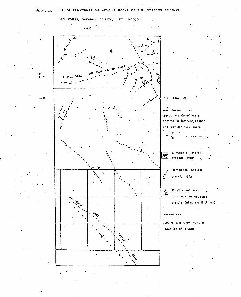
. . . .
.. . .
F~GURE 35 hlAIJoi( STRUCTURES AND ,uITL5lVE ROCKS OF THE WESTERN GALLINAS
MOUNTAINS, SOCORRO COUNTY, NEW MZXICO
e .
.e- T2N
T.1 N.
..
'. . .
.. .
EXPLANAilON
., Harnblende onderitc I'
4 breccio d i k e Td
r
,
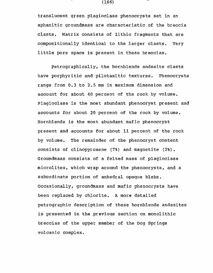
t r ans lucen t g reen p l ag ioc la se phenoc rys t s set in an
aphanitic groundmass are characterist ic of t h e b r e c c i a
c l a s t s . M a t r i x c o n s i s t s of l i t h i c f r a g m e n t s t h a t a r e
c o m p o s i t i o n a l l y i d e n t i c a l t o the l a r g e r clasts. Very
l i t t l e pore space is p r e s e n t i n these b recc ia s .
Pe t rog raph ica l ly , t he ho rnb lende andes i t e clasts
have po rphyr i t i c and p i l o t a x i t i c t e x t u r e s . P h e n o c r y s t s
range from 0.3 t o 2.5 mm i n maximum dimension and
account for about 40 p e r c e n t of t h e rock by volume.
P l a g i o c l a s e is t h e most abundant phenocryst present and
accounts for about 20 p e r c e n t of t h e rock by volume.
Hornblende is t h e most abundant mafic phenocryst
present and accounts for about 11 p e r c e n t of t h e rock
by volume. The remainder of t he phenoc rys t con ten t
c o n s i s t s of cl inopyroxene ( 7 % ) and magnetite ( 2 % ) .
Groundmass c o n s i s t s of a fe l ted mass of p l a g i o c l a s e
microlites, which wrap around the phenocrysts , and a
s u b o r d i n a t e p o r t i o n of anhedral opaque blebs.
Occasionally, groundmass and mafic phenocrysts have
been replaced by c h l o r i t e . A more d e t a i l e d
p e t r o g r a p h i c d e s c r i p t i o n of these hornblende andes i tes
i s p r e s e n t e d i n t h e p rev ious s ec t ion on mono l i th i c
b r e c c i a s of the upper member of t h e Dog Spr ings
volcanic complex.
S u r f i c i a l D e p o s i t s
Piedmont Deposits
Piedmont deposi ts consis t of an unconsol ida ted ,
heterogeneous mixture of volcanic f ragments i n a mat r ix
o f s and t o s i l t - s i zed de t r i t u s . Vo lcan ic f r agmen t s ,
c o n s i s t i n g of b a s a l t i c - a n d e s i t e s and t u f f s , a r e
subrounded to angu la r and range f rom granule to boulder
on the Wentworth scale. T u f f f ragments genera l ly
c o n s i s t of t h e more r e s i s t a n t t u f f s which occur above
t h e Dog Springs volcanic complex and there is a notab le
absence of rock types of the Dog Spr ings vo lcanic
complex. Piedmont d e p o s i t s u s u a l l y a r e c o a r s e r and
form s teeper s lopes near the i r source . Loca l ly one
c l a s t t y p e may dominate b u t t h i s c a n u s u a l l y be
a t t r i bu ted t o p rox imi ty t o bed rock exposure or poss ib ly
t o a func t ion of t h e c l a s t s d u r a b i l i t y .
Within the s tudy area, the piedmont deposi ts have
been mapped a s s i x s e p a r a t e u n i t s . Four of the u n i t s
a r e l o c a l i z e d t o t h e s o u t h of t he d ra inage d iv ide
formed by the r i dge no r th of Rock House Canyon and w i l l
be re fer red to as the southern p iedmonts . The
remain ing un i t s will be r e f e r r e d t o a s t h e n o r t h e r n
piedmonts. No age re la t ionship can be determined
between the northern and southern piedmonts within the
s t u d y a r e a .
The southern p iedmonts cons is t of four
g e o m o r p h i c a l l y d i s t i n c t s u r f a c e s . The oldest southern
piedmont covers approximately 1 0 squa re kilometers i n
the southwes t corner of t h e s t u d y a r e a . T h i s u n i t is
c o r r e l a t i v e t o t h e younger piedmont deposit of Har r i son
(1980) and is mantled by t h e Augustin so i l (479) as
mapped by the U n i t e d S t a t e s So i l Conserva t ion Serv ice
(Job no. 35902). The u n i t is composed predominantly
of sand to s i l t - s i z e d d e t r i t u s t h a t i s r edd i sh brown
nea r t he l and surface, where r e s idua l concen t r a t ions of
volcanic f ragments occur , and dark brown a meter below
t h e s u r f a c e . The u n i t forms a gen t l e , sou th - fac ing ,
grass-covered slope.
The next younger piedmont covers 2 squa re km of
t h e s t u d y a r e a and is found near t h e base of t h e h i l l s
t ha t su r round t he North L a k e embayment and R o c k House
Canyon. The u n i t is mantled by t h e Majada so i l (456)
as mapped by t h e S o i l C o n s e r v a t i o n S e r v i c e ( J o b no.
35902). The uni t fo rms modera te ly steep g r a s s , j u n i p e r
and pinion covered slopes and has a higher clast t o
m a t r i x r a t io than the Augus t in so i l (479) of t h e oldest
piedmont.
The next younger piedmont is confined t o the Nor th
Lake bas in and covers approximately 2 .6 squa re
kilometers of t h e s t u d y a r e a . The u n i t is similar to
the Augustin soils (479) in compos i t ion bu t can be
dis t inguished f rom the older piedmont by its’ lower
topograph ic pos i t i on . The u n i t is mantled by the
Manzano ( 4 2 4 ) s o i l as mapped by t h e S o i l C o n s e r v a t i o n
Se rv ice ( Job no. 35902) and forms moderately t o g e n t l y
s lop ing , g ra s s cove red s lopes .
The youngest piedmont of t h e southern piedmonts
covers approximately 9 squa re kilometers i n t h e
s o u t h e a s t c o r n e r of t h e s t u d y area and is r e s t r i c t e d t o
t h e lower p o r t i o n of Rock House Canyon and t h e North
L a k e embayment. The un i t fo rms ve ry gen t l e s lopes and
is composed p r i m a r i l y of s i l t and sand-sized d e t r i t u s
a long wi th a few l a r g e r clasts. The u n i t is mantled by
t h e Manzano ( 4 2 4 ) s o i l a s mapped by t h e S o i l
Conserva t ion Serv ice (Job no. 35902) and r e p r e s e n t s
the c u r r e n t l y a c t i v e a l l u v i a l surface.
Unconsol idated debris mant les an ex tens ive
piedmont surface p r e s e n t across the no r the rn po r t ion of
t h e s t u d y area which forms t h e oldest no r the rn
p iedmont . Det r i tus cons is t s of b a s a l t i c - a n d e s i t e and
upper sec t ion t u f f f r agmen t s set i n a matrix of sand
and s i l t . The deb r i s cove r s app rox ima te ly 4 squa re
k i lome te r s of the s tudy a rea and is e s p e c i a l l y well
p re se rved no r th of t h e Chavez Well-Thompson Canyon
f a u l t . The u n i t i s mantled by the Luzena S o i l (442) a s
mapped by t h e S o i l C o n s e r v a t i o n S e r v i c e ( J o b no.
35902), and is c o r r e l a t i v e t o the San ta Fe Formation of
Givens (1957) and the older piedmont uni t of Har r i son
(1980). Givens (1957) and Harr ison (1980) both
reported th i cknesses of 46 m for t h e u n i t . D i f f i c u l t y
i n l o c a t i n g t h e b a s e of t h e u n i t o n s t e e p ,
colluvium-covered slopes i n t h e s t u d y area precluded
th i ckness de t e rmina t ion .
The youngest northern piedmont is located near the
head of Middle Canyon and o c c u r s i n t e r m i t t e n t l y a l o n g
the base of t he no r the rn side of the d ra inage d iv ide .
The piedmont covers approximately 3 squa re kilometers
o f t h e s t u d y a r e a and is mantled by the Luzena S o i l
(442) a s mapped by t h e S o i l C o n s e r v a t i o n S e r v i c e ( J o b
no. 35902). The uni t forms moderate t o g e n t l e slopes
covered by g r a s s and groves of pinon and juniper trees.
Clasts of t h e t u f f of Rock House Canyon c h a r a c t e r i z e
t h e steeper slopes w i t h f i n e r - g r a i n e d d e t r i t u s
domina t ing t he gen t l e slopes and f l a t t e r p o r t i o n s of
t h e u n i t . I n c o n t r a s t t o the southern piedmonts , the
d e p o s i t a p p e a r s t o be on ly a t h i n v e n e e r over t h e
unde r ly ing bed rock .
P laya Deposits
Recent l ake sediments composed of c lay and silt
a r e p r e s e n t i n t h e N o r t h L a k e B a s i n . C u l t u r a l a c t i v i t y
and ac t ive p i edmont s have obscu red much of t h e
p a l e o - s h o r e l i n e of a n c i e n t N o r t h L a k e . T e n t a t i v e
i d e n t i f i c a t i o n of two p a l e o - s h o r e l i n e s o u t s i d e of t h e
s t u d y a r e a i n d i c a t e s t h a t s h o r e l i n e s e x i s t e d - a t tire..
7040 f t and 7020 f t e l eva t ions (Weber , 1979 , o r a l
commun .) . Aerial pho tographs t ha t p reda te ag r i cu l - l i u ra l
a c t i v i t y show a d i s t i n c t tonal anomaly a t a b o u t t h e
7020 f t e i e v a t i o n a n d t h u s s u p p o r t t h i s a s t h e g e n e r a l
l o c a t i o n of t h e p a l e o - s h o r e l i n e .
Older Alluvium
O l d e r a l l u v i a l d e p o s i t s , s i m i l a r t o r e c e n t l y
depos i t ed a l luv ium, has been mapped i n R o c k House
Canyon where i t h a s b e e n i s o l a t e d a b o v e t h e c u r r e n t l y
a c t i v e a l l u v i a l s u r f a c e . T h e u n i t c o v e r s a b o u t 2 . 6
squa re kilometers o f t h e s t u d y a r e a .

Talus and Colluvium
Ta lus and colluvium occur on most of t h e s l o p e s i n
t h e s t u d y a r e a and obscure l a r g e p o r t i o n s of t h e
bedrock geology. This phenomenon is e s p e c i a l l y
well-developed on t h e slopes t h a t c o v e r t h e Dog Spr ings
v o l c a n i c c o m p l e x , t h e v o l c a n i c l a s t i c rocks of Chavez
Canyon and the m i d d l e v o l c a n i c l a s t i c rocks. Talus and
col luvium is mapped where it has completely obscured
t h e unde r ly ing geo log ic r e l a t ionsh ips .
Alluvium
N o pe renn ia l s t r eams e x i s t i n t h e s t u d y a r e a , b u t
i n t e r m i t t e n t flow does occur a f t e r h e a v y r a i n f a l l .
C u r r e n t l y t h e a r e a is undergoing degradat ion b u t i n t h e
1800’s t h e a r e a was undergoing aggradation (Givens,
1 9 5 7 ) . Recent terraces and c u r r e n t l y a c t i v e stream
channels have been mapped as qua te rna ry a l luv ium. In
t h e s t u d y area, a l l u v i u m c o n s i s t s of poor ly
conso l ida t ed s ands and g r a v e l s a s much as 6 m t h i c k .
~ STRUCTURE
The western p o r t i o n of the Gal l inas Mounta ins ,
which occupy the s tudy area, are c u t by nor thwes t ,
nor theas t and eas t -nor theas t - t rending h igh-angle normal
f a u l t s ( f i g . 3 6 ) . A south-dipping homocline occupies
the no r the rn po r t ion of t h e s t u d y a r e a and a
southeas t -p lunging sync l ine occupies the sou the rn
p o r t i o n . No evidence of pre-Oligocene tectonic e v e n t s
i s p r e s e n t i n t h e s t u d y a r e a .
Folds
The sou the rn po r t ion of t h e s t u d y a r e a is occupied
by t h e e a s t e r n arm of a broad southeast-plunging
s y n c l i n e . The s y n c l i n e is bounded on t h r e e s i d e s by
high-angle normal faul ts and disappears beneath the San
Augus t in P l a ins on t h e f o u r t h . T o t h e west of t h e
s t u d y a r e a , t h e s y n c l i n e h a s b e e n down f a u l t e d and
d i s r u p t e d by a north-trending, complexly faulted zone
mapped by Har r i son ( 1 9 8 0 ) . To t h e east of the s tudy
a r e a , r e c o n n a i s s a n c e r e v e a l e d t h a t t h e s y n c l i n e is
u p l i f t e d and terminated a long the western G a l l i n a s
f a u l t of Givens (1957) . Within, and t o t h e west and
east of t h e s t u d y a r e a , t h e n o s e of t h e s y n c l i n e is c u t
by the east-northeast- t rending, down-to- the-north
Chavez Well-Thompson Canyon fault . North of the Chavez
Well-Thompson Canyon f au l t , sync l ina l deve lopmen t , i f
i t occurred a t a l l , h a s been masked by poor exposure,
f a u l t i n g and steep i n i t i a l d ips i n t h e rocks of t h e Dog
Spr ings vo lcan ic complex.
I n i t i a l s y n c l i n a l d e v e l o p m e n t b e g a n d i r e c t l y
fo l lowing the emplacement of t h e Hells Mesa T u f f , about
33 m.y. B.P. (Harr i son , 1 9 8 0 ) . A t t h i s time, an
e r o s i o n a l s u r f a c e t r a n s e c t e d by pa leova l l eys as much as
a hundred meters deep (Harr i son , 1980; t h i s r e p o r t )
formed along the top of the Hells Mesa Tuff . Harr i son
r e p o r t e d a sou theas t t r end o f pa l eova l l eys t o t h e west
of t h e s t u d y area and t h a t u n i t s above the Hells Mesa
Tuf f t h in t o t h e n o r t h . H a r r i s o n c o n c l u d e d t h a t t h i s
was i n d i c a t i v e of syncl inal development . Within the
s t u d y a r e a , the l o c a l i z a t i o n of t h e v o l c a n i c l a s t i c
rocks, occurring between the upper and lower coo l ing
u n i t s of t h e A-L Peak Tuff, near the s y n c l i n e a x i s , is
a lso i n d i c a t i v e of syncl inal development .
Paleovalleys, presumably formed following t h e
emplacement of t h e Hells Mesa T u f f , were a c t i v e l y
e roded i n to l a t e A-L Peak time. T h i s r e l a t i o n s h i p i s
apparent from p a l e o v a l l e y s i n which a l l of t h e rocks
between the upper cool ing uni t of t h e A-L Peak Tuff and
the Hells Mesa Tuff have been removed, such as on hill
7443 ft (Sec.23 and 24, T.1N. , R.8W.). Thus synclinal
development was active at least until late A-L Peak
time. Non-deposition of the tuff of South Canyon which
occurs directly to the south of the study area, and
presumably pinched out against the southeast plunging
syncline, provides a possible upper limit for the
period of synclinal development. The initiation of
basaltic-andesite volcanism in the area, concurrent
with synclinal development, reflects the begining of
regional extension and the formation of the Rio Grande
rift.
Faults
High-angle, east-northeast-trending normal faults
and fractures are common throughout the northern
portion of the study area and form a system of
conjugate faults and fractures dominated by the Chavez
Well-Thompson Canyon fault. The Chavez Well-Thompson
Canyon fault has a maximum down-to-the-north
displacement of 366 m and can be traced for several
kilometers to the east and west of the study area.
Numerous other transverse faults in the study area
display both down-to-the-north and down-to-the-south
displacement but they are rarely traceable for over a
few kilometers. Laroche (1980) reported similar
t r a n s v e r s e f a u l t s i n t h e n o r t h e a s t e r n G a l l i n a s
Mountains as d i d Lopez (1975) and Bornhorst (1976) t o
the southwes t of the s t u d y area. Reconnaissance t o t h e
east of t h e s t u d y area and ana lys i s of a e r i a l p h o t o s
and topographic maps sugges t t h a t such t r ansve r se
f a u l t s a r e common throughout the Gal l inas Mountains .
The Chavez Well-Thompson Canyon f a u l t h a s g r e a t e r
d i sp l acemen t and l a t e ra l ex t en t t han any f au l t i n t he
s t u d y area. I n i t i a l a c t i v i t y a l o n g t h e f a u l t may have
begun dur ing the d e p o s i t i o n of t h e v o l c a n i c l a s t i c r o c k s
of Chavez Canyon. A t t h i s time it was a growth f a u l t
as evidenced by t h e g r e a t e r t h i c k n e s s of sediments
depos i t ed on t he down-thrown s i d e of t h e f a u l t .
A c t i v i t y c o n t i n u e d a l o n g t h e f a u l t u n t i l l a t e T e r t i a r y
or e a r l y Q u a t e r n a r y time as demonstrated by t h e
t e rmina t ion of piedmont gravels a long the faul t .
The Chavez Well-Thompson Canyon f a u l t commonly
d i s p l a y s r e v e r s e d r a g . Numerous sugges t ions for t h e
o r i g i n of reverse drag have been out l ined by Hamblin
(1965) , who concluded t h a t rather than being due t o
l o c a l l y p r e s e n t c o n d i t i o n s s u c h a s s a l t r i d g e s , f a u l t e d
monocl ines , compress ion a f te r fau l t ing , double
movement, e las t ic rebound, or f a u l t e d a n t i c l i n e s ,
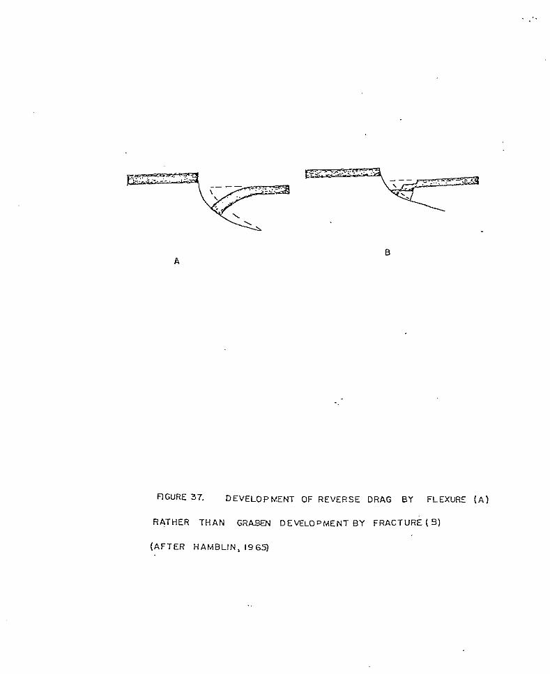
a
flGURE 37. DEVELOPMENT OF REVERSE DRAG BY FLEXURE ( A )
RATHER THAN GRW DEVELOPMENT BY FRACTURE (9 )
(AFTER HAMBLIN, 1965)
r e v e r s e d r a g was a much more widespread phenomenon than
s u c h f o r t u i t o u s s i t u a t i o n s would allow. Hamblin
suggested t h a t r eve r se d rag is t h e resul t of movement
normal t o an arcuate f a u l t p l a n e which approaches
h o r i z o n t a l a t depth. Subsequent f lexing rather than
f r a c t u r i n g results i n t h e f o r m a t i o n of r eve r se d rag
( f i g . 3 7 ) . Theoretical ev idence for such a rcua te
f a u l t p lanes has been presented by numerous workers
(Evison, 1959 and Kanizay, 1962). Cloos (1968)
exper iments wi th c lay b locks t h a t were p u l l e d a p a r t on
t h i n t i n s l a b s t h a t s l i d e b e n e a t h o n e a n o t h e r formed
r e v e r s e d r a g a n d f a u l t p a t t e r n s r e m a r k a b l y similar t o
t r a n s v e r s e f a u l t s mapped i n t h e s t u d y a r e a .
The experiments of Cloos (1968) sugges t tha t a
north-northwest movement normal t o t h e f a u l t s y s t e m
occurred. Such movement might have been due t o t h e
northwest d r i f t and clockwise r o t a t i o n of the Colorado
P l a t e a u as p o s t u l a t e d by Chapin (1971b). However,
t iming of i n i t i a l f a u l t i n g seems too e a r l y for opening
of t h e R i o Grande r i f t and r o t a t i o n of t h e Colorado
P l a t e a u . A l t e r n a t i v e l y t h e s e t r a n s v e r s e f a u l t s may
have o r ig ina t ed a s str ike-slip f a u l t s a l o n g a zone of
decoupling between the Colorado Plateau and the
ba thol i th ica l ly anchored Dat i l -Mogol lon vo lcanic f ie ld .
T h i s s t r i ke - s l ip movement may have been due t o the
clockwise rotation of the Colorado Plateau, in which
case it would be left-lateral, or to the opening of the
southern segment of the Rio Grande rift an order of
magnitude greater than the central segment (Chapin,
1978), in which case it would be right-lateral.
Additional mapping to the east and west is needed to
further document the fault patterns, timing, and sense
of displacement.
Numerous high-angle northwest- and
northeast-trending normal faults, which are more
characteristic of the regional fault pattern, also
transect the study area. These north-trending faults
trend between N.45W. and N.45E. , with northwest-trending faults more common. These faults
are rarely traceable for more than 3 km and show
displacement ranging from 6 to 150 m, with
northwest-trending faults generally showing greater
displacement. Cross-cutting relationships suggest that
these faults were active concurrently throughout part
of their history. Northeast-trending faul-ts cut no
units older than the Hells Mesa Tuff in the study area,
whereas northwest-trending faults, such as the North
Lake fault, disrupt late Tertiary to Quaternary units
(fig.38).

F i g u r e 38. Photograph of North Lake Fault scarp.
ALTERATION MINERALIZATON AND ECONOMIC POTENTIAL
A l t e r a t i o n and m i n e r a l i z a t i o n i n t he s t u d y a r e a is
a l m o s t e n t i r e l y r e s t r i c t e d t o t h e Dog Spr ings vo lcan ic
complex. The only except ion is a m i l d l y s i l ic i f ied
o u t c r o p of the uppe r coo l ing un i t of t h e A-L Peak Tuff
l o c a t e d i n t h e North L a k e embayment (Sec.26, T l N . ,
RBW.). A l t e r a t i o n m i n e r a l s i n the Dog Spr ings vo lcan ic
complex c o n s i s t of s i l i c a , c h l o r i t e , ser ic i te , e p i d o t e
and c a l c i t e . Mild p r o p y l i t i c a l t e r a t i o n is p r e s e n t
throughout the Dog Spr ings vo lcan ic complex and
g e n e r a l l y i n c r e a s e s i n i n t e n s i t y n e a r known or
suspec ted fracture zones. Widespread green s ta ining of
t h e r o c k s i n t h e Dog Spr ings vo lcan ic complex has been
a t t r i b u t e d t o the p resence of ce l adon i t e (Har r i son ,
1980) and epidote.
Three types o f ve in minera l iza t ion are p r e s e n t i n
t h e s t u d y a r e a . The most common v e i n s are composed of
calci te w i t h no other v i s i b l e m i n e r a l i z a t i o n p r e s e n t .
Calci te ve ins are most abundant in t h e l a c u s t r i n e rocks
of Middle Canyon. C a l c i t e v e i n s are a s much a s 1 0 cm
wide and can be traced for a s much as 15 m ( f ig .39)
Well-formed c r y s t a l faces i n d i c a t e t h a t t h e v e i n s are
t h e r e su l t of open-space f i l l i n g of f r a c t u r e s . Good

,
F i g u r e 39. Photograph of a ca lc i te v e i n i n t h e l a c u s t r i n e rocks of Middle Canyon.
exposures of t h e calci te v e i n s a r e located along t h e
northern boundary of the s tudy area. Blue-green veins
of chalcedony are p r e s e n t i n t h e u p p e r member b r e c c i a s
of t h e Dog Spr ings vo lcan ic complex. These veins are
less than 25 mm in width, d iscont inuous, and appear t o
occupy zones of secondary fractures. No v i s i b l e
m i n e r a l i z a t i o n i s p r e s e n t i n t h e chalcedony veins which
sometimes e x h i b i t colloform tex tu res . Sma l l
d i scon t inuous hema t i t e -magne t i t e ve in l e t s ( f i g .40 )
a re exposed th roughout the Dog Spr ings vo lcan ic complex
a n d a r e e s p e c i a l l y well deve loped i n t he mudflow
d e p o s i t s of the upper member. These v e i n l e t s are
g e n e r a l l y zoned with hematite walls and magnet i te
cores. V e i n l e t s are discont inuous and rarely exceed 1 2
mm in w id th . F i r e a s s a y of v e i n l e t m a t e r i a l collected
near t h e mouth of Middle Canyon (of Sec.26, T.2N., R.8W.)
y i e l d e d a s i l v e r v a l u e of 3.20 oz/ton and a gold va lue
of 0 . 0 1 oz / ton . Fire a s s a y of a l t e r e d material,
composed predominately of c l a y and minor magnetite,
which surrounds some of t h e v e i n l e t s y i e l d e d n o s i l v e r
and only a trace of gold. Manganese dendrites and
s t a i n s are common throughout the s tudy a rea .
No other s i g n i f i c a n t o c c u r r e n c e s of m i n e r a l i z a t i o n
are p r e s e n t w i t h i n t h e s t u d y area b u t the p resence of
ground water and t h e poss ib l e p re sence of uranium add

Figure 40. Photograph of hematite-magnetite veinlets in a mudflow deposit in the upper member of the Dog Springs volcanic complex. Note that the cores are magnetite and the walls are hematite.
cons ide rab ly t o the economic po ten t ia l of t h e a r e a .
Ground water is abundant in t h e s t u d y area and thus
makes ca t t l e ranching economica l ly feas ib le . Two
s p r i n g s flow year round in Chavez Canyon and t h e
r e l a t i v e l y s h a l l o w w a t e r t a b l e i n t h e n o r t h e r n p o r t i o n
of t h e s t u d y area has been tapped for seve ra l wa te r
wells. The Nor th L a k e embayment provides a semiclosed
d ra inage bas in from which several deep water wells pump
l a r g e amounts of i r r i g a t i o n w a t e r . The water is used
t o i r r i g a t e h a y and a l f a l f a which is grown i n t h e North
L a k e Basin for c a t t l e feed.
Small uranium occurrences in the Eocene Baca
Formation are well documented (Anonymous, 1959; Chapin
and o thers , 1979) a long t h e southern margin of t h e
Co lo rado P l a t eau . No exposures of the Baca Formation
a r e p r e s e n t i n t h e s t u d y a r e a b u t e x p o s u r e s o c c u r a t
Mar t in Ranch approximately 3 km no r th o f t he s tudy
area. I f the Dog Spr ings vo lcan ic Complex is a
volcano- tec tonic depress ion or a cauldron the chances
of f i n d i n g t h e Baca Formation a t a reasonable depth a r e
s l i g h t , b u t i f the Dog Spr ings vo lcan ic complex i s a
wedge of in te rmedia te composi t ion vo lcanic breccias and
mudflow, d e p o s i t s t h e Baca Formation may be a t a
reasonable depth and possibly below the zone of s u r f a c e
ox ida t ion , t hus g rea t ly enhanc ing t h e p o s s i b i l i t y of

economic uranium occurrences. Some uranium potential
may exists in the Tertiary or Quaternary sediments that
underlie the North Lake Basin.
CONCLUSIONS
Geologic Evolution of the northwestern Gallinas
Mountains
Stratigraphic and structural data from the study
area suggest the following sequence of events for the
evolution of the northwestern Gallinas Mountains.
1) During early Oligocene time (38-33 m.y. 'B.P)
intermediate composition volcanism was active, along
the northern margin of the Datil-Mogollon volcanic
field. Initial activity resulted in the formation of
the lower member of the Dog Springs volcanic complex, a
thick sequence of tuff breccias. A thinner interval of
monolithic andesite breccias, andesitic mudflow
deposits, exotic blocks and interbedded sedimentary
rocks, referred to as the upper member of the Dog
Springs volcanic complex, was deposited upon the lower
member. The monolithic hornblende andesite breccias of
the upper member occur as intrusions and extrusives and
thus define a vent facies.
Alteration and mineralization are generally
limited to the rocks of the Dog Springs volcanic
complex. Small amounts of silver-bearing

magnetite-hematite veinlets are the only occurrence of
potentially valuable mineralization.
2) Concurrent with, and following the formation of the
Dog Springs volcanic complex, a period of deposition of
fluviatile sediments characteristic of a braided stream
environment began. Initial movement along
east-northeast trending high-angle normal faults such
as the Chavez Well- Thompson Canyon fault may have
begun at this time. Sedimentary structures indicate a
north-northwest transport direction for these
sedimentary rocks. Active volcanism shifted to the
southeast and southwest of the study area and
fluviatile deposition was interrupted momentarily
during the emplacement of the tuff of Rock House
Canyon, the tuff of Blue Canyon and the Hells Mesa
Tuff, but the generally northward transport direction
of the fluvial system was not disrupted.
3) Following emplacement of the Hells Mesa Tuff ( 3 3
m.y. B.P.), the formation of the Rio Grande rift
resulted in the formation of a broad southeast-plunging
syncline and an extensive erosional surface within the
region. The study area occupies the eastern flank of
this syncline. Local unconformities between the
volcaniclastic rocks of South Crosby Peak and the
various members of the A-L PeAk Tuff indicate that
deformation was active throughout A-L Peak time.
Deformation was concurrent with extrusion of the
basaltic andesite of Twin Peaks which marks the onset
of bimodal volcanism in the study area.
4 ) Development of high angle normal faults occurred
from late Oligocene into Holocene time. However fault
development has not been extensive in the study area
and large areas are relatively intact.
5) Volcanic activity ceased in the area after
deposition of the A-L Peak Tuff (30 m.y. B.P.) except
for emplacement of a thin basalt flow during Pliocene
(? ) time.
6 ) Extensive development of piedmont deposits occurred
from late Tertiary ( ? ) to the present. During this
period displacement along the North Lake fault dammed
the North Lake embayment and resulted in the formation
of a small playa.
Stratigraphic Correlations
Stratigraphic correlations of major volcanic units
in the northwestern Gallinas Mountains with other
volcanic units in the northeast corner of the
Datil-Mogollon volcanic field are summarized below.
Some of these correlations are diagrammatically
presented on Plate I1 (in pocket).
1) The Dog Springs volcanic complex is correlative to
the Spears Formation of Cather (1980), the lower
portions of the Spears Group as described by Lopez
(1975) and Bornhorst (1976), the latite facies of Datil
Formation as described by Willard (19571, portions of
the Spears Ranch Member of the Datil Formation of
Givens (1957) and portions of the Spears Member of the
Datil Formation of Tonking (1957).
2) The tuff of Rock House Canyon is correlative to the
tuff of Main Canyon (Harrison, 1980; Bornhorst, 1976
and Lopez, 1975) and the Tuff of Nipple Mountain
(Laroche, 1980; Wilkinson, 1978; Chamberlin, 1974 and
Brown, 1972) . 3 ) The tuff of Blue Canyon is correlative to the tuff
of Blue Canyon as mapped by Harrison (1980), Bornhorst
(1976) and Lopez (1975) , Tst2 as mapped by Mayerson (1979), and to Tdrspl as mapped by Stearns (1962).
4) The Hells Mesa Tuff is correlative, at least in
part, to the tuff of Rock Tank as mapped by Lopez and
Bornhorst (1979).

5) The pinnacles member of the A-L Peak Tuff is
correlative to the tuff of Wahoo Canyon as mapped by
Lopez and Bornhorst (1979) and Fodor (1975) (Harrison,
1980).
REFERENCES
Anderson, C.A., 1933, The Tuscan Formation of northern California: University of California Dept of Geological Sciences Bull., v. 23, p. 215-276.
Anonymous, 1959, Uranium deposits in the Datil
West-Central New Mexico: New Mexico Geological Mountains-Bear Mountains region, New Mexico, in
Society, 10th Field Conference, Guidebook, p. 135-143.
Atwater, T., 1970, Implications of plate tectonics for the Cenozoic tectonic evolution of western North America: Geological Society of America Bull. v. 81, p. 3513-3536.
Bates, R.L. , and Jackson, J.A., 1980, Glossary of Geology, (2nd edition): Falls Church, Virginia, American Geological Institute , 749p.
Bikerman, M., 1972, New K-Ar ages on volcanic rocks from Catron and Grant Counties, New Mexico: Isochron/West, no. 3, p. 9-12.
Burke, W.H. , Kenny, G.S. , Otto, J.B., and others, 1963, Mexico, in Socorro Region: New Mexico Geologicak :-:. Potassium-argon dates, Socorro and Sierra Counties, New
Society, 14th Field Conference, Guidebook, p. 224.
Bornhorst, T.J., 1976, Volcanic geology of the Crosby Mountains and vicinity, Catron County, New Mexico {unpublished N.S. thesis}: University of New Mexico, 113 p.
Brown, D.M., 1972, Geology of the southern Bear Mountains,
New Mexico Institute of Mining and Technology, 110 p. Socorro County, New Mexico {unpublished M.S. thesis}:
,
Cather, S.M., 1980, Petrology, diagenesis, and genetic
Reservation and vicinity, Socorro County, New Mexico stratigraphy of the Eocene Baca Formation, Alamo Navajo
{unpublished M.S. thesis}: University of Texas, Austin 243 p.
Chamberlain, R.M., 1974, Geology of the Council Rock District, Socorro County, New Mexico {unpublished M.S. thesis}: New Mexico Institute of Mining and Technology, 130 p.
Chapin, C.E., 1971a, K-Ar age of the La Jara Peak Andesite and it's possible significance to mineral exploration in the Magdalena Mining District, New Mexico: Isochron/west, v. 2, p. 43-44.
"" 1971b, The Rio Grande Rift, Part I: Modifications and
Conference, Guidebook, p. 191-201. additions: New Mexico Geological Society, 22nd Field
"" 1974, Composite stratigraphic column of the Magdalena
Open-File Report 4 6 . area: New Mexico Bureau of Mines and Mineral Resources
-"- 1979, Evolution of the Rio Grande Rift; a summary: - in Rieker, R.E., ed., Rio Grande rift; tectonics and magmatism, American Geophysical Union, Washington D.C., p. 1-5.
Chapin, C.E., and Wyckoff, B.S., 1969, Formation of a
volcanic field of central Colorado: in Abstracts for sixty-cubic-mile breccia sheet in the Thirtynine Mile
1968, Special Paper 121, Geological Society of America, p. 52.
Chapin, C.E., and Seager, W.R., 1975, Evolution of the Rio
Mexico Geological Society, 26th Field Conference, Grande Rift in the Socorro and Las Cruces areas: New
Guidebook, p. 297-391
Chapin, C.E., and Deal, E.G., 1976, The A-L peak Tuff, New Mexico: A composite ash-flow sheet: Geological Society of America Abstracts with Programs, v. 8, no. 5, p. 575.
Chapin, C.E., Chamberlin, R.M., Osburn, G.R., and others, 1978, Exploration framework of the Socorro geothermal area, New Mexico,in Chapin, C.E. and others, eds., Field Guide to seEcted cauldrons and mining districts of the Datil-Mogollon volcanic field: New Mexico Geological Society, Special Pub. no. 7, p. 114-129.
Chapin, C.E. , Osburn, G .R. , Hook, S .C., and others 1979 , Coal, uranium, oil and gas potential of the Riley-Puertecito area, Socorro County, New Mexico: New Mexico Bureau of Mines and Mineral Resources Open-File Report ERB 77-3302, 33 p.
Cloos, E., 1968, Experimental analysis of Gulf Coast
Petroleum Geologist Bull., v. 52, no. 3 , p. 420-444. fracture patterns: The American Association of
Compton, R.R., 1953, Manual of Field Geology: New York, John Wiley and Sons, 378p.
Curtis, G.H., 1954, Mode of origin of pyroclastic debris in the Mehrten Formation of the Sierra Nevada: University of California Publications in Geological Sciences, v. 29, no. 9, p. 453-502.
Deal, E.G., 1973, Geology of the northern part of the San Mateo Mountains, Socorro County, New Mexico; A study of a rhyolite ash-flow tuff cauldron and the role of
dissertation}: University of New Mexico, 106 p. laminar flow in ash-flow tuffs {unpublished Ph.D.
Deal, E.G., and Rhodes, R.C., 1976, Volcano-tectonic
New Mexico, in Elston W.E., and others, eds., Cenozoic structures in the San Mateo Mountains, Socorro-County.,
volcanism inxouthwes'tern New Mexico: New Mexico Geological Society Special Pub. no. 5, p. 51-56.

Deere, W.A., Howie, R.A., and Zussman, J. , 1976, An
Longman Grays Limited, 528p. Introduction to the Rock Forming Minerals: London,
Durrell, C., 1944, Andesite breccia dikes near near Blairsden California: Geological Society of America Bull., V. 55, p. 255-272.
Eggleston, T., in prep., Geology of the central Chupadera Mountains, Socorro County, New Mexico {unpublished M.S.
Technology. thesis}: New Mexico Institute of Mining and
Elston, W.E., 1976, Glossary of stratigraphic terms of the Mogollon-Datil volcanic province, New Mexico, in Elston W.E., and others, eds., Cenozoic volcanism in southwestern New Mexico: New Mexico Geological Society Special Pub. no. 5, p. 131-144.
-
Elston, W.E., Coney, P. J . , and Rhodes, R.C., 1968, A progress report on the Mogollon Plateau volcanic
Mines Quarterly, v. 63, p. 261-287. province, southwestern New Mexico: Colorado School of
"" -. 1970, Progress reprot on the Mogollon Plateau volcanic
Guidebook of the Big Hachet Mountains-Florida Mountains province, southwestern New Mexico, number 2: in
Conference Guidebook , p. 754.6 ....- region, New Mexico Geological Society 21st Field
Elston, W.E., Damon, P.E., Coney, P.J . , and others, 1973, Tertiary volcanic rocks, Datil-Mogollon province, New Mexico, and surrounding region: K-Ar dates, patterns of eruption, and periods of mineralization: Geological Society of America Bull., v. 84, p. 2259-2274.
Elston, W.,E.., Rhodes, R.C., Coney, P.J . , and Deal E.G., 1976, Progress report on the Mogollon Plateauvolcanic
expression of a pluton, in Elston, W.E., and ohers, field, southwestern New Mexico, number 3-Surface
eds., Cenozoic volcanism-& southwestern New Mexico: New Mexico Geological Society Special Pub. no. 5, p. 3-29.
Epis, R.C., and Chapin, C.E., 1975, Geomorphic and tectonic
erosional surface in the southern Rocky Mountains, &I
implications of the post-Laramide, late Eocene
Curtis, B.F., ed., Cenozoic history of the Southern Rocky Mountains: Geological Society of America Memoir 144, p. 45-74.
Evison, F.E., 1959, On the growth.of continents by plastic flow under gravity: Geophysical Jour. Royal Astronomical Society, v. 3, no. 2, p. 155-189.
Fisher, R.V., 1960, Classification of volcanic breccias: Bull. Geological Society of America, v. 11, p. 973-982.
Fiske, R.S., Hobson, C.A., and Waters, A.C., 1963, Geology
Geological Survey, Prof. Paper 444, 93 p. of Mount Rainer National Park, Washington: U.S.
Folk, R.A., 1974, Petrology of sedimentary rocks: Austin, Hemphill Publishing Co., 183 p.
Fodor, R.V., 1976, Volcanic geology of the northern Black Range., New Mexico, in Elston, W.E., and others, eds.,
Mexico Geological Society Special Pub. no. 5, p. Cenozoic volcanism insouthwestern New Mexico: New
68-70.
Gates, O., 1959, Breccia pipes in the Shoshone Range, Nevada: Economic Geology, v. 54, p. 790-815.
Givens, D.B., 1957, Geology of the Dog Springs quadrangle, New Mexico: New Mexico Bureau of Mines and Mineral Resources, Bull. 58, 31 p.
Hamblin, W.K., 1965, Origin of "reverse drag" on the downthrown side of normal faults: Geological~society of America Bull., v. 76, p. 1145-1164.

Harrison, R.W., 1980, Geology of the northeastern Datil Mountains, Socorro and Catron Counties, New Mexico
Mining and Technology, 137p. {unpublished M.S. thesis}: New Mexico Institute of
Heinrich, E.W., 1965, Microscopic Identification of Minerals: New York, McGraw Hill, 414p.
Herrick, C.L., 1900, Report of a geological reconnaissance in western Socorro and Valencia counties, New Mexico: American Geology, v. 25, no. 6, p. 331-346.
HSU, K.J., 1969, Role of cohesive strength in the mechanics of overthrust faulting and landsliding: Geological Society of America*Bull., v. 80, p. 927-952
Hubbert, M.K., and Rubey, W.W., 1959, Role of fluid pressure
fluid-filled porous solids and its’ application to in mechanics of overthrust faulting, I., Mechanics of
overthrust faulting: Geological Society of America B u l l . , V. 70, p. 115-166.
Hucrhs. C.J., 1970, The Heart Mountain detachment fault - A - . volcanic phenomenon ?: Journal of Geology, v. 78, p. 629-630.
Johnston, W.P., and Lowell, J.D., 1961, Geology and origin of mineralized breccia pipes in.Copper Basin., Arizona: Economic Geology, v. 56, p. ‘916-940.
Kan
Keh
.i
I1
zay, S.P., 1962, Mohr’s theory of strength and Prandtl’s compression cel l in relationship to vertical tectonics: U . S . Geological Survey Prof. Paper- 414-B, p. 1-16.
, R.O., 1970, Analysis of gravity sliding and orogenic translation: Geological Society of America Bull.,. v . -81, p. 1641-1664.
Kottlowski, F . E . , Weber, R.H. , and Wi l l a rd , M.E., 1 9 6 9 , T e r t i a r y i n t r u s i v e - v o l c a n i c m i n e r a l i z a t i o n e p i s o d e s i n
Abs t rac t wi th Programs, v. 1, no. 7, p. 278-280. t h e N e w Mexico reg ion: Geologica l Soc ie ty o f America
Laroche, T.M., 1980, Geology of the cen t ra l Gal l inas Mountains, Socorro County, N e w Mexico {unpublished M.S. t h e s i s } : N e w Mexico I n s t i t u t e of Mining and. Technology, p.145.
Lipman, P.W., 1975, Evolu t ion of the P la toro ca ldera complex
Colorado: U.S. Geological Survey, Prof . Paper 852, and r e l a t e d rocks, sou theas t e rn San J u a n Mountains,
123 p.
Lipman, P.W., P r o s t k a , H . J . , and Chr i s t i ansen , R.L. , 1972,
western U n i t e d S t a t e s , P a r t 1, Early and middle Cenozoic volcanism and plate-tectonic - e v o l u t i o n of
Cenozoic: Royal Society London P h i l o s o p h i c a l T r a n s a c t i o n s , A , v. 271, p. 217-248.
Lopez, D . A . , 1975, Geology of t h e D a t i l a r e a , C a t r o n C o u n t y , New Mexico {unpublished M.S. t h e s i s } : U n i v e r s i t y of N e w Mexico, 72 p.
Lopez, D.A. , and Bornhorst , T . J . , 1979, Geologic map of the D a t i l Area, Catron County, N e w Mexico: U. S. Geologica l Survey Map 1-1098, sca le 1 :50 ,000 , 1 s h e e t .
Loughlin, G . F . , and Roshmann, A . H . , 1 9 4 2 , Geology and ore
U.S. Geo log ica l Su rvey Prof. Paper 2 0 0 , 168p. d e p o s i t s of the Magda lena min ing d i s t r i c t , N e w Mexico:
Lydon, P.A., 1968, Geology of t he Tuscan Fo rma t ion , no r the rn C a l i f o r n i a : i n C o a t s , R.R. , and o t h e r s , e d s . , S t u d i e s in vo lcano logTGeo log ica1 Soc ie ty o f America Mem. 1 1 6 , p . 441-475.
Matthews, R..K., 1 9 7 1 , Dynamic S t r a t i g r a p h y : Englewood C l i f f s , New J e r s e y , 370p.
Massingill, G.E., 1979, Geology of Riley-Puertecito area,
County, New Mexico {unpublished Ph.D dissertation}: El southeastern margin of the Colorado Plateau, Socorro
Paso, University of Texas, 301 p.
Mayerson, D.L., 1979, Geology of the Corkscrew Canyon-Abbe Spring area, Socorro County, New Mexico {unpublished M.S. thesis}: New Mexico Institute of Mining and Technology, 125 p.
McKee, E.D., and Weir, G.W., 1953, Terminology for stratification and cross-stratification in sedimentary rocks: Bull. Geological Society of America, v . 64, p. 381-390.
Parsons, W.H., 1967, Manner of emplacement of pyroclastic and andesitic breccias: Bulletin Volcanogique, Tome 30, p. 177-187.
"" 1968, Criteria for the recognition of volcanic breccias: in Larson, L.H., and others, eds., Igneous and metamormic geology: Geological Society of America Mem. 115, p. 263-304.
Pierce, W.G., 1963, Reef Creek detachment fault, western Wyoming: Geological Society of America Bull., v. 74, p. 1225-1236.
"" 1973, Principal features of the Heart Mountain Fault and the mechanism problem, in DeJong, and others, eds., Gravity and Tectonics: New'iork, John Wiley and Sons, p. 457-471.
Powers, W.E., 1939, Basin and shore features of the extinct Lake San Augustin, New Mexico: Journal of Geomorphology, no. 2, p. 345.
"" 1939, Volcanic rocks of the San Augustin Plains district, New Mexico: Journal of Geology, v. 49, p. 207.
Rineck, H.E. and Singh, I.B., 1975 Depositional Sedimentary Environments: New York, Springer-Verlag, 434p.
Rhodes, R.C, and Smith, E.I., 1976, Stratigraphy and structure of the northwestern part of the Mogollon Plateau volcanic province, Catron County, New Mexico, - in Elston, W.E.,and others, eds., Cenozoic volcanism in southwestern.New Mexico: New Mexico Geological Society Special Pub. no.5, p. 57-63.
Robinson, R. , 1980, Geology of the D-Cross 7 1/2 minute quadrangle {unpublished Ph.D dissertation}: El Paso, University of Texas, 213p.
Shelly, R.C., 1978, Ancient Sedimentary Environments: Ithaca, New York, Cornell University Press, 287p.
Simon, D.B., 1973, Geolo y of the Silver Hill area, Socorro County, New Mexico Tunpublished M.S. thesis}: New Mexico Institute of Mining and Technology, 101 p.
Ross, C.S:, and Smith, R.L., 1961, Ash-flow tuffs: their
U.S . Geological Survey Prof. Paper 366, 77p. origin, geologic relationships and identification:
Smith, E.I., Aldrich, M.J. Jr., Deal, E.G., and Rhodes, R.C., 1976, Fission-track ages of Tertiary volcanic and
Mexico, in Elston, W.E., and others, eds-., Cenozoic plutonic rocks, Mogollon Plateau, southwestern New
volcaniski-in southwestern New Mexico: New Mexico Geological Society Special Pub. no. 5, p. 117-118.
Smith, R.L., 1960, Zones and zonal variations in welded
p. 149-159. ash-flows: U . S . Geological Survey Prof. Paper 354-F,
Snyder, R., 1971, Stratigraphic analysis of the Baca Formation west-central New Mexico {unpublished Ph.D dissertation}: University of New Mexico, 160 p.
Spradlin, E.J., 1976, Stratigraphy of Tertiary volcanic rocks, Joyita Hills area, Socorro County, New Mexico {unpublished M.S. thesis}: University of New Mexico, 73 p.
Stearns, C.E., 1962, Geology of the north half of the Pelona
Bureau of Mines and Mineral Resources Bull. 78, 46 p. quadrangle, Catron County, New Mexico: New Mexico
Tonking, W.H., 1957, Geology of Puertecito quadrangle, Socorro County, New Mexico: New Mexico Bureau of Mines and Mineral Resources Bull. 41, 67 p.
Weber, R.H., 1963, Cenozoic volcanic rocks of Socorro County: New Mexico Geological Society, 14th Field Conference, Guidebook, p. 132-143.
_"_ 1971, K-Ar 'ages of Tertiary igneous rocks in'central
p. 33-45. and western New Mexico: Isochron/West, v. 1, no. 1,
Weber, R.H., and Bassett, W . A . , 1963, K-Ar ages of Tertiary volcanic and intrusive rocks in Socorro and Grant Counties, New Mexico: New Mexico Geological Society, 14th Field Conference, Guidebook, p. 202-223.
Wilkinson, W.H., 1976, Geology of the Tres Montosas- Cat Mountain area, Socorro County, New Mexico {unpublished M.S. thesis}: New Mexico Institute of Mini-ng and..- Technology , 158 p.
Willard, M.E., 1957, Reconnaissance geologic map of Pinonville thirty-minute quadrangle: New Mexico Bureau of Mines and mineral Resources, Geol. Map 3, scale 1:126,720, 1 sheet.
"" 1959, Tertiary stratigraphy of northern Catron-County., New Mexico: New Mexico Geological Society 10th Field Conference, Guidebook, p. 92-99.
Willard, M.E., and Givens, D.B., 1958, Recconaissance geologic map of the Datil thirty-minute quadrangle: New Mexico Bureau of Mines and Mineral Resources, Geol. Map 5, scale 1:126,720, 1 sheet.
Williams, Turner, and Gilbert, 1954, Petrography, An Introduction to the Study of Rocks in Thin Section: W.H. Freeman and Company, San Francisco 406p.
Wilpot, R.H., MacAlpin, A.J., Bates, R.L. and others, 1946, Geologic map and stratigraphic sections of Paleozoic rocks of Joyita Hills, Los Pinos Mountains, and northern Chupadera Mesa, Valencia, Torrance, and Socorro Counties, New Mexico: U.S. Geological Survey Oil and Gas Investigations Preliminary Map 61.
Winchester, D.E., 1920, Geology of the Alamosa.Creek valley,
Bull. 716A., p. 1-15. Socorro County, New Mexico: U.S. Geological Survey
Wright, A.E:, and Bowes, D.R., 1963, Classification of volcanlc breccias: A discussion: Bull. Geological Society of America, v. 74, p. 79-86.
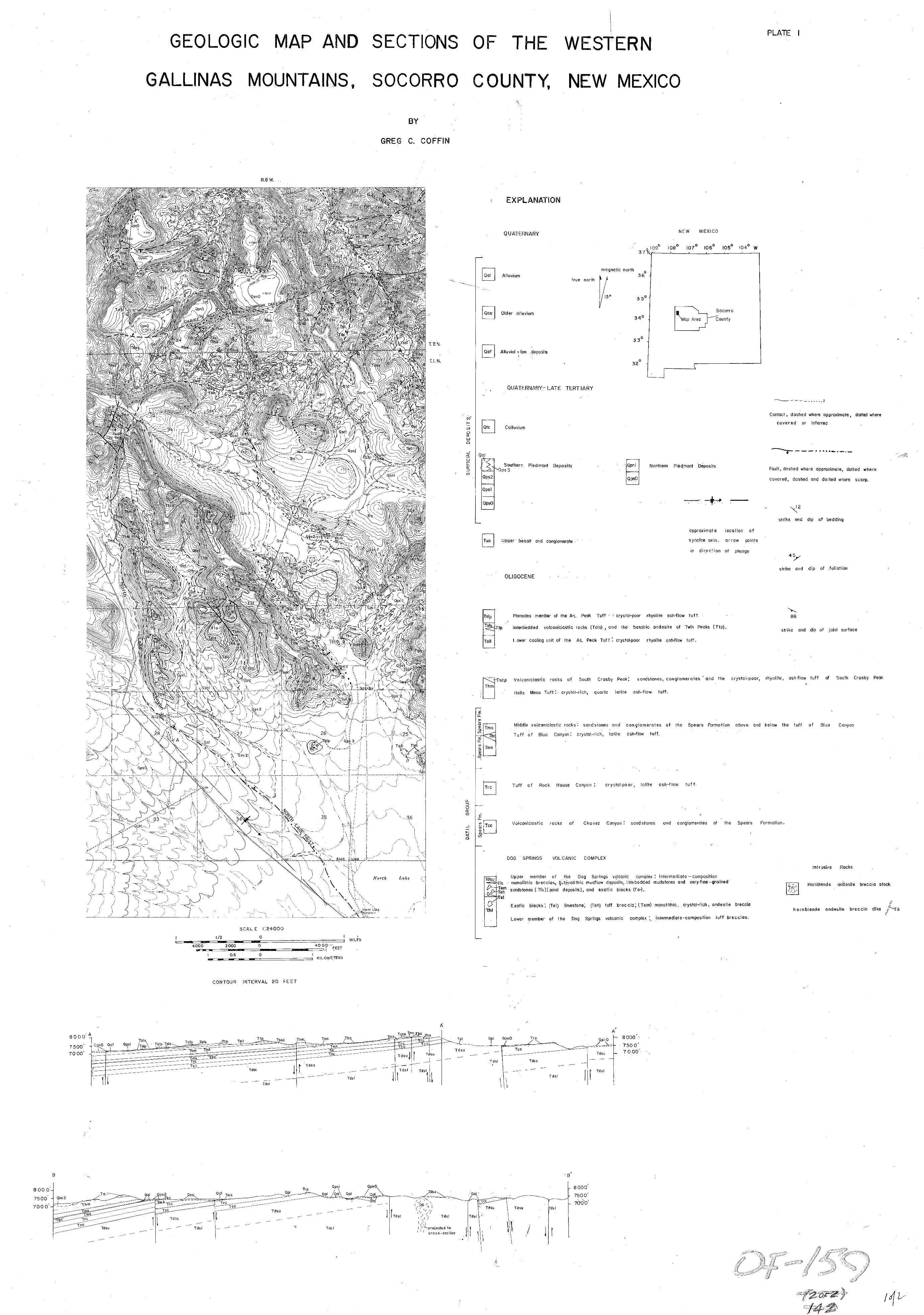
"
... ,.
-
I "I
', '!
" .o 0 0 t 0 000 2 oooc 5311111 ' I
""I ~~
0 z/ I I
-1 X31dW03 3lNY310A S9,NlUdS , 90Q
98 't
-.-.9 ..... L" L
J
IX 6

PLATE 2 . CORRELATION OF MAJOR ASH-FLOW SHEETS ALONG THE NORTHERN MARGIN OF THE SAN AUGUSTIN PLAINS
8
8 < *
CATRON COUNTY 1 SOCORRO COUNTY 9
ASH- F L O W TUFF
" Fl. CRYSTAL- RICH ASH-FLOW TUFF
I - 1
. . - VOLCANICLASTIC SEDIMENTARY
R O C K S .
3 \ 2 I 9
CROSBY MPS.
fl 1000'
A P P R O X I M A T E LOCATION OF STRATIGRAPHIC S E C T I O N S
2
- "
. . . . . . . . . . ' . . . . . . . . . . . . . . . . . . . . . . . . : ' . . . , . . - * ., . . * , .. *
\ -"
__&--"--a
SCALE IN FEET
S . CROSBY PEAK
W E L L S MESA
/
B L U E CANYON I 3LUE CANYON 1 .
3
NIPPLE M T . . . . . . .
D A T I L W E L
" -
ROCK HOUSE CANYON
/ U A T I L W E L L
(UPPER .MEMBER)
D O G S P R I N G S
V O L C A N I C C O M P L E X
S P E A R S FORMATION SPEARS FORMATIC S P E A R S *FORMATION
(LOWER MEMBER) SPEARS FORMATION
.BORNHORST BORNHORST
(1976)
L O P E Z
(1975)
HARRISON
( I 9 80)
THIS THESIS L A R O C H E
(1980)
CHAMBERLIN
(1974)
BROWN
( ~ I 9 72 )