open access enso impact on hydrology in peru discussions · w. s. lavado-casimiro et al.: enso...
TRANSCRIPT

Adv. Geosci., 33, 33–39, 2013www.adv-geosci.net/33/33/2013/doi:10.5194/adgeo-33-33-2013© Author(s) 2013. CC Attribution 3.0 License.
EGU Journal Logos (RGB)
Advances in Geosciences
Open A
ccess
Natural Hazards and Earth System
Sciences
Open A
ccess
Annales Geophysicae
Open A
ccess
Nonlinear Processes in Geophysics
Open A
ccess
Atmospheric Chemistry
and Physics
Open A
ccess
Atmospheric Chemistry
and Physics
Open A
ccess
Discussions
Atmospheric Measurement
Techniques
Open A
ccess
Atmospheric Measurement
Techniques
Open A
ccess
Discussions
Biogeosciences
Open A
ccess
Open A
ccess
BiogeosciencesDiscussions
Climate of the Past
Open A
ccess
Open A
ccess
Climate of the Past
Discussions
Earth System Dynamics
Open A
ccess
Open A
ccess
Earth System Dynamics
Discussions
GeoscientificInstrumentation
Methods andData Systems
Open A
ccess
GeoscientificInstrumentation
Methods andData Systems
Open A
ccess
Discussions
GeoscientificModel Development
Open A
ccess
Open A
ccess
GeoscientificModel Development
Discussions
Hydrology and Earth System
Sciences
Open A
ccess
Hydrology and Earth System
Sciences
Open A
ccess
Discussions
Ocean Science
Open A
ccess
Open A
ccess
Ocean ScienceDiscussions
Solid Earth
Open A
ccess
Open A
ccess
Solid EarthDiscussions
The Cryosphere
Open A
ccess
Open A
ccess
The CryosphereDiscussions
Natural Hazards and Earth System
Sciences
Open A
ccess
DiscussionsENSO impact on hydrology in Peru
W. S. Lavado-Casimiro1,2, O. Felipe1, E. Silvestre1, and L. Bourrel3
1Servicio Nacional de Meteorologıa e Hidrologıa, Lima, Peru2Universidad Nacional Agraria La Molina, Lima, Peru
Correspondence to:W. S. Lavado-Casimiro ([email protected])
Received: 18 May 2011 – Revised: 4 September 2011 – Accepted: 1 October 2012 – Published: 2 April 2013
Abstract. The El Nino and La Nina impacts on the hydrol-ogy of Peru were assessed based on discharge data (1968–2006) of 20 river catchments distributed over three drainageregions in Peru: 14 in the Pacific Coast (PC), 3 in the LakeTiticaca (TL) region, and 3 in the Amazonas (AM).
To classify the El Nino and La Nina events, we used theSouthern Oscillation Index (SOI) based on hydrologicalyears (September to August). Using the SOI values, theevents were re-classified as strong El Nino (SEN), moderateEl Nino (MEN), normal years (N), moderate La Nina (MLN)and strong La Nina (SLN).
On average during the SEN years, sharp increases occurredin the discharges in the north central area of the PC and de-creases in the remaining discharge stations that were ana-lyzed, while in the years of MEN events, these changes showdifferent responses than those of the SEN. During the yearsclassified as La Nina, positive changes are mostly observedin the majority of the stations in the rivers located in the cen-ter of Peru’s Pacific Coast. Another important result of thiswork is that the Ilave River (south of the Titicaca watershed)shows higher positive (negative) impacts during La Nina (ElNino) years, a fact that is not clearly seen in the rivers of thenorthern part of the Titicaca watershed (Ramis and Huancanerivers).
1 Introduction
Strong El Nino Southern Oscillation (ENSO) events like1982–1983 and 1997–1998 have induced the greatest im-pacts on the Peruvian economy as a result of the disasterscaused by the floods and droughts. Thus, according to OPS(2000), direct losses caused by ENSO extreme events during1997–1998 were estimated at US$ 1000 million, of which
800 million were estimated for the northern PC as a result ofheavy rains, and 200 million were estimated for the southernAndes region due to the effects of droughts. The economicimpact of these disasters was reflected in a significant reduc-tion of the gross domestic product (GDP) up to 12 %.
The ENSO phenomenon is a primary mode of seasonalclimatic variability, mainly in the tropics (Ropelewski andHalpert, 1987). The ENSO is a warming of the tropical Pa-cific Ocean and it has a great influence on weather patternsin several parts of the world.
In normal conditions, a mass of warm surface water ex-tends into the westernmost part of the tropical Pacific Ocean,while the ocean surface is cooler on the Ecuadorian andnorthern Peruvian coast. This distribution of water is causedby the east–westerly trade winds (that prevail in this part ofthe Ocean) running east to west and drag warm surface wa-ter westward. This shift allows surface water and cold deepwater to surface off the coast of South America (HumboldtCurrent). This current carries nutrients from the bottom; fishpopulations grow and form good fishing in this area. How-ever, with every cycle of this shift (∼ from 4 to 8 yr), the sys-tem of trade winds weakens while the mass of water is heated3 to 7◦C higher than normal. This phenomenon, which in-volves changes in the ocean and the atmosphere, is knownas El Nino, while contrary anomalies described above areknown as La Nina.
The impacts of the ENSO have been linked to hydro-climatic anomalies around the world. A complete analysisby Chiew and McMahon (2002) indicates a clear relation-ship between ENSO and river discharges: regionally signifi-cant and consistent teleconnections between ENSO and dis-charges are identified in Australia and New Zealand, Southand Central America, and moderately significant signals areidentified in parts of Africa and North America.
Published by Copernicus Publications on behalf of the European Geosciences Union.
34 W. S. Lavado-Casimiro et al.: ENSO impact on hydrology in Peru
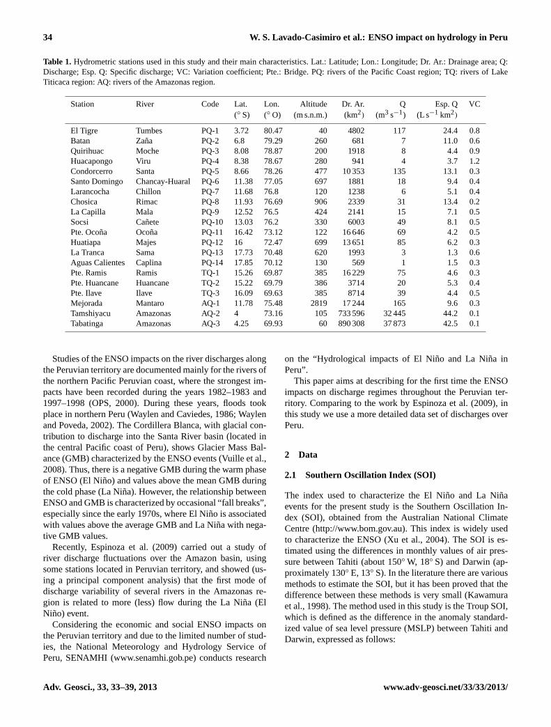
Table 1. Hydrometric stations used in this study and their main characteristics. Lat.: Latitude; Lon.: Longitude; Dr. Ar.: Drainage area; Q:Discharge; Esp. Q: Specific discharge; VC: Variation coefficient; Pte.: Bridge. PQ: rivers of the Pacific Coast region; TQ: rivers of LakeTiticaca region: AQ: rivers of the Amazonas region.
Station River Code Lat. Lon. Altitude Dr. Ar. Q Esp. Q VC(◦ S) (◦ O) (m s.n.m.) (km2) (m3 s−1) (L s−1 km2)
El Tigre Tumbes PQ-1 3.72 80.47 40 4802 117 24.4 0.8Batan Zana PQ-2 6.8 79.29 260 681 7 11.0 0.6Quirihuac Moche PQ-3 8.08 78.87 200 1918 8 4.4 0.9Huacapongo Viru PQ-4 8.38 78.67 280 941 4 3.7 1.2Condorcerro Santa PQ-5 8.66 78.26 477 10 353 135 13.1 0.3Santo Domingo Chancay-Huaral PQ-6 11.38 77.05 697 1881 18 9.4 0.4Larancocha Chillon PQ-7 11.68 76.8 120 1238 6 5.1 0.4Chosica Rimac PQ-8 11.93 76.69 906 2339 31 13.4 0.2La Capilla Mala PQ-9 12.52 76.5 424 2141 15 7.1 0.5Socsi Canete PQ-10 13.03 76.2 330 6003 49 8.1 0.5Pte. Ocona Ocona PQ-11 16.42 73.12 122 16 646 69 4.2 0.5Huatiapa Majes PQ-12 16 72.47 699 13 651 85 6.2 0.3La Tranca Sama PQ-13 17.73 70.48 620 1993 3 1.3 0.6Aguas Calientes Caplina PQ-14 17.85 70.12 130 569 1 1.5 0.3Pte. Ramis Ramis TQ-1 15.26 69.87 385 16 229 75 4.6 0.3Pte. Huancane Huancane TQ-2 15.22 69.79 386 3714 20 5.3 0.4Pte. Ilave Ilave TQ-3 16.09 69.63 385 8714 39 4.4 0.5Mejorada Mantaro AQ-1 11.78 75.48 2819 17 244 165 9.6 0.3Tamshiyacu Amazonas AQ-2 4 73.16 105 733 596 32 445 44.2 0.1Tabatinga Amazonas AQ-3 4.25 69.93 60 890 308 37 873 42.5 0.1
Studies of the ENSO impacts on the river discharges alongthe Peruvian territory are documented mainly for the rivers ofthe northern Pacific Peruvian coast, where the strongest im-pacts have been recorded during the years 1982–1983 and1997–1998 (OPS, 2000). During these years, floods tookplace in northern Peru (Waylen and Caviedes, 1986; Waylenand Poveda, 2002). The Cordillera Blanca, with glacial con-tribution to discharge into the Santa River basin (located inthe central Pacific coast of Peru), shows Glacier Mass Bal-ance (GMB) characterized by the ENSO events (Vuille et al.,2008). Thus, there is a negative GMB during the warm phaseof ENSO (El Nino) and values above the mean GMB duringthe cold phase (La Nina). However, the relationship betweenENSO and GMB is characterized by occasional “fall breaks”,especially since the early 1970s, where El Nino is associatedwith values above the average GMB and La Nina with nega-tive GMB values.
Recently, Espinoza et al. (2009) carried out a study ofriver discharge fluctuations over the Amazon basin, usingsome stations located in Peruvian territory, and showed (us-ing a principal component analysis) that the first mode ofdischarge variability of several rivers in the Amazonas re-gion is related to more (less) flow during the La Nina (ElNino) event.
Considering the economic and social ENSO impacts onthe Peruvian territory and due to the limited number of stud-ies, the National Meteorology and Hydrology Service ofPeru, SENAMHI (www.senamhi.gob.pe) conducts research
on the “Hydrological impacts of El Nino and La Nina inPeru”.
This paper aims at describing for the first time the ENSOimpacts on discharge regimes throughout the Peruvian ter-ritory. Comparing to the work by Espinoza et al. (2009), inthis study we use a more detailed data set of discharges overPeru.
2 Data
2.1 Southern Oscillation Index (SOI)
The index used to characterize the El Nino and La Ninaevents for the present study is the Southern Oscillation In-dex (SOI), obtained from the Australian National ClimateCentre (http://www.bom.gov.au). This index is widely usedto characterize the ENSO (Xu et al., 2004). The SOI is es-timated using the differences in monthly values of air pres-sure between Tahiti (about 150◦ W, 18◦ S) and Darwin (ap-proximately 130◦ E, 13◦ S). In the literature there are variousmethods to estimate the SOI, but it has been proved that thedifference between these methods is very small (Kawamuraet al., 1998). The method used in this study is the Troup SOI,which is defined as the difference in the anomaly standard-ized value of sea level pressure (MSLP) between Tahiti andDarwin, expressed as follows:
Adv. Geosci., 33, 33–39, 2013 www.adv-geosci.net/33/33/2013/
W. S. Lavado-Casimiro et al.: ENSO impact on hydrology in Peru 35
SOI= ×DMSLP− DMSLP
SMSLP, (1)
whereDMSLP is the difference between the monthly averageMSLP in Tahiti and Darwin,DMSLP is the mean value ofDMSLP, andSMSLP is the standard deviation ofDMSLP forthe 1968–2005 period.
2.2 Discharges
Watersheds across the Peruvian territory are distinguisheddue to the presence of the Andes Cordillera. The rivers thatdrain into the Pacific Ocean are characterized by steep slopes,they are not very long, and their rainfall and discharge peaksoccur simultaneously. The rivers that flow into the AmazonRiver are characterized by steep slopes in the Andes andnear-zero slopes in the Amazon lowlands, where they havelarge drainage areas. The rainfall peaks occur two monthsbefore the discharge peaks in the Amazon plains and simulta-neously in the Andes, which depend on the catchments size.The Titicaca endorheic drainage is characterized by meanslopes, and because it is located in the highlands, the averageresponse between rainfall and discharge peaks is one month.
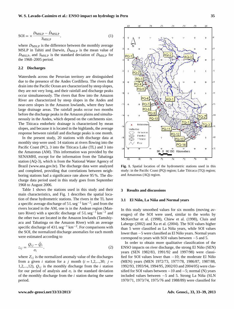
In the present study, 20 stations with discharge data atmonthly step were used: 14 stations at rivers flowing into thePacific Coast (PC), 3 into the Titicaca Lake (TL) and 3 intothe Amazonas (AM). This information was provided by theSENAMHI, except for the information from the Tabatingastation (AQ-3), which is from the National Water Agency ofBrazil (www.ana.gov.br). The discharge data were analyzedand completed, providing that correlations between neigh-boring stations had a significance rate above 95 %. The dis-charge data period used in this study goes from September1968 to August 2006.
Table 1 shows the stations used in this study and theirmain characteristics, and Fig. 1 describes the spatial loca-tion of these hydrometric stations. The rivers in the TL havea specific average discharge of 5 L seg−1 km−2; and from therivers located in the AM, one is in the Andean region (Man-taro River) with a specific discharge of 5 L seg−1 km−2 andthe other two are located in the Amazon lowlands (Tamshiy-acu and Tabatinga on the Amazon River) with an averagespecific discharge of 43 L seg−1 km−2. For comparisons withthe SOI, the normalized discharge anomalies for each monthwere estimated according to
zij =Qij − Qi
σi
, (2)
whereZij is the normalized anomaly value of the dischargesfrom a given i station for aj month (i = 1,2,...,30;j =
1,2,...,12),Qij is the monthly discharge from thei stationfor our period of analysis andσi is the standard deviationof the monthly discharge from thei station during the sameperiod.
1
1
2
Figure 1. Spatial location of the hydrometric stations used in this study: in the Pacific 3
Coast (PQs); Titicaca Lake (TQs) and Amazonas (AQs). 4
5
6
Fig. 1. Spatial location of the hydrometric stations used in thisstudy: in the Pacific Coast (PQ) region; Lake Titicaca (TQ) region;and Amazonas (AQ) region.
3 Results and discussions
3.1 El Nino, La Nina and Normal years
In this study smoothed values for six months (moving av-erages) of the SOI were used, similar to the works byMcKerchar et al. (1998), Chiew et al. (1998), Cluis andLaberge (2002) and Xu et al. (2004). The SOI values higherthan 5 were classified as La Nina years, while SOI valueslower than−5 were classified as El Nino years. Normal yearscorrespond to years with SOI values between−5 and 5.
In order to obtain more qualitative classification of theENSO impacts on river discharge, the strong El Nino (SEN)years (SEN 1982/83, 1991/92 and 1997/98) were classi-fied for SOI values lower than−10; the moderate El Nino(MEN) years (MEN 1972/73, 1977/78, 1986/87, 1987/88,1992/93, 1993/94, 1994/95, 2002/03 and 2004/05) were clas-sified for SOI values between−10 and−5; normal (N) yearsincluded values between−5 and 5. Strong La Nina (SLN1970/71, 1973/74, 1975/76 and 1988/89) were classified for
www.adv-geosci.net/33/33/2013/ Adv. Geosci., 33, 33–39, 2013

36 W. S. Lavado-Casimiro et al.: ENSO impact on hydrology in Peru
Table 2.Monthly statistical values for the discharges during the different periods: St.: Stations; Aver.: Average; VC: Variations Coefficient.
St. Historical SEN MEN N SLN MLN
Aver. VC Aver. VC Aver. VC Aver. VC Aver. VC Aver. VC
PQ-1 120 1.4 314 1.1 112 1.3 86 1.2 127 1.2 129 1.1PQ-2 7 1.3 17 1.5 6 0.9 6 1.0 8 0.8 10 0.8PQ-3 8 1.9 21 2.0 7 1.4 6 1.6 8 1.3 14 1.4PQ-4 4 2.8 11 2.4 2 1.6 3 2.6 3 1.7 4 2.1PQ-5 136 0.9 158 0.9 141 0.9 125 0.9 144 0.9 148 0.9PQ-6 18 1.2 20 1.2 15 1.0 18 1.3 18 0.9 19 1.2PQ-7 6 1.0 5 1.0 6 0.9 6 1.0 5 1.1 9 0.9PQ-8 31 0.6 28 0.6 32 0.6 31 0.6 27 0.6 38 0.6PQ-9 15 1.4 11 1.5 15 1.3 14 1.5 21 1.4 18 1.3PQ-10 49 1.3 45 1.1 46 1.1 51 1.4 47 1.1 51 1.0PQ-11 69 1.2 40 1.4 61 1.1 66 1.3 89 1.2 102 1.2PQ-12 85 1.1 64 1.0 81 1.1 80 1.0 105 1.1 107 1.1PQ-13 3 1.8 1 2.1 2 1.4 2 1.8 3 1.6 5 1.6PQ-14 1 0.9 1 1.4 1 0.5 1 0.7 1 0.8 1 1.0TQ-1 75 1.2 44 1.1 79 1.1 74 1.2 86 1.3 82 1.2TQ-2 20 1.4 12 1.1 21 1.2 20 1.4 22 1.6 19 1.5TQ-3 39 1.6 10 1.0 30 1.5 41 1.5 50 1.6 55 1.7AQ-1 165 0.8 119 0.6 170 0.8 163 0.8 196 0.8 186 0.8AQ-2 32 434 0.4 29 608 0.4 33 055 0.3 31 795 0.4 35 673 0.4 32 621 0.4AQ-3 37 864 0.3 35 112 0.3 38 428 0.3 37 208 0.3 40 693 0.3 38 605 0.3
SOI values higher than 10 and moderate La Nina (MLN)years (MLN 1974/75, 1998/99, 1999/00 and 2000/01) forvalues between 5 and 10.
3.2 Impacts on discharge during the El Nino,La Ni na and normal (N) years
3.2.1 Impacts on the mean statistics
Table 2 shows mean characteristics of monthly discharges forthe whole historical series and for the SEN, MEN, N, SLNand MLN years. Figure 2 shows a spatial representation ofthe results. The main results can be described by event asfollows:
– During SEN years, strong floods are clearly observed,especially in the rivers of the northern Pacific coast(PQ-1 to PQ-6), with changes of up to approximately+200 % in PQ-4; the rivers of the central and south Pa-cific (PQ-7 to PQ-14) as well as the rivers in the Tit-icaca and Amazon watershed show a decrease in theirdischarge during SEN years; the largest decrease oc-curred in TQ-3 with up to−75 % and the smallest de-crease occurred in AQ-2 and AQ-3, consistent with pre-vious studies (i.e. Aceituno and Montecinos (1993) inthe highlands; Marengo et al. (1998) in the northern Pa-cific; and Espinoza et al. (2009) in the Amazon basin).
– During MEN years, several responses can be evidenced;in the PC, negative anomalies of the mean rates areobserved in the rivers of the northern (PQ-1 to PQ-4)
up to −30 % in PQ-4, as well as for the rivers PQ-6,PQ-9 to PQ-14 and TQ-3. For the later, the anomalyreaches−20 %. The PQ-5, PQ-7, PQ-8, TQ-1, TQ-2rivers and the three rivers located in the AM show pos-itive changes, but with values that do not exceed+5 %change rate.
– During SLN and MLN years, some positive changesare observed in their mean values in all the rivers thatwere analyzed; the changes were more pronounced dur-ing MLN years with values of+66 % in PQ-3,+47 inPQ-11,+88 % in PQ-13 and+41 % in TQ-3 (Table 2).
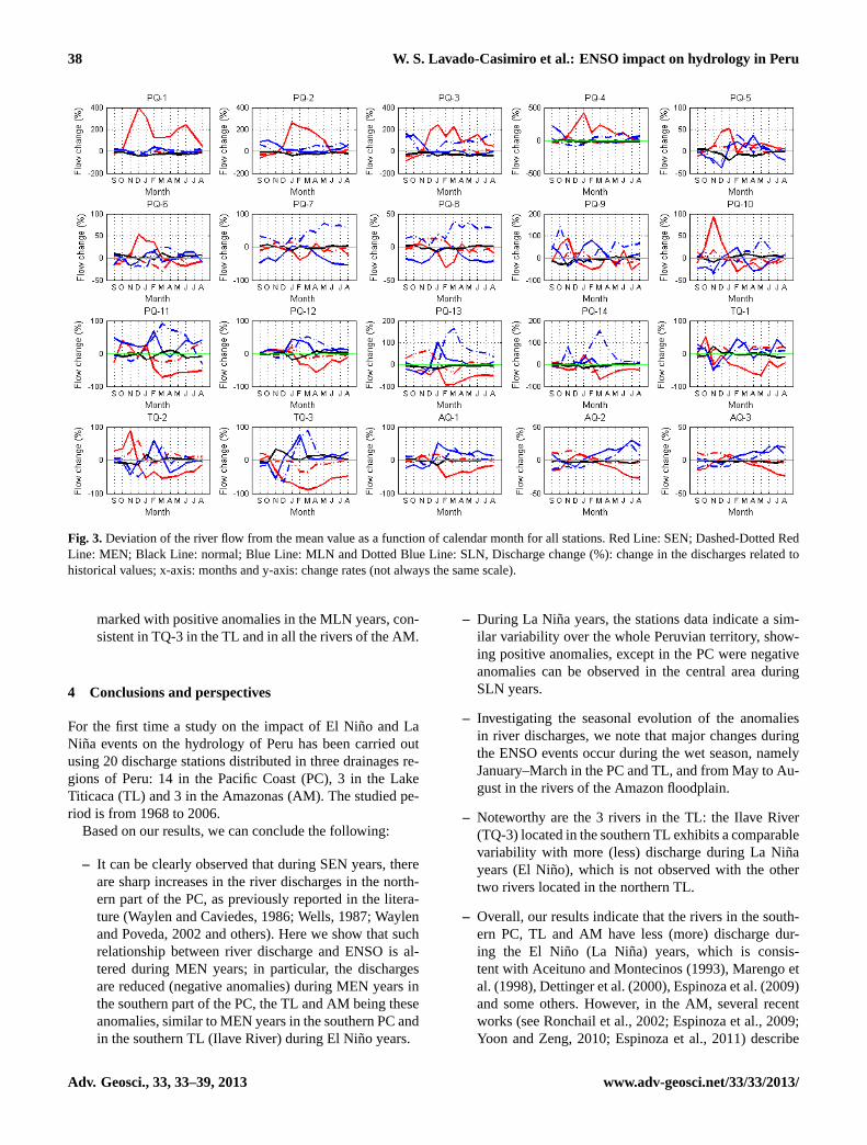
3.2.2 Impacts on monthly discharges
The behavior of the monthly historical average discharge inthe analyzed stations showed unimodal characteristics witha period for maximum overflow in the months of Februaryand March in all the stations except for the stations locatedin the Amazon Plains (AQ-2 and AQ-3), in which maximumoverflow occurred in April and May.
Using the same methodology as in the previous section,we present in Fig. 3 the changes during the El Nino years(SEN and MEN), normal (N) years and La Nina years (SLNand MLN). In this figure, we can observe that
– During SEN years, the same rivers which present thelargest positive changes in their mean value (PQ-1 toPQ-6, see above section) show the greatest changes forthe months of December and January, reaching an in-crease of more than 400 % in PQ-4. From PQ-1 to PQ-4,
Adv. Geosci., 33, 33–39, 2013 www.adv-geosci.net/33/33/2013/

W. S. Lavado-Casimiro et al.: ENSO impact on hydrology in Peru 37
2
1
Figure 2. Spatial distribution of rate changes in mean discharges in relation to the historical 2
series for the different events in all the stations. The Strong El Niño years (SEN), the 3
Moderate El Niño years (MEN), the Strong La Niña years (SLN) and the Moderate La 4
Niña years (MLN). 5
6
7
Fig. 2.Spatial distribution of rate changes in mean discharges in relation to the historical series for the different events in all the stations. TheStrong El Nino years (SEN), the Moderate El Nino years (MEN), the Strong La Nina years (SLN) and the Moderate La Nina years (MLN).
positive changes were constant from December to May.The other rivers of the PC, the TL and the AM mostlyshow negative changes during the SEN events; thus, thelargest negative changes occurred during the months ofFebruary and March, except for the rivers located inthe Amazon Plain (AQ-2 and AQ-3), which showed thegreatest changes in August. Among these rivers, PQ-13(February) and TQ-3 (March) are the ones that showedthe major negative changes,−93 % and−89 %, respec-tively.
– During MEN years, the rivers that show greater pos-itive changes in SEN years in their monthly values(December-May) (e.g. PQ-1 and PQ-4) show negativechanges during these months, reaching−57 % in Marchin PQ-4. The same behavior was observed in other an-
alyzed stations, i.e. negative changes during the MENevents. In short, during the El Nino events (SEN andMEN), it is observed that the SEN years had the greatestpositive changes/anomalies for the rivers of the northernpart of the PC, while all the other rivers exhibited neg-ative anomalies in their discharge rate. The more im-portant changes take place in the southern part of thePC (with PQ-13 Sama River as the most intense) andin the TL (with TQ-3 Ilave River as the most intense),while the MEN years are characterized by mostly nega-tive changes in all the analyzed rivers.
– During the SLN and the MLN, similar behaviors are ob-served (see Fig. 3). La Nina years are characterized byshowing mostly positive changes in the river dischargein Peru. They occurred mainly during flood periods
www.adv-geosci.net/33/33/2013/ Adv. Geosci., 33, 33–39, 2013
38 W. S. Lavado-Casimiro et al.: ENSO impact on hydrology in Peru
3
1
2
3
4
Figure 3. Deviation of the river flow from the mean value as a function of calendar month 5
for all stations. Red Line: SEN; Dashed-Dotted Red Line: MEN; Black Line: Normal; Blue 6
Line: MLN and Dotted Blue Line: SLN, Discharge change (%): Change in the discharges 7
related to historical values; X axis: months and Y axis: change rates (not always the same 8
scale). 9
10
11
12
13
14
15
16
17
18
Fig. 3. Deviation of the river flow from the mean value as a function of calendar month for all stations. Red Line: SEN; Dashed-Dotted RedLine: MEN; Black Line: normal; Blue Line: MLN and Dotted Blue Line: SLN, Discharge change (%): change in the discharges related tohistorical values; x-axis: months and y-axis: change rates (not always the same scale).
marked with positive anomalies in the MLN years, con-sistent in TQ-3 in the TL and in all the rivers of the AM.
4 Conclusions and perspectives
For the first time a study on the impact of El Nino and LaNina events on the hydrology of Peru has been carried outusing 20 discharge stations distributed in three drainages re-gions of Peru: 14 in the Pacific Coast (PC), 3 in the LakeTiticaca (TL) and 3 in the Amazonas (AM). The studied pe-riod is from 1968 to 2006.
Based on our results, we can conclude the following:
– It can be clearly observed that during SEN years, thereare sharp increases in the river discharges in the north-ern part of the PC, as previously reported in the litera-ture (Waylen and Caviedes, 1986; Wells, 1987; Waylenand Poveda, 2002 and others). Here we show that suchrelationship between river discharge and ENSO is al-tered during MEN years; in particular, the dischargesare reduced (negative anomalies) during MEN years inthe southern part of the PC, the TL and AM being theseanomalies, similar to MEN years in the southern PC andin the southern TL (Ilave River) during El Nino years.
– During La Nina years, the stations data indicate a sim-ilar variability over the whole Peruvian territory, show-ing positive anomalies, except in the PC were negativeanomalies can be observed in the central area duringSLN years.
– Investigating the seasonal evolution of the anomaliesin river discharges, we note that major changes duringthe ENSO events occur during the wet season, namelyJanuary–March in the PC and TL, and from May to Au-gust in the rivers of the Amazon floodplain.
– Noteworthy are the 3 rivers in the TL: the Ilave River(TQ-3) located in the southern TL exhibits a comparablevariability with more (less) discharge during La Ninayears (El Nino), which is not observed with the othertwo rivers located in the northern TL.
– Overall, our results indicate that the rivers in the south-ern PC, TL and AM have less (more) discharge dur-ing the El Nino (La Nina) years, which is consis-tent with Aceituno and Montecinos (1993), Marengo etal. (1998), Dettinger et al. (2000), Espinoza et al. (2009)and some others. However, in the AM, several recentworks (see Ronchail et al., 2002; Espinoza et al., 2009;Yoon and Zeng, 2010; Espinoza et al., 2011) describe
Adv. Geosci., 33, 33–39, 2013 www.adv-geosci.net/33/33/2013/
W. S. Lavado-Casimiro et al.: ENSO impact on hydrology in Peru 39
the strong influence of tropical North Atlantic SST onhydrology into the western Amazon Basin. Thus, whiletropical North Atlantic SST is warmer than usual, lessrainfall and discharge is noticed in the western Amazonduring austral winter and spring. For this reason, a fur-ther study on this topic taking into account the ENSOand the Atlantic influences will be undertaken in the fu-ture.
Acknowledgements.This work was conducted with funding fromthe SENAMHI (Ministry of Environment). Special thanks to JhanCarlo Espinoza for his contributions in improving this documentand also to Ana Gropuzzo by the translation of this article. Also,thanks to two anonymous reviewers for help to improve this paper.
References
Aceituno, P. and Montecinos, A.: Analisis de la estabilidad de larelacion entre la oscilacion del Sur y la precipitacion en Americadel Sur, Bull. Inst. Fr.etudes Andines, 22, 53–64, 1993.
Chiew, F., Piechota, T., Dracup, J., and McMahon, T.: ElNino/Southern Oscillation and Australian rainfall, streamflowand drought: Links and potential for forecasting, J. Hydrol., 204,138–149, 1998.
Chiew, F. H. S. and McMahon, T. A.: Global ENSO-streamflowteleconnection, streamflow forecasting and interannual variabil-ity, Hydrolog. Sci. J., 47, 505–522, 2002.
Cluis, D. and Laberge, C.: Analysis of the El Nino effect on thedischarge of selected rivers in the Asia-Pacific region, Water Int.,27, 279–293, 2002.
Dettinger, M. D., Cayan, D. R., McCabe, G. M., and Marengo,J. A.: Multiscale streamflow variability associated with ElNino/Southern Oscillation, in: El Nino and the SouthernOscillation-Multiscale Variability and Global and Regional Im-pacts, edited by: Diaz, H. F. and Markgraf, V., Cambridge Uni-versity Press, 113–146, 2000.
Espinoza, J. C., Guyot, J. L., Ronchail, J., Cochonneau, G., Filizola,N., Fraizy, P., Labat, D., Noriega, L., Oliveira, E., Ordonez, J.J., and Vauchel, P.: Contrasting regional discharge evolutions inthe Amazon basin (1974–2004): Contrasting regional dischargeevolution in the Amazon Basin, J. Hydrol., 375, 297–311, 2009.
Espinoza, J. C., Ronchail, J., Guyot, J. L., Junquas, C., Vauchel, P.,Lavado, W. S., Drapeau, G., and Pombosa, R.: Climate variabil-ity and extremes drought in the upper Solimoes River (WesternAmazon Basin): Understanding the exceptional 2010 drought,Geophys. Res. Lett., 38, L13406, doi:10.1029/2011GL047862,2011.
Kawamura, A., McKerchar, A., Spigel, R., and Jinno, K.: Chaoticcharacteristics of the Southern Oscillation Index time series, J.Hydrol., 204, 168–181, 1998.
Marengo, J. A., Tomsella, J., and Uvo, C. R.: Long-term streamflowand rainfall fluctuations in tropical South America: Amazonia,East Brazil, and Northwest Peru, J. Geophys. Res., 103, 1775–1783, 1998.
McKerchar, A., Pearson, C., and Fitzharris, B.: Dependency of sum-mer lake inflows and precipitation on spring SOI, J. Hydrol., 205,66–80, 1998.
OPS: Peru: Fenomeno El Nino, 1997–1998, Organizacion Panamer-icana de la Salud, Fenomeno El Nino, 1997–1998, WashigtonD.C., 2000.
Ronchail, J., Cochonneau, G., Molinier, M., Guyot, J. L., Goretti deMiranda Chaves, A., Guimaraes, V., and de Oliveira, E.: Rainfallvariability in the Amazon Basin and SSTs in the tropical Pacificand Atlantic oceans, Int. J. Climatol., 22, 1663–1686, 2002.
Ropelewski, C. F. and Halpert, M. S.: Global and Regional ScalePrecipitation Patterns Associated with the El-Nino Southern Os-cillation, Mon. Weather Rev., 115, 1606–1626, 1987.
Vuille, M., Kaser, G., and Juen, I.: Glacier mass balance variabilityin the Cordillera Blanca, Peru and its relation with climate andlarge-scale circulation, Global Planet. Change, 62, 14–28, 2008.
Waylen, P. R. and Caviedes, C. N.: El Nino and annual floods on thenorth Peruvian littoral, J. Hydrol., 89, 141–156, 1986.
Waylen, P. and Poveda, G.: El Nino southern oscillation and aspectsof western South American hydroclimatology, Hydrol. Process.,16, 1247–1260, 2002.
Wells, L. E.: An alluvial record of El-Nino events from northerncoastal Peru, J. Geophys. Res.-Oceans, 92, 14463–14470, 1987.
Xu, Z. X., Takeuchi, K., and Ishidaira, H.: Correlation between ElNino-Southern Oscillation (ENSO) and precipitation in South-east Asia and the Pacific region, Hydrol. Process., 18, 107–123,2004.
Yoon, J. H. and Zeng, H.: An Atlantic influence on Amazon rainfall,Clim. Dynam., 34, 249–264, 2010.
www.adv-geosci.net/33/33/2013/ Adv. Geosci., 33, 33–39, 2013