oooo#.l.a(j~ooo ~oooooo · council assessment panel 3 april 2019 5. the monopole headframe is to...
TRANSCRIPT

Adelaide Plains Council
Council Assessment Panel
NOTICE OF MEETING
Notice is hereby given in accordance with Section 83 of the PlanningJ Development and Infrastructure Act 2016,
that a meeting of the
Adelaide Plains Council Assessment Panel
will be held in the
Council Chamber Old Port Wakefield Road Two Wells
on
Wednesday, 1 May 2019 at 5.30 pm
OOOO#.l.A(J~OOO ~OOOOOO O O O O O H 0 0 0 000
Robert Veitch General M anager Development and Community

AGENDA
1. ATTENDANCE
1.1. Present
1.2. Apologies
1.3. Not Present / Leave of Absence
2. CONFIRMATION OF MINUTES
2.1. “that the minutes of the Council Assessment Panel meeting held on Wednesday 3 April 2019, be accepted as read and confirmed.”
3. DECLARATION OF INTEREST
4. REPORTS FOR DECISION
4.1. Category 1 Development ‐ Nil
4.2. Category 2 Development ‐ Nil
4.3. Category 3 Development ‐ Nil
4.4. Other ‐ Nil
5. REPORTS FOR INFORMATION
6. OTHER BUSINESS
7. CONFIDENTIAL ITEMS
7.1. 312/314/2016 – Andrew Gameau – Construction of a domestic outbuilding and associated earthworks – Lot 235, 2 Magnolia Boulevard, Two Wells
7.2. 312/65/2017 – Alex Lange – Construction of a domestic outbuilding and associated earthworks – Lot 233, 6 Magnolia Boulevard, Two Wells
8. NEXT MEETING
Wednesday 5 June 2019 (To be confirmed)
9. CLOSURE

Council Assessment Panel
3 April 2019
MINUTES
of
Council Assessment Panel Meeting
Pursuant to the provisions of section 83 of the
Planning, Development and Infrastructure Act 2016
HELD IN
Council Chambers Redbanks Road,
Mallala
on
Wednesday, 3 April 2019 at 5:30pm
Council Assessment Panel Page 3 of 138 1 May 2019Council Assessment Panel Page 3 of 138 1 May 2019
Council Assessment Panel
3 April 2019
The Presiding Member formally declared the meeting open at 5:30pm.
1. ATTENDANCE RECORD
1.1. Present
Nathan Cunningham (Presiding Member) Ian O’Loan Chris Carrey Cherry Getsom Frank Maiolo (Council Member)
Also in Attendance
Brendon Schulz (Development Services Coordinator) Anthony Zollo (Planning Officer) George Jacks (Graduate Planner) Carol Wildbore (Minute Secretary)
1.2. Apologies
1.3. Not Present / Leave of Absence
2. CONFIRMATION OF MINUTES
2.1.
Moved F Maiolo Seconded I O’Loan
“that the minutes of the Council Assessment Panel meeting held on Wednesday 5 Dcember2018, be accepted as read and confirmed.”
Agreed
3. DECLARATION OF INTEREST
It was noted that Presiding Member Nathan Cunningham received advice from Independent Member Cherry Getsom who was employed by Aurecon approximately 8 years ago. Aurecon are involved as the applicant in item 4.3.1. Through discussions with Cherry it can be confirmed that there is no true conflict of interest as there is no ongoing relationship of any kind in a work sense. Therefore there are no Declarations of Interest.
Council Assessment Panel Page 4 of 138 1 May 2019Council Assessment Panel Page 4 of 138 1 May 2019

Council Assessment Panel
3 April 2019
4. REPORTS FOR DECISION
4.1. Category 1 Development
4.1.1. Nil
4.2. Category 2 Development
4.2.1. Nil
4.3. Category 3 Development
4.3.1. 312/372/2018 – Aurecon on behalf of NBN Co Limited – Fixed wireless telecommunications facility comprising a 30 metre high monopole, antennas and associated infrastructure – Lot 248, Ruskin Road, Thompson Beach
Kate Croucher (Aurecon Australia), spoke on behalf of the applicant.
Moved I O’Loan Seconded C Carrey
1. That the Council Assessment Panel resolves that the proposal by Aurecon on behalf of NBN Co for the construction of a fixed wireless telecommunications facility comprising a 30 metre high monopole, antennas and associated infrastructure at Lot 248 Ruskin Road Thompson Beach, (312/372/2018) is not seriously at variance with the Mallala Council Development Plan consolidated 20 February 2018.
2. That the Council Assessment Panel resolves that the proposal by Aurecon on behalf
of NBN Co for the construction of a fixed wireless telecommunications facility
comprising a 30 metre high monopole, antennas and associated infrastructure at
Lot 248 Ruskin Road Thompson Beach, (312/372/2018) be GRANTED Development
Plan Consent, pursuant to Section 33(1)(a) of the Development Act 1993, subject to
the following conditions being imposed:-
1. The development must be undertaken, completed and maintained in accordance
with the details, plans, specifications and correspondence submitted with and
forming part of Development Application 312/372/2018, except where varied by
any conditions listed below.
2. Existing vegetation within the subject land not directly affected by the site and
building work must be retained and protected during the development to the
reasonable satisfaction of Council and the Native Vegetation Council.
3. No lighting or sound is to be emitted from any devices associated with the
development on the subject site, so as to impinge upon the enjoyment of adjoining
and adjacent properties by the occupiers thereof.
4. Compound fencing must be of an open mesh construction to a maximum height of
2.4 metres above natural ground level.
Council Assessment Panel Page 5 of 138 1 May 2019Council Assessment Panel Page 5 of 138 1 May 2019

Council Assessment Panel
3 April 2019
5. The monopole headframe is to have bird proofing measures installed at the time of
construction to reduce the risk of nesting.
6. Any mechanical and electrical equipment vulnerable to water ingress should be
made safe from coastal flooding risk and therefore be protected and/or raised to a
minimum recommended level of 3.35 metres Australian Height Datum.
7. Excavation and construction shall be carried out in a manner which minimises
environmental impacts on coastal landform.
8. Stormwater must be discharged and managed in a manner that does not result in
ponding or adverse effect to surrounding buildings or adjoining properties
Notes
1. This is not a building consent, and a Building Rules Consent is required to be
submitted to Council before a Development Approval can be issued. The approved
plans have been stamped ‘Development Plan Consent’ and should be forwarded to
any Private Certifier engaged for the Building Rules Assessment of this application.
2. The land over which the development is situated may have the potential to develop
acid sulfate conditions if exposed to oxygen. Spoil material should be closely
monitored and tested for potential coastal acid sulfate soils and a contingency plan
to remediate this action should be put in place, via an appropriate soil expert. The
Coast Protection Board has released a set of guidelines which should be followed in
areas where acid sulfate soils are likely to occur. These can be found at:
http://www.environment.sa.gov.au/about-us/boards-and-committees/Coast_Protection_Board/Coastal_acid_sulfate_soils
3. A portion of the subject site contains native vegetation. There may be requirements
regarding the clearance of native vegetation under the Native Vegetation Act 1991,
in which case the applicant should be made aware of these requirements.
4. The applicant is reminded of their general environmental duty, as required by Section
25 of the Environment Protection Act, to take all reasonable and practical measures
to ensure that the activities on the whole site, including during construction, do not
cause environmental harm.
Agreed
Council Assessment Panel Page 6 of 138 1 May 2019Council Assessment Panel Page 6 of 138 1 May 2019

Council Assessment Panel
3 April 2019
4.3.2. 312/235/2018 – Visionstream on behalf of Telstra – Construction of telecommunications facility comprising 41.3 metre tall monopole, triangular head frame, antennae, twin mounted amplifiers, equipment shelter and a 2.4 metre tall mesh security fence with access gate – Section 403 Driscoll Terrace, Parham
Representor Alvin Jenkin addressed the Panel.
Stefan Kaldis (Visionstream), spoke on behalf of the applicant.
Moved C Getsom Seconded F Maiolo
1. That the Council Assessment Panel resolves that the proposal by Visionstream on
behalf of Telstra for the construction of a telecommunications facility comprising
41.3 metre tall monopole, triangular head frame, antennae, twin mounted
amplifiers, equipment shelter and a 2.4 metre tall mesh security fence with access
gate at Section 403 Driscoll Terrace Parham, (312/235/2018) is not seriously at
variance with the Mallala Council Development Plan consolidated 20 February
2018.
2. That the Council Assessment Panel resolves that the proposal by Visionstream on
behalf of Telstra for the construction of a telecommunications facility comprising
41.3 metre tall monopole, triangular head frame, antennae, twin mounted
amplifiers, equipment shelter and a 2.4 metre tall mesh security fence with access
gate at Section 403 Driscoll Terrace Parham, (312/235/2018) be GRANTED
Development Plan Consent, pursuant to Section 33(1)(a) of the Development Act
1993, subject to the following conditions being imposed:-
1. The development must be undertaken, completed and maintained in
accordance with the details, plans, specifications and correspondence
submitted with and forming part of Development Application 312/235/2018,
except where varied by any conditions listed below.
2. The development site must have safe and convenient vehicle access to Port
Parham Road, designed, constructed and located to the satisfaction of Council’s
Depot Operations Coordinator.
3. The external walls and roof of the equipment shelter must be of subdued
colours which complement the predominant colours of the land and vegetation
in the locality and must be maintained in good appearance and condition at all
times.
4. Existing vegetation within the subject land not directly affected by the site and
building work must be retained and protected during the development to the
reasonable satisfaction of Council.
5. No lighting or sound is to be emitted from any devices associated with the
development on the subject site, so as to impinge upon the enjoyment of
adjoining and adjacent properties by the occupiers thereof.
Council Assessment Panel Page 7 of 138 1 May 2019Council Assessment Panel Page 7 of 138 1 May 2019

Council Assessment Panel
3 April 2019
6. Fencing must be of an open mesh construction
7. Any mechanical and electrical equipment vulnerable to water ingress should be
made safe from coastal flooding risk and therefore be protected and/or raised
to a minimum recommended level of 3.40 metres Australian Height Datum.
8. Excavation and construction must be carried out in a manner which minimises
environmental impacts on coastal landform.
9. Stormwater must be discharged and managed in a manner that does not result
in ponding or adverse effect to surrounding buildings or adjoining properties
Notes 1. This is not a building consent, and a Building Rules Consent is required to be
submitted to Council before a Development Approval can be issued.
2. The approved plans have been stamped ‘Development Plan Consent’ and
should be forwarded to any Private Certifier engaged for the Building Rules
Assessment of this application.
3. The applicant is reminded of their general environmental duty, as required by
Section 25 of the Environment Protection Act, to take all reasonable and
practical measures to ensure that the activities on the whole site, including
during construction, do not cause environmental harm.
4. The development site is to be kept constrained to the area identified in Figure
6 of the relevant site plan wherever practical, and vehicles are to keep to
existing tracks and the main site access track that is to be created.
5. Any landscaping associated with this development should use local native
coastal species. The Northern and Yorke Natural Resources Management
Board may be contacted on (08) 8841 3400 should the applicant require
expert advice and specific species lists.
6. The applicant is advised that any native vegetation on the site is protected
under the Native Vegetation Act 1991 and Native Vegetation Regulations
2017. Prior to any clearance being undertaken, the applicant should seek
Native Vegetation Council approval to do so, which may include provision of
a Significant Environmental Benefit offset. Note that ‘clearance’ means any
activity that could cause any substantial damage to native plants, including
cutting down and removing plants, burning, poisoning, slashing of
understory, removal or trimming of branches, severing roots, drainage and
reclamation of wetlands, and in some circumstances grazing by animals. For
further information visit: http://www.nvc.sa.gov.au, which includes an online
interactive guide that helps to determine if an application to clear native
vegetation is required, alternatively the Native Vegetation Council can be
contacted on 8303 9777 or [email protected].
Council Assessment Panel Page 8 of 138 1 May 2019Council Assessment Panel Page 8 of 138 1 May 2019
Council Assessment Panel
3 April 2019
Agreed
4.4. Other
4.4.1. 312/97/2018 – Selecta Homes and Building Company – To construct a single storey detached dwelling (Non-Complying) – Lot 2, 28 Wilson Road, Two Wells
This item was withdrawn at the request of the applicant.
5. REPORTS FOR INFORMATION
5.1. Development Plan Amendment Update
Moved I O’Loan Seconded C Carrey
“that the Council Assessment Panel, having considered Item 5.1 Development Plan Amendment Update, dated 3 April 2019 receives and notes the report.”
Agreed
6. OTHER BUSINESS
6.1. Agenda Report Structure
Discussions were held around a standard report template for Council Assessment Panel agenda. Panel members that have comments/suggestions please forward to Assessment Manager Brendon Schulz.
7. CONFIDENTIAL ITEMS
Nil
8. NEXT MEETING
Wednesday 1 May 2019 (To be confirmed)
9. CLOSURE
There being no further business, the Presiding Member declared the meeting closed at 6.23pm.
Confirmed as a true record.
Presiding Member: ......................................................................
Date: ____/____/___
Council Assessment Panel Page 9 of 138 1 May 2019Council Assessment Panel Page 9 of 138 1 May 2019

CDAP Agenda 20/06/09
It was asked that legal advice CAP Item 7.1, DA 312/314/2016 – Mr Andrew Gameau
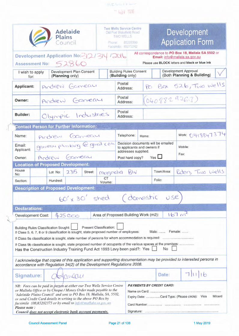
APPLICATION NO. 312/314/2016
APPLICANT Mr Andrew Gameau
DEVELOPMENT PROPOSAL Construction of a Domestic Outbuilding and associated earthworks
LODGEMENT DATE 7 November 2016
LOCATION Lot 235 (D34278) Magnolia Boulevard, TWO WELLS
ZONE Rural Living and Precinct 3 Two Wells
NATURE OF DEVELOPMENT Merit
PUBLIC NOTIFICATION Category 1
ASSESSING OFFICER Trevor V White – Planning Consultant
REFERRALS No Referrals under Schedule 8 of the Development Regulations 2008
DEVELOPMENT PLAN VERSION Consolidated 21 April 2016
RECOMMENDATION Development Plan Consent to be REFUSED
BACKGROUND: A Development Application was lodged by the applicant with the Adelaide Plains Council on 7 November 2016. The site of development (‘subject land’) is located within what is defined as the ‘Eden’ development being undertaken by the Hickinbotham Group. The ‘subject land’ is contained within the Rural Living Zone contained within the Mallala Council Development Plan 21 April 2016 – consolidation.
A Development Application, 312/159/2016 for the construction of a single storey detached dwelling on the ‘subject land’ received Development Plan Consent on 6 September 2016.
As part of the land purchase process, Council is required to issue a Section 7 Statement under the Land and Business (Sale and Conveyancing) Act 1994. The purpose of the statement under Section 7 of this Act is to put land purchasers on notice to particular concerns relating to the land to be acquired. Therefore, considering the ‘subject land’ is entirely contained within the Rural Living Zone of the Hickinbotham ‘Eden’ development it is fair to state that the applicant would have been advised that the allotment was subjected to varying levels of flood inundation, which meant flood mitigation action would need to be undertaken to satisfy zone policy provisions associated with various forms of development on the ‘subject land’.
As part of the assessment process, this report will undertake, an assessment of the actual outbuilding and associated earthworks (inundation measures) located in an area that is subjected to flood inundation, but also whether the use of ‘wet flood proofing techniques’ satisfies the policy provisions within the General Modules and Zone provision regarding mitigating the impacts of a 1 in 100-year ARI flood event.
The term ‘wet floodproofing’ is a design method that allows floodwaters to move through an enclosed building, such as a domestic outbuilding and then re-access the building when floodwaters recede. The argument put forward for allowing ‘wet floodproofing’ is that the finished floor level (FFL) of the proposed outbuilding can be built below the 1 in 100-year floodplain level. A report by AWE Hydrological Engineers suggested that openings could be placed in the walls of the building, near ground level, to allow water to pass through the building, thus reducing the pressure on the walls of the building, created by the flood waters. However, items such as electrical panels and outlets would need to be placed above the 1 in 100-year flood level, however this method does not prevent damage to the building from objects moving in the floodwaters.
The practical benefits of wet flood proofing as defined in AWE advice are listed below
Setting the sheds at a lower level would help to ensure that they are left unattended during a flood and people effectively evacuate the shed before surrounding flood waters become too deep and make it less safe; and
Council Assessment Panel Page 10 of 138 1 May 2019

CAP Agenda 01/05/2019
Establishing a lower level will reduce the volume of fill material to be placed in the floodplain and further minimise any disruption to the movement of flood waters.
However, the AWE advice also identifies several obligations that the landowner would need to adopt for the implementation of a ‘wet flood proofing measure’, those being:
The landowner would need to formally recognise the flood risk and accept liability for any damages to their property or damages to others that flooding of the shed may cause.
The shed must not be habitable, nor used for that purpose;
The domestic outbuilding would need to be designed by a suitably qualified designer to ensure that the building can withstand partial inundation, including:
Foundations of the building must be able to maintain the necessary support for the structure during the flood situation;
The section and areas of the building potentially inundated should be constructed from flood damage resistant materials to reduce flood damage and facilitate clean-up (For example: walls could be constructed of steel frames and cladding (eg colorbond); any internal linings should be of water resistant material, any timber within the inundation depth should use marine grade timber products, floors should be concrete slabs or course gravel (eg 15mm gravel) or if finer rubble material is used for floorings they should be cement treated.
Sheds to be configured to minimise damage from inundation (eg water able to drain from inside the building and layout inside the building enables simple clearing of the floor area;
Shelving and power outlets and any unsealed containers, or stored material subject to damage by floodwaters within the building to be set 150mm above the 1 in 100-year flood level (ie no lower than 12.47m AHD;
The building designer certifying that these conditions are satisfied; and
Any large plant or equipment stored in the building (eg tractors, boats etc) that are susceptible to damage from floodwaters are to be readily relocated to high ground out of the flood.
The AWE Report suggests that the above measures would promote the effective use of the wet flood proofing treatments to facilitate the installation of a large building/workshop and equipment on the ‘subject land’ in a practical manner.
The more relevant question relates to the size of the existing building platforms, as to whether 900m² is of adequate size and shape to cater for rural living allotments where not all buildings are going to be grouped together, considering all of the rural living allotments within this development are subjected to varying levels of flood inundation.
The term ‘dry floodproofing’ is a design technique where the finished floor level (FFL) of the proposed built form (dwellings and outbuildings) are constructed above the 1 in 100-year floodplain level, thus making the building waterproof and not subjected to floodwater pressure on the building.
As part of the applicant’s documentation submitted by AWE to support the concept of ‘wet flood proofing’, Council have engaged the professional services of Southfront (Hydrological Engineers) to undertake a risk based assessment of the alternative flood proofing methods (‘dry’ versus ‘wet’) as they relate to the proposed outbuilding.
Southfront took the opportunity to review the full range of background information provided by Council before preparing their report and excluding any planning or legal matters associated with the Development Application. The independent report provides a qualitative assessment of the relative merits of dry versus wet flood proofing as they relate to the subject land.
After considering the following aspects listed below:
Filling in the floodplain; Current and Future Use of the Outbuilding; Electricity; Access Provisions and Flood Warning Times; Water Level Equalisation and Outbuilding Security.
The independent advice concluded that the ‘wet flood proofing’ approach was not without some merit; it would however lower the threshold at which the proposed outbuilding would be subject to a residual flood risk to less than a 1 in 100-year ARI event. The proposed ‘wet flood proofing’ approach also carries a higher
Council Assessment Panel Page 11 of 138 1 May 2019

CAP Agenda 01/05/2019
risk, through the potential circumstances that could give rise to an increased likelihood and/or consequence of flood damage, than a conventional dry flood proofing method and therefore recommended Council require a dry flood proofing approach be adopted for the proposed outbuilding.
In addition to the documentation lodged as part of the development application the following additional information has also been provided to Council for consideration:
Response to Council, November 2018 - prepared by the applicant’s planning consultant;
Planning Statement 2August 2018 – prepared by the applicant’s planning consultant; and
A Flood Report February 2018 – prepared by Australian Water Environment (AWE)
The question of who would be liable for any damages to the building, items and fixtures contained within the building, should the building be affected by flood inundation has been raised with the applicant offering a number of options to reduce the risk to Council, should the proposal be granted Development Plan Consent. The options offered are listed below:
Preparation of an Emergency Management Plan (EMP) containing early warning mechanisms and evacuation procedures – which could be required by condition;
Condition requiring tenants or future owners to comply with EMP; Owner to sign waiver confirming acceptance of liability; Disclaimer in form of note on consent; and Limit approval to current applicant with subsequent land owners submitting new applications.
On receipt of the above options, Council sought legal advice in regards to the effectiveness of the above measures in discharging liability from Council in the event that the shed (or property within) is damaged as a result of Council’s Approval of a finished floor level (FFL) below the predicted flood level.
Legal advice provided the following advice relevant to Council’s Development Plan:
development should minimise the risks to safety and property of flooding from the Gawler River, Salt Creek and the Light River;
dwellings and ancillary buildings and structures will be located and designed to prevent entry by floodwaters. This will primarily be achieved through the raising of floor levels above the flood level, although alternative solutions may be appropriate in limited circumstances provided specific flood proofing measures are included within any design and constructions;
all dwellings, outbuildings and fences should be designed and sited in a matter that does not result in flood waters increasing the potential hazard risk to public safety and persons during a flood event;
development should be excluded from areas that are vulnerable to, and cannot be adequately and effectively protected from, the risk of hazards;
there should not be any significant interference with natural processes in order to reduce the exposure of development to the risk of natural hazards;
development should not occur on land where the risk of flooding is likely to be harmful to safety or damage property;
development in the GRFP should be designed and sited to minimise the flood impacts that occur within Flood Zone Areas 1, 2 and 3;
development should not be undertaken in areas liable to inundation by tidal, drainage or flood waters unless the buildings are designed and constructed to prevent the entry of floodwaters in a 1 in 100-year flood event;
finished floor levels for outbuildings should be a minimum of 150mm above the height of the 1 in 100-year flood levels or 150mm above the natural surface level whichever is the greater.
The advice also states that from the issues highlighted above it is apparent that there is a clear presumption against development in flood prone areas and that the primary focus of the Development Plan is preventing the entry of flood waters into buildings and structures.
The advice further outlined in detail but acknowledges that Council, as a public authority, owes common law duties of care to individuals when exercising its statutory powers.
In addition the advice also pointed out that as the land is in the Gawler River Flood Plain (GRFP) the applicant should already have an EMP which contains early warning mechanism and evacuation procedures. It is therefore our advice that it would be inappropriate to impose a condition requiring the preparation of an EMP with the intention that the same would aid in discharging the Council’s duty of care, subsequent to it
Council Assessment Panel Page 12 of 138 1 May 2019

CAP Agenda 01/05/2019
granting DPC to a development that was contrary to the provisions of the Development Plan. Similarly, the advice considers it unlikely that the Council would be able to prove that the EMP was not complied with and subsequently seek to enforce the same.
They have also suggested that even where waivers are fully agreed by all parties, they are often read down by the Courts, particularly where they purport to limit the liability of a statutory or Government authority. They consider, given the relevant provisions of the Development Plan which speak against approving the DA, it is highly likely that the waiver would not serve to protect the Council in any future action against it arising from the flooding of the Land.
Advice was also provided in relation to Limiting Development Approval.
DPC’s and other forms of development authorisations cannot be limited to a single person except in the rarest and most extenuating circumstances. We do not consider such a measure to be appropriate in these circumstances.
Even if it were possible to limit a development authorisation to a single person in these circumstances, an attempt to do so would be unlawful. This is because the limitation is only sought to circumvent the fact that the DA, as assessed against the Development Plan should be refused.
As part of the Hickinbotham ‘Eden’ development within the Rural Living Zone and Precinct 3 Two Wells, part of the development involved the construction of a 900m² building platform that was initiated by the developer and was approved by both Council’s Engineering and Planning staff.
Whilst different terminology has been used by the developer to describe the building platforms (eg residential earthworks, rural living earthworks platform, block filling etc), the intention of the building platforms was that the finished level of the platforms be equal to the level of the 1 in 100 year ARI flood level, with the finished floor level of dwellings being constructed 300mm above the platform level and 150mm above the platform level in the case of domestic outbuildings within the Gawler River Flood Plain.
SITE AND LOCALITY: The ‘subject land’ is described as Allotment 235 (D113928) Hundred of Port Gawler, 2 Magnolia Boulevard at Two Wells and contained within Certificate of Title Volume 6181 Folio 175.
The ‘subject land’ has a total area of 1.445 hectares, with a consolidated frontage to Magnolia Boulevard and Secomb Road of 53.25 metres and 94.330 metres respectively. The allotment has varying levels of flood inundation associated with a 1 in 100-year ARI flood event. The ‘subject land’ is entirely contained within the Rural Living Zone and Precinct 3 Two Wells and is surrounded by general farming land to the east and south of the site, residential properties to the west with other rural living allotments to the north with general farming land beyond the extent of rural living allotments.
PROPOSAL: The applicant seeks Development Plan Consent for the construction of a domestic outbuilding measuring 18.200 metres x 10.000 metres x 3.658 metre wall height. The proposed walls and roof of the proposed building will be clad in prepainted steel sheeting with an external finish that is commensurate with the colour scheme approved for the single storey detached dwelling approved on 6 September 2016 via DA 312/159/2016. The proposed building will be located some 7.000 metres from the southern boundary of the allotment and 65.000 metres from the south-western corner of the allotment, thus locating the domestic outbuilding behind the approved dwelling (refer to Location Plan attached in Appendix ‘A’. This locates the proposed building within the Hazard Zone 2 of the Gawler River Flood Plain. The rural living allotments are within the area designated as the Gawler River Flood Plain (GRFP), which contains 3 Hazard Zone categories:
Hazard Zone 1 (wading becomes unsafe) Hazard Zone 2 (vehicles become unstable); and Hazard Zone 3 (vehicles and wading unsafe).
Located on the northern aspect of the proposed building will have a PA door and double sliding doors and two openings suitable for the installation of roller doors. The proposal is not only for the construction of the building but also the extent of earthworks on which the building would be erected, taking into consideration the impact on the building and earthworks on a 1 in 100-year ARI flood event.
Council Assessment Panel Page 13 of 138 1 May 2019

CAP Agenda 01/05/2019
NATURE OF DEVELOPMENT AND CLASSIFICATION: The applicant seeks consent to construct a domestic outbuilding measuring 18.200 metres x 10.000 metres wide x 3.658 metre wall height, located within the Rural Living Zone and Precinct 3 Two Wells of the Mallala Council Development Plan (21 April 2016 – consolidation) which supports the construction of a single storey detached dwelling and associated outbuildings.
As part of the Hickinbotham ‘Eden’ development within the Rural Living Zone and Precinct 3 Two Wells, part of the development involved the construction of a 900m² building platform that was initiated by the developer and was approved by both Council’s Engineering and Planning staff.
Whilst different terminology has been used by the developer to describe the building platforms (eg residential earthworks, rural living earthworks platform, block filling etc), the intention of the building platforms was that the finished level of the platforms be equal to the level of the 1 in 100 year ARI flood plan, with the finished floor level of dwellings being constructed 300mm above the platform level and 150mm above the platform level in the case of domestic outbuildings within the Gawler River Flood Plain.
The original location proposed by the applicant for the domestic outbuilding was proposed 40.000 metres from the existing building platform and 2.000 metres from the northern boundary of the allotment. This original location would have placed the proposed outbuilding within the Hazard Zone 3 of the Gawler River Flood Plain and as such the proposed development would have been deemed to be a ‘non-complying’ form of development.
The applicant, with the assistance of Council planning staff agreed to a new location, with the building being located 7.000 metres from the southern boundary of the allotment and behind the existing dwelling on the allotment. The proposed building would also be located some 65.000 metres from the south-western corner of the ‘subject land’. This now placed the proposed building in Hazard Zone 2 of the Gawler River Flood Plain. Had Council agreed to the original position then the application for the proposed domestic outbuilding and associated earthworks would have been a ‘non-complying’ form of development. (Refer to the agreed Site Plan attached).
Development Plan Consent has been granted for the construction of a single storey detached building via DA 312/159/2016, with that approval being granted on 6 September 2016.
Reference has been made to the Procedural Matters contained within the Rural Living Zone, which states the following in relation to buildings and structures within the Gawler River Flood Plain:
The proposal fails to comply with the prescribed forms of development listed in Schedule 4 of the Development Regulations 2008 and as such cannot be deemed to be a complying form of development.
The non-complying form of development within the zone states the following:
Form of development Exceptions
Building or structure within the Gawler River Flood Plain, as shown on the Overlay Maps – Development Constraints Maps
Except where: a) It facilitates the provision of public infrastructure
for flood mitigation or flood management purposes
b) The total floor area of the buildings or structures measure less than 8 percent of the area of the allotment within Hazard Zone 1 and/or Hazard Zone 2 of the Gawler River Flood Plain as shown on the Gawler River Flood Hazard map – GRO Map No. 238/1993
As the total area of the approved dwelling and proposed domestic outbuilding is less than 8 percent of the total area of the allotment which in this case equates to 1156m², then the proposal for the construction of a domestic outbuilding in association with an approved dwelling is not deemed to be a ‘non-complying’ form of development and as such will be assessed on ‘merit’.
Public Notification: Reference has been made to the Rural Living Zone public notification categories where Council’s Development Plan is silent on the category of public notification for the construction of a domestic outbuilding associated with an approved or existing dwelling:
Reference has therefore been made to Schedule 9, Part 1 of the Development Regulations 2008, which states the following:
Council Assessment Panel Page 14 of 138 1 May 2019

CAP Agenda 01/05/2019
Part 1 – Category 1 development 2 Except where the development is classified as non-complying under the relevant Development Plan, any
development which comprises—
(d) the construction of (or of any combination of) a carport, garage, shed, pergola, verandah, fence, swimming pool, spa pool or outbuilding if it will be ancillary to a dwelling; or
In summary, the proposal is for the construction of a domestic outbuilding and associated earthworks, which is ancillary to a dwelling that was approved on 6 September 2016 via DA 312/159/2016 and is therefore not a ‘non-complying’ form of development, then the proposal will be assessed as a Category 1 kind of development for the purposes of public notification in accordance with Part 1, 2(d) of Schedule 9 of the Development Regulations 2008.
AGENCY REFERRALS: There were no requirements under Schedule 8, of the Development Regulations 2008 for referral of the application to any of the Government Agencies.
The ‘subject land’ is located within the General Bush Fire Risk Area as depicted on BPA Map Mal/13 of Council’s Development Plan, consolidated 21 April 2016 and as such there is no mandatory referral to the CFS under Schedule 8 of the Development Regulations 2008.
ASSESSMENT: In assessing the proposal for the construction of a domestic outbuilding and associated earthworks located within the Rural Living Zone and Precinct 3 Two Wells the proposal will be considered against the relevant policy provisions contained within the General Modules, Zone and Precinct policy provisions contained within Council’s Development Plan (21 April 2016 – consolidation).
GENERAL MODULES PROVISIONS:
Design and Appearance: Objective 1 Development of a high architectural standard that responds to and reinforces positive aspects of
the local environment and built form.
PDC 7 The external walls and roofs of buildings should not incorporate highly reflective materials which will result in glare to neighbouring properties or drivers.
PDC 20 Sheds and garages, other than stables, kennels and animal pens, should not be of a size that will visually dominate surrounding dwellings.
The proposed domestic outbuilding has been architecturally designed by Olympic Industries who are one of the major long standing shed building manufacturers in South Australia.
The proposed shed will be clad in pre-painted steel sheet cladding with the colour scheme of the proposed building will be commensurate with the colour scheme approved for the existing dwelling. Council requires the external finish of the building to be non-reflective to ensure there is no glare impact on the neighbouring properties or users of adjoining public roads. The proposed domestic outbuilding will be 18.200 metres x 10.000 metres x 3.658 metre wall height, which equates to a total floor area of 182.00m², which is not considered to be a dominant feature on the ‘subject land’ when the area of the allotment (larger allotment) which is equal to or greater than 1 hectare.
In summary, the proposed outbuilding is an appropriate size for the intended use within the rural living zone.
Hazards: Desired Character Statement:
Dwellings and ancillary buildings and structures will be located and designed to prevent entry by floodwaters. This will primarily be achieved through the raising of floor levels above the flood level, although alternative solutions may be appropriate in limited circumstances provided specific flood proofing measures are included within any design and construction.
The desired character statement provides a clear message that both dwellings and ancillary structures are to be designed to prevent the entry of floodwaters. It also suggests under limited circumstances an alternative solution may be considered.
Council Assessment Panel Page 15 of 138 1 May 2019

CAP Agenda 01/05/2019
The AWE report presented several practical benefits supporting the concept of ‘wet flood proofing’ which have been listed earlier in the report. Council took the opportunity to seek independent hydrological advice (provided by ‘Southfront’) who undertook a risk-based assessment of the alternative flood proofing method (‘dry’ versus ‘wet’) as they relate to the proposed outbuilding.
The ‘Southfront’ report concluded by stating the following:
‘The applicant’s proposed wet flood proofing approach, while not without merit, would lower the threshold at which the proposed outbuilding would be subject to a residual flood risk to less than a 1 in 100-year ARI event. The proposed wet flood proofing approach also carries a higher risk, through the potential circumstances that could give rise to an increased likelihood and/or consequence of flood damage, than a conventional dry flood proofing approach’.
‘It is therefore recommended that Council require a dry flood proofing approach to be adopted for the proposed outbuilding at Lot 235 Magnolia Boulevard, Two Wells’.
Objective 6 Development in the Gawler River Flood Plain which is designed and sited to minimize the varying potential flood impacts that occur within ‘Flood Hazard Zone 1’, ‘Flood Hazard Zone 2’ or ‘Flood Hazard Zone 3’, as shown on the Gawler River Flood Hazard Map - GRO Map No. 238/1993.
PDC 4 Development should not occur on land where the risk of flooding is likely to be harmful to safety or damage property.
PDC 5 Development should not be undertaken in areas liable to inundation by tidal, drainage or flood waters unless the development can achieve all of the following:
(a) it is developed with a public stormwater system capable of catering for a 1-in-100-year average return interval flood event
(b) buildings are designed and constructed to prevent the entry of floodwaters in a 1-in-100-year average return interval flood event.
PDC 6 Within the ‘Gawler River Flood Plain’ as shown on the Overlay Maps – Development Constraints:
(a) the finished floor level for dwellings, buildings for the keeping of animals, and gully traps should be a minimum of 300 millimetres above the height of a 1-in-100-year average return interval flood event of the Gawler River or natural surface level, whichever is greater
(b) the finished floor level for outbuildings should be a minimum of 150 millimetres above the height of a 1-in-100-year average return interval flood event of the Gawler River or natural surface level, whichever is greater
(c) allotments should contain sufficient area to accommodate the uses for which the land is intended
(d) filling for purposes ancillary to or associated with an approved use of land should be to a maximum of 100 millimetres above natural ground level
(e) filling required to raise the finished floor level of a building should not extend more than 10 metres beyond the external walls of that building
(f) driveways should be: (i) filled to a maximum of 100 millimetres above natural ground level (ii) no more than 5 metres wide.
PDC 7 Development, including earthworks associated with development, should not do any of the following: (a) impede the flow of floodwaters through the land or other surrounding land (b) increase the potential hazard risk to public safety of persons during a flood event (c) aggravate the potential for erosion or siltation or lead to the destruction of vegetation during a
flood (d) cause any adverse effect on the floodway function (e) increase the risk of flooding of other land (f) obstruct a watercourse.
Objective 6 applies to all development within the Adelaide Plains Council Area where development is proposed in Flood Hazard Zones 1, 2 or 3 as shown on the Gawler River Flood Hazard Map – GRO Map No 238/1993. The intent of the objective can be used to support the argument for both ‘wet’ and ‘dry’ floodproofing and is unclear as to what design and location techniques need to be employed to minimise potential flood impacts.
Council Assessment Panel Page 16 of 138 1 May 2019

CAP Agenda 01/05/2019
In a Planning Report prepared by Philip Brunning & Associates Pty Ltd, Town Planning Consultants, and sent to Council’s CEO, it suggested that ‘wet flood proofing measures’ is an accepted method by many authorities for managing non-residential buildings in flood prone areas. However, the report failed to provide any examples where this method had been adopted in South Australia.
Over a period of time since the lodgement of the development application on 7 November 2016 the applicant has offered a number of options such as the preparation of an Emergency Management Plan (EMP) containing early warning mechanisms and evacuation procedures – which could be required by condition, condition(s) requiring tenants or future owners to comply with EMP, owner to sign waiver confirming acceptance of liability, disclaimer in form of note on consent; and limiting approval to current applicant with subsequent land owners submitting new applications in order to discharge liability from Council in the event that the shed (or property within) is damaged as a result of Council’s Approval of finished floor level (FFL) below the predicted flood level.
It was asked that legal advice be given in relation to the options suggested by the applicant to discharge liability from Council. The advice received by Council from their legal counsel overwhelmingly concluded that the assurances proposed by the Applicant did not alleviate the planning issues concerning the outbuilding or otherwise appropriately discharge the liability, and thus the duty of care that attaches to the Council in these circumstances, thus suggesting the application should be refused.
PDC 4 listed above is quite clear and defined in that development should not occur on land where the risk of flooding is likely to be harmful to safety or damage property.
PDC 5(b) further reinforces the argument for ‘dry flood proofing’ by stating that buildings and structures should be designed and constructed to prevent the entry of floodwaters in a 1 in 100-year ARI flood event.
PDC 6, which is planning policy that has been inserted into Council Development Plan as a local addition, which means it is unique to development on land contained within the Gawler River Flood Plain. PDC 6(b) also reinforces the fact that the finished floor level (FFL) for outbuildings should be a minimum of 150mm above the height of the 1 in 100-year ARI flood event or natural surface level, whichever is the greater. This policy quite clearly supports the building of structures (outbuildings) to a height that is not affected by flood inundation.
PDC 6(f) provides some clear direction in relation to driveways to outbuildings or other structures on the ‘subject land’ where the height of fill for any driveway should not exceed 100mm above natural surface level and no more than 5 metres wide. This policy suggests that any access to the proposed structure needs to have minimal impact on the existing topography by limiting the depth and width of any fill.
PDC 7 of the Hazards General Module provides some guidance in relation to the development and earthworks in areas that are subjected to flood inundation. The ‘subject land’ is devoid of vegetation and a watercourse and therefore in this instance PDC 7(c) and (f) have no impact on this proposal. From the correspondence provided by Council, AWE hydrological engineers were required to provide expert advice on any earthworks involved with this proposal and the impact the earthworks may have on the flow of floodwaters within the site and adjoining properties.
As part of the Hickinbotham ‘Eden’ development within the Rural Living Zone and Precinct 3 Two Wells, part of the development involved the construction of a 900m² building platform that was initiated by the developer and was approved by both Council’s Engineering and Planning staff. A Development Application for filling in a floodplain (non-complying) was lodged by Hickinbotham (the developer) via DA 312/249/2018, which was supported by Council and concurrence received from SCAP on 7 February 2019.
Residential Development: PDC 16 Garages, carports and outbuildings should have a roof form and pitch, building materials and
detailing that complement the associated dwelling.
PDC 17 Garages and carports facing the street should not dominate the streetscape.
PDC 18 Residential outbuildings, including garages and sheds, should not be constructed unless in association with an existing dwelling.
As indicated earlier in this report the proposed outbuilding will be clad in pre-painted steel sheet cladding and with the colour scheme of the proposed building being commensurate with the colour scheme approved for the existing dwelling with a non-reflective external finish that will not result in glare to the neighbouring properties or users of adjoining public roads. The building has been designed and will be manufactured by Olympic Industries, who are a long standing major shed manufacturer in South Australia. The proposed outbuilding measuring 18.200 metres x 10.000 metres x 3.658 metre wall height is proposed to be erected some 65 metres from the south-western corner of the allotment and to the rear of the existing dwelling constructed on the site. Whilst the proposed building is larger than normally associated with
Council Assessment Panel Page 17 of 138 1 May 2019

CAP Agenda 01/05/2019
residential development, it is commensurate with the size of the allotment and partially hidden by being placed at the rear of the existing dwelling and therefore does not dominate the streetscape.
Approval was granted on 6 September 2016 for the construction of a single storey detached dwelling via DA 312/159/2016, and therefore the construction of a domestic outbuilding satisfies PDC 18 of the Residential General Module of Council’s Development Plan (21 April 2016 – consolidation).
Siting and Visibility: PDC 2 Buildings should be sited in unobtrusive locations and, in particular, should:
(a) be grouped together (b) where possible be located in such a way as to be screened by existing vegetation when viewed
from public roads.
PDC 2 of the Siting and Visibility General Module suggests that buildings should be placed in unobtrusive locations and be grouped together. Whilst the proposed domestic outbuilding will be located some 65.000 metres from the south-western corner of the allotment and behind the existing dwelling, the question needs to be asked as to whether agreed location fragments the outbuilding from the existing dwelling (not grouped together) and needs to be constructed on the agreed building platform in order to comply with PDC 2(a).
RURAL LIVING ZONE: Objective 2 Minimisation of risks to safety and property of flooding from the Gawler River, Salt Creek and
the Light River. PDC 1 The following forms of development are envisaged in the zone:
detached dwelling domestic outbuilding in association with a detached dwelling dwelling addition farming farm building flood mitigation measures home based industry/ office (other than in Precinct 3 Two Wells) horse keeping and associated stables (other than in Precinct 3 Two Wells) keeping of dogs, other livestock, birds or poultry at low densities (other than in Precinct 3 Two Wells) public outdoor recreation activities.
Objective 2 for the Rural Living Zone focuses on minimising the risk to both safety and property damage as a direct result of flood inundation from both the Gawler and Light Rivers. The implementation of ‘dry flood proofing measures’ satisfies Objective 2 as the finished floor levels of both dwellings and outbuildings would be above the 1 in 100-year ARI flood level and therefore not subjected to flood inundation. The proposed development for the construction of a domestic outbuilding measuring 18.200 metres x 10.000 metres wide x 3.658 metre wall height is associated with an approved dwelling that was approved by Council on 6 September 2016 via DA 312/159/2016 and therefore complies with PDC 1. PDC 8 All buildings associated with a home-based industry/ office, sheds (except for stables, kennels and
animal pens), garages and similar outbuildings should be designed within the following parameters:
Parameter Value Maximum floor area 300 square metres Maximum building height (from natural ground level) 6.5 metres Maximum wall height (from natural ground level) 4.2 metres Minimum setback from primary road boundary where the floor area is 36 square metres or less and the vertical wall height measures no more than 2.7 metres
15 metres or the same distance as the existing associated dwelling, whichever is greater
Minimum setback from primary road boundary where the floor area is greater than 36 square meters
20 metres or the same distance as the existing associated dwelling, whichever is greater
Minimum setback from side road boundary
8 metres plus 3 additional metre for every additional 500 millimetres above the 2.7 metres wall height measured from natural ground level
Council Assessment Panel Page 18 of 138 1 May 2019

CAP Agenda 01/05/2019
Minimum setback from side boundaries
5 metres plus 1 additional metre for every additional 500 millimetres above the 2.7 metres wall height measured from natural ground level
Minimum setback from rear boundary 12 metres In relation to PDC 8, the proposal complies with the following parameters and values:
Maximum floor area – 182.00², which is less than the maximum suggested of 300m²
Maximum building height (from natural ground level) will be 4.717 metres – which is less than the suggested maximum height of 6.500 metres
Maximum wall height (from natural ground level) will be 3.658 metres which is also less than the suggested 4.200 metres
Minimum setback from primary road boundary where the floor area is 36 square metres or less and the vertical wall height measures no more than 2.7 metres – the proposed domestic outbuilding is proposed to be located 26.000 metres behind the existing dwelling located on the site.
Minimum setback from primary road boundary where the floor area is greater than 36 square meters (20 metres or the same distance as the existing associated dwelling, whichever is greater) - the proposed domestic outbuilding is proposed to be located 26.000 metres behind the existing dwelling located on the site.
Minimum setback from side boundaries (5 metres plus 1 additional metre for every additional 500 millimetres above the 2.7 metres wall height measured from natural ground level) – Considering the wall height of the proposed outbuilding will be 3.658 metres, which is 0.958 metres more than the suggested 2.700 metres, which means the proposed building needs to be constructed a minimum of 7.000 metres from the side boundary of the allotment.
Minimum setback from rear boundary (12 metres) – The location of the proposed outbuilding will be greater than the 12.000 metres suggested.
In summary, the proposed domestic outbuilding satisfies the parameters for a domestic outbuilding in the Rural Living Zone.
Precinct 3 Two Wells PDC 22 Dwellings should be setback a minimum of 10 metres from the primary street frontage and 3
metres to the secondary street frontage. The primary street setback can be reduced to 5.5 metres at the interface of the Residential Zone.
PDC 23 All dwellings should have a finished floor level 300 millimetres above the anticipated 1-in-100 average return interval flood level based at post levee construction.
PDC 24 All dwellings, outbuildings and fences should be designed and sited in a manner that does not result in flood waters increasing the potential hazard risk to public safety of persons during a flood event.
Precinct 3 Two Wells, which covers the rural living allotments within the ‘Eden’ development on the eastern periphery of the Two Wells township, provides further measure to be considered in assessing development within the Gawler River Flood Plain. PDC 23 is quite clear in that the finished floor level of dwellings in this precinct must be 300mm above the 1 in 100-year ARI flood level. The finished level of the existing 900m² building platforms has been constructed to the 1 in 100-year ARI flood level, hence the finished floor level (FFL) should be 300mm above the finished level of the existing building platform.
PDC 24 suggests that all structures (dwellings and outbuildings, including fences) need to be designed and sited in a manner that does not result in flood waters increasing the potential hazard risk to public safety of persons during a flood event. Precinct 3 Two Wells would have also been an appropriate location to further reinforce the fact that outbuildings could be constructed so that the finished floor levels (FFL) is 150mm above the 1 in 100-year ARI flood level.
CONCLUSION: A development plan is a statutory policy document which guides the type of development that can occur within a council area and assists a planner in assessing development applications. Every council in South Australia has a development plan that specifies the type of development that can occur in that council area.
Council Assessment Panel Page 19 of 138 1 May 2019

CAP Agenda 01/05/2019
Amendments to development plans are incorporated into the plans on a regular basis and recorded as the date of consolidation.
The detail in each development plan differs between councils to reflect local circumstances and issues; however, the role of the Development Plan is listed below:
inform the community about how an area is expected to be developed inform neighbours about the kinds of development they can expect in their neighbourhood inform applicants about the type of development that is encouraged in an area, therefore the type of
information that may be required in a development application provide the basis against which development assessment decisions are made; and provide the basis upon which any appeal decisions are made
In addition to the core policy provisions contained within Council’s Development Plan the planning framework allows Council to insert local policy additions that assist in achieving better planning outcomes within an area, zone, policy area or precinct. In this case Council have inserted several provisions regarding development within the Gawler River Floodplain (GRFP). It is apparent from the local additions that there is a clear presumption against development in flood prone areas and that the primary focus of the Development Plan is preventing the entry of flood waters into buildings and structures. It is expected that the construction on building platforms within the GRFP be constructed to the level of a 1 in 100-year ARI flood event. In the case of dwellings, the FFL is required to be constructed 300mm above the building platform, whilst the FFL of domestic outbuildings being 150mm above the 1 in 100-year ARI flood level. The focus of this policy is around preventing dwellings and other structures such as domestic outbuildings being protected from flood inundation during a 1 in 100-year ARI flood event. In an attempt to gain support for the ‘wet flood proofing’ option the applicant has offered a number of options such as the preparation of an Emergency Management Plan (EMP) containing early warning mechanisms and evacuation procedures – which could be required by condition, condition(s) requiring tenants or future owners to comply with EMP, owner to sign waiver confirming acceptance of liability, disclaimer in form of note on consent; and limiting approval to current applicant with subsequent land owners submitting new applications in order to discharge liability from Council in the event that the shed (or property within) is damaged as a result of Council’s Approval of finished floor level (FFL) below the predicted flood level.
Council has also sought both independent advice regarding the level of risk associated with the ‘wet flood proofing’ method from an suitably qualified hydrologist and also the legal ramification for Council should approval be granted for the damage to the shed and property within the building for constructing the building below the 1 in 100 year ARI floodplain. Advice from both these options suggest that the ‘dry flood proofing’ method is the one that needs to be adopted. The current policy has been developed to minimise impacts of a 1 in 100-year ARI flood event. Any proposal for the construction of a domestic outbuilding with a finished floor level below the 1 in 100-year ARI flood level is at variance to policy provisions listed above and as such the proposal in its current form cannot be supported.
RECOMMENDATION: 1. On the basis that this matter involves confidential legal advice the public, with the exception of the
Author of this report, Assessment Manager and Minute Secretary, be excluded from attendance at so much of the meeting as is necessary to receive, discuss and consider in confidence, information contained within the confidential report.
2. That Council’s Assessment Panel pursuant to Section 33 1(a) of the Development Act 1993, as amended, REFUSE Development Plan Consent for the application by Andrew Gameau for the construction of a domestic outbuilding and associated earthworks 312/314/2016 at Lot 235 (DP113928), Magnolia Boulevard TWO WELLS, for the following reasons: - The proposed development for the construction of a domestic outbuilding and associated earthworks is at variance with the following policy provisions contained within the General and Zone provisions General Hazard Module: Objective 6 PDC 4, PDC 5(b), PDC6(b), PDC 6(c) Rural Living Zone: Objective 2 PDC 1
Council Assessment Panel Page 20 of 138 1 May 2019
@t$:iil"Development Application 11o,--11-l 3.{ ,aUUAssessment No: 5 78 LC
''l,'i.i:
Two Wells Service CenlreOld Pr.,r1 Wakelrtld Fl,:,aC
TlYC !'^iEttS
P'irj'i[: Ec2arf,iF]ilt-,:trsimile. a1i!1 )- :!42
All correspondence to PO Box 18, Mallala SA 5502 orEmail: info@ mallala.sa.oov.au
Please uss BLOCK lsttets and black or blue ink
I wish to applytor:
Development Plan Consent(Planning only)
Building Rules Consent(Building only)
Development Approval(Both Planning & Building)
?c, Prcx alb 1'-fv.o vJe \\5F\{".d{ €v.J Qc-^rr.€Crur
. _ ^ -. \Oqd g 31- ', J(', ( )Andre"J Qc'r<a..'t
C\qr-.,,-,P rC \ rclr-r sk t€-S
C\igg*r r.th.-dr-€.-^.l Gr:."^ec,.i--4Decision documents will be emailedlo applicants and owners itaddresses supplied.
Post hard copy? Yes E
$ar.r'r€crr.-i g \gr5 ''lvjli (
c5r.,cr,\ 1 Or'.
hcdrew (ac^Y<c^u.,'
Er)en, -t'uo LJe\\Sfrrcro,rc\rA BtV
@'x 3C-l' 3h'ed ( dcr.e,stic u se
Area of Proposed Building Work (m2):
I acknowledge that copies of this application and supporting documentation may be provided to interested persons in
accordance with Regulation 34(2) ot the Development Regulations 2008.
rlrrlrbSignature:
PAYMENTS BY CBEDIT CAND:
Nams on Card:
E)eiry Dats: ........,.,.Card Type: (Please circle): Visa ltrl/card
NB: Fees can be paid in ler-gdn at either our Two Wells Semice Centre
or Mallala Offrce or by Cheque / Money Ordzr made payable to the
'Adelaide Plains Council' and sent to PO Box 18, Mallala, SA, 5502,
or send Credit Card details in writing to the above PO Box by
Jacsimile (08)85202375 or by emnil to inlit@ nrullulu.su.gttr .ttrt
Plcase note :
Develooment Cost: 25 e.-r,
Building Rules Classilicalion Soughl: | | Presont Classif ication:
lf Class 5, 6, 7, 8 or I classification is sought, slate proposed number of employees:
lf Class 9a classilication is soughl, state number of persons lor whom accommodation is required:
It Class 9b classilication is sought, state proposed number of occupants ol the various spaces at the pretiEi, . .... .
Has the Construction Industry Training Fund Act 1993 Levy been paid?: Yes Ll No LJ
Council Assessment Panel Page 21 of 138 1 May 2019Council Assessment Panel Page 21 of 138 1 May 2019

oProduct Register Search (CT 6181/175)
Date/Time 27l03l2$a 02:o0PMG6v*'inr'rrt or lolrlr
^t'ifrlLr customer Refersncs lsc8p' Order lD 20180327007648
-6Hh The Reqistrar-General certifies that this Title Register Search displays the records,affid maintained in the Register Book and other notations at the time of searching.
5s!1h .1|l5lr!li!
Gertificate of Title - Volume 6181 Folio 175Parent Titfe(s) Cr 61621917
Creating Dealing(s) RTC 12602699
Tifle lssued 2910912016 Edition 3 Edition lssued 1111112016
Estate TypeFEE SIMPLE
Registered ProprietorANDREW JOHN GAMEAUSTACEY ALISON GAMEAU
OF LOT 235 MAGNOLIA BOULEVARD TWO WELLS SA 5501AS JOINT TENANTS
Description of LandALLOTMENT 235 DEPOSITED PLAN 1 13928IN THE AREA NAMED TWO WELLSHUNDRED OF PORT GAWLER
EasementsSUBJECT TO SERVICE EASEMENT(S) OVER THE LAND MARKED D ON D113928 FOR DRAINAGE PURPOSES TOTHE COUNCIL FOR THE AREA (2231G RPA)
Schedule of DealingsDealing Number Description
12619792 ENCUMBRANCE TO ALANO UTILITIES Pry. LTD. (ACN: '1 18 218 572)
12619793 ENCUMBRANCE TO HICKINBOTHAM HOMES PTY. LTD. (ACN: 007 618 797)
12619794 MORTGAGE TO AUSTRALIAN CENTRAL CREDIT UNION LTD. (ACN: 087 651 125)
NotationsDealings Affecting Title NIL
Priority Notices NIL
Notations on Plan NIL
Registrar-General's Notes NIL
Administrative Interests NIL
Land Services Page 1 of 1
copyrightPrivacyDi5c|aimer:wwW.sai|is.sa.gov.au/home/showcopyright!./'5a||is.sa'Council Assessment Panel Page 22 of 138 1 May 2019Council Assessment Panel Page 22 of 138 1 May 2019

DEVELOPMENT REGULATIONS 2OO8
DECLARATION OF APPLICANT(BUILDING SAFELY NEAR POWERLINES)
(Pursuant to clause 2A(1) of Schedule 5)
To: District Council of MallalaEnvironmental Development ServicesPO Box 18 MALLALA SA 5502
From: Name
Address
Phone No 6\1$.iq1 119 Mobile
DateofApplication 1 t \ \ / (k)
LOCATION OF PROPOSED DEVELOPMENT
House No Lot No Street
{^\a\ ( < L!
Town/Suburb
Section No (tull/part)
Certificate of Title: Volume
Hundred
Folio
!-:e\\ E
NATURE OF PROPOSED DEVELOPMENT
| , Qnsert fult name) r.-fr-<-\{ ev.. l\3\'rr-r Ccrr-,-.ecl'--r
Being the applicant for the development described above declare that the proposed development willinvolve the construction of a building which would, if constructed in accordance with the planssubmitted, not be conirary io the regulations prescribed for the purposed of section 86 of the ElectricityAct 1996. I make this declaration under Class 2A (1) of Schedule 5 of the Development regulations2008.
rtrrl\cDate:Signedr
Note 1
This declaration is only relevant to those development applications seeking authoisation for a form of development that involves theconstruction of a building (there is a definition ot 'building' eontained in Section 4 (1) of the Development Act 1993.)
Note 2The rcquirements of section 86 of the Electricity Act 1996 do not apply in relation to:
a) Fence that is less than 2.0 mtrs in height: orb) A sevice line instalted specificatly to supply electricity to the building or slructurc by the operatot of the tnnsmission or
distibution netv'rork form which the electicity is being suppliedNote 3A Building Safaly Near Powerlines brochure has been prepared by the Technical Regulator lo assist applicants and other interestedpersons. Hard coples ot this btochure are available trom Councils and the Office ot the Technical Regulatot. The brochurcs and other
relevant information can also be found at www.technicalrequlator.sa.gov.au.
Note 4The majority of applications wil! not have any powerline lssue4 as normal residential sefbacks often cause the building to comply with the
prescibed clearance distances. Buildings/renovatlons tocated far away from powerlines, for example towards the back of propefties, willusually also comply.Pafticular care needs lo be taken wherc high voltage powedines exist; where the development:
. ls a major road;
. Commercial/industrial in nature: or
. Buift to the prcpefty boundary
Nole 5lnformation brochures 'Powsrline Clearance Declaration Guide'and 'Building Safaly Near Powerlines'have bee prepared by the TechnicalRegulator to assist applicants and other interest persons. Copies of these brochures are available from Council and the Office of the
Technicat Regulator. The brochures and other relevant information can also be found at www.techicalreoulatar.sa.aov.au
Nofe 6ln cases where applications have obtained a written approval from the Technical Regulator to build the development specilied above in itscurrent form within the presuibed clearance disfances, the applicant is able to sign the form.PLN/06/0024
Council Assessment Panel Page 23 of 138 1 May 2019Council Assessment Panel Page 23 of 138 1 May 2019

**ffi{l'%i\
23'o November 2018
Brendon SchulzAdelaide Plains CouncilPO Box 18Mallala, SA 5502
Dear Brendon,
RESPONSE TO MEETING TO DISCUSS PROPOSAL TO ERECT A SHED IN THE
FLOODPLAIN AT LOT 235 MAGNOLIA BOULEVARD, TWO WELLS (DA 312/314/2016)
Thank you for meeting with us on Friday the 91h of November to discuss the above
proposal and provide reasons for not supporting my Clienl's application. I take the
opportunity to provide additional information in support of my Clienl's proposal and torequest Council reconsider its position.
Gouncil's Current Position
Council takes the view that the proposal should nol be supported unless the floor levels
are raised on an island at least 150 mm above the 1OOyear flood level. You referred to the
latter as dry flood protection and contrasted this with the method proposed by my Clients
referring to it as wel flood protection. Council has reached this view mainly in
consideration of a perceived liability n'sk and a drafi report prepared by a planning
consultant (Trevor White). ll is noted that this report makes a case for dry flood protection
mainly on the basis of the flood provisions under Hazards in the Council Wide seclion plus
a selection of provisions within the Rural Living Zone.
Council has not sought independeni hydrological advice to support its views although ithas been suggested that the matter may have been discussed with another flood engineer
or engineers.
I also understand that Council is not suggesting that additional wet or dry flood proleclion
would be required for floods above the 1O0year flood such as 200year, 500year, and
1,000year events.
Among other things Council raised concerns about the use of a Land Management
Agreement to govern risk particularly where a tenant or visitors are involved and otherpeople's goods are stored within the shed. Furthermore Mr Veitch had concerns regarding
the risk the shed posed to road users in the vicinity of the subject land.
The proposal for broad filling of the front of the property affecting numerous otherproperties in lhe area was also discussed. My Clients expressed their support for theproposal pointing out that the additional raised area would provide space for any goods
RegionaI Planning
[)irections..
PC Box 67, Spr notor SA 5235
n 08 8568 2037 rtt. 0488 451 9i 0
le,rttorttgi.t alpa'tr,', irdr.r.r r\'01 rr,
',t'1r,, tegilfalp atutt,lEtlitecl ons r;ortr ': I
A8N C0 -!2
93b B5J
Council Assessment Panel Page 24 of 138 1 May 2019Council Assessment Panel Page 24 of 138 1 May 2019

and vehicles to be placed there a short distance trom the outbuilding in the event of aflood.
Llability and Development Declsions
Council's cunent position suggesls liability risk should be the dominant fastor determining
the outcome of an assessment against the relevant provisions of the Development Plan
regardless of any engineering advice or Developmenl Plan provisions io the contrary. lfthis were the case then Council should not have allowed the subdivision of the land in ihefirst place as no conditions or controls have been placed on storage of items such as cars,
trailers, or equipment wilhin the flood affected portions of the subjecl land.
Cleady such approach would be untenable firstly, because the Development Acl requiresCouncil to have regard lo the Development Plan in determining its development decisionsand liability is not even fastored as a requirement of the planning rules. Secondly, theRural Living Zone makes a clear exception for land division in Policy Area 3 and Council
had no alternative but to approve the land division. The upshol of this is ihai if the
Development Plan allovrs for it Council is only doing the right thing in approving a
development regardless of the liability question.
It is only common sense that if Council follows the planning rules and relevant engineering
advices then it would be unlikely to have any reason to be held liable in lhe evenl thatthere was a flood and any items and vehicles lefl on the flood prone portions of the subjectland were not removed by the land owner or occupant prior to a flood resulting in damageas it would clearly be the faull of lhe owner or occupier.
Equally liabilig should not be considered as a key contextual issue in the decision process
for the proposal at hand, as lhe relevant factors for consideration should only be the
relevanl planning rules and the advice of a hydrological engineer. The offer of entering
into a Land Management Agreemenl to indemniff Council was only suggested to provide
added assurances to Council and in my opinion is nol necessary to maintain compliancewith the planning requirements.
This view has been conoborated in discussions with Mr Jake McVicar Director ofDevelopment and Environmental Services for the Mid Munay Council where a
considerable number of sheds are regularly approved within the 1956 flood plain of theRiver Murray in accordance with the relevanl planning rules. So far no objections have
been raised either by the Minisler for the River Munay or the Local Govemment Mutual
Liability Scheme (LGMLS).
Interpretation of the Development Plan
You would be aware that the more detailed zone level provisions are usually given more
weight in an assessment than the general or Council Wide provisions particularly wherethese contradict each other. In this inslance the Council Wide provisions relevant loHazards generally seek to avoid development in flood plains or impose requiremenls forraising the finished floor levels above lhe looyear flood level. Al the same time theprovisions in the Rural Living Zone provide a clear reference io allemative flood prolection
measures as was highlighted in my earlier planning stalement as follows:
... a /esser than 150mm of freeboard, the entry af floodwaters, and a 200mm divewayar€ issues that have been envisaged at the zone level through the following rcfercnce in
Council Assessment Panel Page 25 of 138 1 May 2019Council Assessment Panel Page 25 of 138 1 May 2019

the Desired Chancter Statement for the Ruml Living Zone as follows:
Dwellings and ancillarv buildings and structures will be iocated and designed toprevent entry by floodwaters. This wiil pimaily be achieved through the raising
of floor levels above the flood level, although alternative solutions mav beappropriate in limited circumstances provided srycific flood proofinq measures
are included within anv desisn and construction. (my undedining)
As the zone provisions arc more spcific to the context of the zone and altemativemeasules have been suppofted by a qualifred hydrologial engineer I am of the viewthat the proposal accords with the relevant provisions in relation to flooding.
It is noted that Mr tAlhite did not tum his mind to the above excerpl from lhe desiredCharacier Statement for the Rural Living Zone prefening instead lo focus on elemenls that
supported his argument that the Development Plan Provisions did not contemplaleallernatives to the dry flood proteclion method.
Although raising the floor levels above the 1O0year flood level would prevent the entry offloodwaters up to the 100year flood level it would not provide prolection for higherincidents of flooding. In my opinion determining the appropriate level of flood protection
needs some interpretation in the context of the above and should not be seen as an
absolute level of protection for all incidences of flooding (e.9. 100year, 200year, 500year,
and '1,000 yearARl flood events).
In this instance the level of the pad 500mm above natural ground level may not be
sufficient for 100year flood protection but it would prevent the entry by floodwaters to areasonable extent possibly even for floods greater than a 50 year event. In lhecircumstances it is considered an appropriate level of flood prolection and has lhe supporlof an eminent hydrological engineer. Al the same time the proposal incorporates acontingenry for evacualion, which is likely to meel any shortfall for a higher level offlooding than the pad would provide, potentially even for incidences greater lhan a
100year flood event and would thereby be likely to have a mitigation effect for higherfloods.
Limiting the height of the pad has another significant benefit in that it would displace less
of the higher level flood waters and thereby is likely to reduce the potential for damage
downslream and to vehicles driving past, an issue Mr Veitch had significant concerns
about.
Furthermore the engineering requirements provided in the advice from Mr Geoff Fisherinclude depth markers and would be likely to inform all potential users of the land about
flood risk and the need to evacuate the shed.
Conclusion
There are shortcomings in Council's cunenl position not to support my Clienfs proposal
for a shed within the 100 year floodplain including:
. Council has nol soughl expert engineering advice in relation lo the proposal
whereas my Clients have;. Council is placing liability concems above the relevant development plan
provisions in deriving lheir view; and
Council Assessment Panel Page 26 of 138 1 May 2019Council Assessment Panel Page 26 of 138 1 May 2019

4
. Council has not turned its mind to the pivotal issue of allernalive approaches to
flood mitigation as @untenanced in the Desired Character Statement for the Rural
Living Zone;
In our view the proposal adequately addresses the need for flood prolection using a
combination of dry and wet protection plus a contingency for evacuation for higher flood
events with benefits potentially up to and exceeding a 1Ooyear evenl.
In view of the above we respectfully request that Council reconsider its position and
provide its support for the proposal so that my Clients are able to erect the shed they so
urgently need.
Should you require additional information or have any queslions in relation to the proposal
please do not hesitate to contact me on 08 85682037 or 0488451970 or via email on
henri@ reqiona lplanningd irections. com.au
Yours sincerely
---.3'."2*---Henri MuellerDIRECTOR - REGIONAL PLANNING DIRECTION
Council Assessment Panel Page 27 of 138 1 May 2019Council Assessment Panel Page 27 of 138 1 May 2019

Brendon Schulz
From:Sent:
Henri Mueller <[email protected]>Monday, 8 October 201B 10:49 AM
Tor Robert Veitch; Brendon SchulzCc: AndYGameauSubfect DAi12l314t2O16 Extent of Broad fill at Lot 235 Magnolla Boulevard, Two Wells
Attachments: AG amended site plan .pdf
Catogorlss: ActiveDocs
Hi Rob and Brendon,
Attached please find a copy of the site plan showing the extent of broad fill subject to a separate
application.
I belleve you now have all of the information that you require'
On behalf of my Client I request that Council finalise the processing of the application as soon as possible.
My Cllent would like to commence building work prior to Christmas so that his domestic storage can be
undercover and it has now been two years since the application was first lodged.
Please do not hesitate to contact me should you wish to discuss the matter further.
Kind regards
Henri Mueller - DreciorBA (Plan), GDRUP, M (env St), Prot Cart Mgil, MPIAPO Box 07, Spdngton SA 5235p.08 85682037 m.0488451 970www.reoional Dlannlnodiredions.com.su
This email has been scanned by the Symantec Email Security.cloud service.
For more information please visit http://www.symanteccloud.com
Council Assessment Panel Page 28 of 138 1 May 2019Council Assessment Panel Page 28 of 138 1 May 2019

IZ6T L L CI
Council Assessment Panel Page 29 of 138 1 May 2019Council Assessment Panel Page 29 of 138 1 May 2019
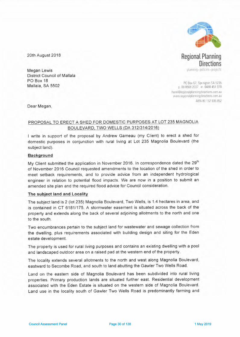
20lh August 2018
Megan LewisDislrict Council of MallalaPO Box 18Mallala, SA 5502
Regional Planning
Directions':.1
Dtl ho. 6r. (pr rg-,r. SA 5735
p 0B 8568 2037 r 0488 451 970
henriagre0i0ra planningditectiors.cuir au,,ai,\4,l, regronalplalnirgdirectr0ns.c0rr.au
ABN 80 r52 935 852
Dear Megan,
PROPOSAL TO ERECT A SHED FOR DOMESTIC PURPOSES AT LOT 235 MAGNOLIA
BOULEVARD, TWO WELLS (DA 312/314/2016)
I write in support of the proposal by Andrew Gameau (my Client) lo erecl a shed for
domestic purposes in conjunction with rural living at Lot 235 Magnolia Boulevard (the
subject land).
Background
My Client submitted the application in November2016. In correspondence dated the 29'n
of November 2016 Council reouested amendments to the localion of the shed in order to
meet selback requirements, and io provide advice from an independent hydrological
engineer in relation to potential flood impacts. We are now in a position to submit an
amended site plan and the required flood advice for Council consideration.
The subiect land and Locality
The subject land is 2 (lot 235) Magnolia Boulevard, Two Wells, is 1.4 hectares in area, and
is contained in CT 61811175. A slormwaler easement is situated across the back of theproperty and exlends along the back of several adjoining allotments to the north and one
to the south.
Two encumbrances pertain to ihe subject land for wastewaler and sewage collection from
the dwelling, plus requirements associaled with building design and siting for the Eden
estate develooment.
The property is used for rural living purposes and contains an existing dwelling wilh a pool
and landscaped outdoor area on a raised pad at the western end of the property.
The locality extends several allotments to the north and west along Magnolia Boulevard,
eastward to Secombe Road, and south to land abutting the Gawler Two Wells Road.
Land on the eastern side of Magnolia Boulevard has been subdivided inlo rural living
properties. Primary production lands are situated further east. Residential development
associated with the Eden Estate is situated on the western side of Magnolia Boulevard.
Land use in the locality south of Gawler Two Wells Road is predominantly farming and
Council Assessment Panel Page 30 of 138 1 May 2019Council Assessment Panel Page 30 of 138 1 May 2019

rural living. A landscaped area is situaled to the south of the subject land and forms part of
the slormwater management and enlrance to the Eden estate.
The topography is relatively low lying and falls gently from a rise west of Magnolia
Boulevard to a slormwalerbasin on the eastem edge of the locality. Sall creek is situaled
to the easl and runs and crosses the Two Wells Gawler Road close to the inlersec'tion wilh
Secomb Road. Land abutting the easiern side of Magnolia Boulevard is within the 1O0year
flood plain of both the Light and the Gawler Rivers and ihe rural living allotments on lhis
side of the road all have raised house pads towards the front of the property.
Details of Proposal
The proposal is to erecl a 21.8 meire by 10 metre colourbond (Woodland Grey) shed
covering 218 square metres in area. The wall height is to be 3.65m and lhe heighl to the
apexof lheroof would be4.Tm.Theshedistobesituatedontopof araisedpadSlOmm
above natural ground level and no less than 11.67mAHD (see flood advice from Geoff
Fisher).
The shed is to be used for domestic purPoses including the storage of a caravan, boat,
two trailers, a utility, a slasher/mower plus other personal items. There will also be a
workshop area for any projects undertaken by my Clients around the home'
The siting of the shed has been amended so that it would be 7m in from the southem
boundary and 20m east ofthe existing house pad (see figure 1 below). Access to the shed
is to be via a driveway along the norlhem side of the dwelling to a reversing erea
comprising a 7m wide pad adjacent to the entrance to the shed. The driveway is to be
raised 200mm and marker posts will be placed along the driveway to indicate flood depths.
Two 22.5 thousand litre poly rainwater tanks will be situated at the southern side of the
shed and any overflow will be directed into the garden area.
As the shed is to be situated below the 100year flood level of the Gawler River my Clients
have adopted details for flood management provided in the report prepared by Geoff
Fisher in relalion to siting and wet flood proofing. Accordingly the following will be
incorporated:
. Formal recognition of the flood risk and acceplance of liability for any damages to
property or damages will be provided by my Clients in writing;
. The shed will not be habitable, nor will it be used for that purpose;
. The shed will be designed by a suitably qualified designer to ensure that it can
withsland Partial inundation;. Foundalions will be able to mainlain the necessary support for the structure during
a flood situation:. The sections and areas of the shed potentially inundated will be conslructed from
flood damage-resistant materials lo reduce flood damage and facilitale cleanup.
. The shed will be configured lo minimise damage from inundation including intemal
drainage to faciliiate washing afler a flood;. Shelving, and any power outlets and any unsealed conlainers, or slored material
subject to damage by floodwaters wilhin the shed will be set 150 mm above the 1
in 100 year ARI flood level (ie no lower than 12.72 mAHD;
Council Assessment Panel Page 31 of 138 1 May 2019Council Assessment Panel Page 31 of 138 1 May 2019

. Certification from the shed designer will be provided at the building rules stage that
these conditions will be salisfied;. Equipment stored in the shed will be relocated to high ground out of the flood prior
to inu ndation
A Home Emergency Plan or HEP will be prepared by the applicants to Council and the
SES's satisfaction embodying early warning mechanisms and triggers for evacuation etc.
-'t .,.,: : ,i
iilrI
'*It
r -l!tI
-.i
II
ii
-\
l
Et"
WIEIta..".l
Etfl
IIffitriffi,1*#ffi
'h1",
f ,l't:!l'
Figure 1 Amended Site Plan
Council Assessment Panel Page 32 of 138 1 May 2019Council Assessment Panel Page 32 of 138 1 May 2019
Nature of Proposal
The proposed shed is for domestic storage and the consenl of Council is required for an
outbuilding. The proposal does nol constilute a change of land use bul is a form ofbuilding work and associaied fill and is a consent form of development within Flood
Hazard Zone 2 of the Gawler River 100year flood plain. The proposal is also within a
General Bushfire risk area and refenal to the CFS is not required.
The proposal was submitted in November 2016 and as such the Development Plan
Provisions dated the 21d of April 2016 are those relevant to an assessment of the
application. The subject land is in the Rural Living Zone (Precinct 3).
The proposal is nol lisled as a Category 1 or 2 developmenl in the procedural seclion of
the Rural Living Zone. The application is to be irealed as a Category 1 Developmeni not
requiring public consultation in accordance with Clause 2 (d) of Part 1 of Schedule 9 of the
Development Regulations.
PlanninE Considentlone
Crlme Pr'yantlon
The parking of my Client's caravan, boat, utility, trailers etc. within a shed able to be
locked securely on the subject land plus motion activated lighting at the rear of the shed
will ensure a higher level of security and surveillance of ihese valuable ilems in line with
Objective 1 under Crime Prevention.
Deslgn and Appearance
The proposed building design, overall size and colours, screen planting, and site layout
would be in accordance with Objeclives 1, 2, plus principles 1, 2, 3 (b), 5,7, 13, and 20.
The building is not considered overly large for a rural living area and as such articulation,
variation to facades etc. are not considered necessary. The shed is consistent with the
rural living characler, and thereby also reinforces Objeclive 1. The shed will largely be
screened from view of Magnolia Boulevard being siled al a lower level than the existing
dwelling and would be screened through planting of native trees and bushes from the
north, soulh, and east.
Energy Efflclency
The orientation of the shed with the long sides facing north and soulh and siting well with
the boundaries of the subject land will maximize exposure to sunlight for future
photovoltaic cells placed on the roof for onsile power generalion. As such the proposal
would be in accordance with Objective 2 and Principle 3 (a) (b).
Hazards
Although the subject land is in the 1O0yearflood plain the shed is to be located in Hazard
Zone 2 and is supported by flood advice from a qualified hydrological engineer. The exient
of filling would nol exceed lOmetres beyond the exlemal wall of the shed. Furthermore the
subject land is in a master planned estate development wilh an engineered design
capable of draining a 1O0year flood event.
Notwithstanding that the floor level would be below the 1OOyear ARI flood level the shed
will be evacuated prior to a flood and any equipment or vehicles will be removed in
advance of flooding. Such approach is considered acceptable in olher Council's where
Council Assessment Panel Page 33 of 138 1 May 2019Council Assessment Panel Page 33 of 138 1 May 2019

flooding occurs including within the 1956 flood plain of the Munay River where much
higher inundation levels may occur.
Whilsl access to the shed during a flood would not be safe, evacuation procedures have
been included in a HEP and will be provided by the applicant and amended in light of any
special conditions applied by Council.
My Client is happy to confirm acceptance of any liabilily and sign a waiver if requested by
Council. This could be reinforced by a disclaimer in the form of a note on the consent.
Should the Council take the view that such waiver or indemnmcstion from the applicant
would nol be sufficient to cover future owners then the approval could be limited to ihecunent applicant, In so doing future owners would be required to submit a development
application and would be required to renew lhe indemnification.
It has been suggested by Geoff Fisher lhat indemnification mey be provided through aLand Management Agreement. However this is not common practice for outbuildings in
flood plains. In my opinion such measure should not be necessary and lhe aboveprocedure would be sufficient. However should Council request an LMA this is something
my Clienl would be prepared lo consider.
It is also noted that the proposal is supported by a flood engineer from a reputable
engineering consulting firm and would be covered by their own professional indemnity andpublic liability insurance. As such the risk io Council is likely lo be negligible.
The proposal is also in a general bushfire risk zone being the lowest of lhree bushfire
hazard risk categories and would be afforded significant proteclion from bushfire hazard.
The existing dwelling has provided for a fire fighting water supply and ihe additional
rainwater tanks could also be used for fire fighting purposes. The shed itself would notincorporate flammable building materials to the exterior and is of a design that does not
cause entrapment of debris.
In view of the above the proposal would be consistent wilh Objeclives 1, 2, 3, 4, 5, 6, and
Principles 't,2,4,5 (a), 6 (e) (D (iD, 7 (a) (b) (c) (d) (e), 8, 9, 12, and 13.
Although lhe proposal would allow floodwaters to enler the shed the wel design method
and procedures for evacuation will ensure that the dsk to life and property is adequately
addressed and ensuring that the inient of Principle 5 (b) would be met. Similarly the inientof Principle 6 (b) (d) and (Q (i) would also be met.
It is also pointed out that any variance in relation to the above such as a lesser than
150mm of freeboard, the entry of floodwaiers, and a 200mm driveway are issues lhathave been envisaged at the zone level through the following reference in the Desired
Character Siatemenl for the Rural Living Zone as follows:
Duvellings and ancillarv buildings and structurcs will be located and designed toprevent entry by floodwaters. This will pimaily be achieved through the nising offloor ievels above the flood level, although alternative solutions may be appropiatein limited circumstances provided specific flood proofing measures are included
within anv design and construclion. (my under'lining)
As the zone provisions are more specific to the contexl of lhe zone and altemativemeasures have been supported by a qualified hydrological engineer I am of the view that
the proposal accords with the relevant provisions in relation to flooding.
Council Assessment Panel Page 34 of 138 1 May 2019Council Assessment Panel Page 34 of 138 1 May 2019

Landscaplng, Fences and Walls
The proposed screen planting on the southem, northem, and eastem sides of the shed
will ensure that the proposal is in accord with objectives 1 and 2 under the seclion on
Landscaping, Fences and Walls. The small proposal would also be in accordance with
principle 1 (a) (d) (e) 0),2 (a),3 (a) (b), and a (b) (c) (h).
Natural Resourcee
The shed is to be sited well back from the deeper section of the property thereby ensuring
adequaie separalion distance from the main slormwater drainage system for the Eden
eslate.
Calchment of roof runoff within two large rainwater lanks for reuse on the sile will ensure
more suslainable praclices. The site is large enough so that the overflow can be directed
to grassy areas away from the building.
The proposal is consislent with the charaqter of rural living and residential development in
the area and would nol impact on the natural or rural landscape. Proposed screen planting
of locally indigenous species would add nalural character to the cunently open landscape
The proposal minimises modifications to the existing landform by limiting the level of fill to
51omm and would preserve the landscape and environmenl as much as possible. At the
same time the proposal would elevale the shed sufficiently and provide shelves for
storage and elecirical connections above the 1OOyear flood level lo be safe from flooding.
In view of the above the proposal would be significantly in accord with Objectives 't, 2, 3,
a,6 (a) (b) (c) (d) (e) (D,7, 10, and 13, plus Principles 1,6,7,8 (a) (b),9 (b),10, 11, 12,
13, 15 (a) (b) (D 0i).
Orderly and Sustainable Deyelopmetrt
The proposal would be in accord with lhe relevant provisions for orderly and sustainable
development as it maintains consistenry with the zone provisions and strengthens the
alignment with the desired charaster statement for the zone in that it facilitates the betler
enjoyment of the property in accordance wiih the Rural Living Zone provisions and adopts
professional flood advice.
Res ld entl a I D evel opm ent
The proposal would conlribute towards the creation of a safe, convenient and healthy
living environment in that it satisfies both hydrological engineering slandards for flooding
and the bushfire requirements. The proposal would facilitate the betier enjoyment of aruraUresidenlial living properly and as such meets Objective 1 for Residential
Development.
The proposal would also be in accord with Principles 9, '16, 17,'18, and 40. The subject
land is large enough io accommodate the shed and provide all of the ilems listed in
Principle 23 (a) (b) (c) (d) (e) (f).
Sttlng and Vlslbiltty
The proposal is consislenl with the semi rural charac{er of the locality. Due to the location
and siting of the proposed shed sutrounded on three sides by screen planting, and
situated at a slightly lower lever then the existing dwelling, the shed would hardly be
Council Assessment Panel Page 35 of 138 1 May 2019Council Assessment Panel Page 35 of 138 1 May 2019
visible from adjoining properties and Magnolia Boulevard over lime. Hence the proposal
wiff be in accord with the relevant provisions under Sifing and Visibility.
Transpoftatlon and Access
Due lo the provision of a driveway to the shed lhe proposal would be in accord wilh the
relevant provisions for Transportation and Access.
Runl Llvlng Zone
The proposal would contribuie to the enjoyment of the land for rural / residential purPoses
and thereby supports Objective 1 for the RL Zone. The flood managemenl details provided
lhrough hydrological engineering advice provides an approach that minimizes the risks to
safety and property from flooding of the Gawler River, Salt Creek, and the Lighi River in
accordance with Objective 2 for the Zone.
Objective 3 and Principle 6 reinforce the desired charasler for the Zone, which in lumstipulates the provision of appropriate buffers, and protection of the amenity and outlook
from adjoining residential areas. lt also stipulates ecofriendly building design, water
sensitive design, flood mitigation measures, reinforcement of the semirurul character of
the zone, and the provision of landscaping. All of these will be met through the following
measures:
. A well designed colourbond shed at a lower level than the exisling dwelling well
setback from the street;. The provision of screen planting of locally indigenous bushes;. Incorporating flood mitigation measures recommended by a qualified hydrological
engineeIo The inclusion of two 22,500 litre rainwater tanks for reuse of water on sile;. Norih south roof orientation to facilitate solar power generalion.
The proposal is for domestic use and as such would be consistent with the restrictions on
a hom+based business in Precinct 3 as stipulated in the desired character provisions.
The provisions also stipulaie that development should not increase the polential for
blockage of floodways or flow paths and cause offsile impacts. The flood advice provided
nol only demonstrates that the proposal would nol impact on flood flows but also provides
an altemative solution appropriate to the particular conlext as is countenanced by the
desired character statemenl.
The proposal satisfies Principle 1 for the zone in that it is a domeslic outbuilding
associated with an existing dwelling on the subject land.
The proposal is consistent with mosi of lhe paramelers slipulated in Principle 8 by not
exceeding 3OOsquare melres floor area, nol exceeding 6.5 melres in height, not
exceeding 4.2m wall height, not being located less than 20 metres trom lhe primary road
frontage, and being more lhan 12 metres from the rear boundary.
The proposal also meets the requirement for the side boundary setback in that the
proposed 7 metre setback accommodales lhe requirement of 5 metres plus I meire for
every additional 500mm of height of the wall measured from natuml ground level. The
height would be 1.46m above the 2.7m meaning that for the first metre another two metres
are being accommodated in the total of 7 melres. The additional 460mm does nol exceed
Council Assessment Panel Page 36 of 138 1 May 2019Council Assessment Panel Page 36 of 138 1 May 2019

the trigger of an additional 500 mm and thereby 7 metres setback is sufficient to meet the
setback requirement.
The proposal, in conjunclion with the existing dwelling, would not exceed the threshold
limit for site coverage expressed in Principle 12 for the Zone.
My Clients have accepted the recommendations of Geoff Fisher a qualified hydrological
engineer and as such the proposal is likely to satis! the safety requirements of Principle
24 of the Precinct 3 Provisions for Two Wells. lt is also noted that the subdivision
proceeded with foreknowledge of the extent of flooding and as such Council should make
allowance for limited development on lhe flood plain.
Conclusion
The proposal is for the construction of a shed for domestic use in conjunction wilh an
existing dwelling on the subject land. The application was submitled prior to amendments
introduced in February of this year and as such the earlier Development Plan provisions
and 1993 flood mapping is relevant to the proposal at hand.
The proposal performs relalively well against the relevant planning provisions in lhe
Council Wide section, for lhe Rural Living Zone, and Precinct 3 for Two Wells. Although
the finished floor level of the proposed shed would not be set 150mm above the 100yr
flood plain, alternative flood management measures have been provided and have the
supporl of a respected hydrological engineer. Such alternative measures are
countenanced wiihin the Desired Character Stetemenl for the Rural Living Zone and
should carry more weight in the assessment than the Council Wide provisions.
In view of the above I recommend the proposal for favorable consideration subjecl lo such
conditions Council sees fit in terms of reinforcing the flood management details oullined by
Geoff Fisher, a requirement for a HEP to be prepared by the applicant to the satisfaction
of Council, plus a disclaimer of future liability by Council in the form of a note
Council may prefer to limit the approval to lhe current owner so that future owners are
required to accept their own liability obligations when reapplying.
I also recommend the proposal for consideration as a Calegory 1 application not requifingpublic consultation. Should you require additional information or have any questions in
relalion to the proposal please do not hesitate to contact me on 08 85682037 or
0488451 970 or via email on [email protected]
Yours sincerely
-1/ "2---Henri MuellerDIRECTOR - REGIONAL PLANNING DIRECTION
Council Assessment Panel Page 37 of 138 1 May 2019Council Assessment Panel Page 37 of 138 1 May 2019

ATTACHMENT 1: RELEVANT PROVISIONS(Source: Development Plan Provisions for Mallala
Council consolidated 21't April 2016)
Grime Prevention
OBJECTIVES
1 A safe, secure, crime resistant environment where land uses areintegrated and designed to facilitate community surveillance.
PRINCIPLES OF DEVELOPMENT CONTROL
7 Site planning, buildings, fences, landscaping and other features shouldclearly differentiate public, communal and private areas.
Design and Appearance
OBJECTIVES
1 Development of a high architectural standard that responds to andreinforces positive aspects of the local environment and built form.
2 Roads, open spaces, buildings and land uses laid out and linked so thatthey are easy to understand and navigate.
PRINCIPLES OF DEVELOPMENT CONTROL
1 The design of a building may be of a contemporary nature and exhibit aninnovative style provided the overallform is sympathetic to the scaleof development in the locality and wilh the context of its setting withregard to shape, size, materials and colour.
2 Buildings should be designed and sited to avoid creating extensive areasof unintemrpted walling facing areas exposed to public view.
3 Buildings should be designed to reduce their visual bulk and providevisual interest through design elements such as:
(a) articulation
(b) colour and detailing
(c) small vertical and horizontal components
Council Assessment Panel Page 38 of 138 1 May 2019Council Assessment Panel Page 38 of 138 1 May 2019

L0
(d) design and placing of windows
(e) variations to facades.
5 Building form should not unreasonably restrict existing views availablefrom neighbouring properties and public spaces.
7 The extemalwalls and roofs of buildings should not incorporate highlyreflective materials which will result in glare to neighbouring propertiesor drivers.
13 Buildings, landscaping, paving and signage should have a co-ordinatedappearance that maintains and enhances the visual attfactiveness ofthe locality.
17 Outdoor lighting should not result in light spillage on adjacent land.
20 Sheds and garages, otherthan stables, kennels and animal pens,should not be of a size that will visually dominate surroundingdwellings.
Energy Efficiency
OBJECTIVES
2 Development that provides for on-site power generation includingphotovoltaic cells and wind power.
PRINCIPLES OF DEVELOPMENT CONTROL
On-site Energy Generation
3 Development should facilitate the efficient use of photovoltaic cells andsolar hot water systems by:
(a) taking into account overshadowing from neighbouring buildings
(b) designing roof orientation and pitches to maximise exposure todirect sunlight.
Hazards
OBJECTIVES
1 Maintenance of the natural environment and systems by limitingdevelopment in areas susceptible to natural hazard risk.
Council Assessment Panel Page 39 of 138 1 May 2019Council Assessment Panel Page 39 of 138 1 May 2019

L1.
2 Development located away from areas that are vulnerable to, and cannotbe adequately and etfectively protected from the risk of naturalhazards.
3 Development located to minimise the threat and impact of bushfires onlife and property.
4 Expansion of existing non-rural uses directed away from areas of highbushfire risk.
5 Development located and designed to minimise the risks to safety andproperty from flooding.
6 Development in the Gawler River Flood Plain which is designed and sitedto minimize the varying potential flood impacts that occur within 'Flood
Hazard Zone 1', 'Flood Hazard Zone 2'or Flood Hazard Zone 3', asshown on the Gawler River Flood Hazard Map - GRO Map No.238/1993.
PRINCIPLES OF DEVELOPMENT CONTROL
1 Development should be excluded from areas that are vulnerable to, andcannot be adequately and effectively protected from, the risk ofhazards.
2 Development located on land subject to hazards as shown on the OverlayMaps - Development Constrainfs should not occur unless it is sited,designed and undertaken with appropriate precautions being takenagainst the relevant hazards.
Flooding
4 Development should not occur on land where the risk of flooding is likelyto be harmful to safety or damage property.
5 Development should not be undertaken in areas liable to inundation bytidal, drainage or flood waters unless the development can achieve allof the following:
(a) it is developed with a public stormwater system capable ofcatering for a 1-in-100 year average return intervalflood event
(b) buildings are designed and constructed to prevent the entry offloodwaters in a 1-in-100 year average return intervalflood event.
6 Within the 'Gawler River Flood Plain' as shown on the Ovelay Maps -Devel o pme nt C o n strai nts:
Council Assessment Panel Page 40 of 138 1 May 2019Council Assessment Panel Page 40 of 138 1 May 2019

12
(b) the finished floor level for outbuildings should be a minimum of150 millimetres above the height of a 1-in-100 year average returninterval flood event of the Gawler River or natural surface level,whichever is greater
(d) filling for purposes ancillary lo or associated with an approved useof land should be to a maximum of 100 millimetres above naturalground level
(e) filling required to raise the finished floor level of a building shouldnot extend more than 10 metres bevond the external walls of thatbuilding
(f) driveways should be:
(i) filled to a maximum of 100 millimetres above natural groundlevel
(ii) no more than 5 metres wide.
7 Development, including earthworks associated with development, shouldnot do any of the following:
(a) impede the flow of floodwaters through the land or othersurrounding land
(b) increase the potential hazard risk to public safety of personsduring a flood event
(c) aggravate the potential for erosion or siltation or lead to thedestruction of vegetation during a flood
(d) cause any adverse efFect on the floodway function
(e) increase the risk of flooding of other land
Bushfire
8 The following bushfire protection principles of development control applyto development of land identified as General, Medium and Highbushfire risk areas as shown on the Bushfire Protection Area BPAMaps - Bushfire Risk.
9 Development in a Bushfire Protection Area should be in accordance withthose provisions of the Mrnlsfels Code: Undertaking development inBushfire Protection Areas that are designated as mandatory forDevelopment Plan Consent purposes.
Council Assessment Panel Page 41 of 138 1 May 2019Council Assessment Panel Page 41 of 138 1 May 2019

13
12 Extensions to existing buildings, outbuildings and other ancillarystructures should be sited and constructed using materials tominimise the threat of fire spread to residential, touristaccommodation and other habitable buildings in the event of bushfire.
13 Buildings and structures should be designed and configured to reducethe impact of bushfire through using simple designs that reduce thepotential for trapping buming debris against the building or structure,or between the ground and building floor level in the case oftransportable buildings.
Landscaping, Fences and Walls
OBJEGTIVES
1 The amenity of land and development enhanced with appropriate plantingand other landscaping works, using locally indigenous plant specieswhere possible.
PRINCIPLES OF DEVELOPMENT GONTROL
1 Development should incorporate open space and Iandscaping andminimise hard paved surfaces in order to:
(a) complement buill form and reduce the visual impact of largerbuildings (eg tatler and broader plantings against taller andbulkier buildin g components)
(d) minimise maintenance and watering requirements
(e) enhance and define outdoor spaces, including car parkingareas
(j) maximise stormwater reuse
2 Landscaping should:
(a) include the planting of locally indigenous species whereappropriate
3 Landscaping should not:
(a) unreasonably restrict solar access to adjoining development
(b) cause damage to buildings, paths and other landscaping from
Council Assessment Panel Page 42 of 138 1 May 2019Council Assessment Panel Page 42 of 138 1 May 2019

L4
root invasion, soil disturbance or plant overcrowding
4 Fences and walls, including retaining walls, should:
(b) be compatible with the associated development and with existingpredominant, attractive fences and walls in the locality
(c) enable some visibility of buildings from and to the street to enhancesafety and allow casual surveillance
(h) be constructed of non-flammable materials.
Natural Resources
OBJECTIVES
1 Retention, protection and restoration of the naturalresources andenvironment.
2 Protection of the quality and quantity of South Australia's surface waters,incfuding inland, marine and estuaine and underground waters.
3 The ecologically sustainable use of natural resources including, but notlimited lo, marine waters, groundwater, surface water andwatercourses.
4 Natural hydrological systems and environmentalflows reinstated,maintained and enhanced while providing allowances for floodmitigation measures.
6 Development sited and designed to:
(a) protect natural ecological systems
(b) achieve the sustainable use of water
(c) protect water quality, including receiving waters
(d) reduce runoff and peak flows and prevent the risk ofdownstream flooding
(e) minimise demand on reticulated water supplies
(f) maximise the harvest and use of stormwater
7 Storage and use of stormwater which avoids adverse impact on public
health and safety.
Council Assessment Panel Page 43 of 138 1 May 2019Council Assessment Panel Page 43 of 138 1 May 2019

15
10 Minimal disturbance and modification of the natural landform.
13 Protection of the scenic qualities of natural and rural landscapes.
PRINCIPLES OF DEVELOPMENT CONTROL
1 Development should be undertaken with minimum impact on the naturalenvironment, including air and water quality, land, soil, biodiversity,and scenically attractive areas.
Water Sensitive Design
6 Development should be designed to maximise conservation, minimiseconsumption and encourage reuse of water resources.
7 Development should not take place if lt results in unsustainable use ofsurface or underground water resources.
8 Development should be sited and designed to:
(a) capture and reuse stormwater, where practical on site
(b) minimise surface water runoff
9 Water discharged from a development site should:
(b) not exceed the raie of discharge from the site as it existed in pre-development cond itions.
10 Development should include stormwater management systems toprotect it from damage during a minimum of a 1-in-100 year averageretum interval flood event.
11 Development should have adequate provision to control any stormwaterover-flow runoff from the site and should be sited and designed toimprove the quality of stormwater and minimise pollutant transfertoreceiving waters.
12 Development should include stormwater management systems tomitigate peak flows and manage the rate and duration of stormwaterdischarges from the site to ensure the carrying capacities ofdownstream systems are not overloaded.
'13 Development should include stormwater management systems tominimise the discharge of sediment, suspended solids, organic matter,nutrienls, bacteria, litter and other contaminants to the stormwatersystem.
Council Assessment Panel Page 44 of 138 1 May 2019Council Assessment Panel Page 44 of 138 1 May 2019

L6
15 Stormwater management systems should:
(a) maximise the potential for stormwater harvesting and reuse,either on-site or as close as practicable to the source
(b) utilise, but not be limited to, one or more of the followingharvesting methods:
(i) the collection of roof water in tanks
(ii) the discharge to open space, landscaping or garden areas,including strips adjacent to car parks
Orderly and Sustainable Development
OBJECTIVES
1 Orderly and economical development that creates a safe, convenient andpleasant environment in which to live.
3 Development that does not jeopardise the continuance of adjoiningauthorised land uses.
4 Development that does not prejudice the achievement of the provisions ofthe Development Plan.
PRINCIPLES OF DEVELOPMENT CONTROL
1 Development should not prejudice the development of a zone for itsintended purpose.
2 Land outside of townships and settlements should primarily be used forprimary production and conservation purposes.
I Vacant or underutilised land should be developed in an efiicient and co-ordinated manner to not prejudice the orderly development ofadjacent land.
Residential Development
OBJECTIVES
1 Safe, convenient, pleasant and healthy-living environments that meet thefull range of needs and preferences of the community.
PRINCIPLES OF DEVELOPMENT CONTROL
Council Assessment Panel Page 45 of 138 1 May 2019Council Assessment Panel Page 45 of 138 1 May 2019

L7
9 Residential development should be designed in association with rainwater tanks having a storage capacity of at least 10 000 litres in urbanareas and 22 0OO litres in rural and rural living areas, independent offire fighting purposes.
Garages, Carports and Outbuildings
16 Garages, carports and outbuildings should have a roof form and pitch,building materials and detailing that complement the associateddwelling.
17 Garages and carports facing the street should not dominate thestreetscape.
18 Residentialoutbuildings, including garages and sheds, should not beconstructed unless in association with an existing dwelling.
Site Coverage
23 Site coverage should be limited to ensure sufficient space is provided for:
(a) pedestrian and vehicle access and vehicle parking
(b) domestic storage
(c) outdoor clothes drying
(d) a rainwater tank
(e) private open space and landscaping
(f) front, side and rear boundary setbacks that contribute to the desiredcharacler of the area
(g) convenient storage of household waste and recycling receptacles.
Gar Parking and Access
40 Driveway crossovers should be single width and appropriately separated,and the number should be minimised to optimise the provision of on-street visitor parking.
Siting and VisibilityOBJECTIVES
1 Protection of scenically attractive areas, particularly natural, rural andcoastal landscapes
Council Assessment Panel Page 46 of 138 1 May 2019Council Assessment Panel Page 46 of 138 1 May 2019

18
PRINCIPLES OF DEVELOPMENT CONTROL
1 Development should be sited and designed to minimise its visual impacton:
(a) the natural, rural or heritage character of the area
2 Buildings should be sited in unobtrusive locations and, in particular,should:
(a) be grouped together
(b) where possible be located in such a way as to be screened byexisting vegetation when viewed from public roads.
3 Buildings outside of urban areas and in undulating landscapes should besited in unobtrusive locations and in particular should be:
(c) sited in such a way as to not be visible against the skyline whenviewed from public roads
(d) set well back from public roads, particularly when the allotmentis on the high side of the road.
4 Buildings and structures should be designed to minimise their visualimpact in the landscape, in particular:
(a) the profile of buildings should be low and the roof lines shouldcomplement the natural form of the land
(b) the mass of buildings should be minimised by variations in walland roof lines and by floor plans which complement thecontours of the land
5 The nature of extemal surface materials of buildings should not detractfrom the visual character and amenity of the landscape.
6 The number of buildings and structures on land outside of urban areasshould be limited to that necessary for the efficient management ofthe land.
7 Development should be screened through the establishment oflandscaping using locally indigenous plant species:
(a) around buildings and earthworks to provide a visual screen as well asshade in summer, and protection from prevailing winds
Transportation and Access
Council Assessment Panel Page 47 of 138 1 May 2019Council Assessment Panel Page 47 of 138 1 May 2019

19
OBJECTIVES
2 Development that:
(a) provides safe and efficient movement for all motorised and non-motorised transport modes
(b) ensures access for vehicles including emergency services,public infrastructure maintenance and commercial vehicles
PRINCIPLES OF DEVELOPMENT CONTROL
8 Development should provide safe and convenient access for allanticipated modes of transport including cycling, walking, public andcommunity transport, and motor vehicles.
10 Driveway cross-overs affecting pedestrian footpaths should maintain thelevel of the footPath.
Access
25 Development should have direct access from an allweather public road.
26 Development should be provided with safe and convenient accesswhich:
(a) avoids unreasonable interference with the flow of traffic onadjoining roads
32 Driveways, access tracks and parking areas should be designed andconstructed to:
(a) follow the natural contours of the land
(b) minimise excavation and/or fill
Rural Living Zone
OBJECTIVES
1 A zone consisting of large allotments, detached dwellings and ruralactivities that do not adversely impact the amenity of the locality.
2 Minimisation of risks to safety and property of flooding from the GawlerRiver, Salt Creek and the Light River.
3 Development that contributes to the desired character of the zone.
Council Assessment Panel Page 48 of 138 1 May 2019Council Assessment Panel Page 48 of 138 1 May 2019

20
DESIRED CHARAGTER
It is envisaged that properties within the zone will be well landscaped with
locally indigenous plant species to promote privacy and to provide for the
screening of buildings and structures from neighbouring properties andpublic roadways.
The zone will be developed in a way that minimises potentialamenityimpacts on sensitive land uses through the use of appropriate buffers and
will protect the amenity of and outlook from, the residential areas adjacent to
the zone and from Port Wakefield Road. All development will incorporate
environmentally sustainable building design, eco-friendly and appropriate
water sensitive design techniques and, if required, flood mitigation measures.
where possible, stormwater, detention and/ or retention basins will be
incorporated into suitably designed and accessible areas of public open
space, provided such areas are useable for the majority of the year. lt isdesirable that the standard of development within these areas be such as to
enhance the rural character and be compatible with the residentialfunctionand semi-rural environment. The semi-rural character of the zone will be
reinforced and strengthened through the design and siting of buildings and
structures, open style fencing and appropriate landscaping to complimentthe landform.
There will be no industrial, commercial or retail uses. Home based
businesses and cottage industries are not desired in Precinct 3 Two Wells but
may be established elsewhere in the zone.
Portions of the zone are subject to inundation by floodwaters from the
Gawler River, Salt Creek and the Light River. Provision for recreation and
open space activities within areas subject to flooding is encouraged within
the zone. lt is expected that new development will not increase the potential
for blockage of floodways or alter flow paths, will not remove areas of flood
storage (through filling etc) and thereby impact on localized levels and flowpaths and will not increase pre-development volume and peak runoff levels.
Dwellings and ancillary buildings and structures will be located and designed
to prevent entry by floodwaters. This will primarily be achieved through theraising of floor levels above the flood level, although alternative solutions
may be appropriate in limited circumstances provided specific flood proofing
measures are included within any design and construction'
PRINCIPLES OF DEVELOPMENT CONTROL Land Use
1 The following forms of development are envisaged in the zone:
. domestic outbuilding in association with a detached
Council Assessment Panel Page 49 of 138 1 May 2019Council Assessment Panel Page 49 of 138 1 May 2019

2I
dwelling
Form and Gharacter
6 Development should not be undertaken unless it is consistent with thedesired character for the zone.
I All buildings associated with a home basedfor stables, kennels and animal pens),outbuildings should be designed within the following parameters:
industry/ office, sheds (exceptgarages and similar
Maximum floor area 300 square metres
Maximum building height (from natural ground level) 6.5 metres
Maximum wall height (from natural ground level) 4.2 metres
Minimum setback from primary road boundary wherethe floor area is 36 square metres or less and thevertical wall height measures no more than 2.7 metres
'15 metres or the same distance as the ex strngassociated dwelling, whichever is greater
Minimum setback from primary road boundary wherethe floor area is greater than 36 square meters
20 metres or the same dislance as the existingassociated dwelling, wh ichever is greater
Minimum setback from side road boundarv I metres plus 3 additional metre for everyadditional 500 millimetres above the 2.7 metreswall height measured from natural ground level
Minimum setback fiom side boundaries 5 metres plus 1 additional metre for everyadditional 500 millimetres above the 2 7 metreswall height measured from natural ground level
Minimum setback from rear boundarv 1 2 metres
12 The total combined floor area of dog kennels, sheds, stables, garagesand other buildings should not cover more than 8 percent of the totalarea of the allotment.
PRECINCT SPECIFIG PROVISIONS
Precinct 3 Two Wells
24 All dwellings, outbuildings and fences should be designed and sited in amanner that does not result in flood waters increasing the potentialhazard risk to public safety of persons during a flood event.
Council Assessment Panel Page 50 of 138 1 May 2019Council Assessment Panel Page 50 of 138 1 May 2019

22
.-{.-{+ Railway
IU
Rural LMng
Residential (900m2 Minimum)
Goncept Plan Map Mal/7TWO WELLS
F=lF,-=l Gawlrr Riv.r Flood Frin
Overlay Map Mal/23DEVELOPMENT CONSTRAII{TS
Council Assessment Panel Page 51 of 138 1 May 2019Council Assessment Panel Page 51 of 138 1 May 2019
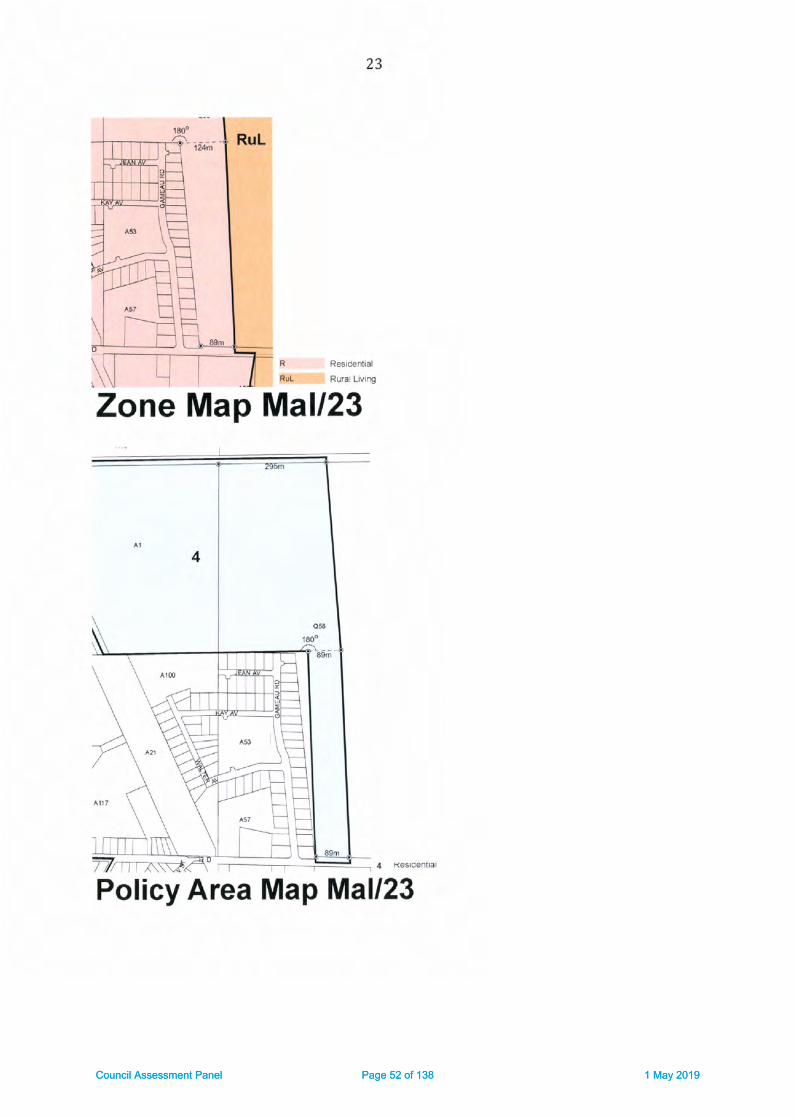
23
I R€aiderffql
I Rlral LMre
Zone Map Mall?3
I K€tErnlal
Policy Area Map Mal/23
Council Assessment Panel Page 52 of 138 1 May 2019Council Assessment Panel Page 52 of 138 1 May 2019

24
FroclnctI Two Wblls
Precinct Map Mal/23
I ; ; rr.i:!!^ ceneral Busftlire Risk
€iffiffi pxctuOeO area trom bushtire protectjon danning F'ovisbrE
Bushfire Protection AreaBPA Map Mal/{3
BUSHFIRE RISK
Page 53 of 138Council Assessment Panel Page 53 of 138 1 May 2019

Wnler Technoloty PtY Ltd t/a
Australian Water Environments
A8N 60 093 I /7 281
ACN:093 l// 2E3
l/198 Greenhrll Ro.d
td5lwood 5A 5063
Tclephonc 08 8378 gooo
trx 08 8357 It98E
www ;luslwalclcnv (om au
AustralianWATEREnvironments
Our Ref: P17126
Wednesday, 28 February 2018
Mr Andrew Gameau
Lot 235 Magnolia Boulevard
Two Wells SA 5501
Dear Andrew,
Re: Flood Advice lot Lot 235 Magnolio Boulevord, Two Wells
Thank you for the opportunity to provide flood advice for your Development Application 312/314/2016. As you
are aware, your property has been identified as being located within the Gawler River Floodplain as well as the
Light River Floodplain, and consequently the Gawler River Flood Hazard Policy Area. Council has asked that we
consider the flood hazard rating for the property in addition to our normal assessment based on the hazard zone
mapping reference specified in the Development (ie the 1993 hazard zone mapping)
our advice is being sought on appropriate locations and a suitable configuration for the proposed shed to manaBe
the impacts of flooding on it.
As Dart of our assessment we have investigated the impact to the land from flooding from the Gawler River and
Light River and we provide an assessment on:
. The expected flood depth, flow velocities, and hazards that exist for the existing allotment;
r Proximity to adjacent buildings, structures and properties and the impact of flooding; and
r Access conditions during a flood event (1 in 100 year ARI event) and warning times before inundation
Our recommendations are based on the outputs from floodplain mapPing for the Gawler River undertaken in 2014
and the Light River in 2010 as well as the flood hazard zone mapping conducted in 1993.
Assessment of Flood Depth and Flow Velocitiesyour property is one of the large (1 hectare or larger) Rural Living Allotments along the very eastern portion of the
Eden develoDment.
The flood mapping indicates that during a 1 in 100 year ARI flooding event of the Gawler River and/or LiSht River,
the sub.iect property and proposed area for the shed is subject to inundation. The flood depths on your properw
will typically range between 1.0 m up to 1.8 m.
Earthworks on your allotment were undertaken to ensure that your dwelling and undercover garaging of domestic
vehicles were located above the 1 in 100 year ARI flood level, irrespective of whether that flood is from the Light
River, or the Gawler River. The configuration of those earthworks ensures the house and any occupants in it would
be safe during a 1 in year ARI flood
Furthermore, Magnolia Boulevard is also located above the flood level and remains trafficable during a 1 in 100
year ARI flood. Safe access/egress to the west to Two Wells would be possible during a 1 in 100 year ARI flood.
A review of flood plain modelling results for the Light Rive r and the Gawler River indicates that the areas in question
become aflected by floodwaters for events around the 1in 50 year ARI flood from either river, but are n0t
Page 54 of 138Council Assessment Panel Page 54 of 138 1 May 2019

expected to be inundated (outside of the new drainage swale along the eastern boundary) in smaller events from
either river system,
Whilst the flood waters are relatively deep, they are expected to be of low velocity. typically less than 0.3 m/s. At
the proposed location of your shed the flood water velocity is expected to peak at approximately 0.20 m/s,
progressively becoming slower again to the west (towards your house).
our recommended location for your shed, alonE with a flood inundation map is provided in Figure 1,
We suggest the shed should be located towards the southern side of the property and set 7 m in from your
southern boundary. The shed could also be set 20 metres east of your existing house pad (but no further to the
east). Placing the shed in this location would put it within the H2 hazard zone rating as per the 1993 flood hazard
mapping.
L_l 0 - 0.r0
[email protected] - 0.25
FEffi o.zs -oso
Io.5o.1.ooI1m.i.soIi50-z50i=------lzso-s.m
FIGURE 1 FLOOD IXPTHS T IN IOO YEAi ARI FLOOD RISK
The relevant flood statistics at the centriod of the proposed shed location are provided in Table 1.
YABTE 1 GAWI.ER RIVERruGHT RIVER W€IG}ITED COMPOSIT€ 1 IN lOO YEAR ARI FI,OOO DTTAITT AT PROPOSCO sI{ED SITE
;low Velocity
(m/slFlow Depth (m)
{at centrold of shed}
Water Surface
Elevation {mAHD}(at centroid of shed)
Flood Harard
Ratlng
11993 mappint)
0.19 l.4l 72.57 Zone H2
PL7126 Lot 235 Flood Advice V1-2150228
Page 55 of 138Council Assessment Panel Page 55 of 138 1 May 2019

Assessment of Finished Floor LevelCouncil would normally require the finished floor level of a shed (not habitable) to be set above the 1 in X00 year
ARI flood level with a freeboard of 150mm. This is to prevent inundation of the shed and damage to its contents
during a flood. This approach is termed dry flood proofing. lt would require a flnished floor level of 12'72 mAHD.
We understand that this is not considered acceptable to you and hence you have Instructed us to advise you on
an altemative approach that provldes for a lower finished floor level whilst also ensuring that the damages to the
shed and its contents are mlnimised. lt is also important to consider any safety imPlications for you, your family
and guests to the property.
ln this instance we therefore consider there is merit in the appllcation of wet flood proofing measures. Whllst we
cannot guarantee that Council will accept our suggested approach, we consider it to be a practlcal means by which
the flood risk to vour proposed shed can be managed.
Application of Wet Flood Proofing MeasuresThe use of wet flood proofing techniques is an accepted method by many authorlties for managing non-residential
buildings In flood prone areas. (FEMA (2013)), We understand that Council has previously applied thls approach
in other nearby areas (such as the properties backing onto the railway reserve along Walter Avenue, Two Wells)
and as well as in some of its coastal settlements that are subject to sea water flooding.
There are also a number of practical beneflts in thls case which Include:
. SettinB the sheds at a lower level would help to ensure that they are left unattended during a flood and
people effectively evacuate the shed before surrounding flood waters become too deep and make it less
safe; and
o Establishing a lower floor level will reduce the volume of fill material to be placed in the floodplain and
further minimise any disruption to the movement of floodwaters.
There are also a number of obligations on you that adoptint a wet flood proofing approach requires. These
include:
r you will need to formally recognise the flood risk and accept liability for any damages to your property
or damages to others that flooding of the shed may cause. (This could be, for example, In the form of a
Land Management Agreement recognised on your title to ensure any future new landholders are also
aware of the flooding issues).
r The shed must not be habltable, nor is it used for that purpose.
r The shed will need to be designed by a suitably qualified designer to ensure that it can wlthstand partial
inundation, including;
o Foundations for the sheds must be able to maintain the necessary support for the structure
during a flood sltuatlon'
o The sections and areas of the shed potentially inundated should be constructed from flood
damage-resistant materials to reduce flood damage and facilitate cleanup. (For example: walls
could be constructed of steel frames and cladding (eg colour bond); any internal linings should
be of water resistant material, any timber work within the inundation depth should use marine
grade timber products, floors should be concrete slabs or course gravels (eg 15 mm gravel), or
if finer rubble material is used for floorings they should be cement treated)'
o Sheds to be contlgured to minimise damage from inundation (eg water is able to drain from
inside of shed and layout inside the shed enables simple cleaning of floor area etc.
o Shelving, any power outlets and any unsealed containers, or stored material subject to damage
by floodwaters within the shed to be set 150 mm above the 1 in 100 year ARI flood level (ie no
lower than t2.72 rr,AHD.
P77126 LotZ3s Flood Advlce V1 2 L80228
Page 56 of 138Council Assessment Panel Page 56 of 138 1 May 2019

o The shed designer certifying that these conditions are satisfied.
. Any large plant or equipment stored in the shed (et tractor, boat etc) that a susceptible to damate from
floodwaters are able to be readily relocated to high Sround out of the flood.
The above measures would promote the effective use ofwet flood proofing treatrnents to facilitate the installation
of a large shed / workshop and equipment on your property in a practical way.
Access requirementsAn important requirement for managing flood risk is the effective and safe access to and from a property.
Safe access to and from the dwelling on your property from Two Wells township should be possible during a 1 in
100 vear ARI flood event. However, consideration also needs to be given for the access to and from your house
to the shed during a flood.
The best practice guidelines (SCARM, 2O0O) provide guidance on the flood conditions that can be traversed by
wading (summarised in Table 2).
TABLE 2 : SCARM (1000) WAOING CRIT€R|A
Criteria Value
Able bodied adults maximum depth 1.2m (still water)
Able bodied adults maximum velociw 0.8m/s (shallow waterl
Notes: Surface, potholes, fences and stormwater drains
and visibilitv must also be taken into account
There has also been a more recent study which reviewed the available literature on wading in flood conditions
(Engineers Australia, 2010). This study defines the flow hazard regimes for children, adults and trained safety
workers based on the product of depth and velocity (DxV (m'z/s)). The maximum safe depth for adults is the
same as det€rmined by SCARM (2000). The recommendations from Engineers Australia (2010) are illustrated in
Figure 2.
Maxirnum DepthAdult {1.2m)
Maximum Depth ,
Child,en {0.5m)
fHarard CategoryiG.wlr' Rrycr lloodplar.M.pprnt)
f-l ro*
E-l uu,tu'^
ffil Brq,,
f e*,"^"
' Upper Limit "Moderate Hazard:DanBerous to some" fo. adults wadingUpper limit lor trained 5afety workers
. Upper limit "Low Hau ard" for adults wadinB andUpper limit for "SiSnificant Hazard danS€t lo most''fo, Children wadinB
I LJpper limit of "Low Halard" for Children wadinS
o veloclty (nrs) 1 2
lngineers Australla (2010lSatety crlt€ria for people
FTGURE 2 : ENGtN8ERS AUSTRAT-|A (2010) SAf€TY CRtTtRtA FOR PEOPLE lN FTOOO WATERS SUMMARIS€O ON FI-OOD HAZARD GRAPH
Engineers Australia (2010) also notes that loss of stability could occur in lower flows when adverse conditions
are encou ntered including:
. Bottom conditions: uneven, slippery, obstacles;
. Flow conditions: floating debris, low temperature, poor visibility, unsteady flow and flow aeration;
. Human subject: whether they are standing or moving, whether they are experienced and have had
training, what clothing and footwear they are wearing, their physical attributes in addition to heiSht and
mass {on which the experiments were based) as well as disability and psychological factors;
PL7l26 Lot235 Flood Advice Vl 2 180228
Page 57 of 138Council Assessment Panel Page 57 of 138 1 May 2019

r Other: strong wind, poor lighting the point at which the person feels unable to continue (i.e. when they fall
over or when they initially begin to slip).
Hence consideration needs to be given as to access arrangement between the dwelling and the shed.
Recommended Access Arrangements and Shed Finished Floor LevelOur review of the safe access requirements and recommended finished floor levels has regard to the above safe
access information in addition to the floodplain mapping information.
It also has regard to the fact that a flood warning system has been established for the Gawler River and a system
is presently being developed for the Light River. lt is anticipated that in either case there will be typically 24 hours
warning before a 1 In 1OO year event actually arrlves at the property. This should provide adequate time to avoid
accessing the shed or to evacuate from the shed, should that be necessary.
We recommend that the finished floor level ofthe shed be set no less than 510 mm above exlsting ground level,
ata level of 11.67 mAHD. This would result in a peak water depth of 900 mm in the shed during a 1 in 100 year
ARI flood. Power outlets and items susceptible to damage (as outlined above) would need to be set at the higher
elevation of 12.72 m AHD (le 150 mm above the flood level, and 1050 mm above the shed floor level).
We also recommend that an access track/driveway be constructed to provide access between the dwelling and
the shed. The access track should be set no less than 200 mm above the ground level, and it should follow the
slope of the terrain, This then provides a safe access route to and from the shed in the event that an individual is
either in the shed or needs to access it whilst the surrounding area i5 in flood but before the shed itself i5 actually
inundated. We would obviously recommend that the shed not be accessed when the sunounding area is
inundated, but the above arrangement would provide a degree of resilience because it will provide a gafe wading
depth for a child (0.5 m) lf they inadvertently are in the shed when the floor of the shed begins to be overtopped.
It also provides a practical access driveway for the shed that would remain dry and accessible at all times other
than when the area is subjected to a major flood. The track would need to ramp down and up from the dwelling
pad to the shed pad at either end. By following the terrain, the track will be gentling sloping up to the west and
thereby ensure that anyone leaving the shed later than recommended would be moving through progresslvely
shallower water.
lf any equipment is to be removed from shed, that should be done well before the before the access track is over
topped.
We also recommend that the alignment of the access track be approximatelY straight with the southern edge of
the track delineated by posts no further than ten metres apart or at each bend/ change in directlon of the track
(if closerl. The posts should be dearly vislble when the track is inundated, with the top of the post b€lng set at a
height no lower than 11,8 mAHD (le coinciding to the shed floor being 130 mm under water|.
In recommending the accegstrack and floor level elevations highlighted above we have had regard to the potential
impacts on the flow of flood waters and potential impacts on neighbouring properties. Whilst we consider that
these would be negligible given the very low flood water velocities, the above configurations, [including shed
location), should ensure that this is the case.
The recommended configuration is summarised the Table 3 below.
PL7L26 Lot2?5 Flood Advice V1 2 780228
Page 58 of 138Council Assessment Panel Page 58 of 138 1 May 2019

TABU 3 : REcoMlvlENDEo SHED AND ACTESS TRACK coNFIGURATION
Flnlshed Floor
Louel
Access track helght
Above Ground level
lm)
Wat€r Surface
Elevarlon (mAHD)
(at centrold of shed)
Lowest Elevatlon (mAHDl of
Po$,er Outlets and Flood Sensitive
Materlalr
11.67 mAHD o.2 L2.57 L2.72
We have also considered any requlrement for providing a flood path through the access track (eg via a pipe or box
culvert), We would not object to one being installed but do not consider that to be essential because the natural
slope ofthe ground willallow the area north and south ofthe track to drain towards the east. Furthermorq flood
velocities are low the height ofthe track is low when compared the maximum flood depth, and there are more
signiflcant hydraulic controlling features downstream of your property (eg Gawler Road). Hence, the track we
describe is not expected to create any signlficant adverse flooding impacts.
We trust that the above information will be of asslstance. Please do not hesitate to contact me should you require
any further clarifi cation.
Yours 5incerely,. a,/,/ /,
-11 r'L--.,4 '
,?Geoft Fisher
Regional General Manager, SA
Ausrallan Water Envltonments
Beferencest
Engineers Austrafia l21l:Ol Austrstlan Ratnfatt ond Runoff Revisian Project 70: Appropriote Sdfety Criterio forPeople Stoge 7 Report
FEMA (2013) Floodproofing Non-Residential Buildings. Published by US Department of Homeland Security, report
FEMA P-936, 2013.
SCARM (2000). Floodplaln Mdnagement in Austrolio. Best Proctice Principles and Guldelines. Agriculture and
Resource Management Council of Australia and New Zealand, Standing Committee on Agriculture and resource
Manatement Report no, 73.
Dlsclolmer:
This document is for the exclusive use of the client for which it was prepared and is not to be relied upon by any
other person. AWE has made reasonable efforts to ensure that the information provided is accurate but errors
and omissions can occur and circumstances can change from the time that the report or document was prepared,
Therefore, except for any liability that cannot be excluded by law, AWE excludes any liability for loss or damage,
direct or indirect, from any person relying (directly or indirectly) on opinions, forecasts, conclusions,
recommendations or other information in this report or document.
PI7I26 Lot235 Flood Advice Vl 2 L8O228
Page 59 of 138Council Assessment Panel Page 59 of 138 1 May 2019

Drtq Prerr€d - Tussd€y, 5 Jul2018
FYep.rsd by - John Rlco
Ord€r I PO Bo,\,16 P!r. Hillss-A.5m6Ph (08) 83{9 57il,lFax (08) 8349 ii222
t",Il--, I
'lItI
+ 61 :J.L F.
SIDE COLUMNS 3
GABLE END COLUMNS O
-Dpoubl. SlldlrE Door RAO pr.p mly RAo p|ep only PAD
-- lg?oo
LEFT HAND SIDE
Page 60 of 138Council Assessment Panel Page 60 of 138 1 May 2019

RIGHT HAND SIDE
Page 61 of 138Council Assessment Panel Page 61 of 138 1 May 2019

Cieated on l'hursday, 18 Apnl 2019
(A' *ELATDE PLATNS couNcrL
Adelarde Plaans Coun.iPO 8ox 18, lrla lala, SA 5502T: C8 8527 0200Fr 08 8527 2242
This advrce and/or Inforffatron is qiven for your private use only. The accuracy of the
advice and anforrnatron is mt qlaranteed and no responsrbilty is accepted by AdelaidePlarns Co!rKrl for any loqs or damaqe caus€d by reliance uFDn this advice dfld/orrnfonnal on, as a result of any e.rors, om ssion, incorrect description or state rent therern
or othenvise.
Page 62 of 138Council Assessment Panel Page 62 of 138 1 May 2019
southf rontlTu Greenhill Road Par kside 5A 5063
P 8172 1088 t [email protected] 96 007 344 191
Our Ref: 180o5-2-B
12 Aoril 2019
Rob VeitchGeneral Manager, Development and CommunityAdelaide Plains Council
PO Box 18
MALIALA SA 5502
Dear Rob
Gameau Shed (3121314120L61, Lot 235 Magnolia Boulevard, Two Wells - General
Advice on Flood Risk
Background
In November 2016 a Development Application was submitted to Adelaide Plains Council for theconstruction of an outbuilding at Lot 235 Magnolia Boulevard, Two Wells (DA 312/314/2016l. fheapplicant (Mr Andrew Gameau) is represented by Regional Planning Directions who have described
th€ proposed outbuilding as being a shed for domestic purposes with a floor area of 218m2 (21.8
metres long by 10 metres wide).
Lot 235 Magnolia Boulevard is a 1.4 hectare rural living allotment in Hickinbotham's Eden
Development, and is located within the floodplain of both the Gawler River and Light River. Incorrespondence dated 29 November 2015 Council requested that the applicant provide advice from
an independent hydrological engineer in relation to potential flood impacts, and on 20 August 2018
the applicant submitted an amended site plan and flood advice prepared by Australian WaterEnvironments {AWE) dated 28 February 2018.
AWE's flood advice for the subject land dated 28 February 2018 states that "A review ol floodplainmodelling results for the Light River ond the Gowler River indicdtes that the ateas in question become
olleded by floodwaterc lor events oround the 7 in 50 yeor ARI flood from either river, but ore not
expected to be inundoted (outside of the new drdinoge swole olong the eostern boundary) in smoller
events Jrom either river system".
As detaifed in the flood advice by AWE, "Council would normolly require the finished floor level of d
shed (not hobitdble) to be set obove the 7 in 7N yeor ARI flood level with a freeboard of 75omm.
This is to prevent inundotion of the shed ond domage to its contents during a flood. This approoch is
termed dry Ilood proofing" . However in this instance the applicant proposes a finished floor level forthe shed that is lower than the 1 in 100 year ARI flood level, together with a range of 'wet floodproofing' measures in an effort to manage the inherent flood risk at the site.
Southfront have been engaged by Adelaide Plains Council to undertake a risk based assessment of
the alternative flood proofing methods ('dry'versus'wet') as they relate to the proposed
outbuilding. The risk based assessment contained in this report has regard to the guidance offered
by Australian Rainfall and Runoff 2016 and the Australian Institute for Disaster Resilience's handbook
titled Monoging the Floodplain: A Guide to Best Proctice in Flood Risk Monogement in Australid
Page 63 of 138Council Assessment Panel Page 63 of 138 1 May 2019

(Australian Disaster Resilience Handbook 7, Third Edition, Australian Government Attorney-General's
Department,2017).
Documents supplied by Council
The following documents were supplied by Council and have been reviewed in preparing this advice:
) Two Wells Stormwotet Monagement Plon (AWE dated 10 April 2017);
D Eden Lorge Sheds Flood Exposure (AWE dated L4 July 2OL7l;
I Eden Estste, Two Wells - Shed in the Floodploin (PBA dated 20 J uly 2017);
I Outbuildings on the Gowler River Flood Plain - Two Wells (Kelledy Jones dated 22 September
ZOITll
I Flood Advice for Lot 235 Magnolio Boulevord, Two Wells (AWE dated 28 February 2018);
) Libefty (Two Wells) Detoiled Design Suppott - Eden Lorge Blocks, Additional site Fiiling ( wE
dated 29 May 2018);
I Proposal to erect a shed lot domestic purposes ot Lot 235 Magnolia Boulevord, Two Wells (DA
312/314/2015) (Regional Planning Directions dated 20 August 2018);
) Lot 235 Site Plan (Regional Planning Directions dated 8 october 2018);
> Response to meeting to discuss proposol to erect o shed in the Iloodploin ot Lot 235 Magnolid
Boulevord, Two Wells (DA 312/314/2016) (Regional Pla nning Directions dated 23 November
2018); and
> DA 312/314/2016 - Shed lor Domestic Purposes at Lot 235 Mdgn olio Boulevard, Two Wells
(Kelledy lones dated 3 April 2019).
Whilst we have reviewed the full range of background information provided by Council, this report
does not specifically address the planning and legal matters associated with the Development
Application. Rather this report provides a qualitative assessment of the relative merits of dry versus
wet flood proofing as they relate to the subject land,
Design Rainfall Terminology
In 2016 the Australian Rainfall and Runoff (ARR) guideline update was released. Theupdatewasthefirst major revision since ARR 1987 and was the result of an improved u nderstanding of the
Australian rainfall landscape, gained through collection and analysis of 30 years of additional rainfall
data from over 8,000 rainfall gauges across the nation.
The update also initiated a change in rainfall probability terminology whereby the use ofthe term
Average Recurrence lnterval (ARl) was replaced with the term Annual Exceedance Probabilityforinfrequent rainfall events. Annual Exceedance Probability (AEP) is the probability or likelihood of an
event occurring or being exceeded within any given year, expressed as a percentage.
For consistency with the background information provided by Council and the catchment-scale
studies that inform the assessment of flood risk at this locale (which p re-date the release of ARR
2015), we have elected to retain use of the term ARI in this report, noting the following forcom parative pu rposes:
> A 1in 20 year ARI event is equivalentto a5%AEP|
) A 1in 50 year ARI event is equivalent to a 2o/' AEP; and
) A 1 in 10O year ARI event is equivalent to a 1% AEP.
Page 64 of 138Council Assessment Panel Page 64 of 138 1 May 2019

A Risk Based Assessment of Dry versus Wet Flood Proofing
Australian Disaster Resilience Handbook 7 "oims to encourage those with responsibility lor monoging
flood risk to work towards ochieving best practice" and " improve community Jlood resilience using o
brood risk manogement hierarchy of ovoidance, minimisotion ond mitigation", wherein:
> Risk avoidance is achieved by limiting the likelihood or negating exposure to the flood hazard;
I Risk minimisation is achieved by mitigating the consequences of the flood hazard; and
> Residuaf risk, which Handbook 7 defines as "the risk remaining, in both existing and futuredevelopment oreos, ofter manogement meosures such as works, land-use plonning ond
development controls are implemented",is understood and accepted.
A dry flood proofing approach, envisaged by Genercl Section - Hozards - Principles oI Development
Control - 6(bJ of the Development Plan and typically applied to a development of this nature, wouldrequire the proposed outbuilding at Lot 235 Magnolia Boulevard to have a finished floor level of12.72mAHD, providing 150mm of freeboard to the peak 1 in 100 year ARI flood level at the site.
Freeboard is added to flood levels to provide reasonable certainty of achieving the desired level ofservice from setting a generalstandard or Defined Flood Event (Australian Disaster Resilience
Handbook 7). Under this scenario there would be residual flood risk to the outbuilding in eventsgreater than a 1 in 100 year ARl.
Rurol living Zone - Desired Chorocter Stdtement of the Adelaide Plains Council Development Plan
states that "Dwellings ond oncillory buildings ond strudures will be locoted ond designed to prevent
entry by floodwoterc. This will primdrily be ochieved through the raising of floor levels ahove the floodIevel, olthough olternotive solutions moy be oppropriate in limited circumstonces provided specific
flood proofing measures are included within any design ond construction". Onthisbasistheapplicant has proposed to construct the outbuilding with a finished floor level of 11.67mAH0, which
we understand would prevent the ingress of floodwaters in events up to "oround the 7 in 5Oyear
ARl" and result in inundation ofthe outbuilding during larger flood events, with a peak inundationdepth of 90ommduringa 1in l00yearARl event. U nder this scena rio there would be residual floodrisk to the outbuifding in events that are less than a 1in 100 year ARl. As outlined in the Flood Advice
for Lot 235 Magnolia Boulevard, Two Wells (AWE dated 28 February 2018) the applicant has
proposed additional wet flood proofing measures to assist in managing the residualflood risk.
Flood risk can be managed by limiting the likelihood and/or consequences of a flood event. From
ARR 2016 Chapter 5; Flood risk is expressed in terms oJ combinotions ofthe likelihood ol events(generolly measured in tetms of Annuol Exceedonce Probobility (AEP)) ond the severity d theconsequences of the event. Risk is higher the more frequently on oreo is exposed to the some
consequence ot when the some frequency of event hos higher consequences. Byenablingmorefrequent inundation of the proposed outbuilding at Lot 235 Magnolia Boulevard a wet flood proofing
approach would inherently result in a higher level of flood risk than for a dry flood proofing
approa cn.
In considering this Development Application Council should also assess whether the suite ofadditional wet flood proofing measures proposed by the applicant would mitigate the consequences
of a flood event to an acceptable level for the current occupiers of the land, guests to the property,
and the community at large; both now and in the future. In observing that "we connot guorontee
thot Council will occept our suggested opprooch" , it is our interpretation that the author of theapplicant's flood advice has foreshadowed Council's duty of care in determining whether this isindeed the case.
The discussion below provides an overview ofthe risks associated with key aspects ofthe applicant'sproposed wet flood proofing approach.
Page 65 of 138Council Assessment Panel Page 65 of 138 1 May 2019

Filling in the Floodpla in
A dry flood proofing approach would require filling to a height of approximately 1.5 metres withinthe floodplain to achieve a finished floor level of 12.72mAHD for the proposed outbuilding at Lot 235
Magnolia Boulevard.
As a generalrule filling within a floodplain has the potential to locally increase flood levels, whichmay adversely impact adjoining properties and/or existing infrastructure. The applicant's floodadvice describes a practical benefit to the wet flood proofing method as " Estoblishing o lower floorlevel will reduce the volume of Jill moteriol to he placed in the foodploin ond further minimise any
disruption to the movement offloodwaters",
The impact of filling within a floodplain is typically assessed by incorporating the proposed fillenvelopes into a floodplain model and comparing the results to the base case. Such an exercise was
performed by AWE in May 2018 in support of the extended site filling along the western portion of223 to 235 Magnolia Boulevard (as part of a separate Category 3 Development Application). This
hydraulic modef fing determined that "thele will be no signilicant chonge in flood risk in relotion to
flood levels, velocities ond hozods as d rcsult of the additionol lill material" .
Given this finding, the floodplain model could be further updated to assess the impact of filling toachieve a dry flood proofing approach to the proposed outbuilding at Lot 235 Magnolia Boulevard, as
this would determine whether establishing a lower floor level for the proposed outbuilding offers a
genuine benefit.
Current and Future Use of Outbuilding
Austrafian Disaster Resilience Handbook 7 defines a habitable room as "ln o residential situotion, d
Iiving or working area, such os a lounge room, dining room, rumpus room, kitchen, bedroom orworkroom. ln on industriol or commercial situation, it refers to dn oreo used for olfices or to store
valuoble possessions susceptible to flood domoge in the event oI o flood" .
The Development Application and supporting documentation suggests that the proposed outbuilding"will not be hobitoble", while also describing the various uses of the proposed outbuilding as for the
"stordge ol o coravon, boat, twotrdilers, o utility, o slosher/mower plus other personal items. There
will olso be a workshop area for ony projects undertoken by my Clients around the home" ,
Based on this description it would be reasonable to conclude that the proposed outbuilding would be
habitable as defined by Australian Disaster Resilience Handbook 7, on the basis that it is intended tobe used as a "workroom" and for the storage ofa range ofvaluable possessions.
Electricity
The most serious consequence of flooding is the risk of fatality to individuals who may interact withhazardous flood situations. Australian Disaster Resilience Handbook 7 identifies electrocution as a
cause of fatalities during floods. The a pplicant's proposed wet flood proofing methods requlre" power outlets ond dny unsealed contoiners, or stored moteriol subject to domage by floodwoterswithin the shed to be set 751mm obove the 1 in 7oo yedr ARI flood level" . lrrespective of whateveragreement may be put in place between Council and the currenVfuture landowner to assign liabilityfor damages to property and persons caused by flooding, the potential for death or serious injuryresulting from failure to comply with these requirements is a broader public safety issue for Council
consideration.
Failure to comply with the proposed wet flood proofing requirements may result incidentally duringday to day use of the outbuilding, such as persons leaving mains powered equipment on the floor,
Page 66 of 138Council Assessment Panel Page 66 of 138 1 May 2019
shelves or benches that are below the 1 in 100 year ARI flood level. There is also a possibility thatcurrent/future landowners install power outlets at a level below th€ 1 in 1OO year ARI flood level.
Access Provisions and Flood Warning Times
The applicant's flood advice provides a comprehensive assessment of safe access provisions between
the dwef ling and the shed, and highlights th at " a flood warning system hos been estdhlished for the
Gawler River dnd d system is presently being developed for the Light River. lt is dnticipoted thot in
either cose there witl be typically 24 hours warning belore o 1 in 7M year event actuolly orrives ot theproperty. This should provide adequate time to avoid occessing the shed or to evocuote from the
shed, should that prove necessory'' ,
Having regard to AWE's characterisation of the floodplain behaviour at this locale, it is expected thatthe applicant's proposed safe access provisions would be effedive in facilitating the evacuation ofpersons from the proposed outbuilding, provided that the safe access provisions are used as
intended, and that all current and future occupants ofthe land (including rental tenants, visitors,
house sitters etc! are made aware of and subscribe to the flood warning system.
However there are a number of practical matters that should be considered by Council in
determining whetherthe proposed safe access provisions and flood warning system would prove
effective in mitigating the risk of property damage, including:
) The potential consequences of the property being unattended during a flood event {eg. when the
occupa nts are away on holiday);
) The adequacy of the typical 24 hour wa rn ing time in enabling the occupants to im plement a n
evacuation plan for the valuable possessions that are proposed to be stored within the
outbuilding;
) Whether a sufficient area of "high ground" exists on the property to enable the evacuation of the
valuable possessions that are proposed to be stored within the outbuilding; and
> Whether the proposed flood warning system and associated evacuation plan would be
acceptable to any third parties who have an interest in vehicles or equipment or goods that are
proposed to be stored within the outbuilding (eg. financiers, purchasers of equipment or goods).
Based on the above circumstances it would be reasonable to conclude that a high risk of property
damage would remain under a wet flood proofing approach.
Water Level Equalisation and Outbuilding Security
The wet flood proofing measures outlined in the report titled Eden Large Sheds Flood Exposure (AWE
dated 14 Jufy 2017) included that " Provision is made dlong the northern and southern side of eoch
shed Iot two flood flaps on eoch side of the building (eoch o minimum of 0.5% qthe inundated ared
or 7.0m wide by o.jm high, which ever isthe gredtet)to opercte freely ond ollow fot wdter levelsto
equolise within ond outside oI the shed in times of o flood and olso ollow water to poss through the
shed' . Flap Zates are a widely accepted method of achieving water level equalisation in stormwater
management systems.
The applicant's subsequent flood advice did not include the provision for flap gates and therefore itremains unclear how the design ofthe proposed outbuilding would achieve water level equalisation.
It is also noted that flap gates are not typically used in circumstances where their operation can
facilitate unauthorised access to valuable private property.
Page 67 of 138Council Assessment Panel Page 67 of 138 1 May 2019

Summary
The applicant,s proposed wet flood proofing approach, while not without merit, would lower the
threshold at which the proposed outbuilding would be subject to a residualflood risk to less than a 1
in 100 year ARI event. The proposed wet flood proofing approach also carries a higher risk, through
the potential circumstances that could give rise to an increased likelihood and/or consequence of
flood damage, than a conventional dry flood proofing approach'
It is therefore recommended that Council require a dry flood proofing approach to be adopted forthe proposed outbuilding at Lot 235 Magnolia Boulevard, Two wells (DA 312/314/2016).
Please do not hesitate to call me on 8172 1088 if you require any further information regarding the
above.
Brett ShuttleworthSenior Engineer
Yours sincerely
6ft'd-*t
Page 68 of 138Council Assessment Panel Page 68 of 138 1 May 2019

Council Assessment Panel Page 69 of 138 1 May 2019

Page 70 of 138Council Assessment Panel Page 70 of 138 1 May 2019

Page 71 of 138Council Assessment Panel Page 71 of 138 1 May 2019

Page 72 of 138Council Assessment Panel Page 72 of 138 1 May 2019

Page 73 of 138Council Assessment Panel Page 73 of 138 1 May 2019

Page 74 of 138Council Assessment Panel Page 74 of 138 1 May 2019

Page 75 of 138Council Assessment Panel Page 75 of 138 1 May 2019

Page 76 of 138Council Assessment Panel Page 76 of 138 1 May 2019

CDAP Agenda 20/06/09
CAP Item 7.2, DA 312/065/2017 – Mr Alex Lange
APPLICATION NO. 312/065/2017
APPLICANT Mr Alex Lange
DEVELOPMENT PROPOSAL Construction of a Domestic Outbuilding and associated earthworks
LODGEMENT DATE 22 March 2017
LOCATION Lot 233 (DP113928) Magnolia Boulevard, TWO WELLS
ZONE Rural Living and Precinct 3 Two Wells
NATURE OF DEVELOPMENT Merit
PUBLIC NOTIFICATION Category 1
ASSESSING OFFICER Trevor V White – Planning Consultant
REFERRALS No Referrals under Schedule 8 of the Development Regulations 2008
DEVELOPMENT PLAN VERSION Consolidated 21 April 2016
RECOMMENDATION Development Plan Consent to be REFUSED
BACKGROUND: A Development Application was lodged by the applicant with the Adelaide Plains Council on 22 March 2017. The site of development (‘subject land’) is located within what is defined as the ‘Eden’ development being undertaken by the Hickinbotham Group. The ‘subject land’ is contained within the Rural Living Zone contained within the Mallala Council Development Plan 21 April 2016 – consolidation.
A Development Application, 312/256/2016 for the construction of a single storey detached dwelling on the ‘subject land’ received Development Plan Consent on 3 November 2016.
As part of the land purchase process, Council is required to issue a Section 7 Statement under the Land and Business (Sale and Conveyancing) Act 1994. The purpose of the statement under Section 7 of this Act is to put land purchasers on notice to particular concerns relating to the land to be acquired. Therefore, considering the ‘subject land’ is entirely contained within the Rural Living Zone of the Hickinbotham ‘Eden’ development it is fair to state that the applicant would have been advised that the allotment was subjected to varying levels of flood inundation, which meant flood mitigation action would need to be undertaken to satisfy zone policy provisions associated with various forms of development on the ‘subject land’.
As part of the assessment process, this report will undertake, an assessment of the actual outbuilding and associated earthworks (inundation measures) located in an area that is subjected to flood inundation, but also whether the use of ‘wet flood proofing techniques’ satisfies the policy provisions within the General Modules and Zone provision regarding mitigating the impacts of a 1 in 100-year ARI flood event.
The term ‘wet flood proofing’ is a design method that allows floodwaters to move through an enclosed building, such as a domestic outbuilding and then re-access the building when floodwaters recede. The argument put forward for allowing ‘wet flood proofing’ is that the finished floor level (FFL) of the proposed outbuilding can be built below the 1 in 100-year floodplain level. A report by AWE Hydrological Engineers suggested that openings could be placed in the walls of the building, near ground level, to allow water to pass through the building, thus reducing the pressure on the walls of the building, created by the flood waters. However, items such as electrical panels and outlets would need to be placed above the 1 in 100-year flood level, however this method does not prevent damage to the building from objects moving in the floodwaters.
The practical benefits of wet flood proofing as defined in AWE advice are listed below
Setting the sheds at a lower level would help to ensure that they are left unattended during a flood and people effectively evacuate the shed before surrounding flood waters become too deep and make it less safe; and
Page 77 of 138Council Assessment Panel Page 77 of 138 1 May 2019

CAP Agenda 01/05/2019
Establishing a lower level will reduce the volume of fill material to be placed in the floodplain and further minimise any disruption to the movement of flood waters.
However, the AWE advice also identifies several obligations that the landowner would need to adopt for the implementation of a ‘wet flood proofing measure’, those being:
The landowner would need to formally recognise the flood risk and accept liability for any damages to their property or damages to others that flooding of the shed may cause.
The shed must not be habitable, nor used for that purpose;
The domestic outbuilding would need to be designed by a suitably qualified designer to ensure that the building can withstand partial inundation, including:
Foundations of the building must be able to maintain the necessary support for the structure during the flood situation;
The section and areas of the building potentially inundated should be constructed from flood damage resistant materials to reduce flood damage and facilitate clean-up (For example: walls could be constructed of steel frames and cladding (eg colorbond); any internal linings should be of water resistant material, any timber within the inundation depth should use marine grade timber products, floors should be concrete slabs or course gravel (eg 15mm gravel) or if finer rubble material is used for floorings they should be cement treated.
Sheds to be configured to minimise damage from inundation (eg water able to drain from inside the building and layout inside the building enables simple clearing of the floor area;
Shelving and power outlets and any unsealed containers, or stored material subject to damage by floodwaters within the building to be set 150mm above the 1 in 100-year flood level (ie no lower than 12.47m AHD;
The building designer certifying that these conditions are satisfied; and
Any large plant or equipment stored in the building (eg tractors, boats etc) that are susceptible to damage from floodwaters are to be readily relocated to high ground out of the flood.
The AWE Report suggests that the above measures would promote the effective use of the wet flood proofing treatments to facilitate the installation of a large building/workshop and equipment on the ‘subject land’ in a practical manner.
The more relevant question relates to the size of the existing building platforms, as to whether 900m² is of adequate size and shape to cater for rural living allotments where not all buildings are going to be grouped together, considering all of the rural living allotments within this development are subjected to varying levels of flood inundation.
The term ‘dry floodproofing’ is a design technique where the finished floor level (FFL) of the proposed built form (dwellings and outbuildings) are constructed above the 1 in 100-year floodplain level, thus making the building waterproof and not subjected to floodwater pressure on the building.
As part of the applicant’s documentation submitted by AWE to support the concept of ‘wet flood proofing’, Council have engaged the professional services of Southfront (Hydrological Engineers) to undertake a risk based assessment of the alternative flood proofing methods (‘dry’ versus ‘wet’) as they relate to the proposed outbuilding.
Southfront took the opportunity to review the full range of background information provided by Council before preparing their report and excluding any planning or legal matters associated with the Development Application. The independent report provides a qualitative assessment of the relative merits of dry versus wet flood proofing as they relate to the subject land.
After considering the following aspects listed below:
Filling in the floodplain; Current and Future Use of the Outbuilding; Electricity; Access Provisions and Flood Warning Times; Water Level Equalisation and Outbuilding Security
The independent advice concluded that the ‘wet flood proofing’ approach was not without some merit; it would however lower the threshold at which the proposed outbuilding would be subject to a residual flood risk to less than a 1 in 100-year ARI event. The proposed ‘wet flood proofing’ approach also carries a higher
Page 78 of 138Council Assessment Panel Page 78 of 138 1 May 2019

CAP Agenda 01/05/2019
risk, through the potential circumstances that could give rise to an increased likelihood and/or consequence of flood damage, than a conventional dry flood proofing method and therefore recommended Council require a dry flood proofing approach be adopted for the proposed outbuilding.
In addition to the documentation lodged as part of the development application the following additional information has also been provided to Council for consideration:
Planning Statement December 2018 – prepared by the applicant’s planning consultant; and
A Flood Report December 2017 – prepared by Australian Water Environment (AWE)
The question of who would be liable for any damages to the building, items and fixtures contained within the building, should the building be affected by flood inundation has been raised with the applicant offering a number of options to reduce the risk to Council, should the proposal be granted Development Plan Consent. The options offered are listed below:
Preparation of an Emergency Management Plan (EMP) containing early warning mechanisms and evacuation procedures – which could be required by condition;
Condition requiring tenants or future owners to comply with EMP; Owner to sign waiver confirming acceptance of liability; Disclaimer in form of note on consent; and Limit approval to current applicant with subsequent land owners submitting new applications.
On receipt of the above options, Council sought legal advice in regards to the effectiveness of the above measures in discharging liability from Council in the event that the shed (or property within) is damaged as a result of Council’s Approval of a finished floor level (FFL) below the predicted flood level.
The legal advice highlighted the relevant provisions of Council’s Development Plan:
development should minimise the risks to safety and property of flooding from the Gawler River, Salt Creek and the Light River;
dwellings and ancillary buildings and structures will be located and designed to prevent entry by floodwaters. This will primarily be achieved through the raising of floor levels above the flood level, although alternative solutions may be appropriate in limited circumstances provided specific flood proofing measures are included within any design and constructions;
all dwellings, outbuildings and fences should be designed and sited in a matter that does not result in flood waters increasing the potential hazard risk to public safety and persons during a flood event;
development should be excluded from areas that are vulnerable to, and cannot be adequately and effectively protected from, the risk of hazards;
there should not be any significant interference with natural processes in order to reduce the exposure of development to the risk of natural hazards;
development should not occur on land where the risk of flooding is likely to be harmful to safety or damage property;
development in the GRFP should be designed and sited to minimise the flood impacts that occur within Flood Zone Areas 1, 2 and 3;
development should not be undertaken in areas liable to inundation by tidal, drainage or flood waters unless the buildings are designed and constructed to prevent the entry of floodwaters in a 1 in 100-year flood event;
finished floor levels for outbuildings should be a minimum of 150mm above the height of the 1 in 100-year flood levels or 150mm above the natural surface level whichever is the greater.
The advice also states that from the issues highlighted above it is apparent that there is a clear presumption against development in flood prone areas and that the primary focus of the Development Plan is preventing the entry of flood waters into buildings and structures.
The advice further have outlined in detail but acknowledges that Council, as a public authority, owes common law duties of care to individuals when exercising its statutory powers.
In addition the advice also pointed out that as the land is in the Gawler River Flood Plain (GRFP) the applicant should already have an EMP which contains early warning mechanism and evacuation procedures. It is therefore our advice that it would be inappropriate to impose a condition requiring the preparation of an EMP with the intention that the same would aid in discharging the Council’s duty of care, subsequent to it granting DPC to a development that was contrary to the provisions of the Development Plan. Similarly, the
Page 79 of 138 1 May 2019Council Assessment Panel Page 79 of 138 1 May 2019

CAP Agenda 01/05/2019
advice considers it unlikely that the Council would be able to prove that the EMP was not complied with and subsequently seek to enforce the same.
They have also suggested that even where waivers are fully agreed by all parties, they are often read down by the Courts, particularly where they purport to limit the liability of a statutory or Government authority. They consider, given the relevant provisions of the Development Plan which speak against approving the DA, it is highly likely that the waiver would not serve to protect the Council in any future action against it arising from the flooding of the Land.
Advice was also provided in relation to Limiting Development Approval.
DPC’s and other forms of development authorisations cannot be limited to a single person except in the rarest and most extenuating circumstances. We do not consider such a measure to be appropriate in these circumstances.
Even if it were possible to limit a development authorisation to a single person in these circumstances, an attempt to do so would be unlawful. This is because the limitation is only sought to circumvent the fact that the DA, as assessed against the Development Plan should be refused.
As part of the Hickinbotham ‘Eden’ development within the Rural Living Zone and Precinct 3 Two Wells, part of the development involved the construction of a 900m² building platform that was initiated by the developer and was approved by both Council’s Engineering and Planning staff.
Whilst different terminology has been used by the developer to describe the building platforms (eg residential earthworks, rural living earthworks platform, block filling etc), the intention of the building platforms was that the finished level of the platforms be equal to the level of the 1 in 100 year ARI flood level, with the finished floor level of dwellings being constructed 300mm above the platform level and 150mm above the platform level in the case of domestic outbuildings within the Gawler River Flood Plain.
SITE AND LOCALITY: The ‘subject land’ is described as Allotment 233 (D113928) Hundred of Port Gawler, 6 Magnolia Boulevard at Two Wells and contained within Certificate of Title Volume 6181 Folio 173.
The ‘subject land’ has a total area of 1.213 hectares, with a consolidated frontage to Magnolia Boulevard and Secomb Road of 55.16 metres and 50.010 metres respectively. The allotment has varying levels of flood inundation associated with a 1 in 100-year ARI flood event. The ‘subject land’ is entirely contained within the Rural Living Zone and Precinct 3 Two Wells and is surrounded by general farming land to the east and south of the site, residential properties to the west with other rural living allotments to the north.
PROPOSAL: The applicant seeks Development Plan Consent for the construction of a domestic outbuilding measuring 15.200 metres x 12.015 metres x 4.877 metre wall height. The proposed walls and roof of the proposed building will be clad in prepainted steel sheeting with an external finish that is commensurate with the colour scheme approved for the single storey detached dwelling approved on 3 November 2016 via DA 312/256/2016. The proposed building will be located some 11.000 metres from the northern boundary of the allotment and located behind the approved dwelling, which locates the proposed building in Hazard Zone 2. The allotments are within the area designated as the Gawler River Flood Plain (GRFP), which contains 3 Hazard Zone categories:
Hazard Zone 1 (wading becomes unsafe) Hazard Zone 2 (vehicles become unstable); and Hazard Zone 3 (vehicles and wading unsafe).
Located on the western aspect of the proposed building will be a PA door and double sliding doors measuring approximately 4.500 metres high. The proposal is not only for the construction of the building but also the extent of earthworks on which the building would be erected, taking into consideration the impact on the building and earthworks on a 1 in 100-year ARI flood event. The proposed building will be located 26.000 metres from the building platform associated with the existing single storey detached dwelling.
Council Assessment Panel Page 80 of 138 1 May 2019Council Assessment Panel Page 80 of 138 1 May 2019

CAP Agenda 01/05/2019
NATURE OF DEVELOPMENT AND CLASSIFICATION: The applicant seeks consent to construct a domestic outbuilding measuring 15.200 metres x 12.015 metres wide x 4.877 metre wall height, located within the Rural Living Zone and Precinct 3 Two Wells of the Mallala Council Development Plan (21 April 2016 – consolidation) which supports the construction of a single storey detached dwelling and associated outbuildings.
As part of the Hickinbotham ‘Eden’ development within the Rural Living Zone and Precinct 3 Two Wells, part of the development involved the construction of a 900m² building platform that was initiated by the developer and was approved by both Council’s Engineering and Planning staff.
Whilst different terminology has been used by the developer to describe the building platforms (eg residential earthworks, rural living earthworks platform, block filling etc), the intention of the building platforms was that the finished level of the platforms be equal to the level of the 1 in 100 year ARI flood plan, with the finished floor level of dwellings being constructed 300mm above the platform level and 150mm above the platform level in the case of domestic outbuildings within the Gawler River Flood Plain.
The original location proposed by the applicant for the domestic outbuilding was indicated 55.000 metres from the rear of the existing single storey detached dwelling and 5.000 metres from the northern boundary of the allotment. This original location would have placed the proposed outbuilding within the Hazard Zone 3 of the Gawler River Flood Plain and as such the proposed development would have been deemed to be a ‘non-complying’ form of development.
The applicant, with the assistance of Council planning staff agreed to a new location that would place the proposed building 26.000 metres from the rear of the existing dwelling and within Hazard Zone 2 of the Gawler River Flood Plain and therefore the application would be assessed on ‘merit’ rather than a ‘non-complying’ for of development. The proposed building will also be located 11.000 metres from the northern boundary of the allotment, with the access to the proposed building also being located on the northern aspect of the existing building platform (refer to agreed Site Plan attached).
Development Plan Consent has been granted for the construction of a single storey detached building via DA 312/256/2016, with that approval being granted on 3 November 2016.
Reference has been made to the Procedural Matters contained within the Rural Living Zone, which states the following in relation to buildings and structures within the Gawler River Flood Plain:
The proposal fails to comply with the prescribed forms of development listed in Schedule 4 of the Development Regulations 2008 and as such cannot be deemed to be a complying form of development.
The non-complying form of development within the zone states the following:
Form of development Exceptions
Building or structure within the Gawler River Flood Plain, as shown on the Overlay Maps – Development Constraints Maps
Except where: a) It facilitates the provision of public infrastructure
for flood mitigation or flood management purposes
b) The total floor area of the buildings or structures measure less than 8 percent of the area of the allotment within Hazard Zone 1 and/or Hazard Zone 2 of the Gawler River Flood Plain as shown on the Gawler River Flood Hazard map – GRO Map No. 238/1993
As the total area of the approved dwelling and proposed domestic outbuilding is less than 8 percent of the total floor area of the allotment, then the proposal for the construction of a domestic outbuilding in association with an approved dwelling is not deemed to be a ‘non-complying’ form of development and as such will be assessed on ‘merit’.
Public Notification: Reference has been made to the Rural Living Zone public notification categories where Council’s Development Plan is silent on the category of public notification for the construction of a domestic outbuilding associated with an approved or existing dwelling:
Reference has therefore been made to Schedule 9, Part 1 of the Development Regulations 2008, which states the following:
Council Assessment Panel Page 81 of 138 1 May 2019Council Assessment Panel Page 81 of 138 1 May 2019

CAP Agenda 01/05/2019
Part 1 – Category 1 development 2 Except where the development is classified as non-complying under the relevant Development Plan, any
development which comprises—
(d) the construction of (or of any combination of) a carport, garage, shed, pergola, verandah, fence, swimming pool, spa pool or outbuilding if it will be ancillary to a dwelling; or
In summary, the proposal is for the construction of a domestic outbuilding and associated earthworks which is ancillary to a dwelling that was approved on 3 November 2016 via DA 312/256/2016 and is therefore not a ‘non-complying’ form of development, then the proposal will be assessed as a Category 1 kind of development for the purposes of public notification in accordance with Part 1, 2(d) of Schedule 9 of the Development Regulations 2008.
AGENCY REFERRALS: There were no requirements under Schedule 8, of the Development Regulations 2008 for referral of the application to any of the Government Agencies.
The ‘subject land’ is located within the General Bush Fire Risk Area as depicted on BPA Map Mal/13 of Council’s Development Plan, consolidated 21 April 2016 and as such there is no mandatory referral to the CFS under Schedule 8 of the Development Regulations 2008.
ASSESSMENT: In assessing the proposal for the construction of a domestic outbuilding and associated earthworks located within the Rural Living Zone and Precinct 3 Two Wells the proposal will be considered against the relevant policy provisions contained within the General Modules, Zone and Precinct policy provisions contained within Council’s Development Plan (21 April 2016 – consolidation).
GENERAL MODULES PROVISIONS:
Design and Appearance: Objective 1 Development of a high architectural standard that responds to and reinforces positive aspects of
the local environment and built form.
PDC 7 The external walls and roofs of buildings should not incorporate highly reflective materials which will result in glare to neighbouring properties or drivers.
PDC 20 Sheds and garages, other than stables, kennels and animal pens, should not be of a size that will visually dominate surrounding dwellings.
The proposed domestic outbuilding has been architecturally designed by Olympic Industries who are one of the major long standing shed building manufacturers in South Australia.
The proposed outbuilding will be clad in pre-painted steel sheet cladding with the colour scheme of the proposed building being commensurate with the colour scheme approved for the existing dwelling. From the information provided by Council the applicant is yet to decide on the final colour scheme. Council requires the external finish of the building to be non-reflective to ensure there is no glare impact on the neighbouring properties or users of adjoining public roads. The proposed domestic outbuilding will be 15.200 metres x 12.015 metres x 4.877 metre wall height, which equates to a total floor area of 182.63m², which is not considered to be a dominant feature on the ‘subject land’ when the area of the allotment (larger allotment) which is equal to or greater than 1 hectare.
In summary, the proposed outbuilding is an appropriate size for the intended use within the rural living zone.
Hazards: Desired Character Statement:
Dwellings and ancillary buildings and structures will be located and designed to prevent entry by floodwaters. This will primarily be achieved through the raising of floor levels above the flood level, although alternative solutions may be appropriate in limited circumstances provided specific flood proofing measures are included within any design and construction.
The desired character statement provides a clear message that both dwellings and ancillary structures are to be designed to prevent the entry of floodwaters. It also suggests under limited circumstances an alternative solution may be considered.
Council Assessment Panel Page 82 of 138 1 May 2019Council Assessment Panel Page 82 of 138 1 May 2019

CAP Agenda 01/05/2019
The AWE report presented several practical benefits supporting the concept of ‘wet flood proofing’ which have been listed earlier in the report. Council took the opportunity to seek independent hydrological advice (provided by ‘Southfront’) who undertook a risk-based assessment of the alternative flood proofing method (‘dry’ versus ‘wet’) as they relate to the proposed outbuilding.
The ‘Southfront’ report concluded by stating the following:
‘The applicant’s proposed wet flood proofing approach, while not without merit, would lower the threshold at which the proposed outbuilding would be subject to a residual flood risk to less than a 1 in 100-year ARI event. The proposed wet flood proofing approach also carries a higher risk, through the potential circumstances that could give rise to an increased likelihood and/or consequence of flood damage, than a conventional dry flood proofing approach’.
‘It is therefore recommended that Council require a dry flood proofing approach to be adopted for the proposed outbuilding at Lot 233 Magnolia Boulevard, Two Wells’.
Objective 6 Development in the Gawler River Flood Plain which is designed and sited to minimize the varying potential flood impacts that occur within ‘Flood Hazard Zone 1’, ‘Flood Hazard Zone 2’ or ‘Flood Hazard Zone 3’, as shown on the Gawler River Flood Hazard Map - GRO Map No. 238/1993.
PDC 4 Development should not occur on land where the risk of flooding is likely to be harmful to safety or damage property.
PDC 5 Development should not be undertaken in areas liable to inundation by tidal, drainage or flood waters unless the development can achieve all of the following:
(a) it is developed with a public stormwater system capable of catering for a 1-in-100-year average return interval flood event
(b) buildings are designed and constructed to prevent the entry of floodwaters in a 1-in-100-year average return interval flood event.
PDC 6 Within the ‘Gawler River Flood Plain’ as shown on the Overlay Maps – Development Constraints:
(a) the finished floor level for dwellings, buildings for the keeping of animals, and gully traps should be a minimum of 300 millimetres above the height of a 1-in-100-year average return interval flood event of the Gawler River or natural surface level, whichever is greater
(b) the finished floor level for outbuildings should be a minimum of 150 millimetres above the height of a 1-in-100-year average return interval flood event of the Gawler River or natural surface level, whichever is greater
(c) allotments should contain sufficient area to accommodate the uses for which the land is intended
(d) filling for purposes ancillary to or associated with an approved use of land should be to a maximum of 100 millimetres above natural ground level
(e) filling required to raise the finished floor level of a building should not extend more than 10 metres beyond the external walls of that building
(f) driveways should be: (i) filled to a maximum of 100 millimetres above natural ground level (ii) no more than 5 metres wide.
PDC 7 Development, including earthworks associated with development, should not do any of the following: (a) impede the flow of floodwaters through the land or other surrounding land (b) increase the potential hazard risk to public safety of persons during a flood event (c) aggravate the potential for erosion or siltation or lead to the destruction of vegetation during a
flood (d) cause any adverse effect on the floodway function (e) increase the risk of flooding of other land (f) obstruct a watercourse.
Objective 6 applies to all development within the Adelaide Plains Council Area where development is proposed in Flood Hazard Zones 1, 2 or 3 as shown on the Gawler River Flood Hazard Map – GRO Map No 238/1993. The intent of the objective can be used to support the argument for both ‘wet’ and ‘dry’ floodproofing and is unclear as to what design and location techniques need to be employed to minimise potential flood impacts.
Council Assessment Panel Page 83 of 138 1 May 2019Council Assessment Panel Page 83 of 138 1 May 2019

CAP Agenda 01/05/2019
In a Planning Report prepared by Philip Brunning & Associates Pty Ltd, Town Planning Consultants, and sent to Council’s CEO, it suggested that ‘wet flood proofing measures’ is an accepted method by many authorities for managing non-residential buildings in flood prone areas. However, the report failed to provide any examples where this method had been adopted in South Australia.
Over a period of time since the lodgement of the development application in March 2017 the applicant has offered a number of options such as the preparation of an Emergency Management Plan (EMP) containing early warning mechanisms and evacuation procedures – which could be required by condition, condition(s) requiring tenants or future owners to comply with EMP, owner to sign waiver confirming acceptance of liability, disclaimer in form of note on consent; and limiting approval to current applicant with subsequent land owners submitting new applications in order to discharge liability from Council in the event that the shed (or property within) is damaged as a result of Council’s Approval of finished floor level (FFL) below the predicted flood level.
It was asked that legal advice be given in relation to the options suggested by the applicant to discharge liability from Council. The advice received by Council from their legal counsel overwhelmingly concluded that the assurances proposed by the Applicant did not alleviate the planning issues concerning the outbuilding or otherwise appropriately discharge the liability, and thus the duty of care, that attaches to the Council in these circumstances, thus suggesting the application should be refused.
PDC 4 listed above is quite clear and defined in that development should not occur on land where the risk of flooding is likely to be harmful to safety or damage property.
PDC 5(b) further reinforces the argument for ‘dry flood proofing’ by stating that buildings and structures should be designed and constructed to prevent the entry of floodwaters in a 1 in 100-year ARI flood event.
PDC 6, which is planning policy that has been inserted into Council Development Plan as a local addition, which means it is unique to development on land contained within the Gawler River Flood Plain. PDC 6(b) also reinforces the fact that the finished floor level (FFL) for outbuildings should be a minimum of 150mm above the height of the 1 in 100-year ARI flood event or natural surface level, whichever is the greater. This policy quite clearly supports the building of structures (outbuildings) to a height that is not affected by flood inundation.
PDC 6(f) provides some clear direction in relation to driveways to outbuildings or other structures on the ‘subject land’ where the height of fill for any driveway should not exceed 100mm above natural surface level and no more than 5 metres wide. This policy suggests that any access to the proposed structure needs to have minimal impact on the existing topography by limiting the depth and width of any fill.
PDC 7 of the Hazards General Module provides some guidance in relation to the development and earthworks in areas that are subjected to flood inundation. The ‘subject land’ is devoid of vegetation and a watercourse and therefore in this instance PDC 7(c) and (f) have no impact on this proposal. From the correspondence provided by Council, AWE hydrological engineers were required to provide expert advice on any earthworks involved with this proposal and the impact the earthworks may have on the flow of floodwaters within the site and adjoining properties.
As part of the Hickinbotham ‘Eden’ development within the Rural Living Zone and Precinct 3 Two Wells, part of the development involved the construction of a 900m² building platform that was initiated by the developer and was approved by both Council’s Engineering and Planning staff. A Development Application for filling in a floodplain (non-complying) was lodged by Hickinbotham (the developer) via DA 312/249/2018, which was supported by Council and concurrence received from SCAP on 7 February 2019.
Residential Development: PDC 16 Garages, carports and outbuildings should have a roof form and pitch, building materials and
detailing that complement the associated dwelling.
PDC 17 Garages and carports facing the street should not dominate the streetscape.
PDC 18 Residential outbuildings, including garages and sheds, should not be constructed unless in association with an existing dwelling.
As indicated earlier in this report the proposed outbuilding will be clad in pre-painted steel sheet cladding and with the colour scheme of the proposed building being commensurate with the colour scheme approved for the existing dwelling with a non-reflective external finish that will not result in glare to the neighbouring properties or users of adjoining public roads. The building has been designed and will be manufactured by Olympic Industries, who are a long standing major shed manufacturer in South Australia.
The proposed outbuilding measuring 15.200 metres x 12.015 metres x 4.877 metre wall height is proposed to be erected some 26.000 metres to the rear of the existing dwelling building platform. Whilst the proposed building is larger than normally associated with residential development, it is commensurate with the size of
Council Assessment Panel Page 84 of 138 1 May 2019Council Assessment Panel Page 84 of 138 1 May 2019

CAP Agenda 01/05/2019
the allotment and partially hidden by being placed at the rear of the existing dwelling and therefore does not dominate the streetscape.
Approval was granted on 3 November 2016 for the construction of a single storey detached dwelling via DA 312/256/2016, and therefore the construction of a domestic outbuilding satisfies PDC 18 of the Residential General Module of Council’s Development Plan (21 April 2016 – consolidation).
Siting and Visibility: PDC 2 Buildings should be sited in unobtrusive locations and, in particular, should:
(a) be grouped together (b) where possible be located in such a way as to be screened by existing vegetation when viewed
from public roads.
PDC 2 of the Siting and Visibility General Module suggests that buildings should be placed in unobtrusive locations and be grouped together. Whilst the proposed domestic outbuilding will be located some 26.000 metres behind the existing dwelling building platform and therefore the question needs to be asked as to whether 26 metres fragments the outbuilding from the existing dwelling (not grouped together) and needs to be constructed on the agreed building platform in order to comply with PDC 2(a).
RURAL LIVING ZONE: Objective 2 Minimisation of risks to safety and property of flooding from the Gawler River, Salt Creek and
the Light River.
PDC 1 The following forms of development are envisaged in the zone: detached dwelling domestic outbuilding in association with a detached dwelling dwelling addition farming farm building flood mitigation measures home based industry/ office (other than in Precinct 3 Two Wells) horse keeping and associated stables (other than in Precinct 3 Two Wells) keeping of dogs, other livestock, birds or poultry at low densities (other than in Precinct 3 Two Wells) public outdoor recreation activities.
Objective 2 for the Rural Living Zone focuses on minimising the risk to both safety and property damage as a direct result of flood inundation from both the Gawler and Light Rivers. The implementation of ‘dry flood proofing measures’ satisfies Objective 2 as the finished floor levels of both dwellings and outbuildings would be above the 1 in 100-year ARI flood level and therefore not subjected to flood inundation.
The proposed development for the construction of a domestic outbuilding measuring 15.200 metres x 12.015 metres wide x 4.877 metre wall height is associated with an approved dwelling that was approved by Council on 3 November 2016 via DA 312/256/2016 and therefore complies with PDC 1. PDC 8 All buildings associated with a home-based industry/ office, sheds (except for stables, kennels and
animal pens), garages and similar outbuildings should be designed within the following parameters:
Parameter Value Maximum floor area 300 square metres Maximum building height (from natural ground level) 6.5 metres Maximum wall height (from natural ground level) 4.2 metres Minimum setback from primary road boundary where the floor area is 36 square metres or less and the vertical wall height measures no more than 2.7 metres
15 metres or the same distance as the existing associated dwelling, whichever is greater
Minimum setback from primary road boundary where the floor area is greater than 36 square meters
20 metres or the same distance as the existing associated dwelling, whichever is greater
Minimum setback from side road boundary
8 metres plus 3 additional metre for every additional 500 millimetres above the 2.7 metres wall height measured from natural ground level
Minimum setback from side boundaries
5 metres plus 1 additional metre for every additional 500 millimetres above the 2.7 metres wall height measured from natural ground level
Minimum setback from rear boundary 12 metres
Council Assessment Panel Page 85 of 138 1 May 2019Council Assessment Panel Page 85 of 138 1 May 2019

CAP Agenda 01/05/2019
In relation to PDC 8, the proposal complies with the following parameters and values:
Maximum floor area – 182.63m², which is less than the maximum suggested of 300m²
Maximum building height (from natural ground level) will be 6.246 metres – which is less than the suggested maximum height of 6.500 metres Maximum wall height (from natural ground level) will be 4.877 metres which is greater than the suggested 4.200 metres
Minimum setback from primary road boundary where the floor area is 36 square metres or less and the vertical wall height measures no more than 2.7 metres – the proposed domestic outbuilding is proposed to be located 26.000 metres behind the existing dwelling located on the site.
Minimum setback from primary road boundary where the floor area is greater than 36 square meters (20 metres or the same distance as the existing associated dwelling, whichever is greater) - the proposed domestic outbuilding is proposed to be located 26.000 metres behind the existing dwelling located on the site.
Minimum setback from side boundaries (5 metres plus 1 additional metre for every additional 500 millimetres above the 2.7 metres wall height measured from natural ground level) – Considering the wall height of the proposed outbuilding will be 4.877 metres, which is 2.177 metres more than the suggested 2.700 metres, which means the proposed building needs to be constructed a minimum of 10.000 metres from the side boundary of the allotment.
Minimum setback from rear boundary (12 metres) – The location of the proposed outbuilding will be greater than the 12.000 metres suggested.
In summary, the proposed domestic outbuilding satisfies the parameters for a domestic outbuilding in the Rural Living Zone.
Precinct 3 Two Wells PDC 22 Dwellings should be setback a minimum of 10 metres from the primary street frontage and 3
metres to the secondary street frontage. The primary street setback can be reduced to 5.5 metres at the interface of the Residential Zone.
PDC 23 All dwellings should have a finished floor level 300 millimetres above the anticipated 1-in-100 average return interval flood level based at post levee construction.
PDC 24 All dwellings, outbuildings and fences should be designed and sited in a manner that does not result in flood waters increasing the potential hazard risk to public safety of persons during a flood event.
Precinct 3 Two Wells, which covers the rural living allotments within the ‘Eden’ development on the eastern periphery of the Two Wells township, provides further measure to be considered in assessing development within the Gawler River Flood Plain. PDC 23 is quite clear in that the finished floor level of dwellings in this precinct must be 300mm above the 1 in 100-year ARI flood level. The finished level of the existing 900m² building platforms has been constructed to the 1 in 100-year ARI flood level, hence the finished floor level (FFL) should be 300mm above the finished level of the existing building platform.
PDC 24 suggests that all structures (dwellings and outbuildings, including fences) need to be designed and sited in a manner that does not result in flood waters increasing the potential hazard risk to public safety of persons during a flood event. Precinct 3 Two Wells would have also been an appropriate location to further reinforce the fact that outbuildings could be constructed so that the finished floor levels (FFL) is 150mm above the 1 in 100-year ARI flood level.
CONCLUSION: A development plan is a statutory policy document which guides the type of development that can occur within a council area and assists a planner in assessing development applications.
Every council in South Australia has a development plan that specifies the type of development that can occur in that council area. Amendments to development plans are incorporated into the plans on a regular basis and recorded as the date of consolidation.
The detail in each development plan differs between councils to reflect local circumstances and issues; however, the role of the Development Plan is listed below:
inform the community about how an area is expected to be developed inform neighbours about the kinds of development they can expect in their neighbourhood
Council Assessment Panel Page 86 of 138 1 May 2019Council Assessment Panel Page 86 of 138 1 May 2019

CAP Agenda 01/05/2019
inform applicants about the type of development that is encouraged in an area, therefore the type of information that may be required in a development application
provide the basis against which development assessment decisions are made; and provide the basis upon which any appeal decisions are made
In addition to the core policy provisions contained within Council’s Development Plan the planning framework allows Council to insert local policy additions that assist in achieving better planning outcomes within an area, zone, policy area or precinct. In this case Council have inserted several provisions regarding development within the Gawler River Floodplain (GRFP).
It is apparent from the local additions that there is a clear presumption against development in flood prone areas and that the primary focus of the Development Plan is preventing the entry of flood waters into buildings and structures.
It is expected that the construction on building platforms within the GRFP be constructed to the level of a 1 in 100-year ARI flood event. In the case of dwellings, the FFL is required to be constructed 300mm above the building platform, whilst the FFL of domestic outbuildings being 150mm above the 1 in 100-year ARI flood level. The focus of this policy is around preventing dwellings and other structures such as domestic outbuildings being protected from flood inundation during a 1 in 100-year ARI flood event. In an attempt to gain support for the ‘wet flood proofing’ option the applicant has offered a number of options such as the preparation of an Emergency Management Plan (EMP) containing early warning mechanisms and evacuation procedures – which could be required by condition, condition(s) requiring tenants or future owners to comply with EMP, owner to sign waiver confirming acceptance of liability, disclaimer in form of note on consent; and limiting approval to current applicant with subsequent land owners submitting new applications in order to discharge liability from Council in the event that the shed (or property within) is damaged as a result of Council’s Approval of finished floor level (FFL) below the predicted flood level.
Council has also sought both independent advice regarding the level of risk associated with the ‘wet flood proofing’ method from an suitably qualified hydrologist and also the legal ramification for Council should approval be granted for the damage to the shed and property within the building for constructing the building below the 1 in 100 year ARI floodplain. Advice from both these options suggest that the ‘dry flood proofing’ method is the one that needs to be adopted.
The current policy has been developed to minimise impacts of a 1 in 100-year ARI flood event. Any proposal for the construction of a domestic outbuilding with a finished floor level below the 1 in 100-year ARI flood level is at variance to policy provisions listed above and as such the proposal in its current form cannot be supported.
RECOMMENDATION: 1. On the basis that this matter involves confidential legal advice the public, with the exception of the
Author of this report, Assessment Manager and Minute Secretary, be excluded from attendance at so much of the meeting as is necessary to receive, discuss and consider in confidence, information contained within the confidential report.
2. That Council’s Assessment Panel pursuant to Section 33 1(a) of the Development Act 1993, as amended, REFUSE Development Plan Consent for the application by Alex Lange for the construction of a domestic outbuilding and associated earthworks 312/065/2017 at Lot 233 (DP113928), Magnolia Boulevard TWO WELLS, for the following reasons: -
The proposed development for the construction of a domestic outbuilding and associated earthworks is at variance with the following policy provisions contained within the General and Zone provisions
General Hazard Module: Objective 6 PDC 4, PDC 5(b), PDC6(b), PDC 6(c)
Rural Living Zone: Objective 2 PDC 1, PDC 8 (wall height)
Council Assessment Panel Page 87 of 138 1 May 2019Council Assessment Panel Page 87 of 138 1 May 2019

@AdetaidePlains' i:Il',, :l
I\., ri ^\,lr( Scr,,r/ (l aC|ltrC't..
,i'',': 1...1.
Devef opnrerrt Application no:47 t C*r5, M1Assess rne trt No: ,628='2-
All c'lrrespondence to PO Box 18, Mallala SA 5502 orEmail : [email protected]
Please use BLOCK letters and blad{ or blue Ink
I wish to applyfo r:
Development Plan Consent | | Building Rules Conseni(Plannins only) | | (Building onlv)
Development Approval(Both Planning & Bullding)
(rrrr-15'mL X (tt c\
Building Rules Classification Sought l_J Present Classification:
lf Class 5, 6, 7, I or I classification is sought, state proposed number ot employees: Female:
lf Class ga dassificatlon is sought, state number of persons for whom accommodation is required:
lf Class gb classificaflon is sought, state proposed number oi occupants of the various spaces at the Premise6:
Hasthe Construction Industry Training Fund Act 1993 Levy been paid?: Yes f-l No -
Po Eo* /.8f (rr(,;a< ft
*P'c 'fu{bvq rt PostalAdd ress:
wo,ko4cr.iZ l lfl'trvrouire:g{((!1 Ki&ZtrFax:
Telephone: I Home:
Decision documents will be emailedaDolicanb and owners if
addresses supplied.
Post hard copy? VesV
ftesrq+tQ
fuea of Proposed Building Work (m2):
Sigrrature:
II ac4nowledge that copies of this and supporting documentation may be provided to intereded persons in
accordance with Regulation 34(2) Regulations 2N8.
Date: t-x[oSlitN8: Fees can be paid in person at either our Two W,
or Mallala Off ce or by Cheque / Money Oder made payable to the
'Adelaide Plains Courlcil'and senl to PO Box 18, A'lallala' S'4' 5502,
or send Crcdit Card details in u'iting to the above PO Box by
.facsimile (08)85202375 or by email to !JJl!Og!!J!..rLggl:t!J!Please note :Council does nol accept elect .
PAYMENTS BY CREDII CARD:
Name on Card:
Expiry Dat€i ,Card Type: (Please circle): Visa M/card
Card Number:
Council Assessment Panel Page 88 of 138 1 May 2019Council Assessment Panel Page 88 of 138 1 May 2019
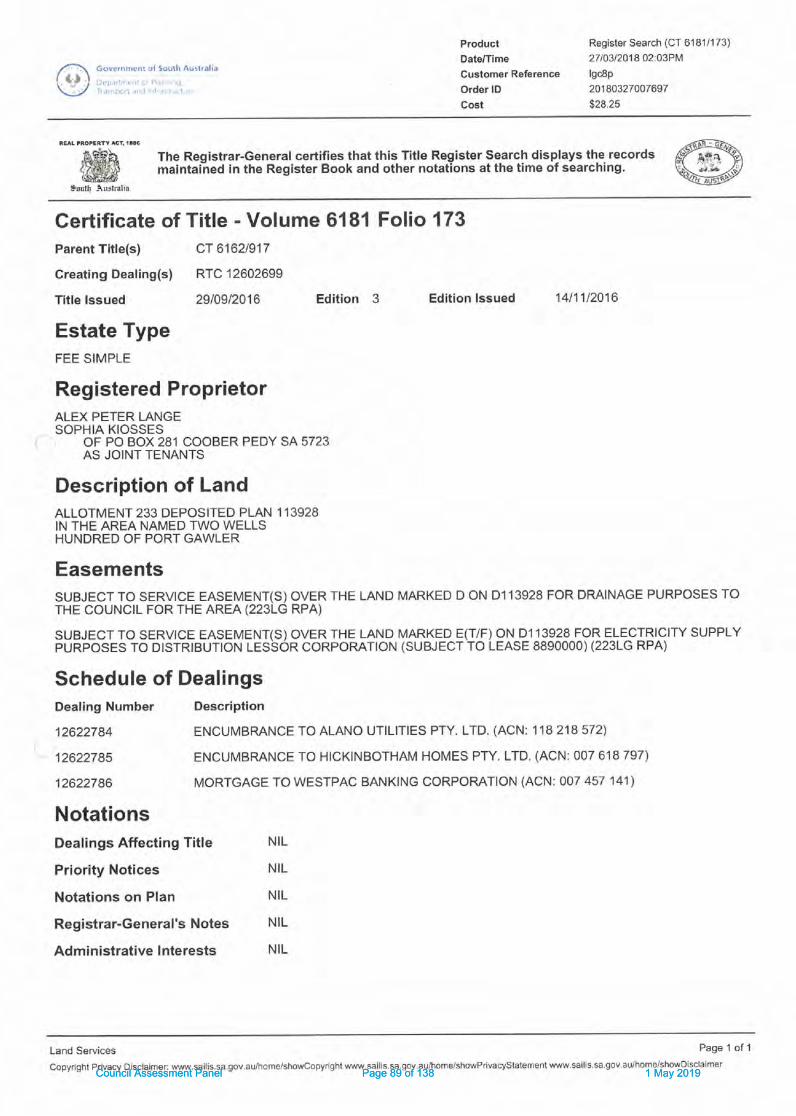
Gove.nnr(nl ol Soulh Autlfdli.l
::,.."
ProduclDals/Tlme
Cuglomsr Reference
Order lD
Cost
Register Search (CT 6181/173)
27103120'tg 02:O3PM
lscSp
20180327007697
$28.25
*'6s'h '- The Registrar-General certifies that this Title Register Search disp.lays th€records #.ffi,,ffi maintai-ned in the Register Book and other notations at the time of searching. \g*kp
irut! -\nslralia
Certificate ofParent Title(s)
Creating Dealing(s)
Title lssued
Estate TypeFEE SIMPLE
12622784
12622785
12622786
NotationsDealings Affecting Title
Priority Notices
Notations on Plan
Registrar-General's Notes
Administrative Interests
Titfe - Volume 6181 Folio 173cT 6162t917
RTC 12602699
2910912016 Edition 3 Edition lssued 14t1',U2016
Registered ProprietorALEX PETER LANGESOPHIA KIOSSES
OF PO BOX 281 COOBER PEDY SA 5723AS JOINT TENANTS
Description of LandALLOTMENT 233 DEPOSITED PLAN 1 13928IN THE AREA NAMED TWO WELLSHUNDRED OF PORT GAWLER
EasementsSUBJECT TO SERVICE EASEMENT(S) OVER THE LAND MARKED D ON D1 '13928 FOR DMINAGE PURPOSES TOTHE COUNCIL FOR THE AREA (2231G RPA)
SUBJECT TO SERVTCE EASEMENT(S) OVER THE LAND MARKED E(T/F) ON,D_1 13928 FOR ELECTRICITY SUPPLYpuRposEs To DtsrRtBUTtoN LESSoR coRpoRATroN (suBJEcr ro LEASE 8890000) (2231G RPA)
Schedule of DealingsDealing Number Description
ENCUMBRANCE TO ALANO UTILITIES PTY. LTD. (ACN: 1 18 218 572)
ENCUMBMNCE TO HICKINBOTHAM HOMES PTY. LTD. (ACN: 007 618 797)
MORTGAGE TO WESTPAC BANKING CORPORATION (ACN: 0O7 457 141)
NIL
NIL
NIL
NIL
NIL
Land Services Page 1 of 'l
copyrightPrivacyDisc|aimerlwww'sailis.sa'gov'au/home/showcopyrightwww.sai|is.sa'goV.aU/home/showPrivacyStatementw.sCouncil Assessment Panel Page 89 of 138 1 May 2019Council Assessment Panel Page 89 of 138 1 May 2019

3'o December 2018
Brendon SchulzAdelaide Plains CouncilPO Box 18Mallala, SA 5502
RegionaI Ptanning
Directions' ..I ,.',rii
P0 Box 67. Spr nqtof SA 5235p 08 8508 2037 m 0488 451 970
lrcnr t0rcq oral;l arnir!tdirflll0fs c0'n aLl
',rwv\'.reU 0r1dl! airnlfgdirer:lions con a r
ABN 80 r 52 935 352
Dear Brendon.
PROPOSAL TO ERECT A SHED FOR DOMESTIC PURPOSES AT LOT 233 MAGNOLIA
BOULEVARD, TWO WELLS (DA 312/065/2017)
I write in support of the proposal by Alex Lange (my Client) to erect a shed for domesticpurposes in conjunction with rural living at Lot 233 Magnolia Boulevard, Two Wells (the
subject land). This statement addresses the planning rules as existed at the time oflodgemenl of the application and provides assurances to Council in relation to flood
management and lhe liability question. Further amendmenls have also been made to the
dimensions of the shed and details are forwarded herewith.
Background
My Client submitted the applicaiion in March 2017.ln correspondence daled the 20'n ofApril 2017 Council requesled clarification of the location of the shed in order to determine
whether lhe shed was in Flood Hazard Zone 3.
In March 2018 a flood report was submitted to Council prepared by Mr Geoff Fisher of
Australian Waler Environments on behalf of my Client. Mr Fisher advised on the
appropriate location of the shed and a suitable configuration for the shed lo manage the
impact of floods using a combination of dry and wet flood protection, and suggesled that a
Lanad Management Agreement be used to indemnify Council.
Since then Council indicated that the proposal would not be supported unless the floorlevels are raised on an island at leasl 150 mm above the 1OOyear flood level and that it did
not consider an LMA as a suitable mechanism for indemnification. Council reached thisview in consideralion oI a perceived liability n'sk and a draft report prepared by a planning
consullant (Trevor White). Mr White's report makes a case for dry flood proteclion on thebasis of the provisions under Hazards in the Council Wide section plus a selection ofprovisions within the Rural Living Zone.
Parallel to lhe application for a shed, Council has been negotiating with the Hickinbotham
Group for the provision of broad fill for several allotments on the eastern side of Magnolia
Boulevard. A Development Application (DA No. 312124912018) for broad filling, including aportion of my Client's property, is currently being processed by the Council and is a
noncomplying form of development. Whilst my Client's support this proposal they would
like their shed proposal to be processed in the current and preferred location.
Council Assessment Panel Page 90 of 138 1 May 2019Council Assessment Panel Page 90 of 138 1 May 2019

Nature of Proposal
The proposed shed is for domestic storage and does not constitute a change of land use
but is a form of building work and associated fill.
The proposal was submitted in March 2017 and the Development Plan Provisions dated
the 21d of April 2016 are those relevani to an assessment of the applicaiion. The subject
land is in the Rural Living Zone (Precinct 3). lt is a consent form of development within
Flood Hazard Zone 2 of the Gawler River 1OOyear flood plain.
The application is io be treated as a Category 1 Development not requiring public
consultation in accordance with Clause 2 (d) of Part 'l of Schedule I of the Development
Regulations.
The subiect land and Localitv
The subjec{ land is 6 (loi 233) Magnolia Boulevard, Two Wells, is 1.213 hectares in area,
and is conlained in CT 61811173. The subjecl land extends from Magnolia Boulevard on
the westem side to Secomb Road in lhe east.
A slormwater easement is situated across lhe back of the property extending along the
back of several adjoining allotments to the north and the south. An easement on the
adjoining property located adjacent to the northern boundary of the subjec,l land provides
for storm water drainage from Magnolia Boulevard io the rear of ihe allotments. An
easement over a small rectangular area is located at the northeastem corner of the
subject land. Alano Utilities, and Hickinbotham Homes each have an encumbrance
registered on the iitle.
A raised platform towards the tront of the property has a new single story detached
dwelling erected on it. The remainder of the subject land slopes gently to a low area
towards the rear of the property. Some fill has been placed on lhe subject land in
anticipation of preparing a pad for the proposed shed.
Land on the eastem side of Magnolia Boulevard has been subdivided into rural living
properties. Residential development associated with the Eden Estate is situaled on the
westem side of Magnolia Boulevard. Primary produclion lands are situaled furlher east.
Land use south of Gawler/Two Wells Road is predominantly farming and rural living.
The topography is relatively low lying and falls gently from Magnolia Boulevard lo a
stormwaier basin on the eastern edge of the locality. Salt creek is situated to lhe east and
crosses the Gawler/Two Wells Road close to the intersection with Secomb Road. Land
abutting ihe eastem side of Magnolia Boulevard is within the 'lO0year flood plains of both
the Light and the Gavyler Rivers and the rural living allotments on this side of the road all
have house pads raised above lhe 1OOyear flood level.
DEtails of Proposal
The proposal is lo erect an 18.3 metre by 12.015m colourbond shed covering 219.9
square metres in area. The wall height is to be 4.267m and the height to the apex of lheroof would be 5.654m. The shed is to be situaied on lop of a raised pad 510mm above
natural ground level and no less than 11.67mAHD (see flood advice from Geoff Fisher).
The dimensions of lhe shed have been slightly amended by reducing the height from
6.264m down lo 5.654m and increasing the length from 15.2m to 18.3m (see amended
Council Assessment Panel Page 91 of 138 1 May 2019Council Assessment Panel Page 91 of 138 1 May 2019
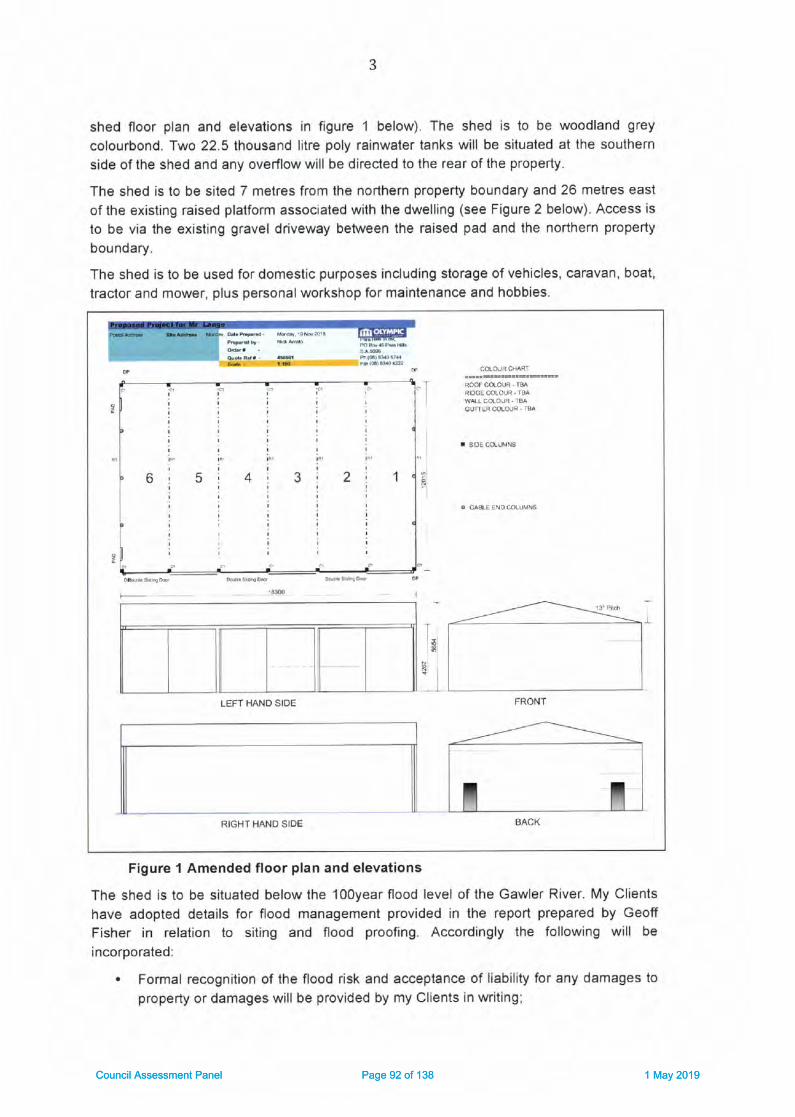
shed floor plan and elevalions in figure 1 below). The shed is to be woodland grey
colourbond. Two 22.5 thousand lilre poly rainwater tanks will be siluated at the southern
side of the shed and any overflow will be direcled to the rear of the property.
The shed is to be sited 7 metres from the northern property boundary and 26 metres east
of the existing raised platform associaled with the dwelling (see Figure 2 below). Access is
to be via the existing gravel driveway between the raised pad and lhe northern property
boundary.
The shed is to be used for domestic purposes including storage of vehicles, caravan, boat,
lractor and mower, plus personal workshop for maintenance and hobbies.
Figure 1 Amended floor plan and elevations
The shed is to be situated below lhe 100year flood level of the Gawler River. My Clients
have adopted details for flood management provided in the report prepared by Geoff
Fisher in relalion to siting and flood proofing. Accordingly the following will be
incorporated:
. Formal recognilion of the flood risk and acceptance of liability for any damages to
property or damages will be provided by my Clients in writing;
ROOF COLOUR IsARIOOE MLOUR. TI]A
cUfiER COLC|!R . rBA
r sDE 6I,INS
. dASIE END COLIJMNS
I
:
I
I
t)1a'. 1
I
I
-mm
FRONTLEFT HAND SIDE
RIGHT HAND SIDE
Council Assessment Panel Page 92 of 138 1 May 2019Council Assessment Panel Page 92 of 138 1 May 2019

4
. The shed will not be habitable, norwill it be used for that purpose;
. The shed will be designed by a suitably qualified designer to ensure that it can
withstand partial inundation;. Foundations will be able to maintain the necessary support for the structure during
a flood situation;. The finished floor level of the shed is to be set no less ihat 640 mm above existing
ground level, at 11.94m AHD.
' The sections and areas of the shed poientially inundated will be constructed from
flood damage-resistant materials to reduce flood damage and facililale cleanup.. The shed will be configured to minimise damage from inundation including intemal
drainage lo facilitale washing after a flood;
' Shelving, and any power outlets and any unsealed containers, or stored maierial
subject to damage by floodwaters within the shed will be set 150 mm above the 1
in 100 year ARI flood level (ie no lower than 12.72 mAHD;. Certification from the shed designer will be provided at the building rules stage that
these conditions will be satisfied;. Equipment stored in the shed where not on a shelf above the 100 year flood level
will be relocated to high ground out of the flood prior to inundation.
An Emergency Management Plan (EMP) will be prepared to Council and the SES's
satisfaction embodying early waming mechanisms and triggers for evacuation.
P I an n I ng C o nsl d eratlo ns
Crlme Prevetrtlon
Cunently vehicles and equipment are slored in the open within the flood prone section ofthe property. The parking of my Client's caravan, boat, utility, trailers etc. within a shed
able 1o be locked securely on the subject land plus motion activaled lighting at lhe rear ofthe shed will ensure a higher level of security and surveillance of these valuable iiems in
line with Objective 1 under Crime Prevention.
Deslgn and Appeannce
The proposed building design, overall size and colours, screen planting, and site layout
woufd be in accordance with Objectives '1, 2, plus principles 1, 2, 3 (b), 5,7,13, and 20.
The building is not considered overly large for a rural living area and as such articulation,
variation to facades etc. are not considered necessary. The shed is consistent with the
rural living character, and thereby reinforces Objeclive 1. The shed will largely be
screened from view of Magnolia Boulevard being sited at a lower level and would be
screened through planting of olive trees from the north, soulh, and east.
Energy Efflclency
The orientation of the shed with the long sides facing north and south and siting well with
the boundaries of the subject land will maximize exposure to sunlight for futurephotovoltaic cells placed on the roof for onsite power generation. As such the proposal
would be in accordance with Objective 2 and Principle 3 (a) (b).
Council Assessment Panel Page 93 of 138 1 May 2019Council Assessment Panel Page 93 of 138 1 May 2019

>F;
Figure 2: Amended Site Plan
Council Assessment Panel Page 94 of 138 1 May 2019Council Assessment Panel Page 94 of 138 1 May 2019

Hazards
Although the subjeci land is in the 1OOyear flood plain the shed is to be located in Hazard
Zone 2 and is supported by flood advice from a qualified hydrological engineer. The extent
of filling would not exceed lOmetres beyond the exlemal wall of the shed. Furthermore the
subject land is in a masler planned esiaie development with an engineered design
capable of draining a 'tOOyearflood evenl.
Notwithstanding that the floor level would be below the 1oOyear ARI flood level the shed
will be evacuated prior to a flood and any equipment or vehicles will be removed in
advance of flooding. Such approach is considered acceptable in other Council's where
flooding occurs including wilhin the 1956 flood plain of the Munay River where much
higher inundation levels may occur.
Whilst access to the shed during a flood would not be safe, evacuation procedures will be
included in an Emergenry Management Plan to be provided by the applicant subject to
any special conditions applied by Council. Such EMP would need lo cover all
conlingencies such as visitors and ienants.
My Client is happy to confirm acceptance of any liability and sign a waiver if requested by
Council. This could be reinforced by a disclaimer in the form of a note on the consent.
Should the Council take the view that such waiver or indemnific€tion from the applicant
would not be sufficient lo cover fulure owners then the approval could be limited to the
cunenl applicant. In so doing future owners would be required lo submit a development
application and would be required to renew the indemnification.
It hss been suggested by Geoff Fisher that indemnification may be provided through a
Land Managemenl Agreemenl. However this is not common practice for outbuildings in
flood plains and in my opinion such measure should not be necessary as the above
procedures would be sufficient. As the proposal is supported by a flood engineer from a
reputable engineering consulting firm there should be no risk to Council.
The proposal provides a combinalion of wet and dry flood proofing. With up to 640mm
above ground level the raised pad provides a reasonable amounl of dry flood proofing. A
contingency for higher floods would be created through design measures and procedures
for evacuation will ensure that the risk to life and property is adequately addressed
ensuring thai the intent of Principle 5 (b) would be met. Similarly the intent of Principle 6
(b) (d) and (f) (i) would also be met.
It is also pointed out that any variance in relation to the above such as a lesser than
150mm of freeboard, the entry of floodwalers, and a 2O0mm driveway are issues that
have been envisaged at the zone level lhrough the following reference in the Desired
Character Slatemenl for the Rural Living Zone as follows:
Dwetlings and ancillary buildings and structures will be located and designed to
prevent entry by floodwaters. This wilt pimaily be achieved through the nising offloor levels above the flood level, although afternative solutions may be appropriate
in limited circumstances provided specific flood proofing measures arc included
within any design and construc'tion (my underlining)
The proposal would meet this requirement through the combinalion of wet and dry flood
proofing. Furthermore as the zone provisions are more specific to lhe context of the zone
Council Assessment Panel Page 95 of 138 1 May 2019Council Assessment Panel Page 95 of 138 1 May 2019

and altemative measures have been supported by a qualified hydrological engineer I am
of the view that the proposal accords with the relevant provisions in relalion to flooding.
The proposal is also in a general bushfire risk zone being the lowest of three bushfire
hazard risk categories and would be afforded significanl protection from bushfire hazard.
The additional rainwater tanks could also be used for fire fighting purposes. The shed itself
would not incorporate flammable building materials to the exterior and is of a design lhat
does not cause entrapment of debris.
In view of the above the proposal would be consistent with Objectives 1, 2, 3, 4, 5, 6' and
Principles 1, 2, 4, 5 (a), 6 (e) (0 (iD, 7 (a) (b) (c) (d) (e), 8, e, 12, and 13.
La ndsc apl ng, FEnces a nd Wal ls
The proposed screen planting on the southem, northem, and eastem sides of the shed
will ensure that the proposal is in accord with objeclives 1 and 2 under the section on
Landscaping, Fences and Walls. The proposal would also be in accordance wiih principle
1 (a) (d) (e) 0),2 (a), 3 (a) (b), and 4 (b) (c) (h).
Nafrtnl Resources
The shed is to be sited well back fiom ihe lower lying section of the property thereby
ensuring adequate separation distance from the main siormwater drainage system for the
Eden estate.
Catchment of roof runoff within two large rainwater lanks for reuse on the sile will ensure
more suslainable prac{ices. The site is large enough so thai the overflow can be directed
to grassy areas away from the building.
The proposal is consistent with the character of rural living and residential development in
the area and would not impast on the natural or rural landscape. Proposed screen planling
of olive groves would add to the rural character of the culTenlly open landscape
The proposal minimises modifications to the existing landform by limiting the level of fill to
64gmm and would preserve the landscape and environment as much as possible. At the
same time the proposal would elevate the shed sufficiently and provide shelves for
storage and electrical connections above lhe 1OOyear flood level to be safe from flooding.
In view of the above the proposal would be significantly in accord with Objectives 1, 2, 3,
4,6 (a) (b) (c) (d) (e) (f),7, 10, and 13, plus Principles 1,6,7,8 (a) (b),9 (b), 10, 11, 12,
13, 15 (a) (b) (D (iD.
Orderly and Sustalnable Development
The proposal would be in accord with the relevant provisions for orderly and sustainable
development as il maintains consistency with the zone provisions and str€ngthens the
alignment with the desired character stalement for the zone in that it facilitates the better
enjoyment of the property in accordance with the Rural Living Zone provisions and adopts
profiossional fl ood advice.
Resldentl a I D evelo P me nt
The proposal would contribute towards the creation of a safe, convenient and healthy
living environment in that it satisfies both hydrological engineering standards for flooding
and the bushfire requirements. The proposal would facilitate the belter enjoyment of a
Council Assessment Panel Page 96 of 138 1 May 2019Council Assessment Panel Page 96 of 138 1 May 2019

rural/residential living property and as such meets Objective 1 for Residential
Developmenl.
The proposal would also be in accord with Principles 9, 16, 17, 18, and 40. The sub.iect
land is large enough to accommodate the shed and provide all of the items listed in
Principle 23 (a) (b) (c) (d) (e) (0.
Siting and Vislblltty
The proposal is consistent wilh the semi rural character of the locality. Due to the location
and siting ofthe proposed shed sunounded on four sides by screen planting, and situated
at a slighily lower lever than lhe existing dwelling, lhe visibility from adjoining properties
and Magnolia Boulevard would be significantly reduced over time. Hence the proposal will
bd in accord with the relevant provisions under Sl'flng and Wsibility.
T ra nspo rtatl on and A ccess
Due to the provision of a driveway to the shed the proposal would be in accord with the
relevani provisions for Transporlation and Access.
Runl Llvlng Zone
The proposal would contribute to the enjoyment of ihe land for rural / residential purposes
and thereby supports Objective 'l for the RL Zone. The flood management details provided
through hydrological engineering advice provides an approach that minimizes the risks to
safety and property from flooding of the Gawler River, Salt Creek, and the Light River in
accordance with Objective 2 for the Zone.
Objective 3 and Principle 6 reinforce the desired characler for the Zone, which in tum
stipulates the provision of appropriate buffers, and proleclion of the amenity and outlook
from adjoining resideniial areas. lt also stipulates ecofriendly building design, water
sensitive design, flood mitigation measures, reinforcement of the semirural character of
the zone, and the provision of landscaping. All of these will be met through the following
measures:
. A well designed colourbond shed at a lower level than the existing dwelling well
setback from the streel:. The provision of screen planting;
" Incorporating flood mitigation measures recommended by a qualified hydrological
engineer;. The inclusion of two 22,500 litre rainwater tanks for reuse of water on sile;
. North south roof orientation to facilitate solar power generation.
The proposal is for domestic use and as such would be consistent with the restrictions on
a hom+.based business in Precinct 3 as stipulated in the desired character Provisions.
The provisions also stipulate that development should not increase the potential for
blockage of floodways or flow paths and cause offsite impacts. The flood advice provided
not only demonstrates that the proposal would not impact on flood flows but also provides
an altemative solution appropriate to the particular conlext as is qountenanced by ihe
desired charaster statement.
The proposal satisfies Principle 1 for the zone in that ii is a domestic outbuilding
associated with an existing dwelling on the subjeci land.
Council Assessment Panel Page 97 of 138 1 May 2019Council Assessment Panel Page 97 of 138 1 May 2019

The proposal is consistent with most of the parameters stipulated in Principle 8 by not
exceeding 3OOsquare metres floor area, nol exceeding 6.5 metres in height, only slightly
exceeding 4.2mwall height, not being localed less lhan 20 metres from the primary road
frontage, and being more than 12 melres from the rear boundary.
The proposal falls short of the requirement for the side boundary setback in ihat the
proposed 7m setback would require 5 metres plus I metre for every additional 500mm of
height of the wall above 2.7m measured from natural ground level. The height would be
1.5m above the 2.7m plus 640mm lo natural ground level meaning that an extra 4 melres
should be accommodated requiring up to 9 metres setback. \A/hilsl the proposal would fall
2 metres short with a setback of 7m the combination of setback and planting of olive trees,
plus colourbond finish would mitigate any visual impact.
The proposal, in conjunction with the existing dwelling, would not exceed the threshold
limit for site coverage expressed in Principle 12 for the Zone.
My Clients have accepted the recommendaiions of Mr Geofi Fisher a qualified
hydrological engineer and as such the proposal is likely to salisfy the safety requirements
of Principle 24 of the Precinct 3 Provisions for Two Wells. li is also noted that the
subdivision proceeded with foreknowledge of the extent of flooding and as such Council
should make allowance for limited development on the flood plain.
Liabilitv and Development Deqisions
Council's cunent position suggests liability risk should be the dominant factor determining
the oulcome of an assessment against the relevant provisions of lhe Development Plan
regardless of any engineering advice or Development Plan provisions to the contrary. lflhis were the case then Council should not have allowed the subdivision of the land in the
first place as no condilions or conlrols have been placed on storage of items such as cars,
trailers, or equipmenl within the flood affected portions of the subjec't land.
Clearly such approach would be untenable firstly, because the Development Act requires
Council to have regard lo lhe Developmenl Plan in determining its developmeni decisions
and liability is not even factored as a requirement of the planning rules. Secondly' the
Rural Living Zone makes a clear exception for land division in Poliry Area 3 and Council
had no allernalive but to approve the land division. The upshot of this is that if the
Development Plan allows for it Council is only doing the right thing in approving a
development regardless of the liability question.
It is only common sense that if Council follows the planning rules and relevant engineering
advices then il would be unlikely to have any reason to be held liable in the eveni that
there was a flood and any items and vehicles left on the flood prone porlions of the subject
land were not removed by the land owner or occupanl prior to a flood resulting in damage
as it would clearly be the fault of lhe owner or occupier.
Equally liability should not be considered as a key contextual issue in the decision process
for the proposal al hand, as the relevant fiactors for consideration should only be the
relevant planning rules and the relevani advice of a hydrological engineer. The offer of
entering into a Land Management Agreement to indemnify Council was only suggesled loprovide added assurances lo Council and in my opinion is not necessary to maintain
compliance with the planning requiremenls.
Council Assessment Panel Page 98 of 138 1 May 2019Council Assessment Panel Page 98 of 138 1 May 2019

10
lf Council is of a mind not to include an LMA then my suggesled alternative would be to
include a disclaimer as a note lo the consent similar to that used by the Coast Prolection
Board. This could be supported by a condition requiring the applicant to prepare an
Emergency Managemenl Plan (EMP) to the Council and SES satisfaction. A furlher
condition could be added requiring that any lenants or fulure owners also need to comply
with the EMP.
Conclusion
The proposal is for the construction of a shed for domestic use in conjunction wilh an
existing dwelling on the subject land. The application was submilted prior to amendments
introduced in February of this year and as such the earlier Development Plan provisions
and 1993 flood mapping is relevant to the proposal at hand.
The proposal performs relatively well against the relevant planning provisions in the
Council Wide section, for the Rural Living Zone, and Precinct 3 for Two Wells. Although
the finished floor level of the proposed shed would not be sel 150mm above the 100yr
flood plain, alternative flood management measures have been provided and have the
supporl of a respected hydrological engineer. Such alternative measures are
countenanced within the Desired Character Statement for the Rural Living Zone and
should carry more weighl in the assessment than the Council Wide provisions.
In view of the above I recommend the proposal for favorable consideration subjeci to such
conditions Council sees fit in terms of reinforcing the flood management details outlined by
Geoff Fisher, a requirement for a EMP to be prepared by the applicant to the satisfaction
of Council, plus a disclaimer of future liability by Council in the form of a note
Council may prefer to require that the EMP make provision for the contingency of tenants
and visitors and limit the approval to the current owner so that future owners are required
to accept their own liability obligations when reapplying.
I also recommend the proposal for consideration as a Category 1 application not requiring
public consultation. Should you require additional informaiion or have any questions inrelalion 1o the proposal please do not hesitale to contact me on 08 85682037 or
048845 1 970 or via ema il o n hen ri@regi on alplqn n!!Sqll99!o!!
Yours sincerely
-,-/ -;2=_-Henri MuellerDIRECTOR - REGIONAL PLANNING DIRECTION
Council Assessment Panel Page 99 of 138 1 May 2019Council Assessment Panel Page 99 of 138 1 May 2019

LL
ATTACHMENT 1: RELEVANT PROVISIONS(Source: Development Plan Provisions for Mallala
Gouncil consolidated 21"t April 2016)
Crime Prevention
OBJECTIVES
1 A safe, secure, crime resistant environment where land uses areintegrated and designed to facilitate community surveillance.
PRINCIPLES OF DEVELOPMENT CONTROL
7 Site planning, buildings, fences, landscaping and other features shouldclearly differentiate public, communal and private areas.
Design and Appearance
OBJECTIVES
1 Development of a high architectural standard that responds to andreinforces positive aspects of the local environment and built form.
2 Roads, open spaces, buildings and land uses laid out and linked so thatthey are easy to understand and navigate.
PRINCIPLES OF DEVELOPMENT CONTROL
1 The design of a building may be of a contemporary nature and exhibit aninnovative style provided the overall form is sympathetic to the scaleof development in the locality and with the context of its setting withregard to shape, size, materials and colour.
2 Buildings should be designed and sited to avoid creating extensive areasof unintemrpted walling facing areas exposed to public view.
3 Buildings should be designed to reduce their visual bulk and provide
visual interest through design elements such as:
(a) articulation
(b) colour and detailing
(c) small vertical and horizontal components
Council Assessment Panel Page 100 of 138 1 May 2019Council Assessment Panel Page 100 of 138 1 May 2019
L2
(d) design and placing of windows
(e) variations to facades.
5 Building form should not unreasonably restrict existing views availablefrom neighbouring properties and public spaces.
7 The external walls and roofs of buildings should not incorporate highlyreflective materials which will result in glare to neighbouring propertiesor drivers.
13 Buildings, landscaping, paving and signage should have a co-ordinatedappearance that maintains and enhances the visual attractiveness ofthe locality.
17 Outdoor lighting should not result in light spillage on adjacent land.
20 Sheds and garages, other than stables, kennels and animal pens,should not be of a size that will visually dominate surroundingdwellings.
Energy Efficiency
OBJECTIVES
2 Development that provides for on-site power generation includingphotovoltaic cells and wind power.
PRINCIPLES OF DEVELOPMENT CONTROL
On-site Energy Generation
3 Development should facilitate the efficient use of photovoltaic cells andsolar hot water systems by:
(a) taking into account overshadowing from neighbouring buildings
(b) designing roof orientation and pitches to maximise exposure todirect sunlight.
Hazards
OBJECTIVES
1 Maintenance of the natural environment and systems by limitingdevelopment in areas susceptible to natural hazard risk.
Council Assessment Panel Page 101 of 138 1 May 2019Council Assessment Panel Page 101 of 138 1 May 2019

13
2 Development located away from areas that are vulnerable to, and cannotbe adequately and effectively protected from the risk of naturalhazards.
3 Development located to minimise the threat and impact of bushfires onlife and property.
4 Expansion of existing non-rural uses directed away from areas of highbushfire risk.
5 Development located and designed to minimise the risks to safety andproperty from flooding.
6 Development in the Gawler River Flood Plain which is designed and sitedto minimize the varying potential flood impacts that occur within 'Flood
Hazard Zone 1 ', 'Flood Hazard Tone 2' or Flood Hazard Zone 3', asshown on the Gawler River Flood Hazard Map - GRO Map No.238/1993.
PRINCIPLES OF DEVELOPMENT CONTROL
1 Development should be excluded from areas that are vulnerable to, andcannot be adequately and effectively protected from, the risk ofhazards.
2 Development located on land subject to hazards as shown on the OverlayMaps - Development Constrainfs should not occur unless it is sited,designed and undertaken with appropriate precautions being takenagainst the relevant hazards.
Flooding
4 Development should not occur on land where the risk of flooding is likelyto be harmful to safety or damage property.
5 Development should not be undertaken in areas liable to inundation bytidal, drainage or flood waters unless the development can achieve allof the following:
(a) it is developed with a public stormwater system capable ofcatering for a 1-in-100 year average return interval flood event
(b) buildings are designed and constructed to prevent the entry offloodwaters in a 1-in-100 year average return intervalflood event.
6 Within the 'Gawler River Flood Plain' as shown on the Ovelay Maps -Deve lo pm ent C o n strai nts:
Council Assessment Panel Page 102 of 138 1 May 2019Council Assessment Panel Page 102 of 138 1 May 2019

14
(b) the finished floor levelfor outbuildings should be a minimum of1 50 millimetres above the height of a '1-in-100 year average returninterval flood event of the Gawler River or natural surface level,whichever is greater
(d) filling for purposes ancillary to or associated with an approved useof land should be to a maximum of 100 millimetres above naturalground level
(e) filling required to raise the finished floor level of a building shouldnot extend more than 10 metres bevond the external walls of thatbuilding
(f) driveways should be:
(i) filled to a maximum of 100 millimetres above naluralgroundlevel
(ii) no more than 5 metres wide.
7 Development, including earthworks associated with development, shouldnot do any of the following:
(a) impede the flow of floodwaters through the land or othersurrounding land
(b) increase the potential hazard risk to public safety of personsduring a flood event
(c) aggravate the potential for erosion or siltation or lead to thedestruction of vegetation during a flood
(d) cause any adverse effect on the floodway function
(e) increase the risk of flooding of other land
Bushfire
8 The following bushfire protection principles of development control applyto development of land identified as General, Medium and Highbushfire risk areas as shown on the Bushfire Protection Area BPAMaps - Bushfire Risk.
9 Development in a Bushfire Protection Area should be in accordance withthose provisions of the Ministels Code: Undertaking development inBushfire Protection Areas that are designated as mandatory forDevelopment Plan Consent purposes.
Council Assessment Panel Page 103 of 138 1 May 2019Council Assessment Panel Page 103 of 138 1 May 2019

15
12 Extensions to existing buildings, outbuildings and other ancillarystructures should be sited and constructed using materials tominimise the threat of fire spread to residential, touristaccommodation and other habitable buildings in the event of bushfire.
13 Buildings and structures should be designed and configured to reducethe impact of bushfire through using simple designs that reduce thepotential for trapping buming debris against the building or structure,or between the ground and building floor level in the case oftransportable buildings.
Landscaping, Fences and Walls
OBJECTIVES
1 The amenity of land and development enhanced with appropriate plantingand other landscaping works, using locally indigenous plant specieswhere possible.
PRINCIPLES OF DEVELOPMENT GONTROL
1 Development should incorporate open space and landscaping andminimise hard paved surfaces in order to:
(a) complement built form and reduce the visual impact of largerbuildings (eg taller and broader plantings against taller andbulkier buildin g components)
(d) minimise maintenance and watering requirements
(e) enhance and define outdoor spaces, including car parkingareas
fi) maximise stormwater reuse
2 Landscaping should:
(a) include the planting of locally indigenous species whereappropriate
3 Landscaping should not:
(a) unreasonably restrict solar access to adjoining developmenl
(b) cause damage to buildings, paths and other landscaping from
Council Assessment Panel Page 104 of 138 1 May 2019Council Assessment Panel Page 104 of 138 1 May 2019

76
root invasion, soildisturbance or plant overcrowding
4 Fences and walls, including retaining walls, should:
(b) be compatible with the associated development and with existingpredominant, attractive fences and walls in the locality
(c) enable some visibility of buildings from and to the street to enhancesafety and allow casual surveillance
(h) be constructed of non-flammable materials.
Natural Resources
OBJECTIVES
1 Retention, protection and restoration of the naturalresources andenvironment.
2 Protection of the quality and quantity of South Australia's surface waters,including inland, maine and estuaine and underground waters.
3 The ecologically sustainable use of natural resoures including, but notlimited to, marine waters, groundwater, surface water andwatercourses.
4 Natural hydrological systems and environmentalflows reinstated,maintained and enhanced while providing allowances for floodmitigation measures.
6 Development sited and designed to:
(a) protect natural ecological systems
(b) achieve the sustainable use of water
(c) protect water quality, including receiving waters
(d) reduce runoff and peak flows and prevent the risk ofdownstream flooding
(e) minimise demand on reticulated water supplies
(f) maximise the harvest and use of stormwater
7 Storage and use of stormwater which avoids adverse impact on publichealth and safety.
Council Assessment Panel Page 105 of 138 1 May 2019Council Assessment Panel Page 105 of 138 1 May 2019
L7
10 Minimal disturbance and modification of the natural landform.
13 Protection of the scenic qualities of natural and rural landscapes.
PRINCIPLES OF DEVELOPMENT CONTROL
1 Development should be undertaken with minimum impact on the naturalenvironment, including air and water quality, land, soil, biodiversity,and scenically attractive areas.
Water Sensitive Design
6 Development should be designed to maximise conservation, minimiseconsumption and encourage reuse of water resources.
7 Development should not take place if it results in unsustainable use ofsurface or underground water resources.
8 Development should be sited and designed to:
(a) capture and reuse stormwater, where practical on site
(b) minimise surface water runoff
9 Water discharged from a development site should:
(b) not exceed the rate of discharge from the site as it existed in pre-development cond itions.
10 Development should include stormwater management systems toprotec't it from damage during a minimum of a 1-in-100 year averageretum interval flood event.
11 Development should have adequate provision to control any stormwaterover-flow runoff from the site and should be sited and designed toimprove the quality of stomwater and minimise pollutant transfertoreceiving waters.
12 Development should include stormwater management systems tomitigate peak flows and manage the rate and duration of stormwaterdischarges from the site to ensure the carrying capacities ofdownstream systems are not overloaded.
13 Development should include stormwater management systems tominimise the discharge of sediment, suspended solids, organic matter.nutrients, bacteria, litter and other contaminants to the stormwatersystem.
Council Assessment Panel Page 106 of 138 1 May 2019Council Assessment Panel Page 106 of 138 1 May 2019

18
15 Stormwater management systems should:
(a) maximise the potentialfor stormwater harvesting and reuse,either on-site or as close as practicable to the source
(b) utilise, but not be limited to, one or more of the followingharvesting methods:
(i) the collection of roof water in tanks
(ii) the discharge to open space, landscaping or garden areas,including strips adjacent to car parks
Orderly and Sustainable Development
OBJECTIVES
1 Orderly and economical development that creates a safe, convenient andpleasant environment in which to live.
3 Development that does not jeopardise the continuance of adjoiningauthorised land uses.
4 Development that does not prejudice the achievement of the provisions ofthe Development Plan.
PRINCIPLES OF DEVELOPMENT CONTROL
1 Development should not prejudice the development of a zone for itsintended purpose.
2 Land outside of townships and settlements should primarily be used forprimary production and conservation purposes.
8 Vacant or underutilised land should be developed in an efficient and co-ordinated manner to not prejudice the orderly development ofadjacent land.
Residential Development
OBJECTIVES
1 Safe, convenient, pleasant and healthy-living environments that meet thefull range of needs and preferences of the community.
PRINCIPLES OF DEVELOPMENT CONTROL
Council Assessment Panel Page 107 of 138 1 May 2019Council Assessment Panel Page 107 of 138 1 May 2019

L9
9 Residential development should be designed in association with rainwater tanks having a storage capacity of at least 10 000 litres in urbanareas and 2200O litres in rural and rural living areas, independent offire fighting purposes.
Garages, Carports and Outbuildings
16 Garages, carports and outbuildings should have a roof form and pitch,building materials and detailing that complement the associateddwelling.
17 Garages and carports facing the street should not dominate thestreetscape.
18 Residentialoutbuildings, including garages and sheds, should not beconstructed unless in association with an existing dwelling.
Site Goverage
23 Site coverage should be limited to ensure sufficient space is provided for:
(a) pedestrian and vehicle access and vehicle parking
(b) domestic storage
(c) outdoor clothes drying
(d) a rainwater tank
(e) private open space and landscaping
(f) front, side and rear boundary setbacks that contribute to the desiredcharacter of the area
(g) convenient storage of household waste and recycling receptacles.
Car Parking and Access
40 Driveway crossovers should be single width and appropriately separated,and the number should be minimised to optimise the provision of on-street visitor parking.
Siting and VisibilityOBJEGTIVES
1 Protection of scenically attractive areas, particularly natural, rural andcoastal landscapes
Council Assessment Panel Page 108 of 138 1 May 2019Council Assessment Panel Page 108 of 138 1 May 2019
20
PRINCIPLES OF DEVELOPMENT CONTROL
1 Development should be sited and designed to minimise its visual impacton:
(a) the natural, rural or heritage character of the area
2 Buildings should be sited in unobtrusive locations and, in particular,should:
(a) be grouped together
(b) where possible be located in such a way as to be screened byexisting vegetation when viewed from public roads.
3 Buildings outside of urban areas and in undulating Iandscapes should besited in unobtrusive locations and in particular should be:
(c) sited in such a way as to not be visible against the skyline whenviewed from public roads
(d) set well back from public roads, particularly when the allotmentis on the high side of the road.
4 Buildings and structures should be designed to minimise their visualimpact in the landscape, in particular:
(a) the profile of buildings should be low and the roof lines shouldcomplement the natural form of the land
(b) the mass of buildings should be minimised by variations in walland roof lines and by floor plans which complement thecontours of the land
5 The nature of extemal surface materials of buildings should nol detractfrom the visual character and amenity of the landscape.
6 The number of buildings and structures on land outside of urban areasshould be limited to that necessary forthe efficient management ofthe land.
7 Development should be screened through the establishment oflandscaping using locally indigenous plant species:
(a) around buildings and earthworks to provide a visual screen as well asshade in summer, and protection from prevailing winds
Transportation and Access
Council Assessment Panel Page 109 of 138 1 May 2019Council Assessment Panel Page 109 of 138 1 May 2019

2t
OBJECTIVES
2 Development that:
(a) provides safe and efficient movement for all motorised and non-motorised transport modes
(b) ensures access for vehicles including emergency services,public infrastructure maintenance and commercial vehicles
PRINCIPLES OF DEVELOPMENT CONTROL
8 Development should provide safe and convenient access for allanticipated modes of transport including cycling, walking, public andcommunity transport, and motor vehicles.
10 Driveway cross-overs affecting pedestrian footpaths should maintain thelevel of the footpath.
Access
25 Development should have direct access from an allweather public road.
26 Development should be provided with safe and convenient accesswhich:
(a) avoids unreasonable interference with the flow of traffic onadjoining roads
32 Driveways, access tracks and parking areas should be designed andconstructed to:
(a) follow the natural contours of the land
(b) minimise excavation and/or fill
Rural Living Zone
OBJECTIVES
1 A zone consisting of large allotments, detached dwellings and ruralactivities that do not adversely impact the amenity of the locality.
2 Minimisation of risks to safety and property of flooding from the GawlerRiver, Salt Creek and the Light River.
3 Development that contributes to the desired character of the zone.
Council Assessment Panel Page 110 of 138 1 May 2019Council Assessment Panel Page 110 of 138 1 May 2019

22
DESIRED CHARACTER
It is envisaged that properties within the zone will be well landscaped withlocally indigenous plant species to promote privacy and to provide for thescreening of buildings and structures from neighbouring properties andpublic roadways.
The zone will be developed in a way that minimises potential amenityimpacts on sensitive land uses through the use of appropriate buffers andwill protect the amenity of and outlook from, the residential areas adjacent tothe zone and from Port Wakefield Road. All development will incorporateenvironmentally sustainable building design, eco-friendly and appropriatewater sensitive design techniques and, if required, flood mitigation measures.Vi/here possible, stormwater, detention and/ or retention basins will beincorporated into suitably designed and accessible areas of public openspace, provided such areas are useable for the majority of the year. lt isdesirable that the standard of development within these areas be such as toenhance the rural character and be compatible with the residentialfunctionand semi-rural environment. The semi-rural character of the zone will bereinforced and strengthened through the design and siting of buildings andstructures, open style fencing and appropriate landscaping to complimentthe landform.
There will be no industrial, commercial or retail uses. Home basedbusinesses and cottage industries are not desired in Precinct 3 Two Wells but
may be established elsewhere in the zone.
Portions of the zone are subject to inundation by floodwaters from theGawler River, Salt Creek and the Light River. Provision for recreation andopen space activities within areas subject to flooding is encouraged withinthe zone. lt is expected that new development will not increase the potentialfor blockage of floodways or alter flow paths, will not remove areas of floodstorage (through filling etc) and thereby impact on localized levels and flowpaths and will not increase pre-development volume and peak runoff levels.
Dwellings and ancillary buildings and structures will be located and designedto prevent entry by floodwaters. This will primarily be achieved through theraising of floor levels above the flood level, although alternative solutionsmay be appropriate in limited circumstances provided specific flood proofingmeasures are included within any design and construction.
PRINCIPLES OF DEVELOPMENT CONTROL Land Use
1 The following forms of development are envisaged in the zone:
. domestic outbuilding in association with a detached
Council Assessment Panel Page 111 of 138 1 May 2019Council Assessment Panel Page 111 of 138 1 May 2019

23
dwelling
Form and Character
6 Development should not be undertaken unless it is consistent with thedesired character for the zone.
I All buildings associated with a home based industry/ office, sheds (exceptfor stables, kennels and animal pens), garages and similaroutbuildings should be designed within the following parameters:
Maximum floor area 300 square metres
Maximum building height (from nalural ground level) 6.5 metres
Maximum wall height (from natural ground level) 4.2 metres
lvlinimum setback from primary road boundary wherethe floor area is 36 square metres or less and thevertical wall height measures no more than 2.7 metres
15 metres or the same distance as the existtngassocrated dwel rng, whichever is greater
Minimum selback from primary road boundary wherethe floor area is greater than 36 square melers
20 metres or the same distance as the existingassociated dwelling, whichever is greater
Minimum setback from side road boundary 8 metres plus 3 additional metre for everyadditional 500 millimetres above the 2.7 metreswall height measured from natural ground level
Minimum setback from side boundaries 5 metres plus 1 additional metre for everyadditional 500 millimetres above the 2.7 metreswall height measured from natural ground level
Minimum setback from rear boundarv 12 metres
12 The total combined floor area of dog kennels, sheds, stables, garagesand other buildings should not cover more than 8 percent of the totalarea of the allotment.
PRECINCT SPECIFIC PROVISIONS
Precinct 3 Two Wells
24 Alldwellings, outbuildings and fences should be designed and sited in amanner that does not result in flood walers increasing the potentialhazard risk to public safety of persons during a flood event.
Council Assessment Panel Page 112 of 138 1 May 2019Council Assessment Panel Page 112 of 138 1 May 2019

24
{.{.-r.4 Railiray
rE
Rural Living
Residential (900r# Minimum)
Goncept Plan Map MallTTWO WELLS
| - - ------ | Oawl€'r Rtvor Fl@d Plain
Overlay Map lilall?3DEVELOPMENT CONSTRAINTS
Council Assessment Panel Page 113 of 138 1 May 2019Council Assessment Panel Page 113 of 138 1 May 2019

25
n Raidential
I RuralLtvirE
Zone Map Mal/23
{ Resroonual
Policy Area Map Mal/23
Council Assessment Panel Page 114 of 138 1 May 2019Council Assessment Panel Page 114 of 138 1 May 2019

26
frrciftctf Trvo Wblli
Precinct Map Mal/23
IesrFde|lsHrrq Ri:r
I grorcx afta troln hrshtlrc p$l€dion darring pror'blorr
Bus hfire Protection AreaBPA Map Mal/{3
BUSHFIRE RISK
Council Assessment Panel Page 115 of 138 1 May 2019Council Assessment Panel Page 115 of 138 1 May 2019

From:Sent3To:Gc:Subiect:
Alex Lange [alange @ exactmining.com.au]sunday, i o ..tuty zot z 12:55 PMRalph SemrauJane Strange; SoPhie KiossesRE: Shed Applica'tion payment (312106512017)
Good afternoon,
l am contacdng ln regards to the shed applicafion on our rural property-.at 233.Magnolia Boulernrd,Two Wells' The
iln"ifN! ii noi wett ind truly into ifs consructlon and we would now like to start constructlon on the shed as soon
ir porriUfu. A lot of our personal belonglngs are in storage and the gost are o(cesslve,
- Is tt posslble to build the shed oubide ofthe H3 zone or bulld up a pad for the shed? ff not, can you please provlde
a reason why?- Is the shed'size ok? If not, citn you please provlde a reason why?
- How hlgh off the floor level do the power polnE have to be?
I am fle{ble and can make adJustrnents on the shed lf need be, The reason for a large shed is for the followlng' All
but the citra\Gln are in storage at the moment.
;o 2x vlntage cars- To store our boat- To store our Caravan- To shed our 2OA4 VZ Monaro- To shed my vlntage engines as I collect and show these'
The property was sold to us as rural. we purchased thls property to have-som5 freedom and thls ls one of the
i*rini "11i
*" want the rnuO .*ii f.r the house to frevent clutter. one day we hope the have lawns and
gardens around the house wfth only a small garden shed'
I wlll be travelllng down through Two Wells on Friday 21st of July. If you wish to have a meeting to follow this up Iam more than happy to dlscuss. I will be passlng through around 3:30pm'
please don,t hesitate to call lf you require any more imformaton on 0438082026 or 0400321348. You can also ring
my partner $Phie on 04t7774t42,
Cheers.
Regards,
/-1 li';1 i.;;l,r.r:r
088372 11OOl 0883721199 1 'o4n,o321 U84d| Greenhill Road, Wayvilte SA 5034 | 'i I
This message and any afiached files may contain inlormation that ls.contidenlial and/or Subiect of legal privilege intended only ior use by lhe intended
rocipieni. lf you are not the tnlended tecipient or ths person responsible lor d6livering ihe message to ths inlsnded recipient be advisod thal you have
received this rnessage in enor and that any dissemination' copying rrr use of this m&sage or atlichment is stnctly forbidden as is the disclosdr€ ol the
information theroin. lt you nave feceived this message in error please notify the sender immedialely and delete the message'
Council Assessment Panel Page 116 of 138 1 May 2019Council Assessment Panel Page 116 of 138 1 May 2019
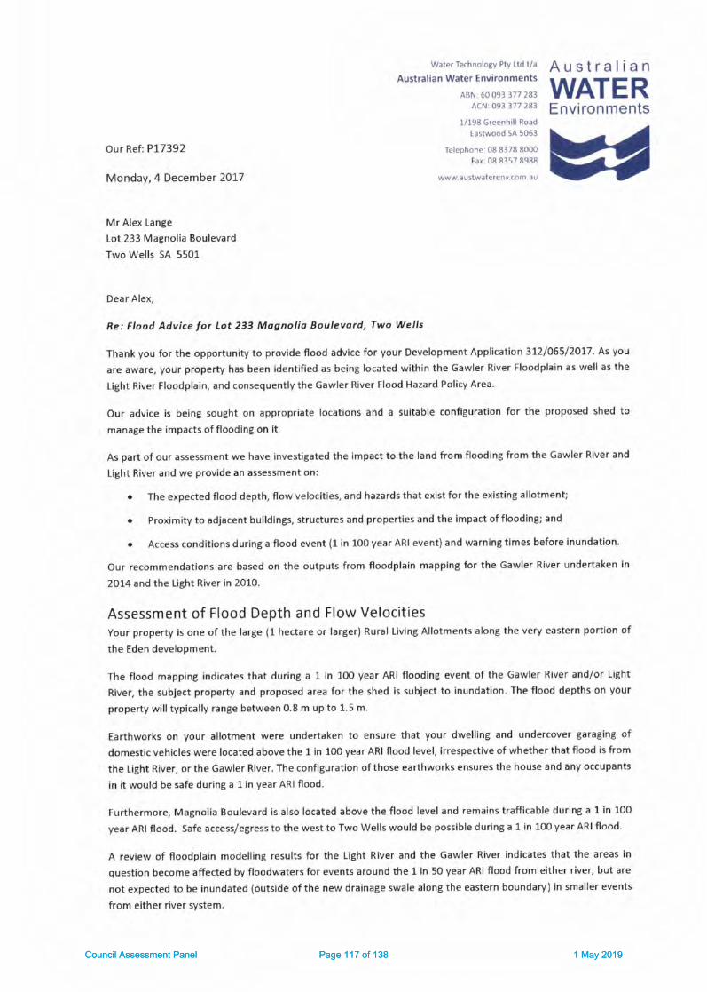
water Technolosy Pty Ltd t/a A U S t f a I i a nAustralian Water Environments
ABN6oos33772B3 WATERACNr 093 377 283
1/198 Greenhil Road
Eastwood SA 5053
Telephone 08 8378 8000
tax: 08 8157 8988
wwwau5twa(erenv.com.au
Environments
Our Ref: P17392
Monday, 4 December 201-7
Mr Alex Lange
Lot 233 Magnolia Bouleva rd
Two Wells SA 5501
Dear Alex,
Re: Flood Advice lor Lot 233 Mognolia Boulevard, Two Wells
Thank you for the opportunity to provide flood advice for your Development Application 3L7/O65/ZOT7. As You
are aware, your property has been identified as being located within the Gawler River Floodplain as well as the
light River Floodplain, and consequently the Gawler River Flood Hazard Policy Area.
Our advice is being sought on appropriate locations and a suitable configuration for the proposed shed to
manage the impacts of flooding on it.
As part of our assessment we have investigated the impact to the land from flooding from the Gawler River and
Light River and we provide an assessment on:
o The exoected flood depth, flow velocities, and hazards that exist for the existing allotment;
. Proximity to adjacent buildings, structures and properties and the impact of flooding; and
e Access conditions during a flood event {1 in 1O0 year ARI event) and warning times before inundation.
Our recommendations are based on the outputs from floodplain mapping for the Gawler River undertaken in
2014 and the Light River in 2010.
Assessment of Flood Depth and Flow Velocitiesyour property is one of the large (1 hectare or larger) Rural living Allotments along the very eastern portion of
the Eden development.
The flood mapping indicates that during a 1 in 1OO year ARI flooding event of the Gawler River and/or Iight
River, the subject property and proposed area for the shed is subject to inundation. The flood depths on your
property will typically range between O.8 m up to 1.5 m.
Earthworks on Vour allotment were undertaken to ensure that your dwelling and undercover garaging of
domestic vehicles were located above the 1 in 100 year ARI flood level, irrespective of whether that flood is from
the Light River, or the Gawler River. The configuration ofthose earthworks ensures the house and any occupants
in it would be safe during a 1in year ARI flood.
Furthermore, Magnolia Boulevard is also located above the flood level and remains trafficable during a 1 in 100
Vear ARI flood. Safe access/egress to the west to Two Wells would be possible during a 1 in lm year ARI flood.
A review of floodplain modelling results for the Light River and the Gawler River indicates that the areas in
question become affected by floodwaters for events around the I in 5O year ARI flood from either river, but are
not expected to be inundated (outside ofthe new drainage swale along the eastern boundary) in smaller events
from either river system.
Council Assessment Panel Page 117 of 138 1 May 2019Council Assessment Panel Page 117 of 138 1 May 2019

Whilst the flood waters are relatively deep, they are expected to be of very low velocity, typicallY less than o.2
m/s. At the proposed location of your shed the flood water velocity is expected to peak at approximately 0.19
m/s, progressively becoming slower again to the west (towards your house).
Our recommended location for your shed, along with a flood inundation map is provlded in Figure 1.
We suggest the shed should be located towards the northern side of the property and set 5 m in from your
northern boundary. The shed could also be set 55 metres east ofyour existint house pad.
f-----l o - o.1o
f.,Elolo 'o2s
I o.zs - o.so
Io.5o.l.mIi.oo-1.s0Ii.so-2.soflllz.so-s.oo
FIGUNE 1 FLOOD DEPIHS 1 IN 1OO YEAR ARI FI-OOD RISI(
The relevant flood statistics at the centriod of the proposed shed location are provided in Table 1.
TABTE I GAW|-ER RTVER/UGHT RTVER WETGHTED COMPOS|TE I tN 100 YEAR ARI FTOOD DETAII.S AT PROPOSED SHED SITE
Flow Velocity
Range (m/sfFlow Depth Range
lml
Watcr Surface
Elevation ImAHD)
Iat centroid of shedl
Flood Hazard
Rating
0.19 1.35 12.59 High
Assessment of Finished Floor LevelCouncil would normally require the flnlshed floor level of a shed {not habitable)to be set above the 1 in 1o0 year
ARI flood level with a freeboard of 15omm. This is to prevent inundation of the shed and damage to its contents
during a flood. This approach is termed dry flood proofing. lt would require a finished floor level of 12.74mAHD.
We understand that this is not considered acceptable to you and hence you have instructed us to advise you on
an alternative approach that provides for a lower finished floor level whilst also ensuring that the damages to
Recommended area
within which shed
should be located.
P17392 tot 233 Magnolia Blvd Two Wells Flood Advice v2-3 1712ort
Council Assessment Panel Page 118 of 138 1 May 2019Council Assessment Panel Page 118 of 138 1 May 2019

the shed and its contents are mlnlmlsed. lt ls also lmportant to conslder any safety lmpllcatlons for you, your
famlly and guests to the property.
ln this Instance we therefore conslder there ls merlt In the applicatlon of wet flood prooflng measures' Whllst
we cannot guarante€ that Council will accept our suggested approach, we conslder lt to be a practical means by
which the flood rlsk to your proposed shed can be managed.
Application of Wet Flood Proofing MeasuresThe use of wet flood prooflng technlques ls an accepted method by many authorltes for managlng non-
residential buildings in flood prone areas. (FEMA (2013)). We understand that Council has previously applled thls
approach In other nearby areas (such as the propertles backing onto the rallway reserve along Walter Avenue,
Two Wellsl and as well as in some of lts coastal settlements that are subject to sea water floodlng.
There are also a number of practlcal beneflts In thls case whlch Include:
. Settlng the sheds at a lower level would help to ensure that they are left unattended durlng a flood and
people effectvely evacuate the shed before surrounding flood waters become too deep and make it
less safe; and
o Establlshlng a lower floor level wlll reduce the volume of fill material to be placed in the floodplaln and
further minlmlse any dlsruptlon to the movement of floodwaters.
There are also a number of obllgatlons on you that adoptlng a wet flood prooffng approach requlres. These
lnclude:
r You wlll need to formally recognlse the flood rlsk and accept liability for any damages to your property
or damages to others that floodlng of the shed may cause. (Thls could be, for example, In the form of a
Land Management Agreement recognised on your tltle to ensure any future new landholders are also
aware of the floodlng lssues).
o The shed must not be habttable, nor ls lt used for that purpose.
r The shed wlll need to be deslgned by a suftably qualifled desitner to ensure that lt can wlthstand pardal
inundation, Includlng;
o Foundatlons for the sheds must be able to malntaln the necessary support for the structure
durlng a flood sltuatlon.
o The sectlons and areas of the shed potentlally Inundated should be constructed from flood
damage.reslstant materials to reduce flood damage and facllltate cleanup. (For example: walls
could be constructed of steel frames and claddlng (eg colour bond); any lnternal llnlngs should
be of water reslstant materlal, any tlmber work wlthln the lnundatlon depth should use marlne
grade tlmber products, floors should be concrete slabs or course gravels (eg 15 mm gravel), or
if flner rubble materlal ls used for floorlngs they should be cement treated)'
o theds to be configured to minimise damage from lnundatlon (eg water ls able to drain from
Inslde ofshed and layout Inslde the shed enables simple cleanlng offloor area etc.
o Shelvlng, any power outlets and any unsealed contalners, or stored material subject to damage
by floodwaters wlthtn the shed to be set 150 mm above the 1 ln 10o year ARI flood level (le no
lower than L2,74nAHD.
o The shed deslgner certlfoing that these condltlons are satlsfled.
. Any large plant or equipment stored in the shed (eg tractor, boat etc) that a susceptible to damage
from floodwaters are able to be readlly relocated to high ground out of the flood.
The above measures would promote the effectlve use of wet flood prooffng treatments to facilltate the
installatlon of a large shed / workshop and equlpment on your property in a practlcal way.
P17392 lot 233 Magnolla Blvd Two Wells Flood Advlce v2-3 1712O1
Council Assessment Panel Page 119 of 138 1 May 2019Council Assessment Panel Page 119 of 138 1 May 2019

Access requirementsAn lmportant requirement for managing flood risk is the effective and safe access to and from a property.
Safe access to and from the dwelling on your property from Two Wells township should be possible during a 1 in
100 year ARI flood event. Howarer, consideration also needs to be given for the access to and from your house
to the shed during a flood.
The best practice guidelines (SCARM, 2000) provide guidance on the flood condltlons that can be traversed by
wading (summarised in Table 2).
TABLE 2 : SCARM PmOl wAXtlNG CRITERIA
Criteria valueAble bodied adults maximum depth 1.2m (still water)Able bodied adults maximum velocitv O.8m/s (shallow water)
Notes: Surface, potholel fences and stormwat€r drains
and visibility must also be taken into account
There has also been a more recent study which reviewed the available literature on wading in flood conditions
(Entineers Australia, 2010). This study defines the flow hazard regimes for children, adults and trained safety
workers based on the product of depth and velocity (DxV (m'z/s)). fhe maximum safe depth for adults is the
same as determined by SCARM (200O). The recommendations from Engineers Australia (2010) are illustrated in
Figure 2.
Depth
l upper tirif rrrooe.ate nazat+ l/ | Dangerous to some' for adults wading l/ LUpper limlt for tralned safety workers_,1
Upper limlt 'Lo$/ Harard" tor adults wadinS andUpper limlt for "Significant Hazard danger to most"for Children wading
Chlldr€n (0.5m)
lrqrS*i;tL"",tr].- a*;0 vdoot (ov")
Endneers Aust6lh (20101 safety crlterla for Pcoph
FIGURE 2 : E GI EERS AUSIRAIIA (2o1ol SAFETY CRIIERIA FttR PEoPLE lN rlooD WATERS SUMMARISED Ol{ FTOOD HAZARD GRAPH
Engineers Australla (2O10) also notes that loss of stability could occur in lower flows when adverse conditions
are encountered including:
. Eottom conditlons: uneven, slippery obstacles;
. Flow conditions: floating debris, low temperature, poor vlslbllity, unsteady flow and flow aeration;
. Human subJect: whether they are standing or moving, whether they are experienced and have had
training, what clothing and footwear they are wearin& their physical attributes In additlon to height and
mass (on which the experiments were based) as well as dlsability and psychological factors;
. Other: strong wlnd, poor lighting, the point at which the person feels unable to continue (i.e. when they fall
over or when they initially begin to slip).
Hence consideratlon needs to be given as to access arrangement between the dwelling and the shed.
PU392 Lot 233 Magnolia Blvd Two Wells Flood Advice v2-3 171204
Council Assessment Panel Page 120 of 138 1 May 2019Council Assessment Panel Page 120 of 138 1 May 2019
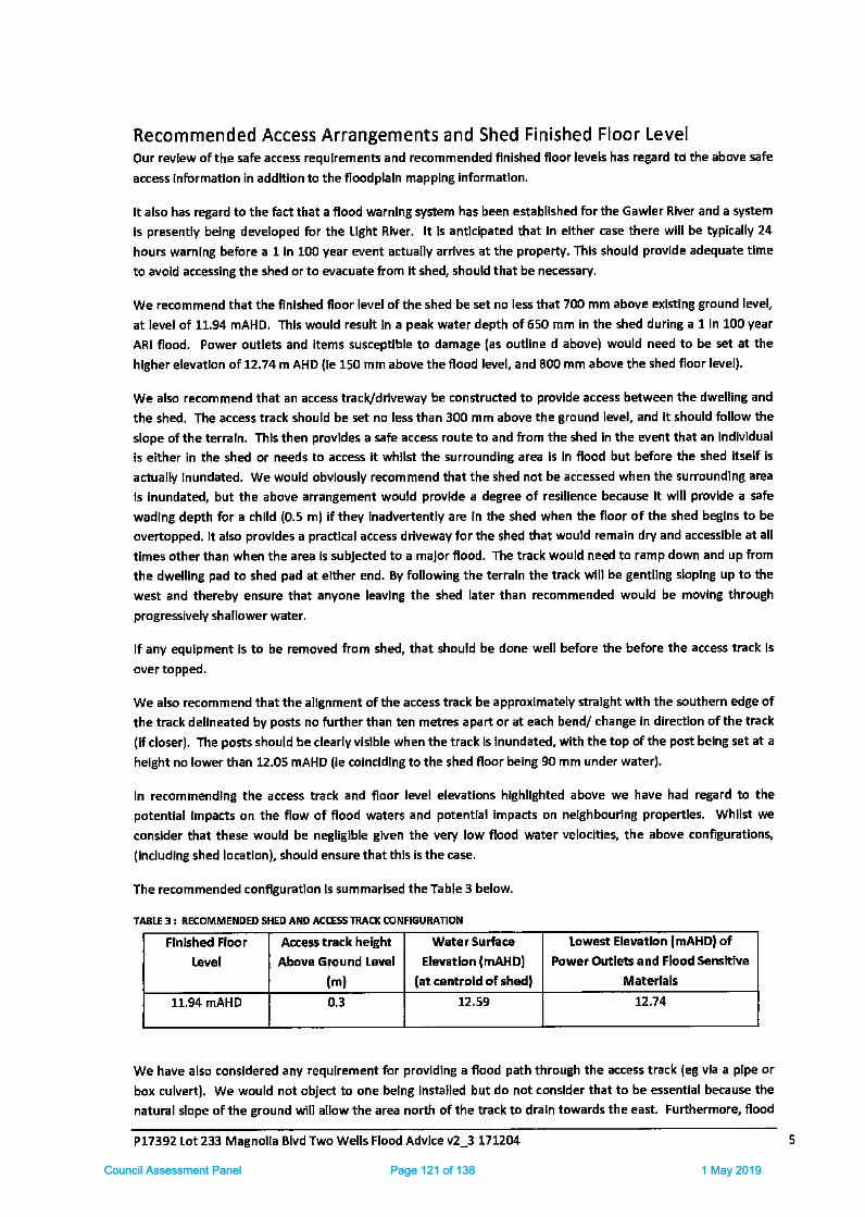
Recommended Access Arrangements and Shed Finished Floor LevelOur revlew ofthe safe access requlrements and recommended flnished f,oor levels has regard td the above safe
access Informatlon in addltlon to the floodplaln mapplng lnformatlon.
It also has regard to the fact that a flood warnlng system has been establlshed for the Gawler River and a system
ls presently belng developed for the Llght Rtuer. lt ls antlclpated that In elther case there wlll be typically 24
hours wamlng before a 1 In 10O year event actually arrlves at the pfoperty. This should provlde adequate tlme
to avoid accessing the shed orto evacuate from lt shed, should that be necessary.
We recommend that the finished floor level of the shed be set no less that 70O mm above exlstlng ground level,
at level of 11.94 mAHD. Thls would result In a peak water depth of 650 mm In the shed during a 1 in 100 year
ARI flood, Power outlets and items susceptlble to damage {as outllne d above} would need to be set at the
hfgher elevatfon of 12.74 m AHD (le 150 mm above the flood level, and 80O mm above the shed floor lorel).
We also recommend that an access track/drlveway be constructed to provlde access between the dwelllng and
the shed. The access track should be set no less than 3G) mm above the ground level, and lt should follow the
slope of the terraln. Thls then provldes a safe access route to and from the shed In the event that an Indlvldual
is either in the shed or needs to access it whllst the surroundlng area ls In flood but before the shed itself is
actually lnundated. We would obvlously recommend that the shed not be accessed when the surroundlng area
ls inundated, but the above arrangement would provlde a degree of reslllence because lt wlll provlde a safe
wadlng depth for a chlld (0.5 m) if they inadvertently are in the shed when the floor of the shed beglns to be
overtopped. lt also provldes a practlcal access driveway for the shed that would remain dry and accesslble at all
times other than when the area is subJected to a malor flood. The track would need to ramp down and up from
the dwelllng pad to shed pad at either end. By following the terraln the track wlll be gentllng sloplng up to the
west and thereby ensure that anvone leavlng the shed later than recommended would be moving through
progressively shallower water.
lf any equlpment ls to be removed from shed, that should be done well before the before the access track ls
over topped,
We also recommend that the allgnment of the access track be approximately stralght wlth the southern edge of
the track dellneated by posts no further than ten metres apart or at each bend/ change ln directlon ofthe track
(tf closer). The posts should be clearly vislble when the track ls Inundated, wlth the top of the post belng set at a
helght no lower than 12.05 mAHD (le colncldlng to the shed floor being 9O mm under water).
In recommendlng the access track and floor level elevatlons hlghllghted above we have had regard to the
potentlal lmpacts on the flow of flood waters and potentlal impacts on nelghbourlng propertles. Whllst we
consider that these would be negltglble glven the very low flood water velocities, the above configurations,
(lncludlng shed locatlon), should ensure that thls is the case.
The recommended conffguratlon ls summarlsed the Table 3 below.
TABIE 3 | RECOMMENDED SHED AND ACCE$ InAC-l( CONFIGURATION
Flnlshed Floor
Level
Access track helght
Above Ground Level
(ml
Water surface
Elevatlon (mAHDl
(at centrold of shedf
Lowest Elevetlon lmAHDl ofPow€r Outl€ts and Flood Sensftive
Materlals
11.94 mAHD 0.3 12.59 L2.74
We have also consldered any requlrement for providing a f,ood path through the access track (eg vla a plpe or
box culvert). We would not object to one belng Installed but do not conslder that to be essentlal because the
natural slope of the ground will allow the area north of the track to draln towards the east. Furthermore, flood
P77392 Lot 233 Magnolla Blvd Two Wells Flood Advlce v2_3 171204
Council Assessment Panel Page 121 of 138 1 May 2019Council Assessment Panel Page 121 of 138 1 May 2019

velocltles are low, the height ofthe track ls low when compared the maxlmum flood depth, and there are more
slgnlflcant hydraullc controlllng features downstream of your property (eg Gawler Roadf. Hence, the track we
describe ls not expected to create any slgnlffcant adverse floodlnt lmpacts,
We trust that the above information will be of assistance. Please do not he3ltate to contact me should you
requlre any firrther clarlflcatlon.
Yours slncerely,
/ /...'1i ../ L-
./l/Gaff Fisher
Reglonal ceneral Manager, SA
Austra lla n Wat€r Envlrc nmentr
References:
Englneers Australla l2c]0l Australian Rainloll ond Runoll Revision PrQed 7A: Approp ote Sofety Otterlo forPeople Stoge 7 Repoft
FEMA (2013) Floodprooffng Non-Resldentlal Bulldlngs. Publlshed by US Department of Homeland Security,
report FEMA P-936, 2013.
SCARM (2000). Floodplaln Monogement ln Australla. Best Prodlce Principles and Guidelines. Agriculture and
Resource Management Councll of Australla and New Zealand, Standlng Commlttee on Agrlculture and resource
Management Report no. 73.
Dl*lalmerThis document ls for the excluslve use of the cllent for whlch lt was prepared and ls not to be relled upon by any
other person. AWE has made reasonable efforts to ensure that the lnformatlon provlded ls accurate but errors
and omlsslons can occur and clrcumEtances can change from the tlme that the report or document was
prepared. Therefore, except for any llablllty that cannot be excluded by law, AWE excludes any llabllfty for loss
or damage, dlrect or lndlrect, from any person relylng (dlrectly or Indirectly) on oplnlons, forecasts, concluslons,
recommendatlons or other Informatlon In thls report or document.
P77392 Lot 233 Magnolla Blvd Two Wells Flood Advlce v2-3 171204
Council Assessment Panel Page 122 of 138 1 May 2019Council Assessment Panel Page 122 of 138 1 May 2019

created on mursday, 18 Apr 2019
'AADELAT DE PLAr NS couNcr L
This advlce and/or nforrnabon is qiven fcr your private us€ only. The ac.uracy of the
advice and informatron is not guaranteed arrd fo respon5 billtY is acceptei by AdelaidePlains Counc for any loss or damage caused by reliance upon this advice and/orLnfoflnat o|l, as a result of any errors, om ssion, inaorrect descrption or sfatement therein
Adelaide Plains Counc I
PO Box 18, Mallala, SA 5502T 08 852/ 0200F: 18 a\27 2242
Council Assessment Panel Page 123 of 138 1 May 2019Council Assessment Panel Page 123 of 138 1 May 2019
southf ront170 GreenhillRoad Parkslde SA 5061
P 8172 1088 E [email protected],auA8N 96 m7 344 191
Our Ref: 18005-3
12 April 2019
Rob VeitchGeneral Manager, Development and CommunityAdelaide Plains Council
PO Box 18MALLALA SA 5502
Dear Rob
Lange Shed (372106512017), Lot 233 Magnolia Boulevard, Two Wells - General
Advice on Flood Risk
Background
In March 2017 a Development Application was submitted to Adelaide Plains Council for the
construction of an outbuilding at Lot 233 Magnolia Boulevard, Two Wells (DA 312/055 l2OL7l. Iheapplicant (Mr Alex Lange) is represented by Regional Planning Directions who have described the
proposed outbuilding as being a shed for domestic purposes with a floor area of 219.9m'z (18,3
metres long by 12.015 metres wide).
Lot 233 Magnolia Boulevard is a 1.213 hectare ruralliving allotment in Hickinbotham's Eden
Development, and is located within the floodplain of both the Gawler River and Light River. In
correspondence dated 20 April 2017 Council requested clarification of the location of the shed in
order to determine whether the shed was in Flood Hazard Zone 3, and in March 2018 the applicant
submitted a flood advice report prepared by Australian Water Environments (AWE) dated 4
December 2017.
AWE's flood advice for the subject land dated 4 December 2017 states that "A teview ollloodplain
modelling results Ior the Light River ond the Gowler River indicotes thot the dreds in question become
olfected by floodwaters Iot events orcund the 1 in 50 yeor ARI flood from either river, but dre not
expected tobe inundated (outside ofthe new droinoge swole along the eostern boundory)in smo er
events from either river system".
As detaif ed in the flood advice by AWE, "Council would normally require the Jinished floor level oI o
shed (not hobitoble) to be set obove the 7 in 10O year ARI llood level with o freeboord of 15omm.
This is to prevent inundation of the shed and domoge to its contents during o flood. This approoch is
termed dryllood proofing". However in this instance the applicant proposes a finished floor level forthe shed that is lower than the 1 in 100 year ARI flood level, together with a range of 'wet floodproofing' measures in an effort to manage the inherent flood risk at the site.
Southfront have been engaged by Adelaide Plains Council to undertake a risk based assessment ofthe alternative flood proofing methods ('dry'versus'wef) as they relate to the proposed
outbuilding. The risk based assessment contained in this report has regard to the guidance offered
by Australian Rainfall and Runoff 2016 and the Australian Institute for Disaster Resilience's handbook
titled Monaging the Ftoodploin: A Guide to Best Practice in Flood Risk Management in Australia
Council Assessment Panel Page 124 of 138 1 May 2019Council Assessment Panel Page 124 of 138 1 May 2019

(Australian Disaster Resilience Handbook 7, Third Edition, Australian Government Attorney-Genera l's
Department, 2017).
Documents supplied by Council
The following documents were supplied by Council and have been reviewed in preparing this advice:
I Two Wells Stormwater Mandgement Plan (AWE dated 10 April 2017);
I Eden Lorge Sheds Flood Exposure (AWE dated 14 July 2017);
> Eden Estote, Two Wells - Shed in the Floodploin (PBA dated 20 July 2017);
I Outbuildings on the Gawler River Flood Ploin - Two Wells (Kelledy lones dated 22 September
2Ot7l;
I Flood Advice for Lot 23j Magnolio Boulevord, Two Wells (AWE dated 4 December 2017);
> Libefty (Two Wells) Detdiled Design Support - Eden Ldrge Blocks, Additiondl Site Fiiling (AWE
dated 29 May 2018);
I Proposol to erect o shed for domestic purposes ot Lot 233 Mognolio Boulevord, Two Wells (DA
312/065/2017 )(Regiona I Planning Directions dated 3 December 2018); and
> DA 312/065/2017 - Shed for Domestic Putposes at Lot 233 Magnolio Boulevord, Two Wells
(Kelledy Jones dated 3 April 2019).
Whilst we have reviewed the full range of background information provided by Council, this reportdoes not specifically address the planning and legal matters associated with the Development
Application. Rather th is report provides a qua litative assessment of the relative merits of dry versus
wet flood proofing as they relate to the subject land.
Design Rainfall Terminology
In 2016 the Australian Rainfall and Runoff (ARR) guideline update was released. The update was thefirst major revision since ARR 1987 and was the result of an improved understanding oftheAustralian rainfall landscape, gained through collection and analysis of 30 years of additional rainfalldata from over 8,000 rainfall gauges across the nation.
The update also initiated a change in rainfall probability terminology whereby the use of the termAverage Recurrence lnt€rval (ARl) was replaced with the term Annual Exceedance Probability forinfrequent rainfall events. Annual Exceedance Probability (AEP) is the probability or likelihood of an
event occurring or being exceeded within any given year, expressed as a percentage.
For consistency with the background information provided by Council and the catchment-scale
studies that inform the assessment of flood risk at this locale (which pre-date the release of ARR
2016), we have elected to retain use of the term ARI in this report, noting the following forcom pa rative purposes:
) A 1 in 20 year ARI event is equivalent to a 5% AEP;
) A 1 in 5O year ARI event is equivalent to a 2% AE P; and
> A 1 in 1OO year ARI event is equivalent to a 1% AEP.
A Risk Based Assessment of Dry versus Wet Flood Proofing
Australian Disaster Resilience Handbook 7 "oimsto encourage those with responsibility for manoging
flood risk to work towords achieving best proctice" and " improve community flood resilience using a
broad risk monogement hierorchy of ovoidonce, minimisotion ond mitigotion", wherein:
Council Assessment Panel Page 125 of 138 1 May 2019Council Assessment Panel Page 125 of 138 1 May 2019

) Risk avoidance is achieved by limiting the likelihood or negating exposure to the flood hazard;
) Risk minimisation is achieved by mitigating the consequences of the flood hazard; and
) Resfdual rlsk, which HandbookT defines as'the risk remaining, in both eisting and futuredevelopment dreas, ofier management measures such os works, land-use plonning and
develowent contols arc implemented", is understood and accepted.
A dry flood proofing approach, envisaged W aenerul Sec.ion - Hazords - Principtes oI Development
Controt - 6(b) ol the Development Plan and typically applied to a development of this nature, would
require the proposed outbuilding at Lot 233 Magnolia Boulevard to have a finished floor level ofL2.741AHD, providing 15Omm of freeboard to the peak 1 in 100 year ARI flood level at the site.
Freeboard is added to flood levels to provide reasonable certainty of achieving the desired level ofservice from setting a general standard or Defined Flood Event (Australian Disaster Resilience
Handbook 7). Under this scenario there would be residual flood risk to the outbuilding in events
greater than a 1 in 1O0 year ARl.
Rurat tiving Zane - Desired Chdracter Statement ofthe Adelaide Plalns Council Development Plan
states that "Dlrellings ond ancillary buildings ond strudures will he located and designed to Pevententry by floadwaterc. This will primarily be achieved through the rdising of fioor levels above the fiood!eve!, olthough alternative solutions may he appropiste in limited circum*ances provided speciflc
flood prooling measures ore included within ony design and construction"' On this basis the
applicant has proposed to construct the outbuilding with a finished floor level of 11.94mAHD, which
we understand would prevent the ingress of floodwaters in events up to"arcund the f in 50 yeal
ARI' and result in inundation ofthe outbuilding during largerflood events, with a peak inundatlon
depth of 65omm during a 1 in 1fi) year ARI event. Under this scenario there would be residual flood
risk to the outbuifding in events that are less than a 1 in 100 year ARl. As outlined in the Hood Advice
for Lot 233 Magnolio Boulevard, Two Wells (AWE dated 4 December 2017) the applicant has
proposed additional wet flood proofing measures to assist in managing the residual flood risk,
Flood risk can be managed by limiting the likelihood and/or consequences of a flood event. From
ARR 2015 Chapter 5; Flood isk is expressed in terms of combinations dthe likelihrcd of events
(generolly meosured in terms of Annual Exceedance Probdbility (AEP)) ond the seve ty of theconsequences olthe event. Risk is higher the morc Ircquently on oreo is etqosed to the same
consequence or vthen the same lrequency of event has higher consequences. By enabling more
frequent inundation of the proposed outbuilding at Lot 233 Magnolia Boulevard a wet flood proofing
approach would inherently result in a higher level offlood risk than for a dry flood proofing
approach.
ln considering this Development Application Council should also assess whether the suite ofadditional wet flood proofing measures proposed by the applicant would mitigate the consequences
ofa flood event to an acceptable levelforthe current occupiers ofthe land, guests to the property,
and the community at large; both now and in the future. ln observing that "we cannot guorontee
thot Counci! will occept out suggerted opptoodl",it is our interpretation that the author oftheapplicant's flood advice has foreshadowed Council's duty of care in determining whether this is
indeed the case.
The discussion below provides an overview ofthe risks associated with key aspects ofthe applicanfsproposed wet flood proofing approach.
Council Assessment Panel Page 126 of 138 1 May 2019Council Assessment Panel Page 126 of 138 1 May 2019

Filling in the Floodpla in
A dry flood proofing approach would require filling to a height of approximately 1.5 metres withinthe floodplain to achieve a finished floor level of 12.74mAHD for the proposed outbuilding at Lot 233
Magnolia Boulevard.
As a generalrule filling within a floodplain has the potential to locally increase ffood levels, whichmay adversely im pact adjoining properties and/or existing infrastructure. The applicant's flood
advice describes a practical benefit to the wet flood proofing method as " Establishing a lower floorlevel will reduce the volume of fill mdteriol to be placed in the floodplain and further minimise ony
disruption to the movement of floodwoterc" .
The impact of filling within a floodplain is typically assessed by incorporating the proposed fillenvelopes into a floodplain model and comparing the results to the base case. Such an exercise was
performed by AWE in May 2018 in support of the extended site filling along the western portion of223lo 235 Magnolia Boulevard (as part of a separate Category 3 Development Application). This
hydraulic modelling determined that "there will be no significdnt change in Ilood risk in relotion to
flood levels, velocities ond hozards os a result ofthe odditionolfill moteriol".
Given this finding, the floodplain model could be further updated to assess the impact of filling toachieve a dry flood proofing approach to the proposed outbuilding at Lot 233 Magnolia Boulevard, as
this would determine whether establishing a lower floor level for the proposed outbuilding offers a
genuine benefit.
Current and Future Use of Outbuilding
Australian Disaster Resilience Handbook 7 defines a habitable room as "ln o residential situation, o
living or working ared, such os a lounge room, dining room, rumpus room, kitchen, bedroom orworkroom. ln on industrial or commerciol situotion, it relers to dn drea used for offices or to storevaluoble possessions susceptible to flood domoge in the event oI o flood" .
The Development Application and supporting documentation suggests that the proposed outbuilding"witt not be habitable", while also describing the proposed outbuilding as a "lorge shed / workshop"
with various uses including th e "storoge of vehicles, caravan, boat, trador ond mower, plus personol
workshop for mointenonce ond hobbies" ,
Based on this description it would be reasonable to conclude that the proposed outbuilding would be
habitable as defined by Australian Disaster Resilience Handbook 7, on the basis that it is intended tobe used as a "workroom" and for the storage of a range of valuable possessions.
Electricity
The most serious consequence of flooding is the risk of fatality to individuals who may interact withhazardous flood situations. Australian Disaster Resilience Handbook 7 identifies electrocution as a
cause of fatalities during floods. The applicant's proposed wet flood proofing methods require" power outlets ond any unsealed containers, or stored moteriol suhject to domoge by lloodwatetswithin the shed to be set 750 mm obove the 7 in 700 yeor ARI flood level". lrrespective of whateveragreement may be put in place between Council and the currenvfuture landowner to assign liabilityfor damages to property and persons caused by flooding, the potentialfor death or serious injuryresulting from failure to comply with these requirements is a broader public safety issue for Council
consideration.
Failure to comply with the proposed wet flood proofing requirements may result incidentally duringday to day use of the outbuilding, such as persons leaving mains powered equipment on the floor,
Council Assessment Panel Page 127 of 138 1 May 2019Council Assessment Panel Page 127 of 138 1 May 2019
shelves or benches that are below the 1 in 100 vear ARI flood level. There is also a possibility thatcurrent/future landowners install power outlets at a level below the 1in lOO year ARI flood level.
Access Provisions and Flood Warning Times
The applicant's flood advice provides a comprehensive assessment of safe access provisions between
the dweffing and the shed, and highlights lhat "a flood warning system hos been estoblished Ior theGawler River and o system is presently being developed for the Light River. lt is onticipated thot in
eithet cose there will be typically 24 hours warning before o 7 in 1ffi yeor event actuolly orrives at theprcperty. This should provide adequote time to ovoid occessing the shed or to evocuote Irom theshed, should thot prove necessary'' .
Having regard to AWE's characterisation of the floodplain behaviour at this locale, it is expected thatthe applicant's proposed safe access provisions would be effective in facilitating the evacuation ofpersons from the proposed outbuild ing, provided that the safe access provisions are used as
intended, and that all current and future occupants of the land (including rental tenants, visitors,
house sitters etc) are made aware of and subscribe to the flood warning system.
However there are a number of practica I matters that should be considered by Council in
determining whether the proposed safe access provisions and flood warning system would prove
effective in mitigating the risk of property damage, including:
) The potential consequences of the property being unattended during a flood event (eg. when the
occupants are away on holiday);
) The adequacy of the typical 24 hour warn ing time in enabling the occupants to implement a n
evacuation plan for the valuable possessions that are proposed to be stored within theoutbuilding;
) Whether a sufficient area of "high ground" exists on the property to enable the evacuation of thevaluable possessions that are proposed to be stored within the outbuilding; and
) Whether the proposed flood warning system and associated evacuation plan would be
acceptable to any third parties who have an interest in vehicles or equipment or goods that areproposed to be stored within the outbuilding (eg, financiers, purchasers of equipment or goods).
Based on the above circumstances it would be reasonable to conclude that a high risk of property
damage would remain under a wet flood proofing approach.
Water Level Equalisation and Outbuilding Security
The wet flood proofing measures outlined in the report tilled Eden Lorge Sheds Flood Exposure IAWEdated 14 jufy 2017) included that " Provision is mdde along the northern ond southern side of each
shed Jor two flood flaps on eoch side of the building (eoch o minimum of 0.5% of the inundated orea
or 7.0m wide by o3m high, which ever is the gredtet) to operate freely and allow lor water levels toequolise within and outside olthe shed in times ol o flood ond also ollow wster to passthrough the
shed". Flap gates are a widely accepted method of achieving water level equalisation in stormwatermanagement systems.
The applicant's subsequent flood advice did not include the provision for flap gates and therefore itremains unclear how the design of the proposed outbuilding would achieve water level equalisation.
It is also noted that flap gates are not typically used in circumstances where their operation can
facilitate unauthorised access to valuable private property,
Council Assessment Panel Page 128 of 138 1 May 2019Council Assessment Panel Page 128 of 138 1 May 2019

Summary
The applicant's proposed wet flood proofing approach, while not without merit, would lowerthethreshold at which the proposed outbuilding would be subject to a residualflood risk to less than a 1
in 100 year ARI event. The proposed wet flood proofing approach also carries a higher risk, throughthe potential circumstances that could give rise to an increased likelihood and/or consequence offlood damage, than a conventional dry flood proofing approach.
It is therefore recommended that Council require a dry ffood proofing approach to be adopted forthe proposed outbuilding at Lot 233 Magnolia Boulevard, Two Wells (DA 312/065/2017).
Please do not hesitate to call me on 8172 1088 if you require any further information regarding theabove,
Brett ShuttleworthSenior Engineer
Yours sincerely
Aflrfu*t
Council Assessment Panel Page 129 of 138 1 May 2019Council Assessment Panel Page 129 of 138 1 May 2019

Council Assessment Panel Page 130 of 138 1 May 2019Council Assessment Panel Page 130 of 138 1 May 2019

Council Assessment Panel Page 131 of 138 1 May 2019Council Assessment Panel Page 131 of 138 1 May 2019

Council Assessment Panel Page 132 of 138 1 May 2019Council Assessment Panel Page 132 of 138 1 May 2019

Council Assessment Panel Page 133 of 138 1 May 2019Council Assessment Panel Page 133 of 138 1 May 2019

Council Assessment Panel Page 134 of 138 1 May 2019Council Assessment Panel Page 134 of 138 1 May 2019

Council Assessment Panel Page 135 of 138 1 May 2019Council Assessment Panel Page 135 of 138 1 May 2019

Council Assessment Panel Page 136 of 138 1 May 2019Council Assessment Panel Page 136 of 138 1 May 2019

Council Assessment Panel Page 137 of 138 1 May 2019Council Assessment Panel Page 137 of 138 1 May 2019

Council Assessment Panel Page 138 of 138 1 May 2019Council Assessment Panel Page 138 of 138 1 May 2019