ontario specification for gps control surveys · · 2014-03-04the ontario specification for gps...
TRANSCRIPT

GO-ITS 45.3 Status: Approved Version 1.0
– 1 –
Ontario Specification for GPS Control Surveys
Government of Ontario IT Standards (GO-ITS)
Document No. 45.3 Version 1.0
Status: Approved
OCCIO/OCCTO MANAGEMENT BOARD SECRETARIAT CORPORATE ARCHITECTURE BRANCH TECHNICAL STANDARDS SECTION
Last Review Date: June 14, 2005
GO-ITS 45.3 Status: Approved Version 1.0
– 2 –
Foreword
Government of Ontario Information & Technology Standards are the official publications on the standards, guidelines, technical reports and preferred practices adopted by the Information Technology Standards Council under delegated authority of the Management Board of Cabinet. These publications support the Management Board Secretariat's responsibilities for coordinating standardization of Information and Technology in the Government of Ontario. Publications that set new or revised standards provide policy guidance and administrative information for their implementation. In particular, they describe where the application of a standard is mandatory and specify any qualifications governing its implementation.

GO-ITS 45.3 Status: Approved Version 1.0
– 3 –
Table Of Contents
INTRODUCTION ..................................................................................................................................................... 4
Applicability ...................................................................................................................................................... 4 Requirement Levels ......................................................................................................................................... 4 Purpose of the Standard .................................................................................................................................. 5 Recommended Versioning and/or Change Management ................................................................................ 6
Contact Information ...................................................................................................................................................... 6
Type of Standard .............................................................................................................................................. 7 Publication ........................................................................................................................................................ 7 Acknowledgements .......................................................................................................................................... 8
Development Team ...................................................................................................................................................... 8 Name ........................................................................................................................................................................ 8
Impacts to Standards ..................................................................................................................................... 11 Impacts to Existing Environment .................................................................................................................... 12
ONTARIO SPECIFICATION FOR GPS CONTROL SURVEYS ........................................................................... 13
Abstract .......................................................................................................................................................... 13 Category ......................................................................................................................................................... 13 Related Documents ........................................................................................................................................ 13 Specifications ................................................................................................................................................. 14 Qualifications .................................................................................................................................................. 14 Implementation ............................................................................................................................................... 14 Where to obtain copies................................................................................................................................... 15 Errata .............................................................................................................................................................. 15 Copyright ........................................................................................................................................................ 15
APPENDIX A: ONTARIO SPECIFICATION FOR GPS CONTROL SURVEYS BUSINESS CASE .................... 16
APPENDIX B: ONTARIO SPECIFICATION FOR GPS CONTROL SURVEYS, VERSION 1.2, JUNE 2004, GEOMATICS OFFICE, MTO AND PROVINCIAL GEOREFERENCING, MNR ................................................... 31

GO-ITS 45.3 Status: Approved Version 1.0
– 4 –
Introduction
Applicability
Government of Ontario IT Standards and Enterprise Product Standards apply (are mandatory) for use by all ministries/clusters and to all former Schedule l and lV provincial government agencies under their present classification (Advisory, Regulatory, Adjudicative, Operational Service, Operational Enterprise, Trust or Crown Foundation) according to the current agency classification system. Additionally, this applies to any other new or existing agencies designated by Management Board of Cabinet as being subject to such publications.
Requirement Levels
GO-ITS documents may combine mandatory and non-mandatory information as necessary to effectively describe the requirements of a standard.
It is important to indicate clearly when a requirement is mandatory.
Where indicated throughout this standard, the terms ‘must’ and ‘should’ will be interpreted as follows:
Must; is mandatory (new standards are not retroactive, but new standards must be complied with at the next procurement/project opportunity)
Should; is best practice, already vetted, advantage to use, expedites approval process

GO-ITS 45.3 Status: Approved Version 1.0
– 5 –
Purpose of the Standard
This standard describes the Ontario Specification for GPS Control Surveys which specifies the requirements for all Global Positioning System (GPS) geodetic control surveys intended for inclusion or loading into the provincial geodetic control database known as COSINE (COntrol Survey INformation Exchange). The Ontario Specification for GPS Control Surveys was developed cooperatively by the Ministry of Transportation, Ontario (MTO) and the Ontario Ministry of Natural Resources (MNR). These two ministries carry out or are responsible for the majority of geodetic control survey work in the province intended for inclusion in COSINE. This standard is not specific to a single ministry or agency.
Adopting the Ontario Specification for GPS Control Surveys as a provincial GO-ITS standard will:
a) provide a standard for horizontal geodetic positioning using GPS technology for Ontario,
b) provide a standard for three-dimensional (3-D) geodetic positioning (horizontal and ellipsoidal height) using GPS technology for Ontario,
c) ensure that all GPS projects destined for COSINE from provincial government ministries, agencies and municipalities comply with the same standard,
d) enhance awareness that GPS technology provides different positioning accuracies dependent upon how the technology is used in the field, and
e) help to ensure the integrity of the geospatial reference framework for Ontario held in the provincial geodetic database known as COSINE.

GO-ITS 45.3 Status: Approved Version 1.0
– 6 –
Recommended Versioning and/or Change Management
The impact on organizational arrangements, staff, customers and service delivery can be summarized as follows:-
MNR and MTO clients, staff, stakeholders, and partners need to be aware that GPS technology can be deployed in the field using different techniques. To obtain the high levels of accuracy needed to support a geodetic control framework, the Ontario Specification for GPS Control Surveys has been developed for all projects destined for the provincial geodetic database known as COSINE (COntrol Survey INformation Exchange).
To ensure the project is completed in a cooperative way, with the least possible disruption the ITIL change management process which is a standard within the LRC will be applied.
Staff, clients and stakeholders will be informed and trained through one-on-one contract with Geomatics Office, MTO or Provincial Georeferencing, MNR staff.
Ongoing change will be managed through the ITIL Change management process that is a standard within the LRC.
Contact Information
Contact 1 Contact 2
Name J. Morgan Goadsby Ron Berg
Organization/ Ministry MNR MTO
Division Science and Information Resources Division
Policy, Planning and Standards Division
Branch Information Resources Management Branch
Engineering Standards Branch
Section/ Unit Geographic Information Ontario, Provincial Georeferencing
Geomatics Office
Office Phone (705) 755-2132 (905) 704-2330
GO-ITS 45.3 Status: Approved Version 1.0
– 7 –
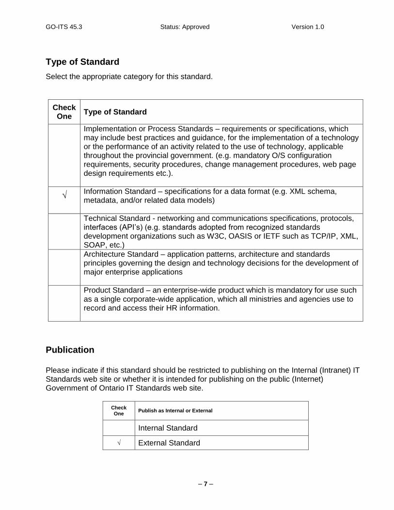
Type of Standard
Select the appropriate category for this standard.
Check One
Type of Standard
Implementation or Process Standards – requirements or specifications, which may include best practices and guidance, for the implementation of a technology or the performance of an activity related to the use of technology, applicable throughout the provincial government. (e.g. mandatory O/S configuration requirements, security procedures, change management procedures, web page design requirements etc.).
√ Information Standard – specifications for a data format (e.g. XML schema, metadata, and/or related data models)
Technical Standard - networking and communications specifications, protocols, interfaces (API’s) (e.g. standards adopted from recognized standards development organizations such as W3C, OASIS or IETF such as TCP/IP, XML, SOAP, etc.)
Architecture Standard – application patterns, architecture and standards principles governing the design and technology decisions for the development of major enterprise applications
Product Standard – an enterprise-wide product which is mandatory for use such as a single corporate-wide application, which all ministries and agencies use to record and access their HR information.
Publication
Please indicate if this standard should be restricted to publishing on the Internal (Intranet) IT Standards web site or whether it is intended for publishing on the public (Internet) Government of Ontario IT Standards web site.
Check One
Publish as Internal or External
Internal Standard
√ External Standard

GO-ITS 45.3 Status: Approved Version 1.0
– 8 –
Acknowledgements
Provide a list of individuals and stakeholder groups that contributed to the development of this standard, including those who helped write the standard and provided subject expertise as well as those groups or individuals contacted for input/comments. (see next table for list of governance bodies and other groups that had input)
Development Team
Name Cluster/Ministry Branch
Ron Berg Transportation/MTO Engineering Standards Branch, Geomatics Office
Robin Poot Transportation/MTO Engineering Standards Branch, Geomatics Office
Trevor Holiday Transportation/MTO Engineering Standards Branch, Geomatics Office
J. Morgan Goadsby LRC/MNR Information Resource Management Branch, Provincial Georeferencing
Peter Heney LRC/MNR Information Resource Management Branch, Provincial Georeferencing
(Primary team for the development of the new Ontario Specification for GPS Control Surveys)
J. Morgan Goadsby LRC/MNR Information Resource Management Branch
Anne Trudell LRC/MNR Science Information Branch
Dr. Carey Gibson LRC/MNR Information Resource Management Branch
Melanie Blamire LRC/MNR Information Resource Management Branch
Shawn Kelleher LRC/MNR Information Resource Management Branch
Ron Berg Transportation/MTO Engineering Standards Branch
Peter Hanmore LRC/MNR Information Resource Management Branch
Colleen Melanson LRC/MNR Information Resource Management Branch
Dr. Laura Kingston Transportation/MTO Engineering Standards Branch
Dennis Gertridge LRC/MNR Information Resource Management Branch
(All members of the LRC/OPS Geomatics Standards Working Group (GSWG))

GO-ITS 45.3 Status: Approved Version 1.0
– 9 –
Reviewers: in addition to the development team members listed above, please list others contacted for input/comments in the table below:
Check Area Date:
(month/year)
Technical Standards Unit, Corporate Architecture Branch, OCCTO May 2005
Corporate Architecture Branch (CAB Architects), OCCTO
Infrastructure Development Branch & iSERV, OCCSD
Corporate Security Branch, OCCS
Strategy, Policy, Planning and Management Branch (SPPM, OCCS)
Corporate ACT and Domain Working Groups July 2004
Information Architecture Domain (IADWG)
Technology Architecture Domain (TADWG)
Application Architecture Domain (AADWG)
Security Architecture Working Group (SAWG)
Cluster ACT/ARB (for cluster standards promoted to corporate standards) April 2004
ITSC members (provide name)
Interministerial Committee on Land Information (ICLI) Working Group June 2003
Information Resources Management Branch – Branch Leadership Team May 2003
Dr. Michael R. Craymer, Team Leader, Geodetic Networks, Geodetic Survey Division, Natural Resources Canada
January – Feb, 2004
Dan Lymer, P. Eng., O.L.S., Manager Data Integration Services, City of Toronto
January – Feb., 2004
Mike MacLean, Administrator, Land Information Services, City of Peterborough
January – Feb., 2004
John Struik, Graphic Services Coordinator, Geographic Information Services, City of Barrie
January – Feb., 2004
Jerome Katekyeza, Camara Geomatic Technologies (MTO Approved Control Surveys Consultant List)
Fall 2003
Robert Parr, Elliot and Parr (Peterborough) Limited (MTO Approved Control Surveys Consultant List)
Fall 2003
Robin Fleguel, Everest Geodetics (MTO Approved Control Surveys Consultant List)
Fall 2003
Ewart Bowlby, Fairhall, Moffatt & Woodland Limited (MTO Approved Control Surveys Consultant List)
Fall 2003

GO-ITS 45.3 Status: Approved Version 1.0
– 10 –
Richard Emode, Geomatic International Technologies Inc. (MTO Approved Control Surveys Consultant List)
Fall 2003
Joseph Young, J.D. Barnes Limited (MTO Approved Control Surveys Consultant List)
Fall 2003
Stephen Giddings, Marshall Macklin Monaghan Limited (MTO Approved Control Surveys Consultant List)
Fall 2003
Glenn Dawson, Monteith & Sutherland Limited (MTO Approved Control Surveys Consultant List)
Fall 2003
James Ferguson, Mosaic Mapping Systems Inc. (MTO Approved Control Surveys Consultant List)
Fall 2003
Eric Rody, Sutcliffe Rody Quesnel Inc. (MTO Approved Control Surveys Consultant List)
Fall 2003
Robert Forbrigger, Triathlon Ltd. (MTO Approved Control Surveys Consultant List)
Fall 2003

GO-ITS 45.3 Status: Approved Version 1.0
– 11 –
Impacts to Standards
List any existing GO-ITS that may be impacted or associated with this standard.
GO-ITS # Describe Impact Recommended Action (or page number where details can be found)
GO-ITS 45.1 NAD83
The proposed GO-ITS for the Ontario Specification for GPS Control Surveys sets the standards for use of high-precision GPS to build onto the control survey reference framework in the NAD83 reference system.
None – Complimentary to GO-ITS 45.1 NAD83
GO-ITS 45.2 NTv2
The proposed GO-ITS for the Ontario Specification for GPS Control Surveys sets the standards for the use of high-precision GPS to build onto the control survey reference framework in the NAD83 reference system. If users need to transform data between the NAD27 and NAD83, then the NTv2 can be used to transform coordinate information. Control Survey Reference points need to be rigorously computed/determined in the NAD83 system
Ensure users are aware that the NTv2 is available to transform data between NAD27 and NAD83, but that high-precision reference points must be rigorously determined/computed in the NAD83 system through precise survey methods (usually using GPS technology).
GO-ITS 29 ORN already uses NAD83 as the standard geo-referencing system. The Ontario Specification for GPS Control Surveys provides the requirements to build onto the control survey reference framework in NAD83, which would thus provide more reference points on which the ORN could be related
None – Complimentary to GO-ITS 29
GO-ITS 72 Geo-spatial Metadata Standard has field for (geodetic) datum. The Ontario Specification for GPS Control Surveys specifies the GPS methods to be used to build onto the control survey reference framework in the NAD83 datum.
None
GO-ITS 24 Omnibus Standard lists GO-ITS used by industry in Ontario. The Ontario Specification for GPS Control Surveys has been accepted and in use by Ontario industry and municipalities for over one year.
Add GO-ITS 45.3 Ontario Specification for GPS Control Surveys to list of GO-ITS used by Ontario Industry.

GO-ITS 45.3 Status: Approved Version 1.0
– 12 –
Impacts to Existing Environment
List any significant impacts this standard may have on the existing I&IT environment.
Application(s) or Infrastructure Impacted
Describe Impact Recommended Action (or page number where details can be found)
Specifications for GPS Control Surveys – Draft 1.0, March 1997, Surveys and Mapping Section, MTO
This 1997 Draft Specification is replaced by the Ontario Specification for GPS Control Surveys – June 2004
MTO is already requiring new projects to adhere to the new Ontario GPS Specification for GPS Control Surveys. Consultants are already performing work in accordance with the new specification.
Provisional Specifications for GPS Control Surveys, March 1994, Geodetic Services Unit, MNR
This 1994 Provisional Specification is replaced by the Ontario Specification for GPS Control Surveys – June 2004
MNR is already requiring new projects to adhere to the new Ontario GPS Specification for GPS Control Surveys. Consultants and municipalities are already adhering to the new specification.

GO-ITS 45.3 Status: Approved Version 1.0
– 13 –
Ontario Specification for GPS Control Surveys
Abstract
This standard describes the Ontario Specification for GPS Control Surveys which specifies the requirements for all Global Positioning System (GPS) geodetic control surveys intended for inclusion or loading into the provincial geodetic control database known as COSINE (COntrol Survey INformation Exchange). The Ontario Specification for GPS Control Surveys was developed cooperatively by the Ministry of Transportation, Ontario (MTO) and the Ontario Ministry of Natural Resources (MNR). These two ministries carry out or are responsible for the majority of geodetic control survey work in the province intended for inclusion in COSINE. This standard is not specific to a single ministry or agency.
Category
This is a mandatory standard.
Any GPS geodetic control survey, whether two-dimensional (horizontal) or three-dimensional (horizontal and ellipsoidal height) that is intended for loading in the provincial geodetic control database known as COSINE, shall follow these specifications.
Related Documents
Provisional Specification for GPS Control Surveys, March 1994. Ontario Ministry of Natural Resources. This is the previous Specification for GPS Control Surveys issued by Provincial Georeferencing, MNR. Ontario Specifications for Horizontal Control Surveys, 1979 (OS 79) and Ontario Guidelines for Horizontal Control Surveys, 1979 (OG 79, published by the Ministry of Natural Resources. This is the current Ontario Provincial Specification governing conventional (non-GPS) geodetic control surveys.
Surveyor General’s Memo of 1984/04/11 to the Association of Ontario Land Surveyors regarding New Monumentation Specifications for Horizontal and Vertical Control Surveys. This memo describes the general requirements for monumentation for geodetic control surveys (GPS and non-GPS) which are intended for inclusion in COSINE, the provincial geodetic control database.

GO-ITS 45.3 Status: Approved Version 1.0
– 14 –
Specifications for GPS Control Surveys, Draft 1.0, March 1997. Ministry of Transportation, Ontario (MTO). This is the previous Specification for GPS Control Surveys issued by the Geomatics Office, MTO.
Accuracy Standards for Positioning, Version 1.0, September 1996. Geodetic Survey Division, Geomatics Canada, 615 Booth Street, Ottawa. This is the current federal specification dealing with the accuracy standards for different positioning methods, including GPS. Guidelines and Specifications for GPS Surveys, Release 2.1, December 1992. Geodetic Survey Division, Geomatics Canada, 615 Booth Street, Ottawa. This is the current federal guideline and specifications document recommending how GPS should be used in the field for control surveys.
Specifications
Ontario Specification for GPS Control Surveys, Version 1.2, Geomatics Office, MTO and Provincial Georeferencing, MNR.
This is the Ontario Specification regarding geodetic control surveys using GPS technology, which are planned for inclusion in the provincial database known as COSINE.
Qualifications
This standard applies to all ministries, provincial government agencies and municipalities who conduct GPS control surveys destined for inclusion in the provincial geodetic database known as COSINE (COntrol Survey INformation Exchange). Any organization that is implementing this standard must do so in accordance with the technical information and specifications as provided in the Ontario Specification for GPS Control Surveys Business Case (Appendix “A”) and the Ontario Specification for GPS Control Surveys, June 2004 (Appendix “B”).
Implementation
The effective date of this standard is 2005/06/14.
Compliance with this standard will be achieved by conducting GPS control surveys in accordance with the specification and technical requirements of the standard attached as Appendix “B”.

GO-ITS 45.3 Status: Approved Version 1.0
– 15 –
Where to obtain copies
Copies of related documents may be obtained from:
Provincial Georeferencing, GIO, MNR 2nd Floor, North Tower, Robinson Place 300 Water Street Peterborough, ON K9J 8M5 Email: [email protected] or Geomatics Office, MTO 2nd Floor, Garden City Tower 301 St Paul Street St. Catharines, ON L2R 7R4
Email: [email protected]
Errata
Created: April 08, 2005
Updated: Month Day, Year
Approved by IT Standards Council May 18, 2005
Approved by Corporate Architecture Review Board June 14, 2005
Copyright
© Queen's Printer for Ontario 2005.

GO-ITS 45.3 Status: Approved Version 1.0
– 16 –
Appendix A: Ontario Specification for GPS Control Surveys Business Case

GO-ITS 45.3 Status: Draft Version 1.0
31
Appendix B: Ontario Specification for GPS Control Surveys, Version 1.2, June 2004, Geomatics Office, MTO
and Provincial Georeferencing, MNR